Article

Mapping Habitat Suitability of Migratory Birds During Extreme Drought of Large Lake Wetlands: Insights from Crowdsourced Geographic Data

1
School of Civil and Surveying & Mapping Engineering, Jiangxi University of Science and Technology, No. 1958, Kejia Ave., Ganzhou 341000, China
2
Jiangxi Provincial Key Laboratory of Water Ecological Conservation in Headwater Regions, Jiangxi University of Science and Technology, No. 1958, Kejia Ave., Ganzhou 341000, China
3
Key Laboratory of Spatial Data Mining and Information Sharing of Ministry of Education, Fuzhou University, No.2, Wulongjiang North Ave., Fuzhou 350108, China
*
Author to whom correspondence should be addressed.
Land 2025, 14(6), 1236; https://doi.org/10.3390/land14061236
Submission received: 17 April 2025 / Revised: 29 May 2025 / Accepted: 5 June 2025 / Published: 9 June 2025

Abstract

:
Comprehending the alterations in wintering grounds of migratory birds amid global change and anthropogenic influences is pivotal for advancing wetland sustainability and ensuring avian conservation. Frequent extreme droughts in the middle and lower Yangtze River region of China have posed severe ecological and socio-economic dilemmas. The integration of internet-derived, crowdsourced geographic data with remote-sensing imagery now facilitates assessments of these avian habitats. Poyang Lake, China’s largest freshwater body, suffered an unprecedented drought in 2022, offering a unique case study on avian habitat responses to climate extremes. By harnessing social and online platforms’ media reports, we analyzed the types, attributes and proportions of migratory bird habitats. This crowdsourced geographic information, corroborated by Sentinel-2 optical remote-sensing imagery, elucidated the suitability and transformations of these habitats under drought stress. Our findings revealed marked variations in habitat preferences among bird species, largely attributable to divergent feeding ecologies and behavioral patterns. Dominantly, shallow waters emerged as the most favored habitat, succeeded by mudflats and grasslands. Remote-sensing analyses disclosed a stark 60% reduction in optimal habitat area during the drought phase, paralleled by a 1.5-fold increase in unsuitable habitat areas compared to baseline periods. These prime habitats were chiefly localized in Poyang Lake’s western sub-lakes. The extreme drought precipitated a drastic contraction in suitable habitat extent and heightened fragmentation. Our study underscores the value of crowdsourced geographic information in assessing habitat suitability for migratory birds. Retaining sub-lake water surfaces within large river or lake floodplains during extreme droughts emerges as a key strategy to buffer the impacts of hydrological extremes on avian habitats. This research contributes to refining conservation strategies and promoting adaptive management practices of wetlands in the face of climate change.

1. Introduction

Wetlands, recognized as ecosystems of exceptional biodiversity and primary productivity [1,2], serve as vital refugia for wintering migratory birds, providing indispensable habitat, sustenance and a conducive ecological environment [3,4,5]. These avian populations’ survival and reproductive success hinge critically on the preservation and rehabilitation of wetland environments, underscoring the paramount importance of such conservation endeavors. The vegetative growth dynamics within wetlands significantly influence the availability of food resources and the selection of suitable habitats by migratory birds [6,7]. Variations in meteorological conditions and hydrological regimes markedly shape the characteristics of wetland vegetation [8,9,10,11], thereby exerting a profound effect on both the timing and behavior of avian migrations.
Global wetlands are grappling with immense challenges due to the convoluted implications of climate change and anthropogenic activities, manifesting in area reduction, diminished ecological functionality and arduous restoration prospects [1,12,13]. Among the myriad disturbances confronting wetlands worldwide, extreme drought events emerge as formidable adversaries to the integrity of wetland ecological structures and functions [14]. A case in point is the unprecedented drought in 2022, which precipitated a marked decline in the ecological efficacy of Poyang Lake, China’s largest freshwater body. This environmental upheaval significantly impinged upon the foraging capabilities and habitat suitability for wintering migratory birds [15,16,17], with the lake’s water levels plummeting to unprecedented lows unseen in the preceding seven decades [18,19,20]. Consequently, the repercussions of such extreme droughts on avian habitats have vaulted to the forefront of scientific inquiry, policy formulation and public discourse.
Habitat suitability gauges the environment’s capacity to furnish propitious conditions for wildlife populations [15,21]. This metric has gained prominence over recent decades, catalyzing the development and extensive application of habitat suitability models or indices in assessments aimed at guiding ecological conservation and resource administration [22,23,24]. Remote sensing and GIS have been widely applied in habitat suitability evaluation [21,23]. Remote sensing can provide many variables related to habitat quality, such as land cover, vegetation type, topography, hydrological conditions and even surface temperature [21,25]. In recent years, remote-sensing image data have been used for habitat suitability evaluation of wintering waterbirds, Asian elephants and some invasive species [25,26,27].
The advent of advanced internet and smart terminal technologies has ushered in a new era where crowdsourced geographic information plays an increasingly vital role in habitat suitability appraisals [28,29,30]. This innovative approach encompasses a diverse array of data sources, including remote-sensing imagery from multiple platforms and sensors, field ecological surveys or observations, ecological data amassed by forestry or wetland authorities, news media reports, as well as textual and pictorial content from social platforms [24,31]. Social media reports have emerged as a potent tool for evaluating ecosystem services [32,33]. Social media has more obvious advantages over conventional ecological monitoring methods in terms of data timeliness and cost, and it has become an important data source for habitat suitability assessment [34,35]. Stephenson et al. [34] stated that Instagram complemented the Global Biodiversity Information Facility (GBIF) by recording species in areas unaccounted for by GBIF, which demonstrated useful application in improving the monitoring of range-shifting species.
The habitat suitability changes of migratory birds under extreme hydrological conditions are critical problems faced by large lake wetlands around the world. Due to some characteristics of large lake wetlands, e.g., Poyang Lake, the complexity of landform types, the remoteness of inner areas and the highly varied hydrological conditions [36], conventional ecological surveys present disadvantages such as poor timeliness and high survey costs when studying the suitability of migratory bird habitats. Previous scholarly endeavors have harnessed remote-sensing imagery coupled with ecological records of migratory birds to elucidate the effects of fluctuating lake water levels on these avian populations [36,37]. Nevertheless, the integration of crowdsourced geographic information, especially news media reports, holds promise for furnishing more intuitive evidence, thereby deepening our comprehension of the dynamics governing migratory bird habitats. This novel approach could potentially bridge existing knowledge voids and enhance our capacity to formulate effective conservation strategies in the face of climatic adversities.
Therefore, this study proposes a research framework integrating social media and remote-sensing images for analyzing the habitats of migratory birds. Firstly, the habitat preferences of migratory birds were analyzed through social media data. Secondly, the land cover of lake wetlands was classified using remote-sensing images. Finally, the habitat suitability of lake wetlands was assessed based on the habitat preferences of migratory birds and land cover. Specifically, the research objectives of this paper are as follows: (1) to investigate the viability of integrating multi-source geographic information with remote-sensing imagery for assessing avian habitat suitability of migratory species, (2) to elucidate the repercussions of unprecedented drought conditions on both the Poyang Lake wetland ecosystem and the habitats of its resident migratory birds and (3) to advance management recommendations tailored to the hydrological nuances of extreme drought, aimed at facilitating the adaptation of wintering migratory birds. The findings herein will not only serve as a referential framework for expanding habitat assessment methodologies pertaining to migratory birds across global floodplain wetlands but also contribute to comprehending the regional ramifications of extraordinary hydrological occurrences within the broader context of a changing climate paradigm.

2. Materials and Methods

2.1. Site Description

Poyang Lake is the largest freshwater lake in China, stretching 170 km from north to south (28°25′–29°45′ N) and 74 km at its broadest east to west (115–116°44′ E). It is one of the lakes naturally connected with the Yangtze River (Figure 1). The average annual precipitation of Poyang Lake Basin is about 1638 mm, with a 60% fall in the flood season, i.e., from April to August [38]. Affected by the mainstream of the Yangtze River and the upstream inflow of the Poyang Lake Basin, the lake water level shows significant seasonal changes, with seasonal variation reaching 4.6 m in the southern lake and 10.0 m in the northern lake [9]. Due to the unique climatic and hydrological conditions and topographic features, Poyang Lake has formed a floodplain wetland of an area up to 3000 km2 [9,39]. The landform of Poyang Lake wetland can be divided into perennial water area, open lake beach area, sub-lake area and river tail area. Among them, open beaches and sub-lakes are important habitats for migratory birds in Poyang Lake.
Poyang Lake wetland is an important international wetland, which provides wintering environment for many kinds of migratory birds. Seasonal flooding, hydrology and unique topographical features lead to various habitat types in Poyang Lake wetland, including shallow water, grassland, mudflat and other environments. According to statistics, the total number of wintering migratory birds in Poyang Lake has reached 700,000, with 23 species recorded in the IUCN Red List of Threatened Species [40,41].

2.2. Crowdsourced Geographic Data Collection and Process

We meticulously conducted a manual search for reports on migratory birds spanning from September 2020 to December 2023, utilizing the Baidu search engine (https://www.baidu.com/, accessed on 31 December 2023)—China’s pre-eminent web platform—and the WeChat public account (v8.0.0), a leading social media channel [42,43]. The search strategy encompassed keywords pertaining to migratory bird species, notably including the Siberian crane. The resultant data on migratory birds encompassed a diverse array of visual and textual information, specifically images, videos and narratives.
To systematically archive this wealth of information, we designed a comprehensive table (Table 1) with fields meticulously tailored to capture essential details: bird species nomenclature, temporal occurrence (month or specific date), geographic location as cited in the reports, habitat typology, a descriptive habitat narrative and the source reference. The identification and categorization of bird species were rigorously determined through meticulous visual analysis of morphological features and distinguishing characteristics evident in the accompanying images [44,45]. This structured approach ensures a robust database that facilitates in-depth analysis and enhances our understanding of migratory bird distributions, habitats and the temporal dynamics of their migrations across the study period.
In terms of data quality assurance, we attach great importance to the reliability of data. In addition to collecting reports on migratory birds from the Baidu search engine, we mainly gather information related to migratory birds released by the official WeChat platform and conduct strict traceability work on the data. Specifically, the source of the relevant articles or pictures will be carefully checked to avoid the situation of duplicate recording of habitat data. At the same time, the data must contain roughly clear location information. If the data do not record wintering migratory birds in the Poyang Lake area, they will not be included in the record scope.
The classification of habitat types pivots on a meticulous examination of the living environments portrayed in images or videos of migratory birds. These habitats are categorized into five distinct groups: shallow water, deep water, mudflat, grassland and a miscellaneous category encompassing other habitats, such as paddy fields. Drawing upon prior knowledge of wintering migratory bird ecology, we delineate water depth thresholds, with areas having less than 50 cm of water classified as shallow water, whereas those exceeding 50 cm are designated as deep water [7]. The demarcation between deep and shallow waters is further refined through observation of the migratory birds’ leg length relative to water depth, their foraging behaviors and the characteristics of the adjacent aquatic environment [44,46]. To comprehensively depict each habitat, detailed descriptions are formulated based on the specific environmental contexts surrounding the migratory birds. Rigorous verification of data sources is ensured by providing a corresponding web link for each datum, thereby facilitating traceability and corroborating the accuracy of the information amassed. This meticulous methodology underscores our commitment to rigorous scientific standards in documenting and analyzing migratory bird habitats.
The information records of all migratory bird reports were summarized, sorted and cleaned, so as to obtain non-repetitive records of migratory bird habitats. Habitat records were arranged in chronological order. A variety of migratory birds in the same migratory bird report information are listed as multi-row migratory bird habitat records. The same source and similar content of migratory bird report information were removed. A total of 984 migratory bird habitat records were collected, and 871 migratory bird habitat records were finally obtained after sorting and cleaning. We counted the frequency and proportion of migratory bird habitats and analyzed the proportion of all migratory birds and typical migratory bird habitat types, which provided a way for us to objectively understand migratory bird habitats.

2.3. Remote-Sensing Interpretation

Sentinel-2A remote-sensing image data were selected as the research data. The multi-spectral imager of Sentinel-2 provides 13 bands, ranging from visible light to short-wave infrared band. The spatial resolution of the visible light band is 10 m, and the round-trip cycle is 10 days, which facilitates monitoring of the land cover change in the Poyang Lake area [25]. The Sentinel-2A image data selected in this paper are based on the monthly synthesis of the best data under the GEE platform (htps://earthengine google.com/, accessed on 31 December 2023) of the winter months in recent years, with cloud removal using the QA60 quality band (Table 2).
The Sentinel-2A image data on GEE provide orthorectified surface reflectance, with sub-pixel, multi-spectral and multi-temporal registration accuracy [47]. Only preprocessing operations such as cropping and cloud removal are performed on selected images. In addition to the visible and near-infrared bands of Sentinel-2A, the normalized indices, such as NDVI and MNDWI, are calculated to strengthen the distinction of ground objects and increase the correctness of supervised classification. Based on the existing research results [48], the supervised classification method of support vector machine is used to classify Poyang Lake wetland. According to the actual features of Poyang Lake wetland and the habitat preference of wintering migratory birds, the study area is divided into six kinds of features, i.e., shallow water, deep water, wet grassland, mudflat, dry grassland and sandy beach land. The interpretation and classification of signs are shown in Table 3.
The selection principles of classified samples are as follows: (1) determine the main ground feature categories of Poyang Lake based on field investigations and literature knowledge; (2) determine the sample categories in combination with the spectral characteristics of typical ground features in Poyang Lake wetlands; (3) randomly select sample points in various areas of Poyang Lake. During the selection process, manual inspection is carried out to ensure that the classification points selected for each category have significant differences in spectral characteristics, so as to guarantee the accuracy of classification. The number of classification points selected should be reasonably determined based on the actual number of ground object categories. The number of samples selected for each scene image is shown in Table 4. Figure 2 shows the category, quantity and spatial distribution of sample points of one of the scenes, i.e., November 2021. Figure 3 plots the spectral characteristic curves of each sample for the image from November 2021. After the selection of classification points is completed, the collected sample data are randomly divided in a ratio of 7:3. Among them, 70% of the data is used for model training, and 30% of the data is used for model validation, so as to ensure the scientificity and effectiveness of model training and evaluation.
After supervised classification, the accuracy evaluation is carried out in the GEE platform, and the evaluation results are shown in Table 5. It can be seen in the table that the overall accuracy of supervised classification is above 84%, and the Kappa accuracy is greater than 82%. The classification results have higher correctness, and the results can be further analyzed for habitat suitability assessment. It is also noted that the overall accuracy and Kappa accuracy for January and February 2023 are less than 85%. This can be ascribed to a certain confusion between dry grassland and mudflat and also shallow water and deep water. In general, the classification results are applicable to the analysis of migratory bird habitats.

2.4. Habitat Suitability Assessment

This study ingeniously integrates crowdsourced geographic intelligence with advanced remote-sensing interpretation techniques to conduct a thorough appraisal of migratory bird habitat suitability. Central to this methodology is the meticulous tallying of habitat frequencies and their respective proportions, gleaned from exhaustive migratory bird habitat records [34]. Herein, a direct correlation is posited, whereby habitats exhibiting higher proportional representation are deemed superior in terms of suitability, thereby serving as vital ecological indicators.
To delve into the dynamism of habitat suitability of the migratory avifauna within the Poyang Lake wetland ecosystem, a tripartite classification schema was devised. The frequency ratio of habitats refers to the percentage of a certain habitat type of migratory birds that appears in all crowdsourced geographic information.
Habitat categories manifesting frequency ratios surpassing the 50% threshold are designated as ‘optimal habitats’, indicative of prime ecological conditions. Conversely, those falling below the 50% mark yet exceeding a 10% frequency ratio are classified as ‘secondary suitable habitats’, while all others recede into the category of ‘unsuitable habitats’, presumed less conducive to avian life. Grounded in the nuanced remote-sensing interpretation of wetland types, this study explores the spatial–temporal fluctuations of optimal, suitable and unsuitable habitats. Furthermore, it ventures into the intricate discourse on how episodes of extreme drought exert influence on the delicate balance of habitat suitability for migratory birds, thereby contributing to our understanding of resilience and vulnerability within these vital ecosystems.

3. Results

3.1. Habitat Types of Migratory Birds Based on Crowdsourced Geographic Data

The results of multi-source geographic data indicate that (Figure 4) Anseriformes and Grusiformes are the predominant wintering migratory birds in Poyang Lake, collectively accounting for 70% of occurrences. Following these groups, Charadriiformes and Ciconiiformes represent 28% of the total occurrences. At the species level, the most common migratory birds include Siberian crane, Tundra swan and Oriental white stork, which account for 25%, 15% and 13% of sightings, respectively. Additionally, the occurrence frequency of other species, such as the Common crane, White spoonbill, White-naped crane and Swan goose, exceeds 5%. Notably, both the Siberian crane and Oriental white stork are classified as national first-class protected wildlife in China. Crowdsourced geographic information underscores that Poyang Lake wetland plays a crucial role in providing ecosystem services to endangered species. The crane population is recognized as an important endangered species of international concern. The heightened public awareness regarding the protection of crane populations may significantly contribute to their high occurrence rates within this region.
The types and proportions of migratory bird habitats were determined through crowdsourced geographic information statistics (Figure 5). Shallow water, grassland and mudflats are the most significant habitats for migratory birds, comprising 50%, 19% and 16% of their habitat distribution, respectively. In recent years, artificial habitats, such as lotus fields and paddy fields, have also become integral components of some migratory bird environments. Considering the varying living habits among different migratory bird populations, notable differences exist in the habitat preferences across these groups. Grassland serves as the primary habitat for crane species, whereas shallow water is crucial for other migratory populations, including Anseriformes, Charadriiformes and Ciconiiformes. Additionally, mudflats represent another important habitat type utilized by all migratory bird populations.

3.2. Classification of Wetland Landscape During Wintering Period in 2022

According to the habitat preferences of migratory birds, the Poyang Lake wetland was classified during the winters of 2021 and 2022 based on Sentinel-2 imagery, with results presented in Table 6 and Figure 6. The average water levels for Poyang Lake in November and December 2021 were recorded at 10.94 m and 7.39 m, respectively, which are consistent with multi-year averages. The classification results indicate that the water area in November exceeded 1200 km2 in 2021, accounting for approximately 30% of the total area of Poyang Lake; conversely, the water area in December was just over 800 km2 in 2021. Furthermore, due to a decrease in water level, there was an increase in areas designated as wet grassland, sandy beach and mudflat from November to December; notably, wet grassland experienced the most significant expansion, growing by nearly 200 km2 in 2021. This phenomenon can be attributed primarily to a substantial reduction in precipitation within the Poyang Lake Basin from November to December coupled with low water levels in the Yangtze River. These conditions resulted in a decline in Poyang Lake’s water level; consequently, deep-water zones transitioned into shallow-water areas, while shallow regions predominantly transformed into grasslands or mudflats.
The average water levels of Poyang Lake in October and November 2022 were 7.44 m and 6.80 m, respectively. Subsequently, the levels were 6.82 m, 7.24 m and 8.36 m in the following months. It can be observed that Poyang Lake underwent extreme drought during the winter of 2022. The area of wet grassland decreased sharply from the initial 620 km2 in October 2022 to approximately 30 km2 in January 2023, and it increased slightly to 70 km2 in February. Due to the prolonged period of drought, the water area of Poyang Lake reached its lowest point in November, being less than 500 km2, with the area of shallow water being less than 200 km2. It can be seen that most of the sub-lakes in the Poyang Lake area were dry.
Owing to an exceptional drought and the intensifying solar radiation during winter, the mudflats and shallow aquatic regions within the Poyang Lake area underwent a gradual transformation into extensive sandy beach terrains. The apex of this transformation was observed in October 2022, when the areal extent of these emergent sandy beaches burgeoned to approximately 1400 km2. Subsequently, from October to February 2023, there was a progressive diminution in the spread of these sandy beaches, attributable to ameliorative changes in climatic conditions. Concurrently, the mudflat areas contracted from roughly 300 km2 in October to about 250 km2 by November 2022, before expanding notably to exceed 1000 km2 in December 2022. This sequential progression underscores the significant role that a specific quantum of precipitation, occurring in the Poyang Lake Basin toward the close of November and throughout December [49], plays in mitigating the desiccation afflicting the Poyang Lake wetland ecosystem.
The mean water level of Poyang Lake gauged at Xingzi station in November 2021 stood at 10.94 m, whereas in November 2022, it plummeted to a mere 6.8 m. This stark discrepancy of over 4 m engendered a profound disparity in the areal expanses of sandy beaches, mudflats, arid grasslands and aquatic domains between the two temporal periods. Specifically, the areal extent of sandy beaches in November 2022 eclipsed that of November 2021 by a margin of 1000 km2, while the mudflat area contracted to less than 900 km2. Concurrently, the aquatic domain in November 2022 witnessed a reduction of 700 km2 relative to its 2021 counterpart, and the grassland area diminished by over 350 km2. The receding water levels precipitated a precipitous decline in the mudflat and aquatic areas within the Poyang Lake region, concomitant with a marked expansion of sandy beaches and xeric grasslands engendered by the protracted drought conditions. Furthermore, despite the negligible disparity in water levels between December 2021 and 2022, the grassland area in the latter month was strikingly less than 400 km2. This discrepancy may be attributed to the cumulative ecological stress from the 2022 summer–autumn megadrought, which induced prolonged soil moisture depletion and consequent hydrophyte mortality. The resultant hydrological stress curtailed wetland plant growth, and vegetation coverage dwindled appreciably during the exceptionally arid epoch of 2022.

3.3. Habitat Suitability of Migratory Birds During Wintering Period in 2022

Table 7 illustrates the proportional representation of wintering migratory bird habitat types in the Poyang Lake region, as derived from crowdsourced geographic information. Although these are the overall analyses of all migratory birds, most migratory birds conform to this characteristic, such as the Siberian crane. This tabulation elucidates the habitat suitability dynamics for avian migrants during their overwintering periods in the lake’s ecosystem. Shallow aquatic zones emerge as the predominant and premier habitat category for these migratory birds, corroborating their optimal preference, closely trailed by mudflats and grasslands, which are adjudged secondary suitable habitats. Conversely, deep water bodies and sandy beaches constitute the least favored ecological niches, categorically designated as unsuitable habitats for the avian migrants in question. Remarkably, the habitat preferences deduced from the collective wisdom embedded within the crowdsourced geographic data resonate harmoniously with the findings of extant scholarly research [7,29], thereby reinforcing the validity and reliability of these emergent insights into the ecology of migratory birds in Poyang Lake.
An exhaustive analysis of the spatiotemporal dynamics in habitat suitability for migratory birds within the Poyang Lake region during the winter season of 2022 was conducted, leveraging wetland classifications derived from remote-sensing data and integrated with a rigorous suitability assessment framework. To compare the differences between the winter of 2022 and the previous year, the remote-sensing classification results and habitat suitability of the winter of 2021 were also analyzed together. As elucidated in Table 8, the zenith of optimal habitat availability for these avian migrants in the Poyang Lake wetland transpired in November 2021, encompassing an expansive area proximate to 660 km2. The aggregate suitable habitat extent, enveloping both the optimal and the secondary suitable habitat categories, approximated 3100 km2. Conversely, a discernible contraction in optimal habitat was evident in December 2021 relative to November, marked by a conspicuous reduction of approximately 26% in the optimal habitat domain.
Nonetheless, the habitat extent amenable to wintering migratory birds receded to its nadir in October 2022, contracting to a mere 2000 km2—a stark 36% diminution compared to the preceding year. Of greater concern, the pinnacle of optimal habitat availability for these overwintering avian species plummeted in November 2022 to an alarming low of 170 km2. The cumulative suitable habitat expanse, incorporating both the most favorable and satisfactory categories, hovered around 1920 km2—a conspicuous 21% regression from the normative conditions observed in, for instance, 2021. This period coincided with the arrival of a substantial influx of migratory birds in Poyang Lake, exacerbating the precarious situation, as deterioration in habitat quality gravely imperiled their wintering success. The subsequent months bore witness to a gradual amelioration in climatic parameters, prompting a resurgence in the habitat suitability for Poyang Lake’s wintering migratory avifauna. However, this recovery was tempered by the conspicuous shrinkage in grassland areas, posing a dire threat to the subsistence of herbivorous bird populations reliant on these verdant ecosystems.
As shown in Figure 5, different migratory bird populations have different preferences for habitats. Although most migratory birds find shallow water to be their most suitable habitat, the most suitable habitat for the White-naped crane is wet grassland. The proportion of wet grassland in the habitat of the White-naped crane in the crowdsourced geospatial information is 50%. Therefore, the habitat suitability assessment of the white-naped crane is plotted in Figure 7. The area of the most suitable habitat reached its maximum in October 2022 throughout the entire research period. As the drought persisted, the area of the most suitable habitat continued to decrease. On the contrary, the area of suitable habitats increased significantly in the later stage of the overwintering period, mainly due to the significant increase in mudflats. Compared with 2021, the areas of the most suitable and suitable habitats in the winter of 2022 both decreased significantly, reflecting the adverse impact of extreme drought on the habitat suitability of the White-naped crane. A comparative analysis of the habitat suitability of the White-naped crane and other migratory birds shows that the suitable habitat area of the White-naped crane during the 2022 wintering period was only 58% of that of other migratory birds, while the unsuitable habitat area was 1.9-fold of that of other migratory birds. Therefore, there may be interspecific differences in the impact of extreme drought on the habitat suitability of different wintering migratory bird populations.
Figure 8 depicts the spatial distribution cartography of habitat suitability for wintering migratory birds, offering a nuanced perspective on their ecological preferences. The zenith of optimal habitat expanse transpired in November 2021, prominently concentrated across three pivotal zones of Poyang Lake: the Poyang Lake National Nature Reserve (PLNNR) anchoring the lake’s western sector, the Nanji Wetland National Nature Reserve (NWNNR) gracing its southern reaches and the lake’s eastern bay. These locales constituted veritable ecological havens, pivotal to the migratory avian populace. Conversely, a conspicuous contraction in the optimal habitat domains of both the PLYNR and NWNNR was observed in December 2021 as compared to their preceding month’s status, indicative of temporal fluctuations in environmental conditions. Generally, the winter of 2021 witnessed an expansive suitable habitat panorama, characterized by a relatively intact and contiguous landscape architecture conducive to avian life. This spatial–temporal mapping highlights the dynamic interactions between ecological resources and seasonal biological resources, underlining the need for nuanced conservation strategies tailored to these oscillating environmental rhythms.
During the winter season of 2022, the Poyang Lake region witnessed a pervasive expansion of unsuitable habitats for migratory birds, with the once-optimal habitats undergoing a drastic reduction. This contraction was particularly conspicuous as the majority of previously suitable habitats metamorphosed into inhospitable zones by November 2022, marking a stark contrast to the preceding year’s conditions. The wintering period of 2022 thus grappled with a diminished total suitable habitat expanse, exacerbated by heightened fragmentation of these landscapes, thereby dispersing viable ecological niches. However, a ray of recuperation emerged from December 2022 to January 2023, characterized by a marginal augmentation in the optimal habitat area and a concomitantly pronounced reduction in unsuitable habitat territories. These temporal dynamics underscore the intricate oscillations within the lake’s ecosystem, emphasizing the necessity for continuous monitoring and adaptive conservation strategies to mitigate the impacts of habitat volatility on migratory bird populations.

4. Discussion

4.1. The Importance of Crowdsourced Geographic Data for Habitat Assessment

With the proliferation of internet accessibility and the democratization of scientific knowledge, crowdsourced geographic information has emerged as a pivotal data stream in informing habitat conservation policies [34,35]. Unlike traditional expertise-driven data, crowdsourced geographic information is characterized by its diverse provenance, variable quality metrics and often imprecise geolocation specifics [34]. Nevertheless, through meticulous data cleansing protocols and rigorous professional processing methodologies, crowdsourced geographic information can furnish an impartial and robust dataset for habitat evaluation endeavors.
The integration of multi-source geographic datasets serves as a potent instrument for aggregating wildlife observations, fostering a participatory ethos wherein citizens actively contribute to wildlife research and stewardship [50]. A case in point lies in Kallimanis et al.’s [51] investigation into the fidelity of data amassed by citizen scientists for assessing habitat conservation statuses; their findings underscore that while a preponderance of non-expert-generated data were accurate, they frequently suffered from incompleteness. This underscores the potential and challenges inherent in harnessing crowdsourced geographic information for ecological applications, advocating for refined methodologies that capitalize on its strengths while mitigating its limitations.
Our investigation underscores the pivotal role of crowdsourced geographic information in conducting habitat assessments for migratory birds, marking a significant methodological advancement. While extant research endeavors have predominantly relied upon expert-led experience and knowledge, coupled with remote-sensing technologies or hydrodynamic modeling, to decipher avian habitat characteristics within the Poyang Lake ecosystem [15,21,52], there exists a conspicuous gap in leveraging the vast potential of public science. A sparse few studies have ventured into utilizing on-the-ground ecological surveys to scrutinize bird habitats in discrete wetland locales [5]. Nonetheless, our study pioneers the integration of crowdsourced geographic information’s strengths, offering an unprecedented lens through which to examine migratory bird habitatology in the Poyang Lake region from a public scientist’s standpoint.
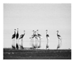
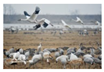
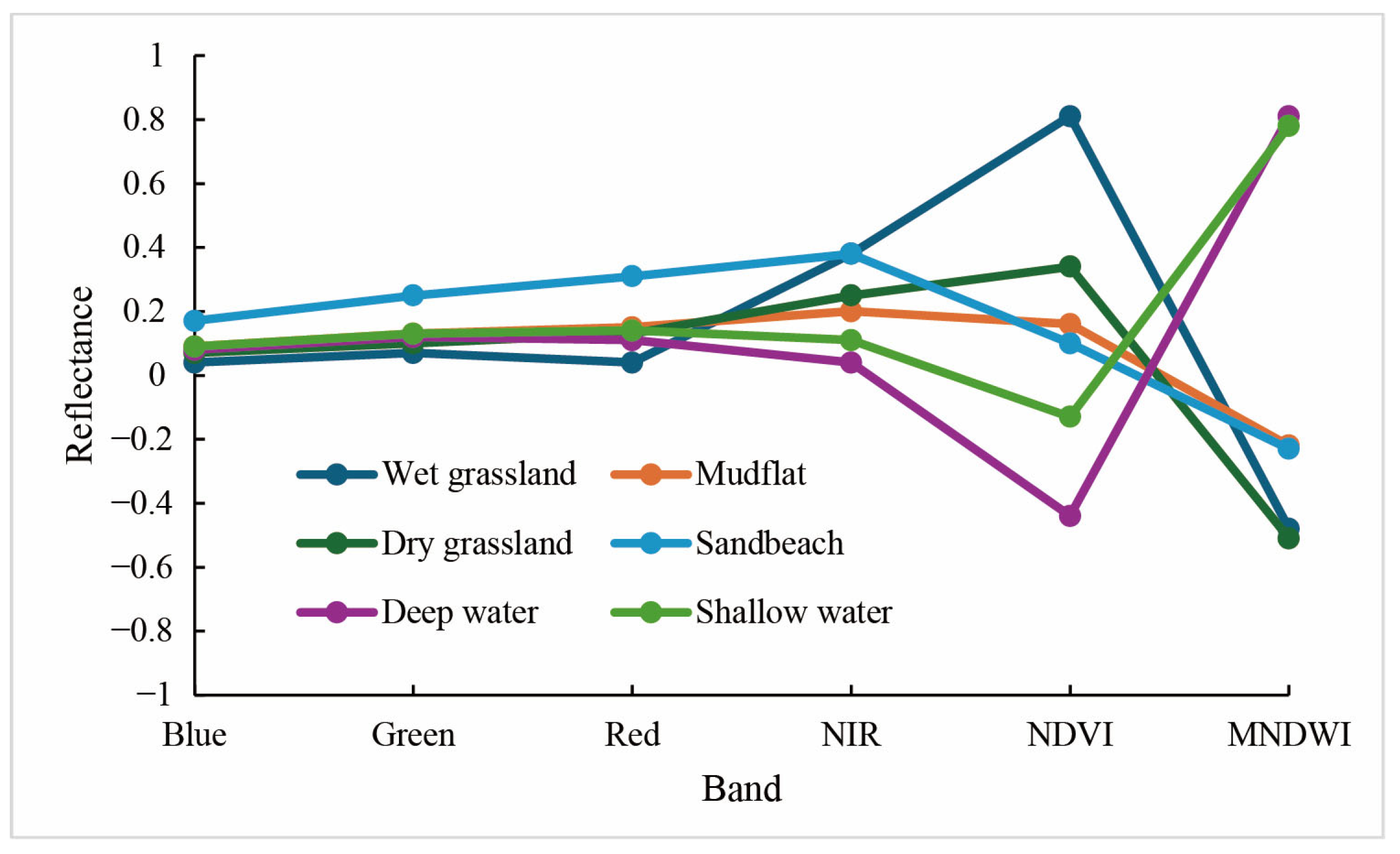
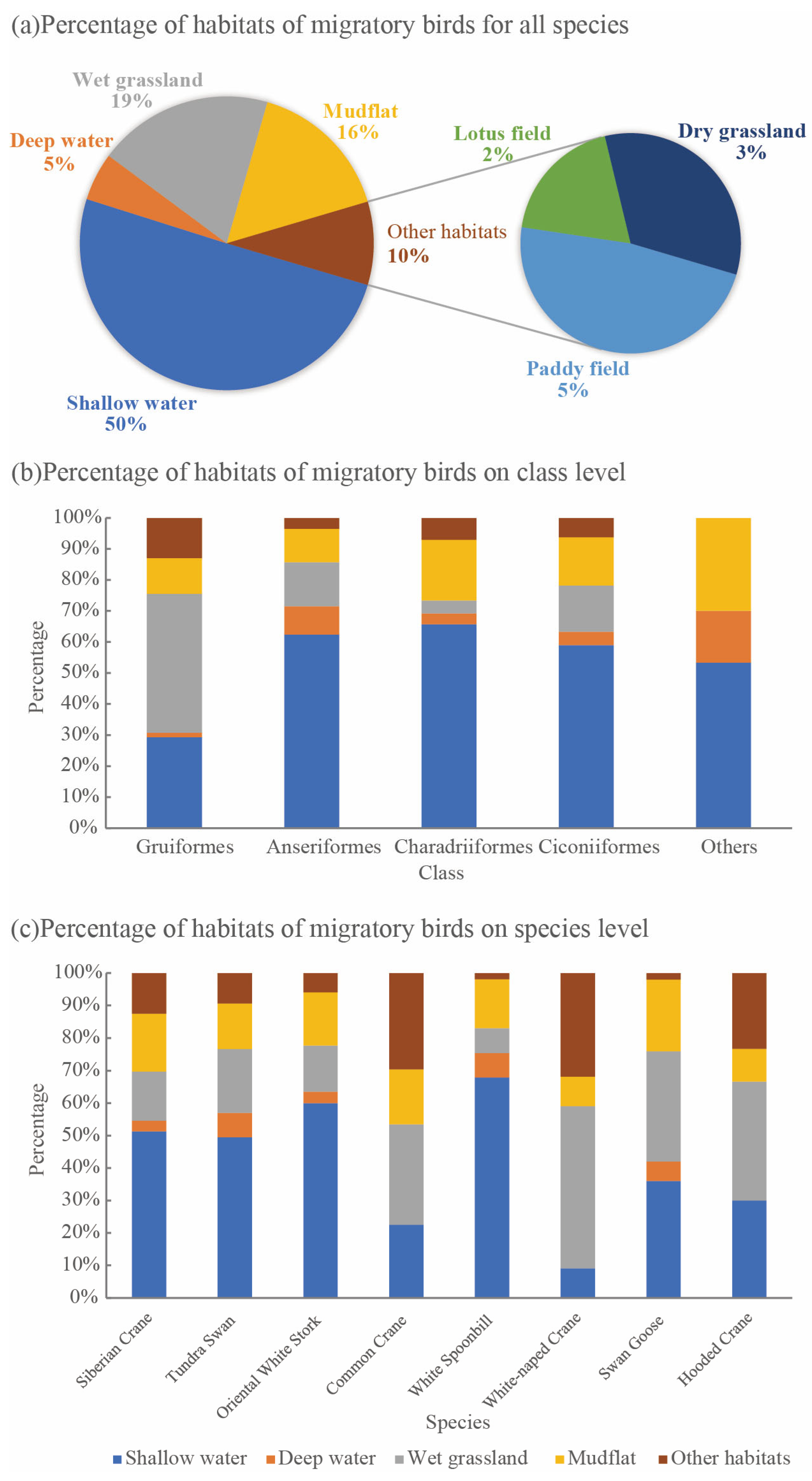
Through meticulous quantitative analysis, this research dissects the diverse habitat typologies crucial to migratory birds, shedding light on species-specific habitat predilections hitherto unexplored. Consistent with the results of previous studies [53], shallow water plays the most crucial role in the habitat of wintering migratory birds, partly because of the relatively abundant food resources [54]. This study quantifies the preference differences of various wintering migratory birds in Poyang Lake from the perspective of crowdsourced geographic information for the first time. As mentioned in Section 3.1, wet grasslands are the favorite habitat of White-naped cranes. Compared with the Siberian crane, which prefers shallow water, the ecological niche of the White-naped crane avoids intense resource competition between the two [55,56]. Therefore, the habitat preferences of wintering migratory birds need to be evaluated more comprehensively, so as to provide a better theoretical reference for the protection of migratory birds.

4.2. The Influence of Water Level on Habitats of Migratory Birds

Numerous studies have corroborated the profound influence of water level fluctuations on the wetland ecosystem, with Wu et al. [52] being a case in point, evidencing this crucial hydrological control mechanism. The cyclical dance between seasonal inundations and droughts orchestrates a rich tapestry of wetland habitats and bolsters ecosystem productivity, as exemplified by the floodplains surrounding Poyang Lake. This natural rhythm, however, can be disrupted by excessive water level variations, such as those induced by unprecedented flood peaks or severe drought conditions, which pose formidable challenges to the structural integrity and functional resilience of these ecosystems.
Empirical evidence underscores the heightened vulnerability of wetland vegetation under the dual stresses of post-flood droughts and extreme flooding events. Such disturbances not only compromise the vegetative fabric but also undermine the habitat functionality essential for sustaining migratory bird populations. This phenomenon is echoed in observations from two of the largest freshwater lakes in China, where Hong et al. [10] and Wu et al. [21] have documented similar detrimental impacts on avian habitats, highlighting the delicate balance within these ecosystems and the urgent need for effective water level management strategies to preserve their ecological services and biodiversity. Thus, understanding and mitigating the repercussions of extreme hydrological events are imperative for the conservation of wetland ecosystems and the myriad species they support.
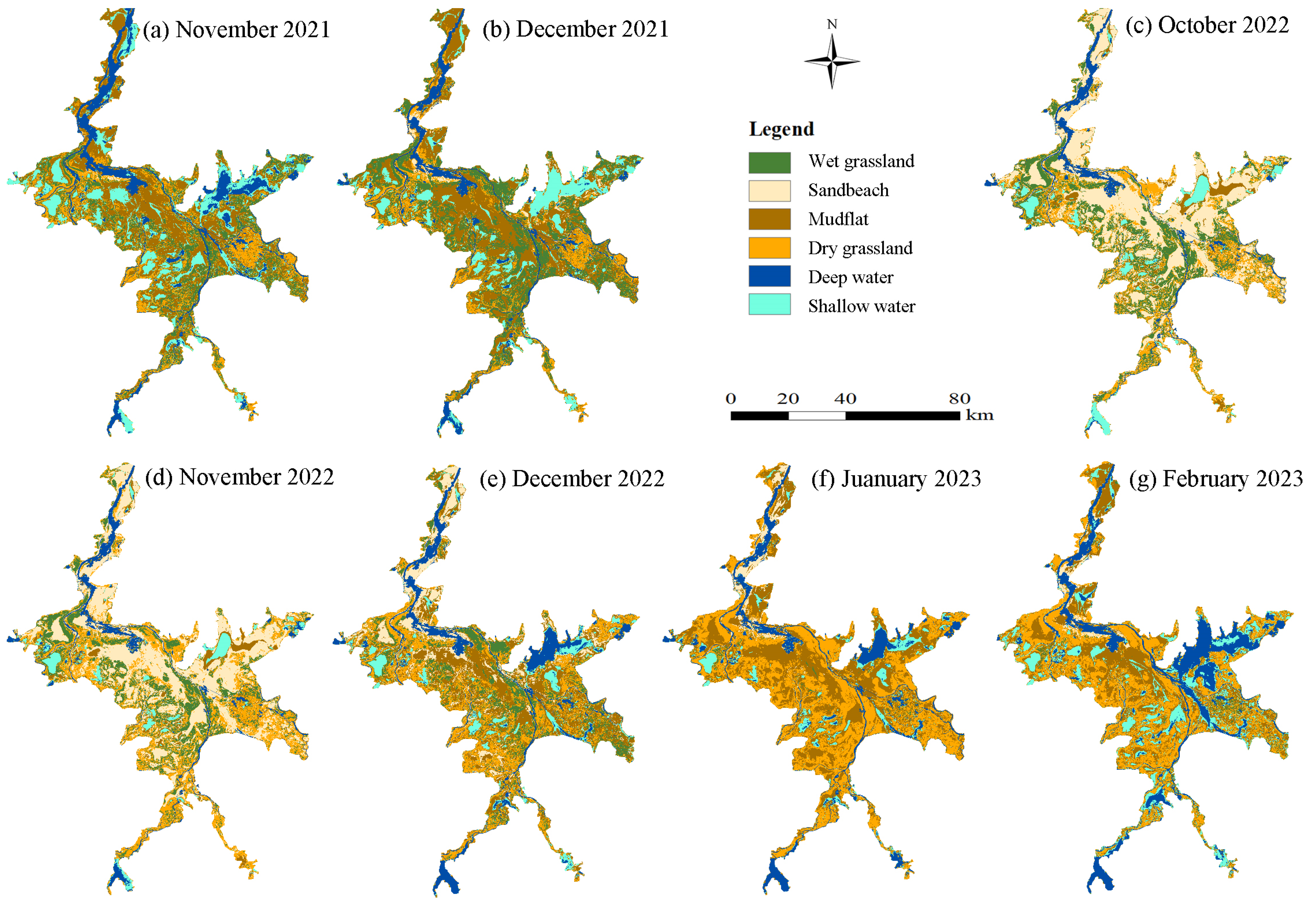
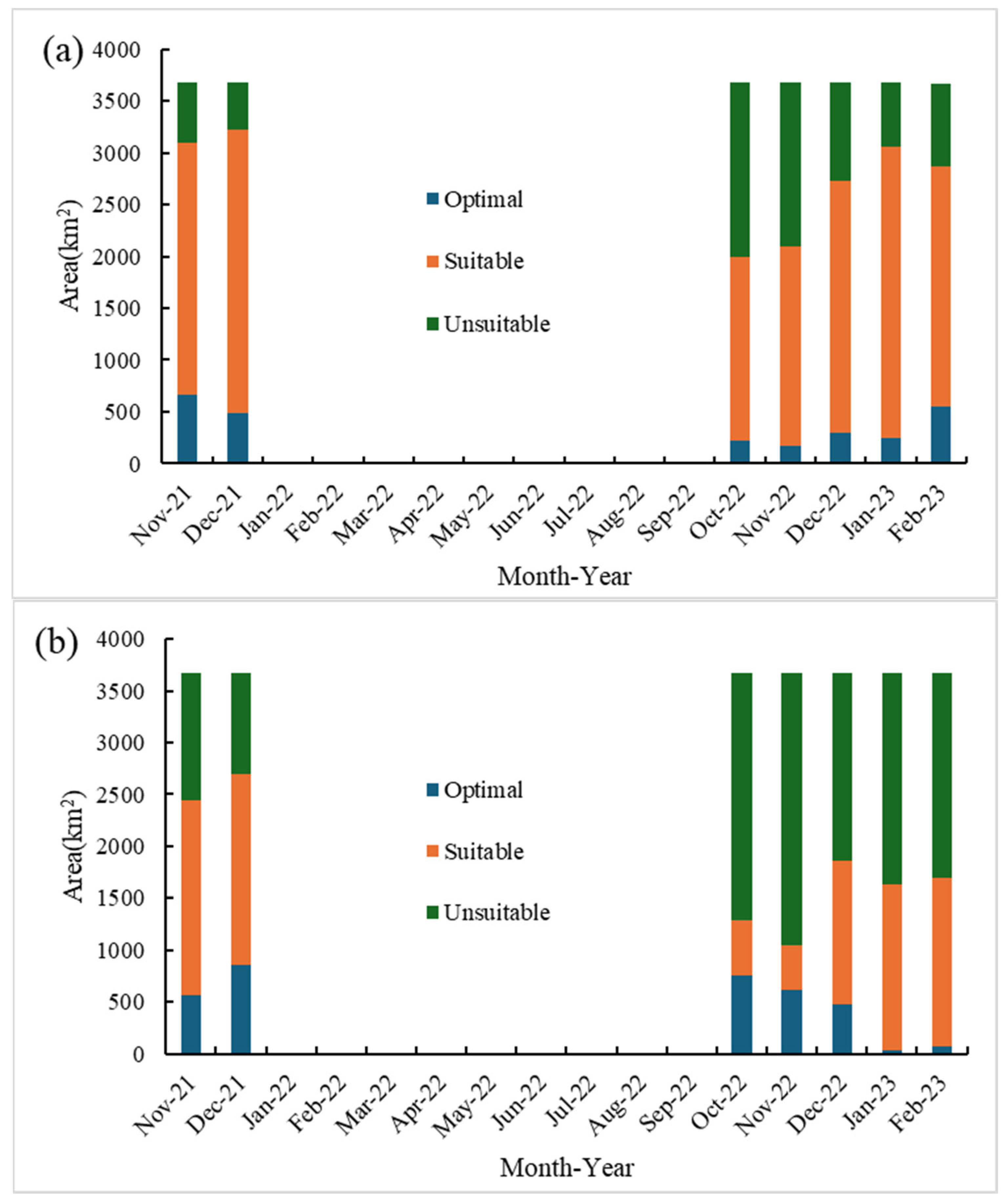
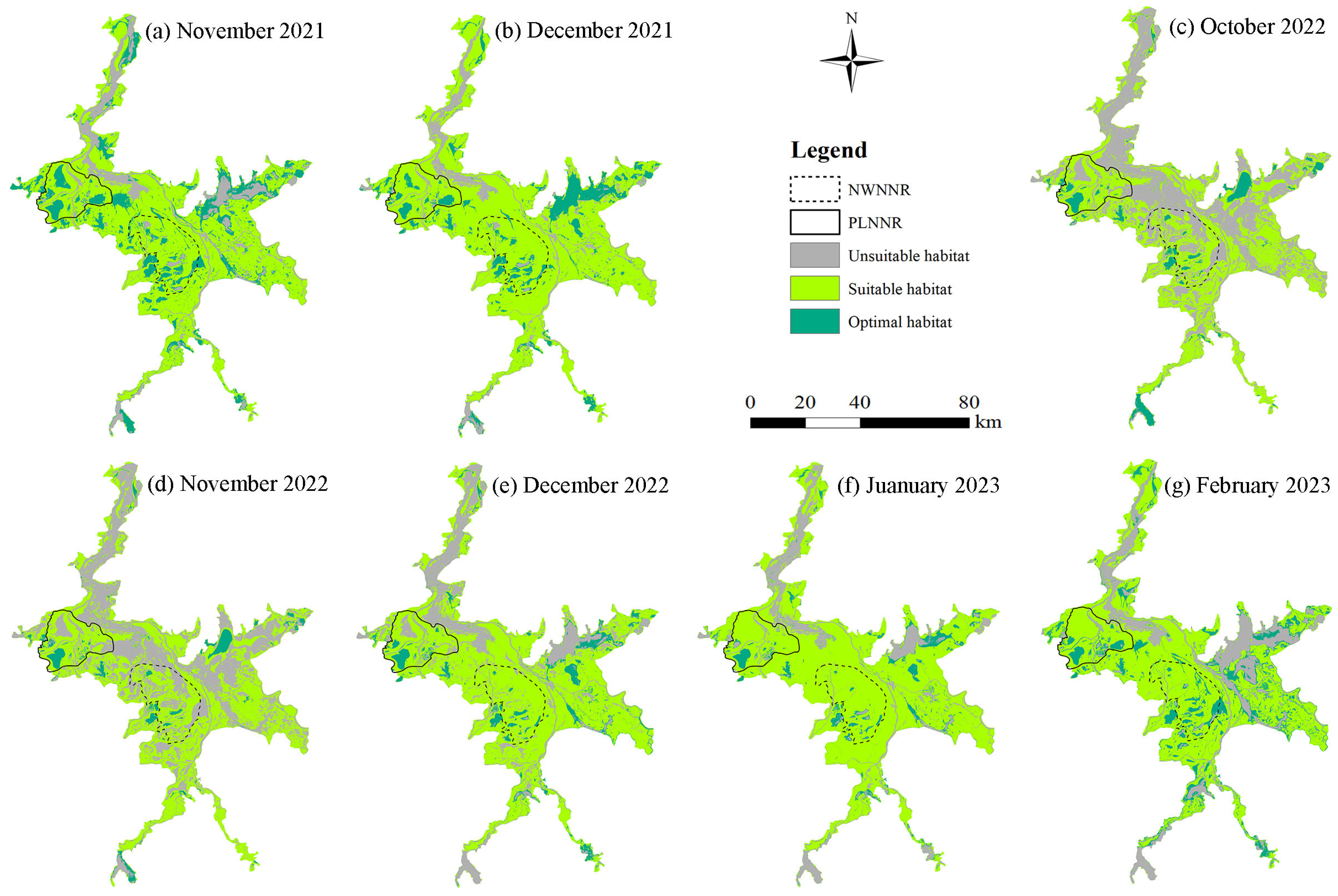
The repercussions of extreme drought phenomena on wetland ecosystems can have far-reaching implications for migratory bird populations, manifesting through disruptions in food chains and the degradation of vital habitats. Empirical evidence suggests that the Poyang Lake region, under severe water scarcity conditions, such as those observed in 2022, experiences a notable decline in migratory bird numbers [7,52]. This study’s findings reveal that, compared to average hydrological years, the wintering period during extreme drought years witnesses an expansive distribution of unsuitable habitats for migratory birds across Poyang Lake, with the area deemed most conducive for these avian species contracting by approximately 60%.
Extreme drought conditions exert dual pressures on the ecosystem. Firstly, they induce stress on wetland plants and submerged vegetation, impeding their growth and thereby jeopardizing the food availability essential for herbivorous migratory birds [10]. Secondly, these arid conditions precipitate the emergence of numerous desiccated shorelines within lakes, which in turn constricts the living spaces available for benthic organisms and fish populations [4]. Consequently, this ecological crunch leads to a dramatic reduction in suitable habitat areas for migratory birds, exacerbating the challenges faced by these species in their already precarious migratory journeys. These findings underscore the critical need for effective water resource management and conservation strategies to mitigate the impacts of extreme droughts on wetland ecosystems and safeguard the biodiversity they sustain.
Extreme drought has led to the damage of the structure and function of the lake wetland ecosystem [57,58], thereby affecting the suitability of the wintering migratory bird habitat. An important finding of this study is that the impact of extreme drought on the suitability of migratory bird habitats is not the same, which depends on the preferences of migratory bird habitats. As shown in Section 3.2 and Section 3.3, the extreme drought in 2022 led to a sharp shrinkage in shallow water, but the area of mudflats and dry grasslands increased to a certain extent, thereby affecting the change in the suitable area for migratory bird habitats. For most migratory birds represented by the Siberian crane, the suitable habitat types are shallow water, grassland and mudflats. However, the most suitable habitat type for the White-naped crane is wet grassland, followed by mudflats and shallow water. Therefore, the adverse impact of the extreme drought in 2022 on the White-naped crane was more significant than that on the Siberian crane. The main reason among them is that extreme drought causes the wetland vegetation to wither under water stress [59,60], and it is difficult to recover in a short time.
It is pivotal to acknowledge the disproportionate significance of sub-lakes as refugia for migratory bird habitats amid extreme drought conditions. These sub-lakes, the integral components of Poyang Lake’s geomorphology, owe their existence to the dynamic interplay between fluctuating flood and drought cycles and the protracted imprint of local anthropogenic activities [5,6,7]. During the flood season, these subsidiary bodies of water merge with the lake’s expanse, facilitating the migration and reproductive processes of fish populations. Conversely, in the aridity of the dry season, they sever superficial hydrological ties with Poyang Lake’s primary basin, thereby crystallizing into discrete wetland ecosystems. Empirical research underscores the critical role that these secluded aquatic environments play in harboring a diverse array of migratory bird species, effectively serving as oases amid the parched landscapes [5]. This underscores the imperative for conservation strategies targeting these ephemeral wetlands, particularly in the face of escalating drought frequencies and intensities, to preserve the ecological integrity and biodiversity they uphold.
Nonetheless, the prolonged persistence of low water levels exerts detrimental effects on the ecological fabric of sub-lake wetlands, albeit the delineation of a threshold for these repercussions remains an avenue for further scientific inquiry. The global ubiquity of similar small water body ecosystems, such as those observed in the Tonle Sap floodplains of the Mekong River [61] and Lake Curuai within the Amazonian basin [62], underscores their ecological significance. Empirical evidence has illuminated the disproportionately high aquatic biodiversity fostered by floodplain sub-lakes in comparison to both riverine and lacustrine counterparts [63], positioning them as biodiversity hotspots.
These diminutive aquatic enclaves, given their propensity to serve as refugia for organisms amid environmental upheavals, warrant heightened attention within the realms of wetland rehabilitation and sustainable management paradigms [5]. Recognizing their pivotal role in preserving biodiversity and facilitating ecological resilience, it becomes imperative to integrate strategies that safeguard these ephemeral ecosystems against the backdrop of a rapidly changing climate. Due to the length of the time series and the data volume limitations of crowdsourcing geographic information, this paper has not yet established a quantitative model to reveal the influence of extreme drought on migratory bird habitats. The integration of multi-source remote-sensing data, such as the Sentinel satellite series and the Landsat satellite series, is expected to expand the research scale within the framework of this paper, thereby establishing remote-sensing or weather-driven models and providing a scientific basis for the prediction and protection of migratory bird habitats in the future. Moreover, future research endeavors should thus focus on unraveling the specific mechanisms through which sub-lakes confer refugia status, as well as identifying management practices that can augment their resilience in the face of hydrological unpredictability.

4.3. Limitations and Further Research

This study endeavors to illuminate the transformative impacts of extreme drought conditions on the habitat of migratory birds inhabiting the Poyang Lake wetland, employing an innovative fusion of crowdsourced geographic intelligence and remote-sensing imagery as its methodological cornerstone. The integration of crowdsourced geographical data stands as a distinctive departure from extant research endeavors centered on migratory avian habitats within this vital ecosystem, underscoring our contention that such citizen-generated information harbors immense untapped potential for refining habitat suitability assessments.
Empirical outcomes corroborate the efficacy of this hybrid approach in yielding insights into migratory bird habitat dynamics, thereby validating its utility. Nevertheless, we acknowledge the inherent limitations within our methodology; notably, the coarse granularity of geographic data sourced from crowds complicates precise cartographic representation [35], thereby imposing constraints on deeper analytical explorations of avian habitat intricacies. Occurrence frequency is a key indicator for evaluating the suitability of migratory bird habitats using crowdsourced geographic information in this paper. Its important prerequisite is that the higher the occurrence frequency of a certain habitat of migratory birds in crowdsourced geographic information, the higher the suitability of this habitat. Its deficiency is the lack of verification of the number of species. Meanwhile, news media reports may tend to focus on well-known species [34], which need to be further explored in future studies.
For the public, due to the limited observation range, birds can usually only be observed at the bird-watching platforms or partially open areas of tourist attractions in Poyang Lake. The survey of overwintering waterbirds in Poyang Lake is conducted regularly every winter by the Wildlife Protection Administration of Jiangxi Province [64]. Some of the data from the migratory bird survey are released through the WeChat official account platform. These data constitute the main source of crowdsourced geographic data of migratory bird habitat used in this study. Previous literature has reported the quantities and changes of monitoring wintering migratory birds [64]. Therefore, by combining the migratory bird information released by the Wildlife Protection Administration, the spatial representativeness of the dataset can be improved to a certain extent. However, it is undeniable that there are geographical biases in crowdsourced geographic information. Even specialized researchers cannot achieve migratory bird observations in all geographical locations. Therefore, it is necessary to further explore how the spatial representativeness of crowdsourced geographic information affects the research results in future research.
Future prospects of migratory bird habitat conservation and the sustainable management of wetland ecosystems necessitate innovative strategies. In light of this, we advocate for the design and implementation of public science initiatives revolving around migratory bird habitat preservation. Such endeavors not only promise to enrich research methodologies but also serve as catalysts for enhancing public engagement and stewardship toward avian conservation. A pivotal component of this strategy involves rigorous monitoring of ecological and hydrological processes within representative sub-lake systems, with a keen eye on identifying critical lake level thresholds that exert discernible influences on sub-lake wetland ecologies. This knowledge is instrumental in fortifying the ecological resilience of both individual sub-lakes and the broader Poyang Lake wetland complex, thereby contributing to the long-term sustainability of these precious ecosystems.

5. Conclusions

Extreme drought undeniably exerts a profound impact on the ecological environment of the middle and lower Yangtze River basin. This study employed a multi-faceted approach, leveraging multi-source geographic information and Sentinel-2 remote-sensing imagery, to meticulously analyze the habitat dynamics of migratory avifauna and their adaptive responses to extreme drought events. The research validated the efficacy of utilizing media-reported geographic data in deciphering the habitat traits of migratory birds, thereby illuminating the transformative impacts of drought on the Poyang Lake wetland landscape during exceptionally arid years.
A distinctive feature of this investigation lies in its crowdsourced geographical information methodology, which facilitated the derivation of species-specific habitat preference ratios. Notably, Siberian crane exhibited a marked affinity for habitats comprising approximately 50% shallow water and 20% mudflats, whereas the White-naped crane’s preferred habitat constituted a mere 10% shallow water and an equally modest 10% mudflats. The findings underscore the general suitability of shallow waters, mudflats and grasslands as conducive habitat types for the majority of migratory bird species.
The extreme drought precipitated a staggering 60% reduction in the shallow water expanse of Poyang Lake, instigating a mass conversion of aquatic zones into mudflats and the desiccation of wet grasslands into arid ones. Consequently, the optimal habitat realm for migratory birds contracted significantly, becoming predominantly confined to a handful of sub-lake ecosystems. This contraction not only diminished the available suitable habitat but also exacerbated habitat fragmentation, posing substantial challenges to avian conservation.
Crucially, the research posits that sub-lakes may serve as critical refugia for migratory birds during the winter months under extreme drought conditions, emphasizing their paramount importance in conservation strategies. Building upon these insights, the study advocates for an intensified application of crowdsourced geographic information in the preservation efforts of migratory birds. Furthermore, it underscores the necessity of implementing targeted eco-hydrological monitoring programs within selected sub-lake ecosystems. Such endeavors are poised to deepen our comprehension of migratory bird conservation intricacies and inform sustainable wetland management practices, ultimately fostering resilience against the backdrop of a changing climate.

Author Contributions

X.L.: Conceptualization, writing—original draft, writing—review and editing; L.Y.: Methodology, data curation, writing—original draft; Z.L.: Methodology, writing—original draft preparation; Y.H.: Data curation, formal analysis; Y.L.: Visualization. All authors have read and agreed to the published version of the manuscript.

Funding

This research was funded by the National Natural Science Foundation of China (42207087) and Jiangxi Provincial Natural Science Foundation (20232BAB213056).

Data Availability Statement

The remote-sensing datasets analyzed in this study can be found on Copernicus Open Access Hub. Further inquiries about the data can be directed to the corresponding author.

Conflicts of Interest

The authors declare no conflicts of interest.

References

  1. Fluet-Chouinard, E.; Stocker, B.D.; Zhang, Z.; Malhotra, A.; Melton, J.R.; Poulter, B.; Kaplan, J.O.; Goldewijk, K.K.; Siebert, S.; Minayeva, T.; et al. Extensive global wetland loss over the past three centuries. Nature 2023, 614, 281–286. [Google Scholar] [CrossRef]
  2. Qu, Y.; Gong, H.; Zheng, Y.; Shi, J.; Zeng, X.; Yang, H.; Wang, J.; Niu, Z.; Li, L.; Wang, S.; et al. Global conservation priorities for wetlands and setting post-2025 targets. Commun. Earth Environ. 2024, 5, 4. [Google Scholar] [CrossRef]
  3. Zhang, J.; Li, X.; Batbayar, N.; Xu, Z.; Cao, L.; Fox, A.D. Exploring potential reasons for the increase in the East Asian Greylag Goose Anser anser population by assessing habitat use and use of protected areas. Bird Conserv. Int. 2022, 33, e22. [Google Scholar] [CrossRef]
  4. Zhang, P.; Zhang, S.; Zou, Y.; Wu, T.; Li, F.; Deng, Z.; Zhang, H.; Song, Y.; Xie, Y. Integrating suitable habitat dynamics under typical hydrological regimes as guides for the conservation and restoration of different waterbird groups. J. Environ. Manag. 2023, 345, 118451. [Google Scholar] [CrossRef] [PubMed]
  5. Lu, M.; Zhang, Z.; Chen, P.; Xu, C.; Gao, B.; Ruan, L. Shallow sub-lakes are essential for sustaining the successful wintering of waterbirds in Poyang Lake, China. Avian Res. 2024, 15, 100178. [Google Scholar] [CrossRef]
  6. Xia, S.; Liu, Y.; Wang, Y.; Chen, B.; Jia, Y.; Liu, G.; Yu, X.; Wen, L. Wintering waterbirds in a large river floodplain: Hydrological connectivity is the key for reconciling development and conservation. Sci. Total Environ. 2016, 573, 645–660. [Google Scholar] [CrossRef]
  7. Wang, C.; Xia, S.; Yu, X.; Wen, L. Timing mowing for maximal energy gain-Managing foraging habitat of wintering geese under extreme drought conditions. J. Environ. Manag. 2024, 370, 122360. [Google Scholar] [CrossRef]
  8. Shi, L.; Jia, Y.; Zuo, A.; Ma, T.; Lei, J.; Lei, G.; Wen, L. Dynamic change of vegetation cover and productivity of Poyang Lake wetland based on MODIS EVI time series. Biodivers. Sci. 2018, 26, 828–837. [Google Scholar] [CrossRef]
  9. Zeng, J.; Qiu, J.; Wu, Z.; Liu, X.; Li, Y. Impact of the Three Gorges Dam on hydrological connectivity and vegetation growth of Poyang Lake floodplain, China. J. Hydrol. 2024, 631, 130831. [Google Scholar] [CrossRef]
  10. Hong, G.; Xie, X.; Tan, C.; Liang, S.; Hu, X.; Wu, X. Assessment of vegetation vulnerability in floodplain wetlands: A perspective from carryover effect of seasonal growth under various extreme hydrological scenarios. J. Hydrol. 2025, 651, 132622. [Google Scholar] [CrossRef]
  11. Xu, F.; Liu, G.; Si, Y. Local temperature and El Nino Southern Oscillation influence migration phenology of East Asian migratory waterbirds wintering in Poyang, China. Integr. Zool. 2017, 12, 303–317. [Google Scholar] [CrossRef]
  12. Wang, Y.-S.; Gu, J.-D. Ecological responses, adaptation and mechanisms of mangrove wetland ecosystem to global climate change and anthropogenic activities. Int. Biodeterior. Biodegrad. 2021, 162, 105248. [Google Scholar] [CrossRef]
  13. Song, A.; Liang, S.; Li, H.; Yan, B. Effects of biodiversity on functional stability of freshwater wetlands: A systematic review. Front. Microbiol. 2024, 15, 1397683. [Google Scholar] [CrossRef]
  14. Feng, L.; Shi, J.; Xiao, Y.; Liao, L.; Zhou, Z.; Xu, J.; Li, Y.; Tian, Y.; Niu, Y. Impact of Extreme Drought on Waterbird Abundance: A Case Study Based on the Core Nature Reserve and Surrounding Wetlands. Ecol. Evol. 2025, 15, e71258. [Google Scholar] [CrossRef] [PubMed]
  15. Yao, S.; Li, X.; Liu, C.; Zhang, J.; Li, Y.; Gan, T.; Liu, B.; Kuang, W. New assessment indicator of habitat suitability for migratory bird in wetland based on hydrodynamic model and vegetation growth threshold. Ecol. Indic. 2020, 117, 106556. [Google Scholar] [CrossRef]
  16. Han, H.; Jian, H.; Liu, M.; Lei, S.; Yao, S.; Yan, F. Impacts of drought and heat events on vegetative growth in a typical humid zone of the middle and lower reaches of the Yangtze River, China. J. Hydrol. 2023, 620, 129452. [Google Scholar] [CrossRef]
  17. Teng, J.; Xia, S.; Liu, Y.; Duan, H.; Yu, X.; Chen, J. An integrated model for prediction of hydrologic anomalies for habitat suitability of overwintering geese in a large floodplain wetland, China. J. Environ. Manag. 2023, 331, 117239. [Google Scholar] [CrossRef] [PubMed]
  18. Hu, Z. Serious drought in Poyang Lake in 2022 and countermeasures for drought prevention and disaster reduction. China Flood Drought Manag. 2023, 33, 1–6+39. [Google Scholar] [CrossRef]
  19. Chen, J.; Li, Y.; Shu, L.; Fang, S.; Yao, J.; Cao, S.; Zeng, B.; Yang, M. The influence of the 2022 extreme drought on groundwater hydrodynamics in the floodplain wetland of Poyang Lake using a modeling assessment. J. Hydrol. 2023, 626, 130194. [Google Scholar] [CrossRef]
  20. Zhang, Q.; Xue, C.; Xia, J. Impacts, contributing factors and countermeasures of extreme droughts in Poyang Lake. Bull. Chin. Acad. Sci. 2023, 38, 1894–1902. [Google Scholar] [CrossRef]
  21. Wu, H.; Dai, J.; Sun, S.; Du, C.; Long, Y.; Chen, H.; Yu, G.; Ye, S.; Chen, J. Responses of habitat suitability for migratory birds to increased water level during middle of dry season in the two largest freshwater lake wetlands of China. Ecol. Indic. 2021, 121, 107065. [Google Scholar] [CrossRef]
  22. Hirzel, A.H.; Le Lay, G.; Helfer, V.; Randin, C.; Guisan, A. Evaluating the ability of habitat suitability models to predict species presences. Ecol. Model. 2006, 199, 142–152. [Google Scholar] [CrossRef]
  23. Dong, Z.; Wang, Z.; Liu, D.; Li, L.; Ren, C.; Tang, X.; Jia, M.; Liu, C. Assessment of habitat suitability for waterbirds in the West Songnen Plain, China, using remote sensing and GIS. Ecol. Eng. 2013, 55, 94–100. [Google Scholar] [CrossRef]
  24. Deutsch, C.; Bilenca, D.N.; Zurano, J.P.; da Fonte, L.F.M.; Vargas, N.D.; Kindel, A.; Pittella, R.; Freire, M.D.; Maneyroh, R.; Faivovichi, J.; et al. Habitat loss and distribution of the Ornate Horned Frog (Ceratophrys ornata): Implications for its conservation in South American temperate grasslands. Perspect. Ecol. Conserv. 2024, 22, 35–42. [Google Scholar] [CrossRef]
  25. Liu, Y.; Shi, J.; Jin, R.; Zhu, W.; Guo, Y.; Guo, B.; Wang, X.; Wang, J.; Xia, X. Evaluating waterbird migratory stopover habitat suitability in the Tumen River Estuary at the junction of China, North Korea and Russia using multi-source remote sensing imagery. J. Environ. Manag. 2024, 370, 122999. [Google Scholar] [CrossRef] [PubMed]
  26. He, K.; Fan, C.; Zhong, M.; Cao, F.; Wang, G.; Cao, L. Evaluation of Habitat Suitability for Asian Elephants in Sipsongpanna under Climate Change by Coupling Multi-Source Remote Sensing Products with MaxEnt Model. Remote Sens. 2023, 15, 1047. [Google Scholar] [CrossRef]
  27. Huang, T.; Yang, T.; Wang, K.; Huang, W. Assessing the Current and Future Potential Distribution of Solanum rostratum Dunal in China Using Multisource Remote Sensing Data and Principal Component Analysis. Remote Sens. 2024, 16, 271. [Google Scholar] [CrossRef]
  28. Sousa, L.B.; Fricker, S.R.; Doherty, S.S.; Webb, C.E.; Baldock, K.L.; Williams, C.R. Citizen science and smartphone e-entomology enables low-cost upscaling of mosquito surveillance. Sci. Total Environ. 2020, 704, 135349. [Google Scholar] [CrossRef]
  29. Stern, E.R.; Humphries, M.M. Interweaving local, expert, and Indigenous knowledge into quantitative wildlife analyses: A systematic review. Biol. Conserv. 2022, 266, 109444. [Google Scholar] [CrossRef]
  30. Sgroi, G.; D’Alessio, N.; Vada, R.; Ferroglio, E.; Vicente, J.; Veneziano, V. The contribution of citizen science in the surveillance of wildlife and related arthropods. Parasitology 2023, 150, 1089–1095. [Google Scholar] [CrossRef]
  31. Wen, F.; Lu, L.; Nie, C.; Sun, Z.; Liu, R.; Huang, W.; Ye, H. Analysis of Spatiotemporal Variation in Habitat Suitability for Oedaleus decorus asiaticus Bei-Bienko on the Mongolian Plateau Using Maxent and Multi-Source Remote Sensing Data. Insects 2023, 14, 492. [Google Scholar] [CrossRef] [PubMed]
  32. Karasov, O.; Heremans, S.; Külvik, M.; Domnich, A.; Burdun, I.; Kull, A.; Helm, A.; Uuemaa, E. Beyond land cover: How integrated remote sensing and social media data analysis facilitates assessment of cultural ecosystem services. Ecosyst. Serv. 2022, 53, 101391. [Google Scholar] [CrossRef]
  33. Nyelele, C.; Keske, C.; Chung, M.G.; Guo, H.; Egoh, B.N. Using social media data and machine learning to map recreational ecosystem services. Ecol. Indic. 2023, 154, 110606. [Google Scholar] [CrossRef]
  34. Stephenson, N.; Pettorelli, N.; Early, R. Occupancy of Urban Habitats by the Jersey Tiger Moth Is Revealed by Social Media Data but Not Traditional Monitoring. Ecol. Evol. 2025, 15, e71086. [Google Scholar] [CrossRef]
  35. O’Neill, D.; Häkkinen, H.; Neumann, J.; Shaffrey, L.; Cheffings, C.; Norris, K.; Pettorelli, N. Investigating the potential of social media and citizen science data to track changes in species’ distributions. Ecol. Evol. 2023, 13, e10063. [Google Scholar] [CrossRef]
  36. Wang, G.; Wu, H.; Dai, J.; Xiong, Y.; Long, Y.; Cai, X.; Mo, S.; Yang, R.; Liu, Y. Priorities identification of habitat restoration for migratory birds under the increased water level during the middle of dry season: A case study of Poyang Lake and Dongting Lake wetlands, China. Ecol. Indic. 2023, 151, 110322. [Google Scholar] [CrossRef]
  37. Zhu, Y.W.; Wang, H.X.; Guo, W.X. The impacts of water level fluctuations of East Dongting Lake on habitat suitability of migratory birds. Ecol. Indic. 2021, 132, 108277. [Google Scholar] [CrossRef]
  38. Peng, Y.; Chen, G.; Chao, N.; Wang, Z.; Wu, T.; Luo, X. Detection of extreme hydrological droughts in the Poyang lake basin during 2021-2022 using GNSS-derived daily terrestrial water storage anomalies. Sci. Total Environ. 2024, 919, 170875. [Google Scholar] [CrossRef]
  39. Feng, L.; Hu, C.; Chen, X.; Cai, X.; Tian, L.; Gan, W. Assessment of inundation changes of Poyang Lake using MODIS observations between 2000 and 2010. Remote Sens. Environ. 2012, 121, 80–92. [Google Scholar] [CrossRef]
  40. Wu, X.; Lv, M.; Jin, Z.; Michishita, R.; Chen, J.; Tian, H.; Tu, X.; Zhao, H.; Niu, Z.; Chen, X.; et al. Normalized difference vegetation index dynamic and spatiotemporal distribution of migratory birds in the Poyang Lake wetland, China. Ecol. Indic. 2014, 47, 219–230. [Google Scholar] [CrossRef]
  41. Xu, H.; Dong, B.; Gao, X.; Xu, Z.; Ren, C.; Fang, L.; Wei, Z.; Liu, X.; Lu, Z. Habitat quality assessment of wintering migratory birds in Poyang Lake National Nature Reserve based on InVEST model. Environ. Sci. Pollut. Res. Int. 2023, 30, 28847–28862. [Google Scholar] [CrossRef] [PubMed]
  42. He, G.; Chen, Y.; Chen, B.; Wang, H.; Shen, L.; Liu, L.; Suolang, D.; Zhang, B.; Ju, G.; Zhang, L.; et al. Using the Baidu Search Index to Predict the Incidence of HIV/AIDS in China. Sci. Rep. 2018, 8, 9038. [Google Scholar] [CrossRef] [PubMed]
  43. Xing, Z.; Zhang, X.; Zan, X.; Xiao, C.; Li, B.; Han, K.; Liu, Z.; Liu, J. Crowdsourced social media and mobile phone signaling data for disaster impact assessment: A case study of the 8.8 Jiuzhaigou earthquake. Int. J. Disaster Risk Reduct. 2021, 58, 102200. [Google Scholar] [CrossRef]
  44. Yu, F.; Zhai, J.; Huang, Z.; Chen, J.; Han, F.; Wang, L. The impact of Poyang Lake water level changes on the landscape pattern of wintering wading bird habitats. Glob. Ecol. Conserv. 2025, 58, e03453. [Google Scholar] [CrossRef]
  45. Zhao, H.; Wang, Y.; Xu, B.; Chen, X.; Jiang, Z. Exploring an efficient habitat index for predicting population and abundance of migratory birds in Poyang Lake Wetland, South China. Acta Ecol. Sin. 2018, 38, 381–390. [Google Scholar] [CrossRef]
  46. Shao, M.; Wang, J.; Ding, H.; Yang, F. Response of Siberian Cranes (Grus leucogeranus) to Hydrological Changes and the Availability of Foraging Habitat at Various Water Levels in Poyang Lake. Animals 2024, 14, 234. [Google Scholar] [CrossRef]
  47. Turissa, P.; Nababan, B.; Siregar, V.P.; Kushardono, D.; Madduppa, H.H.; Nandika, M.R.; Firmansyah, S. Sentinel-2A multispectral image analysis for seagrass mapping in Bintan’s shallow water ecosystem: A case study of Teluk Bakau, Malang Rapat, and Berakit villages. Kuwait J. Sci. 2024, 51, 100286. [Google Scholar] [CrossRef]
  48. Qiu, J.; Li, Y.; Liu, X. Assessment of the Impact of Extreme Hydrological Conditions on Migratory Bird Habitats of the Largest Freshwater Lake Wetlands in China Based on Multi-Source Remote Sensing Fusion Approach. Sustainability 2025, 17, 1900. [Google Scholar] [CrossRef]
  49. Liu, S.; Wu, Y.; Xu, G.; Cheng, S.; Zhong, Y.; Zhang, Y. Characterizing the 2022 Extreme Drought Event over the Poyang Lake Basin Using Multiple Satellite Remote Sensing Observations and In Situ Data. Remote Sens. 2023, 15, 5125. [Google Scholar] [CrossRef]
  50. Ostermann-Miyashita, E.-F.; Pernat, N.; Koenig, H.J. Citizen science as a bottom-up approach to address human-wildlife conflicts: From theories and methods to practical implications. Conserv. Sci. Pract. 2021, 3, e385. [Google Scholar] [CrossRef]
  51. Kallimanis, A.S.; Panitsa, M.; Dimopoulos, P. Quality of non-expert citizen science data collected for habitat type conservation status assessment in Natura 2000 protected areas. Sci. Rep. 2017, 7, 8873. [Google Scholar] [CrossRef] [PubMed]
  52. Wu, H.; Hu, X.; Sun, S.; Dai, J.; Ye, S.; Du, C.; Chen, H.; Yu, G.; Zhou, L.; Chen, J. Effect of increasing of water level during the middle of dry season on landscape pattern of the two largest freshwater lakes of China. Ecol. Indic. 2020, 113, 106283. [Google Scholar] [CrossRef]
  53. Li, Y.; Dong, X.; Hu, C. The impact of ecological water level on wintering migratory birds in Poyang Lake—Focusing on phytophagous geese. Ecol. Indic. 2024, 169, 112946. [Google Scholar] [CrossRef]
  54. Hou, J.; Liu, Y.; Fraser, J.D.; Li, L.; Zhao, B.; Lan, Z.; Jin, J.; Liu, G.; Dai, N.; Wang, W. Drivers of a habitat shift by critically endangered Siberian cranes: Evidence from long-term data. Ecol. Evol. 2020, 10, 11055–11068. [Google Scholar] [CrossRef] [PubMed]
  55. Xu, H.; Dong, B.; Xu, Z.; Ma, J.; Shen, F. Study on habitat suitability and ecological network of rare cranes in Poyang Lake National Nature Reserve. Ecol. Indic. 2025, 174, 113480. [Google Scholar] [CrossRef]
  56. Jia, Y.; Zhang, Y.; Lei, J.; Jiao, S.; Lei, G.; Yu, X.; Liu, G. Activity Patterns of four Cranes in Poyang Lake, China: Indication of Habitat Naturalness. Wetlands 2019, 39, S45–S53. [Google Scholar] [CrossRef]
  57. Xia, Y.; Liu, Y.; Wang, Z.; Huang, Z.; You, W.; Wu, Q.; Zhou, S.; Zou, J. Damage Inflicted by Extreme Drought on Poyang Lake Delta Wetland and the Establishment of Countermeasures. Water 2024, 16, 2292. [Google Scholar] [CrossRef]
  58. Lai, X.; Zeng, H.; Zhao, X.; Shao, Y.; Guo, X. Impact of Extreme Drought on Vegetation Greenness in Poyang Lake Wetland. Forests 2024, 15, 1756. [Google Scholar] [CrossRef]
  59. Xiong, Y.; Dai, Y.; Wu, H.; Liu, Y.; Wang, G.; Cai, X.; Zhou, L.; Zhou, N. Effects of extreme drought on landscape pattern of Dongting Lake wetland, China. Ecol. Indic. 2024, 169, 112974. [Google Scholar] [CrossRef]
  60. Zhang, W.; Luo, G.; Hamdi, R.; Ma, X.; Termonia, P.; De Maeyer, P. Drought changes the dominant water stress on the grassland and forest production in the northern hemisphere. Agric. For. Meteorol. 2024, 345, 109831. [Google Scholar] [CrossRef]
  61. Dang, H.; Pokhrel, Y.; Shin, S.; Stelly, J.; Ahlquist, D.; Du Bui, D. Hydrologic balance and inundation dynamics of Southeast Asia’s largest inland lake altered by hydropower dams in the Mekong River basin. Sci. Total Environ. 2022, 831, 154833. [Google Scholar] [CrossRef] [PubMed]
  62. Melack, J.M.; Coe, M.T. Amazon floodplain hydrology and implications for aquatic conservation. Aquat. Conserv. Mar. Freshw. Ecosyst. 2021, 31, 1029–1040. [Google Scholar] [CrossRef]
  63. Biggs, J.; von Fumetti, S.; Kelly-Quinn, M. The importance of small waterbodies for biodiversity and ecosystem services: Implications for policy makers. Hydrobiologia 2017, 793, 3–39. [Google Scholar] [CrossRef]
  64. Duan, H.; Pan, Y.; Yu, X.; Xia, S. Effects of Habitat Change on the Wintering Waterbird Community in China’s Largest Freshwater Lake. Remote Sens. 2023, 15, 4582. [Google Scholar] [CrossRef]
Figure 1. Study area map: (a) Location of Poyang Lake in the Yangtze River, (b) Poyang Lake wetlands during flood season with illustration of lake inflow from Poyang Lake catchment and outflow to the Yangtze River, (c) Poyang Lake wetlands during dry season. The blue arrow indicates the flow direction of rivers.
Land 14 01236 g001
Figure 2. The distribution of samples of remote-sensing images in November 2021.
Land 14 01236 g002
Figure 3. Spectral profiles of various samples for images in November 2021.
Land 14 01236 g003
Figure 4. Percentage of migratory birds occurrence in crowdsourced geographic data.
Land 14 01236 g004
Figure 5. Percentage of habitats of migratory birds summarized on crowdsourced geographic data.
Land 14 01236 g005
Figure 6. Classification of wetland landscape during the winter season of 2022 and 2021.
Land 14 01236 g006
Figure 7. Changes in the area of suitable habitats for wintering migratory birds: (a) Overall changes for all migratory birds, (b) Changes in the area of suitable habitats for White-naped cranes.
Land 14 01236 g007
Figure 8. Map of habitat suitability of migratory birds during the winter season of 2022 and 2021.
Land 14 01236 g008
Table 1. Examples of habitat records of migratory birds based on crowdsourced geographic data.
NumberMigratory BirdsReport DateHabitat TypeURL AddressPicture
1White Spoonbill3 December 2023Shallow waterhttps://baijiahao.baidu.com/s?id=1784221516987566462&wfr=spider&for=pc, accessed on 31 December 2023Land 14 01236 i001
2Hooded Crane31 March 2023Wet grasslandhttps://i.ifeng.com/c/8OaBfxxu0Db, accessed on 31 May 2023Land 14 01236 i002
3Tundra Swan28 February 2023Shallow waterhttps://www.163.com/dy/article/HUM4O1OO0530QRMB.html, accessed on 31 May 2023Land 14 01236 i003
4White-Naped Crane12 November 2022Mudflathttps://baijiahao.baidu.com/s?id=1751333381100108558&wfr=spider&for=pc, accessed on 31 May 2023Land 14 01236 i004
5Bean Goose10 October 2023Wet grasslandhttps://www.thepaper.cn/newsDetail_forward_24891597, accessed on 31 December 2023Land 14 01236 i005
6Oriental White Stork16 December 2022Shallow waterhttps://jx.cnr.cn/gstjjx/20221216/t20221216_526096090.shtml, accessed on 31 May 2023Land 14 01236 i006
7Black-Winged Stilt15 November 2021Shallow waterhttp://www.poyang.gov.cn/poyang/zirandili/202111/9dd734bef94c407f942d6d4673165ea0.shtml, accessed on 31 May 2023Land 14 01236 i007
8Siberian Crane8 January 2022Dry grasslandhttp://pic.people.com.cn/n1/2022/0109/c1016-32327226-2.html, accessed on 31 May 2023Land 14 01236 i008
9Swan Goose19 January 2023Shallow waterhttp://www.ftourcn.com/sf_20EAC02914174001BEA88070648A57F5_246_pyh.html, accessed on 31 May 2023Land 14 01236 i009
Table 2. Remote-sensing data selected for wetland classification.
Month of ImageData SourceCloud CoverSpatial ResolutionLake Water Level
2021-11Sentinel-2 MSI: Level-2A<20%10 m10.94 m
2021-12Sentinel-2 MSI: Level-2A<20%10 m7.39 m
2022-10Sentinel-2 MSI: Level-2A<20%10 m7.44 m
2022-11Sentinel-2 MSI: Level-2A<20%10 m6.8 m
2022-12Sentinel-2 MSI: Level-2A<20%10 m6.82 m
2023-01Sentinel-2 MSI: Level-2A<20%10 m7.24 m
2023-02Sentinel-2 MSI: Level-2A<20%10 m8.36 m
Table 3. Classification reference system of wetland landscape types in the study area.
Land CoverComposite BandsRepresentative ImagesColor and Spatial Distribution
Wet grasslandFalse Color Composite with band 8, 4, 3Land 14 01236 i010The color appear as bright red, mostly found near mudflats, with irregular shapes. They are mostly composed of migratory birds that feed on tubers.
MudflatFalse Color Composite with band 8, 4, 3Land 14 01236 i011The color appears grayish-brown and dim, mainly distributed near shallow waters, with traces of flowing water on the surface.
Dry grasslandFalse Color Composite with band 8, 4, 3Land 14 01236 i012The color shows an orange-copper color, mostly distributed near wet grasslands.
Sandy beachFalse Color Composite with band 8, 4, 3Land 14 01236 i013The color is bright, mostly distributed near river channels.
Deep waterFalse Color Composite with band 8, 4, 3Land 14 01236 i014The color is dark blue, mostly in river channels and main lakes, where large migratory birds prey on large fish.
Shallow waterFalse Color Composite with band 8, 4, 3Land 14 01236 i015The color is light, surrounded by mudflats, mostly sub-lakes, which are the habitats of the most migratory birds.
Table 4. The sample quantity of each satellite image.
Land CoverImage Month
Nov-21Dec-21Oct-22Nov-22Dec-22Jan-23Feb-23
Wet grassland129150142168122101132
Mudflat129126112102136216163
Dry grassland256176237251328308180
Sandy beach548316715117911268
Deep water1235994105126155130
Shallow water114717283132120145
Totals80566582486010231012818
Table 5. Accuracy evaluation of classification.
Image MonthOverall AccuracyKappa Coefficient
2021-110.950.94
2021-120.940.93
2022-100.910.89
2022-110.90.88
2022-120.920.91
2023-010.850.82
2023-020.850.82
Table 6. Statistics of the area of various wetland types (km2) and lake water level (m).
MonthWet Grassland (km2)Sandy Beach (km2)Mudflat (km2)Dry Grassland (km2)Deep Water (km2)Shallow Water (km2)Water Level (m)
November 2021570.114.81,217.4647.7566.8659.510.94
December 2021862.186.31346.5523.1371.5486.77.39
October 2022757.61397.9307.3712.9282.7217.87.44
November 2022619.81293.2255.21044.7292.3171.16.80
December 2022477.9472.01085.0875.9473.8291.76.82
January 202333.3137.21353.41426.3484.0242.07.24
February 202369.890.61072.81183.4705.8545.28.36
Table 7. Habitat suitability assessment from 2022 based on crowdsourced geospatial information.
Wetland ClassificationPercentage Based on Crowdsourced Geospatial Information (%)Habitat Suitability
Shallow water50Optimal habitat
Mudflat16Suitable habitat
Grassland19
Deep water5Unsuitable habitat
Sandy beaches0
Table 8. Statistics on the suitable habitat area for migratory birds (km2).
MonthOptimalSuitableUnsuitable
November 2021659.52435.2581.6
December 2021486.72731.7457.8
October 2022217.81777.81680.6
November 2022171.11919.71585.4
December 2022291.72438.7945.8
January 2023242.02813.0621.2
February 2023545.22326.1796.3
Disclaimer/Publisher’s Note: The statements, opinions and data contained in all publications are solely those of the individual author(s) and contributor(s) and not of MDPI and/or the editor(s). MDPI and/or the editor(s) disclaim responsibility for any injury to people or property resulting from any ideas, methods, instructions or products referred to in the content.

