Spatial Analysis of Urban Historic Landscapes Based on Semiautomatic Point Cloud Classification with RandLA-Net Model—Taking the Ancient City of Fangzhou in Huangling County as an Example


Abstract
1. Introduction
- Technological Method Innovation: We develop a technical workflow integrating “UAV oblique photogrammetry–RandLA-Net point cloud classification–multidimensional spatial analysis” to overcome the constraints of conventional surveying methods in analyzing complex historical spaces. A semi-automatic classification framework for historical landscape components is implemented through the fusion of multispectral (RGB) features and geometric attributes (elevation, slope).
- Spatial Feature Analysis: Systematically quantify evolutionary patterns of spatial features across three tiers: terrain–street–building:
- Terrain Adaptation Mechanism: Reveal spatial coupling between elevation residuals of historical buildings (ΔH) and topographic relief, identifying critical thresholds at which modern construction disrupts terrace landscape continuity.
- Street–Alley Hierarchy: Streamline spatial analysis via point cloud data, evaluating degradation of cultural narrative functions in traditional axial spaces using spatial syntax metrics.
- Architectural Landscape Alienation: Develop quantitative indices for roof slope dispersion and deviations from traditional height constraints.
- Methodological Validation: Develop a technical workflow of 3D point cloud dimensionality reduction → 2D topological reconstruction, establishing a multi-scale spatial analysis framework spanning settlement, street, and architectural levels. This approach provides a replicable analytical paradigm for digital preservation of urban historical landscape spaces.
2. Materials and Methods
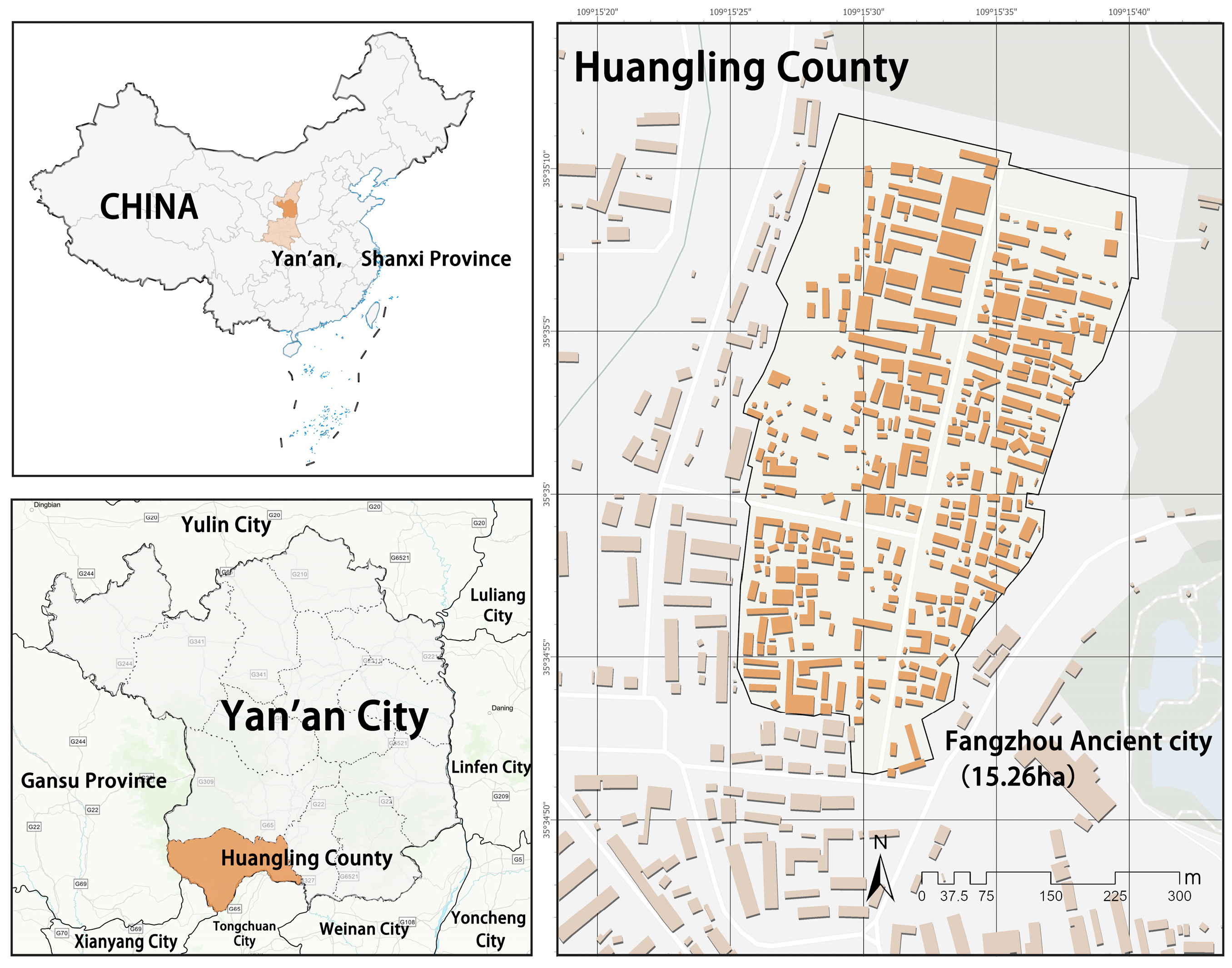
2.1. Study Area
2.2. Research Methodology
2.2.1. Data Acquisition and Pre-Processing
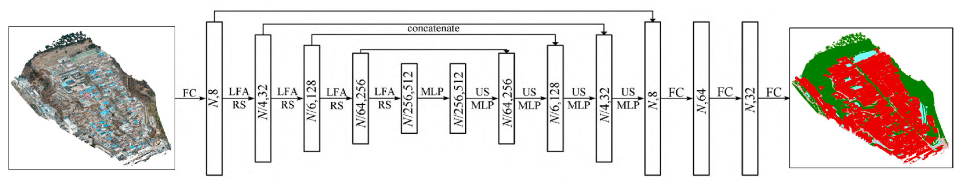
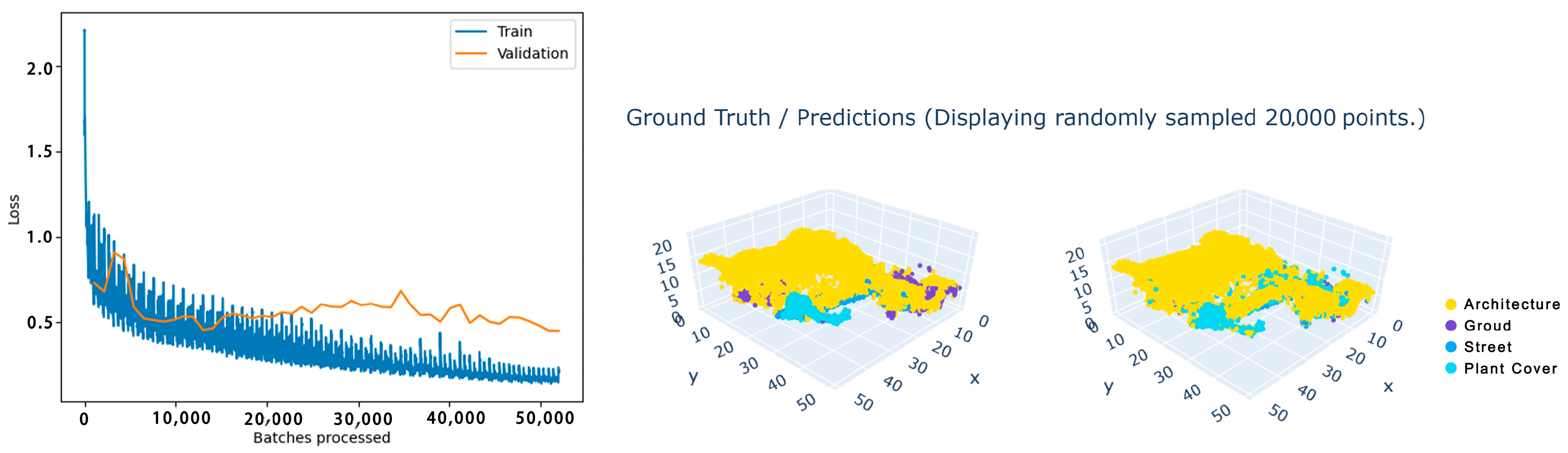
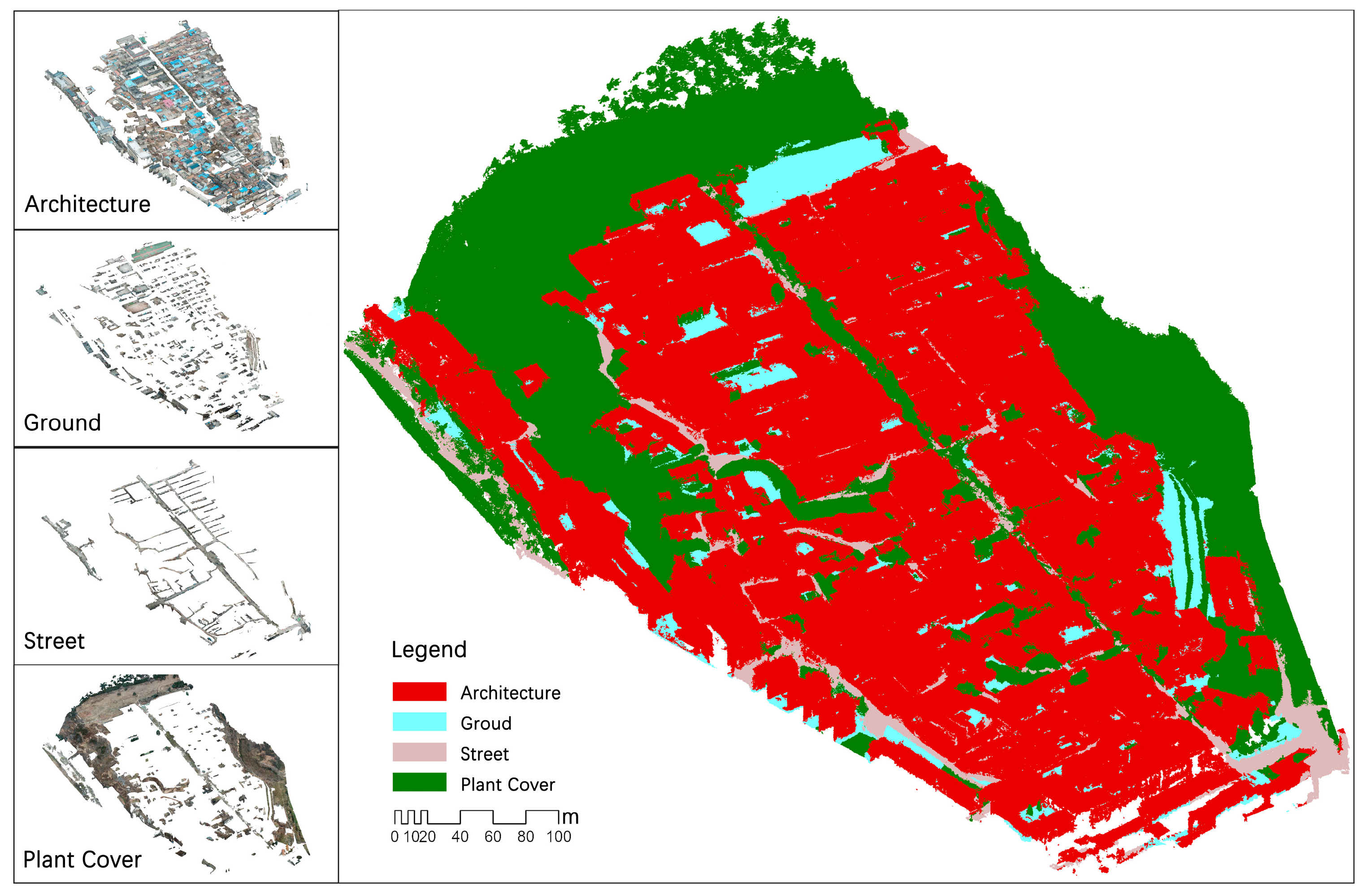
2.2.2. Point Cloud Classification Using the RandLA-Net Model
2.2.3. Data Analysis and Application
3. Results
3.1. Settlement Level
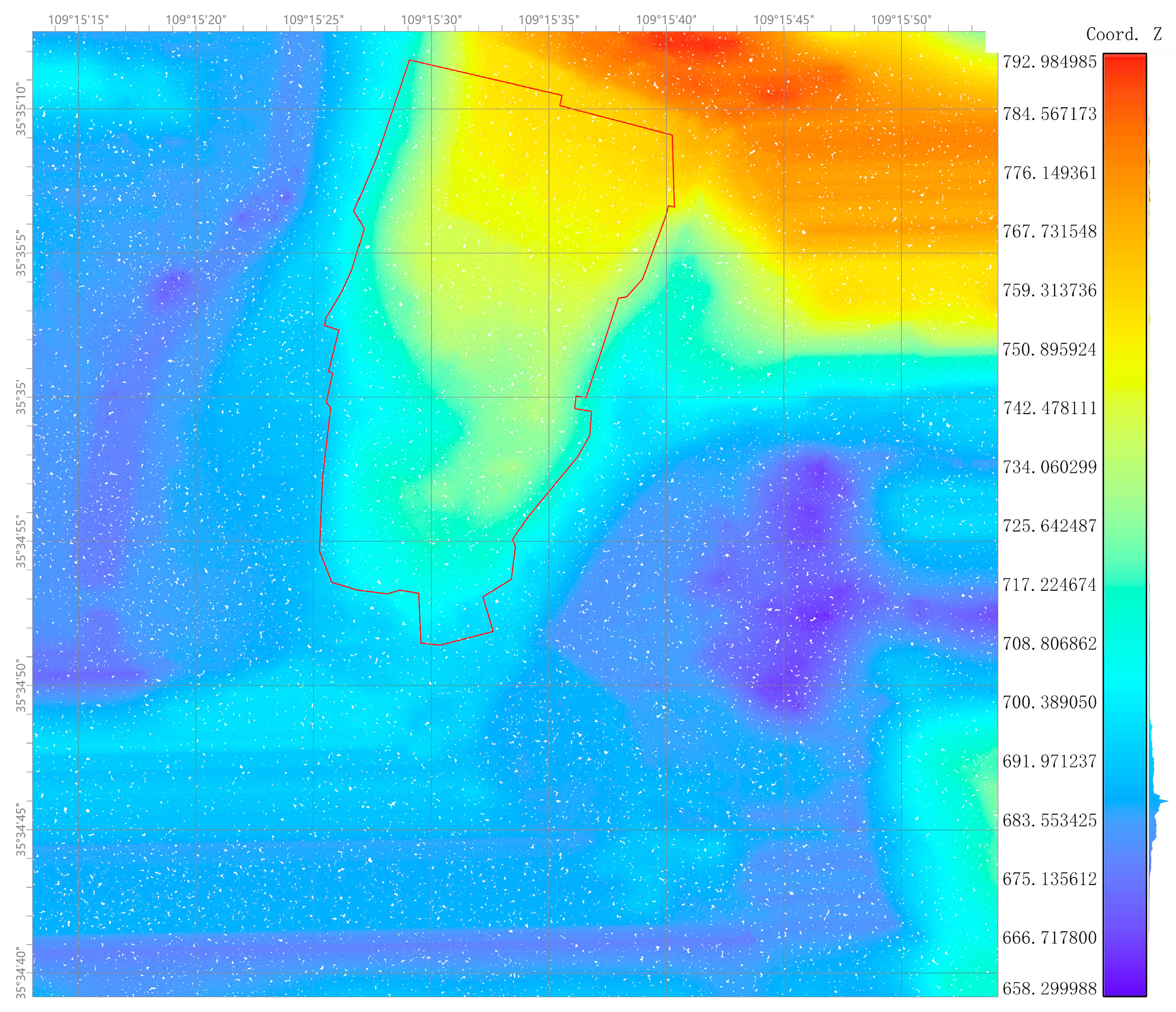
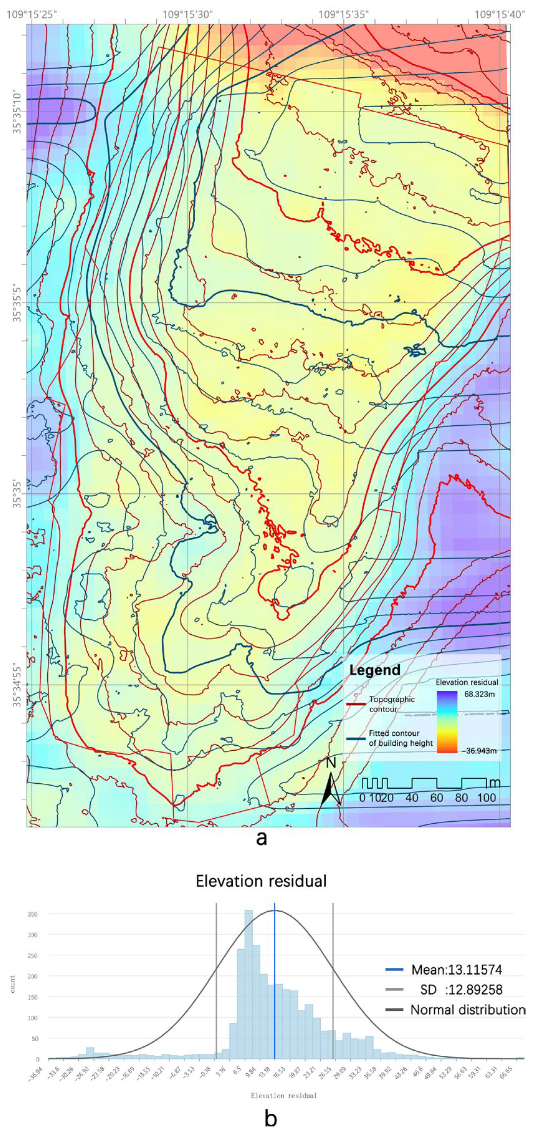
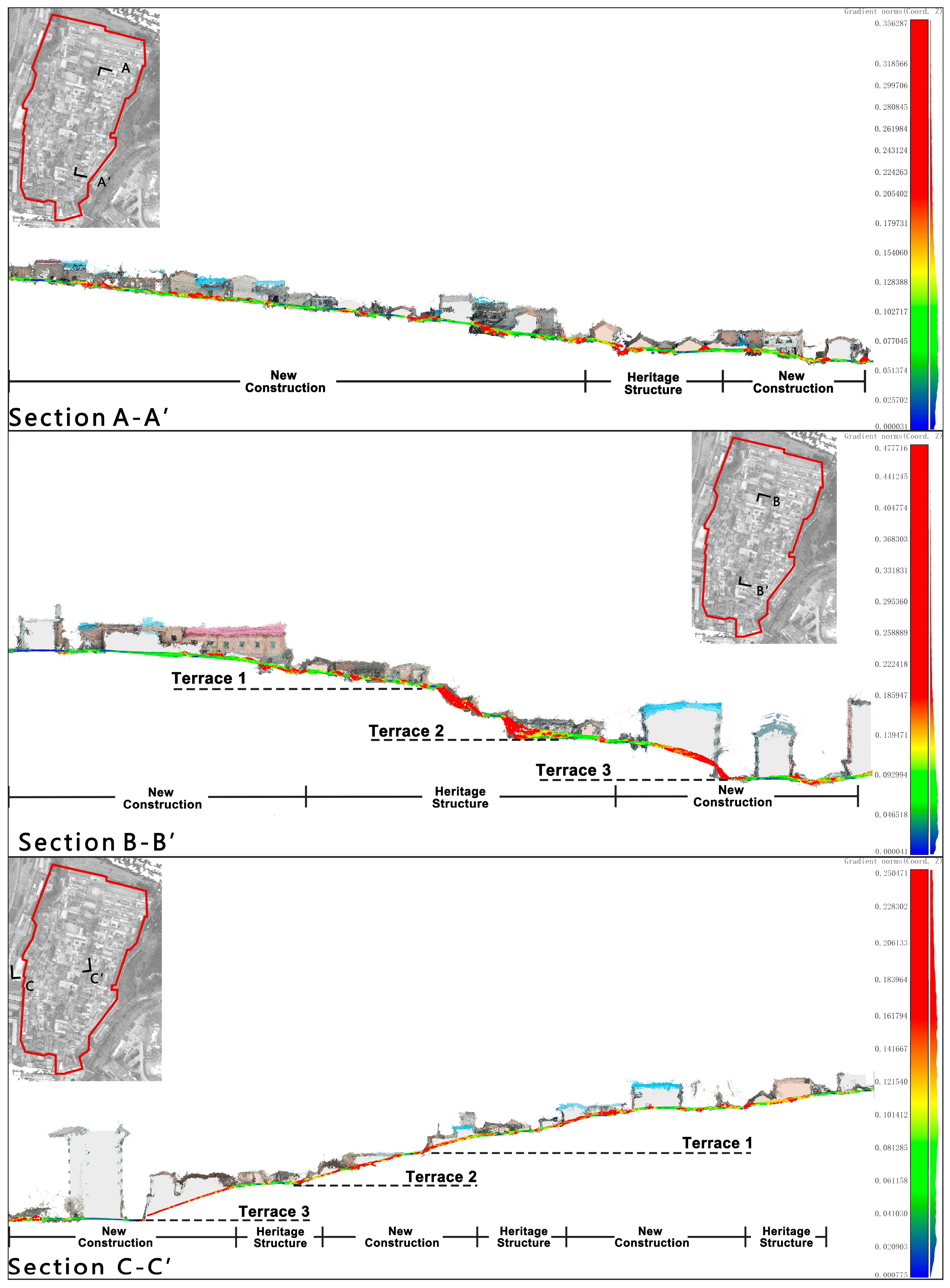
3.1.1. Characterization of Hill Settlements
3.1.2. Characterization of Distribution Environment
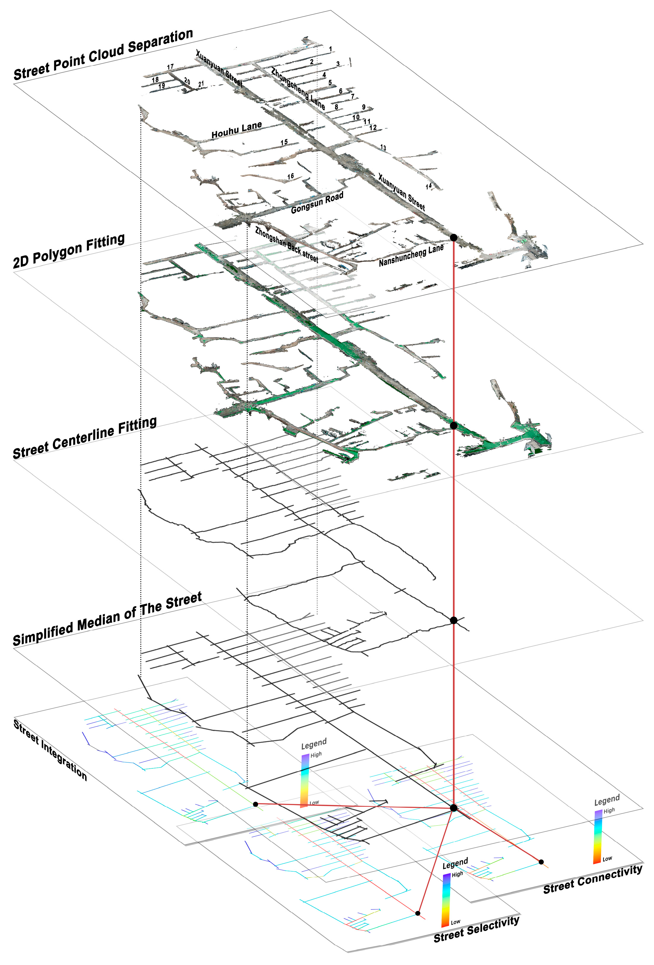
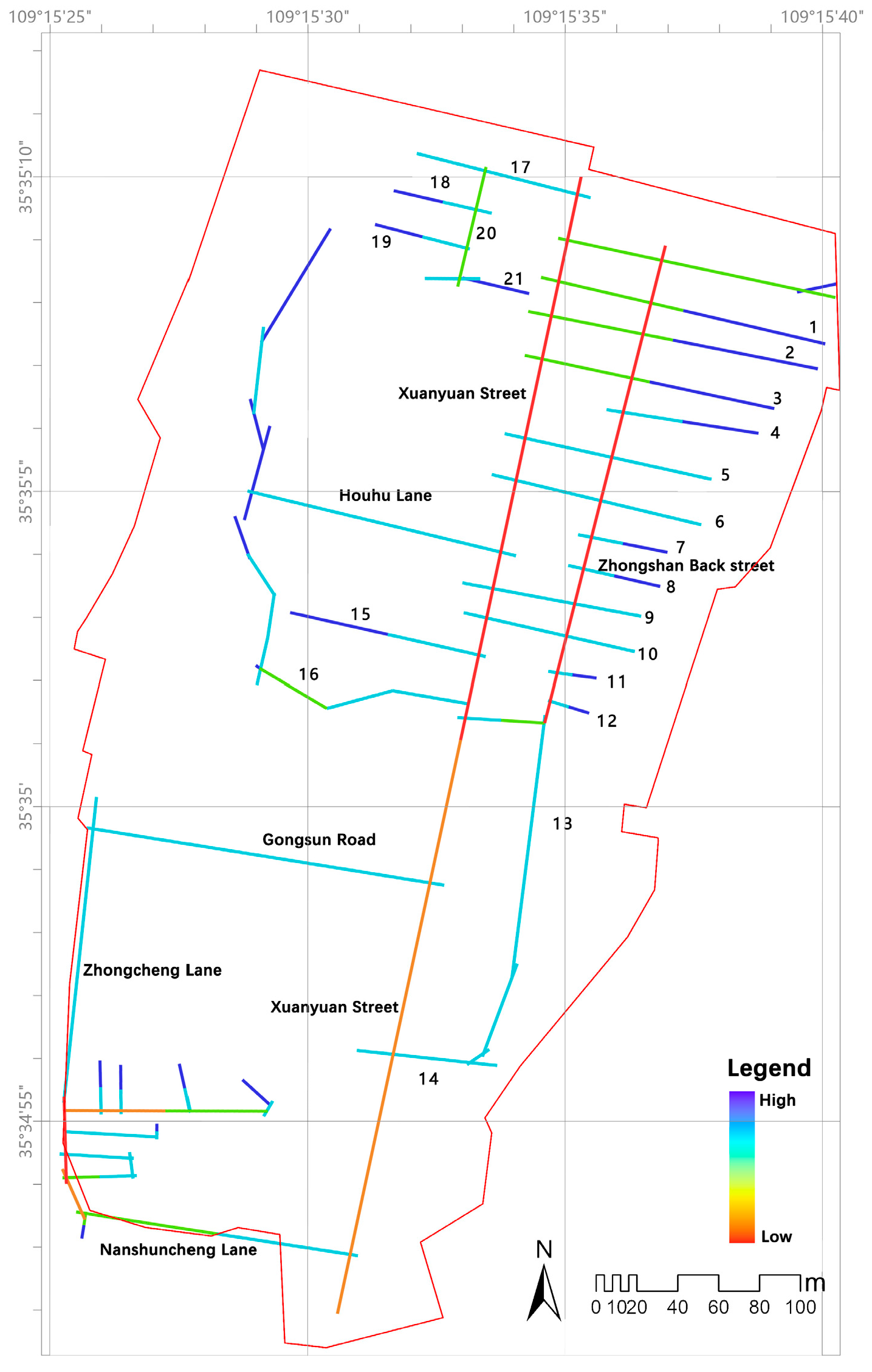
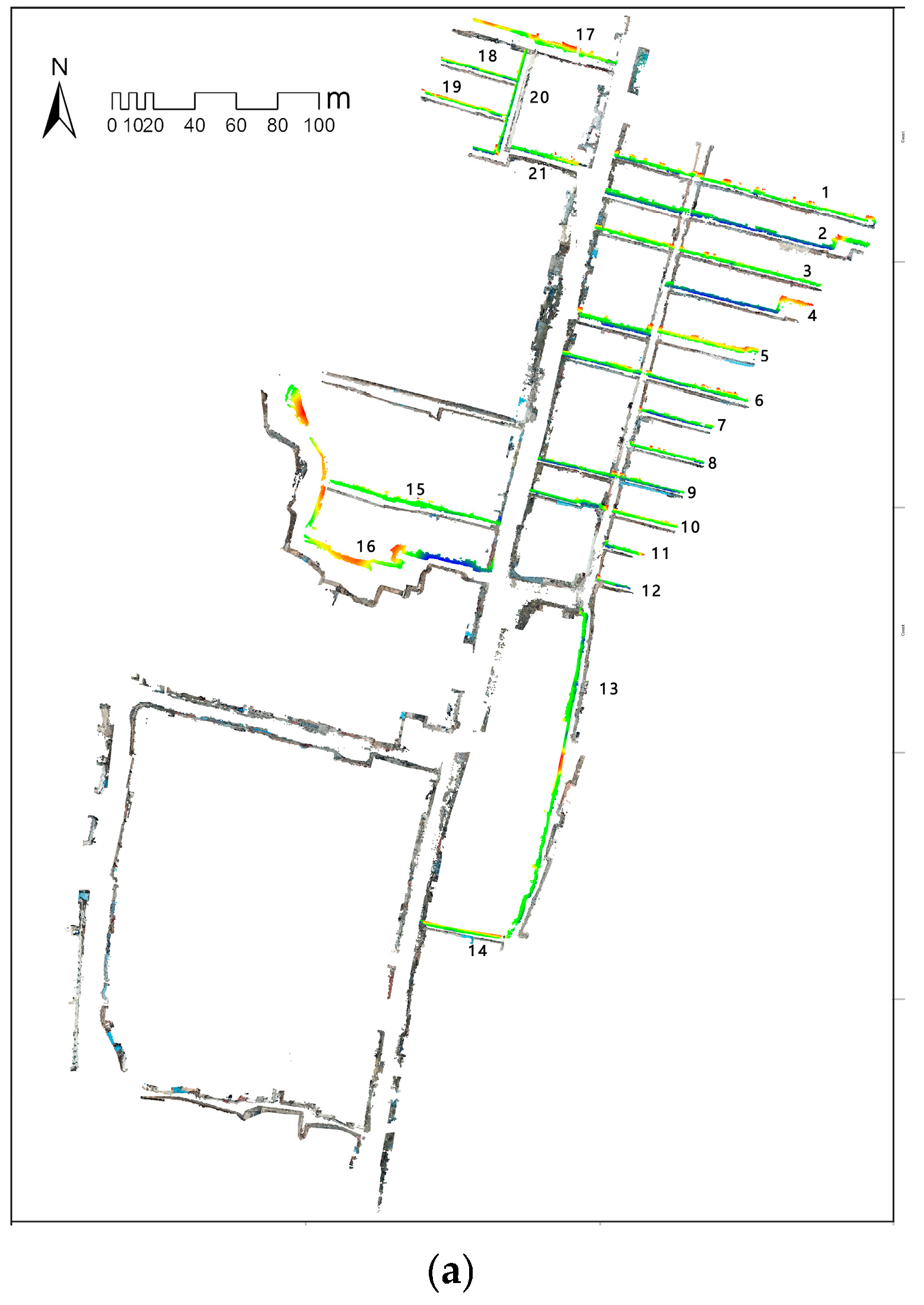
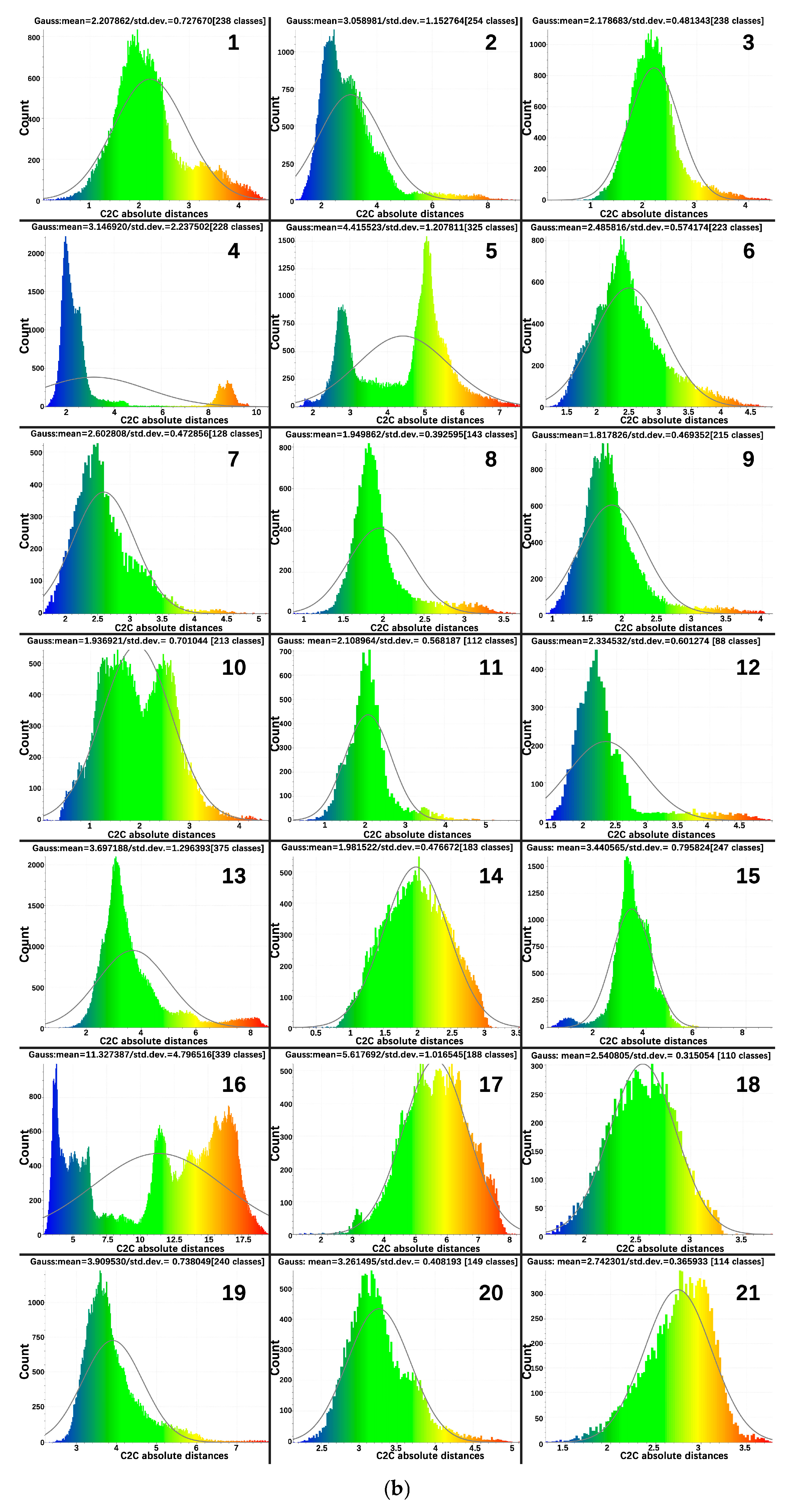
3.2. Street Level
3.2.1. Street Spatial Connections
- Integration
- 2.
- Choice
- 3.
- Connectivity
3.2.2. Proportion of Street Space
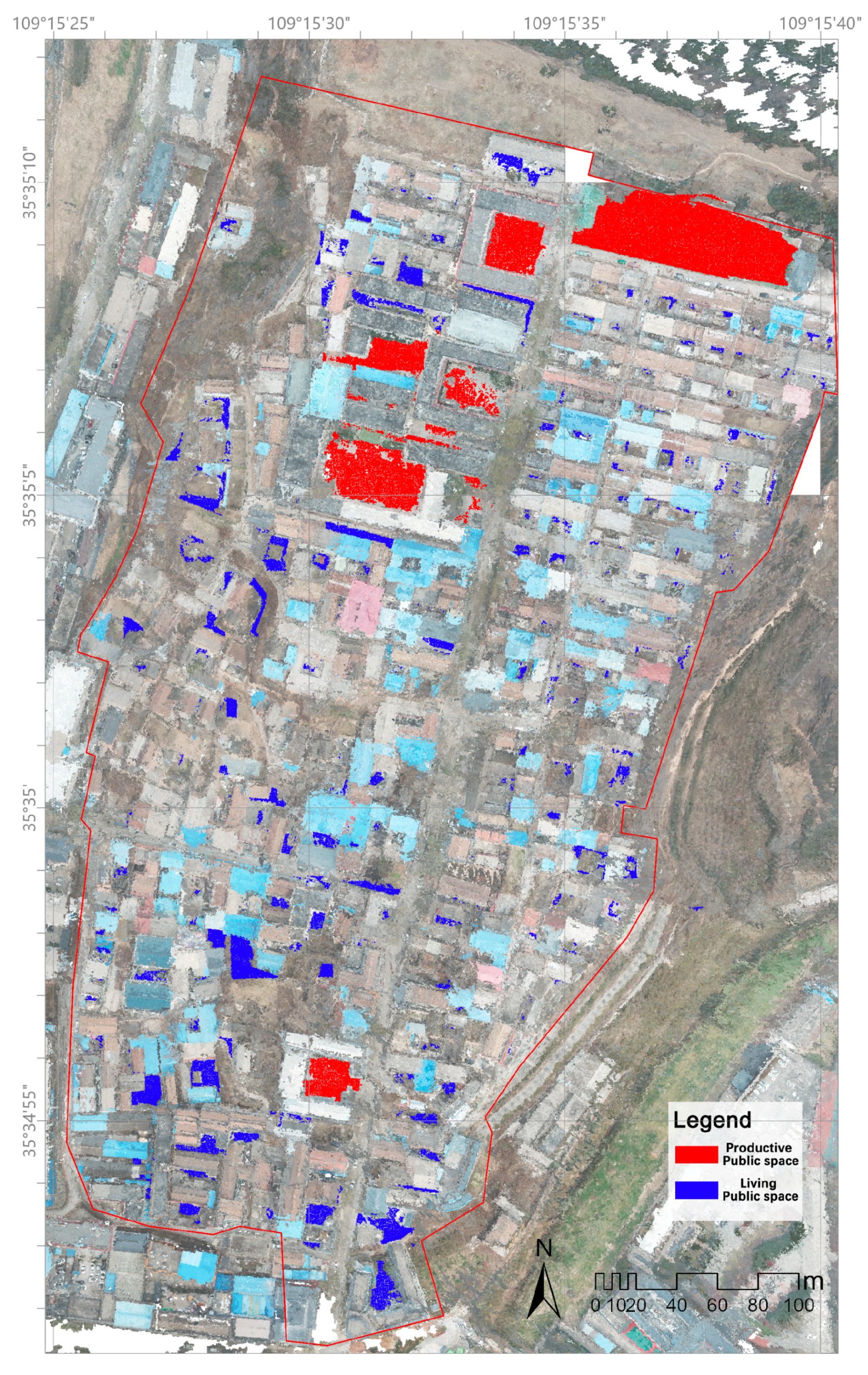
3.2.3. Distribution of Public Space
3.3. Building Level
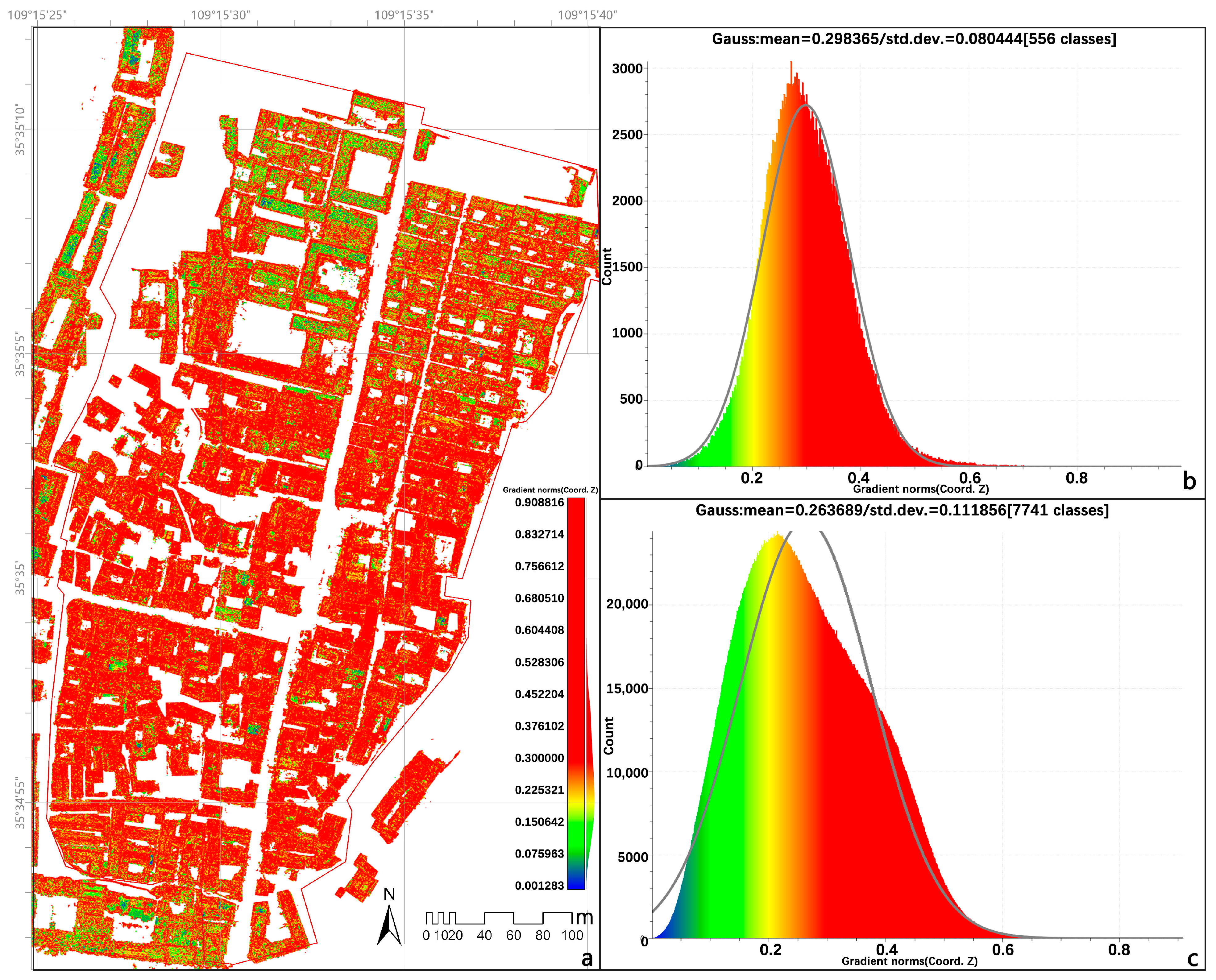
3.3.1. Characterization of Building Morphology
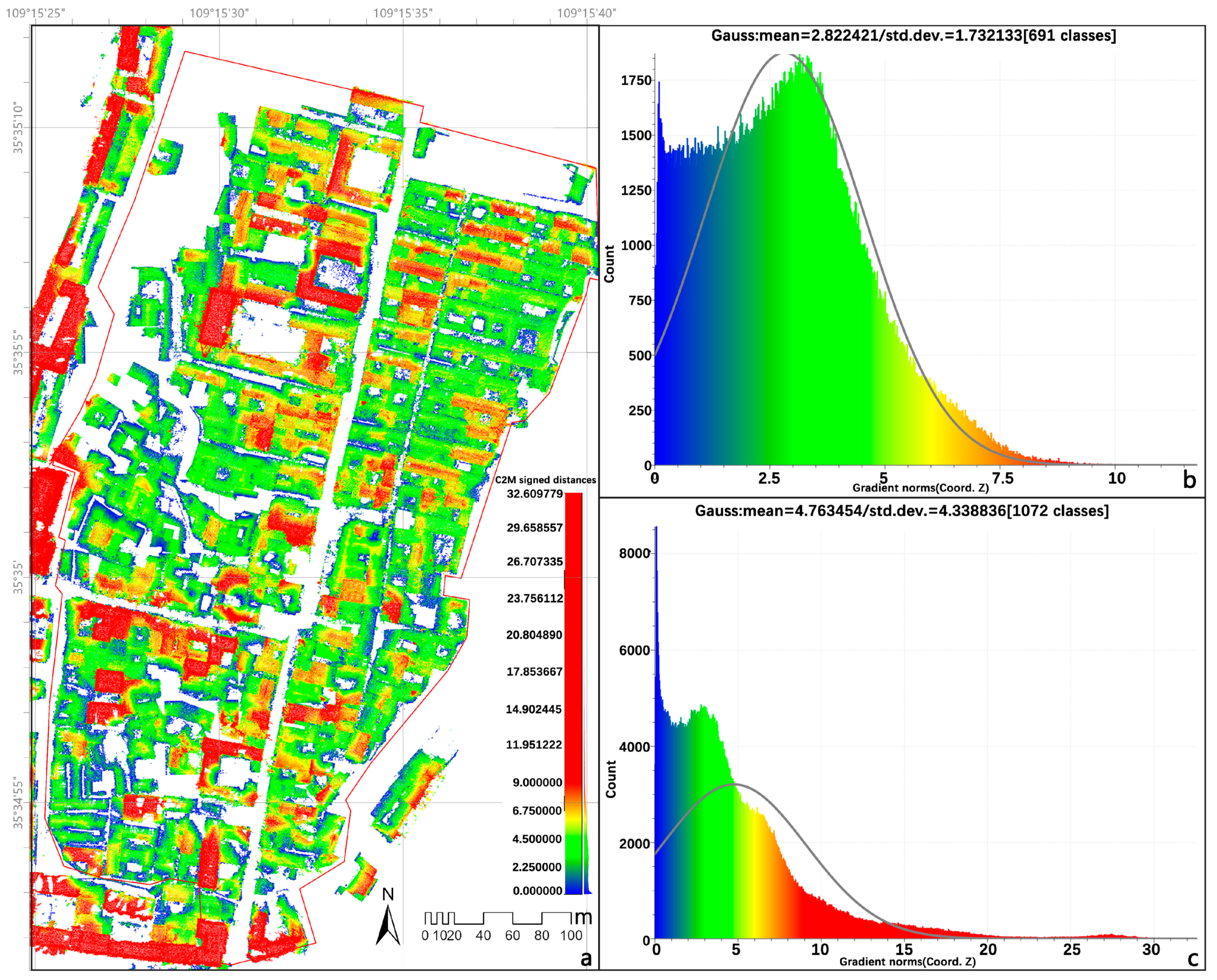
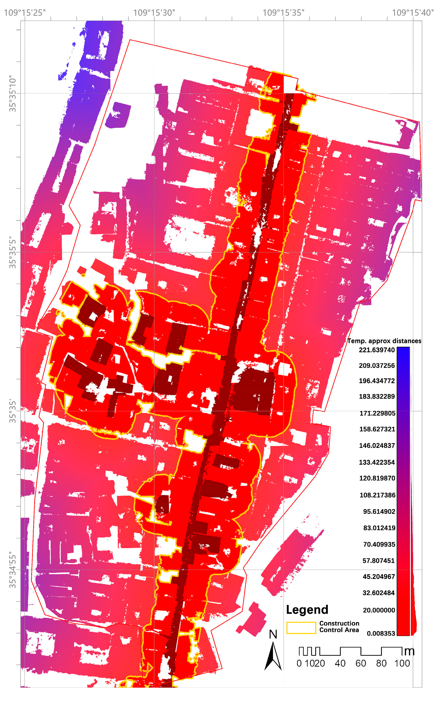
3.3.2. Traditional Building Zoning Control Analysis
4. Discussion
5. Conclusions
5.1. Key Research Findings
- Topographic adaptability: Historical architectural clusters were constructed on gentle slopes of Loess Plateau terraces, forming an organic coupling with undulating landforms, whereas modern buildings exhibit anomalous elevation increases on steep slopes, causing visual corridor ruptures between the plateau–city interface.
- Street hierarchy: The main arterial road (e.g., Xuanyuan Street) demonstrates the greatest width and spatial integration values, highlighting its core function as a cultural axis, while newly constructed alleys are predominantly narrow, eroding the continuity of historic spatial patterns.
- Morphological evolution: Modern buildings widely exceed traditional height limits, with diversified roof slopes exacerbating visual fragmentation and intensifying clashes between historic and contemporary architectural clusters.
- Methodological innovation: By leveraging the RandLA-Net model and multi-spectral features, high-accuracy point cloud semantic segmentation (overall accuracy 86.93%) was achieved in complex historic urban environments, establishing a technical pathway for 3D extraction and 2D analysis of heritage spatial features. These findings comprehensively illustrate the spatial evolution of Fangzhou Ancient City under its mausoleum–city–mountain–water coupling pattern and provide quantitative foundations for planning decisions.
5.2. Theoretical and Practical Implications
5.3. Methodological Limitations
5.4. Future Research Directions
Author Contributions
Funding
Data Availability Statement
Conflicts of Interest
References
- Farahani, L.M.; Setayesh, M.; Shokrollahi, L. Contextualizing Palimpsest of Collective Memory in an Urban Heritage Site: Case Study of Chahar Bagh, Shiraz—Iran. Archnet-IJAR 2015, 9, 218–231. [Google Scholar] [CrossRef]
- Khalaf, R.W. A Proposal to Apply the Historic Urban Landscape Approach to Reconstruction in the World Heritage Context. Hist. Env. Policy Pract. 2018, 9, 39–52. [Google Scholar] [CrossRef]
- Jiang, J.; Zhou, T.; Han, Y.; Ikebe, K. Urban Heritage Conservation and Modern Urban Development from the Perspective of the Historic Urban Landscape Approach: A Case Study of Suzhou. Land 2022, 11, 1251. [Google Scholar] [CrossRef]
- Wang, S.; Gu, K. Pingyao: The Historic Urban Landscape and Planning for Heritage-Led Urban Changes. Cities 2020, 97, 102489. [Google Scholar] [CrossRef]
- UNESCO. Vienna Memorandum on ‘World Heritage and Contemporary Architecture-Managing the Historic Urban Landscape’; UNESCO: Paris, France, 2005. [Google Scholar]
- UNESCO World Heritage Centre. UNESCO’s World Heritage City Lab; UNESCO: Paris, France, 2025. [Google Scholar]
- He, Q.; Larkham, P.; Wu, J. Evaluating Historic Preservation Zoning Using a Landscape Approach. Land Use Policy 2021, 109, 105737. [Google Scholar] [CrossRef]
- Liu, T.; Butler, R.J.; Zhang, C. Evaluation of Public Perceptions of Authenticity of Urban Heritage under the Conservation Paradigm of Historic Urban Landscape—A Case Study of the Five Avenues Historic District in Tianjin, China. J. Archit. Conserv. 2019, 25, 228–251. [Google Scholar] [CrossRef]
- Oumelkheir, B.; Nadia, D. Assessment Process in the Delimitation of Historic Urban Landscape of Algiers by AHP. Misc. Geogr. 2021, 25, 110–126. [Google Scholar] [CrossRef]
- Zhao, X.; Marnane, K.; Greenop, K. The Role of Digital Technologies in Recording Values of Human Settlements: Testing a Practical Historic Urban Landscape Approach in China and India. Digit. Creat. 2021, 32, 253–274. [Google Scholar] [CrossRef]
- Li, X.; Hou, W.; Liu, M.; Yu, Z. Traditional Thoughts and Modern Development of the Historical Urban Landscape in China: Lessons Learned from the Example of Pingyao Historical City. Land 2022, 11, 247. [Google Scholar] [CrossRef]
- Sun, J.; Shao, L. Interpretation of Historic Urban Landscape Genes: A Case Study of Harbin, China. Land 2024, 13, 1988. [Google Scholar] [CrossRef]
- Wang, Y.; Jin, C.; Xu, D.; Wang, T.; Wang, B. Analysis of Multi-Dimensional Layers in Historic Districts Based on Theory of the Historic Urban Landscape: Taking Shenyang Fangcheng as an Example. Land 2024, 13, 1736. [Google Scholar] [CrossRef]
- Liu, Y.Q.; Chen, G.L.; Cai, Y.Z.; Li, M.H.; Chen, D.A.; Hu, X.Z. A Building Boundary Extraction Method Based on Adaptive Segmentation of Oblique Photogrammetric Point Cloud Density. Bull. Surv. Mapp. 2022, 9, 52–57. [Google Scholar] [CrossRef]
- Li, R. Evaluation of Rural Landscape Characteristics Based on UAV Oblique Photography: A Case Study of Zhanqi Village, Chengdu. Master’s Thesis, Sichuan Agricultural University, Chengdu, China, 2022. [Google Scholar] [CrossRef]
- Teng, Z.; Li, C.; Zhao, W.; Wang, Z.; Li, R.; Zhang, L.; Song, Y. Extraction and Analysis of Spatial Feature Data of Traditional Villages Based on the Unmanned Aerial Vehicle (UAV) Image. Mob. Inf. Syst. 2022, 2022, 1–16. [Google Scholar] [CrossRef]
- Zhu, C.; Li, R.; Luo, J.; Li, X.; Du, J.; Ma, J.; Hou, C.; Zeng, W. Research on Evaluating the Characteristics of the Rural Landscape of Zhanqi Village, Chengdu, China, Based on Oblique Aerial Photography by Unmanned Aerial Vehicles. Sustainability 2024, 16, 5151. [Google Scholar] [CrossRef]
- Wang, L.L.; Liu, Y.R.; Huang, W.C.; Han, J. Research on the Analysis Method of Traditional Village Landscape Features Based on Digital Technology: A Case Study of Xiaocuo Village, Quanzhou. Chin. Landsc. Archit. 2023, 39, 13–19. [Google Scholar] [CrossRef]
- Liu, Z.W.; Wang, T.F.; Jin, H.; He, D.; Lei, Y.K. Mountain Landscape Planning Based on UAV Oblique Photography: A Case Study of Xiangshan Village, Xinmi City. For. Surv. Plan. 2020, 45, 1–8. [Google Scholar]
- Liu, C.; Cao, Y.; Yang, C.; Zhou, Y.; Ai, M. Pattern Identification and Analysis for the Traditional Village Using Low Altitude UAV-Borne Remote Sensing: Multifeatured Geospatial Data to Support Rural Landscape Investigation, Documentation and Management. J. Cult. Herit. 2020, 44, 185–195. [Google Scholar] [CrossRef]
- Cen, Y.; Jia, W.; Dai, W.; Wang, C.; Wu, H. Analysis of Color Landscape Characteristics in “Beautiful Village” of China Based on 3D Real Scene Models. Rev. Int. Geomatique 2024, 33, 93–109. [Google Scholar] [CrossRef]
- Li, Z.; Wang, T.; Sun, S. Research on Quantitative Analysis Methods for the Spatial Characteristics of Traditional Villages Based on Three-Dimensional Point Cloud Data: A Case Study of Liukeng Village, Jiangxi, China. Land 2024, 13, 1261. [Google Scholar] [CrossRef]
- Kaushal, S.S.; Soto, M.G.; Napolitano, R. Three-Dimensional Digital Documentation of Tornado-Damaged Heritage Buildings. J. Struct. Eng. 2024, 150, 04724002. [Google Scholar] [CrossRef]
- Nwaogu, J.M.; Yang, Y.; Chan, A.P.C.; Chi, H. Application of Drones in the Architecture, Engineering, and Construction (AEC) Industry. Autom. Constr. 2023, 150, 104827. [Google Scholar] [CrossRef]
- Du, S.Y.; Liang, H. Application of UAV Oblique Photography in 3D Real Scene Modeling for Construction Projects. J. Civ. Eng. Inf. Technol. 2018, 10, 72–77. [Google Scholar] [CrossRef]
- RandLA-Net: Efficient Semantic Segmentation of Large-Scale Point Clouds-All Databases. Available online: https://webofscience.clarivate.cn/wos/alldb/full-record/PPRN:14889910 (accessed on 14 April 2025).
- Li, Z.; Sun, S.; Zhou, C.C.; Tong, X.X.; Zhang, Y.X.; Li, Y. The “Correct Approach” to China’s Traditional Village Digital Museum: Mining and Quantifying Traditional Village Wisdom Through 3D Computational Analysis. Archit. J. 2019, 2, 74–80. [Google Scholar]
- Wang, C.; Ning, X.; Sun, L.; Zhang, L.; Li, W.; Bai, X. Learning Discriminative Features by Covering Local Geometric Space for Point Cloud Analysis. IEEE Trans. Geosci. Remote Sens. 2022, 60, 1–15. [Google Scholar] [CrossRef]
- Guo, Z.; Feng, C.-C. Using Multi-Scale and Hierarchical Deep Convolutional Features for 3D Semantic Classification of TLS Point Clouds. Int. J. Geogr. Inf. Sci. 2020, 34, 661–680. [Google Scholar] [CrossRef]
- Qi, C.R.; Yi, L.; Su, H.; Guibas, L.J. PointNet++: Deep Hierarchical Feature Learning on Point Sets in a Metric Space. arXiv 2017, arXiv:1706.02413. [Google Scholar] [CrossRef]
- Chen, J.; Zhao, Y.; Meng, C.; Liu, Y. Multi-Feature Aggregation for Semantic Segmentation of an Urban Scene Point Cloud. Remote Sens. 2022, 14, 5134. [Google Scholar] [CrossRef]
- Wang, H. Research on the Renewal Strategy of Fangzhou Ancient City in Huangling County from the Perspective of Spatial Genes. In Proceedings of the 2024 Annual Conference of China Urban Planning, Hefei, China, 26–28 April 2024; pp. 3180–3191. [Google Scholar] [CrossRef]
- Yin, X.M.; Zhang, K.L. Research on the Protection and Development of Imperial Mausoleum Cultural Heritage in Urban Renewal. Small Town Constr. 2020, 38, 53–60. [Google Scholar]
- Li, C.Y.; Li, Y.; Wang, R.R. Conservation and Renewal Strategies for Fangzhou Ancient City in Huangling from the Perspective of Urban Cultural Context. In Proceedings of the 2024 Annual Conference of China Urban Planning, Hefei, China, 26–28 April 2024; pp. 3473–3488. [Google Scholar] [CrossRef]
- Yin, X.M. Study on the Evolution of Spatial Patterns of Fangzhou Ancient City under the Influence of Mausoleum-City Relationships during the Ming and Qing Dynasties. Master’s Thesis, Beijing Forestry University, Beijing, China, 2021. [Google Scholar] [CrossRef]
- Huang, J.Y.; Wang, J.T. Living by the Mausoleum: Preliminary Study on the Construction of Human Settlements in Huangling Historical City. In Proceedings of the 2018 Annual Conference of China Urban Planning, Hangzhou, China, 24–26 November 2018; pp. 94–104. Available online: https://kns.cnki.net/KCMS/detail/detail.aspx?dbcode=CPFD&dbname=CPFDLAST2018&filename=ZHCG201811004010 (accessed on 5 February 2025).
- Colomina, I.; Molina, P. Unmanned Aerial Systems for Photogrammetry and Remote Sensing: A Review. ISPRS J. Photogramm. Remote Sens. 2014, 92, 79–97. [Google Scholar] [CrossRef]
- GB/T 27920.1-2011; Technical Specifications for UAV Aerial Photogrammetry—Part 1; General Requirements. Standards Press of China: Beijing, China, 2011.
- GB/T 13923-2022; Classification and Codes for Fundamental Geographic Information Features. Standards Press of China: Beijing, China, 2022.
- Huangling County People’s Government. Comprehensive Territorial Spatial Plan of Huangling County (2021–2035); Huangling County Natural Resources Bureau: Yan’an, China, 2021. [Google Scholar]
- GB 5035-2018; Standardization Administration of China. Standard for the Protection Planning of Historic and Cultural Cities. China Architecture & Building Press: Beijing, China, 2019.
- GB 50298-1999; Standardization Administration of China. Standard for the Planning of Scenic and Historic Areas. China Standards Press: Beijing, China, 2000.
- United Nations Educational, Scientific and Cultural Organization (UNESCO). Recommendation on the Historic Urban Landscape; UNESCO: Paris, France, 2011. [Google Scholar]
- Sukwai, J.; Mishima, N.; Srinurak, N. Identifying Visual Sensitive Areas: An Evaluation of View Corridors to Support Nature–Culture Heritage Conservation in Chiang Mai Historic City. BuiltHeritage 2022, 6, 23. [Google Scholar] [CrossRef]
- Wang, X.; Han, F.; Bian, X.; Li, Z. Mapping the Past with Present Digital Tools: Historic Urban Landscape Research in Chinese City, Xi’an Walled City Area. BuiltHeritage 2018, 2 (Suppl. S4), 42–57. [Google Scholar] [CrossRef]
- Shehata, A.M. Current Trends in Urban Heritage Conservation: Medieval Historic Arab City Centers. Sustainability 2022, 14, 607. [Google Scholar] [CrossRef]
- Körmeçli, Ş.P. Accessibility of Urban Tourism in Historical Areas: Analysis of UNESCO World Heritage Sites in Safranbolu. Sustainability 2024, 16, 2485. [Google Scholar] [CrossRef]
- Matrone, F.; Lingua, A.; Pierdicca, R.; Malinverni, E.S.; Paolanti, M.; Grilli, E.; Remondino, F.; Murtiyoso, A.; Landes, T. A Benchmark for Large-Scale Heritage Point Cloud Semantic Segmentation. Int. Arch. Photogramm. Remote Sens. Spatial Inf. Sci. 2020, 43, 1419–1426. [Google Scholar] [CrossRef]
- CNRS Images. How Forest Models Are Reconstructed in 3D from Photogrammetric Surveys. Available online: https://images.cnrs.fr/en/video/4059 (accessed on 24 May 2025).
- Autodesk. Digitizing Ipiranga Museum: Preserving Cultural Heritage Through GIS and BIM. Available online: https://www.autodesk.com/autodesk-university/de/article/Digitizing-Ipiranga-Museum-Preserving-Cultural-Heritage-through-GIS-and-BIM-2022 (accessed on 24 May 2025).
- Croce, V.; Caroti, G.; De Luca, L.; Jacquot, K.; Piemonte, A.; Véron, P. From the Semantic Point Cloud to Heritage-Building Information Modeling: A Semiautomatic Approach Exploiting Machine Learning. Remote Sens. 2021, 13, 461. [Google Scholar] [CrossRef]
- Ababneh, A. Digital Solutions for Cultural Heritage: Preservation, Interpretation, and Engagement in Line with the Venice Charter Principles. In Proceedings of the VIPERC2024: 3rd International Conference on Visual Pattern Extraction and Recognition for Cultural Heritage Understanding, Bari, Italy, 1 September 2024; Volume 3838. [Google Scholar]
- Chen, J.; Zhao, X.; Wang, H.; Yan, J.; Yang, D.; Xie, K. Portraying Heritage Corridor Dynamics and Cultivating Conservation Strategies Based on Environment Spatial Model: An Integration of Multi-Source Data and Image Semantic Segmentation. Herit. Sci. 2024, 12, 1–17. [Google Scholar] [CrossRef]
- Marmol, U.; Borowiec, N. Analysis and Verification of Building Changes Based on Point Clouds from Different Sources and Time Periods. Remote Sens. 2023, 15, 1414. [Google Scholar] [CrossRef]
- Yi, W.; Sutrisna, M. Drone Scheduling for Construction Site Surveillance. Comput. Aided Civ. Infrastruct. Eng. 2021, 36, 3–13. [Google Scholar] [CrossRef]
- Kleinschroth, F.; Banda, K.; Zimba, H.; Dondeyne, S.; Nyambe, I.; Spratley, S.; Winton, R.S. Drone Imagery to Create a Common Understanding of Landscapes. Landsc. Urban Plan. 2022, 228, 104571. [Google Scholar] [CrossRef]
- State Council of the People’s Republic of China. Regulations on the Protection of Historical and Cultural Cities, Towns and Villages; State Council: Beijing, China, 2019. (In Chinese) [Google Scholar]
- Tencent Research Institute. China Cultural Heritage Digitization Research Report 2023–2024; Tencent Research Institute: Shenzhen, China, 2024. (In Chinese) [Google Scholar]
- Lee, H.; Kim, B.-W.; Park, B.-W. Building 3D Reconstruction by the Integration of Drone and Terrestrial Laser Scanner Data. J. Korean Soc. Surv. Geod. Photogramm. Cartogr. 2024, 42, 245–252. [Google Scholar] [CrossRef]
- Stek, T.D. Drones over Mediterranean Landscapes: The Potential of Small UAV’s (Drones) for Site Detection and Heritage Management in Archaeological Survey Projects—A Case Study from Le Pianelle in the Tappino Valley, Molise (Italy). J. Cult. Herit. 2016, 22, 1066–1071. [Google Scholar] [CrossRef]
- Zhang, C.; Tian, Y.; Zhang, J. Complex Image Background Segmentation for Cable Force Estimation of Urban Bridges with Drone-Captured Video and Deep Learning. Struct. Control. Health Monit. 2022, 29, e2910. [Google Scholar] [CrossRef]
- Cho, H.L.J.; Lee, S.B.; Yoo, H.C. A Study on DEM-Based Automatic Calculation of Earthwork Volume for BIM Application. J. Korean Soc. Surv. Geod. Photogramm. Cartogr. 2020, 38, 131–140. [Google Scholar] [CrossRef]
- Uribe, P.; Angás, J.; Romeo, F.; Pérez-Cabello, F.; Santamaría, D. Mapping Ancient Battlefields in a Multi-Scalar Approach Combining Drone Imagery and Geophysical Surveys: The Roman Siege of the Oppidum of Cabezo de Alcal? (Azaila, Spain). J. Cult. Herit. 2021, 48, 11–23. [Google Scholar] [CrossRef]


| Class Name | Precision | Recall | F1_Score |
|---|---|---|---|
| 2 | Ground | 0.846398 | 0.659517 |
| 3 | Plant cover | 0.645526 | 0.887858 |
| 6 | Architecture | 0.942402 | 0.929425 |
| 11 | Street | 0.792904 | 0.63281 |
| Grade | Spatial Characteristics | Quantitative Indicators | Analyzing Software/Instructions |
|---|---|---|---|
| Colony level | Mountain settlement characterization | Terrain fit | In conjunction with GIS |
| DEM | Direct computation through the point cloud | ||
| Elevation residuals | In conjunction with GIS | ||
| Distributional environmental characteristics | Slope | Direct computation through the point cloud | |
| Building profiles | |||
| Street level | Street space proportions | Street width | Direct computation through the point cloud |
| Street space connections | Integration | In conjunction with GIS | |
| Selectivity | |||
| Connection value | |||
| Public space | Distribution of public space | Direct computation through the point cloud | |
| Architectural level | Building morphological features | Building roof slopes | Direct computation through the point cloud |
| Building roof height | |||
| Relationship between historic and modern architecture | Building spacing |
Disclaimer/Publisher’s Note: The statements, opinions and data contained in all publications are solely those of the individual author(s) and contributor(s) and not of MDPI and/or the editor(s). MDPI and/or the editor(s) disclaim responsibility for any injury to people or property resulting from any ideas, methods, instructions or products referred to in the content. |
© 2025 by the authors. Licensee MDPI, Basel, Switzerland. This article is an open access article distributed under the terms and conditions of the Creative Commons Attribution (CC BY) license (https://creativecommons.org/licenses/by/4.0/).
Share and Cite
Wang, J.; Gu, Y.; Su, X.; Ran, L.; Zhang, K. Spatial Analysis of Urban Historic Landscapes Based on Semiautomatic Point Cloud Classification with RandLA-Net Model—Taking the Ancient City of Fangzhou in Huangling County as an Example. Land 2025, 14, 1156. https://doi.org/10.3390/land14061156
Wang J, Gu Y, Su X, Ran L, Zhang K. Spatial Analysis of Urban Historic Landscapes Based on Semiautomatic Point Cloud Classification with RandLA-Net Model—Taking the Ancient City of Fangzhou in Huangling County as an Example. Land. 2025; 14(6):1156. https://doi.org/10.3390/land14061156
Chicago/Turabian StyleWang, Jiaxuan, Yixi Gu, Xinyi Su, Li Ran, and Kaili Zhang. 2025. "Spatial Analysis of Urban Historic Landscapes Based on Semiautomatic Point Cloud Classification with RandLA-Net Model—Taking the Ancient City of Fangzhou in Huangling County as an Example" Land 14, no. 6: 1156. https://doi.org/10.3390/land14061156
APA StyleWang, J., Gu, Y., Su, X., Ran, L., & Zhang, K. (2025). Spatial Analysis of Urban Historic Landscapes Based on Semiautomatic Point Cloud Classification with RandLA-Net Model—Taking the Ancient City of Fangzhou in Huangling County as an Example. Land, 14(6), 1156. https://doi.org/10.3390/land14061156