
Tree-Ring Chronological Investigation on the Oak Poles of the Prehistoric Settlement of “Gran Carro” in Lake Bolsena, Central Italy: Landscape and Human Occupation

 , ,
, ,  , ,
, ,
Abstract

1. Introduction
2. Materials and Methods
2.1. Site Description
2.2. Poles Sampling
2.3. Dendrochronological Analysis and Wiggle Matching
3. Results and Discussion
3.1. Dendrochronological Analysis and Tree-Ring Pattern
3.2. Absolute Dating and Wiggle Matching
4. Conclusions
Supplementary Materials
Author Contributions
Funding
Data Availability Statement
Acknowledgments
Conflicts of Interest
References
- Domínguez-Delmás, M. Seeing the forest for the trees: New approaches and challenges for dendroarchaeology in the 21st century. Dendrochronologia 2020, 62, 125731. [Google Scholar] [CrossRef]
- Billamboz, A. Dealing with heteroconnections and short tree-ring series at different levels of dating in the dendrochronology of the Southwest German pile-dwellings. Dendrochronologia 2008, 26, 145–155. [Google Scholar] [CrossRef]
- Bräker, O.U.; Bill, J.; Mühlethaler, B.; Schoch, W.; Schweingruber, F.H.; Haas, A. Zum derzeitigen stand der nassholzkonservierung. Diskussion der grundlagen und resultate eines von fachlaboratorien 1976–1978 durchgefuehrten methodenvergleiches. Z. Schweiz. Archaeol. Kunstgesch. 1979, 36, 97–145. [Google Scholar]
- Broda, M.; Hill, C.A.S. Conservation of Waterlogged Wood—Past, Present and Future Perspectives. Forests 2021, 12, 1193. [Google Scholar] [CrossRef]
- López-Bultó, O.; Piqué Huerta, R. Wood Procurement at the Early Neolithic site of La Draga (Banyoles, Barcelona). J. Wetl. Archaeol. 2018, 18, 56–76. [Google Scholar] [CrossRef]
- Huber, B. Aufbau Einer Mitteleuropäischen Jahrring-Chronologie; Sauerländer: Meschede, Germany, 1941. [Google Scholar]
- Rump, H.H. Bruno Huber (1899–1969)—Botaniker und Dendrochronologe; Ulmer: Stuttgart, Germany, 2011. [Google Scholar]
- Niebieszczański, J.; Kołaczek, P.; Karpińska-Kołaczek, M.; Hildebrandt-Radke, I.; Gałka, M.; Kneisel, J. Consequences of Lake Expansion and Disappearance for the Complex of Bronze and Iron Age Settlements at Bruszczewo (Western Poland, Central Europe). Environ. Archaeol. 2024, 29, 543–561. [Google Scholar] [CrossRef]
- Vitali, F.; Caldi, C.; Benucci, M.; Marzaioli, F.; Moioli, P.; Seccaroni, C.; De Ruggieri, B.; Romagnoli, M. The vernacular sculpture of Saint Anthony the Abbot of Museo Colle del Duomo in Viterbo (Italy). Diagnostic and Wood dating. J. Cult. Herit. 2021, 48, 299–304. [Google Scholar] [CrossRef]
- Andreaki, V.; Barceló, J.A.; Antolín, F.; Gassmann, P.; Hajdas, I.; López-Bultó, O.; Martínez-Grau, H.; Morera, N.; Palomo, A.; Piqué, R.; et al. Absolute chronology at the waterlogged site of La Draga (Lake Banyoles, NE Iberia): Bayesian chronological models integrating tree-ring measurement, radiocarbon dates and micro-stratigraphical data. Radiocarbon 2022, 64, 907–948. [Google Scholar] [CrossRef]
- Billamboz, A. Timber from Old and Young Trees: Dendrotypology as the Backbone of the Dendroarchaeological Investigations of Prehistoric Fish Traps and Pile Dwellings in South-West Germany. J. Wetl. Archaeol. 2014, 14, 48–57. [Google Scholar] [CrossRef]
- Čufar, K.; Tegel, W.; Merela, M.; Kromer, B.; Velušček, A. Eneolithic pile dwellings south of the Alps precisely dated with tree-ring chronologies from the north. Dendrochronologia 2015, 35, 91–98. [Google Scholar] [CrossRef]
- Domínguez-Delmás, M.; Schroeder, H.; Kuitems, M.; Haneca, K.; Archangel, S.; van Duin, P.; Piena, H. A stepwise multidisciplinary approach to determine the date and provenance of historical wooden objects. J. Cult. Herit. 2023, 62, 430–440. [Google Scholar] [CrossRef]
- Rybníček, M.; Chlup, T.; Kalábek, M.; Kalábková, P.; Kočár, P.; Kyncl, T.; Muigg, B.; Tegel, W.; Vostrovská, I.; Kolář, T. New dendroarchaeological evidence of water well constructions reveals advanced Early Neolithic craftsman skills. Dendrochronologia 2018, 50, 98–104. [Google Scholar] [CrossRef]
- Tegel, W.; Elburg, R.; Hakelberg, D.; Stäuble, H.; Büntgen, U. Early Neolithic Water Wells Reveal the World’s Oldest Wood Architecture. PLoS ONE 2012, 7, e51374. [Google Scholar] [CrossRef] [PubMed]
- López Castillo, E.M.; López-Bultó, O.; Berrocal Barberà, A.; Castanyer Masoliver, P.; Pera Isern, J.; Rodrigo Requena, E.; Piqué Huerta, R. Evidence of forestry management and arboriculture practices in waterlogged wood remains from three wells at the Roman and late antiquity sites of Iesso and Vilauba (Catalonia, Spain). Quat. Int. 2024, 699, 35–46. [Google Scholar] [CrossRef]
- Romagnoli, M.; D’Alessandro, L.; Seccaroni, C.; Moioli, P.; Poggi, D.; Grabner, M. The Pietà di Ragusa panel: A science-based contribution to its dating by dendrochronology, wood anatomy and pigment analysis. J. Cult. Herit. 2016, 21, 767–774. [Google Scholar] [CrossRef]
- Hodgins, G.; Kessler, N.; Guebard, M.; Hoedl, L. An Introduction to Wiggle-Match Dating and an Examination of Its Potential Impact on Chronological Studies in the South-west. In Pushing Boundaries in Southwestern Archaeology: Chronometry, Collections, and Contexts; University Press of Colorado: Louisville, CO, USA, 2022; pp. 116–133. [Google Scholar] [CrossRef]
- Haneca, K.; Katarina, Č.; Beeckman, H. Oaks, tree-rings and wooden cultural heritage: A review of the main characteristics and applications of oak dendrochronology in Europe. J. Archaeol. Sci. 2009, 36, 1–11. [Google Scholar] [CrossRef]
- Foletti, I.; Romagnoli, M.; Liccioli, L.; Fedi, M.; Saccuman, R. Wiggle matching analysis of the doors of Santa Sabina in Rome. RIHA J. 2019, 1–7. [Google Scholar] [CrossRef]
- Ehrlich, Y.; Regev, L.; Kerem, Z.; Boaretto, E. Radiocarbon Dating of an Olive Tree Cross-Section: New Insights on Growth Patterns and Implications for Age Estimation of Olive Trees. Front. Plant Sci. 2017, 8, 1918. [Google Scholar] [CrossRef]
- Reimer, P.J.; Austin, W.E.N.; Bard, E.; Bayliss, A.; Blackwell, P.G.; Bronk Ramsey, C.; Butzin, M.; Cheng, H.; Edwards, R.L.; Friedrich, M.; et al. The IntCal20 Northern Hemisphere Radiocarbon Age Calibration Curve (0–55 cal kBP). Radiocarbon 2020, 62, 725–757. [Google Scholar] [CrossRef]
- Quarta, G.; Pezzo, M.I.; Marconi, S.; Tecchiati, U.; D’Elia, M.; Calcagnile, L. Wiggle-Match Dating of Wooden Samples from Iron Age Sites in Northern Italy. Radiocarbon 2010, 52, 915–923. [Google Scholar] [CrossRef]
- Hadden, C.S.; Napora, K.G.; Tharp, B.W. Approximate” wiggle-match dating applied to early American museum objects. Radiocarbon 2024, 66, 1616–1629. [Google Scholar] [CrossRef]
- Martinelli, N. Prehistoric pile-dwellings in northern Italy: An archaeological and dendrochronological overview. In Proceedings of the ARCADE. Approche Diachronique et Regards Croisés: Archéologie, Dendrochronologie et Environnement, Aix-en-Provence, France, 10–11 April 2014; pp. 69–78. [Google Scholar]
- Capano, M.; Martinelli, N.; Baioni, M.; Tuna, T.; Bernabei, M.; Bard, E. Is the dating of short tree-ring series still a challenge? New evidence from the pile dwelling of Lucone di Polpenazze (northern Italy). J. Archaeol. Sci. 2020, 121, 105190. [Google Scholar] [CrossRef]
- Barbaro, B.; Severi, E. L’abitato sommerso della prima età del Ferro del Gran Carro di Bolsena: Verso una nuova prospettiva. Anal. Archaeol. 2018, 4, 25–51. [Google Scholar]
- Bartoloni, G. Introduzione All’etruscologia; Hoepli: Milano, Italy, 2012. [Google Scholar]
- Pacciarelli, M. Dal Villaggio Alla Città: La Svolta Protourbana del 1000 a.C. nell’Italia Tirrenica; Firenze University Press: Firenze, Italy, 2001. [Google Scholar]
- Bartoloni, G. La Cultura Villanoviana. All’inizio Della Storia Etrusca; Carocci Editore: Rome, Italy, 2002. [Google Scholar]
- Peroni, R. Protostoria dell’Italia Continentale. La Penisola Italiana Nelle età del Bronzo e del Ferro; Bibioteca di Storia Patria: Roma, Italy, 1989; Volume 9. [Google Scholar]
- Guidi, A. Preistoria Della Complessità Sociale; Laterza: Bari, Italy, 2010. [Google Scholar]
- Belluomini, G.; Manfra, L.; Proposito, A. Lago di Bolsena: Datazione con il Carbonio-14 di reperti sommersi e fluttuazioni oloceniche del livello delle acque. Alp. Mediterr. Quat. 1993, 6, 265–270. [Google Scholar]
- Barbaro, B. L’abitato protostorico del Gran Carro di Bolsena: Un complesso insediativo e cultuale di lunga durata sulle rive del lago: Rapporto preliminare sulle indagini 2020–2021. Archaeol. Maritima Mediterr. Int. J. Underw. Archaeol. 2021, 18, 13–34. [Google Scholar]
- Fundurulic, A.; Valenti, I.; Celant, A.; Barbaro, B.; Costa, M.; Manhita, A.; Severi, E.; Barrocas Dias, C.; Magri, D. Millets and cereal meals from the early iron age underwater settlement of “Gran Carro”(Bolsena Lake, Central Italy). Sustainability 2022, 14, 3941. [Google Scholar] [CrossRef]
- Porcaro, M.; Barbaro, B.; Canovaro, C.; Artioli, G.; Lucarelli, C.; Lugli, F.; Depalmas, A.; Brunetti, A. A multi analytical characterization of a small bronze figurine from Gran Carro site (Bolsena Lake, Italy). J. Archaeol. Sci. Rep. 2023, 51, 104230. [Google Scholar] [CrossRef]
- Caruso Fermé, L.; Mineo, M.; Ntinou, M.; Remolins, G.; Mazzucco, N.; Gibaja, J.F. Woodworking technology during the early Neolithic: First results at the site of La MARMOTTA (Italy). Quat. Int. 2021, 593–594, 399–406. [Google Scholar] [CrossRef]
- Tamburini, P. Un Abitato Villanoviano Perilacustre. Il “Gran Carro” sul Lago di Bolsena (1959–1985); Giogio Bretschneider Editore: Roma, Italy, 1995; Volume 113. [Google Scholar]
- Fioravanti, A.; Camerini, E. L’abitato Villanoviano del Gran Carro Sommerso nel Lago di Bolsena (1959–1977); Tipografia Fratelli De Gennaro—Legatoria Barbesin: Roma, Italia, 1977. [Google Scholar]
- Bolliger, M.; Maczkowski, A.; Francuz, J.; Reich, J.; Hostettler, M.; Ballmer, A.; Naumov, G.; Taneski, B.; Todoroska, V.; Szidat, S.; et al. Dendroarchaeology at Lake Ohrid: 5th and 2nd millennia BCE tree-ring chronologies from the waterlogged site of Ploča Mičov Grad, North Macedonia. Dendrochronologia 2023, 79, 126095. [Google Scholar] [CrossRef]
- Romagnoli, M.; Galotta, G.; Antonelli, F.; Sidoti, G.; Humar, M.; Kržišnik, D.; Čufar, K.; Davidde Petriaggi, B. Micro-morphological, physical and thermogravimetric analyses of waterlogged archaeological wood from the prehistoric village of Gran Carro (Lake Bolsena-Italy). J. Cult. Herit. 2018, 33, 30–38. [Google Scholar] [CrossRef]
- Sidoti, G.; Antonelli, F.; Galotta, G.; Moscatelli, C.; Kržišnik, D.; Vinciguerra, V.; Tamantini, S.; Marabottini, R.; Macro, N.; Romagnoli, M. Mineral compounds in oak waterlogged archaeological wood and volcanic lake compartments. EGUsphere 2023, 2023, 1–13. [Google Scholar] [CrossRef]
- Eckstein, D.; Bauch, J. Beitrag zur Rationalisierung eines dendrochronologischen Verfahrens und zur Analyse seiner Aussagesicherheit. Forstwiss. Cent. 1969, 88, 230–250. [Google Scholar] [CrossRef]
- Baillie, M.G.L.; Pilcher, J.R. A Simple Cross-Dating Program for Tree-Ring Research. Tree-Ring Bull. 1973, 33, 7–14. [Google Scholar]
- Hollstein, E. Jahrringkurnen aus dem prahistorischen salzbergwerk in hallstatt courbes dendrochronologiques a partir de bois des salines prehistoriques de Hallstatt. Archaol. Korresp. 1974, 4, 49–51. [Google Scholar]
- Bronk Ramsey, C.; van der Plicht, J.; Weninger, B. ‘Wiggle Matching’ Radiocarbon Dates. Radiocarbon 2001, 43, 381–389. [Google Scholar] [CrossRef]
- Bronk Ramsey, C. Radiocarbon Calibration and Analysis of Stratigraphy: The OxCal Program. Radiocarbon 1995, 37, 425–430. [Google Scholar] [CrossRef]
- Bronk Ramsey, C. Development of the Radiocarbon Calibration Program. Radiocarbon 2001, 43, 355–363. [Google Scholar] [CrossRef]
- Beffa, G.; Gobet, E.; Hächler, L.; Isola, I.; Morlock, M.A.; Sadori, L.; Schläfli, P.; Rey, F.; van Vugt, L.; Vogel, H.; et al. A novel, continuous high-resolution palaeoecological record from central Italy suggests comparable land-use dynamics in Southern and Central Europe during the Neolithic. Holocene 2024, 34, 1009–1024. [Google Scholar] [CrossRef]
- Beccaccioli, M.; Moricca, C.; Faino, L.; Reale, R.; Mineo, M.; Reverberi, M. The Neolithic site “La Marmotta”: DNA metabarcoding to identify the microbial deterioration of waterlogged archeological wood. Front. Microbiol. 2023, 14, 1–10. [Google Scholar] [CrossRef]
- Out, W.A.; Baittinger, C.; Čufar, K.; López-Bultó, O.; Hänninen, K.; Vermeeren, C. Identification of woodland management by analysis of roundwood age and diameter: Neolithic case studies. For. Ecol. Manag. 2020, 467, 118136. [Google Scholar] [CrossRef]
- Bleicher, N.; Staub, P. A question of method and place? A critical reappraisal of the methods of dendroarchaeology, anthracology, archaeobotany and roundwood analysis on the question when systematic woodland management began in Europe. Quat. Int. 2023, 659, 3–10. [Google Scholar] [CrossRef]
- Girardclos, O.; Dufraisse, A.; Dupouey, J.-L.; Coubray, S.; Ruelle, J.; Rathgeber, C.B.K. Improving identification of coppiced and seeded trees in past woodland management by comparing growth and wood anatomy of living sessile oaks (Quercus petraea). Quat. Int. 2018, 463, 219–231. [Google Scholar] [CrossRef]
- Müllerová, J.; Pejcha, V.; Altman, J.; Plener, T.; Dörner, P.; Doležal, J. Detecting Coppice Legacies from Tree Growth. PLoS ONE 2016, 11, e0147205. [Google Scholar] [CrossRef] [PubMed]
- Muigg, B.; Skiadaresis, G.; Tegel, W.; Herzig, F.; Krusic, P.J.; Schmidt, U.E.; Büntgen, U. Tree rings reveal signs of Europe’s sustainable forest management long before the first historical evidence. Sci. Rep. 2020, 10, 21832. [Google Scholar] [CrossRef] [PubMed]
- Bleicher, N. Dendrochronological analyses of wood samples from a Late Bronze to early Iron Age site at Lake Luokesa, Lithuania. Veg. Hist. Archaeobotany 2014, 23, 355–365. [Google Scholar] [CrossRef]
- Jansen, D.; Nelle, O. Neolithic wood usages: Examples from the lowlands of Germany. Saguntum Extra 2011, 11, 85–86. [Google Scholar]
- Menotti, F.; Baubonis, Z.; Brazaitis, D.; Higham, T.; Kvedaravicius, M.; Lewis, H.; Motuzaite, G.; Pranckenaite, E. The first lake-dwellers of Lithuania: Late Bronze Age pile settlements on Lake Luokesas. Oxf. J. Archaeol. 2005, 24, 381–403. [Google Scholar] [CrossRef]


| ID | Rings (yrs) | SW Rings 1 | SW Rings (%) | SW Width (cm) | SW Width (%) | HW Rings 2 | HW Rings (%) | HW Width (cm) | HW Width (%) | Mean Ring Width (1/100 mm) | Diameter (cm) |
|---|---|---|---|---|---|---|---|---|---|---|---|
| 002 | 39 | 14 | 36 | 2.3 | 29.6 | 39 | 64 | 5.5 | 70.4 | 248.1 ± 109.1 | 19.35 |
| 016 | 29 | 7 | 24 | 3.1 | 25.6 | 22 | 76 | 9.0 | 74.5 | 401.2 ± 116.2 | 24.07 |
| 036 | 52 | 17 | 33 | 2.2 | 22 | 35 | 67 | 7.8 | 78 | 123.7 ± 36.9 | 12.37 |
| 039 | 45 | 20 | 44 | 2.7 | 37.8 | 25 | 56 | 4.5 | 62.2 | 161.6 ± 65.3 | 14.54 |
| 050 | 34 | 21 | 62 | 4.5 | 57.8 | 13 | 38 | 3.3 | 42.2 | 230.2 ± 73.2 | 15.65 |
| 057 | 16 | 10 | 62.5 | 3.7 | 54.4 | 6 | 37.5 | 3.1 | 45.6 | 389.3 ± 110.7 | 12.46 |
| 125 | 38 | 18 | 47 | 2.1 | 26.3 | 20 | 53 | 5.9 | 73.8 | 193.1 ± 76.8 | 15.06 |
| 126 | 50 | 17 | 34 | 1.6 | 21.3 | 33 | 66 | 5.9 | 78.7 | 160.6 ± 65.9 | 16.06 |
| 133 | 33 | 9 | 27 | 2 | 33.3 | 24 | 73 | 4 | 66.7 | 325.4 ± 154.0 | 21.48 |
| 138 | 17 | 7 | 41 | 2.7 | 39.7 | 10 | 59 | 4.1 | 60.3 | 398.9 ± 108.0 | 13.56 |
| 144 | 49 | 20 | 41 | 2.1 | 30 | 29 | 59 | 4.9 | 70 | 162.2 ± 66.6 | 15.90 |
| 146 | 15 | 8 | 53 | 0 | 0 | 7 | 47 | 7.3 | 100 | 429.1 ± 109.9 | 12.87 |
| 152 | 44 | 24 | 54.5 | 3.1 | 43.1 | 20 | 45.5 | 4.1 | 56.9 | 133.1 ± 50.5 | 11.45 |
| 163 | 15 | - | - | 2.5 | 48.4 | 15 | 100 | 2.7 | 51.6 | 344.0 ± 106.5 | 10.32 |
| 170 | 23 | 18 | 78 | 1.7 | 17.7 | 5 | 22 | 7.9 | 17.7 | 411.5 ± 92.5 | 18.93 |
| 171 | 21 | 9 | 43 | 1.9 | 22.9 | 12 | 57 | 6.4 | 77.1 | 357.8 ± 79.9 | 15.03 |
| 173 | 32 | 15 | 47 | 4.2 | 38.9 | 17 | 53 | 6.6 | 61.1 | 276.7 ± 116.1 | 17.71 |
| 174 | 23 | 6 | 26 | 3.9 | 37.5 | 17 | 74 | 6.5 | 62.5 | 514.7 ± 161.3 | 23.68 |
| 177 | 54 | 16 | 30 | 3.0 | 33.2 | 38 | 70 | 6.1 | 32.7 | 168.4 ± 75.4 | 18.18 |
| 183 | 21 | 9 | 43 | 2.5 | 27.2 | 12 | 57 | 6.7 | 72.8 | 472.2 ± 226.8 | 19.83 |
| 189 | 36 | 15 | 42 | 2.4 | 27.7 | 21 | 58 | 6.4 | 72.3 | 244.4 ± 101.8 | 17.59 |
| 198 | 16 | 5 | 31 | 2.7 | 32.5 | 11 | 69 | 5.6 | 67.5 | 453.1 ± 164.9 | 14.50 |
| 304 | 39 | 11 | 28 | 3.2 | 28.8 | 28 | 72 | 7.9 | 71.2 | 202.2 ± 67.0 | 14.15 |
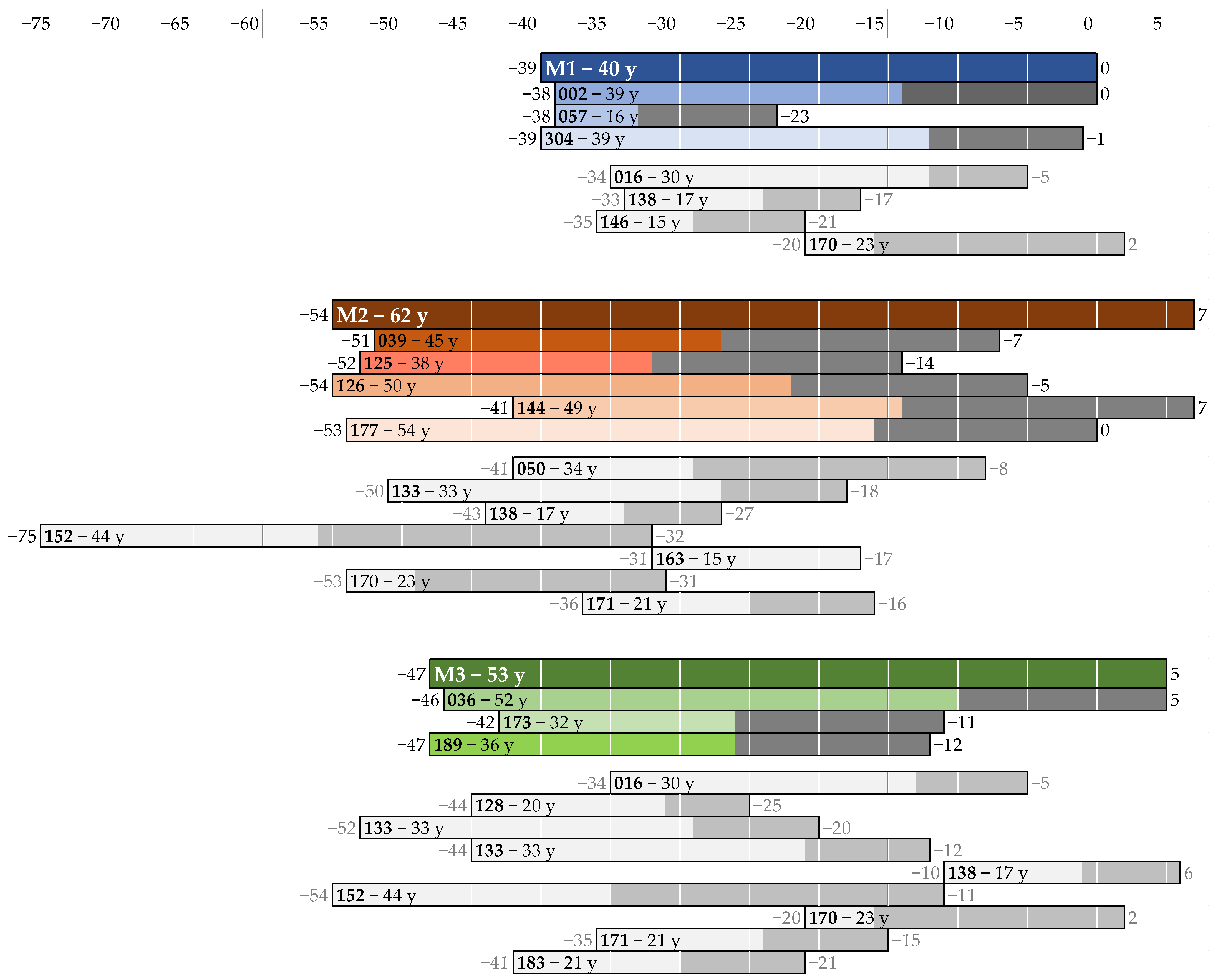
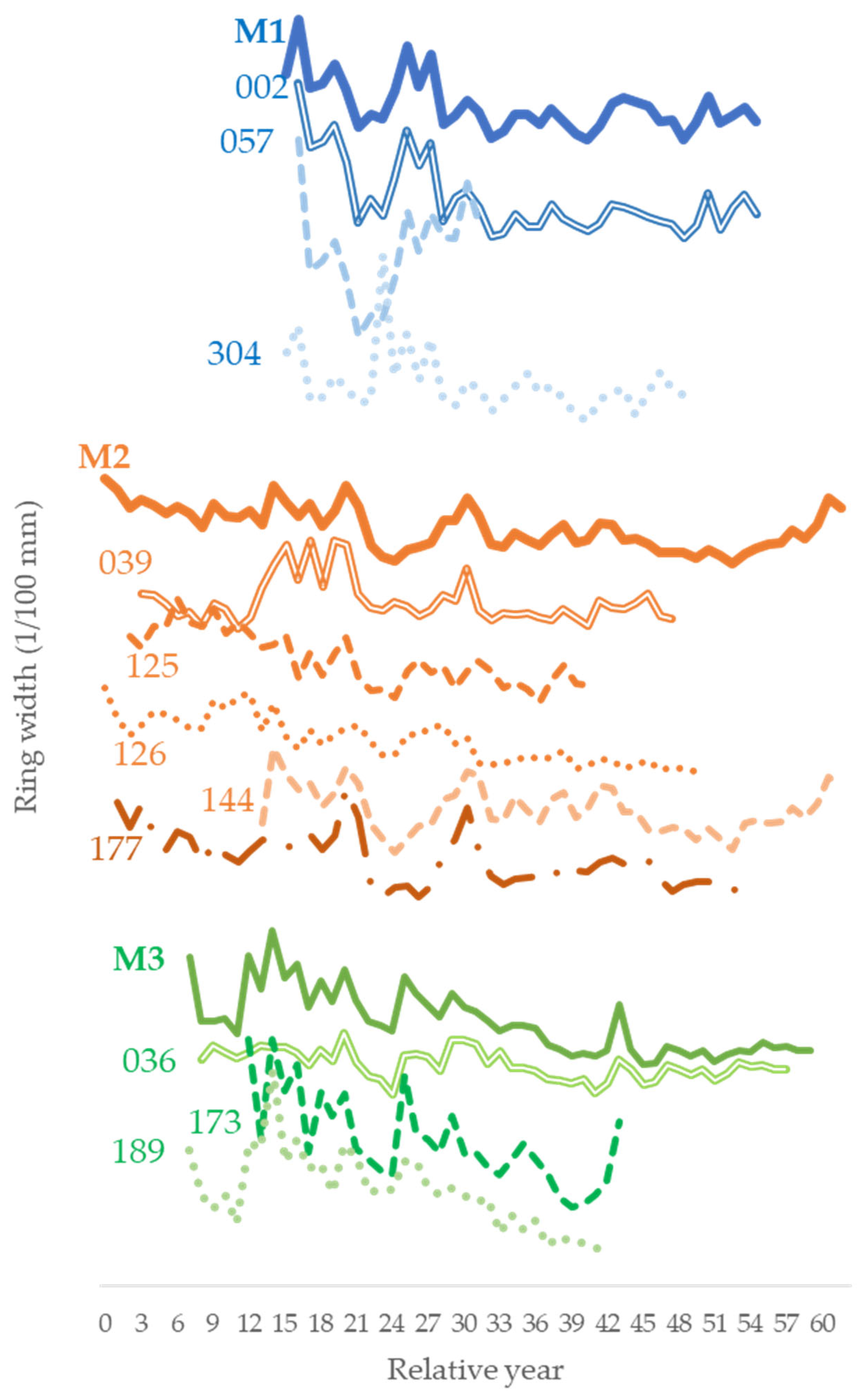
| M1 | 057 | 304 | M2 | 125 | 126 | 177 | 144 | M3 | 173 | 189 |
|---|---|---|---|---|---|---|---|---|---|---|
| 002 | Glk 93 GSL *** TV 2.7 TVBP 4.5 TVH 4.8 | Glk 81 GSL *** TV 4.9 TVBP 7.3 TVH 6.0 | 039 | Glk 75 GSL ** TV 4.1 TVBP 1.5 TVH 2.5 | Glk 70 GSL ** TV 1.6 TVBP 3.5 TVH 3.0 | Glk 72 GSL ** TV 5.1 TVBP 4.9 TVH 4.4 | Glk 62 GSL TV 4.3 TVBP 2.5 TVH 2.1 | 036 | Glk 68 GSL * TV 5.1 TVBP 3.9 TVH 3.7 | Glk 54 GSL TV 4.2 TVBP 3.2 TVH 1.2 |
| 057 | Glk 93 GSL *** TV 6.2 TVBP 3.4 TVH 10.5 | 125 | Glk 68 GSL * TV 7.1 TVBP 2.6 TVH 2.7 | Glk 74 GSL ** TV 2.2 TVBP 1.3 TVH 1.3 | Glk 83 GSL *** TV 3.2 TVBP 4.1 TVH 4.2 | 173 | Glk 68 GSL * TV 8.5 TVBP 2.7 TVH 2.6 | |||
| 126 | Glk 64 GSL * TV 4.3 TVBP 2.8 TVH 2.9 | Glk 78 GSL ** TV 4 TVBP 4.7 TVH 3.8 | ||||||||
| 177 | Glk 62 GSL TV 7.8 TVBP 2.3 TVH 2.1 |
| Pole | Selected Rings | Calibrated Dating (2σ) (Year BC) | ||
|---|---|---|---|---|
| 036 | 1–5 | 1106 1080 1055 | (1.0%) (1.1%) (93.3%) | 1096 1068 829 |
| 16–20 | 981 939 | (6.3%) (89.1%) | 947 802 | |
| 31–3 | 1108 1086 1058 883 | (2.1%) (2.6%) (81.8%) (8.9%) | 1091 1064 889 834 | |
| 46–50 | 976 935 | (3.7%) (91.7%) | 951 800 | |
| 050 | 1–5 | 1049 | (95.4%) | 832 |
| 13–17 | 982 940 | (6.8%) (88.6%) | 946 803 | |
| 23–27 | 922 | (95.4%) | 800 | |
| 126 | 1–3 | 1124 | (95.4%) | 897 |
| 14–16 | 1044 1017 | (1.5%) (93.9%) | 1032 827 | |
| 27–30 | 1008 | (95.4%) | 823 | |
| 189 | 1–3 | 993 | (95.4%) | 814 |
| 12–14 | 1005 | (95.4%) | 820 | |
| 23–25 | 990 | (95.4%) | 811 | |
| 304 | 1–5 | 1199 1131 | (9.3%) (86.1%) | 1141 926 |
| 16–20 | 1211 960 | (89.8%) (5.6%) | 967 930 | |
| 31–35 | 1045 1019 | (2.5%) (92.9%) | 1029 830 | |
Disclaimer/Publisher’s Note: The statements, opinions and data contained in all publications are solely those of the individual author(s) and contributor(s) and not of MDPI and/or the editor(s). MDPI and/or the editor(s) disclaim responsibility for any injury to people or property resulting from any ideas, methods, instructions or products referred to in the content. |
© 2025 by the authors. Licensee MDPI, Basel, Switzerland. This article is an open access article distributed under the terms and conditions of the Creative Commons Attribution (CC BY) license (https://creativecommons.org/licenses/by/4.0/).
Share and Cite
Romagnoli, M.; Sarlatto, M.; Tamantini, S.; Galotta, G.; Moscatelli, M.C.; Severi, E.; Barbaro, B. Tree-Ring Chronological Investigation on the Oak Poles of the Prehistoric Settlement of “Gran Carro” in Lake Bolsena, Central Italy: Landscape and Human Occupation. Land 2025, 14, 1147. https://doi.org/10.3390/land14061147
Romagnoli M, Sarlatto M, Tamantini S, Galotta G, Moscatelli MC, Severi E, Barbaro B. Tree-Ring Chronological Investigation on the Oak Poles of the Prehistoric Settlement of “Gran Carro” in Lake Bolsena, Central Italy: Landscape and Human Occupation. Land. 2025; 14(6):1147. https://doi.org/10.3390/land14061147
Chicago/Turabian StyleRomagnoli, Manuela, Mara Sarlatto, Swati Tamantini, Giulia Galotta, Maria Cristina Moscatelli, Egidio Severi, and Barbara Barbaro. 2025. "Tree-Ring Chronological Investigation on the Oak Poles of the Prehistoric Settlement of “Gran Carro” in Lake Bolsena, Central Italy: Landscape and Human Occupation" Land 14, no. 6: 1147. https://doi.org/10.3390/land14061147
APA StyleRomagnoli, M., Sarlatto, M., Tamantini, S., Galotta, G., Moscatelli, M. C., Severi, E., & Barbaro, B. (2025). Tree-Ring Chronological Investigation on the Oak Poles of the Prehistoric Settlement of “Gran Carro” in Lake Bolsena, Central Italy: Landscape and Human Occupation. Land, 14(6), 1147. https://doi.org/10.3390/land14061147