1. Introduction
Land use transformation driven by socioeconomic restructuring exhibits distinct phased characteristics, with Land Use/Cover Change (LUCC) studies demonstrating an evolutionary trajectory from natural ecosystems through agro-ecosystems to urban ecosystems under human intervention [
1]. Early developmental stages typically witness the conversion of pristine forests and wetlands into agricultural land, succeeded by urbanization processes where rural settlements and farmlands are progressively transformed into urban built-up areas [
2,
3]. In contemporary developing countries, particularly China as the largest exemplar, accelerated urbanization since the 1978 reforms has fundamentally reconfigured territorial spatial patterns through dual dynamics [
3,
4]: urban spatial expansion encroaching on rural areas via land acquisition, concurrent with rural depopulation causing developmental factor depletion and village-hollowing phenomena [
5,
6]. These intertwined processes have precipitated significant degradation of rural productive capacities and ecological functions, underscoring the urgent need for spatial planning system innovation to optimize land use configurations [
7,
8,
9]. The resultant scientific imperative involves establishing functional land classification frameworks that systematically inform territorial planning decision-making processes [
10,
11].
Land use function research has developed a systematic theoretical framework through sustained academic exploration [
12,
13]. The current theoretical paradigm systematically addresses three interconnected dimensions: connotation deconstruction, multi-dimensional evaluation criteria formulation, and spatial optimization pathway identification [
14,
15]. Central to this framework is the “production–living–ecological” (PLE) functional typology, grounded in the “Three-Life Functions” theoretical framework that categorizes spatial utilities according to their dominant purposes [
16,
17]. Specifically, production spaces serve as material production bases, living spaces support human habitation and social activities, while ecological spaces maintain ecosystem services and environmental security [
18,
19]. Empirical investigations typically employ composite indicator evaluation combined with land use type weighting for functional identification, subsequently applying geodetector models and spatial autocorrelation analysis (Moran’s I) to decipher multiscale evolutionary mechanisms [
20,
21]. These analyses systematically examine the dual influences of natural geographical constraints and socioeconomic drivers in shaping functional dynamics [
22,
23].
As China’s pioneering reform and opening-up region, Guangdong Province exhibits a 75.42% urbanization rate (2023), leading provincial-level regions in urbanization development [
24,
25]. Its accelerated economic growth and industrialization have intensified systemic transformations in human–land relationships, regional coordination patterns, and urban–rural structures, resulting in increasingly complex functional configurations and pronounced spatial differentiation [
25]. The concurrent pressures of urbanization and industrialization have particularly exacerbated structural conflicts between agricultural production, residential, and ecological conservation spaces. Investigating Guangdong’s “production–living–ecological” (PLE) spatial dynamics offers dual contributions: advancing regional coordination theory and informing China’s territorial spatial planning practices.
This study establishes a synergistic PLE evaluation framework through integrated theoretical–empirical methodology. Spatial econometric techniques systematically reveal spatiotemporal evolution patterns and functional interrelationships across Guangdong. Subsequent regional classification integrates resource endowments, locational advantages, economic capacity, and ecological thresholds to formulate differentiated development strategies. Three core questions guide the investigation: (1) spatiotemporal trajectory of PLE functional configurations; (2) interaction mechanisms between functional subsystems; and (3) sustainable pathways for functionally distinct zones.
2. Literature Review and Theoretical Analysis
Under the backdrop of accelerated global industrialization and urbanization, the efficient allocation of land resources and multi-functional development have emerged as core issues in the field of sustainable development [
15,
16]. Nations worldwide currently face dual challenges of shrinking agricultural production spaces and degrading ecosystem service functions caused by urban–rural construction land expansion [
18,
26]. This spatial competition pattern has prompted academic and planning communities to actively explore multi-objective collaborative spatial governance paradigms [
20]. International experience demonstrates that the early regional socioeconomic-oriented spatial planning exemplified by France has gradually evolved into comprehensive territorial governance systems like those in The Netherlands [
19,
21]. The “regulation–habitat–production–information–support” five-dimensional functional classification framework proposed by scholars such as De Groot as well as the “production–ecology–culture” tripartite spatial division theory developed by Lovell’s research team have laid crucial theoretical foundations for multiscale spatial functional analysis [
27,
28].
International scholars have explored urban–rural relationships based on the differentiation of spatial functions. Theoretical discussions on urban–rural relationships in academia originated from the social reality of intensified urban–rural separation following the Industrial Revolution and have deepened alongside practices such as globalization, urbanization, and rural revitalization [
5,
7,
29]. Early studies often viewed urban and rural areas as opposing systems. Lewis’s “Dual Economy Model” posited structural contradictions between traditional agricultural sectors and modern industrial sectors, asserting that the transfer of rural surplus labor to cities was an inevitable developmental path [
30]. While this theory provided a rationale for industrialization in developing countries, it faced criticism for overlooking the endogenous dynamics of rural areas [
1,
2].
With the advancement of globalization and urbanization, both developed and developing countries have explored context-specific strategies to promote rural revitalization, rural restructuring, and community development, thereby better supporting healthy urban construction and urbanization. Post 1980s, scholars began emphasizing the complexity of urban–rural element flows. McGee proposed the “Desakota” concept, highlighting hybrid development patterns in peri-urban areas of Southeast Asia [
31]. In recent years, sustainable development principles have redirected urban–rural studies toward synergistic coexistence. UN-Habitat’s “Urban–Rural Continuum” framework emphasizes infrastructure sharing, ecological co-governance, and cultural connectivity. Consequently, land use functional evaluation has emerged as a critical analytical tool [
32].
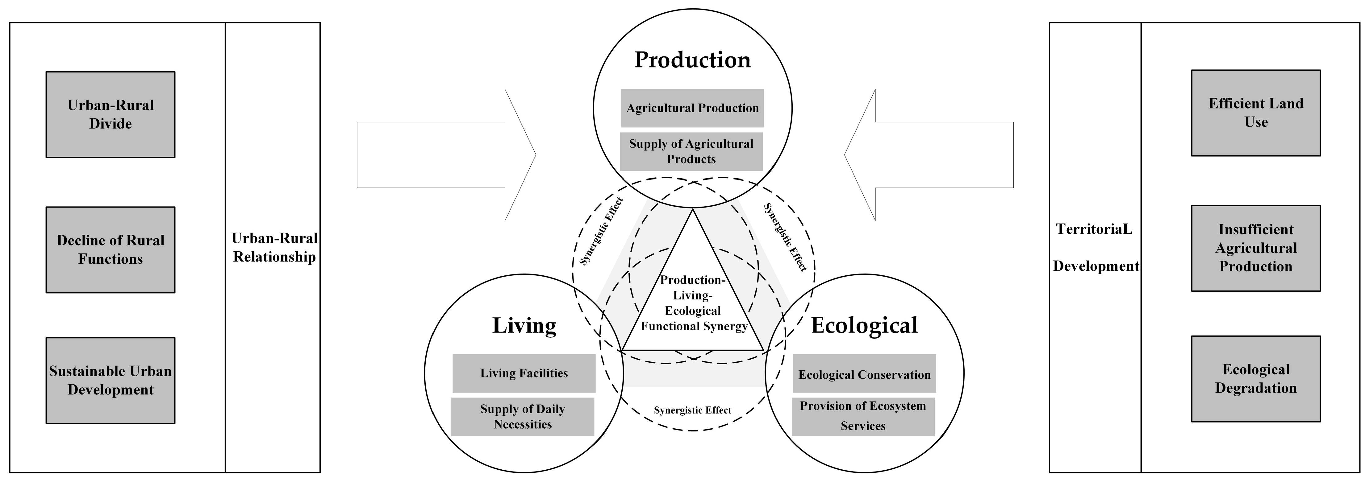
In the context of international academic discourse, Chinese scholars have developed a localized innovative theoretical system using a “production–living–ecological” (PLE) trinity of spatial functions (
Figure 1). By conducting functional evaluations of spatial land use, this framework provides practical foundations for promoting urban construction and rural restructuring [
1,
2]. This theoretical paradigm transcends conventional unidimensional functional classifications, deconstructing land use composite functions into three interactive dimensions: (1) productive spaces serving as economic activity platforms centered on agricultural and industrial production [
16,
17,
18]; (2) living spaces functioning as sociocultural complexes accommodating residential, consumptive, and recreational activities [
22,
23]; and (3) ecological spaces constituting natural matrices essential for maintaining environmental security and biodiversity conservation [
25]. These components form a dynamically coupled complex system characterized by reciprocal constraints and synergies wherein: productive spaces sustain living space development through material provisioning even though their excessive expansion induces ecological space fragmentation; ecological carrying capacity fundamentally constrains agricultural productivity and human settlement quality; and the intensification patterns of living spaces reciprocally influence productive spatial configurations and ecological preservation strategies [
33,
34]. Cross-cultural empirical studies by Wang et al. demonstrate this framework’s analytical efficacy, having been successfully operationalized not only in China’s Fuzhou urban transformation research but also validated through comparative international cases, including Saskatoon, Canada, thereby confirming its transnational applicability in spatial governance studies [
35].
The “production–living–ecological” (PLE) framework has become a vital tool for analyzing human–environment interactions [
34]. Global researchers increasingly use quantitative models to explore its links with UN Sustainable Development Goals (SDGs), particularly through synergy–tradeoff relationships. Land resources form the physical foundation of PLE functions [
36]. Their multi-dimensional nature directly shapes biodiversity conservation and climate responses. Simultaneously, these resources indirectly enable sustainable energy and food systems [
37]. These studies confirm that spatial governance policies require new approaches. The framework shows strong potential in three areas: optimizing urban–rural planning, designing ecological compensation mechanisms, and improving territorial spatial management [
38].
Methodological research has established core techniques, including geodetector models, spatial autocorrelation analysis, and LISA clustering [
15]. Studies focus on three key areas: building functional evaluation models, analyzing drivers, and simulating spatiotemporal changes [
18]. For identifying “production–living–ecological” (PLE) functions, two main methods are used. First, quantitative approaches create evaluation systems to measure production, living, and ecological functions across administrative units and then use spatial analysis to map variations [
19]. Second, qualitative methods classify PLE functions by dominant land use types and detect spatial patterns [
20,
21]. While both use spatial autocorrelation analysis, they differ in focus: quantitative methods target statistical comparisons of administrative regions, whereas qualitative methods emphasize land parcel typologies.
Most existing studies on “production–living–ecological” (PLE) spatial relationships primarily focus on the agglomeration patterns of PLE spaces, while paying limited attention to interactions between distinct PLE zones. However, understanding these interactions is critical for coordinating and optimizing PLE spatial configurations. This study systematically investigates PLE agglomeration from a multi-functional zoning perspective. Through analyzing dominant functions at the county level and examining tradeoffs/synergies between functions, it proposes actionable strategies for harmonizing land use planning and functional optimization.
3. Materials and Methods
3.1. Study Area
Guangdong Province is located in the southernmost part of mainland China, with a land area between latitude 20°09′~25°31′ north and longitude 109°45′~117°20′ east, with 21 prefectural-level cities, 65 municipal districts, 20 county-level cities, 34 counties, and 3 autonomous counties (
Figure 2). As the frontier of reform and of opening up, Guangdong Province has undergone a great transformation in human–land relations, regional relations, and land use patterns, leading to the complexity of geographical functions and the differentiation of dominant functions. Guangdong Province consists of the alluvial plains of the Pearl River Delta and the hilly areas of the mountains and hills of northwestern Guangdong, with a high level of urbanization in the Pearl River Delta region and rural development that has entered the late stage of urban–rural integration and development; the remote mountainous areas of northwestern Guangdong are still in the stage of urban–rural segmentation. Therefore, analyzing the characteristics of the spatial and temporal changes of county rural functions, with Guangdong Province as the research object, and correctly identifying different types of regional functions have positive significance for the targeted implementation of spatial control and the promotion of regional sustainable development.
3.2. Research Data Sources
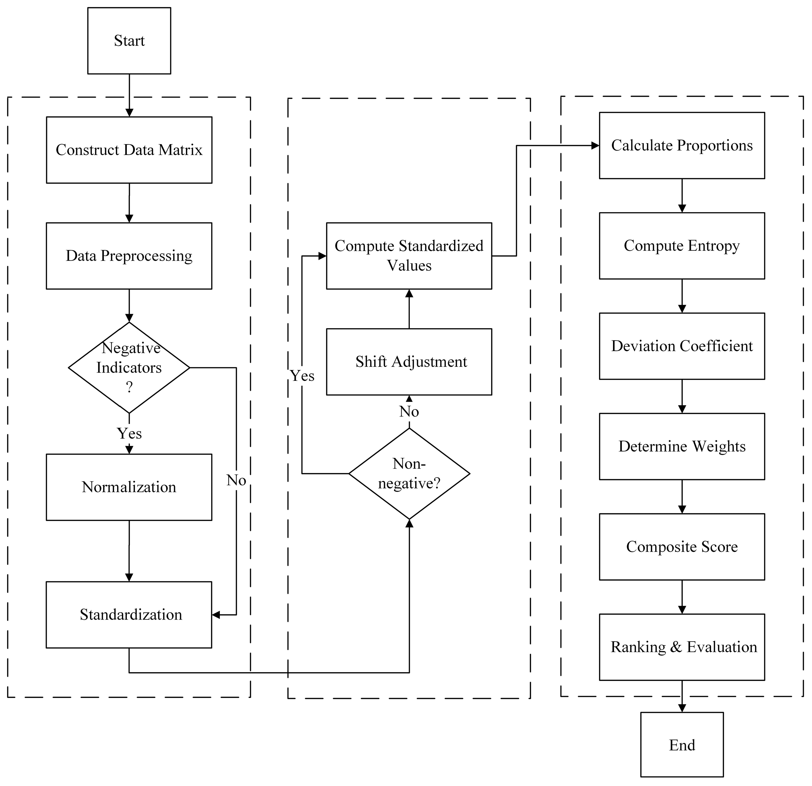
Combining the definition of the connotation and attributes of county rural functions with the existing studies and the relevant theories, the conceptual characteristics of county rural functions are elaborated, on the basis of which the county rural functions of Guangdong Province are defined from the perspectives of production, living, ecology, etc., by using the actual situation of Guangdong Province and by considering the availability of data. The indicators are selected to establish the evaluation system of the county rural functions at the scale of the township, and the entropy and hierarchical analyses are applied to determine the weights of the indicators. The entropy value method and hierarchical analysis method are used to determine the weights of the indicators. On the basis of data standardization, the weighted summation method was applied to calculate the 2010, 2014, and 2019 county rural function indices.
The study area was determined based on the administrative county list from the Guangdong Statistical Yearbook, combined with its definition standards for “rural classification”. After excluding fully urbanized municipal districts and regions with significant missing data (e.g., districts or counties), 67 research units were ultimately selected, including county-level cities, counties, and agriculture-related municipal districts.
Socioeconomic data were obtained from the Guangdong Statistical Yearbook (2010–2019), with missing values in specific years supplemented by interpolation methods; Normalized Difference Vegetation Index (NDVI) data were sourced from the National Ecological Science Data Center; and land use data were acquired from the Guangdong Provincial Data Open Platform (
Table 1).
The provincial statistical yearbook data and Guangdong Province’s data openness platform data have undergone validation and verification, covering comprehensive indicators across agriculture, livelihoods, and ecology for all 67 counties (cities) in Guangdong Province. The study specifically selected three-period panel data from 2010 (base year), 2014 (mid-term year), and 2019 (current status year) that feature complete five-year intervals and have been validated by provincial statistical authorities. This selection not only fulfills the requirements for long-cycle evolution analysis of rural functions but also circumvents data heterogeneity issues arising from adjustments in statistical caliber. NDVI data, which accurately reflect vegetation changes, serve as crucial evidence for assessing ecological functions.
3.3. Research Methodology
3.3.1. Indicator System for Evaluation of County Rural Functions
County rural functions reflect the role played by social and economic activities within a certain geographical area. Drawing on relevant research, this study proposes a system based on the “production–living–ecological” (PLE) functions to build an evaluation index system for county rural functions in Guangdong Province, which consists of three aspects: the production function, living function, and ecological function. A quantity of 10 indicators are selected to quantitatively reflect the development level of the three functions (
Table 2).
The production function refers to the function of land as an object of labor to directly acquire or use land as a carrier for social production to produce various products and services [
39,
40]. The study mainly focuses on the function of the countryside in agricultural production, and based on the availability of data and the reality, the study chooses four indicators to reflect the agricultural production function: index of land reclamation; agriculture, forestry, livestock, and fisheries output per capita; per capita grain availability; and mechanization level [
19,
23,
34]. The study chooses three indicators to reflect the ecological function: vegetation cover; water area per capita; and green space per capita [
1,
2,
8]. The living function refers to the ability to provide basic living security for human survival and development, which mainly includes social security, social development, and other capabilities. The study chooses three indicators to reflect the living function: income level of the rural population; medical and health conditions; and educational conditions [
41,
42].
3.3.2. Methodology for Measuring the Level of Functioning of County Villages
The units between the indicators are not uniform, so after the study standardized the indicators, the entropy value method was used to calculate each function of the county’s rural function [
43,
44], and the specific formulas are as follows:
where
is the standardized value of the
th evaluation index for the sample of the
th administrative county (district);
represents the weight of the
th index;
represents the rural function index of administrative county (district)
, with the value ranging from 0 to 1. The larger the value, the stronger the function (
Figure 3).
In this study, the production function, ecological function, and living function of the samples in each administrative county (district) were processed using natural breakpoints that were defined as three levels from low to high, as Level I, Level II, and Level III, respectively.
3.3.3. Spatial Concentration of Functions in the County Countryside
In this paper, the Gini coefficient is used to reflect the degree of concentration of various types of functions in the spatial layout of the county countryside, which is calculated by the formula [
45,
46]:
In the formula, the value of indicates the value of the m-function of the sample; indicates the total value of the m-function; n indicates the number of villages; and indicates the Gini coefficient of the m-function, with the value between 0 and 1—the larger the value indicates the more centralized, and vice versa the more dispersed.
3.3.4. Identification of Functional Types of County Villages
The study draws on the research methodology of Yang and Tan regarding functional zoning classification [
47,
48]. Due to the differences in geographic conditions, socioeconomic conditions, etc., in different county units (districts), the advantageous dominant function has a large difference in the long-term development process [
22]. For the identification of different geographical dominant functions, it can show the transformation of the strategy of each region in the development process. The calculation steps are as follows:
First, the relationship between the values of the three functions of production, ecology, and living of the sample in each county (district) and the average value of the function is calculated to determine whether the function is a dominant function.
where
is the difference between the average value of
function and the function of each county (district) sample. If
> 0, it means that the function is dominant; if
≤ 0, it is a non-dominant function.
Next, the function type of each county (district) is determined. If the number of dominant functions is 0, it is a weakly integrated type; if the dominant function is 1, it is that function type; if the dominant function is 2, it is a dual function type; if the dominant function is 3, it is a strongly integrated type. Among them, the single function type is divided into 3 types: production function type, ecological function type, and living function type; and the dual function type is divided into 3 types: production–ecological type, production–living type, and living–ecological type.
4. Results
4.1. Evaluation of Functionality Index of Rural Counties in Guangdong Province
Formula (1)-derived rural function indices with hierarchical processing, combined with Formula (2)-derived spatial Gini coefficients, reveal significant spatiotemporal disparities in functional distributions across Guangdong counties (
Figure 4).
4.1.1. Evaluation of the Production Function Index
Based on the analysis of the time changes of the county rural production function index (
Table 3), the rural production function in Guangdong Province during the period of 2010–2019 showed significant stage characteristics: the average level experienced a non-linear change of “slow rise—sudden decline”, increasing slightly from 0.27 in 2010 to 0.28 in 2014 (with an average annual growth rate of 0.93%) and then declining sharply to 0.14 in 2019 (with an average annual decline of 12.28%). In terms of spatial differentiation, the Gini coefficient continued to fall from 0.49 in 2010 to 0.12 in 2019, indicating that the spatial distribution of production functions had transitioned from high agglomeration to equalization.
The changes of the spatial pattern revealed in
Figure 1 further confirms the above findings: in 2010–2014, the hierarchy of production functions showed strong path-dependent characteristics, with high-value areas (level III and above) stably distributed in the southern Pearl River Delta Plain and Leizhou Peninsula plateau (Zhanjiang). A large spatial reconfiguration took place in 2014–2019, with the many level II areas in the northern region changing into level I areas and the localized weakening of production functions, with Xuwen (Zhanjiang) and other counties in western Guangdong strengthening agricultural specialization against the trend. Xuwen (Zhanjiang), Leizhou (Zhanjiang), and other counties in western Guangdong are bucking the trend of intensifying agricultural specialization and have become significant high-value nuclei. This spatial differentiation of “southern consolidation and northern decline” is highly coupled with the topographic gradient of Guangdong Province: the southern Pearl River Delta Plain and Leizhou Peninsula plateau (Zhanjiang) form a highland of agricultural production suitability by virtue of fertile alluvial soil and good water and heat conditions; the northern Nanling Mountains are affected by the topographic locking effect, with a high degree of fragmentation of arable land and high content of organic matter in soils, which constitutes a natural geographical barrier to the development of agriculture. It is worth noting that the core contradiction of “high in the south and low in the north” in the production function space reveals the rigid constraints of topographic elements in the changes of rural functions.
4.1.2. Evaluation of the Ecological Function Index
From
Table 4—the temporal changes of ecological function—the average value of the ecological function experienced a “U-shaped” turn when it dropped to 0.18 from 2010 to 2014 and then rebounded strongly after 2014 to 0.23 in 2019. The spatial changes of the ecological function show that the spatial Gini coefficient of the ecological function in Guangdong Province’s counties and villages exhibited an upward trend between 2010 and 2019. The spatial Gini coefficient rose from 0.13 in 2010 to 0.18 in 2014 and to 0.44 in 2019, revealing the transforming characteristics of ecological functions from balanced distribution to core agglomeration.
Figure 1 shows a significant core–edge structural strengthening trend: the high-value zone (level III) was scattered during 2010–2014, while in 2019, it formed a cluster of ecological services centered on the Pearl River Delta urban agglomerations—14 county units such as Sihui (Zhaoqing), Chenghai (Shantou), Xinhui (Jiangmen), and so on, constitute a continuous high-value zone. Overall, the ecological functions of the high-level county units have a tendency to gather at the center, which is related to the regional ecological importance of Guangdong Province in recent years, as the center of the region has an advantage in terms of funding and so on. There are fewer ecological high-level county units in the north, which is related to the topography and geomorphology, as well as to the local limestone landscape—which is not conducive to ecological restoration. In the south, due to the agricultural activity needed in order to increase agricultural productivity, the excessive use of chemical fertilizers and pesticides has resulted in ecological damage. On the whole, the ecological function of Guangdong Province is generally developing well, and the construction of ecology has achieved certain results. However, there is still much room for development, especially in the ecologically vulnerable areas in the north and the polluted areas of agricultural production in the south.
4.1.3. Evaluation of the Living Function Index
In terms of the temporal changes of the living function, the living function index has experienced an accelerated decay process: the mean value of the state function decreased from 0.31 in 2010 to 0.23 in 2014 and then to 0.09 in 2019 (
Table 5). The number of areas with medium and high values of the living function has decreased, and the living function has tended to become imbalanced. In terms of the spatial changes of the living function, the spatial Gini coefficient of the living function in the rural counties of Guangdong Province showed a trend of first increase and then decrease from 2010 to 2019, revealing that the spatial mismatch between the supply of the living function and the demand continues to intensify. The spatial differentiation shows two phases of “agglomeration–diffusion” characterized by the spatial Gini coefficient rising from 0.76 in 2010 to 0.85 in 2014 and then dropping to 0.05 and insignificant, indicating that the spatial autocorrelation pattern has been fundamentally reversed.
Figure 1 shows that there is little change in the functional class of rural living in counties of Guangdong Province from 2010 to 2014 or from 2014 to 2019. This is mainly due to the fact that Guangdong Province has advantages in manufacturing and service industries, attracting a large number of laborers from other provinces, but the basic public services are unable to meet the rapid population growth, forming a vicious cycle of “population concentration–service dilution”.
4.2. Classification of Functional Types of Rural Functions in Guangdong Province Counties
Identified transformation and functional types should refer to
Figure 5. For the identification of dominant functions, it is the basis for the study of regional development differentiation. According to Equation (3) there are eight functional types in Guangdong Province (
Table 6), and their change trajectories show two patterns:
1. The degree of functional synergy continues to be optimized. (1) The number of weakly integrated counties plummeted from 23 to 19 between 2010 and 2019, while the number of dual function counties increased from 16 to 29. (2) This indicates that driven by the new urbanization strategy, the development of county units is transforming from inefficient balance to specialized synergy.
2. The polarization effect of ecological functions has been highlighted. The proportion of ecologically dominant counties (including single ecological function type, production–ecological function type and living–ecological function type) reaches 65.3%. In contrast, production-led and living-led function types show a declining trend, reflecting the systematic decline of the “agricultural production–living” function in the process of rapid industrialization.
4.2.1. Weakly Integrated
The proportion of weakly integrated county unit types shows a decreasing trend, going from 34.33% in 2010 to 35.82% in 2014 and down to 28.36% in 2019. This weakly integrated type is characterized by the fact that none of the three functions is advantageous, and there is no obvious dominant function or other characteristics. From
Figure 2, it can be seen that the main height of this type of area is clustered in the mountains of the Nanling Mountains in northern Guangdong. These counties generally have the “three low dilemmas”: low functional synergy, low development potential, and low ecological resilience. The formation mechanism of this county unit type has typical geographic constraints:
1. Topographic Constraints—Agricultural Production Dilemma: As integral components of the Nanling Mountain Range, the mountainous and hilly terrains predominantly distributed in north-central Guangdong Province belong to the Liangguang Hills of the Southeastern Hills system. The elevated topography dominated by mountains results in limited arable land unsuitable for mechanized production. Extensive limestone distributions, combined with low soil organic matter content and inadequate water resources, collectively contribute to suboptimal agricultural infrastructure, inferior cultivated land quality, and diminished agricultural productivity.
2. Geomorphological Constraints—Ecological Vulnerability Cycle: Most counties in this category exhibit karst landform characteristics, rendering them prone to severe ecological degradation such as soil erosion. The inherent geological vulnerability coupled with challenging ecological restoration processes leads to weakened ecosystem functionality.
3. Locational Constraints—Developmental Momentum Deficiency: These inland counties demonstrate significant developmental disparities compared with the prosperous Pearl River Delta region. Their economic backwardness manifests through inadequate infrastructure development and insufficient provision of basic public services. This spatial disadvantage has engendered a vicious cycle characterized by “infrastructure lag—human capital outflow—economic vitality decline”, perpetuating regional underdevelopment.
4.2.2. Single Function Types
There are three single function types: production function type, living function type, and ecological function type county units. Based on the analysis of the changes law of functional types, the single function county units of rural counties in Guangdong Province show a differentiated development trend, in which the number and percentage of ecological county units show a rising trend; the number and percentage of production function type and living function type county units show a decreasing trend.
The ecological function type county units have distinctive functional characteristics, with clear ecological protection as the direction of development, and are clustered in the northern mountainous and riverine areas as a whole. In recent years, the county has paid attention to and invested in the ecology of the region, and reformed the ecologically fragile areas to improve the ecological function as a whole. For this type of county unit to exist in the future, it should continue to strengthen the protection of the environment on the basis of the development of agricultural production or tourism and other industries to improve farmers’ incomes. Agricultural production can develop a forest economy, cultivation of traditional Chinese medicinal herbs, wild mushroom cultivation, ecological breeding, etc.; tourism can attract the population of the surrounding cities to develop eco-tourism.
For production function type county units, by 2019 only two areas remained, Luoding (Yunfu) City and Xinyi (Maoming) City. This county unit type has fewer numbers, but the development objectives are clear, and the future also focuses on agricultural production.
4.2.3. Dual Function Types
There are three dual function types: production–living, production–ecological, and living–ecological. The proportion of county units of the production–living type shows a downward trend; the proportion of county units of the production–ecological function type and the living–ecological function type shows a rising trend. Overall, the proportion of ecologically superior county units gradually rises. A pattern of coordinated development of the single and dual function types and the production, living, and ecological functions is gradually formed.
The production–ecological function type is concentrated in the southern part of Guangdong Province, where the terrain of the rivers is flat, the hydrothermal conditions are good for agricultural production, and the ecological environment in the area where many rivers pass through is good, thus making it easy to form a pattern of coordinated development of agricultural production and ecology. In the future, it is still necessary to emphasize the coordination between agricultural production and ecology, and at the same time improve the living conditions in the region to make up for the shortcomings of the living function.
The living–ecological function type is mainly concentrated in the center of Guangdong Province, which is economically more developed, provides good infrastructure, has advantages in living conditions, and is close to densely populated and economically developed areas such as Guangzhou and Zhuhai, which require it to undertake the ecological functions of these cities. Therefore, the county units of the living–ecological function type should emphasize the maintenance and enhancement of the ecological function in the future and rely on the ecological environment to develop eco-tourism and other industries in order to improve the ecological benefits.
The production–living functional type is a composite regional type dominated by the synergy between agricultural production and residential living functions, with relatively weakened ecological functions. It belongs to a transitional form of dual “production–living” synergy within the “production–living–ecological” (PLE) spaces. Its core characteristic is the high geographical nesting of agricultural production spaces and settlement living spaces; however, its lack of ecological buffer zones leads to insufficient system resilience. This function type is gradually disappearing in Guangdong Province.
4.2.4. Strongly Integrated
The proportion of strongly integrated county unit types shows a decreasing trend, with 12 in 2010 falling to 3 in 2019. This type of county unit is characterized by a balanced development of agricultural production functions, living functions, and ecological functions, and the overall development level of each function is strong. In 2019, there were only three strongly integrated county units—Boro County, Haifeng County, and Enping City. Most of the county units of this type are “by the mountains and by the water”, are backed by big mountains, are located in the lower reaches of many big rivers, and have wide plains and fertile soils that have good conditions for agricultural production and ecological industry development. At the same time, these county units are adjacent to large cities, and because they are located around the core areas of urban agglomerations, they have better living conditions due to the heavy construction and investment in infrastructure and public facilities.
4.3. Functional Shift of Rural Areas in Guangdong Province
On the whole, between 2010 and 2019, the overall structure of county rural functions in Guangdong Province changed relatively significantly. The overall performance is characterized by an increase in ecological function type county units and a decrease in production function type county units and living function type county units (
Figure 6).
Eight county units experienced having production function advantages turn into disadvantages. These counties are mainly distributed in two types of areas: one is mountainous areas where soil erosion is a serious problem, resulting in the transformation of the production function; the second is close to economically developed areas where the loss of a labor force and cropland abandonment is caused by the transformation of the production function.
The transformation of 18 county units from an ecological function type disadvantage to an advantage is related to the importance attached to the ecological environment in recent years; the strengthening of inputs for the enhancement of ecological functions and the strengthening of ecological function construction have obviously had significant effects. In the future, we can also more actively explore the cultivation of ecological non-agricultural industries to increase farmers’ incomes.
The observed decline in living functionality across 12 southern county-level units (CLUs) can be attributed to two interrelated mechanisms: the first mechanism is due to the expansion of the central urban agglomeration, which strengthens the city center and improves the infrastructure of the surrounding areas, reducing the original area of infrastructure investment and maintenance. The second mechanism is the loss of population, which correspondingly reduces the investment and maintenance of public services in the region.
The production–living functions of 29 county-level units have not undergone significant changes. The stability of these functions is primarily attributed to: (1) the continued implementation of ecological red line control policies; and (2) the path dependence effect in the transformation of traditional industries.
5. Discussion
The differentiated interactions between humans and the environment, mediated through material–energy exchange processes, shape the spatial differentiation patterns of regional functions [
6,
49]. As the most direct spatial manifestation of human–land relationships, land use systems satisfy multi-dimensional human demands through differentiated allocation of resource elements. The ecosystem services they provide exhibit significant spatial gradient effects due to typological heterogeneity, a spatial attribute that can be characterized as the “production–living–ecological” (PLE) composite function system [
17,
18]. Notably, policy regulation and gradient industrial relocation, as typical external drivers, exert significant intervention effects on PLE functional zoning by altering land element allocation efficiency and spatial competitive relationships [
50,
51]. This study focuses on investigating the synergistic mechanisms of these two spatial governance tools: on one hand, analyzing how production factor reorganization induced by industrial relocation triggers functional spatial restructuring; on the other hand, revealing the transmission pathways through which policy-oriented regulatory rules and benefit distribution mechanisms optimize the trinity of functional spaces. Ultimately, this study proposes territorial spatial governance recommendations based on a coupling perspective of “factor flow–institutional response”.
5.1. The Driving Role of Policy Interventions in Rural Function Transformation
First, the average ecological function index and spatial agglomeration intensity (Moran’s I) of counties in Guangdong Province showed significant improvement from 2014 to 2019, indicating phased achievements in ecological protection and restoration projects. However, attention should be paid to the synchronous decline in production and living functions. This phenomenon may stem from policy interventions that substantially increased the scale of ecological land use, triggering spatial displacement effects caused by ecological land expansion. In 2016, Guangdong Province issued the “Implementation Opinions on Accelerating the Promotion of Ecological Civilization Construction”, with the core objectives of establishing the Pearl River Delta as China’s first demonstration zone for green ecological city clusters, fortifying the Nanling ecological security barrier in Eastern, Western, and Northern Guangdong, and ultimately achieving dynamic alignment between ecological civilization construction and the comprehensive realization of a moderately prosperous society.
Second, ecological functions in 18 county-level units have transitioned from disadvantaged to advantageous status, with most dual function type areas exhibiting ecological advantages in at least one domain [
8]. This demonstrates a gradual evolution toward synergistic relationships between ecological functions and living/production functions. The significant increase in dual function type areas is closely linked to ecological environment improvements, which have enhanced original production functions and elevated production quality. This further confirms that ecological, production, and living functions are not mutually exclusive but can achieve coordinated development through the “Three-Life Integration” strategy (integrating ecology, production, and livelihood). Consistent with most research findings, ecological functions can synergize with other functional systems and even catalyze their development to some extent [
8,
52,
53].
Guangdong Province’s emphasis on ecological conservation has driven significant shifts in land use toward ecological functions, markedly enhancing ecosystem services across regions. In 2023, the provincial government formalized this commitment through the Decision of the CPC Guangdong Provincial Committee on Deepening the Construction of Green and Beautiful Guangdong Ecology, which enshrines ecological priority and green development as core governance principles. Guided by this framework, rural revitalization strategies at the county level now adhere to a governance logic of “Ecological Prioritization—Functional Restructuring—Value Transformation”, systematically advancing a three-tiered development model.
First, foundational ecological restoration initiatives are being prioritized, with the integration of Ecosystem Service Value (ESV) accounting into fiscal transfer payment criteria and the implementation of spatially differentiated ecological compensation mechanisms. Concurrently, ecological industrialization efforts are gaining momentum through the development of specialized tourism products such as karst landscape research expeditions, cave exploration programs, and geological observation facilities, supported by low-impact infrastructure like elevated walkways designed to minimize environmental disruption. Furthermore, regional coordination mechanisms are being innovated to address cross-jurisdictional challenges, exemplified by the establishment of a “Downstream Pearl River Delta—Upstream Ecology” horizontal compensation framework that aligns ecological rights and responsibilities across administrative boundaries.
This integrated approach demonstrates how ecological imperatives can synergize with socioeconomic development, transforming conservation efforts into drivers of high-quality growth while maintaining alignment with Guangdong’s strategic vision of harmonizing ecological, productive, and living functions.
5.2. Pathway Optimization for Industrial Restructuring and Functional Synergy
Guangdong’s industrial restructuring has profoundly reshaped the regional land use functional pattern. As China’s reform and opening-up frontier, the province initially relied on labor-intensive industrial clusters and industrialization-prioritized strategies, attracting massive migrant inflows. The population surge and extensive development directly triggered triple functional imbalances: (1) ecological function degradation from 2010 to 2014; (2) continuous decline in residential functions from 2010 to 2019, where urban construction lagged behind population growth, exacerbating “urban diseases” like traffic congestion and public service shortages; and (3) persistent agricultural production decline from 2010 to 2019, with a rural labor exodus leading to farmland abandonment and a “non-grain cultivation trend” in traditional agricultural strongholds like Boluo County and Leizhou.
The functional role reversal at the county level proves particularly emblematic [
8]. Originally, agriculture-dominant counties faced systemic challenges. Inadequate industrial transfer support mechanisms trapped them in a vicious cycle [
5]. Specifically, insufficient residential facilities constrained population concentration [
53]; low land development returns restricted infrastructure investment; and weak industrial attractiveness worsened fiscal constraints. Ultimately, their residential and agricultural functions transformed. These comparative advantages became structural disadvantages.
As a forefront of China’s reform and opening up, as well as being a key engine of economic development, Guangdong Province has surpassed the 75% urbanization rate threshold of modernization, establishing a regional development pattern with mega-scale economic capacity [
24]. Under the new normal of population mobility, leveraging its industrial agglomeration advantages and institutional innovation vitality, the province will continue to exert strong siphoning effects, maintaining a long-term trend of sustained influx of external populations [
54,
55,
56].
Regarding production factor allocation: Through deepening institutional innovations in “residential reform + industrial reform” (marked by Nanhai District of Foshan pioneering China’s first collectively owned commercial construction land market entry), the province has established a land value-added income feedback mechanism, effectively resolving the mismatches in “human–land–capital” elements.
In terms of life-quality enhancement: By constructing numerous provincial-level modern agricultural industrial parks, Guangdong has cultivated diversified integrated formats combining “agriculture + cultural tourism + wellness”, promoting a two-way flow of urban–rural elements and significantly improving rural population carrying capacity.
5.3. Limitations and Future Research Directions
This study applies the “Three-Life Functions” theoretical framework to analyze rural function development patterns, using county-level units in Guangdong Province as the basic analytical unit. It provides spatially heterogeneous evidence for macro-policy formulation. However, the research requires further refinement due to the following constraints:
This study employs county-level statistical data to construct an analytical framework. While effective in revealing macro-level trends of regional functional evolution, it suffers from dual limitations. First, inadequate spatial resolution obscures functional differentiation characteristics at township and village scales. Second, restricted indicator dimensions limit the interpretation of micro-level processes. To address these issues, a three-tiered optimization pathway is proposed. Subsequent efforts should integrate multi-source heterogeneous data—including Landsat remote sensing imagery, mobile communication signaling data, and geographic Points of Interest (POI) data. This integration enables refined analysis at the township scale, ultimately generating a spatiotemporally continuous classification framework for rural function patterns.
6. Conclusions
On the basis of constructing the evaluation index system of county regional functions in Guangdong Province, this paper analyzes the characteristics of county units’ rural functions and their spatial and temporal shifts in Guangdong Province from 2010 to 2019, and the main conclusions are as follows.
(1) The heterogeneous changes of the functional dimensions of rural counties in Guangdong Province is notable. From 2010–2019, the production function of rural counties in Guangdong Province gradually weakened, showing a pattern of “solid south and declining north”, with the production function in the northern part of the country gradually weakening. The ecological function rose, mainly due to the large increase in the number of high-value zones. Most of the high-value zones are close to the central city circle, showing the characteristic of “center–periphery”, with a tendency of strengthening. The living function experienced a systematic collapse, with a large number of high-value zones decreasing and some medium-value zones and most high-value zones being adjacent to the central city circle.
(2) The structural transformation of rural function types in counties of Guangdong Province is also notable. There are mainly eight function types: the weakly integrated, production function, ecological function, living function, production–ecological function, living–ecological function, production–living function, and the strongly integrated type. From 2010 to 2019, the number of weakly integrated and single function types decreased, and the scope of ecological function type areas gradually expanded, indicating that Guangdong Province had paid attention to and achieved certain results in ecological construction.
(3) The territorial functions of counties and villages in Guangdong Province are strongly resource dependent. The production function advantageous areas are mainly in the plains with flat topography and at the downstream areas of many big rivers, with suitable water and heat conditions and topographic advantages. The ecological function advantageous areas have a wider range of expansion areas, depending firstly on the mountainous and hilly terrain and the many rivers in Guangdong Province and secondly on Guangdong Province’s investment in ecological protection.


