Article

Geotourism and Local Development in Rural Areas: Geomorphosites as Geotouristic Resources in Sierras de la Paramera y Serrota, Spain

by
Rosa María Ruiz-Pedrosa
* and
Enrique Serrano
PANGEA Research Group, Geography Department, Universidad de Valladolid, 47011 Valladolid, Spain
*
Author to whom correspondence should be addressed.
Land 2025, 14(5), 982; https://doi.org/10.3390/land14050982
Submission received: 6 March 2025 / Revised: 24 April 2025 / Accepted: 28 April 2025 / Published: 2 May 2025

Abstract

:
Geomorphosites include all those places of abiotic heritage that are important for understanding the Earth’s history, with a landscape and territorial component. These places may not have high scientific value at an international, national, or regional scale, but they hold local value due to their connection to the territory, environmental and cultural legacy, and their link to the populations that inhabit them, especially in Natural Protected Areas (NPAs) where there is already recognition of natural heritage but not geomorphological heritage. The first objective of this work was the recognition of geomorphological heritage, for which an inventory of geomorphosites in the NPA Sierras de la Paramera and la Serrota was developed. The potential of these sites is currently diminished by the lack of recognition of geotourism, with no proper integration of geomorphosites in the planning of NPAs in Spain, particularly in Castilla y León, where the study area was located. This work proposes a methodology for evaluating the potential use of the inventoried geomorphosites, focused on their geotourism potential, to enable the development of a geotourism offering that promotes the dissemination of geomorphological heritage and the development of tourism infrastructure, benefiting the local population and ensuring the survival and use of this cultural service. In the Sierras de la Paramera and la Serrota, 12 geomorphosites were inventoried with medium to high value but lacking any tourism infrastructure. The next step is to evaluate their potential, study their geomorphological heritage, and carry out dissemination activities to enhance their value in this area.

1. Introduction: Geoheritage, Geotourism, and Local Development in Natural Protected Areas
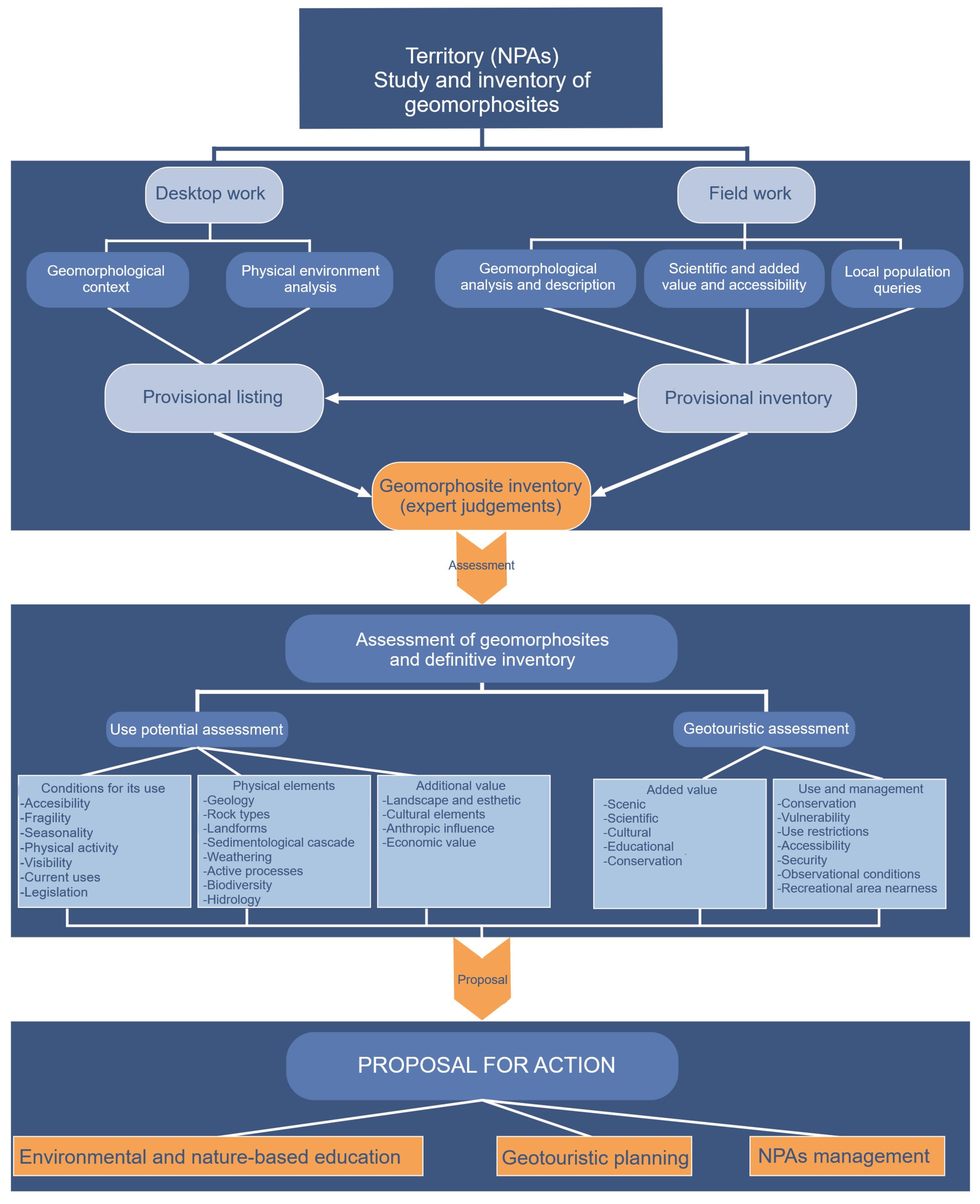
The term geoheritage is commonly used in academic and research work, often linked to geodiversity, landscapes, and conservation. Geoheritage can be defined as places or elements of the Earth with specific and recognized scientific value. Geosites are a key component of geoheritage, representing locations in the abiotic natural environment with recognized scientific value on site and of particular importance for understanding Earth’s evolution [1]. Geosites can be classified into various groups based on their scientific interest, such as structural, paleontological, hydrogeological, sedimentological, etc. When the geomorphological value is high, we can refer to them as geomorphosites, defined as portions of the geosphere of particular importance for understanding Earth’s history that are spatially delimited and clearly distinct from their surroundings [2,3,4].
These geomorphosites are often located within Natural Protected Areas (NPAs). Since the establishment of the first NPA in the world, Yosemite Valley in California, in 1864, the idea of preserving or conserving nature in delimited territories has been present. The concept of a common heritage that should be passed down to future generations is inherent in this idea. NPAs are created with the purpose of protecting outstanding spaces and creating common areas for the enjoyment of nature, its beauty, and its esthetics. The first NPAs have been established worldwide, including in Spain. When NPAs are declared anywhere in the world, a specific and strictly delimited natural heritage is established, despite the potential errors in artificially delimiting nature. However, the benefits include a natural, universal, and intergenerational common good. The management of NPAs immediately involves seeking a balance between use and conservation, considering both strictly natural values and anthropic or cultural values, and incorporating abiotic aspects as more than just support for natural beauty. In NPAs, geomorphological elements have a territorial and landscape component, gaining interest and value within the context of NPAs for their cultural significance and attracting travelers, hikers, or tourists seeking to understand the territory they are visiting. In this context, geomorphological heritage is a natural resource that can be used in local and regional development, especially as a territorial resource for educational, cultural, or touristic purposes [5,6]. Local societies are also drawn to landforms that have been part of their lives, familiar but not fully recognized for how they have shaped their understanding of their environment and their cultural relationship with them. NPAs embody the essence of their landscape in their relief and landforms, influencing the ecosystems or habitats present and the organization of the territory [7].
The concept of geotourism is relatively new but has experienced significant growth in the last decade [8,9,10,11,12]. Its origins can be traced back to the early 1990s with rural and nature tourism. The Arouca Declaration defines geotourism as “tourism that sustains and enhances the identity of a territory, taking into account its geology, environment, culture, aesthetic values, heritage, and the well-being of its residents”. Geotourism is recognized as a valuable tool for promoting natural and cultural heritage and fostering local and regional economic development, particularly in rural areas [5,13,14].
Since the beginning, emphasis has been placed on education and interpretation as important tools that can increase the awareness of geoheritage and conservation and contribute to the sustainable development of geotourism [15]. NPAs can be ideal locations for implementing geotourism initiatives, with many already having initiatives such as georoute design. NPAs offer opportunities for exploration and continuous learning in the field [16]. Geomorphosites are part of the tourism system due to their high esthetic and landscape value, as well as their historical and cultural significance, attracting tourists worldwide [7]. Developing geotourism in NPAs could help reduce overcrowding in popular tourist destinations, leading people to discover other nearby equally interesting but lesser-known areas [17,18].
The development of geotourism provides local residents with a means of income generation, employment, and skills development [19]. Therefore, it can be seen as a way to conserve and manage natural heritage, largely through the efforts of the local population and other stakeholders, who also benefit from the generation of income, employment opportunities, and, as mentioned earlier, the fact that tourism can be a powerful tool for local development in depressed rural areas.
In this study, the aim was to determine if the geomorphological heritage of the Sierras de la Paramera and la Serrota can be utilized as a geotourism resource, thus promoting local development in a mountain area with significant depopulation and the abandonment of traditional uses. The objectives of this work were (1) the study of geomorphological heritage and an inventory of geomorphosites, (2) the design and application of a method for evaluating geotourism potential, (3) and the creation of proposals for action.

2. Methodology

The methodology of this study was based on an inventory of geomorphosites, the assessment of their potential use, and the evaluation of their geotouristic potential (Figure 1). It consisted of three steps: desktop work, field work, and the overall evaluation of geomorphosites for geotourism [20].
1. The geomorphological study and inventory of geomorphosites was based on desktop work, which included geomorphological analysis and the analysis of the physical environment through the consultation of maps (a topographic map and orthophotomaps made by the National Geographic Spanish Institute), previous studies (existing geomorphological sketches from the National Geologic Institute), and photointerpretation (remote sensing data interpretation including digital elevation, hill shade, and slope models derived from LiDAR terrain models, digital orthophotomaps, and Google Earth imagery). This work enabled the development of a list of potential geomorphosites.
2. Fieldwork: We performed a detailed on-site analysis of each geomorphosite, describing and studying its scientific, esthetic, and accessibility value. The geomorphosite was classified according to whether it was an element (an isolated landform) or a site (a set of landforms with the same geomorphological genesis) and whether it was representative of its geomorphological context (there was more than one similar example) or exceptional (it was the only example of a particular landform). Consultation with the local population was also conducted to complete and develop the inventory of potential geomorphosites [7,20].
3. Geomorphosite assessment: The previously identified geomorphosites were numerically evaluated, giving them values from 0 to 4. The evaluation consisted of an expert judgment based on three steps, as shown in Figure 1:
a. Potential for use: Geomorphosites identified in the field were numerically evaluated. The evaluation was based on an expert judgment considering conditions for their use, their physical elements, and their additional value (Table 1). The analysis of the conditions for their use included the consideration of their accessibility, vulnerability to visitor influx, seasonality, the intensity of physical activity required to access the site, visibility, current uses, and legislation.
The evaluation of their physical elements included the consideration of their geological richness, landforms, inherited and active geomorphological processes, biodiversity, and an assessment of the hydrology of the geomorphosite.
The assessment of the additional value considered the landscape, existing cultural elements, anthropogenic influence, and economic value of the site.
b. The geotourism assessment focused on the managers and users of geomorphosites, aiming to consider elements regarding enjoyment, leisure, learning about the geomorphology and landscape, and territorial management. Therefore, more weight was given to the added value and use and management value than the intrinsic value [21]. Previous publications [7,20] have established a detailed assessment of criteria considered by other authors [8,21,22] and have combined them to obtain a comprehensive view of the natural, cultural, and added value of geomorphosites [7,20,23] (Table 2).

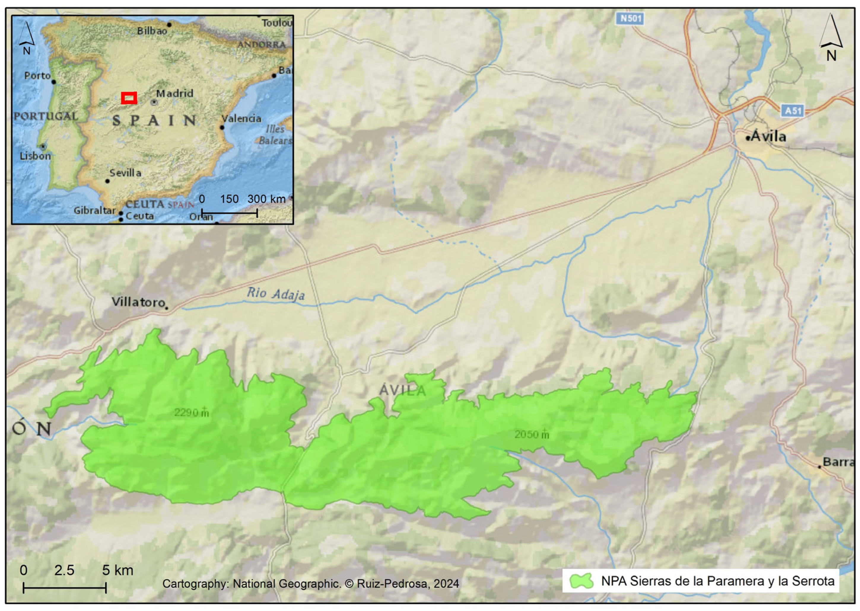
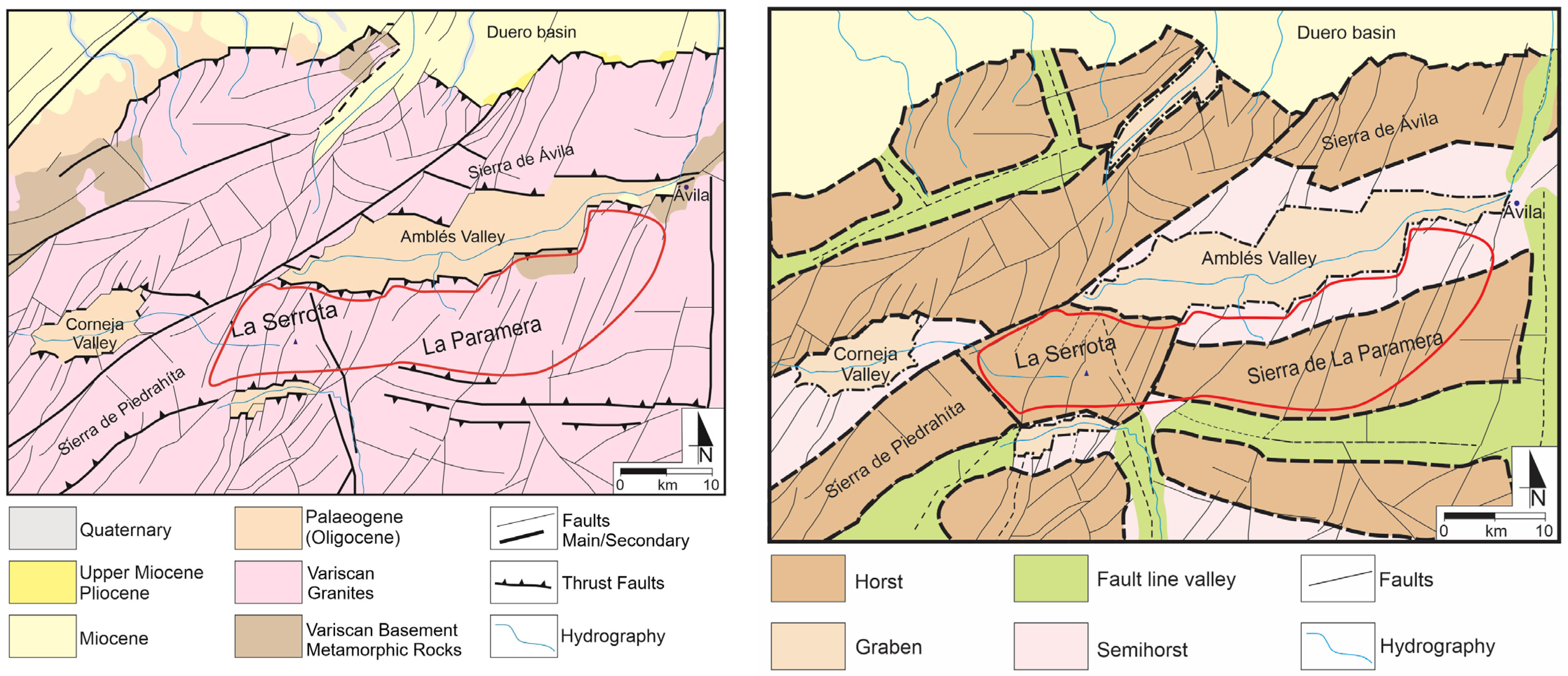
3. Study Zone: Sierras de la Paramera y Serrota

The Paramera and Serrota mountain ranges are located southwest of the city of Ávila (Figure 2) and serve as the watershed between the Duero and Tajo river basins. To the north, they border the Amblés Valley, with the Adaja River as its main watercourse, belonging to the Duero basin. To the south, they border the Alberche River, belonging to the Tajo basin. The altitudes in the study area ranged from 850 m at the bottom of the valleys to 2294 m, the highest point in La Serrota.
The study area was located in the western sector of the Central System and was part of the Gredos Complex, one of the three major structural complexes of the Central System [24,25,26]. Both mountain ranges belong to the Central Iberian Zone of the Hesperian Massif and are composed of Paleozoic granites and metasediments. In the late Mesozoic, an erosion surface was formed on which an alteration profile developed [27]. During the Alpine orogeny, especially in the Castellana and Neocastellana phases, tectonic blocks were fractured with pop-up and pop-down geological structures [26], leading to the formation of landforms (Figure 3).
The Paramera and Serrota mountain ranges exhibit a faulted relief, with both ranges forming horsts that stand out above the Amblés graben to the north and the Alberche graben to the south. Landforms are influenced by the type of granite, fracture patterns, climatic conditions, and their location in relation to the topography [28,29]. Various classifications of granite landforms exist based on their genesis, location, or size [28,30,31,32,33]. Examples of both major and minor granite forms can be found in the Paramera and Serrota mountain ranges [34] (Figure 4).
Glacial modeling characterizes the summit areas of La Serrota, and its general features are well known [35,36]. The interpretation of glaciation in La Serrota has varied, from a domed ice cap with outlets to valleys to the presence of cirque glaciers adapted to the topoclimatic conditions that generated cirque glaciers, overdeepened basins, and moraines in three recent Pleistocene periods. There are five cirque glaciers that define a cirque glacier morphology, Cerradillas, La Honda, Medialuna, Belesar, and Hornillos, which represent the only geomorphosite of glacial attribution.
The general layout of the erosion surface, the faulted relief with a succession of horsts, semihorsts, and grabens, the granite outcrops, and the landforms shaped by Quaternary glaciers characterize the geomorphology of this area and are its main tourist and educational attractions.

4. Results

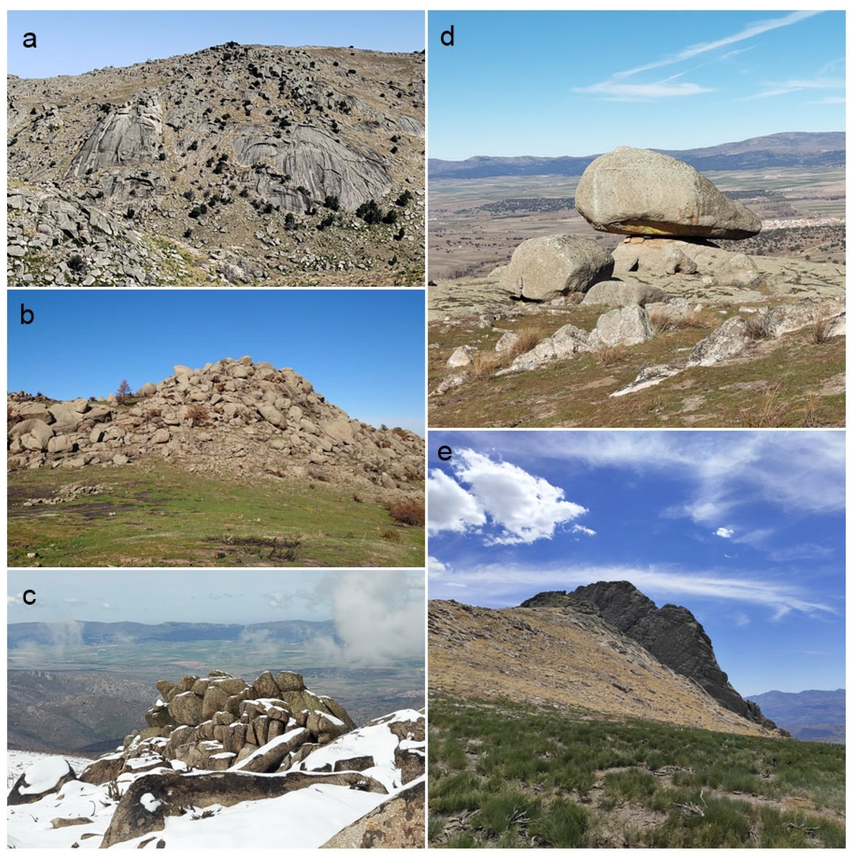
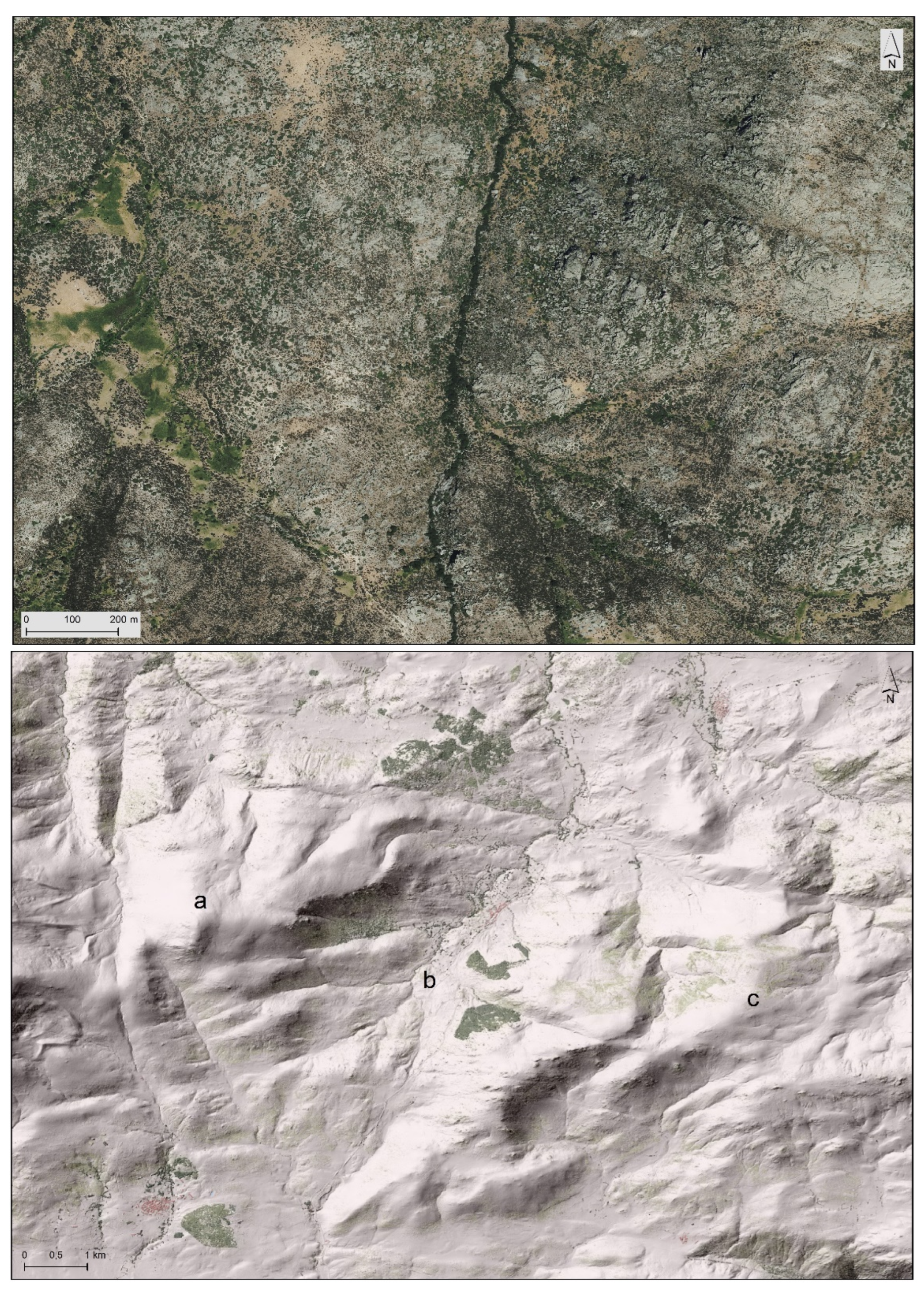
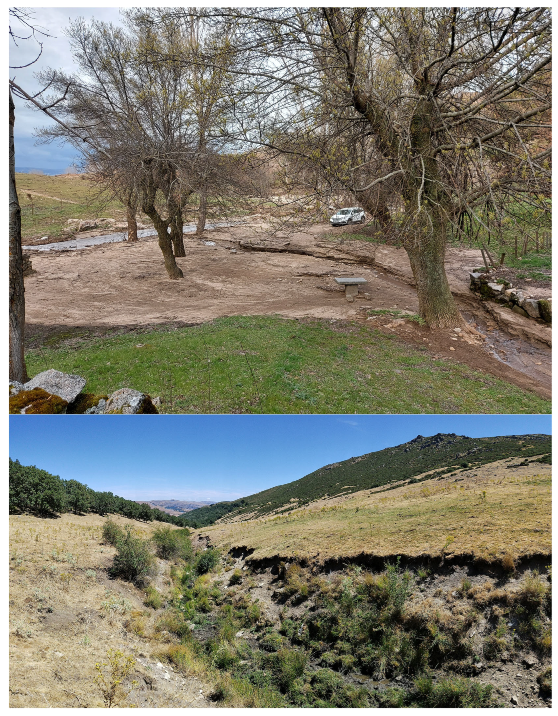
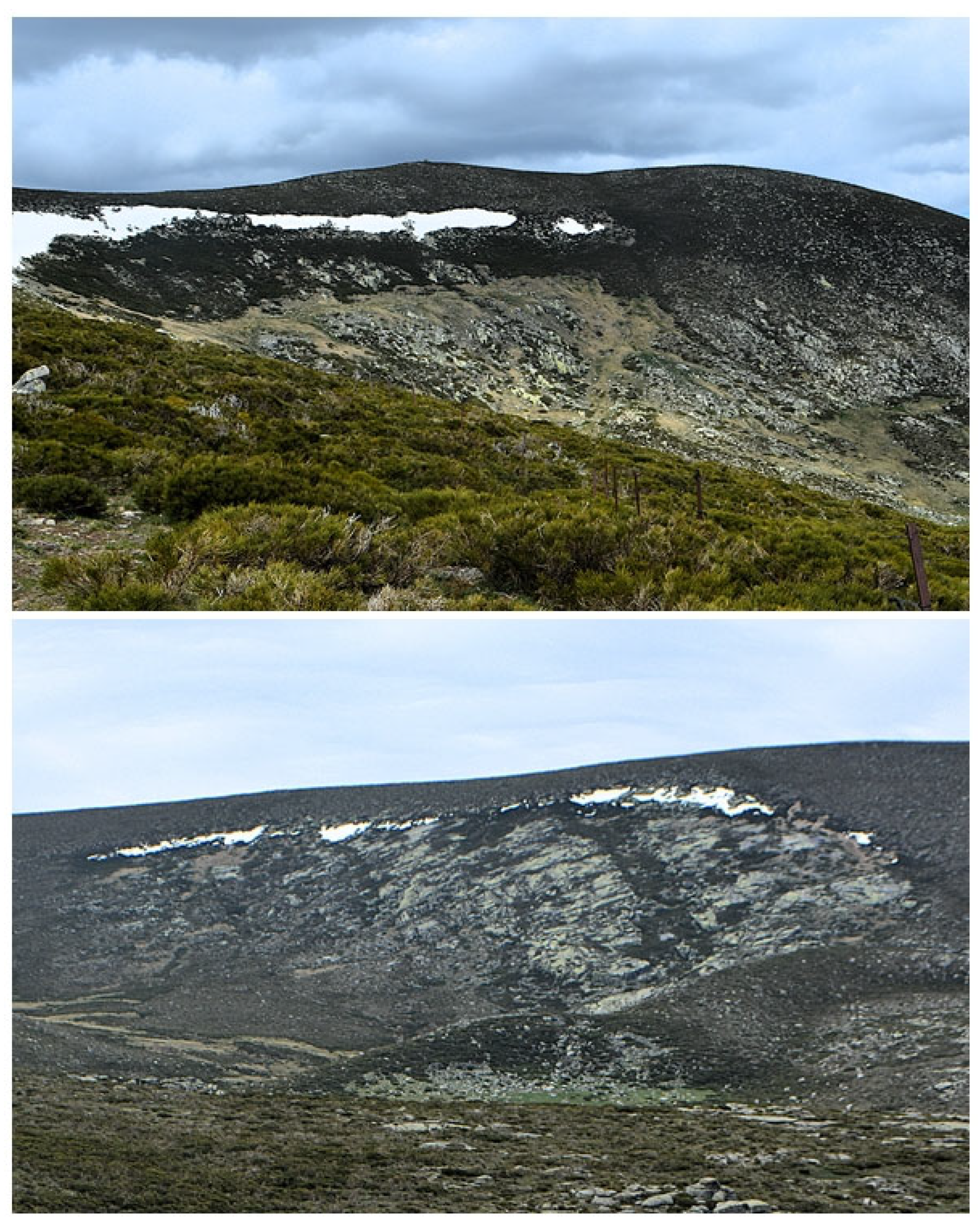
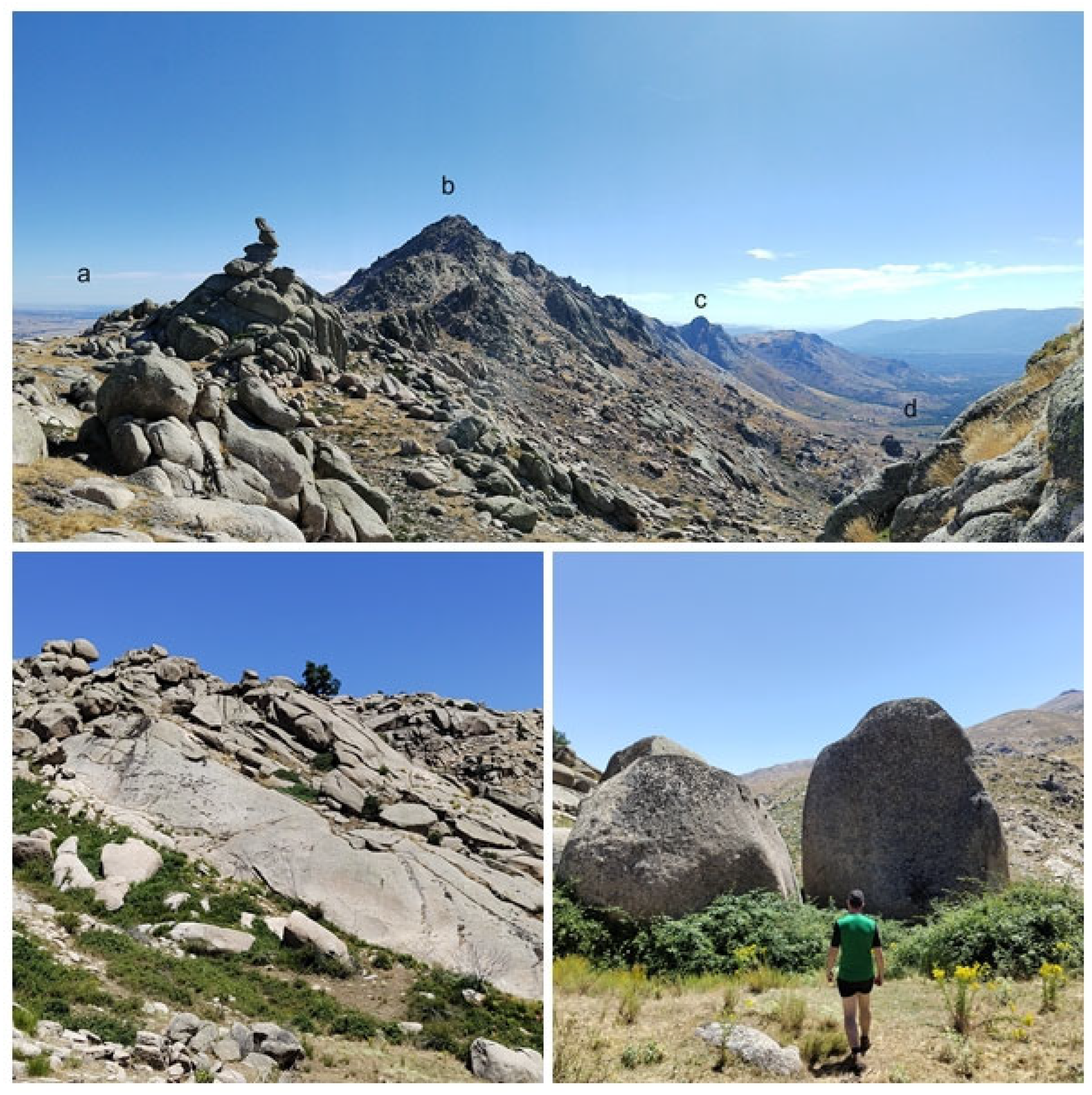
4.1. Geomorphosite Inventory

The 12 geomorphosites inventoried in the Sierras de la Paramera and Serrota reflected their faulted relief and granite and glacial shaping (Table 3).
The geomorphosite distribution was not homogeneous with respect to the Natura 2000 Network zone, with five of them located outside of it (Figure 5). These sites were selected based on their geoheritage value, as the delimitation of the Red Natura 2000 is based on biogeographical criteria and does not consider abiotic heritage. It is worth noting the concentration of geomorphosites in the surroundings of the Ulaca semihorst and the Picuezo river valley, where granite modeling and river incision create the most spectacular landscapes.
With a total of twelve geomorphosites, two of them were of structural attribution, two were fluvial, one was fluvial–granite, one was glacial, and the rest were granites.
The two structural geomorphosites (Nºs 9 and 11, the Garganta Honda fault line valley and Puerto de Mengamuñoz fault, Figure 6) reflect the morphostructure of the study area, conditioned by the faulted relief. Garganta Honda is a straight valley through which the Canto Moreno stream flows, with a V-shape following a north–south fracture. It acted as proglacial drainage for the Media Luna and La Honda glaciers, and granite outcrops can be seen on the slopes. The Mengamuñoz fault is a linear depression between the two mountain ranges formed by a straight regional fault line running north–south that separates two uneven tectonic blocks and facilitates the existence of the mountain pass. On one side is the Paramera horst to the east, more extensive but not exceeding 2000 m in altitude, and on the other side is the Serrota horst to the west, with a peak altitude of 2292 m, higher than La Paramera.
The fluvial geomorphosites (Nº 3 and Nº 8, the Picuezo river alluvial fan and Adaja river spring, Figure 7) represented the two main watercourses in the study area and their current dynamics. The alluvial fan of the Picuezo river is an excellent example of active fluvial transport and sedimentation, recently formed after the Navalacuz fire by the accumulation of sandstones and ashes. The high erosive force has caused damage to the recreational area. On the other hand, the Adaja river spring originates in a valley along a SW-NE fault line on the northern slope of La Serrota, emerging between porphyritic granites and flowing towards the Amblés Valley, forming a V-shaped valley. The importance of this geomorphosite lies in the significance of the Adaja river itself in the study area, which shapes the entire Amblés Valley.
The only fluvial–granite geomorphosite was number 12, the Picuezo river giant’s kettle (Figure 8). These concavities were formed in porphyritic granite in the riverbed of the Picuezo river in the La Hoya area. Formed on a gentle slope, they have a corridor-like appearance due to erosion caused by the Picuezo during periods of high water flow, carrying quartzite pebbles and forming spherical pools. They have great landscape value, offering views of the Picuezo valley and surrounding geomorphosites.
Geomorphosite Nº 7, the Serrota glacial cirques (Figure 9), was the only representation of glaciation in the study area, making it an exceptional and highly interesting location. These are three intensely degraded Pleistocene glacial cirques located on the eastern slope of La Serrota, the Media Luna Glacier, La Honda Glacier, and Las Serradillas Glacier, with the latter two being the largest. The cirques and frontal and lateral moraines are clearly visible from the southeast, although they are small in size and have been heavily eroded by the hydrological network.
The remaining geomorphosites of granite attribution represented various landforms of major and minor granite modeling (Figure 10), with the following being of high interest: Nº 1, the Ulaca semihorst; Nº 6, the Picos Zapateros granite mountain ranges; and Nº 10, the Gavilanes and Chinitas granite system. At geomorphosite Nº 1, the semihorst of Ulaca, outstanding examples of granite modeling could be observed, with characteristic forms such as boulder fields, nubbins, tors, domes, half domes, and pedestal rocks, as well as small forms like gnammas, tafonis, and a polygonal pattern of cracks. The abandoned village of Ulaca, a Cultural Interest Site since 1986, is of great relevance, hosting one of the most important Vettonian hillforts in Spain from a time period in which granite forms were available according to their location, influencing the Vettonian people’s uses and exploitation methods for them in the Iron Age. Geomorphosite Nº 6, the Picos Zapateros granite mountain ranges, is an iconic image of the Sierra de la Paramera, visible and recognizable from several kilometers away. These irregular pyramidal forms are the result of frost weathering in the vertical joints of the granite. They are an excellent example of granite weathering and erosion, with high landscape value, offering views of the city of Ávila, the Amblés Valley, and the Alberche Valley on a clear day. Lastly, the Gavilanes and Chinitas granite system (Nº 10) was one of the most spectacular granite landscapes in the study area. It consists of highly degraded and exhumed peaks due to granite weathering processes, resulting in a variety of visible and recognizable granite forms, both large and small. Particularly noteworthy are the two locations that give the geomorphosite its name: the Gavilanes peaks, two sharp-edged granite ridges, and the Chinitas blocks, two huge, isolated granite blocks.
There were three exceptional geomorphosites: geomorphosite Nº 4, a granite rock with thermal weathering as a result of the large forest fire in Navalacruz in 2022; Nº 7, the Serrota glacial cirques, being the only area in the NPA where we found glaciation; and Nº 12, the Picuezo river giant’s kettle, as this riverbed is where the most spectacular kettles were formed. Out of twelve geomorphosites, only two had high accessibility—Nº 8, the Adaja river spring, and Nº 11, the Puerto de Mengamuñoz fault—the first one being less than 3 km from a parking spot and the Mengamuñoz mountain pass fault being accessible by car via the N-502 road. At the rest, a medium level of accessibility was characterized by the absence of marked trails, as there were hardly any signposted geotourism routes. Additionally, the paths were rocky, more than 3 km long, and had relatively steep slopes. In terms of interest, eight geomorphosites were of high interest, and four were of medium interest. The latter were characterized by greater geomorphological specialization and lower landscape and cultural value.

4.2. Geomorphosite Use Potential and Geotourism Assessment

After applying the described methodology, the results were obtained for each geomorphosite and each of the three groups. A summary and comparison can be seen in Table 4.
All inventoried geomorphosites in the study area had a medium global value, with lower values in their additional value and higher values in the conditions for their use (Table 2, Column A). The higher values corresponded to the geomorphosites located within the Red Natura area, as they had medium environmental protection and most had a very high visibility value. Accessibility was a negative factor, as in most geomorphosites the paths were rocky, unmarked, and not signposted, with moderate physical activity levels required for some of them, marked slopes, and long distances. The geomorphosites with the highest value in this regard were Nº 8, the Adaja river spring, and Nº 11, the Puerto de Mengamuñoz fault, characterized by high accessibility as both had current uses, the former for hiking and livestock and the latter as a mountain pass. Geomorphosites Nº 2, 5, 7, and 10 had a high value (the Manqueospese granite castle, Responsos isolated granite rock, Serrota glacial cirques, and Gavilanes and Chinitas granite system), all with low fragility and medium accessibility. All geomorphosites except the Serrota glacial cirques, where snow prevents visits in winter, were visitable all year round. Regarding the geomorphological value (Table 2, Column B), all geomorphosites had a medium value, except Nºs 9 and 11, of structural attribution, due to their specialization. On the contrary, the highest score was for geomorphosite Nº 12, the Picuezo river giant’s kettle, as it presented various landforms and was an excellent example of weathering, erosion, transportation, and sedimentation, as well as an active process, and the Picuezo river was a great hydrological example. Following closely were four geomorphosites, Nºs 1, 2, 4, and 10, all of granite attribution and which, despite the spectacularity of their landforms, did not have hydrological examples or active process examples. A common feature of all twelve geomorphosites was the scarcity of biodiversity, as the area was affected by a forest fire in 2022 and it was difficult to visualize any fauna species.
Finally, in the Paramera and Serrota areas, the additional value was high at two geomorphosites—Nºs 1 and 2—low at three geomorphosites—Nºs 4, 9, and 12—and medium at the rest (Table 2, Column C). Except for those geomorphosites with livestock use, none had economic value. The same applied to cultural elements, with high value only at the Ulaca semihorst and Manqueospese granite castle. The landscape value was generally medium or high, and the human influence was high at those geomorphosites with cultural elements and present economic activity.
The geotouristic assessment (Table 5) showed that only one of the geomorphosites had high potential and the potential of more than half was low.
At the Paramera and Serrota geomorphosites, the worst values for geotouristic potential were found in the additional value, which included accessibility, safety, observation conditions, and the proximity to recreational areas. While observation conditions were good at all geomorphosites, which, as has already been mentioned, were easily recognizable in the field, the scores for accessibility and safety were average, due to the lack of marked and tourist-friendly trails and paths. Additionally, in the study area, there was only one recreational area, the Molino del Quemado at the Picuezo river alluvial fan, although it was destroyed by river floods after the fire. Not even the most visited site, which was the Ulaca semihorst, with relative importance to local tourism, had a visitor center or a recreational area. Nevertheless, Ulaca achieved the highest score, being the only geomorphosite in Paramera–Serrota with high tourist potential as it had the maximum scenic, scientific, and cultural value. The educational value was low at most geomorphosites, understood here as the interpretative potential and the existence of excursions, educational resources, or guided tours, with no examples in Paramera and Serrota. The lowest tourist potential values were for those geomorphosites without cultural or interpretative elements where the scenic and/or scientific value was medium, as at geomorphosites Nº 4, 5, and 9. At geomorphosites with a medium value, such as the Serrota glacial cirques, Gavilanes and Chinitas, and the Adaja river spring, an improvement in their additional value would be sufficient to increase their tourist potential to high.

5. Discussion

The results of the assessment of both the intrinsic and tourism potential of the geomorphosites provide information on the most appropriate actions in each location. In the Sierras de la Paramera and la Serrota, with no tourist infrastructure, a lack of educational resources (such as panels or information centers), and no recreational areas, it does not seem sensible to propose geotourism initiatives. This area requires a valorization of its heritage originating from the local population, a process that appears to be gaining momentum, especially after the fire.
Therefore, the first actions to be performed should focus on dissemination and environmental education. The limited teaching of Geography and Earth Sciences hinders the appreciation of geomorphological heritage by the population, and some authors have pointed out the need to involve young people in geoconservation [37]. According to Prosser [38], most people do not understand Geosciences, geoheritage, or Geography, and therefore it is necessary to connect communities with Natural Protected Areas and geoheritage. This is especially important in areas with declining demographics, very low population densities, and the abandonment of rural uses. Thus, supporting environmental education and geotourism activities in NPAs requires close communication with local communities and initiatives to develop the effective management of geotouristic resources incorporating geomorphosites. The involvement of the local population, in addition to promoting local development, improves the acceptance of conservation measures [39,40,41,42].
In the Paramera and Serrota mountain ranges, dissemination activities are particularly useful, as demonstrated in the case of the Ulaca site [43]. Before proposing any geotourism initiative, it is essential for residents of NPAs to know, understand, and value the abiotic natural heritage that surrounds them and to be included in the management and research processes carried out in these areas. This participation is beneficial not only for the local population, fostering their connection with the natural heritage and therefore affecting their perception of heritage and desire for conservation, but also for researchers themselves, as the local population can actively contribute their knowledge and experience. It is necessary for local residents, who are currently partially disconnected from the natural environment, traditional uses, and land management due to the depopulation of the mountains, to have knowledge of the natural value and outstanding characteristics that allow them to value the territory as a collective asset. The high participation in the dissemination activity carried out in Ulaca, despite being promoted only among the local population of the NPA and near the provincial capital, and its geomorphological focus demonstrates a significant interest in Geography, natural heritage, and geographical features, contrary to what might be expected. This was also expressed by participants in their final comments, which mentioned appreciating the geographical and geomorphological approach to a space where historical and archeological explanations prevail [43].
In Paramera and Serrota, geomorphosites’ geotouristic potential was found to be low. However, this poor assessment was not due to a lack of intrinsic interest in the geomorphosites, which had medium to high scenic, scientific, and conservation value, but rather to the underdevelopment of their additional value, which can easily be improved. Investing in improving accessibility, creating recreational areas, and creating interpretive products would be enough to increase this added value and raise their geotouristic potential to high. Geomorphosites’ potential largely depends on accessibility, infrastructure, and protection.
Therefore, here is a proposal to promote geotourism in the Paramera–Serrota region, which could be successful based on the following reasons: 1. existing tourist infrastructure capable of accommodating rural tourists, 2. a target audience already staying in rural accommodation, with the province of Ávila leading in regard to tourism in the region, 3. a tradition of hiking in the Serrota area, 4. The proximity to the city of Ávila (20 km) and Madrid (140 km, a major source of rural tourists in Ávila), 5. recent interest from the Ávila County Council in developing routes in the Paramera–Serrota region, indicating potential support from this administration.
This commitment to a geotourism promotion plan would enhance the appreciation of natural heritage and geomorphosites as an important territorial resource for the region, which not only offers cultural services for the local population and visitors but also helps to revitalize the area. All of this would benefit the local population, who could access jobs related to the geotourism sector (nature interpreters, transportation, services, etc.), and therefore contribute to the economic development of the region and population retention, a significant issue in this study area. Such local and regional development in deprived rural areas based on geotourism has already been advocated for by numerous authors performing case studies in Geoparks and Natural Protected Areas around the world in recent years [11,13,44,45,46].
Not only would the development of geotourism in the area benefit local development, but geotourism itself is a type of sustainable nature tourism that arises from the evolution and combination of ecotourism and sustainable tourism, ensuring the preservation of natural heritage, as is argued by numerous authors [5,9,11,15,40,47,48,49,50]. Geotourism aims to promote tourism development opportunities while ensuring the conservation and protection of geoheritage attributes, so it can be an opportunity to provide protection in study areas such as Paramera and Serrota, where heritage does not enjoy truly effective preservation. Therefore, once again, the involvement of local residents in geotourism planning is crucial for the sustainability of the process, ensuring that stakeholders have acceptance of and find empowerment in the development of geotourism. Appropriate eco-ethics regarding the participation of residents and tourists in the planning process includes developers taking into account the attitudes and feelings of the local community, including how an untouched local environment contributes to a sense of community belonging [11]. Any geotourism development should not diminish the enjoyment of the environment by the local community and, whenever possible, should enhance it. Therefore, regional geotourism development should be carried out within the context of sustainable local, national, and international tourism development.

6. Conclusions

Sites of geomorphological heritage, specifically geomorphosites, are places with great geotouristic potential due to their scientific and cultural interest, as well as their connections to the local territory and the development of the local population. Geomorphosites may not have high scientific value at an international, national, or regional scale, but they hold local value due to their relationship with the territory, environmental and cultural heritage, and their connection to the populations that inhabit them.
This potential is hindered by a lack of environmental education and the limited recognition of geotourism, with a lack of proper integration and planning for the use of these sites in Spain and specifically in the study region. Utilizing and planning the development of geomorphosites with a geotouristic focus in NPAs can diversify visits, alleviate congestion in popular areas, and connect them to other natural environments (habitats, forests, geosites, or landscapes) through proposed uses and visitable sites linked to geomorphosites. Additionally, a geotouristic use of geomorphosites can expand the range of recreational, educational, or geotouristic activities in two ways: (a) as a tool for diversifying the visited locations and (b) as tools for local development in the surrounding areas by attracting populations and generating new territorial dynamics, always with the involvement of local communities in various tasks.
The designed methodology allowed for the inventory of geomorphosites in a mountain area where no such work had been performed previously, as well as a geotouristic assessment of these sites. This assessment identified the weaknesses in the geotouristic infrastructure of the study area, where despite having medium to high scientific and cultural value, the tourist infrastructure is underdeveloped. As a result, the geotouristic potential of the geomorphosites was low in most cases, and geotouristic initiatives have not been implemented. Therefore, the methodology presented is useful for analyzing geotouristic potential not only in medium-sized NPAs but in any natural area where there is an inventory of geomorphosites, at any scale.
The Paramera and Serrota mountain ranges lack interpretive materials and geotouristic infrastructure, with medium accessibility to most geomorphosites. The 12 geomorphosites inventoried represent the structural relief and spectacular granite modeling that characterizes them, as well as the glacial traces present in La Serrota. Strategies have focused on providing environmental education among residents but in the future should focus on dissemination, public investment, and effective collaboration among researchers, private entities, public administrations, and local residents, which will undoubtedly increase the tourist potential of the area and allow for the design of a local development strategy based on the exploitation of its geomorphological heritage through geotourism.

Author Contributions

Conceptualization, R.M.R.-P. and E.S.; methodology, R.M.R.-P. and E.S.; investigation, R.M.R.-P. and E.S.; writing—original draft, R.M.R.-P.; writing—review and editing, R.M.R.-P. and E.S. All authors have read and agreed to the published version of the manuscript.

Funding

This research was funded by the Pangea Research Group (Natural Heritage and Applied Geography Research Group, University of Valladolid). R.M.R.-P. holds a Pre-Doctoral fellowship funded by the University of Valladolid.

Data Availability Statement

The original contributions presented in the study are included in the article, further inquiries can be directed to the corresponding author.

Conflicts of Interest

The authors declare no conflicts of interest.

Abbreviations

The following abbreviations are used in this manuscript:
NPAsNatural Protected Areas

References

  1. Reynard, E.; Coratza, P. Scientific research on geomorphosites. A review of the activities of the IAG working group on geomorphosites over the last twelve years. Geogr. Fis. Din. Quaternaria 2013, 36, 159–168. [Google Scholar] [CrossRef]
  2. Panizza, M. Geomorphosites: Concepts, methods and example of geomorphological survey. Chin. Sci. Bull. 2001, 46, 4–6. [Google Scholar] [CrossRef]
  3. Reynard, E.; Panizza, M. Geomorphosites: Definition, assessment and mapping. Géomorphosites 2005, 11, 177–180. [Google Scholar] [CrossRef]
  4. Reynard, E. Geomorphosites: Definitions and characteristics. In Geomorphosites; Reynard, E., Coratza, P., Regolini-Bissig, G., Eds.; Verlag Dr. Friedrich Pfeil: Munich, Germany, 2009; pp. 9–20. [Google Scholar]
  5. Newsome, D.; Dowling, R. Geoheritage and Geotourism. In Geoheritage; Elsevier: Amsterdam, The Netherlands, 2018. [Google Scholar] [CrossRef]
  6. Coratza, P.; Reynard, E.; Zwoliński, Z. Geodiversity and Geoheritage: Crossing Disciplines and Approaches. Geoheritage 2018, 10, 525–526. [Google Scholar] [CrossRef]
  7. Serrano, E.; González Amuchastegui, M.J.; Ruiz Pedrosa, R.M. Patrimonio natural y geomorfología. In Los Lugares de Interés Geomorfológico del Parque Natural del Cañón del Río Lobos; Ediciones Universidad de Valladolid: Valladolid, Spain, 2020. [Google Scholar]
  8. Kubalíková, L. Geomorphosite assessment for geotourism purposes. Czech J. Tour. 2014, 2, 80–104. [Google Scholar]
  9. Gordon, J.E. Rediscovering a Sense of Wonder: Geoheritage, Geotourism and Cultural Landscape Experiences. Geoheritage 2012, 4, 65–77. [Google Scholar] [CrossRef]
  10. Newsome, D. Geotourism; Routledge: London, UK, 2006. [Google Scholar]
  11. Ólafsdóttir, R.; Dowling, R. Geotourism and Geoparks-A Tool for Geoconservation and Rural Development in Vulnerable Environments: A Case Study from Iceland. Geoheritage 2014, 6, 71–87. [Google Scholar] [CrossRef]
  12. Dóniz-Páez, F.J.; Becerra-Ramírez, R.; García-Romero, L.; Hernández Ramos, W. Itinerario geoturístico en el Valle de El Golfo como ejemplo de desarrollo territorial en el Geoparque Mundial Unesco de El Hierro, España. XXV Coloq. Hist. Canar.-Americana 2022, 25, XXV-048. [Google Scholar]
  13. Kubalíková, L. Assessing geotourism resources on a local level: A case study from Southern Moravia (Czech Republic). Resources 2019, 8, 150. [Google Scholar] [CrossRef]
  14. Coratza, P.; Hobléa, F. The Specificities of Geomorphological Heritage. In Geoheritage; Reynard, E., Brilha, J., Eds.; Elsevier: Amsterdam, The Netherlands, 2018; Volume 5, pp. 87–106. [Google Scholar] [CrossRef]
  15. Kubalíková, L.; Drápela, E.; Bajer, A.; Zapletalová, D.; Balková, M.; Zágoršek, K.; Kirchner, K.; Kuda, F.; Roštínský, P. Geological paths—Their use for the regional geography teaching. In Proceedings of the 27th Central European Conference, Brno, Czech Republic, 17 October 2019; pp. 113–124. [Google Scholar] [CrossRef]
  16. Tormey, D. New approaches to communication and education through geoheritage. Int. J. Geoheritage Parks 2019, 7, 192–198. [Google Scholar] [CrossRef]
  17. Gray, M. Geodiversity: The backbone of geoheritage and geoconservation. In Geoheritage; Reynard, E., Brilha, J., Eds.; Elsevier: Amsterdam, The Netherlands, 2018; pp. 13–25. [Google Scholar] [CrossRef]
  18. Stojilković, B.; Gray, M. Geodiversification: The Evolution of Geodiversity Through Time. Geoheritage 2024, 16, 91. [Google Scholar] [CrossRef]
  19. Torabi Farsani, N.; Coelho, C.; Costa, C. Geotourism and Geoparks as Gateways to Socio-cultural Sustainability in Qeshm Rural Areas, Iran. Asia Pac. J. Tour. Res. 2012, 17, 30–48. [Google Scholar] [CrossRef]
  20. Ruiz-Pedrosa, R.M.; González-Amuchástegui, M.J.; Serrano, E. Geomorphosites as Geotouristic Resources: Assessment of Geomorphological Heritage for Local Development in the Río Lobos Natural Park. Land 2024, 13, 128. [Google Scholar] [CrossRef]
  21. Pralong, J.-P. A method for assessing tourist potential and use of geomorphological sites. Géomorphologie Relief Process. Environ. 2005, 11, 189–196. [Google Scholar] [CrossRef]
  22. Brilha, J. Inventory and Quantitative Assessment of Geosites and Geodiversity Sites: A Review. Geoheritage 2016, 8, 119–134. [Google Scholar] [CrossRef]
  23. Serrano, E.; González-Amuchastegui, M.J.; Ruiz-Pedrosa, R.M. Geomorphosites and geomorphological maps applied to public use, tourism and natural heritage management in the Rio Lobos Natural Park (Spain). Geomorphology 2025, 471, 109573. [Google Scholar] [CrossRef]
  24. Capote, R.; Diaz, M.; Gabaldon, V.; Gomez, J.J.; Sanchez de la Torre, L.; Ruiz, P.; Rosell, J.; Sopeña, A.; Yebenes, A. Evolución Sedimentológica y Tectónica del Ciclo Alpino en el Tercio Noroccidental de la Rama Castellana de la Cordillera Ibérica; Instituto Geológico y Minero de España: Madrid, Spain, 1982. [Google Scholar]
  25. De Vicente, G.; Vegas, R.; Muñoz-Martín, G.; Silva, P.G.; Andriessen, P.; Cloetingh, S.A.P.L.; González Casado, J.M.; Van Wees, J.D.; Álvarez, J.; Carbó, A.; et al. Cenozoic thick-skinned deformation and topography evolution of the Spanish Central System. Glob. Planet. Change 2007, 58, 335–381. [Google Scholar] [CrossRef]
  26. De Vicente, G.; Cunha, P.P.; Muñoz-Martín, A.; Cloetingh, S.A.P.L.; Olaiz, A.; Vegas, R. The Spanish-Portuguese Central System: An example of intense intraplatedeformation and strain partitioning. Tectonics 2018, 37, 4444–4469. [Google Scholar] [CrossRef]
  27. Fernández Ruiz, J.; Herreros Villanueva, V.; Lillo Ramos, J.; López Sopeña, F.; Olivé Davó, A. Memoria de la Hoja 555 de Navatalgordo. Mapa Geológico de España; IGME: Madrid, Spain, 2006. [Google Scholar]
  28. Sanz Herráiz, C. El Relieve del Guadarrama Oriental; Comunidad de Madrid, Consejería de Política Territorial: Madrid, Spain, 1988. [Google Scholar]
  29. Migoń, P.; Vieira, G. Granite geomorphology and its geological controls, Serra da Estrela, Portugal. Geomorphology 2014, 226, 1–14. [Google Scholar] [CrossRef]
  30. Twidale, C.R. Granite Landforms; Elsevier: Amsterdam, The Netherlands, 1982. [Google Scholar]
  31. Twidale, C.R.; Vidal-Romani, J.R. Landforms and Geology of Granite Terrains; CRP Press: Boca Raton, FL, USA, 2005. [Google Scholar]
  32. Migón, P. Granite Landscapes of the World; Oxford University Press: New York, NY, USA, 2006. [Google Scholar]
  33. Migoń, P. Granite Landscapes, Geodiversity and Geoheritage—Global Context. Heritage 2021, 4, 198–219. [Google Scholar] [CrossRef]
  34. Ruiz-Pedrosa, R.M.; Serrano, E. Granite Landscapes and Landforms in the Castro de Ulaca Site (Ávila, Spain): A Narrow Relationship between Natural and Cultural Heritage. Sustainability 2023, 15, 10470. [Google Scholar] [CrossRef]
  35. Hernández Pacheco, F.; Vidal Box, C. El Glaciarismo Cuaternario de La Serrota; Museo Nacional de Ciencias Naturales: Madrid, Spain, 1934. [Google Scholar]
  36. Arenillas, M.; Martinez de Pison, E. La morfologia glaciar de la Serrota (Avila). Bol. De La Real Soc. Geogr. Madr. 1976, 1, 21–26. [Google Scholar]
  37. Worton, G.J.; Gillard, R. Local communities and young people—The future of geoconservation. Proc. Geol. Assoc. 2013, 124, 681–690. [Google Scholar] [CrossRef]
  38. Prosser, C.D. Communities, Quarries and Geoheritage—Making the Connections. Geoheritage 2019, 11, 1277–1289. [Google Scholar] [CrossRef]
  39. Cocean, G.; Cocean, P. An Assessment of Gorges for Purposes of Identifying Geomorphosites of Geotourism Value in the Apuseni Mountains (Romania). Geoheritage 2017, 9, 71–81. [Google Scholar] [CrossRef]
  40. Bouzekraoui, H.; Barakat, A.; Touhami, F.; Mouaddine, A.; El Youssi, M. Inventory and assessment of geomorphosites for geotourism development: A case study of Aït Bou Oulli valley (Central High-Atlas, Morocco). Area 2018, 50, 331–343. [Google Scholar] [CrossRef]
  41. Bouzekraoui, H.; Barakat, A.; Mouaddine, A.; El Youssi, M.; Touhami, F.; Hafid, A. Mapping geoheritage for geotourism management, a case study of Aït Bou Oulli Valley in Central High-Atlas (Morocco). Environ. Earth Sci. 2018, 77, 413. [Google Scholar] [CrossRef]
  42. Pijet-Migoń, E. Promoting and Interpreting Geoheritage at the Local Level—Bottom-up Approach in the Land of Extinct Volcanoes, Sudetes, SW Poland. Geoheritage 2019, 11, 1227–1236. [Google Scholar] [CrossRef]
  43. Ruiz-Pedrosa, R.M.; Serrano, E. Dissemination and Interpretation of Natural Heritage in Sierra de la Paramera (Ávila, Spain). An Experimental Activity on Geomorphosites, Cultural Heritage and Landscape. Geoheritage 2024, 16, 86. [Google Scholar] [CrossRef]
  44. Deng, L.H.; Zou, F.H. Geotourism and geoparks for sustainable rural development and poverty alleviation: Huanggang Dabieshan UNESCO Global Geopark, China. Aust. J. Earth Sci. 2022, 69, 286–301. [Google Scholar] [CrossRef]
  45. Carrillo-Hernández, Y.M.; Ríos-Reyes, C.A.; Villarreal-Jaimes, C.A. Geotourism and geoeducation: A holistic approach for socioeconomic development in rural areas of Los Santos Municipality, Santander, Colombia. Geoheritage 2024, 16, 94. [Google Scholar] [CrossRef]
  46. Carrión-Mero, P.; Borja-Bernal, C.; Herrera-Franco, G.; Morante-Carballo, F.; Jaya-Montalvo, M.; Maldonado-Zamora, A.; Berrezueta, E. Geosites and geotourism in the local development of communities of the andes mountains. A Case Study. Sustain. 2021, 13, 4624. [Google Scholar]
  47. Dowling, R.K. Geotourism’s Global Growth. Geoheritage 2011, 3, 1–13. [Google Scholar] [CrossRef]
  48. Escriche, M.M. La función didáctica del geoturismo. Propuestas para la region de Murcia. The didactic function of geotourism. Proposals for the region of Murcia. Gran Tour 2011, 4, 62–93. [Google Scholar]
  49. Marino Alfonso, J.L.; Poblete Piedrabuena, M.Á.; Beato Bergua, S.; Herrera Arenas, D. Geotourism Itineraries and Augmented Reality in the Geomorphosites of the Arribes del Duero Natural Park (Zamora Sector, Spain). Geoheritage 2021, 13, 16. [Google Scholar] [CrossRef]
  50. Dóniz Páez, J.; Becerra-Ramírez, R.; Beltrán Yanes, E. Geomorfositios en el Geoparque Mundial Unesco de El Hierro (Islas Canarias, España) para fomentar el geoturismo en espacios volcánicos. Rev. Geogr. Norte Gd. 2021, 80, 165–186. [Google Scholar] [CrossRef]
Figure 1. Geomorphosite inventory and assessment methodology flow chart. Made by the authors.
Land 14 00982 g001
Figure 2. Location of the Sierras de la Paramera y Serrota, 20 km from the city of Ávila. Made by the authors.
Land 14 00982 g002
Figure 3. Geological (left) and geomorphological (right) maps of the Sierras de la Paramera and La Serrota, showing the materials and morphological structures that characterize the landforms. The study area is marked in red. Made by the authors.
Land 14 00982 g003
Figure 4. Outstanding granite landforms in the Sierras de la Paramera y la Serrota: (a) unexhumed vertical dome rock platforms on the northern slope of the Ulaca semihorst, (b) nubbins and boulder fields in Majadas Highs, (c) a tor in the Sierra de la Paramera (ascent to Zapatero; in the background, the Amblés Valley and the Sierra de Ávila), (d) a pedestal rock at Ulaca hillfort, (e) the Peña Cabrera granite ridge.
Land 14 00982 g004
Figure 5. Inventoried geomorphosites in the Sierras de la Paramera y la Serrota. Numbers correspond to the geomorphosites described in Table 1. Made by the authors.
Land 14 00982 g005
Figure 6. Structural geomorphosites. Above: Nº 9, Garganta Honda fault line valley. Below: Nº 11, Puerto de Mengamuñoz fault: (a) Serrota horst, (b) Mengamuñoz fault, (c) Paramera horst. Source: Google Earth.
Land 14 00982 g006
Figure 7. Fluvial geomorphosites. Above: Nº 3, Picuezo river alluvial fan. Below: Nº 8, Adaja river spring (all photos were by authors).
Land 14 00982 g007
Figure 8. Fluvial–granite geomorphosite. Nº 8, Picuezo river giant’s kettle (all photos were by authors).
Land 14 00982 g008
Figure 9. Glacial geomorphosite Nº 7, Serrota glacial cirques. Above: La Honda glacial cirque and nivation hollows. Below: Belesar glacial cirque and frontal moraines (all photos were by authors).
Land 14 00982 g009
Figure 10. Granite geomorphosite examples. Above: Nº 6, Picos Zapateros granite mountain ranges. Letters refer to (a) Zapatero saddle, (b) Zapatero peak, (c) Risco del Sol peak, and (d) Alberche Valley. Below: Nº 10, Gavilanes and Chinitas granite system. Left: Chinitas dome; right: Chinitas rocks (all photos were by authors).
Land 14 00982 g010
Table 1. Geomorphosite assessment method.
  • Conditions for its use
Accessibility0: no path; 2: loose rock path; 4: well-defined path
Fragility (risk of degradation)0: high (the geomorphosite is already degraded); 2: moderate (the geomorphosite is in the process of degradation); 4: low (no degradation)
Seasonality0: can be visited for less than 3 months per year; 2: can be visited for 3–6 months per year; 4: can be visited all year round
Intensity of physical activity (distance and slope)0: >15 km and +1.000 m; 2: <10 km and +500 m; 4: <5 km and <500 m
Visibility of the geomorphosite0: no visibility; 2: medium visibility; 4: full visibility
Current uses0: there are none; 2: occasional use; 4: frequent use
Legislation0: there is none; 2: in development; 4: strong protection
TOTAL (up to 28)
2.
Physical elements
Geology0: one geological era; 2: two geological eras; 4: three or more geological eras
Rock types (igneous, sedimentary, and metamorphic)0: there are none; 2: up to four; 4: five or more
Superficial landforms0: there are none; 2: one or two; 4: three or more
Sedimentological cascade 0: no evidence; 2: one example; 4: two or more examples
Weathering (chemical, physical, or biological)0: no evidence; 2: one example; 4: two or more examples
Active processes0: no active processes; 2: one example; 4: two or more examples
Biodiversity0: no evidence; 2: one example; 4: two or more examples
Hydrology0: no liquid or solid water; 2: one example; 4: two or more examples
TOTAL (up to 32)
3.
Additional value
Landscape and esthetic0: no view of landscape, landscape entirely covered by natural or anthropogenic features; 2: view of landscape obstructed, e.g., by vegetation or other elements of natural environment; 4: wide view of landscape, no obstacles to observation
Cultural elements0: no existence; 2: one example; 4: more than one example
Anthropic influence0: dominance of nature, space little or not at all modified by humans; 2: rural/natural space partially modified by man; 4: anthropogenic influence dominates over natural influence
Economic value0: no economic activities; 2: one economic activity; 4: more than two economic activities
TOTAL (up to 16)
Table 2. Tourism potential assessment and assigned values.
CriteriaImportanceProposed Numerical Assessment Values
Scenic: panoramic view, extent of panoramic view, geographic diversity, natural diversity150–5–10–15
Scientific: integrity, rarity, geodiversity, scientific knowledge100–5–10
Cultural: presence of cultural value, value of cultural elements, number of elements, historical diversity150–5–10–15
Educational: representativeness and clarity of forms or processes, pedagogical exemplarity, didactic documentation available, current educational use50–5
ConservationVulnerability: risk of degradation and fragility100–5–10
Limitations on use: legislation for its protection50–5
Additional values 100–5–10
Accessibility100–5–10
Security150–5–10–15
Observation conditions50–5
Total (up to 100)
Table 3. Geomorphosites in Sierras de la Paramera y la Serrota.
Geomorphological AttributionType *AccessibilityInterest
1GranitePlaceRepresentativeMediumHigh
2GranitePlaceRepresentativeMediumHigh
3FluvialPlaceRepresentativeMediumHigh
4GraniteElementExceptionalMediumMedium
5GraniteElementRepresentativeMediumMedium
6GranitePlaceRepresentativeMediumHigh
7GlacialPlaceExceptionalMediumHigh
8FluvialPlaceRepresentativeHighHigh
9StructuralPlaceRepresentativeMediumMedium
10GranitePlaceRepresentativeMediumHigh
11StructuralPlaceRepresentativeHighMedium
12Fluvial–GranitePlaceExceptionalMediumHigh
* Geomorphosites can be classified as place or element and representative or exceptional (for more information, refer to [10]). Numbers are geomorphosites: 1. Ulaca semihorst, 2. Manqueospese granite castle, 3. Picuezo river aluvial fan, 4. Granite rock thermal weathering, 5. Responsos isolated granite rock, 6. Picos Zapateros granite mountain ranges, 7. Serrota glacial cirques, 8. Adaja river spring, 9. Garganta Honda fault line valley, 10. Gavilanes and Chinitas granite system, 11. Puerto de Mengamuñoz fault, 12. Picuezo river giant’s kettle.
Table 4. Geomorphosite use potential assessment results.
ABCGLOBAL
1MediumMediumHighMEDIUM
2HighMediumHighMEDIUM
3MediumMediumMediumMEDIUM
4MediumMediumLowMEDIUM
5HighMediumMediumMEDIUM
6MediumMediumMediumMEDIUM
7HighMediumMediumMEDIUM
8HighMediumMediumMEDIUM
9MediumLowLowMEDIUM
10HighMediumMediumMEDIUM
11HighLowMediumMEDIUM
12MediumMediumLowMEDIUM
A: conditions for its use; B: physical elements; C: additional value. Nºs correspond to geomorphosites previously described.
Table 5. Geotourism potential assessment results.
Paramera–Serrota GeomorphositesResults (Up to 100)
Ulaca semihorst80High
Manqueospese granite castle55Low
Picuezo river alluvial fan55Low
Granite rock thermal weathering45Low
Responsos isolated granite rock45Low
Picos Zapateros granite mountain ranges60Low
Serrota glacial cirques70Medium
Adaja river spring65Low
Garganta Honda fault line valley45Low
Gavilanes and Chinitas granite system70Medium
Puerto de Mengamuñoz fault60Low
Picuezo river giant’s kettle60Low
Disclaimer/Publisher’s Note: The statements, opinions and data contained in all publications are solely those of the individual author(s) and contributor(s) and not of MDPI and/or the editor(s). MDPI and/or the editor(s) disclaim responsibility for any injury to people or property resulting from any ideas, methods, instructions or products referred to in the content.

