
Spatio-Temporal Distribution Evolution Characteristics and Geographical Influencing Factors of Cultural Heritage Sites in Xinjiang, China


Abstract
1. Introduction
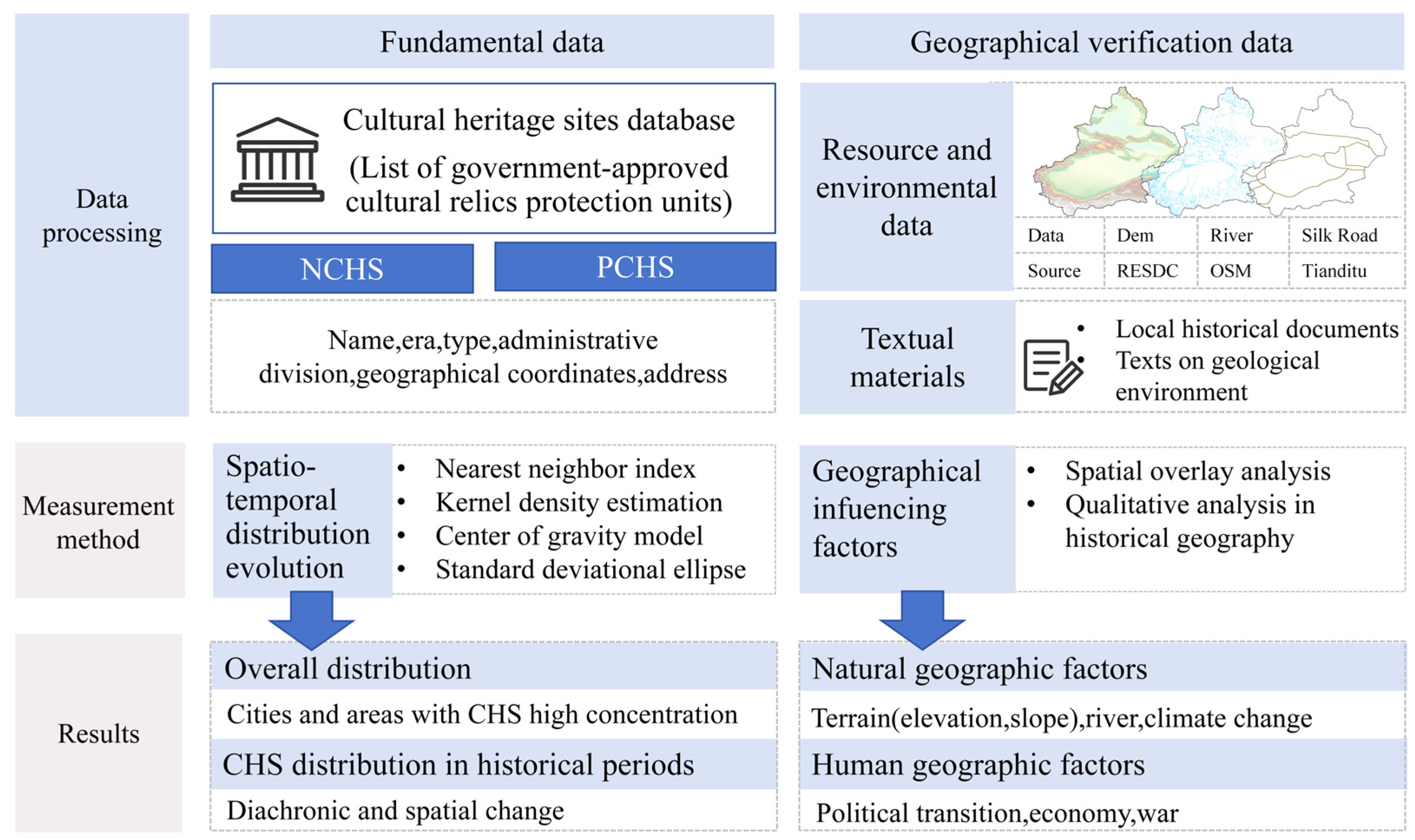
2. Materials and Methods
2.1. Study Area
2.2. Data Sources
2.3. Study Methods
2.3.1. Analysis Methods of Spatio-Temporal Distribution Evolution Characteristics
- (1)
- Nearest neighbor index
- (2)
- Kernel density estimation
- (3)
- Center of gravity model
- (4)
- Standard deviation ellipse
2.3.2. Analysis Methods of Geographical Factors
3. Results
3.1. Spatio-Temporal Distribution Evolution Characteristics
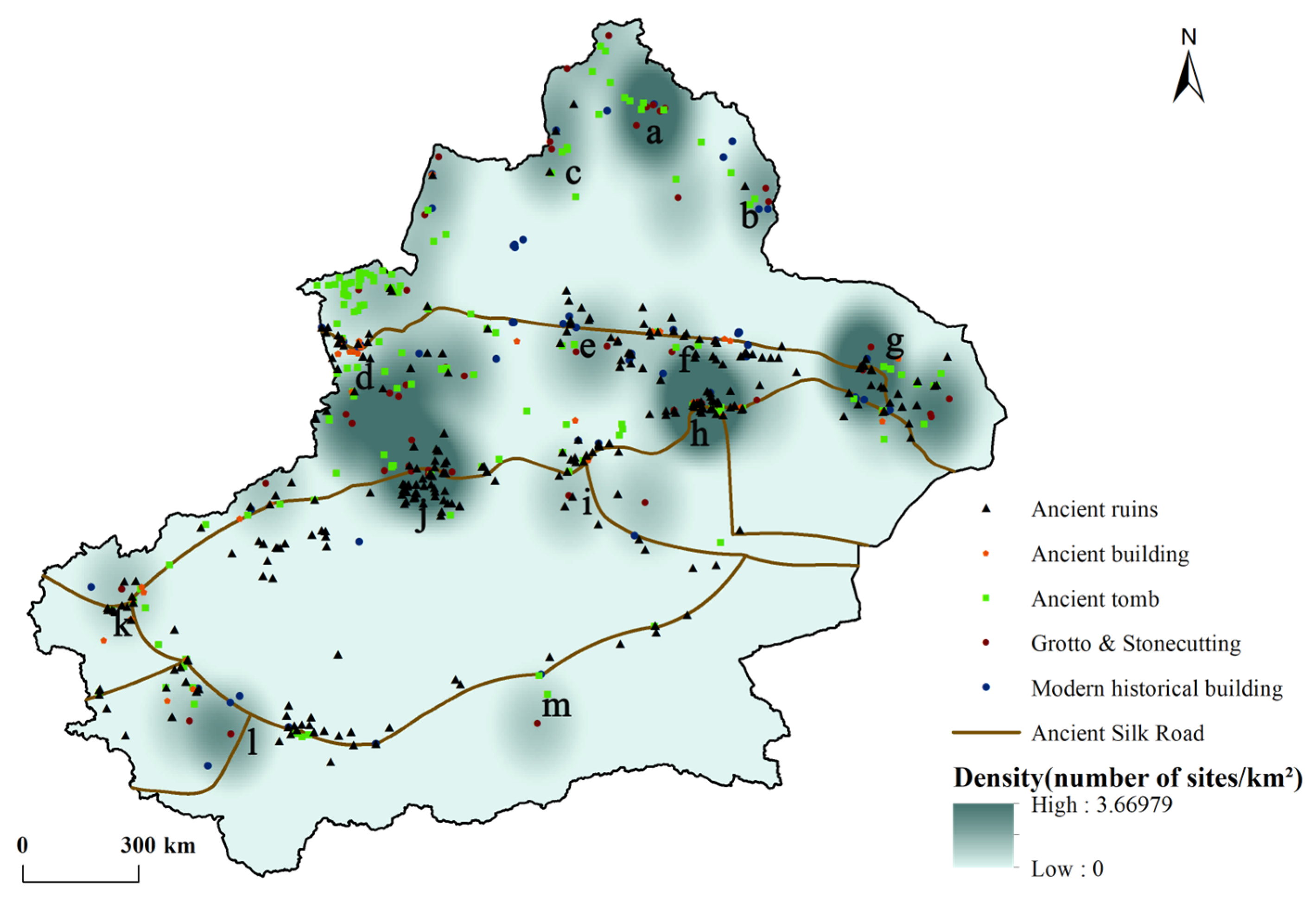
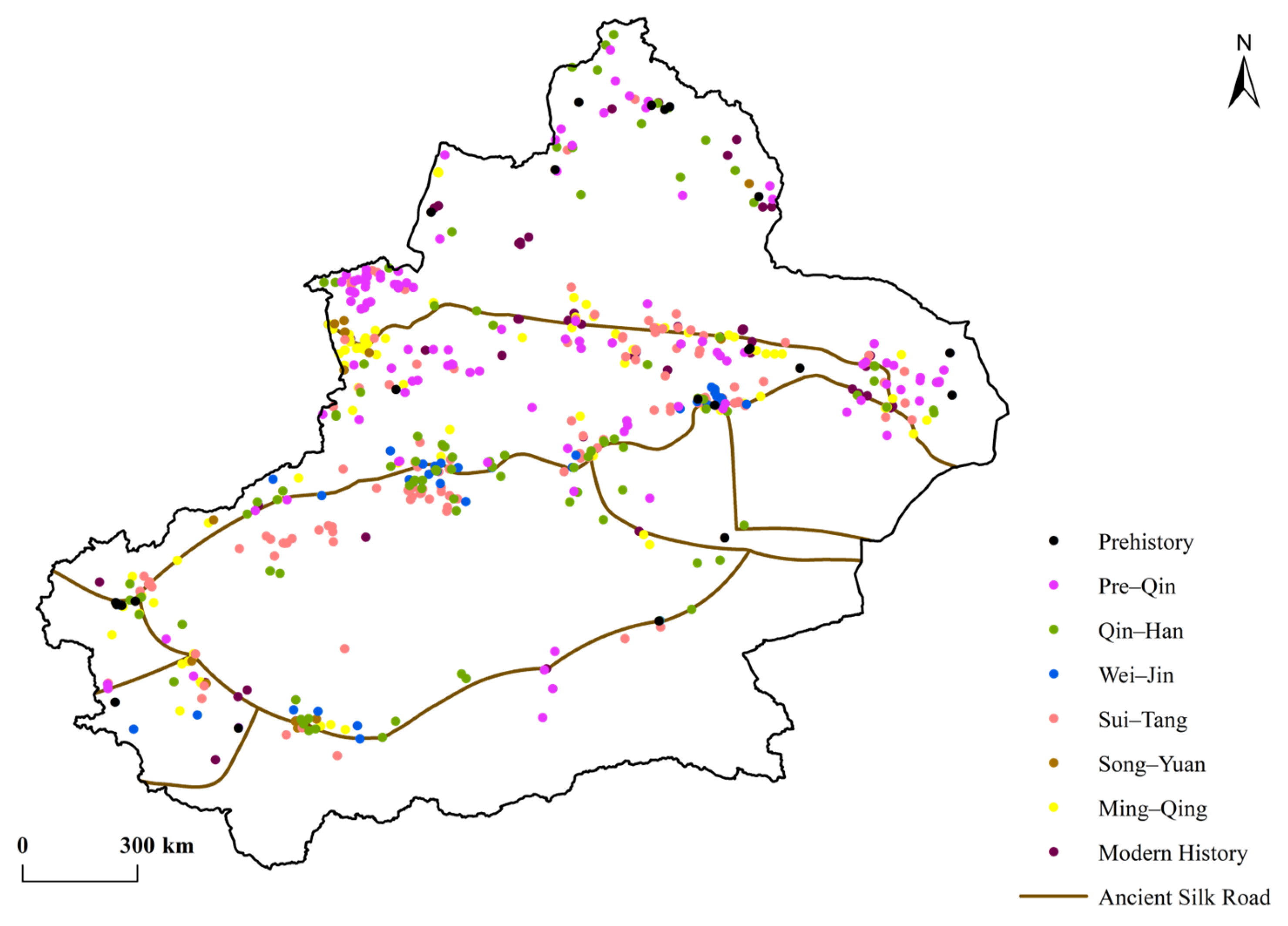
3.1.1. Overall Distribution Characteristics
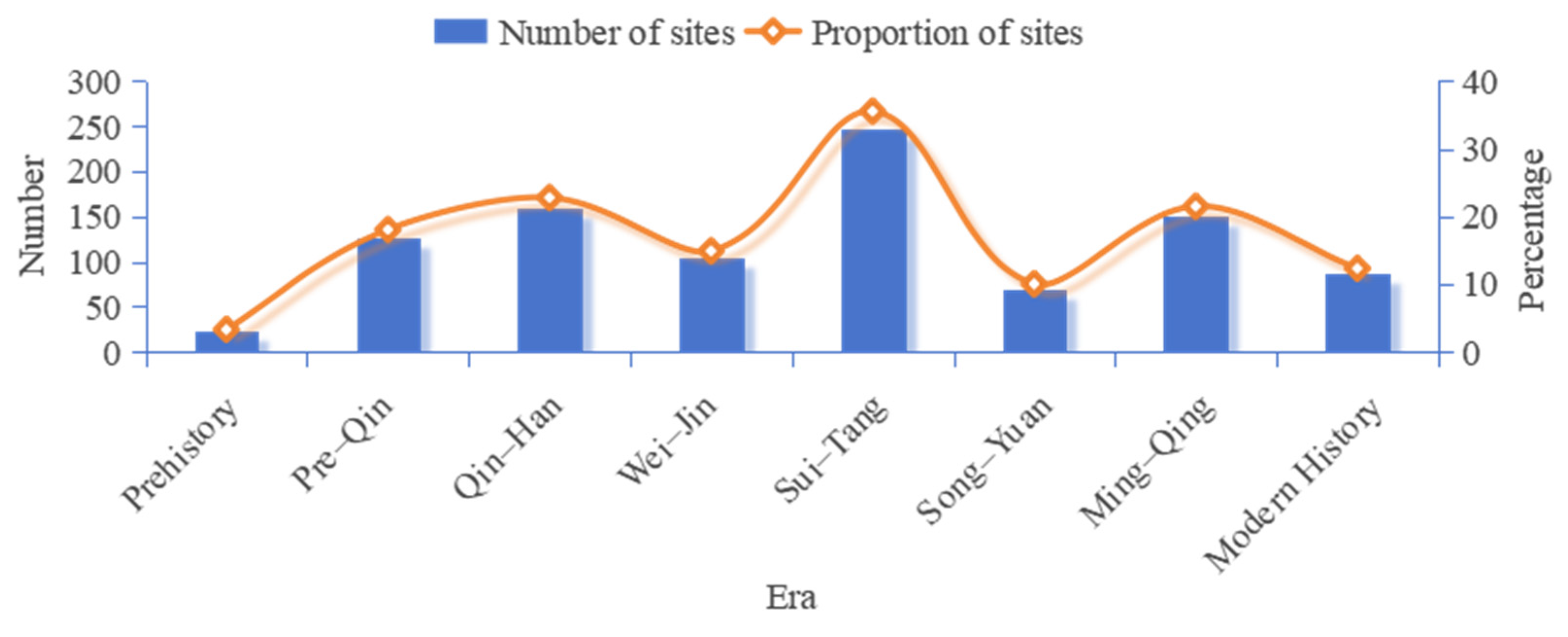
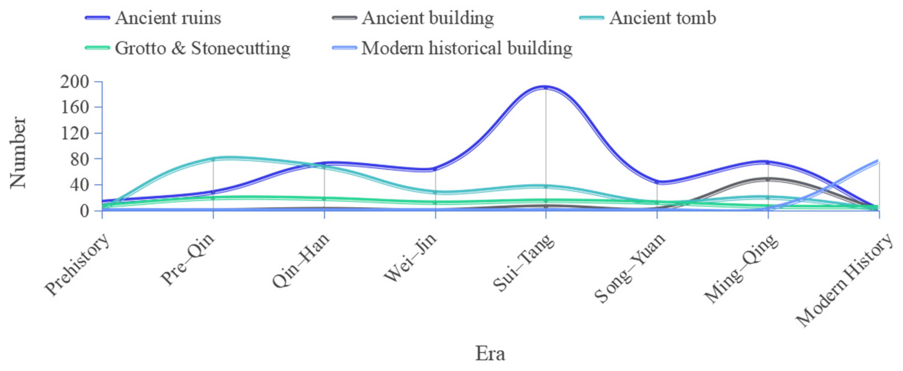
3.1.2. Spatio-Temporal Distribution Characteristics of CHS in Historical Periods
- (1)
- Temporal Distribution Characteristics
- (2)
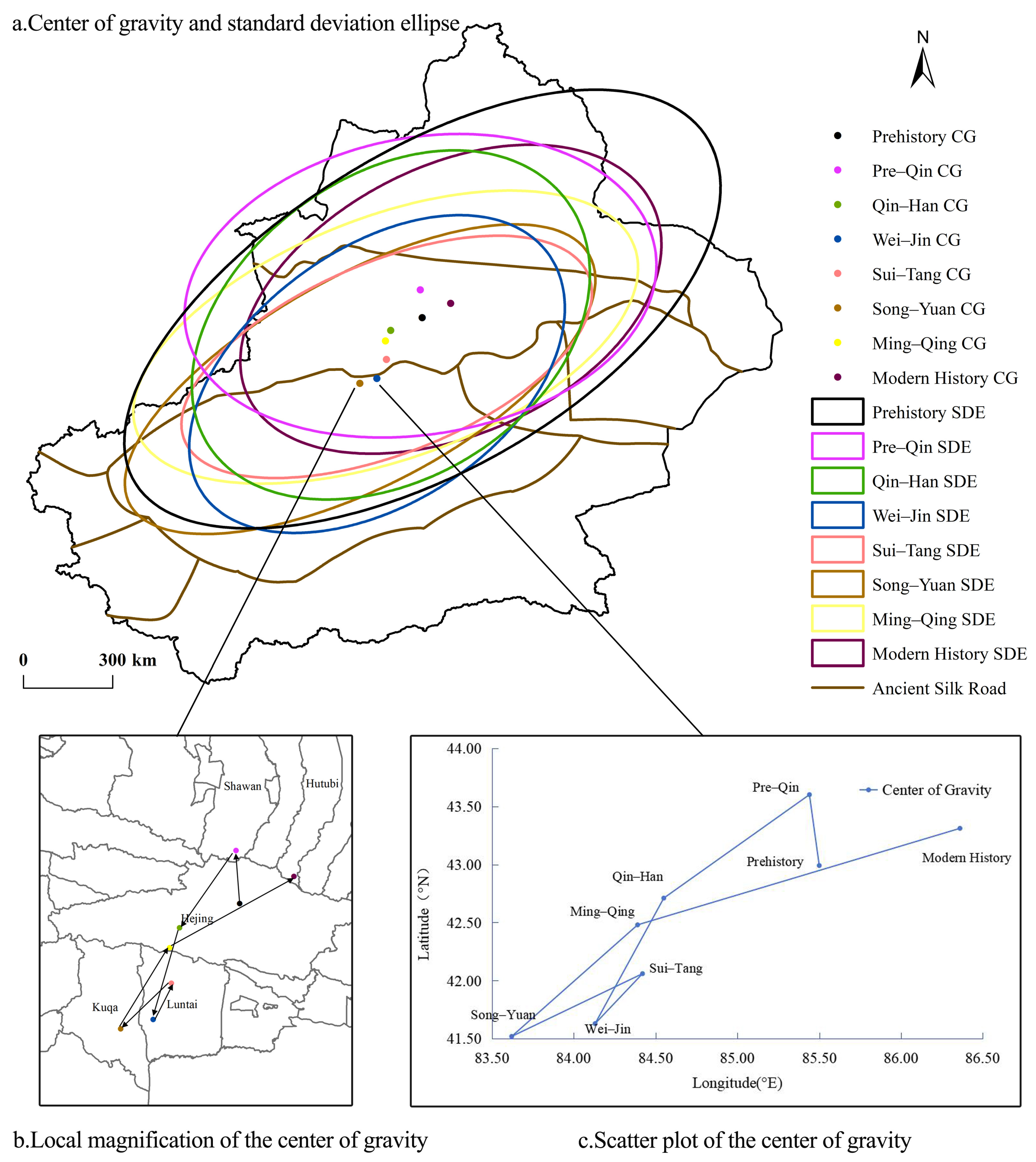
- Spatial distribution characteristics
3.2. Geographical Influencing Factors
3.2.1. Natural Geographical Factors
- (1)
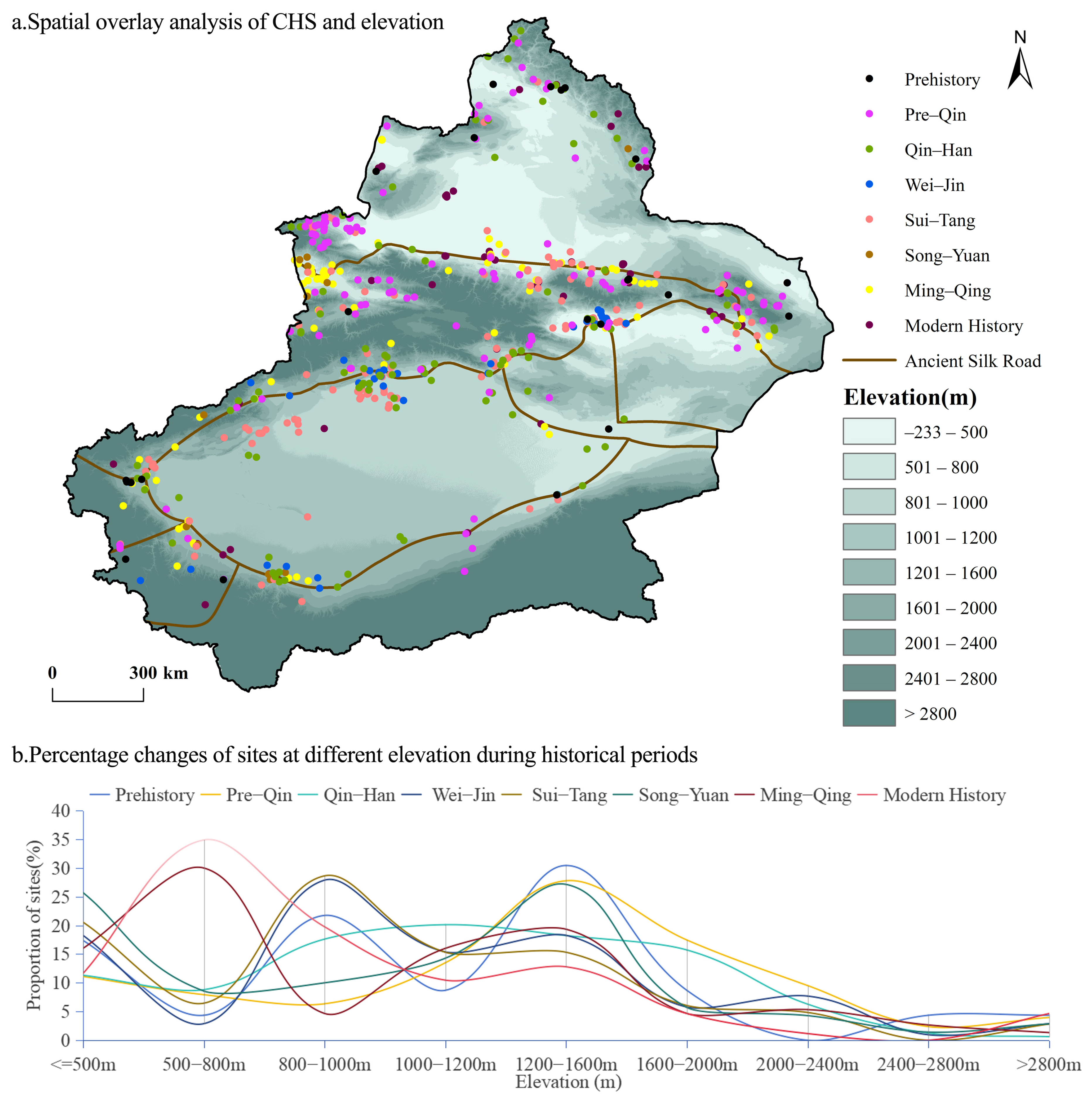
- Terrain
- (2)
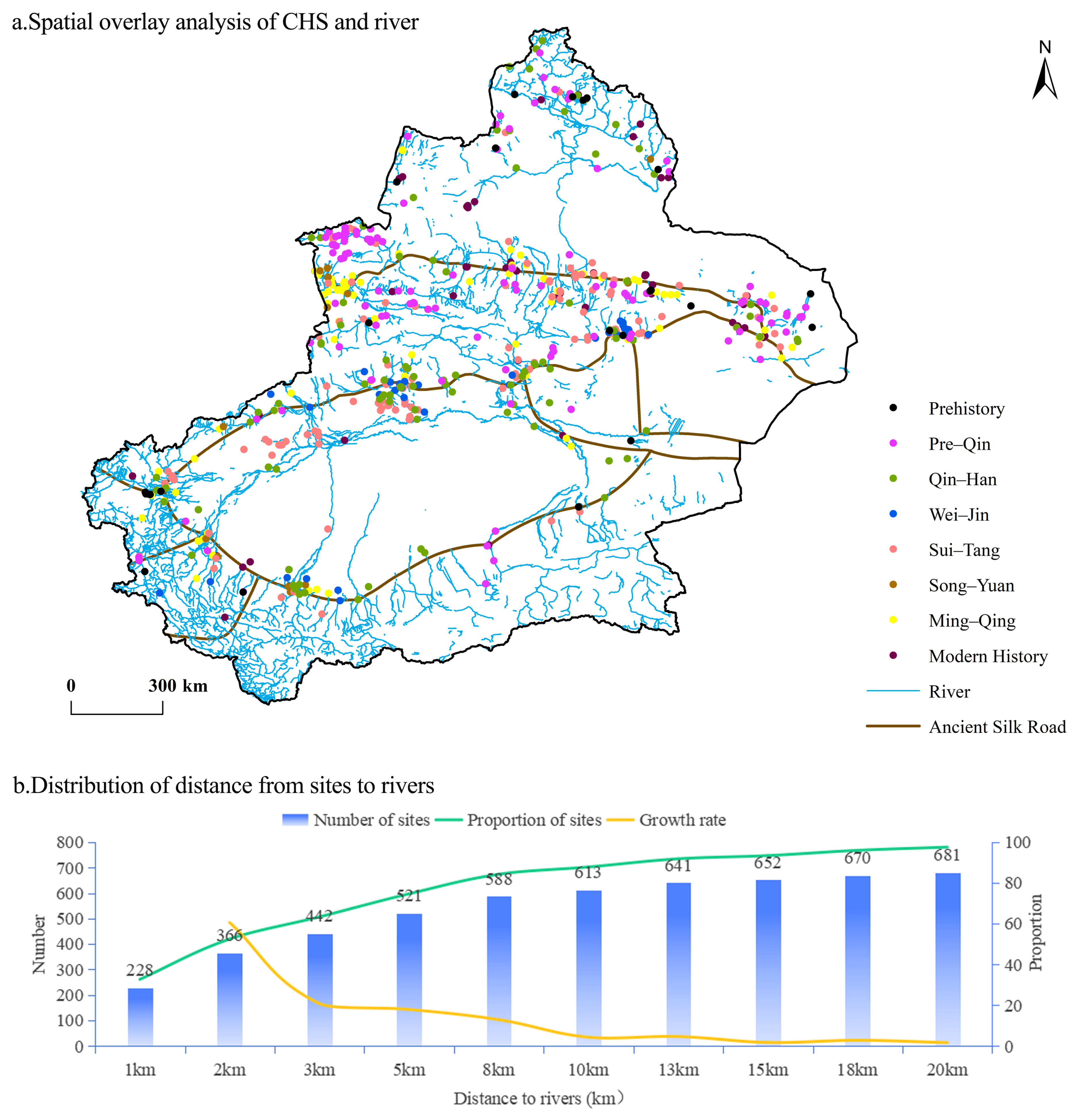
- Rivers
- (3)
- Climate
3.2.2. Human Geography Factors
- (1)
- Political factors
- (2)
- Economic factors
- (3)
- Military war factors
4. Discussion
4.1. Theoretical Implications
4.2. Practical Implications
5. Conclusions
- (1)
- The CHS in Xinjiang features a distribution pattern of multicore agglomeration–linear extension. This pattern is supported by 13 key cities, four major areas with concentrated heritage sites, and the linear extension along the ancient Silk Road routes. The middle and northern route areas of the Silk Road are the most important belts for CHS distribution, accounting for 75.5% of all CHS. The spatial distribution of CHS in Xinjiang obviously correlates with the spatial distribution of the Silk Road.
- (2)
- CHS spatio-temporal distribution evolution is an indicator of regional historical development. The CHS development in Xinjiang across different historical periods shows a wave-like evolution feature of “three peaks and three valleys”. The three peak periods were the three crucial times when Xiyu was unified. The types of CHS have gradually evolved from early tombs to diverse forms, reflecting the transformation of human societies from nomadic to sedentary lifestyles. The center of gravity of Xinjiang’s CHS distribution has undergone a phased shift, starting from a relatively mobile state in the early stage, moving to southern Xinjiang, and then to northern Xinjiang. The shift aligns with the regional historical development center. Distributed along the northeast–southwest axis, CHS show initial concentration followed by diffusion, shaped by the governance characteristics of different ethnic groups, particularly the intensive practices of agricultural communities and the expansive tendencies of nomadic groups.
- (3)
- The CHS distribution shows a tendency to shift from high-elevation mountainous and hilly areas to low-elevation plain areas, and from high-slope areas to low-slope areas. The CHS distribution has shifted from being mainly in elevations of levels 3–5 to being mainly in elevations of levels 1–2. The slope distribution has continuously concentrated in the gentle slope areas of levels 1–2, with the proportion of sites in levels 1–2 increasing from 78.6% in the Pre–Qin period to 93.02% in Modern History. In Modern History, 93.02% of the CHS are distributed within the 10 km buffer zone of rivers, showing a significant water-source orientation. The Xinjiang region has experienced a process of aridification from cold–wet to temperate–dry. Climate change affects the CHS distribution pattern by influencing human production and living conditions.
- (4)
- Natural factors such as climate, landform, and water resources, as well as human-related factors such as regime changes, economic development, and military wars, are the driving factors for the emergence and spatial shifts in CHS in the study area. The analysis of influencing factors reveals a distinctive arid zone pattern, wherein natural factors establish the foundational framework for the basic distribution of CHS, while human activities drive its dynamic evolution. A spatial shift in site distribution—from downstream to mid-upstream areas, and subsequently from mid-upstream to downstream areas—further exemplifies this arid zone pattern, illustrating the relationship between natural resource limitations and adaptive human interventions.
Author Contributions
Funding
Data Availability Statement
Conflicts of Interest
References
- Wang, F.; Yang, Z.; Luan, F.; Xiong, H.; Shi, H.; Wang, Z.; Zhao, X.; Qin, W.; Wu, W.; Li, D. Spatiotemporal Characteristics of Cultural Sites and their Driving Forces in the Ili River Valley during Historical Periods. J. Geogr. Sci. 2015, 25, 1089–1108. [Google Scholar] [CrossRef]
- Ferreira, J. United Nations Educational, Scientific and Cultural Organization (UNESCO). In Encyclopedia of Big Data; Schintler, L.A., McNeely, C.L., Eds.; Springer International Publishing: Cham, Switzerland, 2022; pp. 935–937. [Google Scholar]
- Sylaiou, S.; Tsifodimou, Z.E.; Evangelidis, K.; Stamou, A.; Tavantzis, I.; Skondras, A.; Stylianidis, E. Redefining Archaeological Research: Digital Tools, Challenges, and Integration in Advancing Methods. Appl. Sci. 2025, 15, 2495. [Google Scholar] [CrossRef]
- Hu, H. Spatial Synergy Between Cultural Heritage and Metro Networks: A Case Study of Distribution Patterns and Value Assessment in Beijing. Sustainability 2025, 17, 1666. [Google Scholar] [CrossRef]
- Li, C.; Qian, Y.; Li, Z.; Tong, T. Identifying Factors Influencing the Spatial Distribution of Minority Cultural Heritage in Southwest China. Herit. Sci. 2024, 12, 1–16. [Google Scholar] [CrossRef]
- Jiao, M.; Lu, L. Spatiotemporal Distribution of Toponymic Cultural Heritage in Jiangsu Province and its Historical and Geographical Influencing Factors. Herit. Sci. 2024, 12, 1–25. [Google Scholar] [CrossRef]
- Fu, J.; Mao, H. Study on the Spatiotemporal Distribution Patterns and Influencing Factors of Cultural Heritage: A Case Study of Fujian Province. Herit. Sci. 2024, 12, 324. [Google Scholar] [CrossRef]
- Bachmann-Gigl, U.; Dabiri, Z. Cultural Heritage in Times of Crisis: Damage Assessment in Urban Areas of Ukraine Using Sentinel-1 SAR Data. ISPRS Int. J. Geo-Inf. 2024, 13, 319. [Google Scholar] [CrossRef]
- Santos, B.; Gonçalves, J.; Almeida, P.G.; Martins-Nepomuceno, A.M.T. GIS-based Inventory for Safeguarding and Promoting Portuguese Glazed Tiles Cultural Heritage. Herit. Sci. 2023, 11, 133. [Google Scholar] [CrossRef]
- Peng, Y.; Qiu, H.; Wang, X. The Influence of Spatial Functions on the Public Space System of Traditional Settlements. Sustainability 2023, 15, 8632. [Google Scholar] [CrossRef]
- Chang, Z. Temporal, Spatial Distribution Characteristics, and Influencing Factors of National Key Cultural Relics Protection Units in the Yangtze River Delta. SAGE Open 2024, 14, 1–17. [Google Scholar] [CrossRef]
- Yasar, D.; Heinz, G.K. Spatial Continuum in History: Pier Buildings on the Bosphorus and Golden Horn, Istanbul. Buildings 2024, 14, 3531. [Google Scholar] [CrossRef]
- Tang, Y.; Zhu, L.; Wang, X. Quantitative Analysis of the Evolution of Production-Living-Ecological Space in Traditional Villages: A Comparative Study of Rural Areas in Tibet. Land 2024, 13, 1889. [Google Scholar] [CrossRef]
- Zhang, R.; Martí Casanovas, M.; Bosch González, M.; Sun, S. Revitalizing Heritage: The Role of Urban Morphology in Creating Public Value in China’s Historic Districts. Land 2024, 13, 1919. [Google Scholar] [CrossRef]
- Lv, R.; Liu, Y.; Zhang, L.; Kong, D. Urban Historic Heritage Buffer Zone Delineation: The Case of Shedian. Herit. Sci. 2022, 10, 64. [Google Scholar] [CrossRef]
- Sun, J.; Shao, L. Interpretation of Historic Urban Landscape Genes: A Case Study of Harbin, China. Land 2024, 13, 1988. [Google Scholar] [CrossRef]
- Chatzi, E.; Derdemezi, E.-T.; Tsilimigkas, G. The Impact of Built-Up Area Dispersion on the Cultural Heritage of the Region of the South Aegean, Greece. ISPRS Int. J. Geo-Inf. 2025, 14, 97. [Google Scholar] [CrossRef]
- Garcia-Molsosa, A.; Orengo, H.A.; Petrie, C.A. Reconstructing Long-term Settlement Histories on Complex Alluvial Floodplains by Integrating Historical Map Analysis and Remote-sensing: An Archaeological Analysis of the Landscape of the Indus River Basin. Herit. Sci. 2023, 11, 141. [Google Scholar] [CrossRef]
- Statistics Bureau of Xinjiang Uyghur Autonomous Region. Available online: https://unesdoc.unesco.org/ark:/48223/pf0000132540 (accessed on 17 October 2003).
- The People’s Government of Xinjiang Uygur Autonomous Region. Available online: https://www.xinjiang.gov.cn/xinjiang/xjgk/202307/821947ffb80e4409b1a41f4106318b3a.shtml (accessed on 11 July 2024).
- Luan, F.; Xiong, H.; Wang, F.; Wamh, Z. Spatial-temporal Changes and Man-land Relationship of Cultural Heritage Sites in Xinjiang. Areal Res. Dev. 2017, 36, 134–139. [Google Scholar]
- Liu, C.; Kang, L. How Do Geographical Factors Affect the Distribution of Intangible Cultural Heritage: A Case Study of Xinjiang, China. Sustainability 2023, 15, 8943. [Google Scholar] [CrossRef]
- Tian, X.B.; Hu, J.; Xu, X.; Jia, Y.Y.; Lv, L.; Liu, H.M. Spatio-temporal Distribution Characteristics and Influencing Mechanism of Key Cultural Relics Protection Units in China at Different Historical Periods. Econ. Geogr. 2021, 41, 191–201. [Google Scholar] [CrossRef]
- Jin, A.B.; Zhang, S.Y.; Wang, X.R. Study of the Spatial and Temporal Patterns of Cultural Heritage in Zhejiang Province and Their Association with the Natural Environment: Taking Cultural Relics Protection Units as an Example. Chin. Landsc. Archit. 2022, 38, 22–28. [Google Scholar] [CrossRef]
- Qu, J. Protecting China’s Maritime Heritage: Current Conditions and National Policy. J. Mar. Isl. Cult. 2012, 1, 46–50. [Google Scholar] [CrossRef]
- Xia, Z.K. Classics of Archaeology: Chinese Environmental Archaeology; Bashu Publishing House: Chengdu, China, 2023; pp. 13–27. [Google Scholar]
- Wei, K.; Jiang, X.; Zhu, R.; Duan, X.; Yang, J. Spatial and Temporal Distribution Characteristics of Heritage Buildings in Yangzhou and Influencing Factors and Tourism Development Strategies. Buildings 2025, 15, 1081. [Google Scholar] [CrossRef]
- Charlton, M. Quantitative Data. In International Encyclopedia of Human Geography; Kitchin, R., Thrift, N., Eds.; Elsevier: Oxford, UK, 2009; pp. 19–26. [Google Scholar] [CrossRef]
- Soh, Y.; Hae, Y.; Mehmood, A.; Ashraf, R.H.; Kim, I. Performance Evaluation of Various Functions for Kernel Density Estimation. Open J. Appl. Sci. 2013, 03, 58–64. [Google Scholar] [CrossRef]
- Mitchell, A. The ESRI Guide to GIS Analysis; ESRI Press: Redlands, CA, USA, 2005; Volume 2. [Google Scholar]
- Gong, J. Clarifying the Standard Deviational Ellipse. Geogr. Anal. 2002, 34, 155–167. [Google Scholar] [CrossRef]
- Tong, W.; Yu, Z.; Wu, Y.; Liu, Y.; Hu, W. A Brief Report on the Excavation of Ancient Tombs in Altay Region, Xinjiang. Cult. Relics 2013, 3, 15–19. [Google Scholar] [CrossRef]
- Yi, M.J. Age and Related Issues of Paleolithic Remains in Northern Xinjiang. West. Reg. Stud. 2019, 4, 64–72+144. [Google Scholar] [CrossRef]
- Wang, S. Brushing Away the Dust: Historical Traces of the Xinjiang Section of the Silk Road; SDX Joint Publishing Company: Beijing, China, 2018; pp. 197–217. [Google Scholar]
- Hua, L. A History of Agricultural Development in Xinjiang During the Qing Dynasty; Heilongjiang Education Publishing Press: Harbin, China, 1998; pp. 87–88. [Google Scholar]
- Zhang, X.Y.; Xie, Y.W.; Zhu, L.Q.; Guo, Z.C.; Wang, H.R.; Xi, G.L. Analysis of the Spatial Distribution Characteristics of Cultural Relics Sites in Xinjiang in Historical Periods. J. Arid Land Resour. Environ. 2023, 37, 109–116. [Google Scholar] [CrossRef]
- Zhu, L.Q.; Wang, X.Y.; Liu, J.M.; Xie, Y.W. Distribution of Historical Sites and Their Natural Environmental Background in the Hexi Region of Gansu. J. Desert Res. 2021, 41, 121–128. [Google Scholar]
- Zhang, D.J.; Dong, G.H.; Wang, H.; Ren, X.Y.; Ha, P.P.; Qiang, M.R.; Chen, F.H. History and possible mechanisms of prehistoric human migration to the Tibetan Plateau. Sci. China-Earth Sci. 2016, 59, 1765–1778. [Google Scholar] [CrossRef]
- Qian, Y. Evolution and Development of Oases in Xinjiang in Historical Periods. J. Arid Land Resour. Environ. 1997, 2, 38–48. [Google Scholar]
- Zhang, L.; Lu, S.M. Analysis of the River Channel Evolution and Its Influencing Factors in the Middle and Lower Reaches of Hutubi River in Xinjiang in the Past 250 Years. West. Reg. Stud. 2020, 3, 80–93+171. [Google Scholar] [CrossRef]
- Jiang, F.Q.; Hu, R.J.; Ma, H. Past, Present and Future Scenarios of Climate and Environment in Xinjiang. Arid Land Geogr. 1998, 1, 1–9. [Google Scholar] [CrossRef]
- Jiang, X.Y.; Li, Z.Z.; Chen, X.L.; Jin, J.H. Pollen Records and Climate Change in the Late Holocene Aeolian Deposits in the Yili River Valley, Xinjiang. J. Desert Res. 2011, 31, 855–861. [Google Scholar]
- Zhang, Y.; Kong, Z.C.; Ni, J.; Yan, S.; Yang, Z.J. Pollen Records and Environmental Evolution since 4550 Years BP in the Caotanhu Village Wetland, Xinjiang. Chin. Sci. Bull. 2008, 53, 306–316. [Google Scholar]
- Tian, W. A Concise History of Xinjiang; Xinjiang People’s Publishing Press: Urumqi, China, 2009; pp. 16–45. [Google Scholar]
- Feng, X.H.; Yan, S.; Ni, J.; Kong, Z.C.; Yang, Z.J. Lake—Level Fluctuations and Environmental Changes in the Late Holocene Recorded by Plain Lakes in Northern Xinjiang. Chin. Sci. Bull. 2006, S1, 49–55. [Google Scholar] [CrossRef]
- Wang, W.; Feng, Z.; Ran, M.; Zhang, C. Holocene Climate and Vegetation Changes Inferred from Pollen Records of Lake Aibi, Northern Xinjiang, China: A Potential Contribution to Understanding of Holocene Climate Pattern in East-central Asia. Quat. Int. 2013, 311, 54–62. [Google Scholar] [CrossRef]
- Yan, S.; Mu, G.J.; Kong, Z.C.; Ni, J.; Yang, Z.J. Environmental Evolution and the Impact of Human Activities in the Late Holocene on the Northern Slope of the Tianshan Mountains. J. Glaciol. Geocryol. 2004, 4, 403–410. [Google Scholar]
- Ju, Y.J.; Liu, G.N. Climate and Environmental Changes in the Headwaters of the Urumqi River since 4000 a BP Revealed by Pollen Records. J. Glaciol. Geocryol. 2004, 2, 166–170. [Google Scholar]
- Ding, G.; Chen, J.; Lei, Y.; Lv, F.; Ma, R.; Chen, S.; Ma, S.; Sun, Y.; Li, Y.; Wang, H.; et al. Precipitation Variations in Arid Central Asia over Past 2500 Years: Possible Effects of Climate Change on Development of Silk Road Civilization. Glob. Planet. Change 2023, 226, 104142. [Google Scholar] [CrossRef]
- Chen, F.H.; Huang, X.Z.; Zhang, J.W.; Holmes, A.H.; Chen, J.H. Study on the Moist Climate during the Little Ice Age in the Arid Region of Inland Asia Recorded by Bosten Lake in Xinjiang. Sci. China (Ser. D Earth Sci.) 2007, 1, 77–85. [Google Scholar]
- Yao, T.D.; Qin, D.H.; Tian, L.D.; Jiao, K.Q.; Yang, Z.H.; Xie, C.; Thompson, L.G. Temperature and Precipitation Changes on the Tibetan Plateau over the Past 2000 Years—Records from the Guliya Ice Core. Sci. China (Ser. D Earth Sci.) 1996, 4, 348–353. [Google Scholar]
- Bao, Y.; Braeuning, A.; Yafeng, S.; Fahu, C. Evidence for a Late Holocene Warm and Humid Climate Period and Environmental Characteristics in the Arid Zones of Northwest China during 2.2–1.8 kyr B.P. J. Geophys. Res. Atmos. 2004, 109, D02105. [Google Scholar] [CrossRef]
- Liu, H.F.; Che, Z.C. Jurassic Palynostratigraphy in the Chaiwopu Basin, Xinjiang. J. Stratigr. 1998, 22, 27–37. [Google Scholar] [CrossRef]
- Li, S. History and Current Situation of Xinjiang, China; Xinjiang People’s Publishing Press: Urumqi, China, 2009; pp. 6–26. [Google Scholar]
- Hou, C. Research on the History and Archaeology of the Western Regions; Zhongxi Publishing Press: Shanghai, China, 2019; pp. 71–86, 309–329. [Google Scholar]
- Miao, P. Essays on Xinjiang History; Northwest University Press: Xi’an, China, 2020; pp. 67–84. [Google Scholar]
- Huang, C. A Summary of the Western Frontier; Chengwen Publishing Press: Taipei, China, 1968; pp. 25–32. [Google Scholar]
- Chen, X. The Opening of the Silk Road and Its Influence on Xinjiang’s History. West. Reg. Stud. 2013, 3, 10–16+154. [Google Scholar] [CrossRef]
- Bao, Q.D. A Review of Nomadic Civilization: Research on Survival Wisdom and Its Ecological Dimension. Inn. Mong. Soc. Sci. (Chin. Ed.) 2015, 36, 145–153, 181. [Google Scholar] [CrossRef]
- Xing, L. The Integration of Nomadic Culture and Farming Culture from the Perspective of the Construction of the Chinese Cultural Community. J. Yunnan Norm. Univ. (Philos. Soc. Sci. Ed.) 2022, 54, 88–96. [Google Scholar]
- Xiong, H.G.; Zhong, W.; Tashpolat, T.; Hemit, H.; Nurbay, N.; Takamura, K.; Suzuki, Y.; Shimazu, M. Coupling Relationship between Natural and Humanistic Historical Changes on the Southern Margin of the Tarim Basin. Acta Geogr. Sin. 2000, 2, 191–199. [Google Scholar]


| Semimajor Axis (km) | Semiminor Axis (km) | Rotation Angle (°) | Area (km2) | |
|---|---|---|---|---|
| Prehistory | 9.53 | 3.73 | 69.27 | 111.77 |
| Pre–Qin | 7.16 | 3.27 | 84.49 | 73.59 |
| Qin–Han | 6.21 | 3.56 | 72.26 | 69.53 |
| Wei–Jin | 5.98 | 3.07 | 68.51 | 57.66 |
| Sui–Tang | 6.4 | 2.22 | 74.7 | 44.67 |
| Song–Yuan | 7.53 | 2.5 | 69.61 | 59.02 |
| Ming–Qing | 7.82 | 2.78 | 76.29 | 68.32 |
| Modern History | 6.53 | 3.07 | 75.2 | 63.03 |
| Prehistory | Pre–Qin | Qin–Han | Wei–Jin | Sui–Tang | Song–Yuan | Ming–Qing | Modern History | |
|---|---|---|---|---|---|---|---|---|
| 1 km | 9 | 44 | 46 | 24 | 67 | 24 | 59 | 33 |
| 5 km | 17 | 86 | 107 | 69 | 175 | 55 | 118 | 74 |
| 10 km | 21 | 103 | 128 | 80 | 208 | 64 | 139 | 80 |
| 15 km | 21 | 113 | 141 | 89 | 231 | 66 | 144 | 82 |
| 20 km | 21 | 120 | 150 | 97 | 239 | 67 | 148 | 86 |
Disclaimer/Publisher’s Note: The statements, opinions and data contained in all publications are solely those of the individual author(s) and contributor(s) and not of MDPI and/or the editor(s). MDPI and/or the editor(s) disclaim responsibility for any injury to people or property resulting from any ideas, methods, instructions or products referred to in the content. |
© 2025 by the authors. Licensee MDPI, Basel, Switzerland. This article is an open access article distributed under the terms and conditions of the Creative Commons Attribution (CC BY) license (https://creativecommons.org/licenses/by/4.0/).
Share and Cite
Zhengchen, R.; Liu, J.; Ren, J.; Zhang, S.; Liu, B. Spatio-Temporal Distribution Evolution Characteristics and Geographical Influencing Factors of Cultural Heritage Sites in Xinjiang, China. Land 2025, 14, 974. https://doi.org/10.3390/land14050974
Zhengchen R, Liu J, Ren J, Zhang S, Liu B. Spatio-Temporal Distribution Evolution Characteristics and Geographical Influencing Factors of Cultural Heritage Sites in Xinjiang, China. Land. 2025; 14(5):974. https://doi.org/10.3390/land14050974
Chicago/Turabian StyleZhengchen, Rouyu, Jiaming Liu, Jiamin Ren, Shuying Zhang, and Bingzhi Liu. 2025. "Spatio-Temporal Distribution Evolution Characteristics and Geographical Influencing Factors of Cultural Heritage Sites in Xinjiang, China" Land 14, no. 5: 974. https://doi.org/10.3390/land14050974
APA StyleZhengchen, R., Liu, J., Ren, J., Zhang, S., & Liu, B. (2025). Spatio-Temporal Distribution Evolution Characteristics and Geographical Influencing Factors of Cultural Heritage Sites in Xinjiang, China. Land, 14(5), 974. https://doi.org/10.3390/land14050974