Abstract
Scientific route selection is the premise of constructing the Grand Canal National Trails (GCNTs). How to highlight the historical and cultural characteristics of the cities along the Grand Canal and meet the diverse needs of urban residents and tourists through GCNTs while considering the reality is an important goal of the route selection research. Taking the old town of Jining City as an example, this study proposes a theoretical framework for route selection of the GCNTs based on resource connectivity, spatial continuity, and residents’ promotion, with a realization path of “three sections and six steps”. The results show that the optimal connection path between “canal–resource–community” can be found through systematic methods such as the optimized minimum cumulative resistance (MCR) model and space syntax, and the “main route–branch route–connection route” system of the GCNTs can be constructed. The GCNTs closely connect the canals, 59 resources, and 352 communities into an integral spatial network, forming a complete canal cultural narrative system and path. The results offer theoretical and methodological support for the route selection of GCNTs in 35 prefecture-level cities and 150 districts and counties along the Grand Canal, providing reference for route selections of similar related concepts in central urban areas.
1. Introduction
A trail is a travel way established either through construction or use that is passable by at least one or more of the following, including but not limited to foot traffic; stock; watercraft; bicycles; in-line skates; wheelchairs; cross-country skis; and off-road recreation vehicles such as motorcycles, snowmobiles, all terrain vehicle (ATVs), and 4-wheel drive vehicles. Trails can not only meet people’s growing leisure needs and provide people with outdoor leisure and recreation places but also rationally develop and utilize natural, historical, and cultural resources, so that these rare and valuable resources can be protected and sustainably utilized [1]. As the initiator of the trail concept and the pioneer of construction, the United States has formed a national trail network of more than 1380 trails [2,3] since the construction of the first trail, the Appalachian Trail, in the 1930s. The United Kingdom, France, Australia, and other countries have also launched national trail construction actions, and a national trail network covering the whole area has been built at the national level [4]. The construction of national trails has become an important way to show the brand image of the country’s important natural, historical, and cultural resources; promote the development of outdoor sports fitness and leisure and recreation activities; and promote the comprehensive development of regional economy and society [5]. The number of trails around the world is increasing, and trails are becoming an important medium for modern recreational activities worldwide [6].
In recent years, with the increasing improvement in China’s economic strength and people’s living standards, the layout of China’s national trail system construction has begun. In 2022, the General Office of the State Council of the People’s Republic of China issued the Opinions on Building a Higher-Level National Fitness Public Service System [7], which put forward the overall requirements for the establishment of a national trail system and the spatial layout of “three verticals and four horizontals”1, aiming to fully display the brand image of national resources such as the Grand Canal, the Silk Road, the Yellow River, and the Yangtze River to the world; provide support for future outdoor activities; and promote the development of higher-level national fitness activities. In July 2024, the National Development and Reform Commission (NDRC) of China issued the Implementation Plan for the Construction of the Grand Canal National Trails [8], proposing an implementation plan and specific measures to basically realize the full connection of the Grand Canal National Trails (GCNTs) by 2027. Spanning 6 provinces, 2 centrally administered municipalities, 35 prefecture-level cities, and 150 districts and counties, the Grand Canal will soon build the first national trail in China. For the Grand Canal, which has multiple brand identities such as world cultural heritage and national cultural parks, this action will play an important role in promoting the protection, inheritance, and utilization of its natural, historical, and cultural resources, as well as the promotion of sports fitness and leisure and recreation activities of urban residents and tourists along the trails.
The route selection is the primary problem faced by the construction of the GCNTs. The Technical Standard for the Construction of the Grand Canal National Trail [9] points out that the GCNTs are divided into two types: urban and suburban, and the route selection should reflect the effective integration of local resources, full utilization and coherence of trails, and the motivation and satisfaction demand of residents and tourists. In particular, the 3200-km-long Grand Canal passes through a large amount of central urban areas, the physical space of the city has been closely adjacent to the Grand Canal since ancient times, and the lives of urban residents have always been closely related to the Grand Canal. Therefore, facing the central urban areas with a high density of buildings and population, the issue is how to make the GCNTs better connect the rich natural and cultural resources of the old town; be efficiently and smoothly connected in the limited spaces of the main urban area; and organically combine with the daily life of urban residents such as sports fitness, healthy leisure, and cultural cognition, as well as the tourism and protection of canal heritage [10], which is undoubtedly a key scientific issue to guide the route selection of the GCNTs in the urban section.
Judging from the research progress around the world in recent years, route selection is one of the research focuses of trails and similar concepts such as greenways, parkways, heritage corridors, and green infrastructure networks. Most of the research methodologies use the minimum cumulative resistance (MCR) model as the basic algorithm and find the minimum cost path between resources in the research area through four steps: (1) source and sink points selection, (2) resistance surface construction, (3) spatial network generation, and (4) to optimize and grade the generated network to construct a network system with whole coverage and a clear structure. Since its proposal in the 1990s [11,12], this method has been widely used in macro-regional studies such as national parks [13,14], provincial (municipal) areas [15,16], river basins [17], and cross-regional linear cultural heritage [18,19], as well as meso-scale studies such as central urban areas [20,21,22,23], and has achieved good theoretical and application results. In the face of high-density integrated central urban areas such as population, resources, and land use categories, some scholars have explored the optimization of traditional methods and procedures. For example, Zhou et al. [24] used the MCR model to generate the physical spatial routes of urban heritage corridors and constructed a co-word matrix to complete the route planning upon social semantic data analysis and superimpose the two-route planning results of the heritage corridor in the old town of Nanjing. Lu et al. [25] constructed a suitability evaluation system to determine a potential greenway line and used neural network model training to obtain the optimal greenway line from Xixi Wetland to Nanhu Greenway in Yuhang District. Chen et al. [26] selected a detailed classification of land use categories to construct a resistance surface, used the MCR model to construct a security pattern of Chaozong Street in Changsha City, and proposed an elastic protection framework for the cultural landscape security pattern. Wang et al. [27] constructed a resistance surface based on both natural and social factors and applied the MCR model and the gravity model to select and grade the cultural heritage corridor in the historic city of Tianjin. The optimization method adopted in the above research makes the four steps of route selection described above more scientific and rational.
In terms of the route selection of the GCNTs in high-density central urban areas, there are still three shortcomings in the above methods:
- (1)
- The GCNTs must forge robust connections with a variety of resources and user groups [9]. In some routing studies [27], natural and cultural resources within urban areas were utilized as source and sink points, clearly demonstrating the connectivity between “resources and resources”. However, when choosing source and sink points in high-density urban areas, the role of trails in connecting the numerous existing urban communities [28] cannot be overlooked, thereby enabling trails to fully realize their function of linking “resources and people”.
- (2)
- The GCNTs should fully harness their potential to invigorate cultural, tourism, and related industries along the route [9]. Some studies [26] have considered spatial factors such as land use types within the built environment when constructing a resistance surface. However, the key social factors in high-density urban areas, including residents’ accessibility, convenience, and the feasibility of travel, were neglected. Consequently, the least-costly paths generated from these simulations may not accurately reflect the trail’s potential to stimulate outdoor recreation, attract tourism, and foster economic development [29].
- (3)
- The GCNTs must ensure continuous connectivity [9], as continuity is a prerequisite for achieving the sustainability of the trail system [30]. When constructing the resistance surface in high-density urban areas, some studies [24] treated spatial elements like municipal roads and green spaces as a single, uniform resistance surface. However, this approach fails to reflect the actual condition where a large number of long-established pedestrian spaces exist within these built-up areas. Consequently, the trail network generated through such a method may be difficult to realize in practice in terms of achieving true continuity.
Obviously, in order to better meet the specific requirements of trail route selection in such contexts, traditional methodologies need to be optimized based on the characteristics of the GCNTs and high-density central urban areas.
Therefore, this study aims to propose a theoretical framework for the construction of the GCNTs and to explore the route selection methods for the GCNTs in high-density central urban areas. Centering on resource connectivity, spatial continuity, and the promotion of residents’ well-being, this research utilizes the optimized MCR model and space syntax analysis to conduct a route selection study for GCNTs in the old town of Jining City, Shandong Province. The objective is to offer theoretical and methodological support for the route selection of GCNTs in urban areas along the Grand Canal. This will effectively aid in the protection, inheritance, and utilization of natural, historical, and cultural resources in canal-side cities, as well as promote daily urban activities such as physical exercise, health, and leisure for local residents.
2. Materials and Methods
2.1. Research Idea and Methods
2.1.1. Theoretical Framework
According to the Technical Standard [9], the GCNTs are established along the main channels and tributaries of the Grand Canal, connecting the resources along the canal. They meet the people’s needs for experiencing nature, understanding heritage, and engaging in sports and fitness and leisure and recreation. Furthermore, they showcase the significant historical and cultural importance and value of the Grand Canal in China. The close connectivity between the trails and various resources and user groups; the continuous integration of trails; and the trails’ potential to stimulate cultural, tourism, and other related industries are the overall requirements for the construction of the GCNTs. The goals of national trails, as widely recognized in the United Kingdom’s National Trails Management Standards [31] and the National Trails System Act of the United States [3], include presenting the iconic image of significant national natural and cultural resources, promoting outdoor physical and recreational activities, and driving the comprehensive development of regional economies and societies. These points have also been extensively elaborated upon in the studies of Vizmpa [28], Kolkos [29], and Raichel [30].
Based on this, the study proposes a theoretical framework for the construction of the GCNTs from three aspects: connectivity, continuity and promotion (Figure 1).
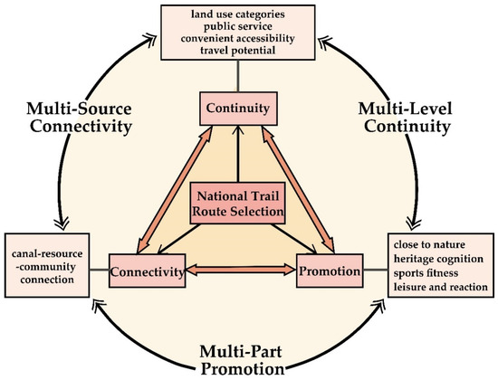
Figure 1.
The theoretical framework for constructing the route selection of GCNTs for high-density central urban areas.
- (1)
- Connectivity: “Multi-Source Connectivity” with the ancient and modern canals system as the main vein.
Sort out the functional relationship and evolution of the Grand Canal and urban spaces in different historical periods and clarify the optimal connection between “canal–resource–community” and the national trails with the ancient and modern canals system as the main vein, and the national trails can fully demonstrate the historic Grand Canal culture and the rich and diverse resources of the old town and the Grand Canal to urban residents and tourists.
- (2)
- Continuity: “Multi-Level Continuity” based on the actual spatial conditions around the canal.
The route selection of the national trails should fully consider the actual situation that there are a large number of long-existing pedestrian spaces across diverse land use categories within high-density central urban areas, so as to realize the practical operability of the national trails for the connection between “canal–resource–community”.
- (3)
- Promotion: “Multi-Part Promotion” based on the complexity of high-density central urban areas.
At the spatial level, it reflects the complex situation of diverse land use categories in high-density central urban areas. At the social level, the comprehensive factors such as high population density and large number of communities in the central urban areas of high-density cities are systematically considered. Based on the four aspects of land use categories, public service, convenient accessibility, and travel potential, the route selection emphasizes the driving role of the GCNTs system in meeting the needs of urban residents and tourists, as well as the tourism and protection of canal heritage [10].
2.1.2. Research Methods and Technical Pathways
The technical pathway of this study is divided into “three sections” and “six steps”, as shown in Figure 2. The following analysis was conducted using ArcGIS 10.8 software.
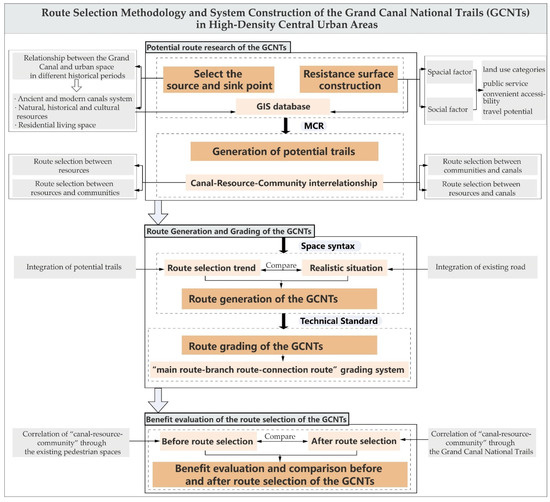
Figure 2.
The technical pathway of route selection method of the Grand Canal National Trails (GCNTs).
- Section 1: Potential route research of the Grand Canal National Trails
- Step 1: Select the source and sink points
- From the perspective of functional relevance, the ancient and modern canals system, such as the main channels, the first-class tributaries, and hydraulic engineering facilities, are clarified. From the perspective of historical relevance, diverse historical and cultural resources in the old town are clarified. From the perspective of sports and recreation activities relevance, it is necessary to clarify the residential communities, parks, green spaces, squares, and other places that are closely related to the daily lives of urban residents along the canal.
- For the above-mentioned ancient and modern canals system and facilities, various resources, places, and communities are regarded as source and sink points, and a complete resource database is constructed in GIS.
- Step 2: Resistance surface construction
- In GIS, a complete basic database including land use categories, public service facilities, road traffic facilities, and population density and so on in the old town is constructed.
- From the two levels of spatial factors and social factors, the resistance factors reflecting the actual situation of the old town were comprehensively selected, and the comprehensive resistance surface was constructed in GIS from four aspects: land use categories, public service, convenient accessibility, and travel potential.
- In the construction of the comprehensive resistance surface, the actual conditions of walking and cycling in various categories of land use in the old town are carefully considered, and the various pedestrian spaces in the urban area that have been built and used for many years but are not continuous are fully combined.
- Step 3: Route generation of potential trails
- The selection of source and sink points and the construction of a resistance surface are the key to establishing the MCR model [32]. Based on the above two steps, the cost distance between the source and sink points on the comprehensive resistance surface is generated by using the cost distance tool in GIS, the cost path tool and cost connectivity tools in GIS are used to generate the minimum cost paths, and the route selection of potential trails is obtained by superimposing multiple cost paths.
The formula is as follows:
In Equation (1), MCR is the minimum cumulative resistance value, fmin is the positive correlation between the minimum cumulative resistance and the ecological process [23], Dij is the distance from a point i in space to the destination point j, and Ri is the resistance coefficient in the process of spatial expansion of a point i in space.
- Section 2: Route Generation and Grading of the Grand Canal National Trails
- Step 4: Route generation of the National Trails
- The space syntax method [33,34] is used to select the integration index [35,36] to evaluate the route selection of potential trails and the existing road. The potential route selection trend is coupled and compared with the actual road conditions, and the final route selection of the GCNTs is obtained by comprehensively interpreting the potential possibility and realistic availability of the trails.
The formula is as follows:
Integration (NQPD) can also be referred to as the proximity or proximity to centrality, which has a similar meaning to accessibility. In Equation (2), x is the road section to be calculated, Rx is the set of other road sections that can be reached within a given radius R starting from the road section x, W(y) is the weight of the road section y, which can represent the length of the road section or the number of points of interest, d(x,y) is the distance between the road section x and y, including the Euclid distance or the angular distance [37], etc., and P(y) denotes the proportion of the segment y in Rx. In discrete space, P(y) = 1, y∈Rx and P(y) = 0, y∉Rx. In continuous space, P(y) is the proportion of the length of the section y within the radius R.
- Step 5: Route grading of the National Trails
Based on the results of the space syntax analysis and the requirements of the Technical Standard [9], the “main route–branch route–connection route” system of the GCNTs in the old town is clarified.
- Section 3: Benefit evaluation of the Grand Canal National Trails
- Step 6: Benefit evaluation and comparison before and after the route selection of the national trails
The average walking distance for an ordinary person in 5 min is approximately 400 m [38,39]. Based on this behavioral pattern, the fishing net tool of GIS is used to divide the old town into 285 grids of 400 m × 400 m, and each grid was used as a spatial unit to calculate the correlation between the existing pedestrian spaces and “canal–resource–community” before route selection and the correlation degree between the GCNTs and “canal–resource–community” after route selection, and the correlation degree before and after route selection was compared so as to explain the overall benefit of route selection of the GCNTs.
2.2. Study Area
The study area is the old town of Jining City, Shandong Province, which is composed of Fuqiao Street, Guhuai Street, Jincheng Street, Guanyinge Street, Yuehe Street, Xianying Street, Jiyang Street, and Nanyuan Street. It covers an area of about 37.3 km2, with latitude and longitude between 35°22′~35°26′ N and 116°31′~116°38′ E. The old town is a central urban area with gentle terrain. According to the historical evolution, the old town can be divided into three areas: “ancient inner-city area” and “ancient outer-city area” formed during the era of agricultural civilization and “new city area” formed based on this during the period of industrial civilization (Figure 3).
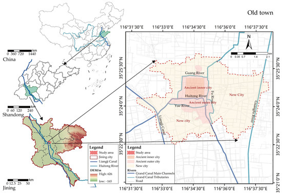
Figure 3.
Location of the study area.
The old town of Jining City includes two main channels of the canal: the ancient canal (Huitong River) and the modern canal (Liangji Canal). The Huitong River was built in the Yuan Dynasty (AD 1289), and during the same period, two tributaries of the Guang River and the Fu River were built to divert the Wen River and the Si River to the old town to replenish the water source of the Huitong River, and then, the water was diverted from north to south by the Huiyuan Gate in the old town [40]. The Grand Canal led to the rapid rise of Jining City, which gradually developed into a national commercial and trade center during the Ming and Qing dynasties and was known as the “Canal Capital”. From 1958 to 1961, due to the needs of shipping development, the Liangji Canal and the Guangfu River, which supplied water sources, were built within the city. Since then, the ancient and modern canals system of Jining City has been formed. Within the study area, the length of the Huitong River is about 5.95 km, which is closely related to the life of urban residents, and the length of the Liangji Canal is about 3.04 km, which is closely related to the production and transportation of the city. The two main channels of the canal and their first-class tributaries formed in different historical periods converge in the old town, which are closely integrated with the development of Jining City [40].
2.3. Data Sources and Data Processing
- (1)
- Information on resources in the old town, of which the data of 23 officially protected monuments and sites at all levels are derived from the list issued by the local government. The data information of 2 hydraulic engineering facilities, 2 scenic spots, and 32 parks and squares comes from the local government and on-site research records. There is a total of 59 resources in the old town.
- (2)
- The river and road data are obtained by cross-checking the road network obtained from the Open-Street Map open-source map (https://www.openstreetmap.org/, accessed on 27 August 2024), with AutoNavi Map and field research results. The data include the ancient and modern canals system, the existing road system, and the existing pedestrian spaces.
- (3)
- Administrative boundary data, obtained from the Resource and Environmental Science Data Center (https://www.resdc.cn/, accessed on 22 October 2023).
- (4)
- Population raster data, 100-m resolution, (obtained from WorldPop; https://hub.worldpop.org/geodata/summary?id=49730, accessed on 26 August 2024).
- (5)
- The land use data are derived from the third national land survey data provided by the Jining Municipal Government and are corrected against the land use map of urban development land in Jining City.
- (6)
- The data of public service points are derived from Bigemap v15.4.0.0 software, including six categories: science and education culture, tourist attractions, business and residence, life services, health care, and sports and fitness, and the access date is 22 August 2023.
- (7)
- The location data of community entrances were manually searched and drawn using Bigemap software, with a total of 352 places.
Data processing: For the land use data, since the study area is a high-density central urban area, it is divided according to the urban development land, and the third national land survey data provided by the government are combined with the map [41] of Jining City Master Plan (2014–2030) to reclassify the land use, and finally, the land use is divided into Residential land use; Administrative and public service land use; Commercial and business land use; Industrial land use; Logistics and warehouse land use; Public utilities land use; Green space and city square; Special land use; and Water, street, and transportation land use. The street land use is then divided into expressways, trunk roads, secondary roads, and branch roads according to the level of urban roads, and attention is paid to the trails that have been built in the urban areas, such as roads in parks, riverside paths, etc. Combined with the downloaded road data grading and map satellite imagery, each road grade is further subdivided into motorized lanes, non-motorized lanes, and sidewalks. The kernel density analysis was carried out on road lines and public service points, the Euclidean distance analysis was carried out on the river data, and the multi-ring buffer analysis was carried out on the resource data. The intersection of the road and the river is obtained by intersecting the existing road system with the ancient and modern canals system.
3. Results
3.1. Potential Route Research of the Grand Canal National Trails
3.1.1. Identification of the Source and Sink Points
- (1)
- Source and sink point
In this study, the ancient and modern canals system, which is composed of the main channels of the Huitong River and the Liangji Canal, as well as the tributaries of the Guang River and the Fu River, was selected and incorporated into the source and sink point system, which is the basis for the construction of the GCNTs. Two surviving hydraulic engineering facilities, such as the Huiyuan Gate, were selected as “function-related” resources, which are important witnesses of the canal’s water conservancy and transportation functions in the old town since the Yuan Dynasty. Twenty-three structures such as Dongda Temple were selected as “history-related” resources, which are cultural symbols that have gradually formed in the city since the Ming and Qing Dynasties due to the development and promotion of the canal; 32 parks and squares and two scenic spots in the urban area were selected as “activities-related” resources, which are outdoor public activity places closely related to residents’ lives that have been gradually built in the canal area of the old town since 1949.
Based on the above selection of the source and sink point system, 59 resources, 352 community entrances, and 132 road and canal intersections are used as the representation points of the above-selected source and sink point system, which are the starting and ending points of the link between the urban residents, the canals, and the resources. They are each other’s source and sink points in the analysis process, and their spatial distribution is shown in Figure 4.
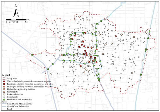
Figure 4.
Spatial distribution of the source and sink points.
- (2)
- Source and sink point connection
The goal of the GCNTs construction is to build the best “canal–resource–community” interconnection through the trails and establish the best paths between (a) canals and resources, (b) resources and resources, (c) canals and communities, and (d) resources and communities.
3.1.2. Resistance Surface Construction
- (1)
- Selection of resistance factors:
Based on the existing research results of the route selection of trails [27] in high-density urban areas and the actual situation of the old town of Jining City, at the spatial and social levels, this study identified six resistance factors from four aspects: land use categories, public service, convenient accessibility, and travel potential. Among them, the land use categories were divided into 11 categories of index factors according to the categories of urban development land. For the aspect of public service, road density and public service density were selected as the index factors. For the aspect of convenient accessibility, the distance from the canal and the distance from the resource were selected as the index factors. For the aspect of travel potential, population density was selected as the indicator factor (Table 1).

Table 1.
National trail resistance factor system.
- (2)
- Resistance value assignment:
The resistance value is relatively assigned according to the influence of various index factors on the intensity of urban residents’ walking and cycling activities, and the assignment range is between 1 and 500. At the spatial level, the higher the assignment of the land use categories, the lower the relative walking and cycling traversability, and the lower the assignment of the land use categories, the higher the relative pedestrians’ and cyclists’ traversability. For the service aspect, the higher the road density and public service density assignment, the worse the service for walking and cycling. Conversely, the lower the assignment, the better the service for walking and cycling. For the accessibility aspect, the higher the assignment of the area farther away from the canal and resources, the lower the accessibility. Conversely, the lower the assignment, the higher the accessibility. For the potential aspect, the lower the population density, the higher the assignment value, the smaller the travel potential. Conversely, the lower the assignment, the higher the potential.
In the construction of the comprehensive resistance surface, the actual conditions of walking and cycling in various categories of land use in high-density central urban areas are carefully considered, and the various pedestrian spaces in the urban area that have been built and used for many years but are not continuous are fully combined. The assignment of such land is reflected in the street land use, and it is subdivided into different assignment types according to whether it has a pedestrian or non-motorized transportation system, which reflects the traversability of different levels of road land in the real state.
- (3)
- Weight distribution of resistance factors:
The weights of the resistance factors were allocated according to the influence of each index factor relative to the intensity of urban residents’ walking and cycling activities. Based on the research by Geng et al. [23] on the construction and optimization of ecological networks in high-density central urban areas, the research by Hu et al. [42] on the construction of Wuhan ‘s ecological network, and the Delphi method conducted by 12 experts from design institutes and universities, the weight distribution of resistance factors was comprehensively judged. This study adopted a three-round Delphi method process, which organized experts to participate in the questionnaire scoring. In the first round, experts were invited to score the preliminary multi-level resistance factor system and provide suggestions for revision, which were used to refine the structure. In the second round, group mean scores and individual ratings were fed back to experts to promote reconsideration based on collective judgment, facilitating the formation of an initial consensus. In the third round, further feedback was provided to reach a consensus, and the average scores from this round were used as the basis for the relative importance of each factor. The entire process is shown in Figure 5.
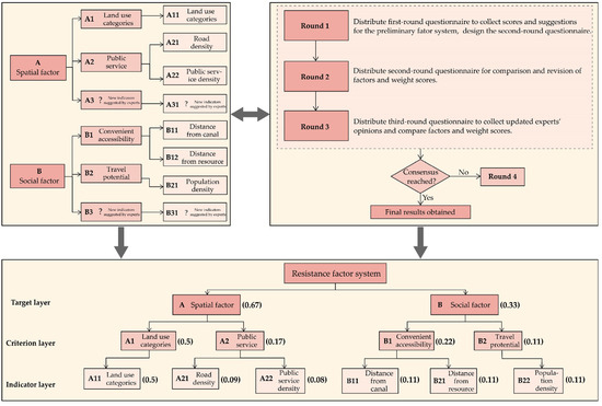
Figure 5.
Schematic diagram of the Delphi process for determining resistance factors and their weights.
- (4)
- Construct a comprehensive resistance surface:
Based on the above methods, the single-factor resistance surfaces are constructed. Then, the comprehensive resistance surface of the whole region is generated by superposition (Figure 6).
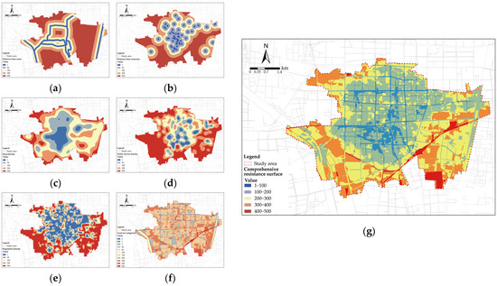
Figure 6.
Construction of the resistance surface. (a) Distance from the canal resistance surface. (b) Distance from the resource resistance surface. (c) Road density resistance surface. (d) Public service density resistance surface. (e) Population density resistance surface. (f) Land use categories resistance surface. (g) Comprehensive resistance surface.
3.1.3. Route Generation of Potential Trails
Based on the above analysis results, the minimum cost path between the source and sink points in the old town was fitted by the MCR model, including the minimum cost path between communities and canals (Figure 7a), the minimum cost path between resources and communities (Figure 7b), the minimum cost path between resources (Figure 7c), and the minimum cost path between resources and canals (Figure 7d). The least-costly paths were superimposed to form the routes of potential trails in the old town (Figure 7e).
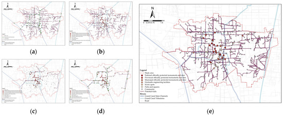
Figure 7.
Route generation of potential trails. (a) Route selection between communities and canals. (b) Route selection between resources and communities. (c) Route selection between resources. (d) Route selection between resources and canals. (e) Routes of potential trails.
3.2. Route Generation and Grading of the Grand Canal National Trails
3.2.1. Route Generation for the National Trails
The calculated route selection of potential trails reflects the possibility of the route selection in the suitable spaces of the old town, but the final route selection for construction needs to fully consider the actual availability of the corresponding spaces in the high-density central urban area. Therefore, the space syntax method was used to analyze and compare the integration degree of potential trails and existing roads in the old town (Figure 8). The higher the integration degree of potential trails, the higher the necessity of trail construction in this area. The higher the integration of existing roads, such as non-motorized lanes and sidewalks, the higher the actual availability of trails in this area. There are two important research results: (1) In the area of “high necessity–high availability”, the trail has a high correlation with the canal resources in this area, the conditions of available pedestrian spaces are good, and the trail construction can mainly be reconstructed on the basis of the original pedestrian spaces. (2) In the area of “high necessity–low availability”, the canal resources associated with the trail in this section have important connection significance and value, but there is no pedestrian spaces that can be directly used under the actual conditions. The trail should be selected and built on the basis of meeting the planning conditions of natural resources, water conservancy, transportation, and other relevant departments. By comprehensively judging the potential possibility of the trails and actual availability, the route selection and construction approach of the GCNTs were finally determined.
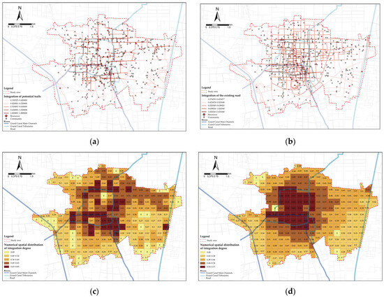
Figure 8.
Space syntax analysis of potential trails and existing roads. (a) Integration degree of potential trails. (b) Integration degree of existing roads. (c) Numerical spatial distribution of integration degree of potential trails. (d) Numerical spatial distribution of integration degree of existing roads.
The results show that the route selection of potential trails along the Huitong River, the Guang River, the Fu River, the Yue River, and the surrounding areas of the resources in the old town has a high degree of integration, and about 67% of the potential trails with an integration degree greater than 0.5 are concentrated in this area. Secondly, the integration degree of potential trails on both sides of the Guangfu River is relatively high, about 0.4. However, the integration degree of potential trails on both sides of the Liangji Canal is low, about 0.2, as shown in Figure 8a,c.
From the perspective of the integration degree of the existing roads, the integration degree of the existing roads in the area around the ancient canal system in the old town is relatively high, and about 91.7% of the existing roads with an integration degree greater than 0.5 are distributed in this area. However, the integration degree of the existing roads on both sides of the Guangfu River and Liangji Canal is relatively low, and the values are mainly distributed between 0.3 and 0.4, as shown in Figure 8b,d.
This characteristic reflects the important role of the ancient canal system composed of Huitong River, Guang River, and Fu River, as well as the modern canal system composed of Guangfu River and Liangji Canal, for resource connectivity and the importance of building trails along the canal. The existing road conditions on both sides of the Huitong River and the first-class tributaries of the Guang River and the Fu River are good, and the trend of route selection is high, so the roads in this area should be fully utilized or reconstructed as trails. However, the existing road conditions on both sides of the Guangfu River and the Liangji Canal are poor, and the internal roads in parks should be fully utilized as trails, or new roads should be built. Through the above methods, the route selection of potential trails is comprehensively interpreted and corrected, and finally, the overall route selection of the GCNTs within the old town is obtained, as shown in Figure 9.
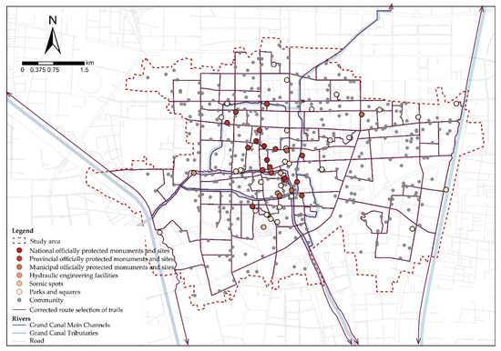
Figure 9.
Correcting the route selection of trails.
3.2.2. Route Grading of the National Trails
Based on the above research results and the relevant requirements of the Technical Standard [9], the trails around the main river channel composed of the Huitong River and the Liangji Canal are designated as the main route of the GCNTs, with a length of about 16.082 km; the trails around the first-level tributaries of the Guang River, Fu River, and Guangfu River are designated as the branch route of the GCNTs, with a length of about 20.178 km. A number of connection routes extend along the main route and branch route of the trail constructed in the surrounding area of the ancient and modern canals system, closely connecting the canal resources and community points into an integral network, forming a walking “loop” within the old town. It forms a network system with a total length of about 148.659 km and a spatial structure of “two lines, one ring, multiple branches, and multiple points”, which basically realizes the comprehensive coverage of the old town and the comprehensive connection between “canal–resource–community” (Figure 10).
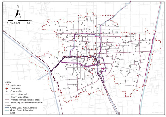
Figure 10.
“Main route–branch route–connection route” of the GCNTs system.
3.3. Benefit Evaluation of the Route Selection of the Grand Canal National Trails
The benefit evaluation is carried out in three aspects: (1) evaluate the relationship between the existing pedestrian spaces and the “canal–resource–community” in the city before the route selection, (2) evaluate the relationship between the generated routes and “canal–resource–community” after the route selection, and (3) compare the benefits before and after the route selection and explain the driving effect and benefits of route selection of the GCNTs on the old town as a whole.
The study used the fishing net tool to divide the study area of the old town, which has a compact spatial structure and a dense street network, into 285 grids according to 400 m × 400 m. Taking each grid as a spatial unit, firstly, the frequency of connection between urban residents and the “canal–resource” through the existing pedestrian spaces in the city was counted in the 285 grids starting from the entrances of each community before the route selection, and the characteristics of the overall spatial pattern before the route selection were described. Secondly, after the route selection, the 285 grids also took the entrances of each community as the starting point and counted the connection frequency of urban residents through the GCNTs to “canal–resource” and explained the characteristics of the overall spatial pattern after route selection. Finally, the connection frequency and spatial pattern characteristics before and after route selection were compared to illustrate the overall benefit of the route selection of the GCNTs.
The results show that, (1) before route selection, the grid with no correlation degree between all the communities in the study area and “canal–resource” through the existing pedestrian spaces in the city account for about 23.60% (connection frequency was 0), the grid with a low correlation degree accounts for about 37.19% (connection frequency was 1–2), the grid with a medium correlation degree accounts for about 18.74% (connection frequency was 3–4), and the grid with a high correlation degree accounts for about 20.47% (connection frequency ≥ 5). The spatial pattern is relatively fragmented, and the grids with a high correlation degree are mainly distributed in the historic area of Three Streets and Six Alleys along the Huitong River, the historic area of Ji’antai, and some areas on both sides of the Liangji Canal and the Guangfu River, while the grids with no or low correlation degree are mainly distributed in the ancient city, the urban life district, and the industrial district (Figure 11a).
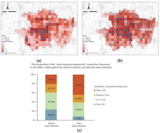
Figure 11.
Benefit evaluation of the benefits of the GCNTs network. (a) The connection frequency of the communities and the “canal–resource” through the existing pedestrian spaces in the city in the 400 m × 400 m grid before the route selection. (b) The connection frequency between the communities and the “canal–resource” through the GCNTs in the 400 m × 400 m grid after the route selection. (c) The comparison of the proportion of the “canal–resource–community” connection frequency in the 400 m × 400 m grid in the old town before and after the route selection.
(2) After route selection, the grid with no correlation degree between all the communities in the study area and “canal–resources” through the GCNTs accounts for about 7.98% (connection frequency is 0), the grid with a low correlation degree accounts for about 31.04% (connection frequency is 1–2), the grid with medium correlation accounts for about 16.89% (connection frequency is 3–4), and the grid with a high correlation degree accounts for about 44.09% (connection frequency ≥ 5). In addition to the historic area of Three Streets and Six Alleys along the Huitong River, the Ji’antai Historic area, and the surrounding areas of the Liangji Canal and the Guangfu River, the grid with high correlation also includes most of the ancient city area, urban life, and industrial districts surrounded by first-class tributaries such as the Guang River and the Fu River. Most of the grids with no or low correlation are located in areas that are far away from the route selection of the GCNTs (Figure 11b).
(3) Through the comparison of benefits before and after route selection, it can be found that the area with high correlation between “canal–resource–community” in the study area after route selection increased by 23.61% compared with that before route selection, and the area with no or low correlation decreased by 21.76% (Figure 11c). This change shows that the route selection of the GCNTs has significantly improved the connection between the communities, the canals, and related resources in the old town and transformed the originally relatively fragmented spatial pattern into a coherent and balanced overall spatial network. The main and branch channels of the ancient and modern canals system and the rich and diverse resources around them form a complete urban canal cultural narrative system after the connection of the GCNTs, which can systematically tell historical stories of the old town and the canal in the agricultural era, the industrial era, and the post-industrial era for urban residents and tourists. It will certainly play a significant role in the development of economic, social, and cultural tourism in the old town.
4. Discussion
4.1. Discussion on Research Methodology
(1) In terms of trail route generation, compared to the traditional MCR method, which only takes resources as the source and sink points, this study integrates the entrances and exits of communities in the old town into the source and sink system, thereby expanding the analytical dimension of exploring the minimum cost path of “canal–resource–community”. The results indicate that the route selection of GCNTs effectively connects 352 communities and 59 resource points within the old town, positively contributing to the spatial integration of the area.
When constructing the resistance surface, resistance factors that reflect the actual situation of high-density central urban areas were comprehensively selected from the two levels of spatial factors and social factors. The construction logic of resistance surfaces was enhanced from four aspects: diverse land use categories, convenient services, walking accessibility, and travel potential. Furthermore, the trail fully integrates various long-established yet fragmented pedestrian spaces, such as pedestrian spaces on municipal roads, in parks, squares, and various blocks. Based on existing road conditions, the potential trail was adjusted to align with areas of high integration (integration value > 0.5), resulting in a continuous trail network with a total length of approximately 148.659 km. The route selection methods better meet the GCNTs’ requirements for “Connectivity”, “Promotion”, and “Continuity” (Figure 12).
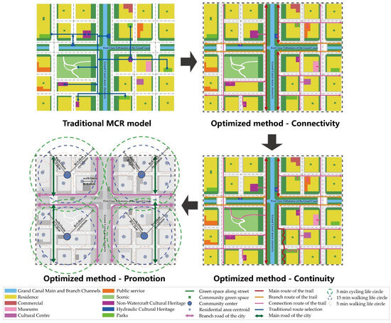
Figure 12.
Comparison of the effectiveness of traditional and optimized methods.
(2) In terms of trail route benefit evaluation, a comparison was conducted on the “canal–resource–community” connectivity before and after the route selection of GCNTs. The results show that the proportion of high correlation increased by 23.61% after the route selection, offering a more intuitive representation of the benefits of the GCNTs construction. This suggests that the GCNTs transform the originally fragmented spatial pattern into a more integrated and connected system, enhancing the interaction among internal nodes.
Therefore, the route selection methods proposed in this study demonstrate significant applicability and practical value in high-density central urban areas.
4.2. The Research Significance and Cultural Narrative Value of the Route Selection Study for the Grand Canal National Trails
Most of the cities rise and prosper because of the canal. In the long cycle of development of history, a deep and diverse canal culture has been born, with a rich tangible and intangible cultural heritage. However, from the perspective of urban development, during the period of rapid urbanization and incremental development, the disorderly expansion of cities has led to the fragmentation of cultural resources, resulting in the continuous loss of people’s historical memory of the ancient canal city. From the research perspective, existing studies have primarily concentrated on urban development [43,44], the preservation of individual cultural heritage [45,46], the ecological security pattern [47], environmental restoration [48], and evaluation [49]. There are, however, relatively few studies on the sustainable utilization of canal heritage, and it is challenging to demonstrate the relationship between the canal and community residents, cultural heritage, and parks and green spaces in this city known as the “Canal Old Town”. This study introduces a new research dimension, focusing on utilizing the Grand Canal National Trails as a link to emphasize the connection between the canal and the city, helping to address a relatively weak aspect in the existing research on Jining City.
The route selection of the GCNTs in the old town of Jining proposed in this study has established a high correlation between “canal–resource–community”, which has changed the current relatively fragmented spatial pattern for cultural cognition. The main and branch channels system of the ancient and modern canals and the surrounding various resources are connected into an overall spatial network, forming a canal cultural narrative path of “Beads on Long Vines”. The main canal channels such as the Huitong River and the Liangji Canal and the branch channels such as the Guang River and the Fu River, as well as the ancient hydraulic engineering facilities such as Huiyuan Gate, were explained to urban residents and tourists, and the historical and cultural stories of the canal system and the historical area such as the ancient city, the Three Streets and Six Lanes, the Ji’antai, and the historical nodes such as Taibai Tower and Dongda Temple were explained, so that people could experience the historical spatial pattern of the ancient canal city in an all-encompassing way, with the trail as a key aspect. At the same time, the route selection of the GCNTs in the old town of Jining also closely links the urban residential communities, parks and green spaces, and squares formed during the industrial and post-industrial development periods, forming a canal cultural narrative system of “Convergence of Tradition and Modernity”, so that the historical memory of the thousand-year-old canal old town can be restored and reconstructed in the city walk of urban residents’ daily life, with the trail as the vein. The GCNTs will play an important role in supporting and driving the cultural rejuvenation of the city (Figure 13).
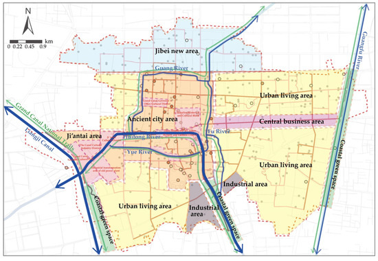
Figure 13.
The cultural narrative path and system of “two lines, one ring, multiple branches, and multiple points” of Jining Canal.
4.3. Limitations
- (1)
- In terms of resource selection, this study only included the national-, provincial-, municipal-, and county-level officially protected monuments and sites determined by the third national cultural relics census. There are still a large number of historical resources in the old town that have not been included in the national published list or historical resources that have disappeared at present but are of great significance to the inheritance of canal culture. These resources are undoubtedly important witnesses to the historical spatial pattern and canal culture of the old town. The connection between the GCNTs and these resources also has important relevance and driving value. In the future, comprehensive and in-depth research and statistics on such resources can further revise and enrich the conclusions of this study.
- (2)
- The factors influencing the route selection of national trails in high-density central urban areas are complex and diverse. Based on the overall characteristics of the old town of Jining City, this study emphasizes the scientific calculation and theoretical deduction of spatial factors such as land use categories and public service, as well as social factors such as travel potential, that affect the route selection. However, in addition, natural factors, policy factors, and human activities will also have an impact on the route selection of national trails [19]. In the actual construction work, the route selection methodology proposed in this study should be adjusted according to the characteristics of the natural environment, social conditions, and urban residents’ activities rules in different sections of the city, so as to better integrate with practice.
5. Conclusions
This study summarizes the theories and methods of scientific route selection for the GCNTs in high-density central urban areas with abundant natural and cultural resources, coupled “spatial–social” multiple factors and complex conditions of the built environment. The conclusions are as follows:
- (1)
- A theoretical framework for the route selection of the GCNTs, which is applicable to high-density central urban areas, is constructed from the three dimensions of “connectivity, continuity, and promotion”. In terms of “connectivity”, 23 officially protected monuments and sites at all levels, 2 hydraulic buildings, 2 scenic spots, 32 parks and squares, and 352 urban communities related to the canal but with fragmented spatial characteristics are closely connected by the ancient and modern canals as the main vein, realizing effective “multi-source connectivity” among “canal–resource–community”. In terms of “continuity”, a multi-level spatial network is constructed based on land use categories, public service, convenient accessibility, and travel potential, highlighting the historical and cultural characteristics of Jining’s old town while taking into account the realism and operability. In terms of “promotion”, it effectively responds to the multiple couplings of spatial structure, social functions, and residents’ needs in the complex urban environment. The spatial structure of “two lines, one ring, multiple branches, and multiple points” can provide urban residents and tourists with holistic, diverse, and continuous cultural and recreational services. The canal cultural narrative path of “Beads on Long Vines” and the cultural narrative system of “Convergence of Tradition and Modernity” can contribute significantly to the brand image and cultural revitalization of cities along the Grand Canal.
- (2)
- In response to the limited adaptability of traditional route selection methods in high-density central urban areas, this study proposes a “three sections, six steps” technical approach and methodology. The MCR model is optimized by incorporating community dimensions into the source and sink system and adding the consideration of social and spatial factors to the resistance surface construction. Additionally, the integration of space syntax enables the deep coupling of proposed trail routes with existing, fragmented pedestrian spaces. On this basis, optimal paths connecting “canal–resource–community” are identified, and a hierarchical trail system—"main route–branch route–connection route”—is established. This approach significantly enhances spatial coherence and connectivity within the old town, transforming a previously fragmented urban structure into an integrated network. It fully realizes the requirements of the GCNTs for connectivity, continuity, and promotion. The proposed methodology provides methodological support for the selection and construction of national trails in high-density central urban areas in six provinces, two centrally administered municipalities, 35 prefecture-level cities, and 150 districts and counties along the Grand Canal, as well as provide reference for the route selection for greenways, scenic byways, and other similar, related concepts.
Author Contributions
Conceptualization, X.X.; Methodology, Y.S. and X.X.; Software, Y.S.; Data curation, Y.S.; Writing—original draft preparation, Y.S.; Writing—review and editing, X.X. and N.L.; Visualization, Y.S.; Supervision, X.X. Project administration, N.L. All authors have read and agreed to the published version of the manuscript.
Funding
This work funded by the National Development and Reform Commission (NDRC) Major Project in Social Field: “Research on the Construction Paths of the Grand Canal National Trail” (202306).
Data Availability Statement
The data that support the findings of this study are available from the author upon reasonable request.
Acknowledgments
We would like to thank the China Agricultural University team members: Wen Wang and Yixian Li, and China Construction Engineering Design & Research Institute: Xiaoyan Zhang, Jia Guo, Meng Zhang, Jing Zhang, Lu Li, Haoke Mu, and Dawei Jiang for their help.
Conflicts of Interest
Author Ning Lyu was employed by the company China Construction Engineering Design & Research Institute Co., Ltd. The remaining authors declare that the research was conducted in the absence of any commercial or financial relationships that could be construed as a potential conflict of interest.
Note
| 1 | Three vertical and four horizontal systems: build “three verticals” along the Taihang Mountain and the Beijing–Hangzhou Grand Canal, Xi’an–Chengdu, and Qinghai–Tibet Highway; build “four horizontals” along the Silk Road, 318 National Highway, the Yangtze River, and the Yellow River; and build a spatial layout of “three verticals and four horizontals” for outdoor sports. |
References
- National Park Service. National Scenic and Historic Trails—FAQs. Available online: https://www.nps.gov/subjects/nationaltrailssystem/faqs.htm (accessed on 9 December 2024).
- National Park Service. About the System—National Trails System. Available online: https://www.nps.gov/subjects/nationaltrailssystem/what-we-do.htm (accessed on 9 December 2024).
- National Park Service. National Trails System Act Legislation—National Trails System. Available online: https://www.nps.gov/subjects/nationaltrailssystem/national-trails-system-act-legislation.htm (accessed on 9 December 2024).
- Chen, X.; Ban, Y.; Zhang, Y.; Chen, Y.; Wang, K.; Zhang, W.; Zhang, N.; Zhang, L.; Li, K.; Jia, J.; et al. National Forest Trail; China Forestry Publishing House: Beijing, China, 2016; Chapter 3; pp. 144–253. [Google Scholar]
- Godtman Kling, K.; Fredman, P.; Wall-Reinius, S. Trails for tourism and outdoor recreation: A systematic literature review. Tour. Int. Inter-Discip. J. 2017, 65, 488–508. [Google Scholar]
- Yahel, H.; Katoshevski-Cavari, R.; Galilee, E. National hiking trails: Regu-larization, statutory planning, and legislation. Land Use Policy 2021, 108, 105586. [Google Scholar] [CrossRef]
- General Office of the Central Committee of the Communist Party of China; General Office of the State Council of the People’s Republic of China. Opinions on Building a Higher-Level National Fitness Public Service System. Available online: https://www.gov.cn/gongbao/content/2022/content_5683839.htm (accessed on 9 December 2024).
- Chinese National Development and Reform Commission. The Grand Canal National Trail Construction Implementation Plan; Chinese National Development and Reform Commission: Beijing, China, 2024.
- T/CSUS 90-2025; Technical Standard for the Construction of the Grand Canal National Trail. Chinese Society for Urban Studies: Beijing, China, 2025. Available online: https://www.chinasus.org/index.php?c=content&a=show&id=1268 (accessed on 3 March 2025).
- Zhang, S.; Yu, W. Canal Heritage Tourism Utilization Models: Experience and Inspirations from the Grand Canal (Beijing Section). Land 2024, 13, 860. [Google Scholar] [CrossRef]
- Knaapen, J.P.; Scheffer, M.; Harms, B. Estimating habitat isolation in landscape planning. Landsc. Urban Plan. 1992, 23, 1–16. [Google Scholar] [CrossRef]
- Yu, K. Security patterns and surface model in landscape ecological planning. Landsc. Urban Plan 1996, 36, 1–17. [Google Scholar] [CrossRef]
- Chiou, C.R.; Tsai, W.L.; Leung, Y.F. A GIS-dynamic segmentation approach to planning travel routes on forest trail networks in Central Taiwan. Landsc. Urban Plan. 2010, 97, 221–228. [Google Scholar] [CrossRef]
- Tomczyk, A.M.; Ewertowski, M. Planning of recreational trails in protected areas: Application of regression tree analysis and geographic information systems. Appl. Geogr. 2013, 40, 129–139. [Google Scholar] [CrossRef]
- Huang, Y.; Shen, S.; Hu, W.; Li, Y.; Li, G. Construction of Cultural Heritage Tourism Corridor for the Dissemination of Historical Culture: A Case Study of Typical Mountainous Multi-Ethnic Area in China. Land 2022, 12, 138. [Google Scholar] [CrossRef]
- Li, H. Western Sichuan Plateau Greenway Trails System Planning Method Based on MCR Model. Urban Dev. Stud. 2018, 25, 58–64. [Google Scholar] [CrossRef]
- Zhou, L.; Zhao, Y.; Zhu, C.; Shi, C. Route Selection for Scenic Byways in Karst Areas Based on the Minimum Cumulative Resistance Model: A Case Study of the Nanpan-Beipan River Basin, China. Ecol. Indic. 2024, 163, 112093. [Google Scholar] [CrossRef]
- Li, H.; Zhang, T.; Cao, X.; Yao, L. Active Utilization of Linear Cultural Heritage Based on Regional Ecological Security Pattern along the Straight Road (Zhidao) of the Qin Dynasty in Shaanxi Province, China. Land 2023, 12, 1361. [Google Scholar] [CrossRef]
- Yue, F.; Li, X.; Huang, Q.; Li, D. A Framework for the Construction of a Heritage Corridor System: A Case Study of the Shu Road in China. Remote Sens. 2023, 15, 4650. [Google Scholar] [CrossRef]
- Jeong, D.; Kim, M.; Song, K.; Lee, J. Planning a Green Infrastructure Network to Integrate Potential Evacuation Routes and the Urban Green Space in a Coastal City: The Case Study of Haeundae District, Busan, South Korea. Sci. Total Environ. 2021, 761, 143179. [Google Scholar] [CrossRef] [PubMed]
- Zhang, J.; Zhu, H.; Zhang, P.; Song, Y.; Zhang, Y.; Li, Y.; Rong, T.; Liu, Z.; Yang, D.; Lou, Y. Construction of GI Network Based on MSPA and PLUS Model in the Main Urban Area of Zhengzhou: A Case Study. Front. Environ. Sci. 2022, 10, 878656. [Google Scholar] [CrossRef]
- Zheng, D.; Zhou, X.; He, Y.; Jiang, W. The Research on Urban Greenway Fineness Route Selection Technology Based on Multivariate Big Data and Network Model: A Cace Study of Wuhan Greenways. Mod. Urban Res. 2023, 8, 113–118. [Google Scholar] [CrossRef]
- Geng, J.; Yu, K.; Sun, M.; Xie, Z.; Huang, R.; Wang, Y.; Zhao, Q.; Liu, J. Construction and Optimisation of Ecological Networks in High-Density Central Urban Areas: The Case of Fuzhou City, China. Remote Sens. 2023, 15, 5666. [Google Scholar] [CrossRef]
- Zhou, X.; Tang, Y.; Su, J. Heritage Corridor Routing Method from Historic Urban Landscape and Digital Footprint Perspectives--The Case of Historical Urban Area in Nanjing, China. Landsc. Archit. Front. 2023, 11, 11. [Google Scholar] [CrossRef]
- Lu, J.; Wu, X. Research on Urban Greenway Alignment Selection Based on Multisource Data. Sustainability 2022, 14, 12382. [Google Scholar] [CrossRef]
- Chen, Z.; Liu, S.; Liao, W.; Zhang, J. Construction of Security Pattern for Historical Districts in Cultural Landscape Based on MCR Model: A Case Study of Chaozong Street, Changsha City. Sustainability 2023, 15, 10619. [Google Scholar] [CrossRef]
- Wang, Q.; Yang, C.; Wang, J.; Tan, L. Tourism in Historic Urban Areas: Construction of Cultural Heritage Corridor Based on Minimum Cumulative Resistance and Gravity Model—A Case Study of Tianjin, China. Buildings 2024, 14, 2144. [Google Scholar] [CrossRef]
- Vizmpa, C.; Botzoris, G.; Lemonakis, P.; Galanis, A. Micromobility in Urban Trail Paths: Expanding and Strengthening the Planning of 15-Minute Cities. Land 2023, 12, 2181. [Google Scholar] [CrossRef]
- Kolkos, G.; Kantartzis, A.; Stergiadou, A.; Arabatzis, G. Development of Semi-Mountainous and Mountainous Areas: Design of Trail Paths, Optimal Spatial Distribution of Trail Facilities, and Trail Ranking via MCDM-VIKOR Method. Sustainability 2024, 16, 9966. [Google Scholar] [CrossRef]
- Raichel, N.R.; Yahel, H. Planning Challenges and Opportunities in the Conservation of National Trails: The Case of the Israel National Trail. Land 2024, 13, 1449. [Google Scholar] [CrossRef]
- Department for Environment, Food & Rural Affairs. National Trails Management Standards. GOV.UK; 27 February 2024. Available online: https://www.gov.uk/government/publications/national-trails-management-standards/national-trails-management-standards (accessed on 15 April 2025).
- Ye, H.; Yang, Z.; Xu, X. Ecological Corridors Analysis Based on MSPA and MCR Model—A Case Study of the Tomur World Natural Heritage Region. Sustainability 2020, 12, 959. [Google Scholar] [CrossRef]
- Hillier, B. Space is the Machine: A Configurational Theory of Architecture; Cambridge University Press: Cambridge, UK, 1996. [Google Scholar]
- Liu, P.; Xiao, X.; Zhang, J.; Wu, R.; Zhang, H. Spatial Configuration and Online Attention: A Space Syntax Perspective. Sustainability 2018, 10, 221. [Google Scholar] [CrossRef]
- Lebendiger, Y.; Lerman, Y. Applying space syntax for surface rapid transit planning. Transp. Res. Part A Policy Pract. 2019, 128, 59–72. [Google Scholar] [CrossRef]
- Huang, B.; Chiou, S.; Li, W. Accessibility and Street Network Characteristics of Urban Public Facility Spaces: Equity Research on Parks in Fuzhou City Based on GIS and Space Syntax Model. Sustainability 2020, 12, 3618. [Google Scholar] [CrossRef]
- Li, Y.; Xiao, L.; Ye, Y.; Xu, W.; Law, A. Understanding tourist space at a historic site through space syntax analysis: The case of Gulangyu, China. Tour. Manag. 2016, 52, 30–43. [Google Scholar] [CrossRef]
- Qian, Z.; Liu, Q.; Huang, D. Three Scales and Planning Trends of 15-Minute Life Circle. Int. J. Urban Plan. 2022, 37, 63–70. [Google Scholar] [CrossRef]
- Staricco, L. 15-, 10-or 5-minute city? A focus on accessibility to services in Turin, Italy. J. Urban Mobil. 2022, 2, 100030. [Google Scholar] [CrossRef]
- Liu, Y.; Zhang, Z.; Gao, J.; Feng, G.; He, W.; Zhao, M.; Liu, G.; Xu, Q.; Zhang, Y.; Duan, C.; et al. The Canal Culture of Jining; China Literature and History Publishing House: Beijing, China, 2001; pp. 7+38. [Google Scholar]
- Jining Municipal Bureau of Natural Resources and Planning. Comprehensive Urban Planning of Jining City (2014–2030); Jining Municipal Government: Jining, China, 2022. Available online: https://www.jining.gov.cn/art/2022/11/29/art_74158_2822681.html (accessed on 3 September 2024).
- Hu, C.; Wang, Z.; Wang, Y.; Sun, D.; Zhang, J. Combining MSPA-MCR Model to Evaluate the Ecological Network in Wuhan, China. Land 2022, 11, 213. [Google Scholar] [CrossRef]
- Li, F.; Liu, X.; Hu, D.; Wang, R.; Yang, W.; Li, D.; Zhao, D. Measurement indicators and an evaluation approach for assessing urban sustainable development: A case study for China’s Jining City. Landsc. Urban Plan. 2009, 90, 134–142. [Google Scholar] [CrossRef]
- Ma, H.; Wang, Q.; Zhang, Y.; Hussain, M.B.; Xu, Y.; Tian, S.; Yuan, X.; Ma, Q.; Yuan, R.; Jia, Y. Research on sustainable development evaluation and improvement path of resource-based cities based on coupling of emergy and system dynamics. Environ. Dev. Sustain. 2023, 26, 5959–6006. [Google Scholar] [CrossRef]
- Zhang, X. Remolding the Economic Value of the Cultural Heritage of Jining Iron Pagoda Temple. IOP Conf. Ser. Earth Environ. Sci. 2020, 531, 012015. [Google Scholar] [CrossRef]
- Yao, Z.; Zhang, Y.; Chen, N.; Pang, Y. Space-inclusive Governance Strategy and Design Approach of the Grand Canal National Cultural Park in Jining and Zaozhuang. Urban Reg. Plan. 2023, 8, 31–40. [Google Scholar] [CrossRef]
- Zhou, Y.; Chang, J.; Chen, Z.; Zhou, S.; Zheng, G. Construction of Ecological Security Pattern Based on Ecological Sensitivity Assessment in Jining City, China. Pol. J. Environ. Stud. 2022, 31, 5383–5404. [Google Scholar] [CrossRef]
- Zheng, X.; Wang, F. Construction of an adaptive river-based recreational network for urban river restoration: A case study of Rencheng District, Jining City, China. J. Clean. Prod. 2022, 374, 133985. [Google Scholar] [CrossRef]
- Wang, Z.; Ma, C.; Zhang, Y.; Hu, B.; Xu, S.; Dai, Z. Assessment of urban flooding vulnerability based on AHP-PSR model: A case study in Jining City, China. Geocarto Int. 2023, 38, 2252777. [Google Scholar] [CrossRef]
Disclaimer/Publisher’s Note: The statements, opinions and data contained in all publications are solely those of the individual author(s) and contributor(s) and not of MDPI and/or the editor(s). MDPI and/or the editor(s) disclaim responsibility for any injury to people or property resulting from any ideas, methods, instructions or products referred to in the content. |
© 2025 by the authors. Licensee MDPI, Basel, Switzerland. This article is an open access article distributed under the terms and conditions of the Creative Commons Attribution (CC BY) license (https://creativecommons.org/licenses/by/4.0/).