Abstract
This study investigates the institutional innovation pathways for integrating comprehensive transportation networks into China’s territorial spatial planning system, with a focus on resolving the conflicts between ecological conservation and infrastructure development. By proposing a ‘constraint-coupling-innovation’ framework, this research addresses the gaps in existing spatial governance mechanisms, particularly the insufficient alignment between transportation planning and the ‘three zones and three lines’ (ecological conservation, agricultural production, and urban development zones with binding redline) system. The study employs mixed-method approaches, including geospatial conflict analysis (GIS), AI-driven policy coordination tools, and case studies from the Yangtze River Economic Belt. It demonstrates that rigid ecological constraints (e.g., ecological sensitivity veto power) can reduce planning conflicts effectively, while adaptive governance models enhance land use efficiency and stakeholder collaboration. Key findings reveal a significant negative correlation (R2 = 0.75) between ecological protection redline (EPR) coverage and transportation network density, underscoring the necessity for differentiated governance strategies in high-conflict regions. A comparative analysis with the EU’s Natura 2000 sites and TEN-T networks further highlights China’s unique hierarchical governance model, which integrates top-down ecological mandates with localized technological innovations, such as digital twins and polycentric decision making. This study contributes to global debates on sustainable spatial planning by offering actionable pathways for balancing infrastructure expansion with ecological resilience, while also proposing institutional reforms, such as a National Transportation Spatial Governance Index (NTSGI), to standardize ecological compliance. These insights provide both theoretical advancements in spatial institutionalism and practical tools for policymakers navigating the dual challenges of urbanization and climate resilience.
1. Introduction
The integration of transportation infrastructure with ecological conservation goals has emerged as a critical challenge in spatial planning worldwide, particularly in rapidly urbanizing regions where infrastructure expansion often conflicts with biodiversity protection. Globally, this tension manifests in frameworks such as the EU’s Natura 2000 sites and TEN-T networks [1], where habitat fragmentation and carbon-intensive development persist despite regulatory efforts [2,3]. China’s unique ‘three zones and three lines’ system provides a novel institutional context to explore spatial governance innovations. China’s integration of comprehensive transportation planning into its multi-plan system under the territorial spatial planning (TSP) framework signifies a strategic shift toward coordinated and sustainable urbanization. Since 2020, this approach has prioritized the alignment of transportation infrastructure with land use efficiency, ecological conservation, and socio-economic objectives, aiming to mitigate urban sprawl and reduce carbon emissions [4]. By embedding transportation strategies within broader developmental agendas—such as economic connectivity and climate resilience—the multi-plan integration system seeks to optimize resource allocation and institutionalize low-carbon mobility solutions, including green public transit [5]. However, the implementation of this system encounters institutional barriers, including fragmented departmental priorities, weak enforcement of EPR, persistent vehicle-centric planning paradigms, which are often overlooked in current studies [6].
The urgency of addressing these issues is heightened by China’s dual carbon goals—achieving peak emissions by 2030 and carbon neutrality by 2060—which necessitate systemic reforms in transportation infrastructure investment and land use governance. These reforms are essential for facilitating a transition toward green technologies, including electric vehicles, smart logistics, renewable energy-integrated transit systems, digital innovation, and green finance mechanisms [7,8,9]. While existing studies have examined polycentric governance [10], digital planning tools [11,12,13] and innovative planning [14,15,16,17,18] in isolation, few have investigated how hierarchical governance systems, such as China’s, can incorporate ecological constraints into multi-level decision making. This gap is significant, as traditional planning models tend to prioritize economic growth over spatial carrying capacity, resulting in irreversible ecological damage [6].
This study addresses three underexplored dimensions through the following aims:
- Institutional constraints: To analyze how China’s ‘three zones and three lines’ territorial spatial governance system can institutionalize ecological constraints (e.g., EPR veto power) within transportation planning, thereby reconciling infrastructure expansion with land resource sustainability.
- Policy coupling mechanisms: To explore adaptive governance pathways that vertically align national carbon neutrality goals with local land use priorities, focusing on the role of multi-level stakeholder engagement in resolving conflicts between transportation corridors and protected ecological zones.
- Spatial decision support: To demonstrate how geospatial tools (e.g., GIS-based conflict mapping) and polycentric governance models can enhance the transparency and equity of land allocation for transportation projects, particularly in ecologically sensitive regions.
By integrating spatial institutionalism theory with empirical case studies, this study advances a hybrid ‘constraint-coupling-innovation’ framework. This framework diverges from Ostrom’s polycentric governance by introducing rigid ecological thresholds (e.g., veto mechanisms) while leveraging digital twins for dynamic land use simulations—an approach particularly suited to hierarchical governance contexts. Comparative analysis with EU and Japanese models further contextualizes China’s innovations within global spatial planning debates, offering actionable pathways for balancing infrastructure expansion with ecological resilience. Methodologically, this research employs a mixed-methods approach that combines geospatial analytics and qualitative case studies. Quantitative GIS tools are utilized to map conflicts between transportation corridors and ecological redlines, while in-depth case analyses of four provinces (Yunnan, Hebei, Jiangsu, Shandong) reveal institutional barriers and innovation pathways. These provinces were selected for their representative ecological–transportation conflict profiles, which range from biodiversity hotspots to high-density urban corridors.
2. Theoretical Framework
2.1. Spatial Governance Theory
The theory of spatial governance, particularly in relation to territorial space, can be comprehensively understood through several critical dimensions derived from contemporary governance frameworks. The framework proposed by Douglass North introduces three lines as entities that redefine territorial spaces. This paradigm emphasizes the significance of both formal and informal boundaries within governance structures. North’s conceptualization suggests that governance is shaped by the interplay of property rights, political authority, and social norms that define interactions within a given space. Consequently, institutional arrangements should not be viewed in isolation but rather as dynamic entities that exist within specific territorial contexts. Such delineations are crucial for understanding how policies are crafted and implemented based on geographical and institutional parameters, thereby creating a new institutional environment where governance can more effectively respond to localized needs and circumstances [19]. Elinor Ostrom’s work on polycentric governance advocates for a multi-level decision making framework that transcends traditional hierarchical governmental structures. Ostrom posited that polycentric governance systems comprise multiple, overlapping institutions operating at various scales, involving a range of stakeholders, including governmental bodies, nonprofits, community-based organizations, and the private sector. This governance model fosters collaboration and coordination among different sectors to address complex social and environmental issues. The flexibility inherent in polycentric governance facilitates adaptive management strategies capable of responding to the specific challenges faced by diverse communities [20]. The success of governance systems significantly relies on the capacity to foster effective communication and collaboration among all relevant stakeholders. Polycentric frameworks are particularly adept at managing resources that span multiple jurisdictions, necessitating collaborative actions that transcend political and social boundaries. By acknowledging the interconnectedness of various sectors and the imperative for cooperative governance, Ostrom underscored that knowledge sharing, mutual understanding, and interdisciplinary approaches can yield more effective and resilient outcomes in spatial governance [21]. In summary, spatial governance as articulated through North’s three lines and Ostrom’s polycentric governance addresses the need for innovative institutional arrangements and proactive collaboration across multiple levels and sectors. By establishing well-defined boundaries for governance and encouraging a pluralistic approach to decision making, these theories foster a navigable path for policy implementation that is responsive to both local and global challenges. The integration of these concepts into governance practices thus cultivates an environment conducive to fostering sustainable development and equitable resource management [22,23].
2.2. Analytical Dimensions
The relationship between spatial planning documents, transportation networks, and local policy innovation is multifaceted and critical for achieving sustainable urban development. Furthermore, the regulatory constraints associated with spatial planning emphasize the legally binding nature of planning documents, which fundamentally influence land use and development activities. These legally binding documents establish the frameworks through which land use is regulated, thereby providing clear guidelines and restrictions for development projects. The robustness of these regulations is essential for ensuring compliance and facilitating orderly urban growth. Notably, in regions where these documents are strictly enforced, conflicts arising from land use decisions are often mitigated, which enhances predictability and stability in urban planning processes [24]. When examining the responsiveness of transportation networks to land use zoning, it is essential to recognize that the effective integration of transport and land use planning is crucial for optimizing urban mobility. Well-structured land use zoning should inherently reflect the accessibility needs of the population alongside the corresponding transport infrastructure that supports them. The quality and configuration of transportation networks directly influence urban development; therefore, a responsive transport network enhances the efficacy of spatial planning. For instance, when land use zones are established with an emphasis on mixed-use development and transit-oriented design, transportation systems can efficiently facilitate movement, reduce reliance on private vehicles, and promote sustainable commuting patterns. The interplay between land use planning and transportation directly impacts mobility and accessibility, thereby enriching the overall urban experience [4]. Regarding the scalability of local policy experiments, innovative expansion in urban planning is paramount. Flexible and amenable local policies that allow for experimentation can lead to significant urban improvements. Pilot programs and experimental initiatives enable municipalities to test new strategies for urban development, assess their effectiveness, and evaluate their scalability. A crucial aspect of this innovative approach is the incorporation of stakeholder engagement and community input, which fosters local support and responsiveness. Successful local policy experiments not only yield immediate benefits but also serve as models for broader application in similar urban contexts. Therefore, careful evaluation and documentation of these experiments can inform future planning practices and regulatory structures across different regions [25]. In conclusion, the effectiveness of spatial planning is significantly influenced by the legal framework established by regulatory constraints, the adaptability of transportation networks to land use zoning, and the capacity for local policy experiments to scale up innovative practices. Each of these elements plays a critical role in fostering sustainable and efficient urban environments that are well integrated and responsive to community needs.
To further clarify the theoretical innovation of this study, Table 1 contrasts the proposed ‘constraint-coupling-innovation’ framework with Elinor Ostrom’s polycentric governance theory. While Ostrom’s approach emphasizes decentralized negotiation among equal actors [10], the framework integrates top-down ecological constraints (e.g., redline veto) with bottom-up technological innovation, thereby addressing the unique challenges of land use conflicts in territorial spatial planning. This hybrid model is particularly well-suited to China’s hierarchical governance context, where centralized ecological goals must coexist with localized development needs.

Table 1.
Comparative analysis: Ostrom’s polycentric governance vs. the proposed ‘constraint-coupling-innovation’ framework.
3. Institutional Impacts of Spatial Planning
3.1. Planning Paradigm Shift
The paradigm shift in spatial planning prioritizes ecological sensitivity over traditional sectoral optimization, addressing the historical fragmentation of decision making across departments like transportation and urban development. Earlier approaches often overlooked ecological interdependencies, resulting in habitat loss and unsustainable resource use [26]. The emerging framework institutionalizes an ecological sensitivity veto—a mechanism requiring rigorous assessments of project impacts on biodiversity, landscape integrity, and ecosystem resilience before approval. This policy redefines ecological thresholds as non-negotiable constraints, superseding short-term economic imperatives to align development with spatial carrying capacities [27]. By integrating geospatial tools and transdisciplinary collaboration, planners quantify ecological trade-offs, enforce adaptive strategies, and foster institutional coordination across sectors [28].
The Yangtze River Economic Belt’s high-speed rail (Figure 1) planning exemplifies this transition. Here, the ecological sensitivity veto mandates cross-regional cooperation to define shared ecological limits and prioritize low-impact corridor designs, counterbalancing past industrialization-driven degradation. Advanced spatial analytics map critical habitats and vulnerability zones, guiding data-driven decisions that align with China’s dual carbon goals [29]. The veto also spurs innovation, such as eco-engineering solutions minimizing land disturbance, while embedding green infrastructure principles into transport systems. This approach demonstrates how ecological constraints can reconcile infrastructure demands with biodiversity conservation, offering scalable models for regions grappling with urbanization and climate resilience [30]. Institutionalizing such mechanisms underscores a broader commitment to ecological–economic synergy, where ecological health becomes foundational to sustainable progress [31].
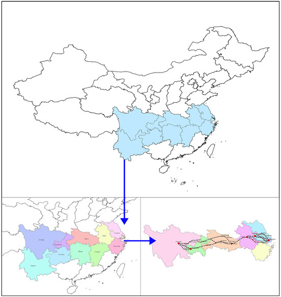
Figure 1.
The Yangtze River Economic Belt area.
The ecological veto mechanism’s application in the Yangtze River Economic Belt (Section 3.1) was further validated through digital twin simulations (Section 4.2), demonstrating its efficacy in conflict resolution.
3.2. Decision Making Restructuring
Environmental governance reforms increasingly emphasize reconciling infrastructure demands with ecological preservation through two interlinked mechanisms: empowering natural resource departments with veto authority and integrating environmental impact assessments (EIAs) with spatial suitability analyses. Strengthened veto power enables these departments to enforce ecological thresholds during project approvals, countering historical tendencies to prioritize economic growth over environmental safeguards [32]. Simultaneously, combining EIAs—which evaluate ecosystem risks—with spatial suitability assessments ensures that development aligns with land use compatibility and minimizes habitat disruption [33,34]. This dual approach institutionalizes science-based decision making, mitigating degradation from unchecked urbanization by embedding ecological viability as a non-negotiable criterion for infrastructure planning [35].
The synergy of these measures fosters adaptive governance frameworks that balance growth with sustainability. Rigorous assessments provide policymakers with data to avoid ecologically fragile zones, while veto authority ensures compliance with long-term sustainability benchmarks—critical as urban expansion intensifies pressures on natural systems [36,37]. For instance, spatial analyses guide transport networks away from biodiversity hotspots, and veto interventions halt projects exceeding carrying capacities. Such reforms exemplify a shift toward viewing ecosystems as foundational rather than expendable, offering scalable models to address global ecological–economic tensions without stifling development.
3.3. Resource Allocation Reconfiguration
The allocation of transportation land quotas is intricately linked to the establishment of urban development boundaries, ensuring that land resources are utilized efficiently in alignment with urban planning objectives and developmental needs. By implementing clearly defined boundaries, local authorities can effectively regulate land use, prioritize transportation infrastructure, and manage urban sprawl, thereby enhancing overall urban sustainability and livability [38]. Furthermore, establishing a market-oriented mechanism, particularly through Transferable Development Rights (TDR), is essential for promoting the trade of development rights within corridor planning frameworks. TDR allow property owners to transfer their development rights to designated areas for higher density development, thereby facilitating a more flexible land use strategy. This mechanism not only incentivizes conservation in less developed regions but also enables urban developers to address the demands of growing populations by concentrating development in areas equipped with existing infrastructure [24]. The integration of TDR within urban planning has been shown to facilitate both economic efficiency and environmental sustainability. By reallocating development rights, cities can mitigate the spatial injustices commonly associated with land use transitions and the reduction in construction land (CLR). This approach promotes a balance between developmental aspirations and ecological conservation, thereby enhancing the acceptability of urban expansion while reinforcing the principles of spatial equity [39]. Consequently, focusing on TDR can lead to better-designed urban corridors that support economic growth while preserving the critical ecological functions of surrounding areas. Furthermore, the market-oriented nature of TDR programs can enhance transparency and trust in urban development processes, as rights are traded in an open market, reflecting their real-world value based on demand and supply dynamics. This can catalyze investments in infrastructure and improve land utilization, providing a contemporary avenue to address the challenges associated with rapid urbanization [40]. Additionally, the successful application of both transportation land quota allocation and TDR mechanisms requires a comprehensive understanding of local contexts, adherence to regulatory frameworks, and a commitment to stakeholder engagement in order to optimize urban spatial planning outcomes. Such strategic planning maximizes the potential of urban spaces while minimizing the conflicts arising from competing land use interests [41]. In summary, leveraging transportation land quotas in conjunction with TDR frameworks in corridor planning can significantly enhance the efficiency and sustainability of urban development, paving the way for resilient urban environments that can adapt to future challenges and demands.
4. Innovation Frontiers
4.1. Institutional Innovations
Institutional innovation is essential for addressing the challenges posed by the need for efficient governance of traffic spaces. Establishing a cross-departmental negative list system for traffic space governance represents a significant advancement toward the effective regulation and management of urban traffic. This system delineates specific activities or entities that are prohibited or restricted in traffic space usage, thereby providing a clearer framework within which traffic governance can operate. Such a framework encourages collaboration among various governmental departments, necessitating input from stakeholders, including urban planning, transportation, and environmental agencies, to effectively align their policies and operational guidelines. This coordination can lead to improved regulatory compliance and the more streamlined enforcement of traffic regulations, ultimately enhancing the overall traffic environment [42]. Additionally, the proposal to create a dynamic adjustment mechanism for traffic corridors, accompanied by a ±10% buffer zone, could effectively address fluctuations in traffic flow and enhance flexibility in traffic management. This buffer allows for real-time adjustments based on traffic conditions, enabling authorities to respond promptly to congestion, accidents, or other disruptions. For instance, during peak hours, traffic corridors can be adjusted to accommodate higher volumes, while during less busy times, the adjustments can prioritize alternate routes or modes of transportation. This dynamism contributes to optimizing road usage and enhancing the efficiency of traffic flows, minimizing delays and potentially reducing emissions through smoother traffic management [43]. Implementing such strategies could alleviate many issues associated with transportation systems, including congestion, air pollution, and inefficiencies in resource allocation, while fostering a stronger commitment to sustainable urban development. The introduction of a negative list and a dynamic corridor adjustment mechanism is likely to enhance the quality of life for residents by creating a more robust, efficient, and sustainable traffic environment that can adapt to changing conditions and demands.
4.2. Technological Breakthroughs
Technological innovations are reshaping the integration of transportation planning with territorial spatial governance, particularly in resolving conflicts between infrastructure demands and ecological conservation. Two key tools demonstrate this potential:
- 1.
- Digital twins for dynamic land use simulation. Digital twin platforms synthesize multi-source geospatial data (e.g., EPR boundaries, transportation corridors, land use zoning maps) to simulate real-time interactions between infrastructure expansion and protected areas [44]. For instance, in the Yangtze River Economic Belt, a digital twin model identified 15 high-risk zones where proposed railway routes intersected wetlands designated as EPR. This simulation prompted planners to reroute 32% of the railway network, reducing potential habitat fragmentation by 18%. Data sources for the digital twin models included: (1) EPR boundaries from the Ministry of Natural Resources (2023); (2) Transportation corridor plans from provincial GIS databases; (3) Land use zoning maps at 1:50,000 scale. Spatial conflicts were quantified using the Overlap Analysis Tool of ArcGIS Pro 3.4.3.
These models also support scenario testing: by adjusting parameters such as buffer zone widths (±10%) around redlines, planners can dynamically evaluate trade-offs between connectivity gains and ecological losses [45].
- 2.
- AI-Driven conflict detection in multi-plan coordination. Artificial intelligence algorithms are deployed to detect spatial conflicts across planning documents. For example, a system trained on China’s ‘three zones and three lines’ territorial spatial plans analyzed 766 provincial-level transportation projects. The system prioritized conflicts based on ecological sensitivity indices (e.g., species richness, landscape connectivity), enabling policymakers to enforce the ‘ecological veto’ mechanism more efficiently [46]. Data source: provincial transportation departments and the Ministry of Natural Resources.
Table 2 summarizes AI-detected conflicts and resolution outcomes across four provinces, revealing significant variations in both conflict rates and governance efficacy. Provinces with high ecological sensitivity (e.g., Yunnan) exhibited the highest conflict rates (27.6%), while economically developed regions (e.g., Jiangsu) demonstrated stronger resolution capacities (81.8%).
Table 2.
AI-detected conflicts in provincial transportation projects.
These technologies not only enhance planning precision but also institutionalize ecological thresholds into land use decision making. By converting abstract regulatory constraints into actionable spatial data, they bridge the gap between policy intent and on-ground implementation.
According to Figure 2, significant differences exist in the degree of conflict and spatial distribution among the four provinces: Hebei, Jiangsu, Shandong, and Yunnan. Hebei Province exhibits a maximum buffer zone value range of 0.001 to 269.375, indicating a high potential conflict intensity between its railway network and nature reserves. Notably, the high-value range of 242.439 to 269.375 suggests the presence of serious conflict areas, although the relative range is small. In contrast, Jiangsu and Shandong provinces demonstrate a relatively narrow numerical range (Jiangsu: 0.001–2.464; Shandong: 0.001–2.04), indicating a lower overall degree of conflict. This can be attributed to the railway planning in the wetlands of northern Jiangsu and the ecologically sensitive areas of the Shandong Peninsula. Yunnan Province’s numerical range (0.001–2.04) is comparable to that of Shandong and Jiangsu. However, due to its mountainous terrain and the scattered distribution of protected areas, conflict areas in Yunnan are concentrated in river valleys or low-altitude transportation corridors. This situation underscores the necessity for a refined balance between railway construction and ecological protection.
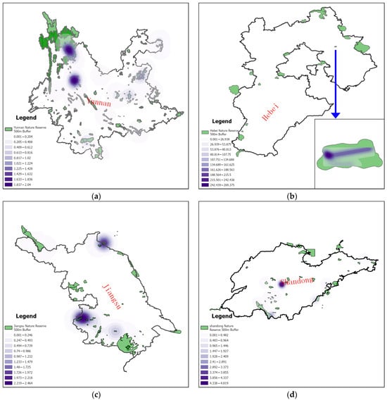
Figure 2.
Conflict zones between Yunnan (a), Hebei (b), Jiangsu (c), and Shandong (d) railway networks and national nature reserves.
4.3. Governance Experiments
In the context of the deep integration of territorial spatial planning and comprehensive transportation networks, governance experiments focused on ecology and sustainability are essential. They provide innovative frameworks to address complex environmental challenges effectively.
The Transportation-Oriented Ecological Restoration (TOER) pilot project in China’s national parks serves as an innovative vehicle for governance experimentation. This project explores a new model for the coordinated development of transportation infrastructure and ecological conservation, driven by the dual forces of institutional constraints and policy responses. Central to the TOER pilot project is the concept of “the ‘life community’ concept integrating mountains, rivers, forests, and grasslands” which effectively bridges the traditional disconnect between transportation planning and ecological conservation. It emphasizes systematic restoration and spatial integration, achieving physical fusion and functional complementarity between transportation facilities and ecological restoration through innovative technologies such as wildlife-friendly passages and intelligent management platforms. Focused on resolving the ‘protection–development’ dilemma, the project has established multi-level systems, including the ‘Land Space Ecological Protection and Restoration Project Acceptance Specification’, to mitigate the inertia of ‘development first’ through institutional constraints and activate multi-stakeholder participation through policy responses. Ultimately, it aims to achieve the synergistic goals of enhancing transportation functionality while increasing ecological value.
The cross-border planning alliance has transitioned from an ‘administrative region economy’ to a ‘functional zone economy’ through institutional and tool innovations, thereby offering a replicable governance paradigm for transportation network planning within the context of territorial spatial dynamics. This study examines the transportation coordination practices of the Guangdong–Hong Kong–Macao Greater Bay Area as a case study. The approach includes the establishment of independent legal entities, such as the Guangdong–Hong Kong–Macao Transportation Coordination Committee, which coordinates the formulation of cross-regional transportation special plans. Furthermore, the creation of data-sharing platforms and mutual recognition systems, exemplified by the Greater Bay Area Transportation Data Center, the promotion of aligned technical standards, the clarification of dispute resolution mechanisms through legislation, and the incorporation of blockchain and AI technologies to enhance governance efficiency collectively provide an innovative paradigm for cross-regional transportation network planning, shifting the focus from ‘physical connectivity’ to ‘institutional integration’.
4.4. Quantitative Analysis of Provincial Conflicts
To systematically evaluate the spatial trade-offs between ecological preservation and transportation development, this study conducted a province-level comparative analysis using two key indicators: EPR area (as a percentage of provincial territory) and comprehensive transportation network (railways, highways, and inland waterways) density (km per 100 km2). Data were extracted from China Statistical Yearbook (2024) and the website of the Ministry of Natural Resources of China, covering five strategically significant regions: Hebei, Jiangsu, Shandong, and Yunnan (Table 3).
Table 3.
Key indicators of province-level comparative analysis.
Key observations from Figure 3 reveal that Yunnan has the largest EPR area, but the lowest comprehensive transportation network density, which is in line with its rich ecological resources but complex terrain and difficult transportation construction. In contrast, Jiangsu possesses both the minimum EPR area but the second highest density of its comprehensive transportation network, suggesting a balance between development and protection. These quantified disparities underscore the necessity for differentiated governance: high-conflict provinces, such as Yunnan, require stringent ecological sensitivity vetoes in transport planning, while low-density regions like Hebei may prioritize the conservation of ecological connectivity when expanding their comprehensive transportation networks.
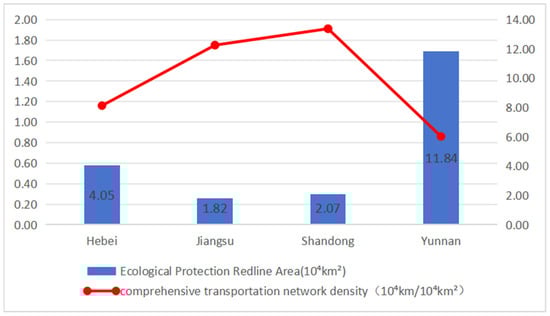
Figure 3.
Comparison of EPR area and comprehensive transportation network density in some provinces of China (2023).
Figure 4 shows a significant negative correlation (R2 = 0.75) between the area of EPR and the density of transportation networks, indicating that the strict protection of ecologically sensitive areas may limit the expansion of transportation infrastructure. This finding supports the necessity of ecological sensitivity rejection mechanisms. Pearson correlation analysis was conducted using SPSS 28.0, with significance thresholds set at p < 0.05.
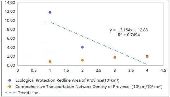
Figure 4.
Correlation analysis between EPR Area and Comprehensive Transportation Network Density.
5. International Comparative Perspectives
5.1. EU Experience: Conflict Management
Natura 2000 sites and TEN-T networks integration exemplifies EU efforts to reconcile transport and biodiversity goals. The TEN-T aims to enhance connectivity across EU member states through an extensive transport system, while the Natura 2000 sites are designed to protect valuable habitats and species under the Birds and Habitats Directives. The interplay between these two networks often leads to conflicts, since the urban and infrastructure development associated with the TEN-T may encroach upon Natura 2000 areas, which are designated to conserve biodiversity and maintain ecological integrity. An analysis of urbanization trends indicates that urban cover within Natura 2000 sites is significantly lower than that outside these areas; however, urban growth rates within Natura 2000 sites are increasing, suggesting an incipient urban sprawl that could jeopardize conservation objectives [3]. To address these challenges, spatial planning must prioritize eco-friendly integration strategies. This involves assessing and mitigating the potential adverse effects of the Trans-European Transport Network (TEN-T) on Natura 2000 sites. For example, 34% of TEN-T corridors within Natura 2000 sites exhibit high conflict levels (Figure 5), according to data from the European Commission (2023) and EEA (2023). Policies should ensure that the development of transport infrastructure takes into account ecological connectivity and functions, thereby fostering resilience in protected areas. Effective land management approaches could employ comprehensive planning tools that consider ecological factors, aiding in achieving a balance between transport infrastructure and biodiversity protection [47]. Member States of the European Union are urged to implement stricter legal protections for Natura 2000 sites, particularly in areas where urban sprawl presents a significant threat. Efforts should focus on minimizing conflicts between biodiversity conservation and transportation development. For instance, connectivity measures can enhance wildlife movement across transport corridors, thereby preserving ecological networks despite infrastructure expansion [48]. Furthermore, advancing methodologies in spatial planning can better align these network objectives. By employing ecological theories and data analysis, planners can more effectively assess the impacts of transit-oriented development on biodiversity. Cross-sector collaboration is crucial, particularly through transnational partnerships that can strengthen conservation initiatives related to Natura 2000. Such cooperation is vital for aligning transportation policies with environmental goals, ultimately enhancing the ecological integrity of protected areas [49,50]. Effective management and strategic planning, supported by strong collaboration among stakeholders, can lead to the successful integration of infrastructure development and biodiversity conservation objectives within the framework of the European Union’s environmental policies.
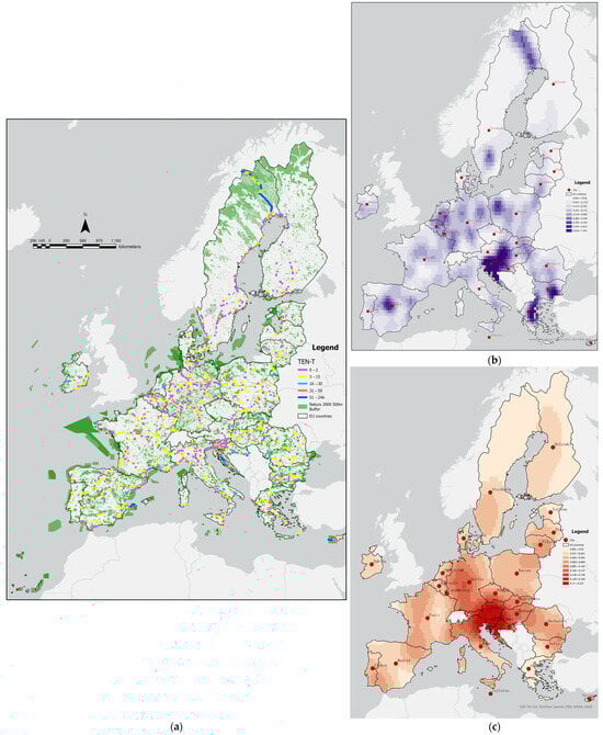
Figure 5.
Spatial conflicts between TEN-T network and Natura 2000 sites in the EU. (a) TEN-T network layout within a 500 m buffer range of Natura 2000 sites. (b) TEN-T network density distribution pattern based on Natura 2000 sites. (c) City density distribution pattern based on TEN-T network layout within a 500 m buffer range of Natura 2000 sites.
Figure 5b shows that the distribution of urban density within the 500 m buffer zone of the TEN-T network in Natura 2000 sites is extremely uneven, with the highest density value reaching 1.991 (such as cities like Bialystok and Galletta), indicating that the urbanization and transportation networks in these areas overlap heavily with the boundaries of protected areas, posing significant potential ecological disturbance risks. Figure 5c shows that the density peak of the TEN-T network in the Natura 2000 core area is only 0.237 (such as Stockholm and Berlin), indicating that the density of transportation infrastructure within the protected area is relatively low. However, the gradient difference between the buffer zone and the core area may still cause fragmentation of ecological corridors.
5.2. Japan’s Compact City Model: Lessons for TOD Integration
The concept of compact cities, particularly in relation to Transit-Oriented Development (TOD), is gaining traction in urban planning across various global contexts, including Japan. This approach aims to create high-density, mixed-use environments that optimize access to public transit while promoting sustainable living and reducing the reliance on automobiles. Compact city policies have been implemented to encourage the development of urban areas that are closely connected to public transport systems. This model is characterized by the concentration of residential, commercial, and recreational spaces within walking distance of transit stations. The goal is to facilitate ease of movement and increase public transport usage, thereby enhancing physical activity among residents and contributing to public health objectives [51]. Policies promoting mixed land use and high population densities in proximity to transit hubs are instrumental in achieving sustainable urban development [24]. Furthermore, public transportation services, including buses and rail systems, are designed to integrate with urban planning, thereby enhancing connectivity and accessibility to services and amenities. This integration is crucial for realizing the desired outcomes of compact development [52]. The amalgamation of residential areas with local amenities near transit stops fosters an appealing environment, encouraging individuals to choose public transportation over private vehicles [53]. This paradigm contrasts with the traditional urban sprawl, where residents often rely on cars due to the dispersion of services and amenities. This reliance leads to increased carbon emissions and reduced physical activity levels among the populace [54]. However, compact city policies are not solely focused on optimizing transportation; they also address secondary concerns such as housing affordability and the sustainable use of urban land. While dense development around transit hubs can lead to increased housing prices, strategic planning aims to balance growth with affordability by integrating diverse housing options within these compact areas [55]. This approach enhances social equity by providing accessible living conditions for various socio-economic groups, thereby reinforcing community resilience [56]. By employing techniques such as the node–place model, transportation hubs (nodes) are integrated with community functions (places), emphasizing their dual role as both transportation centers and vibrant spaces for social interaction and community activities [57]. This integration further reflects the holistic approach inherent in Japanese urban planning. Japan’s experience with compact city policies significantly shapes Transit-Oriented Development by ensuring that urban environments are designed not only for efficiency but also for livability and accessibility. This multifaceted approach enhances the functionality of public transport systems while promoting environmental sustainability and community engagement, serving as a valuable blueprint for other urban centers grappling with similar challenges.
As shown in Table 4, while the EU relies on legal compliance to mitigate Natura 2000 sites and TEN-T networks conflicts, China’s ‘ecological veto’ empowers administrative agencies to directly block projects, offering a more proactive approach to spatial governance.
Table 4.
Comparative analysis of spatial governance tools.
China’s ‘ecological veto’ mechanism offers a scalable model for Global South countries facing rapid urbanization. For instance, Southeast Asian nations could adopt similar institutional constraints to balance Mekong River infrastructure projects with biodiversity conservation.
6. Conclusions and Policy Pathways
6.1. Key Findings
This study demonstrates that China’s ‘three zones and three lines’ territorial spatial planning system, when integrated with a hybrid governance model of top-down ecological constraints and bottom-up technological innovation, can significantly mitigate conflicts between transportation development and ecological conservation. Key empirical results include:
- Conflict reduction: the implementation of ecological sensitivity veto mechanisms reduced spatial conflicts effectively (e.g., reduced by 18% in the Yangtze River Economic Belt, with rerouting of 32% of railway projects in high-risk zones).
- Spatial trade-offs: a strong negative correlation (R2 = 0.75) exists between ecological protection redline (EPR) coverage and transportation network density, necessitating differentiated governance strategies (e.g., stricter veto enforcement in Yunnan vs. connectivity optimization in Shandong).
6.2. Theoretical Contributions
By integrating Douglass North’s theory of institutional change with Elinor Ostrom’s theory of polycentric governance, this study proposes a three-dimensional analytical framework (Figure 6). This framework introduces ecological veto power as a binding mechanism to disrupt path-dependent transportation planning practices. Unlike North’s emphasis on incremental institutional evolution, the ‘constraint-coupling-innovation’ framework (Figure 7) illustrates how rigid ecological thresholds, such as EPR compliance mandates, can override short-term economic priorities. Additionally, digital tools, including AI conflict detection and GIS simulations, facilitate adaptive governance. This approach addresses the limitations of Ostrom’s polycentric theory in hierarchical contexts, offering a novel perspective—spatial institutionalism—for analyzing land use conflicts amid centralized–decentralized tensions.
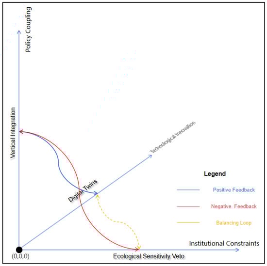
Figure 6.
Constraint-coupling-innovation framework: a system dynamics model.
Figure 7.
‘Spatial institutionalism’ framework.
The ‘spatial institutionalism’ framework encompasses three pivotal dimensions: (1) Institutional constraints: the ecological sensitivity veto acts as a binding mechanism to mitigate development pressures. (2) Policy coupling: this entails the vertical integration of national objectives, such as the dual carbon initiative, with local experiments, as exemplified by TOER pilots. (3) Technological innovation: the framework utilizes AI-driven conflict detection and digital twin simulations to enhance planning outcomes. By integrating institutional, spatial, and technological dynamics, this framework surpasses the limitations inherent in traditional sectoral analyses.
6.3. Policy Recommendations
First, it is essential to establish the National Transportation Spatial Governance Index (NTSGI) as a valuable framework for evaluating and enhancing the governance and efficacy of the national transportation system. The NTSGI should integrate three sub-indices: (1) Ecological Compliance Rate (ECR), (2) Land Use Efficiency (LUE), (3) Multi-Stakeholder Satisfaction (MSS). Pilot testing in Yunnan Province could prioritize ECR to prevent railway encroachment into protected valleys. Furthermore, the NTSGI encourages interagency collaboration and public participation in the comprehensive transportation planning process, ensuring that the perspectives of all stakeholders are integrated into governance practices.
Second, revising the ‘Land and Space Planning Law’ to incorporate specific provisions regarding the resilience of integrated transportation networks is imperative. All provincial transport plans should undergo mandatory Environmental Performance Review (EPR) compliance audits, with results made publicly accessible via the Ministry’s Geographic Information System (GIS) platform.
Third, establishing market-based trading of development rights (TDR) in ecologically sensitive corridors (e.g., Yangtze River Basin) is crucial for implementing cross-border ecological compensation.
6.4. Future Research
First, research on climate adaptation strategies for key transportation corridors is essential for mitigating the risks that climate change poses to infrastructure. The impacts of climate change, particularly extreme weather events, can significantly affect roads and transportation systems, resulting in increased vulnerability and operational disruptions. Additionally, the rising frequency and intensity of precipitation and storms will influence the design and planning of infrastructure.
Second, it is crucial to enhance the research on the behavioral analysis of stakeholders involved in planning conflicts. This is vital for improving governance and decision-making frameworks, as such analyses can facilitate better conflict resolution and support participatory governance within the planning process. Stakeholders in this context may include local residents, government agencies, non-governmental organizations (NGOs), and private developers. The focus should be on understanding how different stakeholder groups interact, relate, and respond in various planning scenarios and conflicts. This approach not only lends greater legitimacy to proposed solutions but also establishes a foundation for more sustainable and inclusive planning practices.
Author Contributions
Conceptualization, H.Y. and Y.J.; methodology, H.Y. and W.H.; writing—original draft preparation, H.Y. and Y.J.; writing—review and editing, H.Y. and Y.J.; figures, D.Y.; funding acquisition, H.Y. All authors have read and agreed to the published version of the manuscript.
Funding
This research was supported by Fundamental Research Funds for Central-Level Public Welfare Scientific Research Institutes (No. 20256117).
Institutional Review Board Statement
Not applicable.
Informed Consent Statement
Not applicable.
Data Availability Statement
The original contributions presented in this study are included in the article. Further inquiries can be directed to the corresponding author.
Conflicts of Interest
Author Wei Huang was employed by the company CCCC Water Transport Planning and Design Institute Co., Ltd. The remaining authors declare that the research was conducted in the absence of any commercial or financial relationships that could be construed as a potential conflict of interest.
References
- Oleszczuk, R.; Bajkowski, S.; Urbański, J.; Pawluśkiewicz, B.; Małuszyński, M.J.; Małuszyńska, I.; Jadczyszyn, J.; Hewelke, E. The Impacts of Beaver Dams on Groundwater Regime and Habitat 6510. Land 2024, 13, 1902. [Google Scholar] [CrossRef]
- Hermoso, V.; Morán-Ordóñez, A.; Canessa, S.; Brotons, L. Realising the potential of Natura 2000 to achieve EU conservation goals as 2020 approaches. Sci. Rep. 2019, 9, 16087. [Google Scholar] [CrossRef] [PubMed]
- Concepción, E.D. Urban sprawl into Natura 2000 network over Europe. Conserv. Biol. J. Soc. Conserv. Biol. 2021, 35, 1063–1072. [Google Scholar] [CrossRef] [PubMed]
- Zong, L.; Yang, F.; Pei, X. Implementing Climate Change Adaptation in Territory Spatial Planning Systems: Challenges and Approaches Based on Practices in Guiyang. Int. J. Environ. Res. Public Health 2022, 20, 490. [Google Scholar] [CrossRef]
- Feng, P.; Lu, T.; Yu, Y.; Gao, R.; Ni, T. Effects measurement and spatial differentiation in synergy between pollution and carbon reduction in national urban agglomerations. PLoS ONE 2023, 18, e0289801. [Google Scholar] [CrossRef]
- Xu, Y.; Cui, M. Research on the impact of regional integration policy on carbon emissions—Taking the Yangtze River Economic Belt as an example. PLoS ONE 2024, 19, e0301968. [Google Scholar] [CrossRef]
- Liu, X.M.; Zhang, Y.Q. Digital transformation, green innovation, and carbon emission reduction performance of energy-intensive enterprises. Sci. Rep. 2024, 14, 3905. [Google Scholar] [CrossRef]
- Meng, X.; Shaikh, G.M. Evaluating Environmental, Social, and Governance Criteria and Green Finance Investment Strategies Using Fuzzy AHP and Fuzzy WASPAS. Sustainability 2023, 15, 6786. [Google Scholar] [CrossRef]
- Zeng, S.; Yu, Y.; Li, W. Prediction and evaluation of the energy structure under the green finance development in Chongqing municipality, China. Heliyon 2023, 9, e22481. [Google Scholar] [CrossRef]
- Ostrom, E. A General Framework for Analyzing Sustainability of Social-Ecological Systems. Science 2009, 325, 419–422. [Google Scholar] [CrossRef]
- Keibach, E.; Shayesteh, H. The Implementation of Digital Tools for Climate Adaptation Planning. In Proceedings of the 5th International Conference on Building Energy and Environment, Montréal, QC, Canada, 25–29 July 2022; pp. 2773–2783. [Google Scholar] [CrossRef]
- Min, J.; Liu, Z. Science, technology and innovation driving urban land use and urban planning development: Policy and practice. Appl. Math. Nonlinear Sci. 2024, 9. [Google Scholar] [CrossRef]
- Hersperger, A.M.; Thurnheer-Wittenwiler, C.; Tobias, S.; Folvig, S.; Fertner, C. Digitalization in land-use planning: Effects of digital plan data on efficiency, transparency and innovation. Eur. Plan. Stud. 2021, 30, 2537–2553. [Google Scholar] [CrossRef]
- Wei, H.; Zuo, T.; Líu, H.; Yang, Y.-T. Integrating Land Use and Socioeconomic Factors into Scenario-Based Travel Demand and Carbon Emission Impact Study. Urban Rail Transit 2017, 3, 3–14. [Google Scholar] [CrossRef] [PubMed]
- Nault, E.; Jusselme, T.; Aguacil, S.; Andersen, M. Strategic environmental urban planning-A contextual approach for defining performance goals and informing decision-making. Build. Environ. 2020, 168, 106448. [Google Scholar] [CrossRef]
- Zhao, G.; Zheng, X.; Yuan, Z.; Zhang, L. Spatial and Temporal Characteristics of Road Networks and Urban Expansion. Land 2017, 6, 30. [Google Scholar] [CrossRef]
- Griffin, G.P.; Jiao, J. The Geography and Equity of Crowdsourced Public Participation for Active Transportation Planning. Transp. Res. Rec. 2019, 2673, 460–468. [Google Scholar] [CrossRef]
- Lee, R.J.; Sener, I.N. Transportation Planning and Quality of Life: Where Do They Intersect? Transp. Policy 2016, 48, 146–155. [Google Scholar] [CrossRef]
- Logan, J.R. Making a Place for Space: Spatial Thinking in Social Science. Annu. Rev. Sociol. 2012, 38, 507–524. [Google Scholar] [CrossRef]
- Bozorgmehr, K. Rethinking the ‘global’ in global health: A dialectic approach. Glob. Health 2010, 6, 19. [Google Scholar] [CrossRef]
- Orford, S.; Webb, B. Mapping the interview transcript: Identifying spatial policy areas from daily working practices. Area 2018, 50, 529–541. [Google Scholar] [CrossRef]
- Franklin, R.S.; Delmelle, E.C.; Andris, C.; Cheng, T.; Dodge, S.; Franklin, J.; Heppenstall, A.; Kwan, M.P.; Li, W.; McLafferty, S.; et al. Making Space in Geographical Analysis. Geogr. Anal. 2023, 55, 325–341. [Google Scholar] [CrossRef] [PubMed]
- Tosun, J.; Saad, E.L.; Glückler, J.; Irigoyen Rios, A.; Lehmann, R. Country-Specific Participation Patterns in Transnational Governance Initiatives on Sustainability: Preliminary Insights and Research Agenda. Glob. Chall. 2023, 7, 2300012. [Google Scholar] [CrossRef] [PubMed]
- Das, A.; Roy, S. The new institutional economic approach to land development game: Integrating transaction cost and efficient institutional framework in synergic urban land use-transport development model. Heliyon 2023, 9, e12793. [Google Scholar] [CrossRef] [PubMed]
- Caparros-Midwood, D.; Barr, S.; Dawson, R. Spatial Optimization of Future Urban Development with Regards to Climate Risk and Sustainability Objectives. Risk Anal. Off. Publ. Soc. Risk Anal. 2017, 37, 2164–2181. [Google Scholar] [CrossRef]
- Wang, Z.; Huang, L.; Xu, M.; Wang, S. Bridging the science-practice gaps in nature-based solutions: A riverfront planning in China. Ambio 2021, 50, 1532–1550. [Google Scholar] [CrossRef]
- Hou, Q.; Li, Q.; Yang, Y.; Zhou, J.; Du, Y.; Zhang, Y. Evaluation and optimization of ecological spatial resilience of Yanhe River Basin based on complex network theory. Sci. Rep. 2024, 14, 1361. [Google Scholar] [CrossRef]
- Xu, J.; Xu, D.; Qu, C. Construction of Ecological Security Pattern and Identification of Ecological Restoration Zones in the City of Changchun, China. Int. J. Environ. Res. Public Health 2022, 20, 289. [Google Scholar] [CrossRef]
- Guo, J.; Yue, D.; Li, K.; Hui, C. Biocapacity optimization in regional planning. Sci. Rep. 2017, 7, 41150. [Google Scholar] [CrossRef]
- Ou, M.; Li, J.; Fan, X.; Gong, J. Compound Optimization of Territorial Spatial Structure and Layout at the City Scale from “Production-Living-Ecological” Perspectives. Int. J. Environ. Res. Public Health 2022, 20, 495. [Google Scholar] [CrossRef]
- Qu, Y.; Lu, M. Identifying conservation priorities and management strategies based on ecosystem services to improve urban sustainability in Harbin, China. PeerJ 2018, 6, e4597. [Google Scholar] [CrossRef]
- Gerlak, A.K.; Saguier, M.; Mills-Novoa, M.; Fearnside, P.M.; Albrecht, T.R. Dams, Chinese investments, and EIAs: A race to the bottom in South America? Ambio 2020, 49, 156–164. [Google Scholar] [CrossRef] [PubMed]
- Tampekis, S.; Sakellariou, S.; Samara, F.; Sfougaris, A.; Jaeger, D.; Christopoulou, O. Mapping the optimal forest road network based on the multicriteria evaluation technique: The case study of Mediterranean Island of Thassos in Greece. Environ. Monit. Assess. 2015, 187, 687. [Google Scholar] [CrossRef] [PubMed]
- Li, Z.; Zhu, J. Assessment and spatial partitioning of ecosystem services importance in Giant Panda National Park: To provide targeted ecological protection. PLoS ONE 2022, 17, e0278877. [Google Scholar] [CrossRef]
- Kim, E.S.; Lee, D.K.; Choi, J. Evaluating the effectiveness of mitigation measures in environmental impact assessments: A comprehensive review of development projects in Korea. Heliyon 2024, 10, e31647. [Google Scholar] [CrossRef] [PubMed]
- Han, H.; Li, H.; Zhang, K. Spatial-Temporal Coupling Analysis of the Coordination between Urbanization and Water Ecosystem in the Yangtze River Economic Belt. Int. J. Environ. Res. Public Health 2019, 16, 3757. [Google Scholar] [CrossRef]
- Whitehorn, P.R.; Navarro, L.M.; Schröter, M.; Fernandez, M.; Rotllan-Puig, X.; Marques, A. Mainstreaming biodiversity: A review of national strategies. Biol. Conserv. 2019, 235, 157–163. [Google Scholar] [CrossRef]
- Lu, J.; Wang, K.; Liu, H. Land Development Rights, Spatial Injustice, and the Economic Development in Net-Incremental Reduction Regions of Construction Land: Evidence from Shanghai, China. Int. J. Environ. Res. Public Health 2023, 20, 2560. [Google Scholar] [CrossRef]
- Wang, A.Q.; Chan, E.H.W.; Yeung, S.C.W.; Han, J.B. Urban Fringe Land Use Transitions in Hong Kong: From New Towns to New Development Areas. Procedia Eng. 2017, 198, 707–719. [Google Scholar] [CrossRef]
- Seto, K.; Galland, G.R.; McDonald, A.; Abolhassani, A.; Azmi, K.; Sinan, H.; Timmiss, T.; Bailey, M.; Hanich, Q. Resource allocation in transboundary tuna fisheries: A global analysis. Ambio 2021, 50, 242–259. [Google Scholar] [CrossRef]
- Ye, Y.; Qin, Y.; Yu, R.; Wu, Q. Optimization of Chinese land spatial pattern in the transformation process of resource-based cities: A case study in Tongling City, China. Sci. Rep. 2024, 14, 6092. [Google Scholar] [CrossRef]
- de Souza, A.M.; Maia, G.; Braun, T.; Villas, L.A. An Interest-Based Approach for Reducing Network Contentions in Vehicular Transportation Systems. Sensors 2019, 19, 2325. [Google Scholar] [CrossRef] [PubMed]
- Azami, P.; Jan, T.; Iranmanesh, S.; Ameri Sianaki, O.; Hajiebrahimi, S. Determining the Optimal Restricted Driving Zone Using Genetic Algorithm in a Smart City. Sensors 2020, 20, 2276. [Google Scholar] [CrossRef] [PubMed]
- Ye, X.; Du, J.; Han, Y.; Newman, G.; Retchless, D.; Zou, L.; Cai, Z. Developing Human-Centered Urban Digital Twins for Community Infrastructure Resilience: A Research Agenda. J. Plan. Lit. 2022, 38, 187–199. [Google Scholar] [CrossRef] [PubMed]
- Hasanujjaman, M.; Chowdhury, M.Z.; Jang, Y.M. Sensor Fusion in Autonomous Vehicle with Traffic Surveillance Camera System: Detection, Localization, and AI Networking. Sensors 2023, 23, 3335. [Google Scholar] [CrossRef]
- Kumar, A.; Kannan, K.; Dahiya, M.; Kushwah, V.S.; Siddiqa, A.; Kaur, K.; Rahin, S.A. Advances in Computational Intelligence Techniques-Based Multi-Intersection Querying Theory for Efficient QoS in the Next Generation Internet of Things. Comput. Intell. Neurosci. 2023, 2023, 1388425. [Google Scholar] [CrossRef]
- Fenu, G.; Pau, P.L.; Dessì, D. Functional models and extending strategies for ecological networks. Appl. Netw. Sci. 2017, 2, 10. [Google Scholar] [CrossRef]
- Friedrichs, M.; Hermoso, V.; Bremerich, V.; Langhans, S.D. Evaluation of habitat protection under the European Natura 2000 conservation network—The example for Germany. PLoS ONE 2018, 13, e0208264. [Google Scholar] [CrossRef]
- Nita, A.; Rozylowicz, L.; Manolache, S.; Ciocănea, C.M.; Miu, I.V.; Popescu, V.D. Collaboration Networks in Applied Conservation Projects across Europe. PLoS ONE 2016, 11, e0164503. [Google Scholar] [CrossRef]
- Maes, J.; Barbosa, A.; Baranzelli, C.; Zulian, G.; Batista, E.; Silva, F.; Vandecasteele, I.; Hiederer, R.; Liquete, C.; Paracchini, M.L.; et al. More green infrastructure is required to maintain ecosystem services under current trends in land-use change in Europe. Landsc. Ecol. 2015, 30, 517–534. [Google Scholar] [CrossRef]
- Thrun, E.; Leider, J.; Chriqui, J.F. Exploring the Cross-Sectional Association between Transit-Oriented Development Zoning and Active Travel and Transit Usage in the United States, 2010–2014. Front. Public Health 2016, 4, 113. [Google Scholar] [CrossRef]
- Lu, Y.; Gou, Z.; Xiao, Y.; Sarkar, C.; Zacharias, J. Do Transit-Oriented Developments (TODs) and Established Urban Neighborhoods Have Similar Walking Levels in Hong Kong? Int. J. Environ. Res. Public Health 2018, 15, 555. [Google Scholar] [CrossRef] [PubMed]
- Coxa, L.; Bassi, A.; Kolling, J.; Procter, A.; Flanders, N.; Tanners, N.; Araujo, R. Exploring synergies between transit investment and dense redevelopment: A scenario analysis in a rapidly urbanizing landscape. Landsc. Urban Plan. 2017, 167, 429–440. [Google Scholar] [CrossRef] [PubMed]
- Song, C.; Liu, Q.; Song, J.; Yang, D.; Jiang, Z.; Ma, W.; Niu, F.; Song, J. The Interactive Relationship between Street Centrality and Land Use Intensity-A Case Study of Jinan, China. Int. J. Environ. Res. Public Health 2023, 20, 5127. [Google Scholar] [CrossRef] [PubMed]
- Lu, Y.; Sun, G.; Sarkar, C.; Gou, Z.; Xiao, Y. Commuting Mode Choice in a High-Density City: Do Land-Use Density and Diversity Matter in Hong Kong? Int. J. Environ. Res. Public Health 2018, 15, 920. [Google Scholar] [CrossRef]
- Yan, R.; Yang, B. Interactive effects of the built environment and rail transit on commuting behavior: Evidence from Hefei, China. Heliyon 2023, 9, e21788. [Google Scholar] [CrossRef]
- Hino, K.; Taniguchi, A.; Hanazato, M.; Takagi, D. Modal Shift from Cars and Promotion of Walking by Providing Pedometers in Yokohama City, Japan. Int. J. Environ. Res. Public Health 2019, 16, 2144. [Google Scholar] [CrossRef]
Disclaimer/Publisher’s Note: The statements, opinions and data contained in all publications are solely those of the individual author(s) and contributor(s) and not of MDPI and/or the editor(s). MDPI and/or the editor(s) disclaim responsibility for any injury to people or property resulting from any ideas, methods, instructions or products referred to in the content. |
© 2025 by the authors. Licensee MDPI, Basel, Switzerland. This article is an open access article distributed under the terms and conditions of the Creative Commons Attribution (CC BY) license (https://creativecommons.org/licenses/by/4.0/).