Article

The Interpretation of Historical Layer Evolution Laws in Historic Districts from the Perspective of the Historic Urban Landscape: A Case Study in Shenyang, China

1
School of Architecture & Fine Art, Dalian University of Technology, Dalian 116024, China
2
School of Marxism, Beijing Forestry University, Beijing 100083, China
*
Author to whom correspondence should be addressed.
Land 2025, 14(5), 1029; https://doi.org/10.3390/land14051029
Submission received: 30 March 2025 / Revised: 30 April 2025 / Accepted: 7 May 2025 / Published: 8 May 2025

Abstract

:
In the context of global urbanization and the concomitant tension between heritage conservation and urban development, there is an urgent need to explore effective strategies for addressing the challenges posed by fragmented conservation, static cognition, and homogeneous renewal in conservation practice. Utilizing the theoretical framework of urban historic landscape, this study integrates urban morphology, architectural typology, urban imagery, and catalyst theory to formulate a progressive study on the evolution of historic districts through the layers of “historic areas, spatial forms, material carriers, value characteristics”. The research path is a progressive one that analyses the regularity of historic districts. The present study focuses on Shenyang as the object of empirical research, employing a multifaceted research method that integrates multiple scenarios and sub-cases within a single case. This method utilizes a combination of the literature and field research to obtain diversified data. The study then undertakes a systematic analysis of the accumulation of Shenyang’s historic districts through the application of kernel density analysis and geometric graphical methods. The study found that the dimension of the historical area of the Shenyang historic district presents the layering law of “single-core dominant–dual-core juxtaposition–fusion collage–extension–multi-point radiation”, and that the spatial form is summarized as seven types of the layering law, such as radiation type, ring type, triangular type, and grid type. The spatial form is summarized into seven types of laminar laws, such as radial, ring, triangular, grid, etc. The material carriers exhibit the conventional law of anchoring point-like elements, employing line-like elements as the skeletal structure and surface-like elements as the matrix. The value laminations are diversified, centralized, and self-adaptive. The study proposes the concept of “layer accumulation law” to elucidate the carrier transformation mechanism of cultural genes, and it provides a methodological tool for addressing the dilemma of “layer accumulation fracture”. The findings of this study not only deepen the localized application of HUL theory but also provide an innovative path for the practice of heritage conservation in urban renewal.

1. Introduction

In the context of accelerating global urbanization and mounting pressures for heritage conservation, the 2012 Recommendation on Historic Urban Landscapes was developed to establish an international framework for heritage conservation [1]. This framework is predicated on the theoretical underpinnings and methodological approach of “Historic Urban Landscapes”, a concept that offers guidelines to address the practical challenges posed by urban conservation and development [2]. Presently, China’s urban spatial development is undergoing a gradual transition from incremental planning to stock planning. The preservation and revitalization of historic districts as pivotal spatial and temporal conduits of urban cultural heritage are paramount to achieving a harmonious balance between cultural heritage and urban development [3,4].
Accordingly, extant conservation practices are typified by three characteristics. Firstly, they are marked by fragmented conservation. Secondly, they are distinguished by static cognition. Thirdly, they are typified by homogenized renewal [5]. The extraction of architectural monoliths, decorative elements, or local plots from the original spatial texture, as well as the replacement of systematic survival with “point protection”, the cutting of the spatial connection between buildings and alleys, and the disintegration of the spatial sequences on which the spirit of the place exists, are manifestations of the fragmentation of conservation [6,7]. Static cognition disregards the fact that the built environment of historic districts is the result of construction, use, and transformation in different periods. The principle of “repairing the old as the old” anchors the “historical value” in a specific period of time. This principle not only obscures the continuity of the building’s life cycle but also blocks the natural evolution of the function to meet social needs. The principle of “repairing the old as the old” is predicated on the “historical value” of a given moment in time. This principle obscures the continuity of the building life cycle and hinders the natural evolution of a space’s function to adapt to social needs. The homogenization of renewal processes contributes to the simplification of the complexity inherent in historic districts, thereby reducing their heterogeneity [8]. This simplification is achieved through the transformation of diverse regional characteristics into replicable cultural symbols, which, in turn, are mass-produced and commercialized. Consequently, the spatial forms of historic districts in different regions converge, resulting in a uniformity that is characterized by the replication of mass-produced commercial templates [9,10].
Following the publication of The Recommendation on Historic Urban Landscapes in 2011, the Historic Urban Landscape Theory has gradually become an important paradigm in the field of international heritage conservation [11]. The theory has been shown to overcome the limitations of traditional conservation concepts, which regard historic urban areas as “static conservation”, and emphasizes their dynamic development characteristics as “living heritage” (UNESCO, 2011) [12]. In terms of application, the HUL framework calls for the harmonious integration of heritage conservation and urban development through layer analysis, value identification, and dynamic management [13]. This approach resonates with the emergence of the “processual spatial view” in contemporary urban research, which emphasizes the conception of urban space as a historical outcome of the interplay between the reproduction of social relations and the evolution of material forms [14].
The Recommendation on Historic Urban Landscapes (2011) establishes the historical stratification approach as a significant methodology for heritage conservation, emphasizing that the nature of historic urban landscapes is a dynamic product of natural evolution and humanistic accumulation [15]. Urban areas are formed by the superimposition of numerous cultural genes and natural elements over time, and their value characteristics are not only reflected in the spatial and temporal superposition of material remains but also originate from the material projection of social relationship networks and cultural practices at different historical stages [16]. Among these factors, “historical accumulation” is understood to signify the composite structure of urban space that has been shaped over an extended evolutionary cycle [17]. This accumulation encompasses not only identifiable architectural entities and imprints of places but also immaterial collective memories and traces of the reiteration of technological paradigms.
The proposal posits the utilization of historical stratification analysis as a methodology for the systematic documentation and examination of the townscape’s evolution over time. Furthermore, it advocates for the establishment of a multidimensional spatial and temporal database, with the objective of presenting the transformation logic of the spatial form and social functions in different periods [18]. The application of this approach is twofold. Firstly, it serves to reveal the dynamic process of heritage value generation, thereby providing empirical support for the demonstration and implementation of conservation planning [19]. Secondly, it optimizes the accuracy and adaptability of conservation strategies by identifying key stratification interfaces and vulnerability elements. Scientific knowledge of the layered structure can help balance the needs of original conservation and sustainable development so that the historic landscape can realize the living inheritance of cultural genes and the creative transformation of functional values in contemporary urban renewal [20].
The law of layers is a typical expression of the process of accumulation of historic districts. This is a specific expression formed under different conditions of time, space, and motivation in the process of continuous evolution. It objectively reflects the unique evolution path and organization of historic districts [21]. The law of stratification can be defined as the summary and abstraction of the stratification process, which is the structured expression of the elements formed in the dynamic accumulation in different periods. It simultaneously reveals the personalized characteristics of the evolution of the neighborhoods, reflecting how the multiple elements are integrated and present unique forms in the specific environment. The layering of historic districts essentially reflects urban space as a material carrier of the “socio-spatial dialectic”. The theory of spatial production proposed by Lefebvre underscores that urban space functions not only as a medium for social relations but also as a site for the exercise of social power. The evolution of the layers of historic districts can be conceptualized as a “layered text” formed by the interaction of political and economic forces, social and cultural practices, and spatial production mechanisms in different historical periods [22].
In his seminal work “Urban Imagery”, Kevin Lynch propounded the concept of the five major components of the urban environment, which he termed “roads, boundaries, areas, nodes, and markers” [23]. In addition, Professor Qi K. proposed in the treatise “Urban Architecture” that the urban landscape structure has five aspects: “axis, nucleus, cluster, shelf, and skin” 5 aspects [24]; scholar Liu Y.W. proposed the law of “anchoring-layer” [25]; scholar Ding S.S. proposed the landscape layering law of “patch-corridor-substrate” from the perspective of landscape ecology [26]; scholar Yang Ning proposed the “urban landscape structure” model and the “urban landscape structure” model. “Scholars Yang Ning and Li Heping analyzed the laminar law analysis of composite carriers from the perspective of “pattern–structure–texture–fashion” [27].
The “Axis–Nucleus–Group” theory analyzes the inherent topological relationship of an urban space and establishes systematic association rules between elements. The “Anchor-Layer Accumulation Model” explains the transmission path of spatial genes and the law of intergenerational turnover by examining the material carrier dimension. The “pattern–structure–texture” system establishes the system from the macroscopic pattern of the city to the spatial pattern of the city. The “pattern–structure–texture” system establishes a progressive layer analysis from the macro pattern to the micro carrier. The dimension of value characteristics is the kernel of significance in the study of the layer law, which runs through the whole process of spatial pattern, material carrier, and time evolution. This includes the anchoring of collective memory and the iteration of the functional value.
While extant research in the domain of historic district preservation has yielded commendable outcomes [28,29,30,31], certain limitations must be acknowledged. Firstly, the research perspective is oriented toward the temporal evolution of material spatial forms, with insufficient consideration given to the spatial embedding mechanism of non-material elements. Secondly, the analytical method is biased toward single-dimensional intergenerational research, lacking the co-temporal analysis of multiple historical layers. Thirdly, the preservation strategy predominantly adopts the “freezing” preservation mode, which is ineffective in responding to the dynamic needs of contemporary urban development.
In accordance with the aforementioned theoretical underpinnings and the findings of research, the objective of this study is to establish a research framework that encompasses the following sequence: “historical area–spatial form–material carrier–value characteristics”. The study is designed to undertake a systematic analysis of the multidimensional layering law that characterizes historical districts. The research objectives of this study are as follows: (1) reconstruct the value cognition and overcome the limitations of specimen protection that are imposed by the single point in time; (2) reveal the evolution mechanism and establish the dynamic adaptation of the protection logic; and (3) identify the cultural genes and resist the erosion of homogenized renewal.
The examination of the layering law of historic districts constitutes an exhaustive decoding of the nature of their spatial and temporal evolution. This can provide a fundamental cognitive tool for overcoming the current conservation dilemma [32]. The primary significance encompasses the following: The theoretical paradigm of urban historic landscapes is to be expanded based on the analysis of the historical layering law of historic streets. A theoretical model and methodological system of the layering evolution law of historic neighborhoods is to be established. A new methodological tool is to be provided for balancing heritage conservation and urban development.

2. Materials and Methods

2.1. Research Framework

The law of layers is a specific expression of the continuous evolution of historic districts under different conditions of time, space, and motivation. It can be considered a structured expression of the dynamic accumulation of elements in different periods. This reveals the personalized characteristics of the evolution of the districts and reflects how the multiple elements are integrated and presented in a unique form in a specific environment [33]. Drawing upon the theoretical framework of urban historic landscape, this study integrates urban morphology, architectural typology, urban imagery, and catalyst theory to formulate a progressive study on the evolution of historic districts through the layers of “historic areas–spatial forms–material carriers–value characteristics”. The research method is a progressive one that analyzes the regularity of historic districts [34]. The present study focuses on Shenyang as the object of empirical research, utilizing a systematic and multifaceted approach. This approach employs a combination of single-case embedded multi-scenario and sub-case methods to analyze the layering law of Shenyang’s historic district (Figure 1).
The theoretical framework of this study is rooted in the concept of urban historic landscape, and it employs a four-dimensional analysis system to examine the layering law of historic districts. This approach unveils the evolutionary trajectory of historic districts. The following sequence of logical links is proposed: The historical area dimension serves as the geographic foundation for spatial evolution, emphasizing the dynamics of spatial boundaries and the functional radiation effect of the historic district. This dimension unveils the logic of expansion and contraction of the “core–edge” structure across the temporal axis. The spatial morphology dimension identifies the genetic and mutation mechanisms of spatial genes through the comparison of axes, texture, and scales in the past. This dimension quantitatively characterizes the rupture and continuity of the morphological layer. The second dimension pertains to spatial morphology, which is characterized by the comparison of axes, texture, and scale over time. This facilitates the identification of the genetic and mutation mechanisms of spatial genes. Furthermore, it enables the quantitative characterization of the fracture and continuity of morphological layers. The third dimension concerns the material carrier, and it involves the establishment of an analytical model of “anchor point-–skeleton–substrate network” through analysis. The fourth dimension relates to value characteristics, and it integrates the symbiotic evolution logic of cultural, social, and economic values. Additionally, it summarizes the evolution law of value characteristics. The research framework innovatively extends the operational dimension of the HUL theory from the “identification of conservation objects” to “decoding of evolution laws”, maintaining the systematicity of historical elements and strengthening the interpretability of dynamic evolution.

2.2. Main Research Methods

The present study is grounded in an interdisciplinary research methodology system, adopting typology as the theoretical framework. This system integrates the literature and field research to categorize and sort out the characteristics of layer accumulation in different dimensions through the inductive summarization method. The law of layer accumulation is analyzed using GIS kernel density analysis and geometric illustration methods [35]. The research method of single-case embedded multi-scenarios and sub-cases is adopted, in which the Shenyang historic district is taken as the single-case research object, and the screened typical historic districts are embedded as the sub-cases, and the comparative research matrix of the sub-cases is constructed.

2.2.1. Kernel Density Analysis

Kernel density analysis is a spatial analysis tool that reveals the spatial aggregation and distribution law of resources by evaluating the density distribution of a specific object (e.g., buildings, roads, historical sites, etc.) in geographic space. In the context of investigating layering laws, the integration of data pertaining to historical and cultural resources present within historic districts across diverse temporal periods facilitates the revelation of spatial aggregation and distribution patterns. This, in turn, enables further analysis of these layering laws [36]. The process of kernel density analysis entails the calculation of density within a specified range around a given point (e.g., historical buildings, landscape structures, landmark monuments, etc.). Utilizing ArcGIS(10.7) software, the process entails the collection of spatial data and their subsequent transformation into a different format [37]. Thereafter, the selection of the spatial analysis tool and the establishment of analysis parameters are crucial steps in generating a density map or a heat map. The analysis of kernel density in different periods facilitates the identification of historical neighborhoods that have undergone processes of expansion, contraction, and reorganization, as well as changes in spatial distribution. It also provides an effective means of identifying the spatial distribution pattern of resources in historical neighborhoods, thus offering a quantitative basis for the study of the layering law of historical neighborhoods [38]. The method is both intuitive and visual, and it is capable of quantifying the spatial distribution information of historic districts. Furthermore, it is applicable to different scales and types of spatial data of historic districts.

2.2.2. Geometric Illustration Method

Geometric illustration is a technique that employs geometric shapes and relationships to represent and analyze the spatial structure and change. In the analysis of the layering pattern of historical districts, the application of the geometric illustration method reveals the complex spatial structure and evolution process through simple geometric forms. The method of revealing the spatial elements, material forms, and their interrelationships of historical districts through the construction and analysis of geometric figures is centered on the use of geometric figures (such as points, lines, surfaces, polygons, etc.) to abstract and represent the spatial elements and their relationships, and through geometric expression, the forms, sizes, distributions of the spatial elements, as well as the spatial relationships between them that can be visually demonstrated [39]. Geometric illustration functions not only as a graphical expression tool but also as an analytical instrument. Through the disassembly, comparison, and reorganization of graphics, it can reveal the inner structure and evolution of spatial elements and intuitively demonstrate how the elements of architectural form, street direction, and spatial layout are superimposed and changed, as well as their mutual relationship. By simplifying the spatial structure of the block and highlighting its morphological features through black-and-white texture diagrams, the evolution of the layers of the historical block can be identified by highly simplifying and abstracting, removing the complex details, and retaining only the basic skeleton and texture structure of the block. This approach focuses on the essence of spatial organization, layout, and change.

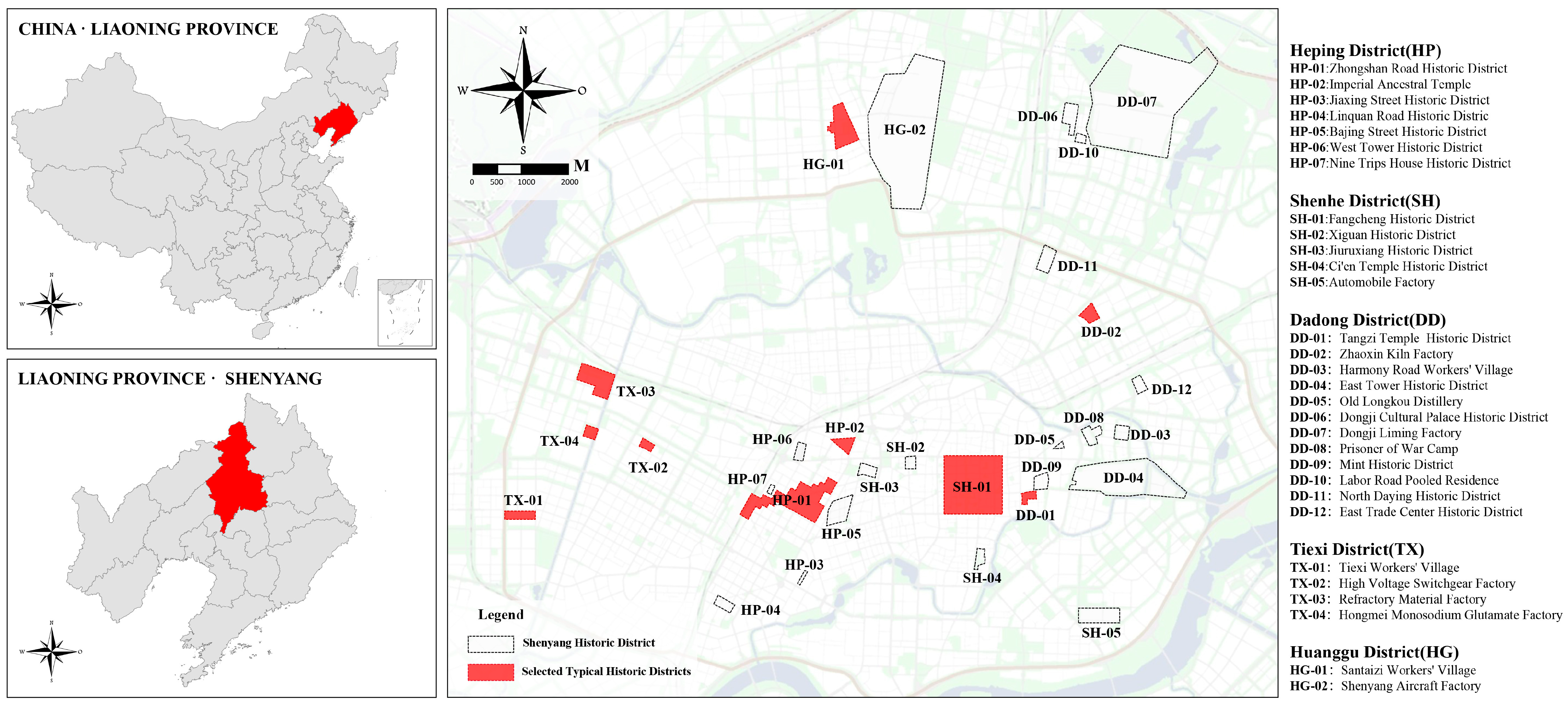
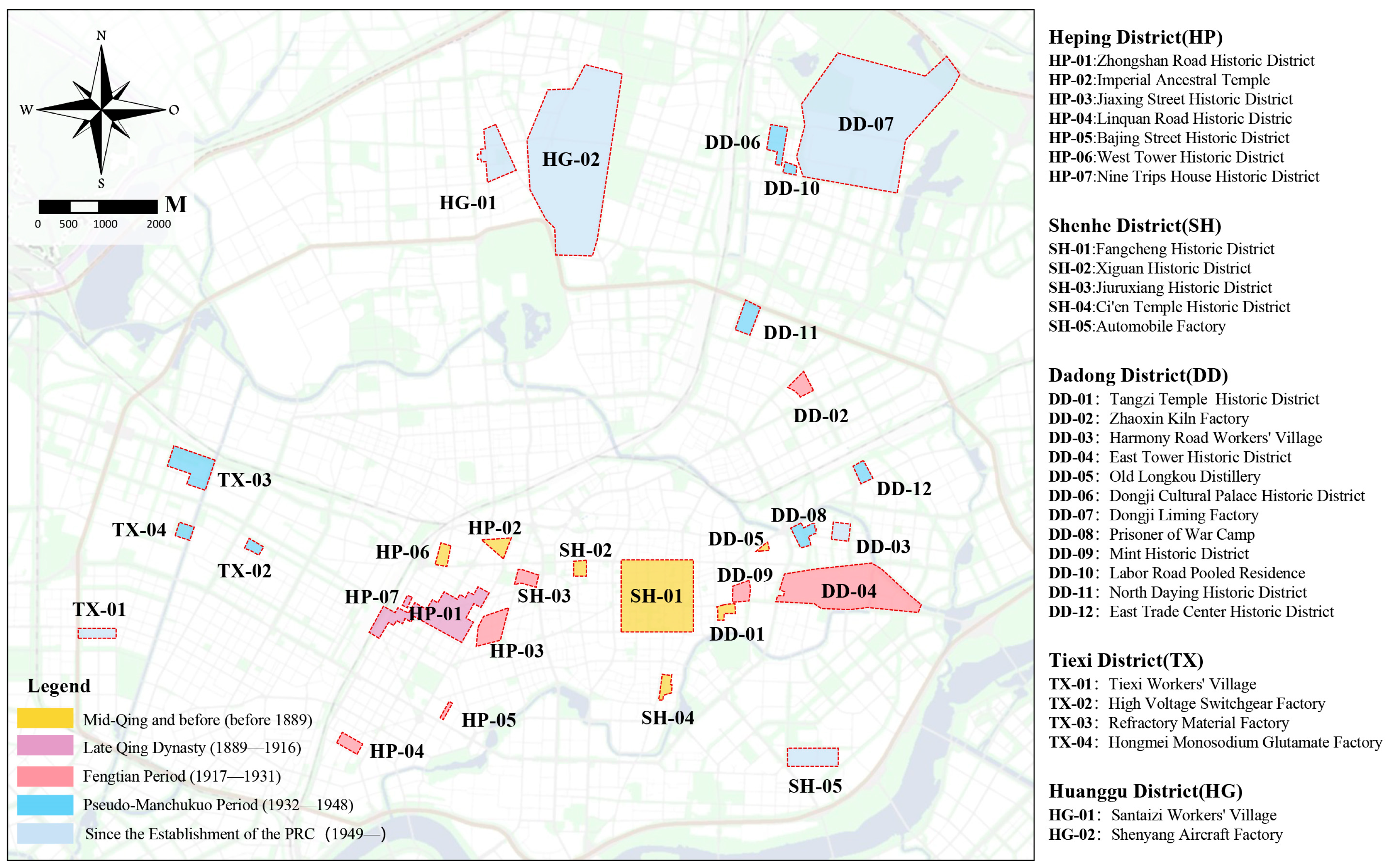
2.3. Research Subjects

The present study is underpinned by official documents made public by the Natural Resources Bureau of Shenyang City and field surveys conducted by the author, who has identified 30 historic districts within the city’s current borders. These districts encompass a variety of historical periods, including the Qing Dynasty, the Republic of China, the colonial period, and the period of planned economy (Table 1).
Shenyang City, situated in Liaoning Province (Figure 2), was selected as a case city for this study on the basis of three principal reasons:
(1) The typicality and complexity of the historical landscape of the Shenyang historic district. Shenyang is the only historical and cultural city in northeastern China with a designation of “the birthplace of a dynasty, two generations of emperors and kings”. The urban space of Shenyang carries the characteristics of successive layers from the Qing dynasty capital city to a modern colonial commercial port to a modern industrial base. In comparison with cities that possess a singular historical deposit, the complexity and typicality of Shenyang’s multicultural superposition and spatial conflict, as well as the preservation dilemma faced by this kind of city with its typicality and complexity, are worthy of further exploration and research.
(2) The preservation and advancement of the Shenyang historic district are characterized by a conspicuous contradiction. The construction of ultra-high-rise buildings has had a significant impact on the historical landscape of the city. These buildings have disrupted the traditional control thresholds of skyline development, resulting in the fragmentation of the visual corridors that characterize historical neighborhoods. The abrupt geometric volumes of these buildings have transformed the spatial sequence, reducing it to a series of isolated islands. The imposition of large-scale buildings on the historical texture of the area has been demonstrated to result in the destruction of the topological relationship between historical streets and lanes. Furthermore, the visual aggression of glass curtain walls and other building materials has been shown to dissolve the continuity of the historical landscape. This phenomenon endangers the survival of the material remains of historic neighborhoods and disrupts the cultural genealogy.
(3) Shenyang, as an international center city in Northeast Asia, is also an important pilot city for urban renewal in China. In the context of urban planning, Shenyang, as a pivotal city in the “revitalization of the Northeast”, is well positioned to leverage its strengths and share its expertise in urban preservation and regeneration. This valuable experience can serve as a significant reference point for other cities in the Northeast region. Consequently, the selection of Shenyang as a research object constitutes a favorable response to the proposition of cultural heritage in China’s new urbanization strategy.
The author employs ten archetypal historic districts—Fangcheng, Zhongshan Road, and Tiexi Workers’ Village, for example–as subordinate cases for the purpose of investigating the law of stratification in accordance with the following considerations:
(1) The extent to which the various types of buildings are represented. The ten typical historic districts selected cover the four core functional categories of “administrative function-led”, “residential function-led”, “cultural function-led”, and “industrial heritage-led”. The four core functional categories ensure that the research samples can systematically reflect the typical characteristics of Shenyang’s diversified historical spatial spectrum and avoid the duplication of types, leading to the generalization of research conclusions.
(2) Typicality of contradiction characterization. The selection criteria are based on two key factors: the “urgency of protection” and the “concentration of contradictions”. The aim is to select neighborhoods with a high risk of historical texture destruction, obvious functional decline, and serious crisis of cultural rupture. This is intended to reflect the common difficulties in the protection and regeneration of historical districts.
(3) The selection of ten typical historic districts was made in accordance with the principles of “balanced spatial distribution” and “differences in the gradient of policy interventions”. This was to ensure that the samples cover different districts and districts at different stages of protection in Shenyang. The purpose of this was to validate the differences in the protection mechanisms and the effectiveness of the policy gradient. This approach ensures that the sample encompasses diverse geographical areas and residential neighborhoods at varying stages of preservation in Shenyang, thereby verifying the variations in preservation mechanisms and the effectiveness of policy gradients.
(4) The feasibility of data collection is a pivotal consideration in the research design. Subject to the constraints of research resources, the selection of the 10 historic districts is informed by the “completeness of historical data” and “accessibility of field research”. However, given that certain industrial heritage-type historic districts in Shenyang are still in the production stage (e.g., Locomotive Signal Factory), are classified units (e.g., Shenyang Aircraft Factory, Mint), or are military management areas (e.g., Dongji Factory), it is not possible to ensure the legitimacy and reliability of the research data through field survey work.
(5) A constructed threshold for theory saturation was employed. The principle of “theory saturation” is a fundamental tenet of qualitative research, whereby the comparison of cases is able to present a stable correlation model. It is evident that the marginal contribution to theoretical innovation by continuing to increase the sample size decreases significantly. Consequently, the 10 typical historic districts can not only circumvent the potential for small samples but also prevent the dispersion of research focus caused by large samples.

3. Results

3.1. Analysis of Laminar Laws in Historical Areas

The historic area constitutes the fundamental dimension for comprehending the accumulation of historic neighborhoods [40]. This dimension encompasses not only the spatial characteristics of a specific geographical area but also the social, economic, and cultural backgrounds of a certain area in different periods. As the foundational point for the study of the law of accumulation, it serves as the spatial and temporal benchmark for the entire analytical framework. The unique social functions and developmental trajectories exhibited by different historical areas in various periods can reveal the evolution process of districts in different historical contexts and how distinctive spatial features are gradually superimposed over time. By analyzing the agglomeration degree of Shenyang historical districts through time slicing, combining the evolutionary law of urban form, functional distribution, and spatial distribution, and quantifying and interpreting the layering law of Shenyang historical districts in the regional dimension, the following laws can be deduced.
Shenyang, a prominent historical and cultural city in Northeast China, has undergone a series of transformations over the course of its urban development, resulting in a multifaceted urban landscape that encompasses multiple periods and dimensions. The urban texture of Shenyang has been shaped by a variety of spatial production strategies, each of which has left an indelible mark on the city’s development. These strategies encompass the ritual construction of the capital of the Later Jin regime, the traditional space cut by the colonial railroad at the end of the Qing Dynasty, the fusion of Chinese and Western architecture dominated by the Fenghuang warlords, the large-scale production of industrial colonization during the pseudo-Manchurian period, and the practice of socialist industrial communities after the founding of the new China (Figure 3). The 30 existing historic districts, as significant material carriers, encompass 5 functional categories: administrative, residential, industrial, cultural, and mixed. These districts extend from the ancient Fangcheng to the contemporary industrial heritage, reflecting the superposition of spatial forms and the evolution of functional attributes. They offer a tangible representation of Shenyang’s transition from a feudal capital and a colonial fortress to an industrial town (Figure 4).

3.1.1. Single-Core Dominance

The urban development of the city of Fangcheng, which is located in the city of Shenyang, is the starting point for the development of the urban form. The core area of Fangcheng is not only the geographic center but also the concentration of military, political, and cultural functions. The single-core structure of Fangcheng is instrumental in understanding the historical spatial pattern and value characteristics of the region. The city’s role as a political center has influenced the layout of surrounding areas, which include ethnic, cultural, religious, and other functional types of neighborhoods, such as Tangzimiao, West Pagoda, Xiguan, Ci’en Temple, and other historical neighborhoods. These factors have contributed to the formation of Fangcheng as the core of the radial spatial layout. At this stage, the distribution of historic districts is highly agglomerative, with Fangcheng being the center of gravity of the urban space with complementary functions, while the surrounding districts carry religious, cultural, and commercial functions, showing the characteristics of a single nucleus dominating the city in the early period (Figure 5a).

3.1.2. Dual-Core Parallelism

Since the advent of modernity, Japan has sought to consolidate its colonial dominion over Shenyang through the strategic planning and construction of Manchu railway dependencies. This has precipitated a profound transformation in the city’s spatial form, metamorphosing it into a modern urban landscape. A dual-core juxtaposition of the cascading law of the Fangcheng and Zhongshan Road historic district has gradually emerged as the core of this metamorphosis. As illustrated in the figure, the eastern boundary of the South Manchurian Railroad delineates the planning and construction of Zhongshan Road, a modern agglomeration of settlements within the Manchu railroad dependency. The block form of this development exhibits characteristics of axialization and regularization, reflecting the multicultural fusion of block style and cultural landscape. This spatial configuration functions as a complementary element, serving as a driving force in the promotion of modernization in Shenyang (Figure 5b).

3.1.3. Fusion Collage

The establishment of the Shenyang commercial district resulted in the dissolution of the original square city as the center of the single-core structure. This development also had an impact on the period of Japanese occupation, which was characterized by a dual-core pattern. This, in turn, prompted the development of a spatial form in a more diversified direction. The development of the commercial district was an important regional carrier of the historic district. In this development, the traditional single-core pattern was broken, and a “collage” of urban form characteristics was formed through the multiple integration of function, culture, and space. As illustrated in the accompanying figure, the layered integration and collage model not only fosters economic coexistence and interaction but also promotes profound cultural integration, as evidenced by the emergence of historic districts such as Jiu Ru Alley and Bajing Street (Figure 5c).

3.1.4. Extended Extension

The evolution of Shenyang’s urban landscape has been profoundly influenced by the advent of industrialization, marked by the development and construction of industrial zones in various districts, including Tiexi, Dadong, and Shenhai, among others. This transformation has led to a notable shift in the city’s core functions, transitioning from its traditional role as a political and cultural hub to a prominent industrial and economic center. This transformation is not merely an extension of the city’s historical boundaries; rather, it is a profound functional reorganization and social change driven by the early stages of industrialization. As illustrated in the accompanying figure, the industrial heritage-type historic districts in this period were primarily concentrated in the Tiexi and Dadong districts, following the trajectory of the railroad traffic line and featuring factory facilities arranged centrally. This expansion pattern deviates from the conventional compact spatial configuration, giving rise to extended and diversified spatial forms. Illustrative of this transformation are the high-voltage switch factory, the refractory material factory, and other historical districts, which embody the hallmarks of the industrial era (Figure 5d).

3.1.5. Multi-Point Radiation

Following the establishment of the People’s Republic of China, the urban spatial configuration in Shenyang underwent a series of transformations, characterized by a shift from a single-core dominant model to a dual-core juxtaposition, fusion, collage, and expansion. The historical district distribution in Shenyang exhibited a multi-point radiation pattern. As illustrated in the accompanying figure, the historical districts of Shenyang have undergone a transformation over time, with the emergence of a multi-point pattern of distribution of historical districts. The Fangcheng and Zhongshan Road historic district is identified as the core, and the profound interaction between the peripheral district nodes collectively constitutes the diversity of the cultural landscape of the Shenyang historic district, thereby demonstrating the spatial characteristics of multiple coexisting entities (Figure 5e).

3.2. Explanation of the Laminar Law of Spatial Patterns

Spatial pattern is a significant manifestation of the accumulation of historic districts, reflecting the spatial organization and structural characteristics of the districts. It focuses not only on the changes of a single building or a single space but also on the dynamic evolution of the overall spatial layout of the districts. In the process of spatial and temporal layering, the spatial form of historic districts undergoes constant transformation, reorganization, or expansion, manifesting in transitions from simplicity to complexity, from closure to openness, and from disorder to order. These changes directly reflect the evolution of urban functions, social needs, and cultural connotations across historical periods [41].
The spatial form of the Shenyang historic district has undergone a complex evolutionary process, accumulating layers over the course of hundreds of years of urban change. This evolution has resulted in a distinctive layering law in its morphological structure. It exhibits a transition from the early traditional Chinese architectural style to a fusion of Chinese and Western architectural styles and, subsequently, to a modern industrial heritage. Consequently, the Shenyang historic district exemplifies the spatial structure, architectural style, and urban functions of multiple historical periods that have been superimposed. The morphology of the district reveals the superimposition, intermingling, and collaborative construction of the architectural styles, street layouts, and spatial structures of different historical periods, collectively contributing to the district’s distinctive morphology. This approach not only reflects the architectural features and street patterns of a specific period but also demonstrates the continuity, transformation, and reconstruction of multiple morphological elements across different historical stages. Employing systematic categorization and generalization techniques, the spatial layering patterns of Shenyang’s historical districts can be succinctly classified into seven distinct types: radial, circular, triangular, polygonal, linear, grid, and patch (Table 2).
The seven fundamental patterns outlined above delineate the foundational principles that govern the evolution of historic districts. However, a case study of the Shenyang historic district reveals that historical districts frequently exhibit a dynamic interplay of multiple laws, often existing in a state of superposition and coexistence. This phenomenon gives rise to the formation of intricate and heterogeneous neighborhood historical landscapes, characterized by the accumulation of layers. This composite law reflects not only the spatial evolution of the historic district in different historical periods but also the intersection and integration of multiple functions and values in the spatial structure.

3.3. Analysis of the Law of Lamination of Material Carriers

The material carriers, that is to say, the built environment—including buildings, streets, and squares—are the physical embodiment of the history and culture of neighborhoods. As the fundamental components of the historic neighborhoods, the material carriers not only define the spatial morphology of the neighborhoods but also functionally carry the social needs and cultural expressions of different historical periods. This provides a direct basis for revealing the spatial evolution law of the historic neighborhoods and is an important path to analyzing the law of stratification. This approach constitutes a significant method for analyzing the law of stratification [42].
In order to analyze the layering law of the material carriers of the historic districts, the present study commences with the classification of element attributes, constructs the framework of “point-like–line-like–surface-like” element layering law, and puts forward the layering law of the material elements, which is “point-like elements as the anchor point, line-like elements as the skeleton, and surface-like elements as the substrate”. Furthermore, the study puts forward the material element layering law of “using point-like elements as anchoring points, line-like elements as skeletons, and surface-like elements as substrates”. Point-like elements stabilize the core elements of the block through anchoring effect, line-like elements enhance the spatial connectivity of the block through the network structure, and surface-like elements optimize the functional coordination of the block through the overall layout.

3.3.1. Point Elements: Large Buildings (Structures) as Anchor Points

Point elements represent the most intuitive material remains in a historic district, often anchored by large-scale buildings (structures), with significant value characteristics and spatial landmarks. These elements are characterized by specific functions and concrete material forms, thereby serving as repositories of historical information pertinent to the neighborhood. Concurrently, they embody symbolic significance within the cultural and social dimensions, reflecting the social concepts inherent to a particular historical period. In the temporal dimension, this is evident in the accumulation of different periods, and in the spatial dimension, it is reflected in the superposition of different functions and symbolic meanings. Large-scale monolithic buildings (structures) are frequently situated in the heart of the historic district or along the primary axis, and their height, volume, and design features serve to accentuate the guiding role of the building in space, thereby becoming the focal point of the spatial organization and the landscape view corridor. This results in the block possessing a distinct spatial point, thereby forming an important interaction and agglomeration point. The anchor points, through the clustering effect of functions, create a hierarchical functional organizational structure in the spatial form. The anchor points determine the connection relationship with the surrounding environment of the block, actively guide the dynamic development of the surrounding environment, and form a structural landscape style of the block through the radiating effect of the cascade [43].
(1)
Authority buildings
Power structure buildings, including palaces, governors’ mansions, and office buildings, often serve as symbols of political centers, representing the political structure and social control forces in various periods. These buildings frequently possess towering volumes and solemn styles, thereby concretely embodying urban power spaces. These edifices symbolize the concentration of political power and are often situated at the core of the urban block, thereby establishing a nexus between the power center and the surrounding space. The existence of these structures gives rise to a functional layout of the surrounding space revolving around political activities, thereby giving form to an obvious social hierarchical structure. A notable example of this phenomenon can be observed in the historical district of Shenyang where the Qing Dynasty government office buildings and the modern municipal buildings create a spatial contrast and continuity, thereby reflecting the transfer and evolution of the city’s power center (Figure 6).
(2)
Station
The railway station, in its capacity as a transportation hub, played a pivotal role in the urban development process during the era of industrialization. The architectural form of the railway station serves as a reflection of the prevailing engineering technology and architectural style during that historical period. Moreover, the architectural style, scale, and function of the railway station directly influence the development direction, functional layout, and organizational form of the surrounding neighborhoods. This interaction with the city’s economy and culture is a testament to the role of the railway station as a pivotal transportation hub. A notable example is the Zhongshan Road historical district, which is circumscribed by a radial transportation network centered around the Shenyang Station. This configuration gives rise to a discernible spatial directional hierarchy (Figure 7).
(3)
Cultural palace
The palace of culture, as a site of cultural and educational significance within a particular historical epoch, embodies a rich tapestry of cultural functions and social symbolism. Typically situated in the heart of the neighborhood, it functions as the epicenter of social interaction and activity, thereby enhancing the building’s iconic status and promoting the functional diversification of the surrounding area. This results in the formation of a multifaceted spatial structure that is dominated by cultural activities. The architectural style of the palace of culture is reflective of the design concepts of a specific historical period, thus serving as a symbol of cultural identity and local history. The superposition of this distinctive architectural form with the surrounding buildings contributes to the historical layering effect of the neighborhood, thereby showcasing the architectural style and cultural value of different periods (Figure 8).
(4)
Religious buildings
Monastic buildings frequently serve as symbols of urban spiritual culture, with their location, scale, and form being intricately tied to the prevailing religious beliefs and social structures of their respective eras. The spatial requirements for pilgrimage and congregation are meticulously considered, thereby engendering a distinctive spatial experience that exerts a profound influence on the surrounding neighborhood’s form and function. Religious edifices, such as the temple community surrounding the Imperial Palace in Shenyang, occupy a prominent position in the historic district, serving not only as spiritual centers but also as symbols of history and culture (Figure 9).
(5)
Official residences
The architecture of official residences and mansions centrally reflects the lifestyle and cultural taste of the urban middle and upper classes. The scale and design of these edifices reflect political status and social influence. The layering of this spatial form is evident not only in the buildings themselves but also in the shaping of their surroundings, characterized by unique styles and spatial layouts. The details of the decorations, courtyards, and appurtenances further demonstrate the social hierarchies and family traditions across different periods. Examples of this phenomenon include the Zhang Shuai Mansion, Yu Jichuan Mansion, and Tang Yulin Mansion (Figure 10).
(6)
Production workshop
Production workshops are typically the focal point of industrial activities, with numerous factory districts centered around major production facilities. This results in the presence of diversified spaces, such as residential and service areas. The architectural design of production workshops is characterized by its emphasis on practicality and efficiency, reflecting the pursuit of productivity in the industrial era. This results in the formation of a unique visual identity for production workshops within the neighborhood context. The spatial layout of these workshops reflects the gradual expansion and evolution of the industrial area, forming a multi-level space that encompasses production, storage, and residential areas. The architectural form and internal functional zoning of these production workshops have exerted a profound influence on the historical neighborhood. For instance, the original factory complexes have been preserved to the present day and represent a critical component of industrial heritage protection (Figure 11).
(7)
Landscape structures
Landscape structures, as pivotal nodes and visual focal points of the historical neighborhood’s space, serve to connect disparate functional blocks and cultural scenes. For instance, city walls, sculptures, and pagodas are frequently situated in pivotal locations within the blocks, serving a pivotal function in guiding the spatial layout. These elements not only delineate the boundaries of the blocks but also contribute to the establishment of a spatial order centered on the nodes. These landscape structures, in their design and style, serve as a reflection of the cultural values and aesthetic preferences inherent to the specific neighborhood (Figure 12).
(8)
Industrial structures
Industrial structures encompass a variety of architectural elements, including factory buildings, warehouses, chimneys, and water towers. These structures possess substantial industrial characteristics, such as their considerable volume and form, which collectively contribute to the formation of a distinctive industrial neighborhood skyline. These structures typically function as an effective complement to industrial production, with their spatial functional organization forming an efficient and complete production process. Consequently, the layers of the industrial heritage type of historic districts are frequently spatially dependent on them, unfolding layer by layer to form a unique spatial structure and functional combination (Figure 13).
Beyond the aforementioned categories of buildings, there are singular edifices that are imbued with a particular purpose and historical weight. Among these are embassies, hospitals, schools, clubs, and other public structures. These buildings, despite their individuality, function as pivotal elements in the layering of the historic district, thereby preserving the distinctive features that characterize the historic landscape.

3.3.2. Linear Carriers: Transportation Roads and View Corridors as a Skeleton

The linear elements of the historic district—namely, roads, water systems, railroad lines, and view corridors—not only constitute the spatial framework of the district but also directly influence the change of the layers of the historic district. The evolution of these elements mirrors the neighborhood’s expansion and transformation, as well as the evolution of modes of living and production. In the temporal dimension, the linear element fulfills a dual role: it functions as the primary transportation corridor and also serves as a nexus, connecting disparate functional blocks and cultural landscapes. This dual functionality exerts a significant influence on the layering of the historic landscape. As the structural foundation of the layers, its linear configuration offers stability and richness in value while concurrently illustrating the trend of linear expansion. This reflects the spatial organization structure and the sequence of functions. Concurrently, the historical landscape undergoes a gradual weakening of the layering effect on both sides as distance increases, accompanied by a concomitant weakening of the concentration of function and value. This dynamic layering process, with linear elements serving as the skeletal framework, underscores the significance of linear elements in the historical landscape.
(1)
Transportation roads
Roads represent the fundamental framework of the spatial organization within historic districts, undergoing perpetual adjustments and revitalization through the process of laminations. This process is predominantly influenced by axes, leading to the aggregation of functions and values, accompanied by a gradual dissipation of these functions and values with increasing distance. A notable example is Zhongshan Road, which functions not only as a major transportation route but also serves as a repository for numerous cultural relics and historical buildings on both sides, thereby establishing a unified style that serves as a street interface. Zhongjie Street, originally a commercial street known as Siping Street, exemplifies this phenomenon. Its continued function has led to the aggregation of commercial activities within its linear span (Figure 14).
(2)
Railroad lines
During the industrialization period, the layout of railroad lines constituted a pivotal transportation element, exerting a profound influence on the evolution of historic districts. In the case of industrial heritage-type historic districts, the railroad line has played a pivotal role in shaping the district’s evolution, leaving a discernible imprint on its development. The strategic positioning of warehouses and workshops in close proximity to these transportation networks has played a pivotal role in facilitating the efficient distribution of functional facilities, thereby enhancing the overall productivity of industrial production activities (Figure 15).
(3)
View corridors
As the imperceptible components of the historical spatial layer and the linear elements connecting the significant landmarks, they exert a substantial influence on the visual experience and spatial order of the historic district, thereby establishing the visual relationship between the key nodes. For instance, the landmark building of Shenyang Station at the terminus of Zhongshan Road and monumental structures along the axis (e.g., the Chairman Mao sculpture) constitute the skeletal framework of the visual layer of the neighborhood. Similarly, Fangcheng historical district, with the Dazheng Hall of the Shenyang Imperial Palace as the node of the formation of spatial order, is an exemplar of the historical layer of the skeletal framework of the line-of-sight corridor (Figure 16).
In addition to the various types of linear elements referenced previously, water systems, rivers, and skylines have also been incorporated. Collectively, these elements comprise the structural framework of the historic district, thereby reflecting its intricacy and diversity across both temporal and spatial domains. This further substantiates the principle of layering by utilizing linear elements as the underlying framework.

3.3.3. Faceted Carriers: Using Spatial Mechanisms and Patterns as Substrates

The faceted elements of the historic district primarily exhibit two levels of spatial texture and spatial pattern, namely, the texture of the architectural group and the texture of the road. As the substrate of lamination, the faceted elements typically exhibit robust structural stability, thereby ensuring the resilience of the historical space and preserving the relative integrity of the form under the influence of multidimensional lamination. Concurrently, the faceted elements exhibit a substantial range of spatial areas, encompassing building clusters, thoroughfares, and other features, thereby constituting the primary structural framework of the neighborhood. The configuration and form of these elements dictate the spatial texture and pattern of the neighborhood, thereby providing both physical and functional support for the existence of other elements. The continuity and diversity of the matrix favor the accumulation of layers, leading to the formation of a coherent spatial network encompassing diverse elements [44].
(1)
Spatial texture
The spatial texture, as the substrate carrier of layering, encompasses the layout and combination of elements such as buildings, roads, and public spaces, thereby forming the fundamental structure of the neighborhood. The layering process is realized through the superposition and alteration of these elements, and the architectural style, functional distribution, and public space configuration of different historical periods are reflected in the spatial texture, thus reflecting the historical evolution. For instance, the axial grouping of the Forbidden City in Shenyang exemplifies a stringent spatial sequence and a closed layout, while the symmetrical layout form of the Workers’ Village, the rows and columns of the modern collection of residential buildings, and the scattered residential groupings all reflect the interaction between the spatial texture and the layering process (Figure 17).
(2)
Space pattern
The spatial configuration plays a pivotal role in the layering of historic districts, determining the evolution of the overall layout and functional zoning of the districts, as well as profoundly reflecting the planning and design ideas of different periods. The spatial pattern is distinct from its point-like elements, exhibiting characteristics such as wholeness, continuity, systematicity, and stability. This is exemplified by the well-designed road network pattern in Fangcheng, the baroque radial pattern of Zhongshan Road historic district, the symmetrical layout of Worker’s Village, and the irregular pattern of the block of Bajing Street in the Shanghudi district (Figure 18).

3.4. Analysis of the Law of Layers of Value Characteristics

The value characteristics under consideration are focused on the historical, cultural, social, and economic values embodied by the historic districts in question. It is important to note that said values are not limited to the initial functional categories but gradually expand to encompass a multitude of levels of cultural, historical, and symbolic values. These multifaceted values are also identified as the core objectives of the historic district preservation [45].
The Shenyang historic district is a significant carrier of urban culture and social development, exhibiting considerable historical value, cultural significance, and social function. The evolution of the historic district is not merely a change in spatial form; rather, it is a superposition, interaction, and reconstruction of multiple value elements in time and space. The law of value accumulation is evident not only in the concentration of specific values but also in the symbiosis and complementarity of multiple value elements. This enables the historic district to maintain vitality and continuity in a changing environment through an adaptive mechanism. The study of the value accumulation law of the Shenyang historic district reveals three types of concentration, diversification, and self-adaptation (Figure 19). These include the aggregation effect of cultural landmarks and social memories, the symbiosis and interaction of diversified values, and the intertwining and fusion of different cultures, social functions, and economic activities in the district. Furthermore, in the face of the challenges posed by modernization and urban renewal, the self-adaptation demonstrated through continuous adjustment and evolution has ensured the continuity of historical values while also facilitating active adaptation to the changing environment. Moreover, in the face of the challenges posed by modernization and urban renewal, it has demonstrated remarkable adaptability through continuous adjustment and evolution, thereby preserving the continuity of historical values while concurrently integrating with the needs and changes of contemporary society.
Figure 19a presents a large circle accompanied by multiple dots positioned within it, with each dot radiating outward from the center. The value elements in the historic district exhibit a high degree of concentration in a primary location, from which they extend in a radial pattern, thereby emphasizing the concentration and its radiation effect. Figure 19b consists of various geometric shapes distributed uniformly within a rectangle and connected to each other with dotted lines. Different types of value elements are arranged in rows, with the value elements coexisting and interacting within the spatial domain. The values coexist and interact with the carriers, thereby forming a complex network relationship that reflects the diversified character of the neighborhood. Figure 19c illustrates nine adjacent rectangular plots, with buildings of various shapes distributed within each plot. These plots have evolved and adapted to external changes over different time periods, with key elements being retained and continued despite changes in shape. This reflects the adaptive nature of the neighborhood.

3.4.1. Law of Centralization

The concentrated manifestation and aggregation effect of historical, cultural, artistic, scientific, social, economic, and other value elements of a historic district is a phenomenon that merits close examination. Specific cultural, historical, and social function elements exhibit high spatial aggregation within the district, thereby forming the core carrier of the neighborhood’s overall value and conferring upon it significant uniqueness and iconicity. The Fangcheng historic district, for instance, contains a substantial number of architectural heritage sites from the Qing Dynasty and the Republic of China, which are also highly concentrated in specific areas, thus serving as the primary focus for heritage conservation efforts. Some historic districts have designated key protection areas with the aim of concentrating on the preservation of architectural and historical landscapes of significant value. A notable example of this is the Zhongshan Road historic district, where the concentration of historical, cultural, and artistic values results in a distinct expression of the area’s heritage [46].

3.4.2. Law of Diversification

The value elements of the layers of the historic district exhibit characteristics of intermingling, dynamics, and composability. Concurrently, the elements of the various layers are in a state of constant change, resulting from the diversification of the value elements. This, in turn, guides the dynamic changes of the layers, thereby forming a rich and complex multi-value system. The coexistence and interaction between these value elements reveal the diversity and complexity of its culture, society, economy, and other aspects. This complexity is the result of the joint action of different value dimensions in the same space. According to the relevant investigation and research on Shenyang’s historic districts, the 30 districts span multiple eras, involve a variety of functional types, and embody different cultural values. This coexistence not only demonstrates diversified material and cultural values but also forms rich cultural landscapes, such as Fangcheng. Fangcheng is composed of the deposits of buildings, monuments, landscapes, and cultural relics from different historical periods. This gives rise to the historical, cultural, artistic, social, and other multifaceted value stacking, forming a multicultural historical landscape [47].

3.4.3. Law of Self-Adaptation

The intricate process of value accumulation, which encompasses information from diverse temporal, spatial, and cultural domains, endows the historic district with a degree of self-adaptation. That is to say, the district possesses the capacity to self-adjust and transform in response to external changes, thereby maintaining its cultural and social functions through continuous adaptation and evolution. Consequently, it perpetuates its value characteristics within a dynamic environment. On the one hand, new buildings and neighborhoods are constantly superimposed and expanded on the original spatial pattern, forming a new urban landscape; on the other hand, the original spatial pattern is constantly being maintained and repaired, giving new meanings while maintaining its value characteristics. A portion of the older buildings within these neighborhoods are being adaptively reused, while certain historic districts are being preserved and renovated in their entirety. Through continuous adjustment of community structure, neighborhoods maintain their vitality while responding to socio-economic changes, as evidenced by the transformation and upgrading of the Hongmeiwen Creative Park and the Dongmaoku Times Park. These developments have led to the regeneration and reconstruction of neighborhood value [48].

3.5. Analysis of Layering Laws in Typical Historic Districts

(1)
Fangcheng Historic District
The formation of the Shenyang Imperial Palace as the primary anchor point, Zhang’s Shuaifu, and Chang’an Temple as the secondary anchor point is the result of the dynamic evolution of static space, the gradual expansion of the form of radial laminar accumulation, and the laminar effect. This gradual reduction in the form of the radial laminar accumulation is used to achieve the metabolism of the historical neighborhood. Concurrently, the three anchor points manifest a triangular spatial configuration, thereby establishing a stable dynamic relationship. This spatial configuration serves as the fundamental framework for the landscape layer accumulation of the Fangcheng historic district. It is rooted in the tic-tac-toe road network, the landscape axis of the Forbidden City, and the nodes of iconic buildings (structures) such as the City Tower. The City Tower, functioning not only as the visual focal point but also as the landscape’s culminating point, contributes to the formation of a distinctive urban texture and landscape style through its spatial organization. Consequently, it serves to enhance the spatial level and landscape sequence of the historic district (Figure 20).
(2)
Zhongshan Road Historic District
The spatial layering pattern of the Zhongshan Road historic district is anchored by Shenyang Station and Zhongshan Square, forming a structural skeleton through the baroque radial road network. This network constitutes the core framework for the survival and renewal of the historic landscape. Shenyang Station, functioning as a point anchor, emerges as the visual focal point of heritage, characterized by architectural colors, domes, and arched windows. In contrast, Zhongshan Square symbolizes power through its radial pattern of the roundabout and the surrounding Manchu railway buildings (such as the former Fengtian Police Station), thereby solidifying historical information through the height, volume, and style of identification. The linear framework is anchored by the axis of Zhongshan Road, which connects nodes of colonial-era significance such as financial institutions and consulates. This results in a vertical layering of “colonial–modern” functions, ensuring the preservation of historical texture through the harmonious integration of street scale and façade rhythm in terms of form (Figure 21).
(3)
Tiexi Workers’ Village Historic District
The Tiexi Workers’ Village historic district is predicated on the enclosing layout of the 1950s Soviet-style building complex, with the enclosing courtyards constituting the core anchoring area. The neighborhood units are connected through the street roads in series. The spatial characteristics of the homogenized neighborhood manifest in a layering pattern that exhibits significant uniformity, which is also the typical layering process of residential historic districts. The highly repetitive neighborhood texture gives rise to a “cell body” structure, with each unit exhibiting a similar functional complexity and spatial scale. This stands in contrast to the “anchoring point radial layering” observed in Zhongshan Road, which presents a “blanket-like coverage” under the restriction of the boundary grid order. In contrast to Zhongshan Road’s “anchoring point radial layering”, the homogenized layering pattern of “blanket coverage” is evident under the restriction of the boundary grid order (Figure 22).
(4)
Tangzi Temple Historic District
The layering pattern of the Tangzimiao historical neighborhood takes the traditional residential groups as the core anchoring point, showing a dynamic evolution from inward cohesion to outward penetration. The spatial framework is predicated on the “three courtyards in one” unit characteristic of the Ming and Qing dynasties. This unit is arranged in juxtaposition along the primary east–west alley, thereby generating a fishbone-like texture. The green brick and gray tile courtyards, characterized by their sloping roofs, are interconnected by narrow alleys, thus constituting a closed, enclosing matrix. The eaves, the depth of courtyards, and the form of doorways exhibit a high degree of unification, thereby reinforcing the characteristics of a homogenized layer accumulation. The grid-like scale of streets and alleys, as well as the pattern of courtyards, remains stable, reflecting the rigid constraints of the linear skeleton on the layering effect. When considering Tangzi Lane as the axis, the intensity of the layers exhibits a decrease from the interior to the exterior, and the historical authenticity gradually transitions to functional adaptability. The other spaces function as “hidden anchors,” thereby ensuring the continuity of the substrate (Figure 23).
(5)
Refractory Factory Historic District
The anchorage point of the refractory material factory is centered on production workshops (e.g., kiln, raw material warehouse) and industrial structures (e.g., chimney, cooling tower). These are distributed along the axis of the railroad line, forming a linear functional chain of “production–storage–transportation”. The railroad line, acting as the plant’s fundamental structural element, traverses the facility, connecting production units in a linear configuration. Its layout exerts a direct influence on the direction of spatial accumulation, thereby generating an “axis–radiation” type of functional conduction. The spatial configuration of the plant exhibits characteristic industrial grid-type layering attributes: the production workshops are arranged in rows and columns, supplemented by a regular network of roads within the plant, thereby forming a homogenized production matrix. The historical information along the railroad line and the main workshop area is highly dense, while the marginal functions of the plant are constantly iterated, and the laminar effect is gradually diluted (Figure 24).
(6)
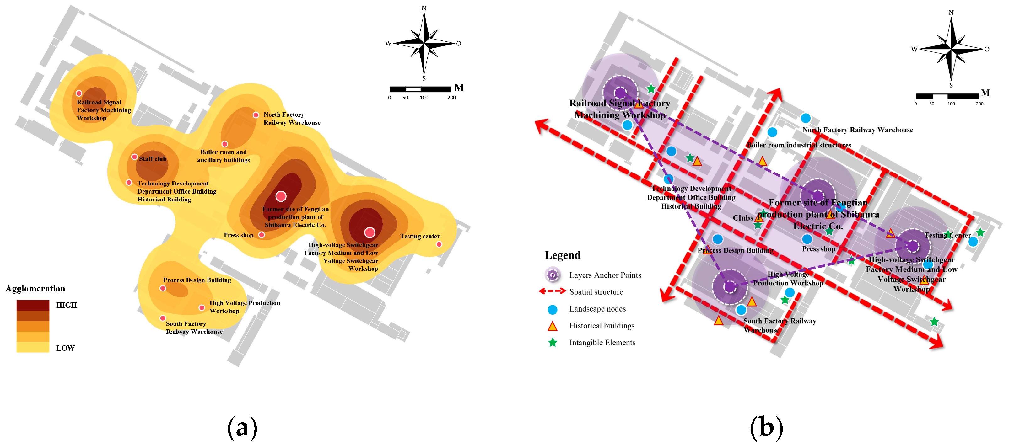
High-Voltage Switchgear Factory Historic District
The material carriers of the High-Voltage Switchgear Factory historic district form a composite layering pattern through the interaction of the three-dimensional elements of the point, line, and surface. The point-like anchorage, which comprises the high-voltage switch workshop, cooling tower, and chimney group, serves as the core of this layering pattern. The linear skeleton, on the other hand, relies on the railroad line and the road network of the factory to expand, connecting the scattered industrial anchors to form the functional conduction of “productive skeleton–living vein”. The surface matrix forms the production texture with the layout of rows and columns of production workshops (Figure 25).
(7)
Imperial Temple Historic District
The layering pattern of the Imperial Temple historic district is driven by religious culture as the core, forming the layering pattern of “anchoring by two temples”. Sisheng Temple and Taiping Temple (Sibe family temple) comprise the dual-core anchoring point. Taiping Temple adopts the courtyard layout, while Sisheng Temple forms the radial layer with the central axis symmetrical official layout. The landscape structures at the east and west entrances serve a dual function: they demarcate the spatial boundaries and extend the visual scope of the landscape axis by serving as focal points. The layering of the city’s cultural fabric is facilitated by the spatial organization of the dual-core anchoring points, which exhibits a layering law that is centralized, diversified, and adaptive (Figure 26).
(8)
Santaizi Workers’ Village Historic District
The layering pattern of the historic district of the Sandaizi Workers’ Village is characterized by a triangular layering, with the residential group on Baihuashan Road, the residential group on Songshan Road, and the Shenfei Cultural Palace serving as the anchor points. This results in a stable triangular structure of “residence–culture–residence”, thereby constructing a dynamic evolution of the historic landscape through functional complementarity and spatial linkage. The construction of a dynamically evolving historical landscape is facilitated by functional complementarity and spatial linkage. The residential group on Baihuashan Road and the residential group on Songshan Road are notable exemplars of Soviet-style workers’ houses, featuring rows of red-brick buildings and enclosed courtyard designs. These structures embody the collective residential culture of the planned economy era. The Shenfei Cultural Palace, as the core node of culture, has become the symbol of workers’ spiritual life with its Soviet eclectic architectural style and internal large-span auditorium space (Figure 27).
(9)
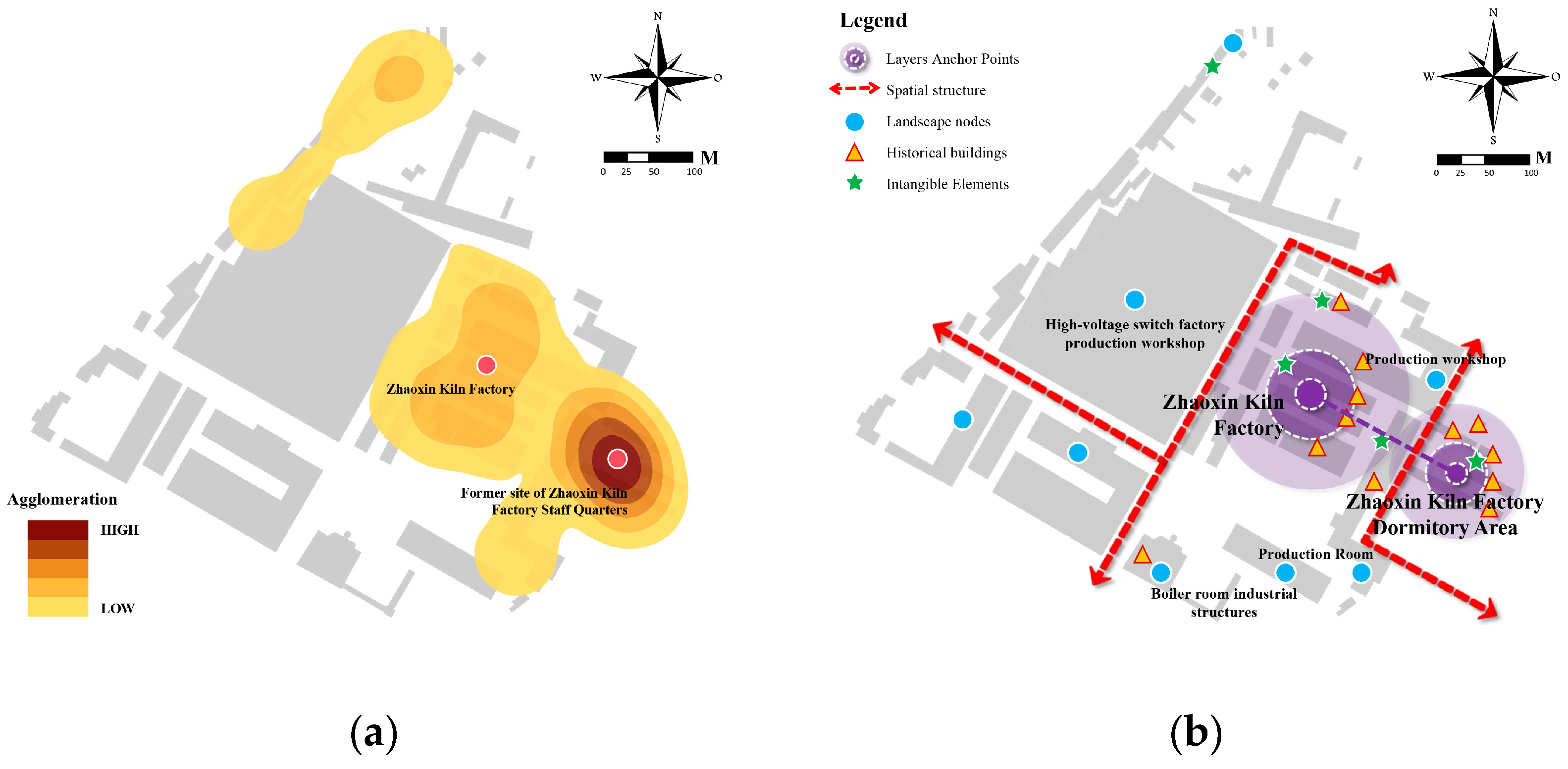
Zhaoxin Kiln Factory Historic District
The Zhaoxin Kiln Factory historic district features kiln workshops and chimney stacks as its core production anchors, with rows upon rows of brick and wooden factory buildings forming a homogeneous grid texture that reflects the orderliness of early industrial production. The dormitory area utilizes single-story red-brick houses as the focal point for residential life, employing a row-and-column layout to establish a cohesive living unit. These elements are interconnected by the factory area’s thoroughfares, thereby establishing a functional conduit between “production and living” (Figure 28).
(10)
Hongmei MSG Factory Historic District
The Hongmei MSG factory is characterized by a linear distribution of industrial buildings along a railroad axis, including a factory complex comprising a series of fermentation workshops, raw materials warehouses, and other industrial buildings. The factory’s linear layout is defined by towering fermentation tanks and a dense network of industrial pipelines, which together create a homogeneous production matrix. This configuration is further reinforced by a closed-wall system and a network of grid roads, contributing to a pronounced functional specificity within the industrial infrastructure (Figure 29).

4. Discussion

4.1. From Law to Application: Absolute Protection Combined with Organic Renewal

In accordance with the prevailing principles of historical neighborhood evolution, it is imperative to ensure the comprehensive protection of the core anchors and structural elements while facilitating the organic renewal of associated components. The systematic framework of “rigid protection of anchor points–flexible iteration of related domains” is fundamentally a synergistic integration of value stratification and dynamic adaptation of the layered structure. Absolute protection entails safeguarding the core anchor points of historical layers. This is achieved by establishing irreversible technical boundaries and implementing a living monitoring mechanism. Such measures ensure the integrity of both material and immaterial attributes, prevent the dissolution of layer information caused by function replacement, and maintain spatial–temporal continuity of cultural heritage values. Conversely, organic renewal emphasizes the correlation elements within the layered system and implements adaptive transformation within the constraints of spatial genetic topological relations [49]. The translation of traditional architectural vocabulary to reconstruct modern functional carriers, in conjunction with the implementation of a “prototype derivation” strategy to transform historical features into contemporary design parameters, is instrumental in preserving the density and rhythm of the street texture and the historical perception of façade materials. This approach also facilitates the integration of a hidden technical system that aligns with contemporary needs. In the process of renewal, it is necessary to establish a catalytic mechanism of “priority revitalization of core points”, selecting nodes with low cultural sensitivity but strong spatial exemplification for innovative experiments, and forming a progressive renewal path through the parametric connection of the old and new interfaces.

4.2. Theoretical Paradigm Shift: From Static Conservation to Dynamic Layered Cognition

The conservation and renewal of historic districts must overcome the cognitive limitations of traditional “frozen” conservation and transition to the paradigm of “dynamic accumulation”. The essence of historic districts is a complex system of continuous interaction of natural, humanistic, and social elements in multiple spatial and temporal dimensions. Its value is reflected not only in the integrity of material remains but also in the logic of superposition of spatial genes and the inheritance mechanism of cultural memories in different historical periods [50]. The paradigm shift from the “fragmentary intergenerational analysis” to the “continuous layer accumulation analysis” is pivotal in recognizing historic districts as “living texts” that embody the reproduction of social relations, spatial form succession, and collective memory reconstruction. It is imperative to acknowledge the historic district as a “living text” that encompasses the reproduction of social relations, the evolution of spatial form, and the reconstruction of collective memory. Consequently, the conservation paradigm must transition from the preservation of a single material form to a dynamic balance of multiple values. This shift necessitates an emphasis on the carrier transformation law of cultural genes in the layered interface, as well as the reorganization logic of functional iteration and social network in different historical stages. The construction of a laminar analysis model will facilitate the systematic revelation of the self-organization law of the historic district as a complex adaptive system, thereby providing theoretical support for resolving the structural contradiction between preservation and renewal [51].

4.3. Innovation in Protection Mechanisms: Synergistic Governance of Hierarchical Systems and Dynamic Regulation

The protection of historic districts necessitates the implementation of a synergistic governance mechanism that incorporates “hierarchical identification, dynamic monitoring, and flexible control”. The construction of a hierarchical protection system is predicated on the law of stratification. Through the analysis of the spatial coupling relationship and the value weight of material carriers (point-like anchors, linear skeleton, and surface substrate), the core stratification zone (to protect the authenticity of historical genes), the buffer coordination zone (to maintain the continuity of the spatial structure), and the adaptive updating zone (to carry openness to the functional iteration) are defined, and differentiated management and control strategies are formed. Concurrently, a dynamic monitoring index system is introduced to incorporate elements such as integrity of the material form, functional adaptability, and social participation into the quantitative assessment framework. This establishes a two-way feedback mechanism of “protection effectiveness–renewal pressure” and realizes the transformation from rigid control to flexible regulation. The governance model undergoes a transition from a “technical rationality dominance” to a “shared governance by multiple subjects” model. A platform is established for the visualization and sharing of historical information, enhancing the institutionalized channels for community participation and fostering collaborative decision-making among the government, the market, the residents, and the professional forces. This facilitates the resolution of problems arising from rigid property rights, conflicts of interest, and value perception [52].

4.4. Sustainable Regeneration Pathways: Spatial Genetic Continuity and Functional Adaptive Iteration

The revitalization of historic districts should adhere to a sustainable approach, involving the identification of genes, the restoration of interfaces, and the promotion of functional symbiosis. The identification and continuation of spatial genes serve as the foundation. By extracting the spatial organization logic and architectural archetypal features that serve as cultural identifiers of historic districts and transforming them into contemporary design language, the spatial and temporal continuity of the spirit of the place is maintained [53]. The restoration of interfaces is pivotal, emphasizing the regulation of material carrier conversion nodes within layered interfaces. This approach facilitates the discernibility of historical layers by manipulating the coordination of spatial scale, material texture, and visual corridors [54]. The core objective of functional adaptation iteration involves the abandonment of the radical renewal mode of “functional replacement” and the exploration of gradient mixing and dynamic balance between old and new functions. This process establishes a symbiotic mechanism between historical functions and modern needs. In this process, digital technology (e.g., layer accumulation information model, social perception analysis) can provide accurate spatial gene decoding tools, while institutional innovation provides sustainable operation guarantee for functional iteration, and ultimately realizes the “resilient renewal” of historic districts, which perpetuates the cultural memory in the dynamic development, and stimulates the spatial vitality in the functional activation [55].

4.5. Revolutionizing Protection Thinking: Digital Enablement and Dynamic Protection

The protection of historic districts needs to break through the traditional static and fragmented thinking and turn to a systematic reconstruction based on the law of spatial and temporal accumulation and digital technology. The core of conservation is to regard the neighborhood as a “living stratum”, the value of which exists not only in the material remains but also in the dynamic continuity of functional iteration and cultural evolution [56]. By analyzing the law of historical layering, we can identify the stable core and variable boundary of spatial genes and cultural genes to establish a hierarchical control system, rigidly protecting the hardcore layer that carries the core values and flexibly updating the variable layer that adapts to development. At the same time, a multi-criteria decision-making analysis is introduced to quantify and analyze the core values. At the same time, multi-criteria decision analysis is introduced to quantitatively assess the priority of the protection elements, combined with a fuzzy approach to dealing with the conflict of historical values, community demands, and economic benefits, and transform the fuzzy semantics of “degree of preservation of authenticity” and “functional compatibility” into calculable decision-making parameters using the affiliation function [57,58]. The fuzzy semantics, such as “authenticity retention degree” and “functional compatibility”, are transformed into computable decision-making parameters through the subordinate function. Machine learning technology is used to deeply mine the spatial evolution data of neighborhoods and predict the long-term impacts of different intervention strategies, such as using a convolutional neural network to analyze historical image data, identify the pattern of landscape coordination, and generate update plans [59,60]. Through the paradigm of “digital empowerment + dynamic protection”, the spatial and temporal integrity of historical information can be maintained, while the social functions of the neighborhood can be activated, thus realizing the qualitative change of the protection from “morphological speciation” to “living inheritance”.

5. Conclusions

The present study is founded on the theory of the urban historic landscape. It proposes a progressive research path for analyzing the evolution law of historical neighborhoods. This path is based on the following elements: “historical area, spatial form, material carrier, and value characteristics”. Shenyang was selected as the object of empirical research. Through the research method of single-case embedded multi-scenarios and sub-cases, the kernel density analysis method, and the geometric illustration method, a systematic analysis of Shenyang’s historical neighborhoods’ layering law was carried out. The analysis reveals that the historical area dimension of Shenyang’s historic districts exhibits a layered evolution law of “single-core dominance–dual-core juxtaposition–fusion and collage–expansion and extension–multi-point radiation”. The spatial pattern is summarized as seven types of dynamic evolutionary laws, such as radiation, ring, triangle, and grid. The material carrier adheres to the conventional law of anchoring point-like elements and utilizing line-like elements as the skeletal structure and surface-like elements as the substrate. The value cascade, in contrast, is characterized by a symbiotic mechanism of centralization, diversification, and self-adaptation, thereby establishing a logical correlation of synergistic evolution between the transmission of historical memory and functional iteration.
This study contributes to the theoretical framework of the theory of the Historic Urban Landscape (HUL) by proposing the concept and method of “Layered Evolution Law”. This approach offers a novel approach to the localized application of the HUL theory. The law of accumulation, as elucidated by the analysis of “time slicing”, underscores the necessity of preserving historic districts by ensuring the continuity of their physical form, the reorganization of their social networks, and the enhancement of collective memory. This methodological approach provides a framework for addressing the dilemma of “fractured layers”. At the methodological level, quantitative analysis overcomes the limitations of previous qualitative research. The integration of spatial morphology and historical geographic information analysis methods was employed in the study to reveal the spatial and temporal aggregation effect of historical resources in historic districts. From a pragmatic standpoint, the study puts forth a hierarchical conservation framework and a dynamic balancing mechanism, thus offering an operational solution for heritage conservation in urban renewal. It is imperative to recognize the significance of the differentiated control of the core accumulation zone (original protection), buffer coordination zone (structural continuation), and adaptive renewal zone (functional iteration) in achieving a dynamic balance between the inheritance of historical values and the needs of urban development. This approach is instrumental in effectively activating the contemporary vitality of the historic district.
The analytical framework of “historical area–spatial pattern–material carrier–value characteristics” developed in this study can be applied to cases with obvious historical stratification characteristics, such as modern colonial cities and industrial heritage gathering areas. However, the following shortcomings must be noted: (1) Shenyang, as a paradigmatic city in transition within the industrial civilization paradigm, possesses a distinctive historical background, including the Manchurian Railway Subsidiary. This historical element may serve to attenuate the general applicability of the conclusions derived from the study. Secondly, the morphology of geometrical diagrammatic method analysis has the capacity to reveal the law of spatial evolution. However, it is difficult to quantify non-material accumulation, such as the reorganization of social networks and the continuation of collective memory. Thirdly, the hierarchical protection framework faces institutional obstacles in its implementation, and the technical solutions must be synchronized with the innovation of the governance system.
In subsequent research, advancements may be made in the following domains: The initial step involves the construction of interdisciplinary quantitative characterization models of layers, integrating spatial syntax, social network analysis, and memory map technology, and constructing a coupled analysis system of material and immaterial elements. The subsequent step involves the exploration of multi-scale synergistic mechanisms and the establishment of a coherent research path for the identification of architectural monolithic layer genes, analysis of the evolution law of neighborhoods, and the continuation of the city’s cultural lineage. Thirdly, the promotion of protection technology integration and innovation is imperative, as is the application of machine learning and other methods to the prediction of stratum breaks, historical image identification, and historical landscape identification. Fourthly, the research on adaptive governance must be deepened, and a differentiated implementation mode of stratum protection for heritage sites with different property rights structures and cultural types must be established.

Author Contributions

Conceptualization, Y.W. and D.X.; methodology, Y.W.; software, Y.W.; validation, C.J., T.W. and D.X.; formal analysis, Y.W.; investigation, Y.W., T.W. and D.X.; resources, C.J.; data curation, Y.W. and T.W.; writing—original draft preparation, Y.W.; writing—review and editing, C.J.; visualization, Y.W.; supervision, C.J.; project administration, C.J. and D.X.; funding acquisition, C.J. All authors have read and agreed to the published version of the manuscript.

Funding

This research was funded by the Special Funds Program for Basic Research Operating Expenses of Central Universities (Grant No. 82232013).

Data Availability Statement

The data are available from the corresponding author upon reasonable request.

Conflicts of Interest

The authors declare no conflicts of interest.

References

  1. Ginzarly, M.; Houbart, C.; Teller, J. The Historic Urban Landscape approach to urban management: A systematic review. Int. J. Herit. Stud. 2019, 25, 999–1019. [Google Scholar] [CrossRef]
  2. Bandarin, F.; van Oers, R. The Historic Urban Landscape: Managing Heritage in an Urban Century; John Wiley & Sons: Hoboken, NJ, USA, 2012. [Google Scholar]
  3. Santander, A.A.; Garai-Olaun, A.A.; De la Fuente Arana, A. Historic urban landscapes: A review on trends and methodologies in the urban context of the 21st century. Sustainability 2018, 10, 2603. [Google Scholar] [CrossRef]
  4. Taylor, K. The Historic Urban Landscape paradigm and cities as cultural landscapes. Challenging orthodoxy in urban conservation. Landsc. Res. 2016, 41, 471–480. [Google Scholar] [CrossRef]
  5. Cody, J.; Siravo, F. Historic Cities: Issues in Urban Conservation; Getty Conservation Institute: Los Angeles, CA, USA, 2019. [Google Scholar]
  6. Xie, S.Y.; Gu, K.; Zhang, X.L. Urban conservation in China in an international context: Retrospect and prospects. Habitat Int. 2020, 95, 102098. [Google Scholar] [CrossRef]
  7. Bonfantini, G.B. Historic Urbanscapes for Tomorrow, Two Italian Cases:Genoa and Bologna. Eur. Spat. Res. Policy 2015, 22, 57–71. [Google Scholar] [CrossRef]
  8. Chen, S.J. The Concept of Historic Authenticity and Its Methdology for Preservation of Historic Urban Areas in Chinese Contexts; Univ Pennsylvania Press: Philadelphia, PA, USA, 2014. [Google Scholar]
  9. Fan, L. International influence and local response: Understanding community involvement in urban heritage conservation in China. Int. J. Herit. Stud. 2014, 20, 651–662. [Google Scholar] [CrossRef]
  10. Geppert, A. Planning systems facing heritage issues in Europe: From protection to management, in the plural interpretations of the values of the past. Eur. Spat. Res. Policy 2015, 22, 5–8. [Google Scholar]
  11. Jiang, J.; Zhou, T.; Han, Y.; Ikebe, K. Urban heritage conservation and modern urban development from the perspective of the historic urban landscape approach: A case study of Suzhou. Land 2022, 11, 1251. [Google Scholar] [CrossRef]
  12. Aysegul, K.T. Method for assessment of the historical urban landscape. Procedia Eng. 2016, 161, 1697–1703. [Google Scholar] [CrossRef]
  13. Pereira Roders, A. The historic urban landscape approach in action: Eight years later. In Reshaping Urban Conservation: The Historic Urban Landscape Approach in Action; Springer: Berlin/Heidelberg, Germany, 2019; pp. 21–54. [Google Scholar]
  14. Zancheti, S.M.; Loretto, R.P. Dynamic integrity: A concept to historic urban landscape. J. Cult. Herit. Manag. Sustain. Dev. 2015, 5, 82–94. [Google Scholar] [CrossRef]
  15. Zeayter, H.; Mansour, A.M.H. Heritage conservation ideologies analysis–Historic urban Landscape approach for a Mediterranean historic city case study. HBRC J. 2018, 14, 345–356. [Google Scholar] [CrossRef]
  16. Whitehand, J. Urban morphology and historic urban landscapes. World Herit. Pap. 2010, 27, 35–44. [Google Scholar]
  17. Grazuleviciute-Vileniske, I.; Seduikyte, L.; Daugelaite, A.; Rudokas, K. Links between heritage building, historic urban landscape and sustainable development: Systematic approach. Landsc. Archit. Art 2020, 17, 30–38. [Google Scholar] [CrossRef]
  18. Turner, M.; Singer, R. Researching and mapping the historic urban landscape. In Reconnecting the City: The Historic Urban Landscape Approach and the Future of Urban Heritage; Wiley-Blackwell: Hoboken, NJ, USA, 2014; pp. 301–315. [Google Scholar]
  19. Liu, T.H.; Butler, R.J.; Zhang, C.Y. Evaluation of public perceptions of authenticity of urban heritage under the conservation paradigm of Historic Urban Landscape: A case study of the Five Avenues Historic District in Tianjing, China. J. Archit. Conserv. 2019, 25, 228–251. [Google Scholar] [CrossRef]
  20. Prabowo, B.N.; Pramesti, P.U.; Ramandhika, M.; Sukawi, S. Historic urban landscape (HUL) approach in Kota Lama Semarang: Mapping the layer of physical development through the chronological history. IOP Conf. Ser. Earth Environ. Sci. 2020, 1, 402. [Google Scholar] [CrossRef]
  21. Jiang, J.; Zang, T.; Xing, J.; Ikebe, K. Spatial distribution of urban heritage and landscape approach to urban contextual continuity: The case of Suzhou. Land 2023, 12, 150. [Google Scholar] [CrossRef]
  22. Li, X.X.; Ye, Z. Urban Morphology and Historical Urban Landscape Conservation and Management. In Conserving and Managing Historical Urban Landscape: An Integrated Morphological Approach; Springer: Singapore, 2023; pp. 7–32. [Google Scholar]
  23. Lynch, K. The Image of the City; MIT Press: Cambridge, MA, USA, 1964. [Google Scholar]
  24. Qi, K. Morphology of the City; Southeast University Press: Nanjing, China, 2001. [Google Scholar]
  25. Liu, Y.F. The Anchoring-Layering Theory: For a Better Understanding and Conservation of Historic Urban Landscape. Ph.D. Thesis, Tsinghua University, Beijing, China, 2014. [Google Scholar]
  26. Ding, S.S. A Study in the Construction of a City’s Historical and Culture Landscape Network, Based on the Patch-Corridor Theory: Take Traditional-Landscape-Clustered Area in Hangzhou’s Old Town as an Example; D. Theory; Zhejiang University: Zhejiang, China, 2012. [Google Scholar]
  27. Li, H.P.; Yang, N. Study on the Overall Protection Framework of Historic Towns in Southwest Moutainous Area in the Perspective of Historic Urban Landscape. Urban Dev. Stud. 2018, 25, 66–73. [Google Scholar]
  28. Fu, S.G.; Shen, B.J. Study on the “Folding” Method of Historic Urban Landscapes: A Case of the Historic Urban Landscape of Tanggong Market in Luoyang. Urban. Archit. 2023, 20, 146–149. [Google Scholar]
  29. Xiao, J.; Cao, K. Characteristic Extraction and Layering Interpretation of Historic Urban Landscape in Ü-Tsang. Chin. Landsc. Archit. 2019, 35, 101–106. [Google Scholar]
  30. Cai, R. Study on Adaptation Protection for Historic Blocks from the Perspective of Layering Rules Analysis: A Case Study of Ciqikou Historic Block, Chongqing; Chongqing University: Chongqing, China, 2020. [Google Scholar]
  31. Pei, Y.; Yang, R.; Dang, A.R. Historic Layering Process Interpretation and Value Assessment of the Ancient City of Yulin Based on Historic Urban Landscape Approach. Urban Dev. Stud. 2022, 29, 128–136. [Google Scholar]
  32. Feng, C.Z.Y. Layering, Characteristic and Inheritance:The Exploration on the Protectionand Renewal Strategy of Kuixingxiang Block in Yuncheng. Chin. Overseas Archit. 2023, 09, 61–68. [Google Scholar]
  33. Xiao, J.; Cao, K.; Li, H.P. The Evolution Laws and Layering Management Methodologies of Historic Urban Landscape. Urban Dev. Stud. 2018, 25, 59–69. [Google Scholar]
  34. Xiao, J.; Li, H.P.; Cao, K. The Regional Features and Layering Processes of Historical Urban Landscape in Lhasa. Archit. J. 2017, 9, 58–63. [Google Scholar]
  35. Kuitert, W. Urban landscape systems understood by geo-history map overlay. J. Landsc. Archit. 2013, 8, 54–63. [Google Scholar] [CrossRef]
  36. Cai, R.Z.; Nasu, S. Adopting the ‘historic layering’ concept from the Historic Urban Landscape approach as a methodological framework for urban heritage conservation. Int. J. Herit. Stud. 2025, 31, 573–591. [Google Scholar] [CrossRef]
  37. Bushmakina, Y.V.; Balyberdina, P.A.; Dmitrieva, M.K.; Gogoleva, M.V. The use of GIS for studying cultural heritage and historical urban landscape: The case of Perm and Usolie (Russia). Ge-Conservacion 2017, 11, 26. [Google Scholar]
  38. Tian, H.; Han, Z.; Xu, W.; Liu, X.; Qiu, W.; Li, W. Evolution of historical urban landscape with computer vision and machine learning: A case study of Berlin. J. Digit. Landsc. Archit 2021, 6, 436–451. [Google Scholar]
  39. Wang, Y.; Jin, C.; Xu, D.; Wang, T.; Wang, B. Analysis of Multi-Dimensional Layers in Historic Districts Based on Theory of the Historic Urban Landscape: Taking Shenyang Fangcheng as an Example. Land 2024, 13, 1736. [Google Scholar] [CrossRef]
  40. Pang, S.J.; Li, N.H.; Lin, Y.Q.; Zhao, X. The Revealing of “Layers”: The Thoughts on the Preparation of Urban Design Guidelines for Windscape Control of Streets Along the Central Axis in Beijing. Beijing Plan. Rev. 2019, 1, 44–50. [Google Scholar]
  41. Yang, J. Study on the Characteristic Recognition and Layered Cognition of Historic Urban Landscape in Nanjing. J. Hum. Settl. West China 2023, 38, 117–124. [Google Scholar]
  42. Bai, X.; Jiao, X.; Sakai, T.; Xu, H. Mapping the past with historical geographic information systems: Layered characteristics of the historic urban landscape of Nanjingg, China, since the Ming Dynasty (1368–2024). Herit. Sci. 2024, 12, 283. [Google Scholar] [CrossRef]
  43. Wu, C.H.; Li, G.P.; Li, Y.T.; Pu, Y.; Zhang, Y.Z. A Review of Research on Strategies and Methods for the Revitalization of Urban Historic Districts. In IOP Conference Series: Earth and Environmental Science; IOP Publishing: Bristol, UK, 2022; Volume 5, p. 1101. [Google Scholar]
  44. Choi, S.; Walter, R.J.; Chalana, M. Walter, and Manish Chalana. Untangling our checkered past: Investigating the link between local historic district designation and spatial segregation history. Cities 2025, 158, 105621. [Google Scholar] [CrossRef]
  45. Vignali, E.B. Historic Districts: Preserving the Old with the Compatible New. William Mary Law Rev. 2017, 59, 345. [Google Scholar]
  46. Yung, E.H.K.; Chan, E.H.W.; Xu, Y. Sustainable development and the rehabilitation of a historic urban district–Social sustainability in the case of Tianzifang in Shanghai. Sustain. Dev. 2014, 22, 95–112. [Google Scholar] [CrossRef]
  47. Zhou, T.; Zhou, Y.L.; Liu, G.W. Comparison of critical success paths for historic district renovation and redevelopment projects in China. Habitat Int. 2017, 67, 54–68. [Google Scholar] [CrossRef]
  48. Zhang, H.; Wang, F.; Guo, F.; Cai, J.; Dong, J. Urban built heritage protection and realistic dilemmas: The development process, protection system, and critical thinking of historic districts in Dalian. Built Herit. 2023, 7, 25. [Google Scholar] [CrossRef]
  49. Zhang, M.; Zhang, Y.; Fang, X.; Wang, X. A 3D spatial diagnostic framework of sustainable historic and cultural district preservation: A case study in Henan, China. Buildings 2023, 13, 1344. [Google Scholar] [CrossRef]
  50. Yang, X.; Shen, J. Integrating historic landscape characterization for historic district assessment through multi-source data: A case study from Hangzhou, China. npj Herit. Sci. 2025, 13, 33. [Google Scholar] [CrossRef]
  51. Pankakoski, T. From historical structures to temporal layers: Hans Freyer and conceptual history. Hist. Theory 2020, 59, 61–91. [Google Scholar] [CrossRef]
  52. Schulz-Forberg, H. The Spatial and Temporal Layers of Global History: A Reflection on Global Conceptual History through Expanding Reinhart Koselleck’s “Zeitschichten” into Global Spaces. Hist. Soc. Res. 2013, 38, 40–58. [Google Scholar]
  53. Weiss, L.M. Informal Settlements and Urban Heritage Landscapes in South Africa. J. Soc. Archaeol. 2014, 14, 3–25. [Google Scholar] [CrossRef]
  54. Ebejer, J. Values as a base for the viable adaptive reuse of fortified heritage in urban contexts. Muzeológia A Kultúrne dedičstvo 2019, 11, 41–72. [Google Scholar] [CrossRef]
  55. Wang, S.; Zhang, J.; Wang, F.; Dong, Y. How to achieve a balance between functional improvement and heritage conservation? A case study on the renewal of old Beijing city. Sustain. Cities Soc. 2023, 98, 104790. [Google Scholar] [CrossRef]
  56. Wang, H.J.; Zeng, Z.T. A multi-objective decision-making process for reuse selection of historic buildings. Expert Syst. Appl. 2010, 37, 1241–1249. [Google Scholar] [CrossRef]
  57. Camatti, N.; di Tollo, G.; Gastaldi, F.; Camerin, F. Cultural heritage reuse applying fuzzy expert knowledge and machine learning: Venice’s fortresses case study. Reg. Stud. Reg. Sci. 2025, 12, 225–251. [Google Scholar] [CrossRef]
  58. Yau, Y. Multi-criteria decision making for urban built heritage conservation: Application of the analytic hierarchy process. J. Build. Apprais. 2009, 4, 191–205. [Google Scholar] [CrossRef]
  59. Pinero, I.; San-Jose, J.T.; Rodriguez, P.; Losanez, M.M. Multi-criteria decision-making for grading the rehabilitation of heritage sites. Application in the historic center of La Habana. J. Cult. Herit. 2017, 26, 144–152. [Google Scholar] [CrossRef]
  60. Andria, J.; di Tollo, G.; Pesenti, R. A heuristic fuzzy algorithm for assessing and managing tourism sustainability. Soft Comput. 2020, 24, 4027–4040. [Google Scholar] [CrossRef]
Figure 1. A logic diagram of the research framework (Source: drawing by W.Y.).
Land 14 01029 g001
Figure 2. Shenyang location map (Source: drawing by W.Y., Administrative boundary data from the Resource Environmental Science Data Registry and Publishing System (REDS)).
Land 14 01029 g002
Figure 3. Shenyang historic district layering process (Source: drawing by W.Y., base map from Shenyang Municipal Bureau of Natural Resources).
Land 14 01029 g003
Figure 4. Shenyang historic district layering process (Source: drawing by W.Y., Historical map from the Shenyang Archives).
Land 14 01029 g004
Figure 5. The layered laws of regional dimensions of Shenyang historic districts: (a) single-core dominance; (b) dual-core parallelism; (c) fusion collage; (d) extended extension; (e) multi-point radiation. (Source: drawing by W.Y., base map from Shenyang Municipal Bureau of Natural Resources).
Land 14 01029 g005
Figure 6. Political buildings as anchor points in the Shenyang historic district: (a) Dazheng Hall of the Shenyang Imperial Palace; (b) Eastern Province; (c) Zhang’s Marshal’s Mansion, the Great Green House; (d) Mantetsu Regional Office. (Source: Photographs by W.Y.).
Land 14 01029 g006
Figure 7. The railway station as the anchor point in the Shenyang historic district: (a) Shenyang Station; (b) Liaoning Main Station; (c) Shenyang East Station. (Source: (a) Photographs by W.Y.; (b,c) from Shenyang Cultural Conservation Association).
Land 14 01029 g007
Figure 8. Shenyang historic district anchor point of the palace of culture: (a) Tiexi Workers’ Cultural Palace; (b) Santaizi Workers’ Cultural Palace; (c) Harmony Road Workers’ Cultural Palace; (d) Dongji Cultural Palace. (Source: (a) from Shenyang Archives; (bd) Photographs by W.Y.).
Land 14 01029 g008
Figure 9. Religious buildings as anchor points in the Shenyang historic district: (a) Chang’an Temple; (b) Imperial Temple, Sibe Family Temple; (c) Bonjour Temple, Ci’en Temple, Great Buddha Temple. (Source: Photographs by W.Y.).
Land 14 01029 g009
Figure 10. Mansion houses as anchor points in the Shenyang historic district: (a) Zhang’s Handsome Mansion; (b) Yu Jichuan Mansion; (c) Tang Yulin Mansion; (d) Zhang Zuoxiang Mansion. (Source: Photographs by W.Y.).
Land 14 01029 g010
Figure 11. Production workshops as anchor points in the Shenyang historic district: (a) former foundry workshop; (b) former high-voltage switch factory workshop; (c) MSG factory fermentation workshop; (d) workshop of the automobile manufacturing factory. (Source: Photographs by W.Y.).
Land 14 01029 g011
Figure 12. Landscape structures as anchoring points in the Shenyang historic district: (a) Square Gate Tower; (b) Mao Zedong Statue in Zhongshan Square; (c) Stone Gate Tower in North Market; (d) Stone Gate Tower in Dafosi Temple. (Source: Photographs by W.Y.).
Land 14 01029 g012
Figure 13. Industrial structures as anchor points in the Shenyang historic district: (a) cooling towers; (b) gantry cranes; (c) chimneys and water towers; (d) transportation piping. (Source: Photographs by W.Y.).
Land 14 01029 g013
Figure 14. Layering regularity with a typical road as a skeleton: (a) Zhongshan Road; (b) Zhong Street, formerly Siping Street. (Source: Photographs by W.Y.).
Land 14 01029 g014
Figure 15. Layered regularity with railroad line as a skeleton: (a) Refractory Material Factory historic district; (b) High-Voltage Switch Factory historic district; (c) Hongmei MSG Factory historic district. (Source: Drawing by W.Y.).
Land 14 01029 g015
Figure 16. Layered regularity with view corridors as a skeleton: (a) Zhongshan Road Sightline Corridor; (b) Fangcheng Sightline Corridor. (Source: Photographs by W.Y.).
Land 14 01029 g016
Figure 17. Layering regularity with a spatial texture as a substrate: (a) axial grouping; (b) symmetrical grouping; (c) row and column grouping; (d) scattered grouping. (Source: Photographs by W.Y.).
Land 14 01029 g017
Figure 18. Layering regularity with a spatial texture as a substrate: (a) tic-tac-toe pattern; (b) radial pattern; (c) symmetrical pattern; (d) irregular block pattern. (Source: drawing by W.Y., base map from Google Maps).
Land 14 01029 g018
Figure 19. (ac) An illustration of the law of layers of value (Source: drawing by W.Y.).
Land 14 01029 g019
Figure 20. Analysis of layering patterns in the Fangcheng historic district: (a) kernel density analysis; (b) graphical analysis. (Source: drawing by W.Y.).
Land 14 01029 g020
Figure 21. Analysis of layering patterns in the Zhongshan Road historic district: (a) kernel density analysis; (b) graphical analysis. (Source: drawing by W.Y.).
Land 14 01029 g021
Figure 22. Analysis of layering patterns in the Tiexi Workers’ Village historic district: (a) kernel density analysis; (b) graphical analysis. (Source: drawing by W.Y.).
Land 14 01029 g022
Figure 23. Analysis of layering patterns in the Tangzi Temple historic district: (a) kernel density analysis; (b) graphical analysis. (Source: drawing by W.Y.).
Land 14 01029 g023
Figure 24. Analysis of layering patterns in the Refractory Factory historic district: (a) kernel density analysis; (b) graphical analysis. (Source: drawing by W.Y.).
Land 14 01029 g024
Figure 25. Analysis of layering patterns in the High-Voltage Switchgear Factory historic district: (a) kernel density analysis; (b) graphical analysis. (Source: drawing by W.Y.).
Land 14 01029 g025
Figure 26. Analysis of layering patterns in the Imperial Temple historic district: (a) kernel density analysis; (b) graphical analysis. (Source: drawing by W.Y.).
Land 14 01029 g026
Figure 27. Analysis of layering patterns in the Santaizi Workers’ Village historic district: (a) kernel density analysis; (b) graphical analysis. (Source: drawing by W.Y.).
Land 14 01029 g027
Figure 28. Analysis of layering patterns in the Zhaoxin Kiln Factory historic district: (a) kernel density analysis; (b) graphical analysis. (Source: drawing by W.Y.).
Land 14 01029 g028
Figure 29. Analysis of layering patterns in the Hongmei MSG Factory historic district: (a) kernel density analysis; (b) graphical analysis. (Source: drawing by W.Y.).
Land 14 01029 g029
Table 1. Statistics of Shenyang historic districts.
No.NameLocationCategorizationCausality
FunctionPeriodProtection Stage
1Fangcheng Historic DistrictShenhe districtAdministrative function-ledAncientUpdatingHistorical and cultural district
2Zhongshan Road Historic DistrictHeping districtAdministrative function-ledCapitalist timesUpdatingHistorical and cultural district
3Tiexi Workers’ VillageTiexi districtResidential function-ledModernityUpdatingHistorical and cultural district
4High-Voltage Switchgear FactoryTiexi districtIndustrial heritage-ledCapitalist timesUpdatingIndustrial heritage
historic sites
5Refractory Material FactoryTiexi districtIndustrial heritage-ledCapitalist timesUpdatingIndustrial heritage
historic sites
6Tangzi Street Historic DistrictDadong districtHybrid functionalAncientUpdatingHistorical area
7Zhaoxin Kiln FactoryDadong districtIndustrial heritage-ledCapitalist timesNot updatedIndustrial heritage
historic sites
8Santaizi Workers’ VillageHuanggu districtResidential function-ledModernityUpdatingIndustrial heritage
historic sites
9Imperial Ancestral TempleHeping districtCultural function-ledAncientUpdatedHistorical area
10Jiaxing Street Historic DistrictHeping districtResidential function-ledCapitalist timesUpdatingHistorical area
11Linquan Road Historic DistrictHeping districtResidential function-ledCapitalist timesUpdatingHistorical area
12Bajing Street Historic DistrictHeping districtHybrid functionalCapitalist timesUpdatingHistorical area
13Xiguan Historic DistrictShenhe districtCultural function-ledAncientNot updatedHistoric style district
14Jiuruxiang Historic DistrictShenhe districtResidential function-ledCapitalist timesNot updatedHistorical area
15Ci’en Temple Historic DistrictShenhe districtCultural function-ledAncientUpdatingHistorical area
16Harmony Road Workers’ VillageDadong districtResidential function-ledModernityNot updatedIndustrial heritage
historic sites
17East Tower Historic DistrictDadong districtIndustrial heritage-ledAncientUpdatingHistoric style district
18Old Longkou WineryDadong districtIndustrial heritage-ledAncientUpdatingIndustrial heritage
historic sites
19Automobile FactoryShenhe districtIndustrial heritage-ledModernityNot updatedIndustrial heritage
historic areas
20Shenyang Aircraft FactoryHuanggu districtIndustrial heritage-ledCapitalist timesNot updatedIndustrial heritage
historic areas
21Dongji Cultural PalaceDadong districtHybrid functionalCapitalist timesNot updatedIndustrial heritage
historic areas
22Dongji FactoryDadong districtIndustrial heritage-ledCapitalist timesNot updatedIndustrial heritage
historic areas
23Prisoner of War Camp Historic DistrictDadong districtIndustrial heritage-ledCapitalist timesUpdatedIndustrial heritage
historic areas
24Mint Historic DistrictDadong districtIndustrial heritage-ledAncientNot updatedIndustrial heritage
historic areas
25Hongmei Monosodium Glutamate FactoryTiexi districtIndustrial heritage-ledCapitalist timesUpdatedIndustrial heritage
historic areas
26West Tower Historic DistrictHeping districtCultural function-ledAncientUpdatingHistoric style district
27Nine Trips House Historic DistrictHeping districtResidential function-ledCapitalist timesNot updatedHistoric style district
28Labor Road Historic DistrictDadong districtResidential function-ledCapitalist timesNot updatedHistoric style district
29North Daying Historic DistrictDadong districtHybrid functionalCapitalist timesUpdatingHistoric style district
30East Trade Center Historic DistrictDadong districtIndustrial heritage-ledCapitalist timesUpdatedIndustrial heritage
historic areas
Table 2. Spatial layering laws of Shenyang historical districts.
TypologyInterpretation CharacteristicIllustration
RadialRadial refers to a cascading pattern of spatial organization and functional areas expanding radially outward from a center. The center of this pattern typically functions as a node of historical or functional importance, such as an administrative center, a religious site, or a market.(1) Central node: usually the earliest building or functional area in the historic district, of high heritage value.
(2) Radial road network: taking the center as the starting point and extending in all directions, connecting the surrounding functional areas and building clusters.
(3) Level-by-level expansion: space and functions gradually accumulate from the core area to the outer layer, and the layer-by-layer effect gradually diminishes.
Land 14 01029 i001
ToroidalThe toroidal type is characterized by the district’s concentric layered structure, wherein the outer ring typically delineates the district’s boundaries, surrounding important nodes or areas, and reflecting the trajectory of the city’s development and expansion in the form of multiple ring layers.(1) Continuous boundary: the ring element is usually the boundary zone of the historic district, regular and continuous, reacting to the functional areas within.
(2) Layer-by-layer expansion: each layer of the ring represents the expansion and functional change of the district over time.
(3) Transportation and functional radiation: The transportation system and functional areas are dispersed from the outside to the inside, forming multiple concentric rings.
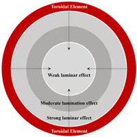
Land 14 01029 i002
Trigonom-etryThe concept of triangular layering pertains to the spatial configuration and allocation of functional zones within the historic district, with numerous anchoring points serving as the nucleus. This configuration gives rise to a stable triangular spatial configuration, characterized by interactions and interconnections between the anchoring points.(1) Multiple anchor points: usually important historical buildings, public facilities, or transportation hubs, forming key nodes in the space.
(2)Triangular layout: the connection between different anchor points forms a triangular division of functional areas and a transportation network.
(3) Complementarity between anchors: different functional areas are distributed around the anchors and are interconnected to build a layered structure of the district.
Land 14 01029 i003
MultilateralA polygonal type is defined as a form of the district that exhibits a complex polygonal structure, which is typically formed as a result of a combination of multiple significant nodes and complex topographic and functional demands.(1) Irregular boundaries: irregular polygonal spatial organization due to the presence of multiple anchor points or topographic constraints.
(2) Polycentric structure: multiple core areas may exist, resulting in a polygonal development in the distribution of the district’s historic space.
(3) Interlocking functional blocks: different functional areas are interlaced and distributed in the polygonal structure, forming a complex spatial layering.
Land 14 01029 i004
LinearThe term “linear” is employed to denote the spatial layering pattern of development in a historic district along a linear axis. This development is typically closely associated with natural geographic features (e.g., rivers), transportation routes (e.g., railroads, roads), and visual corridors.(1) Distribution along a line: the functions and buildings of a district are distributed along a major axis with a tendency to expand linearly.
(2) Types of axes: axes may be historically important transportation routes, view corridors, or natural geographic boundaries.
(3) Functional tandem: different functional areas along a linear axis are connected through transportation relationships.
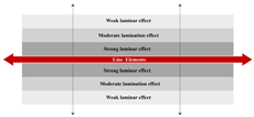
Land 14 01029 i005
Lattice
-type
The concept of grid-type layer law refers to the spatial organization of the historic district, which exhibits a regular or semi-regular grid-like layout, reflecting the principles of socialist construction and accentuating a sense of order and solemnity.(1) Regular street network: the district presents a square network of roads and streets, with buildings and functional areas distributed in the grid.
(2) Balanced functional distribution: functional areas are evenly distributed in the grid, forming an orderly district structure.
(3) Adaptation to functional needs: the grid layout may be slightly adjusted according to functional and topographical needs, but it remains largely regular.
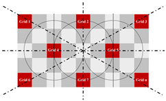
Land 14 01029 i006
Plaque
-type
The spatial organization and functional distribution within the historic district exist in the form of irregular patches, reflecting construction activities, urban development, functional zoning, and environmental constraints of different historical periods.(1) Irregular distribution: functional areas or historical stratification in the district show patchy distribution with obvious boundaries.
(2) Interlocking and overlapping: different functional areas interlock or overlap with each other spatially, forming a complex layered relationship.
(3) Independence and interaction: patches independently form a functional area, but there are interactions and connections between them.
Land 14 01029 i007
Disclaimer/Publisher’s Note: The statements, opinions and data contained in all publications are solely those of the individual author(s) and contributor(s) and not of MDPI and/or the editor(s). MDPI and/or the editor(s) disclaim responsibility for any injury to people or property resulting from any ideas, methods, instructions or products referred to in the content.

