Article

Spatial Compatibility of Landscape Character State Assessment and Development Projects at County Scale: The Case of Songzi City, China

Department of Landscape Architecture, College of Horticulture and Landscape Architecture, Southwest University, Chongqing 400715, China
Land 2025, 14(5), 1019; https://doi.org/10.3390/land14051019
Submission received: 29 March 2025 / Revised: 27 April 2025 / Accepted: 28 April 2025 / Published: 8 May 2025

Abstract

:
Rural landscape character assessment (LCA) is significant for identifying and understanding rural landscapes and maintaining the cultural connotations of the rural vernacular. Taking the rural area of Songzi City as an example, this study identifies the landscape character (LC) and analyzes the coupling between the current state of its LC and a construction project based on the depth of rural landscape planning in the county and combining the ecology, arable land, and water body protection boundary as constraints. Thus, we obtain the “point, line, and surface” site selection suggestions for the construction activities of leisure agriculture, power grid, and energy facilities, and the zoning classification and layout control strategies for LC are subsequently proposed. The results show the following: (1) The county LC factor is a combination of natural and human factors used to obtain 165 LC areas in Songzi City. (2) The current state of rural LC is used to determine LCs from shallow to deep and to provide the basis for index selection and judgment for evaluation. (3) The coupling relationship between rural LC and construction projects varies and must be judged using subjective and objective methods, desktop research combined with field analyses, and multi-stakeholder participation. Based on the perspective of coupling and coordinating human and landscape, this study applies local-scale LCA to practice, strengthens the interface with rural construction planning, and provides research ideas and methodological references for the sustainable control of rural LC.

1. Introduction

The inter-relationships and interactions between human activities and landscape environments in the present and past have produced and influenced the landscape appearance and character. Landscapes have changed rapidly in recent decades with the disappearance of traditional cultures and the emergence of new landscapes. Owing to the risk of landscape homogeneity and low-quality development, landscape character assessment (LCA) has become popular worldwide under the call of the European Landscape Convention (ELC); it has become an important interdisciplinary tool, including two phases of landscape character (LC), identification and evaluation, whose significance and value are to help manage the development and change of LC and to accept and accommodate LC on the premise of fully recognizing it. Using LC to accept and accommodate changes is a scientific approach to landscape management [1,2,3].
From the early stages of its development to the present, LCA research has been mostly based on a typological perspective to explore the selection of landscape factors, different research objects, and differences in methodological techniques and has formed a set of more mature research paradigms [4,5,6,7,8,9,10,11,12,13]. Knowledge of LC focuses on the surface without deeper knowledge of the state of existence of LC, and lacks a more relevant and in-depth examination after the identification of LCA; thus, the identification stage of LCs is often disconnected from the evaluation stage. Although the evaluation stage was developed in parallel with the identification stage, the heat of the last decade has mainly focused on the identification of key LCs, landscape sensitivity, landscape value, quality, and capacity to ensure that changes caused by human activities are in line with the development of LC and enhance them as much as possible [2,4,7,10,11,13,14,15,16,17]. However, the object of evaluation is mostly based on the landscape environmental substrate itself, which makes it difficult to form a map of landscape types to directly guide planning practice. In the UK, much work has been done in this area, and most counties have adopted manual research and recording of character conditions for each LCA after the identification of LC for a certain type of construction project; however, it is based entirely on subjective judgment, in a single way, and there is no further spatial deployment arrangement for construction projects [8,18]. The sustainability of LC involves maintaining its characteristic state of diversity, differences, and continuity. Therefore, an assessment system should be constructed based on the relationship between construction activities and the current state of LC, starting from the coordination of the relationship between human and landscape resources, which will lead to a more practically meaningful stewardship and sustainable development of rural LC.
This study has an important scale of planning coordination and practice for villages, county and city domains. Songzi City in China was consequently selected as a suitable case study. We obtained the identification results of LC with object specificity by combining natural and cultural factors and introduced 22 landscape status indicators to deepen our understanding of character areas. Considering LC as an important resource, the content of the judgment evaluation stage was integrated by coordinating construction projects with the current survival of LC. The coupling coordination degree of LC was obtained for three projects. Protection boundary for ecology, arable land, and water bodies were conditions for constraints. Recreation points, corridors, contiguity, and aggregations were introduced separately after considering the characteristics of the different projects. Finally, the layout system of local-level recreational agriculture points, power facility lines, and energy facility surfaces was formed, and a proposed optimization strategy of landscape composition structure was developed to guide the future landscape management planning of rural areas, and the content and methodological framework of this study is shown in Figure 1.

2. Materials and Methods

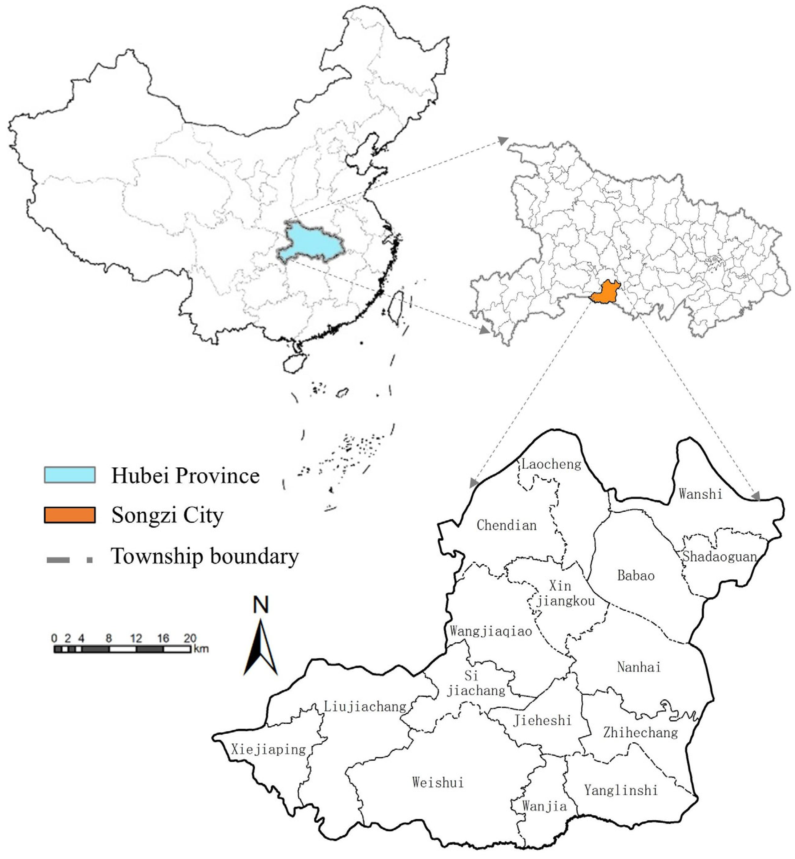
2.1. Research Subjects

Songzi, a county-level city with a comprehensive scale of counties (cities and districts), is located in the southwest of Hubei Province, China, 111°14′–112°02′ E, 29°53′–30°22′ N, spanning 77 km from east to west and 55 km from north to south. It is situated along the southern bank of the Jing River, in the middle reaches of Yangtze River. It has a land area of 2235 square kilometers, with 14 towns and 2 townships under its jurisdiction and, as of 2020, a population of 650,000. Songzi faces the dual needs of development and protection of rural landscapes under the construction of the Yangtze River Economic Belt.
Songzi is located in the transition zone between the Jianghan Plain and the mountains in West Hubei, and the whole area shows a stepped pattern of “three parts plain, three parts hills, and four parts mountains”. The mainstream of the Yangtze River runs through the entire country, and the river network is intertwined, which constitutes a compound water conservancy landscape system with various types of rural LCs and risks under various geohydrological environments. Songzi City has a long humanistic history, and its cultural landscape is hierarchical in nature, including prehistoric culture, Chu culture remnants, and immigrant culture. Within the territory, there are traditional agricultural areas, modern agricultural belts, and industrial and mining legacies, with obvious conflicts between the traditional and modern landscapes. In addition, Songzi City has a comprehensive scale, adaptable to medium-scale county (city) area planning. This background environment provides a more comprehensive sample for studying rural LC (Figure 2).

2.2. Data Sources and Methodological Content

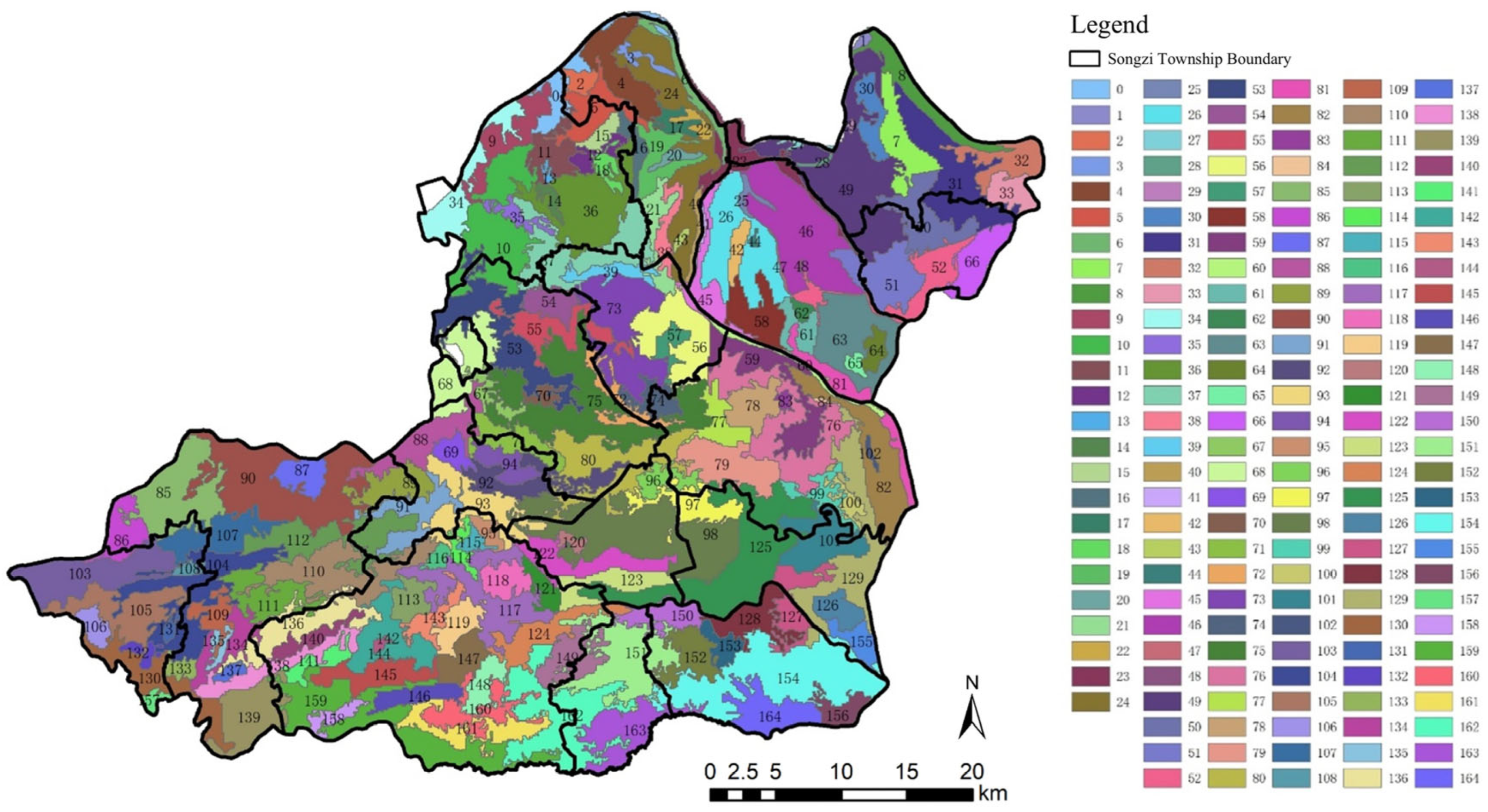
2.2.1. Identification of Landscape Characters

The local-scale landscape characteristics study was set at 1:50,000, with a resolution of 30 m. A preliminary survey of the landscape of Songzi City was conducted based on the hydrology and important rural habitats, and a factor set of landscape characteristics was established. The factors were selected using IBM SPSS Statistics 27 correlation analysis and categorical regression. The village distribution factor had the highest weight, followed by land use, topography, geomorphology, arable landform, soil, and place name. Among them, the land-use types come from the 2023 version of the Resource and Environmental Science Data Platform, the topography and geomorphology data come from the NASA DEM 30 m resolution 2020 version of the analysis in ArcGIS, the soil type comes from the 2023 version of the Nanjing Branch of Chinese Academy of Sciences at 30 m resolution, and the toponymic type comes from the extraction of the village names from Google Maps v3 with semantic analysis and manual classification; the village distribution factor and the arable landform factor are based on the manual interpretation of high-definition images. The natural character component factors, i.e., land use, topography, and soil, were fuzzy and had to be superimposed using ArcGIS to obtain fixed boundary LC patches. The cultural character component factors were extracted from the patches for further division, combining the area, perimeter, and fractal dimension of the patches as the configuration factor, and the x and y coordinates of the center of the patch mass were used as the null position factors. We improved the original data package of the K-prototype in Python 3.8.5, including the weighting process and the writing of the elbow method code (see Appendix A for the code), and then weighted clustering and automatically determined the optimal number of clusters to obtain the landscape character types based on the IBM SPSS Statistics 27 results of the above three compositions. On this basis, by introducing eCognition, which is an object-oriented image classification software, the three parameters “scale parameter”, “shape”, and “compactness” were used to delineate and recognize landscape character type boundaries, thereby obtaining 165 LCAs with uniqueness [9,13]. All the above processes further increase the reliability of the recognition results and provide accurate units of analysis for subsequent evaluation studies (Figure 3).

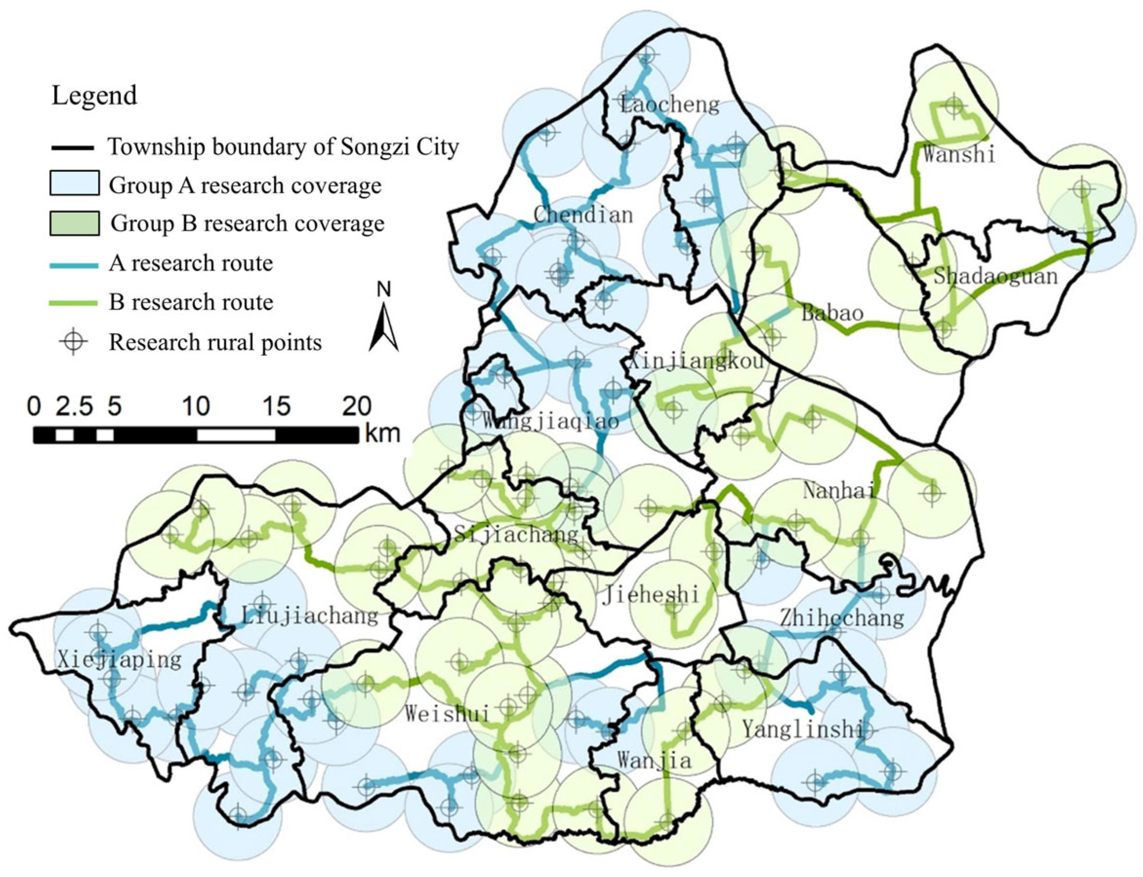
2.2.2. State Cognition of Landscape Characters

(1)
Landscape character state indicators
State cognition deepens LC identification and is the basis of LC evaluation. The composition of indicators is (a) statistically based, (b) pattern containing, and (c) assessment seeking [19]. This divides the LC status into three aspects: composition, pattern, and attribute statuses, starting from compositional statuses and progressing to pattern statuses and attribute statuses, which are the richest in terms of the number of indicators, and the state indicators achieve the gradual process of transforming from complete objectivation to subjectivation. This study considers the aspects that may be influenced by the specific types of construction projects in Songzi on LC status as clues, and employs a combination of objective, subjective, tangible, and intangible factors to establish the LC status indicator dataset; 22 numbered indicators (Table A1) were obtained, constituting a cognitive system of the LC status in Songzi.
The compositional state is a further excavation of the LCA’s factor composition of its own state based on the sensory factors in the recognition stage, which can have a high or low value, but is not subject to the intervention of human subjective concepts. The composition state in this study included four indicators: color contrast, spatial hierarchy, settlement boundary sense, and regularity. Further investigation of the composition state of the LCA factors was performed subjectively based on the sensory factors in the identification stage. The strong color contrast indicated the visual attractiveness of the landscape and the sense of change very well; for projects with a high demand for beautiful scenery, this indicator could provide a reference. Spatial hierarchy represents horizontal and vertical spaces and an increase in the three-dimensional perception of the landscape; the higher its value, the richer the spatial composition of the landscape. The sense of settlement boundaries is represented by its degree of assertiveness: the stronger the boundary sense, the higher the acceptance of artificial facilities. The degree of regularity refers to the sense of order and regularity of landscape elements in LCA; the higher the degree, the higher the acceptance of artificial facilities.
The pattern state mainly analyzes the spatial distribution of LC, including the spatial arrangement and combination of LC patches of varying sizes, complex shapes, and types and their relationships with each other. In this study, two core indicators of diversity and continuity, which have a research basis, were selected, and both were estimated using subjective and objective means. The objective approach used the LC patches of Songzi City as a base map to calculate the diversity (ed, shdi, lsi, pd, pr) and continuity (cohesion, ai, division, split, lpi) pattern indices, and the moving window radius was set to 540 m. A semi-variance function was introduced to obtain the landscape pattern of Songzi City at 540 m using inflection points for the appropriate moving window radius. The new variable “FAC1_2” representing diversity was 89.623%, and “FAC1_1” representing continuity was 88.396%, as calculated by factor analysis through SPSS to obtain the objective data of Songzi City’s diversity and continuity of landscape characteristics. Subjective data judged by manual field research on LCA in Songzi City showed that diversity was determined by the variety and richness of the types and combinations of internal landscape elements in LCA. Continuity was judged by the color, texture, temporal continuity, and continuity of the internal landscape elements.
The attribute states were subjectively oriented, enhanced, and composed of all state indicators of LC, except for the compositional and pattern states. This study combines the characteristics of the research object and the operability of the experiment to include accessibility, visibility, intervisibility, disturbance, wilderness, recreation, tranquility, security, human–scene interaction, human–scene relevance, emotional state, live attitude, sense of place, rarity, attractiveness, and culture. Among these, the accessibility and visibility indicators are combined with subjective and objective judgments. For the accessibility objective data calculation, the source point was the center of the LCA of Songzi City, and the main roads were selected and set up for resistance distribution to derive the road resistance surface and obtain accessibility landscape characteristics. Subsequently, the subjectivity of accessibility was judged using a combination of manual multimodal rapid access to the area, population density, and human mobility. Visibility objective data were calculated by combining 30 m-resolution digital elevation model data with height overlay based on land-use assignment, and the source of view was divided into a settlement with static characteristics and a road system with dynamic characteristics; the subjectivity of visibility was calculated by manually analyzing the open, near-open, semi-open, near-closed, closed, skyline level, and accessibility of the LCA. The objectivity of disturbance was judged by the objective data map of disturbance obtained from the nuclear density of settlements, and its subjectivity was judged by the scale and strength of the integration of man-made facilities in the LCA. Tranquility was associated with “quality and state”, which was synonymous with “calm”, “quiet”, and “peaceful”, and was objectively recorded by finding the position of the human and natural sound balance of each LCA using the “Decibel Noise Test 1.5.8” app for noise recording. The subjective recordings were judged by the visual perception of the site and the density of traffic facilities.
Other attribute status indicators were obtained through subjective judgments from field research on LCAs in Songzi City. Intervisibility refers to the relationship between the LCA and the surrounding area, including the strength of association, visibility, and accessibility. Wilderness, which refers to an area formed and influenced mainly by nature, is widely considered a pristine rural area with natural flora and fauna that are relatively undisturbed by human activities. This was judged based on the population, density of facilities, plant forms, and frequency of wildlife visibility. Recreation was determined by the number and distribution of facilities in the area, traffic, and landscape recreational ability. The sense of safety was recorded according to the intuitive feeling of the researcher on-site, and the judgment was based on the degree of management, ease of transportation, flow of people, and presence of dangerous facilities. The human–landscape interaction type was based on visual perception and classified as landscape dominant, human and landscape co-dominant, or human dominant; it was judged by the extent of the role of human factors. Human–landscape correlation refers to the degree of correlation and integration between LC and rural areas. The emotional state indicated the subjective feeling of being in the LCA from the viewpoint of tourists and residents and was divided into five types: happy, happier, no feeling, low, and unhappy. The live attitude was judged by the degree of the maintenance of LC and whether the rural area was vibrant, more vibrant, normal, near idle, or idle. The sense of place was gauged by how recognizable the landscape elements of the LCA were and their typical local characteristics. Rarity was judged based on the rarity and uniqueness of the LC and their combinations. Attractiveness indicated that the LCA or its landscape elements had a deep and mysterious mood and the effect of moving to a different scene, and thus, people wanted to continue exploring the feeling. Culture was measured by the number of human factors in the LCA, the presence of representative cultural features, and the creation of an artificial cultural atmosphere.
(2)
State cognitive practice approach
There are 165 types of LCA in Songzi City. Through our preliminary trekking and by measuring the unmanned aerial vehicle field of view, this study adopted a sampling method, obtaining 88 sample points that were unevenly distributed to fit the size of the character area to cover the full LCA significantly. Each sample point was in close proximity to the village, and the sample points were distributed as shown in Figure 4.
The research team consisted of ten members, all of whom were teachers and PhD and master’s students who specialized in landscapes and had a specific theoretical and practical foundation in LC. Before conducting the field research, the members were familiarized with and involved in the desk phase of landscape characterization and had a basic understanding of the background environmental information of Songzi. To improve the efficiency of the investigations, routes A and B were designed, and the members were divided into two groups to conduct the survey simultaneously over two periods.
Several techniques were employed to record the status indicators of the LCA at the sample points. Drones (The DJI Air Series drones are manufactured by SZ DJI Technology Co., Ltd. in Shenzhen, China.) were employed to film, depending on the terrain and landscape, with circular shots and 360-degree cameras (Sony Cyber-shot RX100, Sony, Tokio, Japan) covering a radius of 3–5 km, and the top planes of the center points of the LCA and the aerial view and top planes of the rural landscape were filmed. Rangefinders 7.9.7 and global positioning systems were used for positioning and local dimensional measurements. The decibel noise test was conducted by selecting the semi-natural state of each sample point in the landscape area for approximately 5 minutes of static sound recording, sound fluctuation data analysis, and average decibel calculation. The walking path was recorded through a two-step outdoor application, and we took photos and recorded videos of nodes, including the skyline, 360-degree panoramic views, local architecture, local landscape, elements of rural landscape features, architectural style embodiment, and public space construction. A survey was carried out by distributing interview questionnaires to villagers at the sample sites.
(3)
State cognitive awareness questionnaire
It is important to involve the local people in the assessment of LC and the subsequent design, planning, and management [20]. Residents are the most basic composition of a local population, and questionnaires completed by residents are the best source of subjective indicators regarding perceptions of LC status to supplement sensory perceptions based on the subjective judgments of the research team and compensate for the inability of researchers to obtain overall perceptions in a short time. We focused on four dimensions that might contribute to landscape stewardship: perception of the current state of the landscape, human attachment to a place, human behavior in the landscape, and the tendency to maintain the landscape. Thus, a total of nine indicators were used. Additionally, textual descriptions of the time of residence and popular and unpopular landscape elements were included. The questionnaire was designed as shown in Table A2, and the results were based on direct interviews with residents. The researcher composed the indicators in an easy-to-understand manner and conveyed them to residents in their vernacular, capturing their true feelings in the form of chats and recording the indicators through analysis from an expert perspective.

2.2.3. Character Evaluation Based on Specific Construction Projects

(1)
Selection of specific construction projects
Most construction projects’ development type can be summarized into three forms, namely, point, line, and surface, which are scale-based. At the county-scale planning level, the point cannot focus on the specific residence or building but has the group boundary of the settlement, such as village; the line cannot focus on the specific location of the coordinate level and can only be the planning level of the layout; and the surface is also more for the scale of the large regional division. Thus, the specific construction projects in Songzi were finally selected: point source impact type (leisure agriculture), line source impact type (high-voltage power infrastructure), and surface source impact type (wind farm energy facilities), as cases to form the structure of the point, line, and surface composition of the construction projects. On the one hand, these three construction projects are more representative and typical of the points, lines, and surfaces, and many areas will have the construction of these three projects to consider; on the other hand, these three construction projects in Songzi City are the current problems and stress the urgency of the demand.
(2)
The method of expert participation and questionnaire design
The purpose of expert participation was to measure the direction and degree of impact on the LC status indicators according to the specific type of construction project and to determine the screening, weighting, and positive and negative directions of the status indicators in the coupled coordinated assessment system. Participation in the assessment process requires consideration of (a) the scope of the participants, (b) the stages of participation, and (c) how to participate [20]. Therefore, stringent requirements are required for the selection and participation depth of expert composition. The expert sources were divided into three categories: decision makers (central, regional, and local governments), influencers (public institutions, relevant professional experts, and enterprises), and participants (farmers, residents, tourists, and community groups). The specific requirements included a background in the landscape industry, the ability to provide a comprehensive evaluation perspective based on different occupations within the industry, and the ability to have some knowledge of the research objects and the connotations of LC. Further, the experts were asked to describe and communicate the concept of landscape characteristics and answer questions through direct communication in person or through telephone interviews; thus, the experts achieved accurate and scientific ratings based on a full understanding.
In view of the above considerations, 13 questionnaires were received. The expert team comprised three teachers, four students (two PhDs and two master’s degrees), two entrepreneurs, two public officials, and two institutional personnel. The questionnaire for the judgmental evaluation (Table A3) was designed to address three areas: (a) whether or not the construction project had any mutual influence on the indicators of the current state of LC to determine the choice of indicators, (b) the degree of influence was compared to determine the weights of different status indicators in each construction project system, and (c) the positive and negative directions of influence, i.e., whether the interaction between state indicators and construction activities was positive or negative.
(3)
Calculation of the coupling degree of specific construction projects
The field scores for 22 status indicators were recorded for 165 LCAs during the field research phase. Thereafter, according to the experts, to determine the presence or absence of impact and the degree (indicator weights) and direction (positive or negative indicators) of the impact on the status quo of LC with local-level specific project impact and LC strain, the project coupling coordination degree of each project in the 165 LCAs was obtained. The calculation process is as follows (the serial numbers are listed in Table A1):
Leisure agriculture project coupling coordination degree = a1 × 0.0462 + a2 × 0.0355 + a3 × 0.0161 + a4 × 0.0435 + b1 × 0.0449 + b2 × 0.0435 + c1 × 0.0502 + c2 × 0.0429 + c3 × 0.0449 − c4 × 0.0442 − c5 × 0.0489 + c6 × 0.0569 + c7 × 0.0476 + c8 × 0.0516 + c9 × 0.0596 + c9_1 × 0.0476 + c10 × 0.0482 + c11 × 0.0455 + c12 × 0.0489 + c13 × 0.0388 + c14 × 0.0442 + c15 × 0.0502.
Degree of coupling coordination of power grid facilities projects = − a2 × 0.0521 + a4 × 0.0456 − b1 × 0.0521 − b2 × 0.0684 − c1 × 0.0749 − 2 × 0.0782 − c3 × 0.0662 − c4 × 0.0738 − c5 × 0.0695 + c6 × 0.051 − c7 × 0.0402 − c8 × 0.076 + c9 × 0.0543 − c9_1 × 0.0467 − c11 × 0.0326 − c12 × 0.0402 − c14 × 0.0402 − c15 × 0.038.
Energy construction project coupling coordination degree = a2 × 0.0294 + a3 × 0.0456 + a4 × 0.0578 − b1 × 0.0477 − b2 × 0.068 − c1 × 0.0548 − c2 × 0.07 − c3 × 0.0649 − c4 × 0.0761 − c5 × 0.068 + c6 × 0.0507 − c7 × 0.0598 − c8 × 0.0385 + c9 × 0.0548 + c9_1 × 0.0416 − c11 × 0.0335 − c12 × 0.0355 + c13 × 0.0477 − c14 × 0.0304 + c15 × 0.0254.
The calculation results were imported into ArcGIS, and the distribution of the human–landscape coupling coordination degree of leisure agriculture, power grid facilities, and energy construction was obtained, as shown in Figure 5.
(4)
Deployment evaluation model for specific construction projects
In addition to the landscape-based research perspective, the status quo needs to comply with the existing planning elements in the territory, such as the protection boundary of ecology, arable land, and water bodies, as a binding indicator term for stewardship. By combining the different forms of planning layouts represented and oriented by the three projects, an evaluation model for the deployment of specific projects was established, as depicted in Figure 1.
Model Composition I is the coordination degree of the coupling between the current state of LC and the construction project.
Model Composition II uses the protection boundary of ecological and arable land and water bodies for the range correction of the point–line–surface arrangement of specific construction projects. The ecological and arable land protection boundary information was obtained from Songzi City’s Natural Resources and Planning Bureau. The information on the protection boundary of water bodies was extracted through land use and based on the provisions of the “Hubei Province River Management Implementation Measures”, “Hubei Province Lake Protection Regulations”, and “Hubei Province Reservoir Management Measures”. The average outward extension of the water area by 20 m was taken as the range of the r protection boundary, and the area shared by the three areas in the LCAs of Songzi was calculated. The results are presented in Figure 6.
Model Composition III is the sub-evaluation of leisure agriculture grading points, contiguity of grid facilities, and aggregation of energy construction. Recreational agriculture-graded points were evaluated as follows: (a) Recreational agriculture selected points were obtained. We observed the leisure agriculture coupling coordination degree of the LCAs, where 234 village points were located in Songzi City, combined with protection boundary constraints, and divided them into four grades using the natural interruption point-grading method. (b) According to the cultural preservation unit points of Songzi City, combined with the point of tourist attractions extracted using Bigemap, we obtained “leisure tourist attractions” and superimposed the village points as the source points of the leisure tourism and cultural corridor. Considering that the resistance of tourists to the source point mainly originated from the influence of traffic restrictions, topography, and land use, an integrated resistance surface was formed based on the above three aspects. Finally, a cost–distance analysis was carried out using ArcGIS to obtain leisure tourism and cultural corridors.
The connectivity of the grid facility was evaluated. According to the current situation of Songzi City exploration, overall, the integration of high-voltage facilities, grid corridors, and landscapes in Songzi is poor. Some high-voltage facilities have been established in areas with good scenic resources and sightlines. Furthermore, the integrity and continuity of the landscape were not considered, and the corridors of the facilities were set at will, destroying the effects of the landscape stretches. To solve the current problems, we first measured the coupling of different landscape areas to the grid facilities project, i.e., the coupling coordination basement, and analyzed the contiguity. Based on the continuity map obtained from the cognitive stage of the Songzi state, we extracted areas with high continuity in ArcGIS using the aggregation surface tool. The aggregation distance was set to 30 m (city and county scale). Patches with an area of less than 500,000 square meters were excluded, and a contiguous distribution of high and low values of continuity was obtained.
An aggregated evaluation of the energy facilities was conducted. From the perspective of the mutual influence between LCs and energy construction, coupling and coordination were used as the base layer of the landscape resources with the capacity for the construction of wind farms and other energy facilities. Energy facilities must be distributed in patches of agglomerations; therefore, coupling coordinates in zones where high values are clustered are more suitable for energy facilities, and the opposite is true for low values. Furthermore, we provide landscape-level suggestions and references for future locations and layouts in addition to an aggregation analysis for the centralized layout of energy facilities. The raster map of the human–landscape coupling coordination degree distribution of the energy facility projects was introduced into the hot spot analysis (Getis-Ord Gi*, which is suitable for a detailed analysis of the location of hot or cold spots and their spatial distribution patterns, helping to identify aggregation features within a specific area) using the ArcGIS spatial statistics tool [21]. This was used to calculate the high and low value aggregation distributions of the coupling coordination degree of the LCA in space.

3. Results

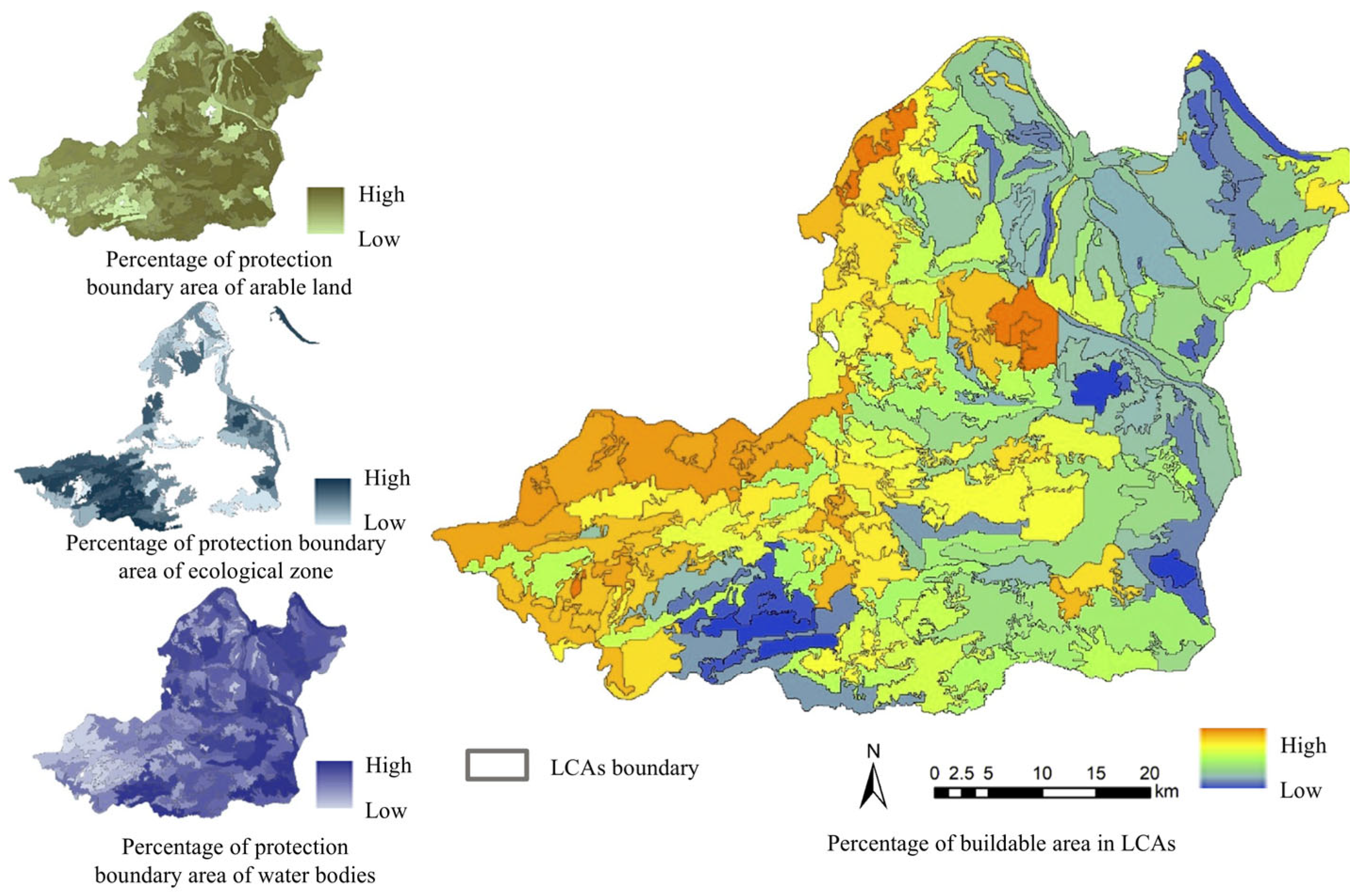
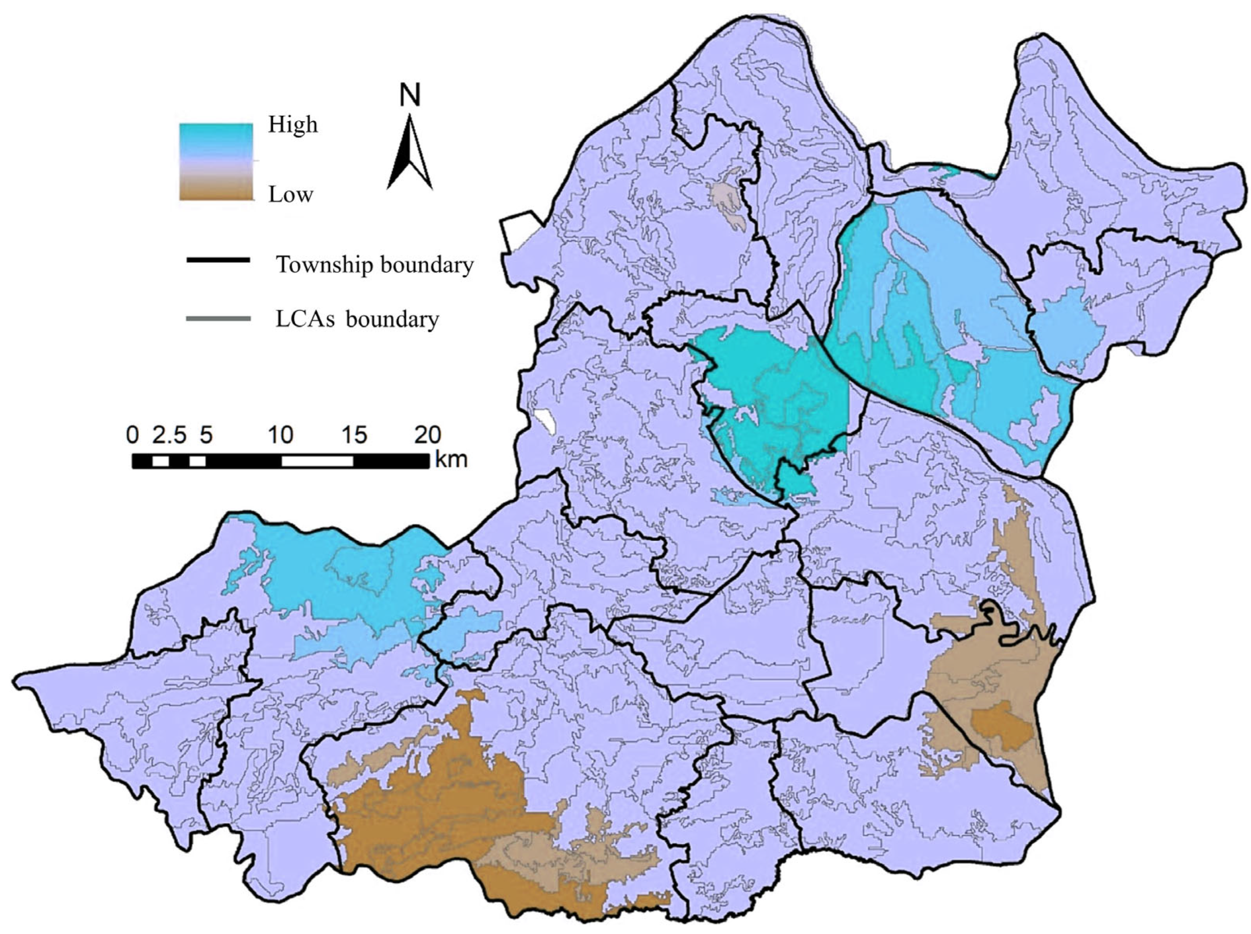
3.1. LCA Distribution and Status

The LC distribution of townships is presented in this section. There are 16 towns and villages in Songzi City, and the LCs of Wangjiaqiao Town, Liujiachang Town, Yanglin Town, and Jiaoshui Town in the hilly and mountainous areas are rich in variety. Further, the LCs of Yanglin and Wangjiaqiao not only were rich in patches, but also had complex boundaries, whereas the LCs of Jiaoshui and Liujiachang were more varied but relatively evenly distributed. The LCs of Babao and Shadaoguan Town in the plain area had relatively few types of LCs, several homogeneous boundary shapes, and large LCAs.
The data of 22 indicators of the three aspects of LC state cognition in Songzi were normalized using SPSSAU, and 13 of them comprised subjective and objective structures, as depicted in Table A1. An equal weight overlay was used to import the processed data results of the 22 indicators into ArcGIS, and the graph group with LCAs was obtained as the analysis unit (Figure 7). As displayed in the figure, there are differences in the distribution of each indicator. Further, there were similar distribution trends for sensory aspects such as security, emotional state, culture, and recreation, and similar distribution trends were observed for visibility, mutual visibility, live attitude, continuity, sense of settlement boundary, and regularity.

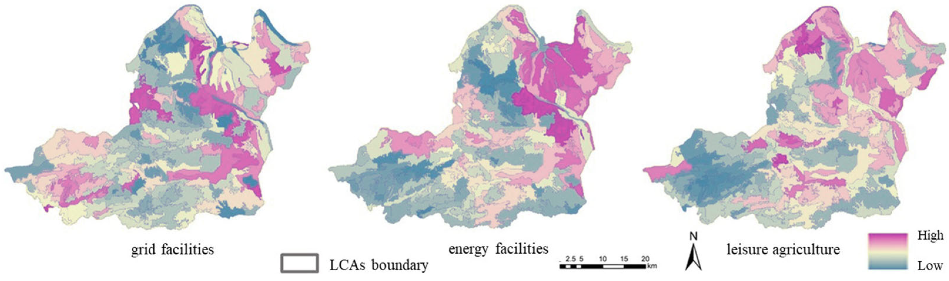
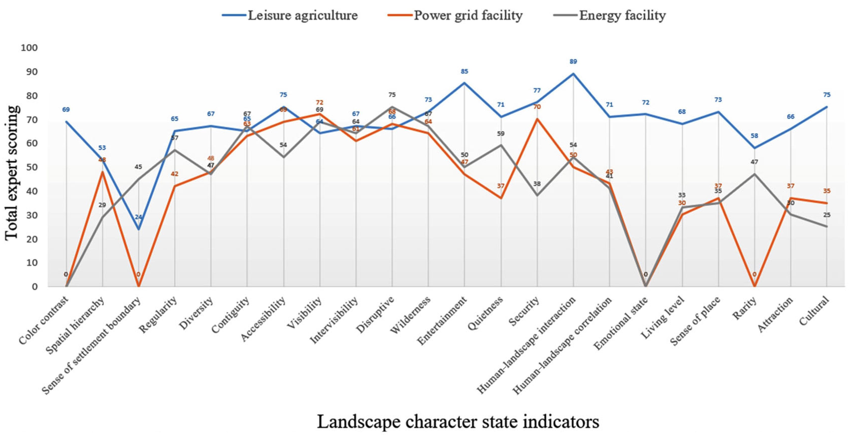
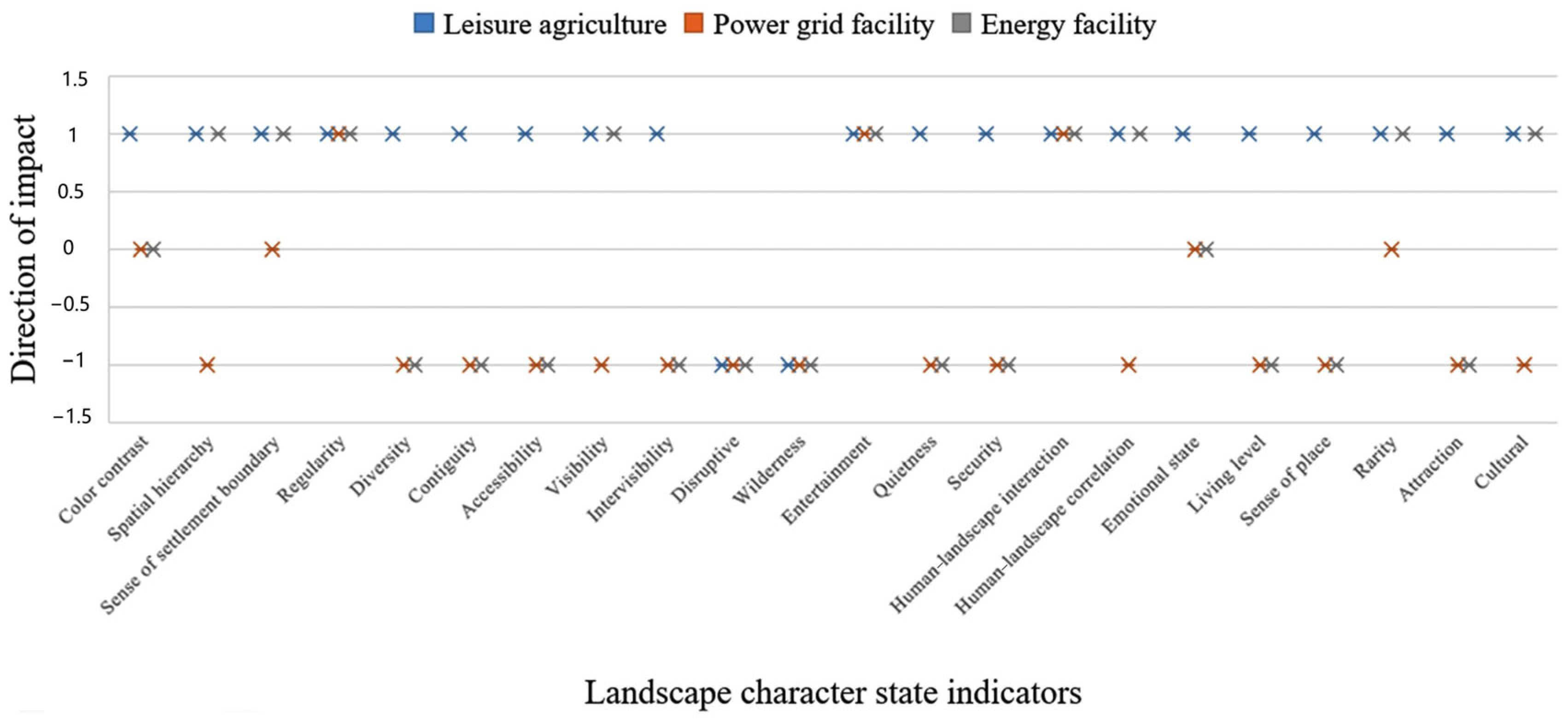
3.2. Analysis of Expert Evaluation Results

The results of the expert evaluation are shown in Figure 8, which shows the degree of impact, and Figure 9, reveals the positive and negative directions of the impact.

3.2.1. Results of the Evaluation of Leisure Agriculture Judgment

The experts agreed that the 22 indicators of the selected LC states were relevant to the construction of leisure agriculture. In terms of the degree of influence, the highest score was given to the type of human–landscape interaction, indicating that LCAs with high human factor influence were conducive to the construction of recreational agriculture. Furthermore, it indicated that recreational agriculture could further enrich the human nature of the characteristic areas, followed by recreation, which reflects the richness of landscape elements and the significant advantage of recreation for recreational agriculture. Furthermore, the sense of security recorded a high score, reflecting the human need for other state indicators such as accessibility, culture, and tranquility, which also had high scores. Relatively low scores on settlement boundary and spatial hierarchy did not significantly influence leisure agriculture. In terms of positive and negative influences, almost all LC state indicators and leisure agriculture positively influenced each other, except for disturbance and sense of wilderness, which were negatively influenced. The experts believe that the lower the degree of integration of man-made facilities in the character area, the greater the disturbance, which is not conducive to the construction of leisure agriculture. Similarly, the introduction of numerous man-made facilities for leisure agriculture will reduce the sense of wilderness for LCs. The areas with a strong sense of wilderness do not have supporting facilities to establish leisure agriculture; therefore, they are negatively influenced.

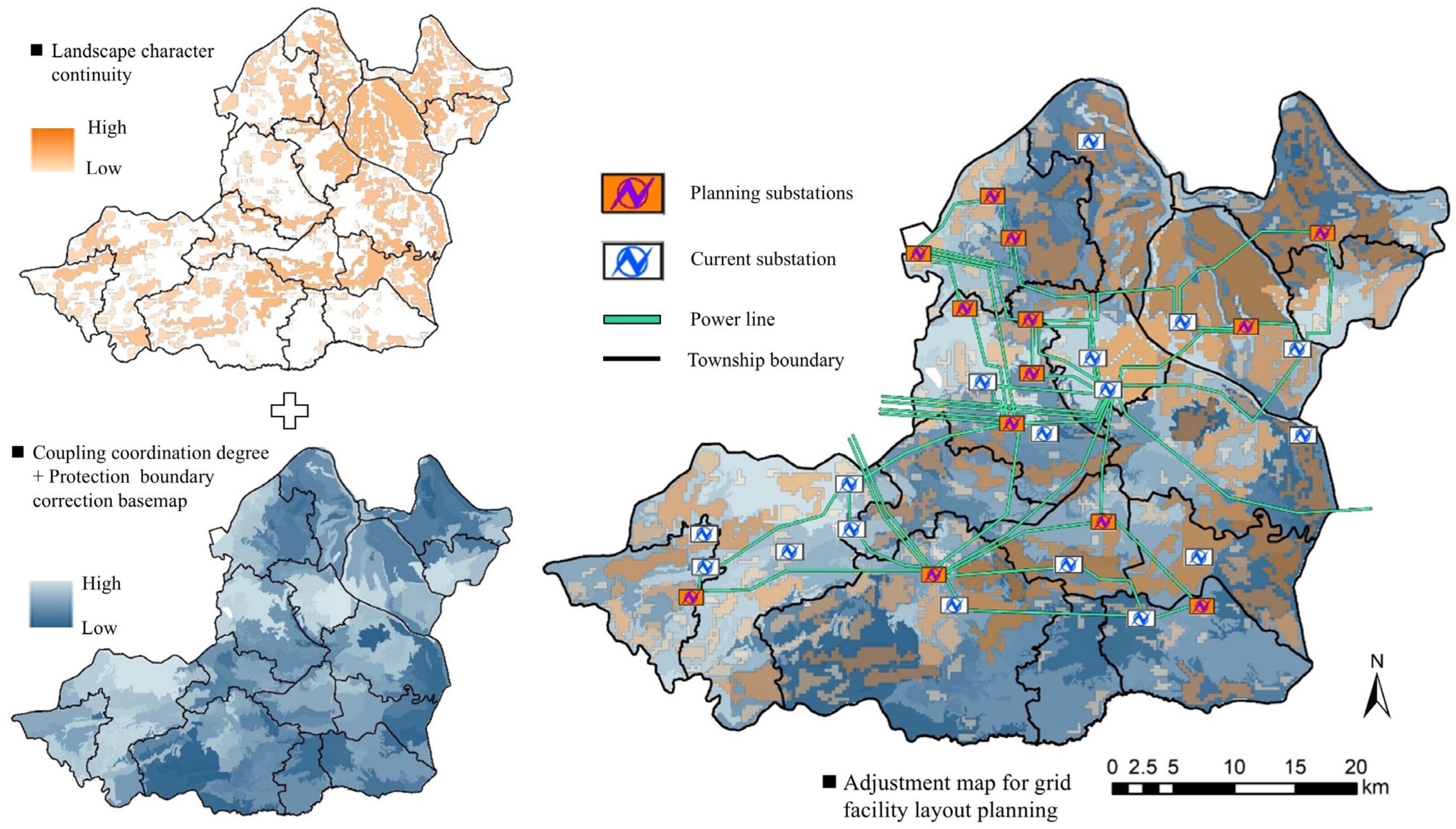
3.2.2. The Results of the Evaluation of Grid Facility Judgment

In terms of the presence or absence of influence, the color contrast of the composition state and indicators of cluster boundary sense, as well as the emotional state and rarity indicators of the attribute state, did not have a mutually influential relationship with grid facilities. From the analysis of the degree of influence, visibility was the most important indicator for the experts; they believed that grid facilities had a significant impact on the spatial vision of the LCA. This was followed by a sense of security because the grid had a relatively high voltage, the line was charged, and people had to maintain a safe distance from it, which resulted in a sense of uneasiness. Additionally, accessibility and interference had significant impacts; state indicators, such as live attitude, sense of place, and attractiveness, had a mutual-influence relationship, but the effect was relatively small. In terms of positive and negative influences, the construction of power grid facilities negatively influenced most of the LCA indicators, such as the continuity, diversity, and accessibility of LC. However, it positively influenced regularity, recreation, and human–landscape interaction, mainly because power grid facilities are artificial structures; thus, they strongly influence regularity and human factors. Additionally, the recreational facilities accompanied the power supply of the power facilities, and they therefore correlated positively with recreational nature.

3.2.3. Energy Facility Judgment Evaluation Results

This analysis is primarily based on wind turbines and farms. In terms of the presence or absence of influence, most experts believed that color contrast and emotional state did not mutually influence the construction of energy facilities. In terms of the degree of influence, the top 3 state indicators were disturbance, visibility, and continuity. Other state indicators with a strong influence were wilderness, intervisibility, and tranquility, and indicators with less influence were attractiveness and culture. The analysis of the positive and negative directions of impact showed that the number of positive and negative indicators was half, and the positive representative indicators were visibility, regularity, and human–scene interaction. Wind turbines are man-made fixed-structure facilities; thus, an LCA with strong regularity and human interaction can considerably absorb the impact of wind facilities on the landscape. The greater the prominence of landmarks in open areas, the higher the visibility and the stronger the construction capacity of wind facilities. Negative indicators were continuity, wilderness, and accessibility. The wind facility had a specific height, which blocked the view of the LCA in vertical space, thereby disrupting the spatial continuity of LC. Furthermore, both man-made and wind facilities generated noise during operation, which reduced the wilderness of the LCA; thus, there was a negative relationship. Additionally, wind facilities are generally installed in areas that are not easily accessible to avoid human damage; thus, the more accessible the LCA, the less favorable the construction of wind facilities.

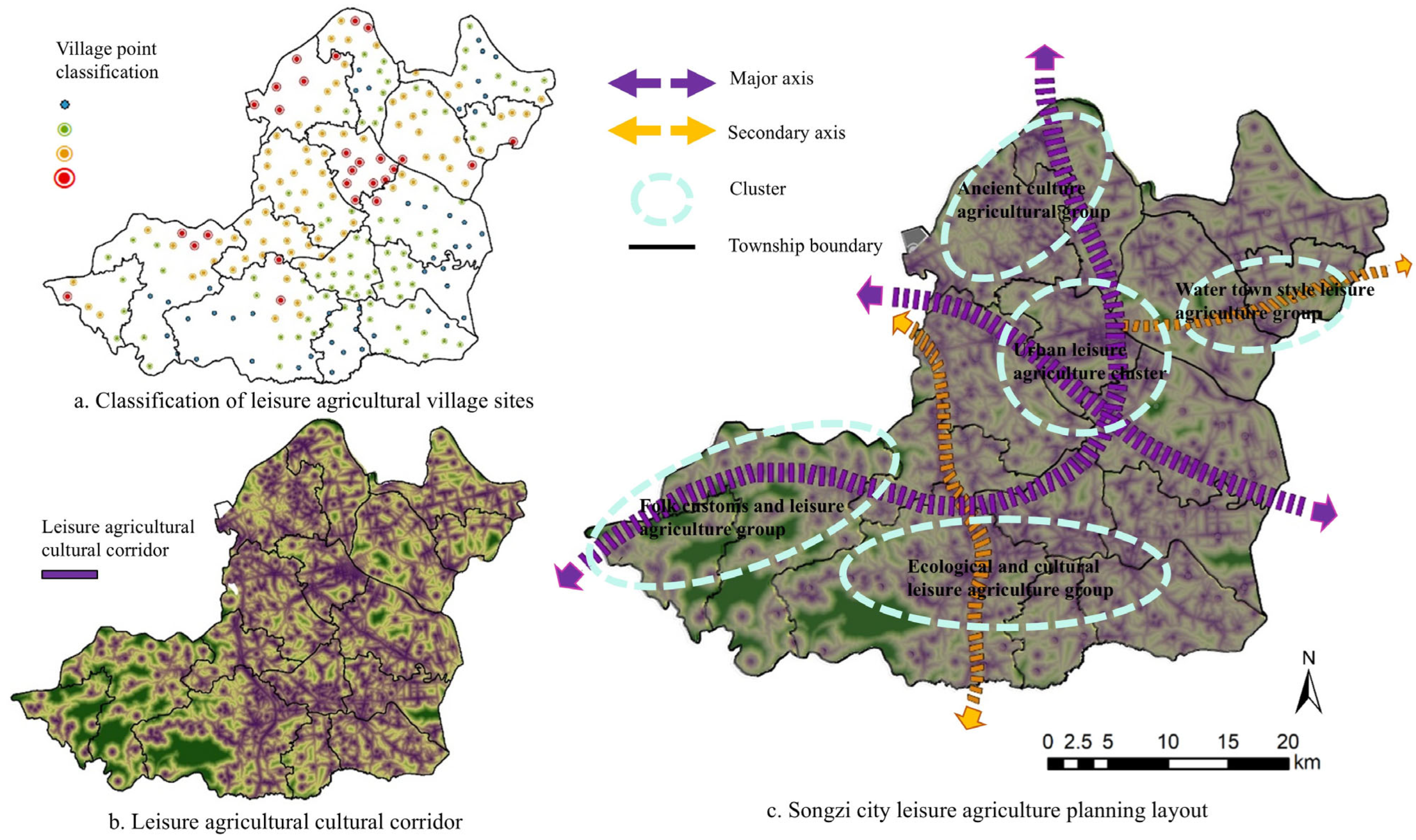
3.3. Planning Layout of Specific Construction Projects

3.3.1. Leisure Agriculture Layout

The coupling degree between the current situation of rural LC and leisure agriculture was analyzed. The red color indicates the village with the highest potential for leisure agriculture construction, followed by orange, green, and blue, indicating the village with the lowest potential, generally including villages lacking rural landscape resources, leisure and recreational facilities, and mainly ecological protection (Figure 10a). The cultural preservation unit points, tourist attractions, and village points in Songzi were combined into the source points of the leisure tourism and cultural corridor and obtained by ArcGIS cost distance analysis based on topography, land use, and traffic accessibility, as shown in Figure 10b. The overall planning and layout of leisure agriculture were obtained from a landscape perspective based on the selected leisure agriculture sites and cultural corridors (Figure 10c).
The planning layout comprises two major axes, two secondary axes, and five core groups for the overall structure of leisure agriculture in Songzi. The two main axes were the Jiangnan Expressway and the tourism development in the river basin, and the two secondary axes were along the Jing-Song Highway and the Jiao-Liu Railway. The five groups are the Ancient Culture Agricultural Group, Water Town Leisure Agricultural Group, Urban Tourism Leisure Agricultural Group, Ecological Culture Leisure Agricultural Group, and Folk Customs Leisure Agricultural Group.

3.3.2. Grid Facility Layout

As shown in Figure 11, the continuity of the LCs in the red area is high, and the line layout of the grid facilities is designed by combining a coupled coordination base, protection boundary constraints, and contiguity analysis. The design principle was based on choosing areas without contiguity, the layout of the grid facilities was significantly oriented in the same direction as the contiguity, and the importance level of the lines was determined according to the degree of continuity of the surrounding LCs.
The results showed that the acceptance of grid facilities was high in Xinjiangkou Town, Liujiachang Town, northwestern Chendian Town, and southern Shadaoguan Town, whereas the acceptance was low in Qiaoshui Town and around Xiaonanhai in Nanhai Town. The areas with high contiguity of LCs were mainly located in the plain, basic farmland region, which had an overall landscape effect of farming despite the variety of crops. Furthermore, the grid corridor needed to be arranged in conjunction with roads and town construction areas; the hilly areas had good LC contiguity in the east and low contiguity in the middle. In hilly areas, the grid facilities must be arranged according to large contiguous trends. The mountainous areas were contiguous and scattered and were also considered for the grid facility arrangement. Furthermore, the topography of the trend in low contiguous and visually inconspicuous locations needs to be considered; the facilities should be located as far as possible, not across the hill.

3.3.3. Energy Facility Layout

Suitable sites for the construction of energy facilities were located in Xinjiangkou, as well as in the west of Babao Township and north of Liujiachang Township, and these areas presented high value aggregation, combined with the wind farm construction plans of Liujiachang and Liulinchong. This indicates that the results of this study are consistent. These towns have more construction projects for urban development and mature infrastructure. For example, Liujiachang is mainly developed using mineral resources and is located in a topographic landscape where the wind direction provides better conditions for wind farm construction. Thus, it could be further selected for construction in spillways and ravines, as well as ridges and peaks that are exposed to high wind areas. In the south-central part of Weishui Township and the eastern part of Zhihechang Township, the surrounding areas centered on the reservoir and scenic areas showed low value aggregation; thus, wind farms should be constructed with caution. The other areas did not exhibit any significant clustering of high or low values (Figure 12).

4. Discussion

4.1. Integrated Structures and Cultural Factors for Landscape Character Identification

Landscape typology should consider the configuration of landscape patches, which Otherwise, I think it’s okay.is the spatial morphology characterizing landscape patches and patches forming mosaics and patterns [22,23,24]. In addition to the two factors of LC component and configuration, the coordinate position is also a key factor in aggregation, especially for large-scale landscape character maps, which have a strong geospatial autocorrelation effect, and neighboring landscape character patches are more attractive and relevant to each other [13]. Compared with the traditional single-component aspect of landscape character factors including natural, cultural, and perceptual [3], this study synthesizes the three aspects of components, configurations, and coordinates to provide accurate identification results for subsequent evaluation.
In terms of cultural factors, the county scale is already somewhat operational, and scoping needs to be combined with land-use units with fixed boundaries through type regionalization rather than rasterization. The predominant form of representation of a village at the county scale is its spatial distribution type, which emphasizes the distribution relationship between the village settlement and the surrounding environment rather than specific buildings [25]. Furthermore, the recognizable character of the farming landscape is the type of spatial distribution of the farmland formed at the local scale. Farming landscape forms and village distribution are typically closely related, constituting a unique local and regional pattern of the landscape [20]. These cultural character factors are expressed outward, whereas culture is intrinsically related. Schaich states that landscape is composed of both natural and human dimensions, and the human dimension includes the emotional, intellectual, and social aspects of people, making it more diverse and unique [26]. Place name type is a better cultural factor for this scale and is more representative of the emotional and intellectual potential relevance, aggregation, and transmission of this culture [2].

4.2. The Practical Value of State Cognition

The introduction of the state cognition stage considerably solves the isolated relationship between the identification and evaluation of LCA and is an intermediate stage between the worthless stage of identification and the valuable stage of evaluation. State cognition enhances the understanding of landscape characteristics from inside to outside and from superficial to deep, and provides an index selection and judgment basis for evaluation [19]. Diverse landscape indicators are an important source of landscape character state perceptions, and the selection of indicators is based on statistical, pattern, and assessment-seeking aspects, and is a record of the state without value judgment [19,27].
The selection of specific indicators also needs to be combined with the purpose of the evaluation and the objective situation. In the UK, the state of a landscape is generally recorded through a combination of field visits and aerial photographs of each LCA to facilitate subsequent landscape capacity studies [18]. There are limitations to this approach: the local scale between the macro and micro, where the landscape character state has the need for desktop research and is beginning to have potential for practice, and where the intangible parts of landscape impacts need to be considered at that scale [8]. Subjective and objective factors are documented through a desk-based combination of fieldwork and stakeholder engagement, and residents’ perceptions of their engagement experiences with the landscape are articulated. This direct connection with landscape places is important in shaping local attitudes and behaviors towards the landscape to promote place-based management [28,29].

4.3. Project-Specific Planning and Control Strategies

At present, for the impact brought about by the project construction planning, most of the environmental assessment aspects include water, atmosphere, biology, etc. [30,31]. Landscape is the environmental resource system within the most scenic role of resources, with natural and humanistic perceived multiple attributes and little attention. The construction of projects based on the survival of key states, such as the diversity and continuity of the landscape character, is a scientific path toward sustainable development of the landscape [32]. Based on landscape character identification and classification, the landscape character status indicator system, formulated by relying on the type of construction project and seeking a layout and deployment method that does not form a conflict between the siting demand of the construction project and the rural landscape character [2,20], is based on the consideration of multiple factors and, therefore, is a synthesis of multiple methods.
(1)
Leisure agriculture. Leisure agriculture needs to be combined with the LCA characteristics of the planning layout; the landscape character base map helps in the formation of the landscape characteristics of each village for the excavation of a village landscape and village group development and to ensure to carry out the integrity of the zoning and grading of the scope of the care provided by the basis [8]. Leisure agriculture relies on rural scenery, agricultural facilities, farming culture, and other agritourism resources to meet tourist infrastructure and aesthetic needs [33]. The coupling degree of rural landscape character and leisure agriculture realizes the possibility of village preference from the county scope and screens out villages with beauty and adaptability, as well as the possibility of transformation from the perspective of a more comprehensive mutual game between multiple indicators. On this basis, consideration of leisure agriculture and cultural corridors will highlight the point degree effect of each preferred point to form a linkage with the surrounding tourist attractions and strengthen the overall layout structure and function of leisure agriculture, which will be conducive to the continuation and development of the beautiful countryside landscape.
(2)
Grid facilities. Power grid facilities are the most important linear infrastructure in the countryside, and the scale is expressed as a corridor and a network that provides basic power protection for villagers’ production and life and maintains the normal operation of landscape facilities. The location, area, scale, and lines of power facilities, which involve the use of land and spatial resources, should be arranged in planning, and the power grid needs to be adjusted to the natural and humanistic landscape environment [34], which has a significant impact on the continuity of rural landscape character. The continuous protection of landscape character contributes to the integrity of natural and human landscape elements in the region, as well as the continuation of the visual effect, and plays an important role in the survival and reproduction of species. The overall planning and layout should focus on not destroying the continuous distribution of features and integrating them with the surrounding landscape as much as possible.
(3)
Wind power generation facilities. The layout of wind power facilities is generally centralized and continuous, and their sites are selected based on the coupling and coordination between wind power facilities and landscape character states, in addition to other engineering and environmental factors [35,36]. Usually, areas with high values are selected so as to not damage the good state of landscape character in the countryside as much as possible, because the common point of these areas is that the diversity, visibility, and sense of wilderness of landscape character are low, and the impacts caused by wind power generation facilities will be relatively small, whereas the low value of aggregation is mostly in scenic areas, reservoirs, and other ecologically fragile areas, which show a strong conflict with the facilities and need to be treated with caution when planning and designing. The planning and design should be careful, and a certain buffer range should be considered. Furthermore, the form and direction of the landscape should be visually synchronized with the landscape character patches, mainly farmland, to avoid destroying the vast farming landscape. Wind turbines cover and weaken some characteristic vertical space landscape characters; thus, the scale should be coordinated with the volume of local landscape character patches and village building groups [37]. In addition, it is necessary to avoid visual discomfort [36].

5. Conclusions

This study improves the composition of the local-scale county rural LCA, deepens the evaluation results of the post-identification phase, and strengthens the interface between the LCA and practical applications. It provides a research pathway for city and county rural construction planning based on the landscape perspective in terms of methods and ideas, with the following main conclusions:
(1)
Compared with regional large-scale rural landscape characteristics, which employ a desk-based, objective, and strategic planning research approach, the local scale represented by counties is practical. Thus, the LCA has specific characteristics. It emphasizes the introduction of human factors and the common results of natural factors in the identification stage, the combination of objective and sensory factors in the cognition of character states, and the combination of desktop surveys, subjective and objective data integration, and stakeholder participation in the judgment and evaluation stage.
(2)
The state cognition under the combination of subjective and objective factors enhances the understanding of LCs from inside to outside and from shallow to deep and provides the basis for the selection of indicators and judgment for the evaluation of the coupling and coordination of specific projects and LC states.
Based on the evaluation of the planning layout, the specific project types of leisure agriculture, power grid facilities, and energy facilities are selected to cover “point, line, and surface” layout patterns. The coupling between the three types of projects and the multiple status quo of LCs, combined with the protection boundary to select the location, zoning, and grading suitable for construction, helps control the landscape layout. Furthermore, the methodological process provides a practically meaningful technique to establish a close logical relationship between LCA and the construction planning layout.
Although the study applies a variety of integrated methods and indicators, it has greater challenges in the time and resolution uniformity of data owing to the availability of data and the incorporation of humanistic factors. It mainly adopts static cross-sectional data analysis, which fails to adequately reflect the dynamic evolutionary characteristics of landscape features. Although these three specific projects can greatly satisfy the layout needs of point–line–plane construction projects, they must be combined with the geographical characteristics of the region and local policies to adjust specific indicators when they are promoted and applied. In addition, the construction of a multi-scale application research framework and its practical validation must be explored. Solving all these problems will be a meaningful research direction for the future.

Funding

This research was funded by the Southwest University of China Central Universities Basic Research Funding Program, grant number SWU-KQ22046.

Data Availability Statement

The raw data supporting the conclusions of this article will be made available by the authors on request.

Conflicts of Interest

The author declares no conflict of interest.

Abbreviations

The following abbreviations are used in this manuscript:
LCAlandscape character assessment
LClandscape character
LCAslandscape character areas

Appendix A

Table A1. Subjective and objective structure of the 22 status indicators.
Status AspectsStatus IndicatorsSerial NumberSubjective Structure of IndicatorsObjective Structure of Indicators
Survey RecordsResident Questionnaire RecordDesk Calculation
Composition stateColor contrasta1
Spatial hierarchya2
Sense of settlement boundariesa3
Regularitya4
Pattern stateDiversityb1
Continuityb2
Attribute stateAccessibilityc1
Visibilityc2
Intervisibilityc3
Disruptivec4
Wildernessc5
Entertainmentc6
Quietnessc7 √ Decibel data
Securityc8
Human–landscape interactionc9
Human–landscape correlationc9_1
Emotional statec10
Living levelc11
Sense of placec12
Rarityc13
Attractionc14
Culturalc15
Note: “√” indicates which of the three subjective and objective ways of obtaining the value of the indicator are included.
Table A2. Questionnaire design for villagers at sample sites.
Questionnaire ItemsDescriptionVillage 1Village 2......Village 88
Identity/sense of place/sense of homeStrong, medium, weak, none
Relaxation/peace/peace and serenityStrong, medium, weak, none
Sense of history/memoryStrong, medium, weak, none
Recreational activities entertainingStrong, medium, weak, none
Religious practices and sense of spiritualityStrong, medium, weak, none
Sense of security, well-beingStrong, medium, weak, none
Aesthetic perception (attractiveness, mystery, beauty)Strong, medium, weak, none
Frequency of wildlifeStrong, medium, weak, none
Types of ways to experience the landscapeWalking, biking, driving, public transportation
Popular landscape elementsDescription
Unpopular landscape elementsDescription
Length of residenceFamily living, dated, recent, newly moved in
Table A3. Questionnaire on the relationship between current indicators of landscape character and construction projects based on expert judgments.
Target LevelStandardized LayerIndicator LayerBasis of JudgmentLeisure AgricultureGrid
(High-Voltage Power Lines, Power Towers)
Energy Construction
(Wind Turbines)
Status of LCAsConstitutive stateColor contrastThe stronger the color contrast, the higher the value None
Spatial hierarchyThe higher the horizontal and vertical spatial hierarchy of the landscape, the higher the value −1
Sense of settlement boundariesThe stronger the edge toughness, the higher the value +9
RegularityThe stronger the overall compositional regularity of LCAs, the higher the value +9
Grid stateDiversityThe greater the diversity of types and combinations of landscape elements, the higher the value −3
ContinuityThe better the color, texture, temporal continuity, and vertical and horizontal spatial continuity of interior landscape elements, the higher the value −7
Attribute stateAccessibilityThe better the population density and mobility of people, the higher the value +7
VisibilityThe greater the openness, skyline, and landmark prominence, the higher the value +7
IntervisibilityThe higher the relationship with neighboring LCAs (visual relevance), the higher the value +5
DisruptiveThe larger the size of the anthropogenic facility, the less integrated it is with its surroundings and the higher the value +7
WildernessThe lower the density of population and facilities, the higher the density of plant forms and wildlife, and the greater the sense of wilderness −5
EntertainmentThe greater the accessibility and usability of facilities and the richness of landscape elements, the higher the value +9
QuietnessThe lower the density of people and transportation facilities, the lower the average decibel level, the higher the value −7
SecurityThe greater the sense of security, the higher the value +3
Human–landscape interactionThe greater the human factor, the higher the value +7
Human–landscape correlationThe relevance of landscape character elements to the settlement +3
Emotional statePleasant to the senses, high value None
Living levelEnergetic, more energetic, normal, near idle, idle; the more energetic, the higher the value +7
Sense of placeThe higher the sense of place, the higher the value None
RarityThe higher the rarity, the higher the value None
AttractionThe higher the mystery and attraction, the higher the value None
CulturalThe richer the cultural type, the higher the value +5
Instructions for filling out the form:
a.
Relevant concepts: The landscape research scale involved is the county scale, not specific landscape places and landscape facilities. Landscape character area refers to a continuous geographic area with a variety of landscape character types, which is a comprehensive character area containing natural landscape elements and humanistic landscape elements, which can be divided into dozens or even hundreds of types at the county scale. Landscape character state indicators refer to the state characteristics of the existence of the landscape character area, which is divided into component, pattern state and attribute state, and consists of a number of landscape indicators.
b.
Questionnaire filling: You need to fill in “+” or “−” and 1–9 points. “+” “+” means that the interaction between the landscape state indicator and the construction activity is positive, with higher values increasing the impacts (withstand +1 point, accommodate +3 points, adapt +5 points, support +7 points, fit +9 points, as a reference judgment). Negative impact is “−” (cannot withstand −9 points, cannot accommodate −7 points, cannot be adapted to −5 points, cannot support −3 points, cannot be fitted to −1 points, as a reference judgment). No positive or negative and no impact at all indicate “no”. For example, the stronger the regularity of the landscape elements within the landscape character area, the less negative impact the grid facility will have on it and the higher its carrying capacity for the grid facility will be; it presents a fitting inter-relationship, and a score of +9 is therefore awarded. The text in the table has been filled in for reference; please delete it before completing the form.

References

  1. Swanwick, C. Landscape Character Assessment: Guidance for England and Scotland; Countryside Agency and Scottish Natural Heritage: Cheltenham, UK, 2002. [Google Scholar]
  2. Fairclough, G.; Herlin, I.S.; Swanwick, C. Routledge Handbook of Landscape Character Assessment: Current Approaches to Characterisation and Assessment; Routledge: London, UK, 2018. [Google Scholar]
  3. Simensen, T.; Halvorsen, R.; Erikstad, L. Methods for landscape characterisation and mapping: A systematic review. Land Use Policy 2018, 75, 557–569. [Google Scholar] [CrossRef]
  4. Brown, G.; Brabyn, L. The extrapolation of social landscape values to a national level in New Zealand using landscape character classification. Appl. Geogr. 2012, 35, 84–94. [Google Scholar] [CrossRef]
  5. Atik, M.; Işikli, R.C.; Ortaçeşme, V.; Yildirim, E. Definition of landscape character areas and types in Side region, Antalya-Turkey with regard to land use planning. Land Use Policy 2015, 44, 90–100. [Google Scholar] [CrossRef]
  6. Atik, M.; Işıklı, R.C.; Ortaçesme, V.; Yıldırım, E. Exploring a combination of objective and subjective assessment in landscape classification: Side case from Turkey. Appl. Geogr. 2017, 83, 130–140. [Google Scholar] [CrossRef]
  7. Li, G.; Zhang, B. Identification of landscape character types for trans-regional integration in the Wuling Mountain multi-ethnic area of southwest China. Landsc. Urban Plan. 2017, 162, 25–35. [Google Scholar] [CrossRef]
  8. Zakariya, K.; Ibrahim, P.H.; Abdul Wahab, N.A.A. Conceptual framework of rural landscape character assessment to guide tourism development in rural areas. J. Constr. Dev. Ctries. 2019, 24, 85–99. [Google Scholar] [CrossRef]
  9. Yang, D.; Gao, C.; Li, L.; Van Eetvelde, V. Multi-scaled identification of landscape character types and areas in Lushan National Park and its fringes. China Landsc. Urban Plan. 2020, 201, 103844. [Google Scholar] [CrossRef]
  10. Ding, D.L.; Jiang, Y.F.; Wu, Y.Z.; Shi, T.M. Landscape character assessment of water-land ecotone in an island area for landscape environment promotion. J. Clean. Prod. 2020, 259, 15. [Google Scholar] [CrossRef]
  11. Koç, A.; Yılmaz, S. Landscape character analysis and assessment at the lower basin-scale. Appl. Geogr. 2020, 125, 10. [Google Scholar] [CrossRef]
  12. Bao, Z.T.; Zhou, J.Y.; Huang, D.; Lian, X.S.; Yuan, Y. Establishment of a provincial multi-scale classification system for landscape features—A case study of Guangxi Multi-ethnic Autonomous Region. Chin. Gard. 2021, 37, 52–57. [Google Scholar]
  13. Pan, Y.; Wu, Y.; Xu, X.; Zhang, B.; Li, W. Identifying terrestrial landscape character types in China. Land 2022, 11, 1014. [Google Scholar] [CrossRef]
  14. Willis, K.G.; Garrod, G.D. Valuing landscape: A contingent valuation approach. J. Environ. Manag. 1993, 37, 1–22. [Google Scholar] [CrossRef]
  15. Wright, G.M. Landscape quality: A method of appraisal. R. Aust. Plan. Insti. J. 1973, 11, 122–130. [Google Scholar] [CrossRef]
  16. Zhang, X.; Liu, W.P.; Yu, Z.R. Evaluation method of rural landscape features—Taking Qiaokou Town, Changsha City as an example. J. Appl. Ecol. 2015, 26, 1537–1547. [Google Scholar]
  17. Manolaki, P.; Zotos, S.; Vogiatzakis, I.N. An integrated ecological and cultural framework for landscape sensitivity assessment in Cyprus. Land Use Policy 2020, 92, 104336. [Google Scholar] [CrossRef]
  18. Grant, A.; Clarke, P.; Lynch, S. Landscape Capacity Studies in Scotland—A Review and Guide to Good Practice; Commissioned Report No. 385; Scottish Natural Heritage: Inverness, Scotland, 2010. [Google Scholar]
  19. Wascher, D.M. European Landscape Character Areas: Typologies, Cartography and Indicators for the Assessment of Sustainable Landscapes; Landscape Centre: Wageningen, The Netherlands, 2005. [Google Scholar]
  20. Tudor, C. An Approach to Landscape Character Assessment; Natural England: York, UK, 2014. [Google Scholar]
  21. Getis, A.; Ord, J.K. The analysis of spatial association by use of distance statistics. Geogr. Anal. 1992, 24, 189–206. [Google Scholar] [CrossRef]
  22. Nowosad, J.; Stepinski, T.F. Global inventory of landscape patterns and latent variables of landscape spatial configuration. Ecol. Ind. 2018, 89, 159–167. [Google Scholar] [CrossRef]
  23. Mueller, L.; Eulenstein, F. Current Trends in Landscape Research; Springer Nature: Cham, Switzerland, 2019. [Google Scholar]
  24. Liu, J.; Liu, X.; Wang, Y.; Li, Y.; Jiang, Y.; Fu, Y.; Wu, J. Landscape composition or configuration: Which contributes more to catchment hydrological flows and variations? Land Ecol. 2020, 35, 1531–1551. [Google Scholar] [CrossRef]
  25. Wang, Y.C.; Shen, J.K. Exploration of multi-scale spatial processes in the characterisation and evolution of rural landscape patterns: The case of Wuzhen. Landsc. Archit. 2020, 27, 62–68. [Google Scholar]
  26. Schaich, H.; Bieling, C.; Plieninger, T. Linking ecosystem services with cultural landscape research. Ecol. Perspect. Sci. Soc. 2010, 19, 269–277. [Google Scholar] [CrossRef]
  27. Dramstad, W.E.; Fjellstad, W.J. Landscapes: Bridging the gaps between science, policy and people. Landsc. Urban Plan. 2011, 100, 330–332. [Google Scholar] [CrossRef]
  28. Zube, E.H.; Sell, J.L.; Taylor, J.G. Landscape perception: Research, application and theory. Landsc. Plan. 1982, 9, 1–33. [Google Scholar] [CrossRef]
  29. García-Martín, M.; Plieninger, T.; Bieling, C. Dimensions of landscape stewardship across Europe: Landscape values, place attachment, awareness, and personal responsibility. Sustainability 2018, 10, 263. [Google Scholar] [CrossRef]
  30. Tawalbeh, M.; Al-Othman, A.; Kafiah, F.; Abdelsalam, E.; Almomani, F.; Alkasrawi, M. Environmental impacts of solar photovoltaic systems: A critical review of recent progress and future outlook. Sci. Total Environ. 2021, 759, 143528. [Google Scholar] [CrossRef] [PubMed]
  31. Yang, K.; Peng, Z.Q.; Luo, Y.; Shang, C.X. The heat exchange process between surface water and near-surface atmosphere in the front of the Three Gorges Dam. Int. J. Appl. Earth Obs. Geoinf. 2021, 102, 12. [Google Scholar] [CrossRef]
  32. Wu, Y.N.; Wang, H.J.; Zhang, B. Landscape character diversity and zoning management: Case of Wuhan Metropolitan Area. J. Urban Plan. Dev. 2021, 147, 12. [Google Scholar] [CrossRef]
  33. Li, L.; Zhang, D.Y. Study on the construction of leisure agricultural landscape (ATL-ReBAM) around the city: A case study of Chengdu. Chin. Gard. 2020, 36, 80–84. [Google Scholar]
  34. Wang, Y.; Wang, C.; Gao, J. Urban Power Grid Planning; China Electric Power Press: Beijing, China, 2020; p. 192. [Google Scholar]
  35. Brooks, S. Landscape Character, Values and Wind Farms in Scotland; Scottish Natural Heritage: Cheltenham, UK, 2019. [Google Scholar]
  36. Van Grieken, M.; Dower, B. Wind turbines and landscape. In Wind Energy Engineering; Letcher, T.M., Ed.; Elsevier: Amsterdam, The Netherlands, 2017; pp. 493–515. [Google Scholar]
  37. Loupa Ramos, I.; Bianchi, P.; Bernardo, F.; Van Eetvelde, V. What matters to people? Exploring contents of landscape identity at the local scale. Landsc. Res. 2019, 44, 320–336. [Google Scholar] [CrossRef]
Figure 1. Main steps of the study and methodological framework.
Land 14 01019 g001
Figure 2. Spatial scope of practical research objects—Songzi City.
Land 14 01019 g002
Figure 3. Total of 165 types of LCAs in Songzi City.
Land 14 01019 g003
Figure 4. Field investigation sampling sites.
Land 14 01019 g004
Figure 5. Degree of coupled coordination of specific construction projects.
Land 14 01019 g005
Figure 6. The protection boundary and the percentage of buildable area of LCAs.
Land 14 01019 g006
Figure 7. Value distribution map of 22 state indicators in Songzi City.
Land 14 01019 g007
Figure 8. Influence degree of landscape character state factors.
Land 14 01019 g008
Figure 9. Influence direction of landscape character state factors.
Land 14 01019 g009
Figure 10. Landscape planning and layout of leisure agriculture in Songzi City.
Land 14 01019 g010
Figure 11. Layout planning of power facilities.
Land 14 01019 g011
Figure 12. Aggregate distribution of energy facilities projects.
Land 14 01019 g012
Disclaimer/Publisher’s Note: The statements, opinions and data contained in all publications are solely those of the individual author(s) and contributor(s) and not of MDPI and/or the editor(s). MDPI and/or the editor(s) disclaim responsibility for any injury to people or property resulting from any ideas, methods, instructions or products referred to in the content.

