Environmental Challenges and Vanishing Archaeological Landscapes: Remotely Sensed Insights into the Climate–Water–Agriculture–Heritage Nexus in Southern Iraq
Abstract
1. Introduction
2. Study Area
2.1. Geographic and Archaeological Setting
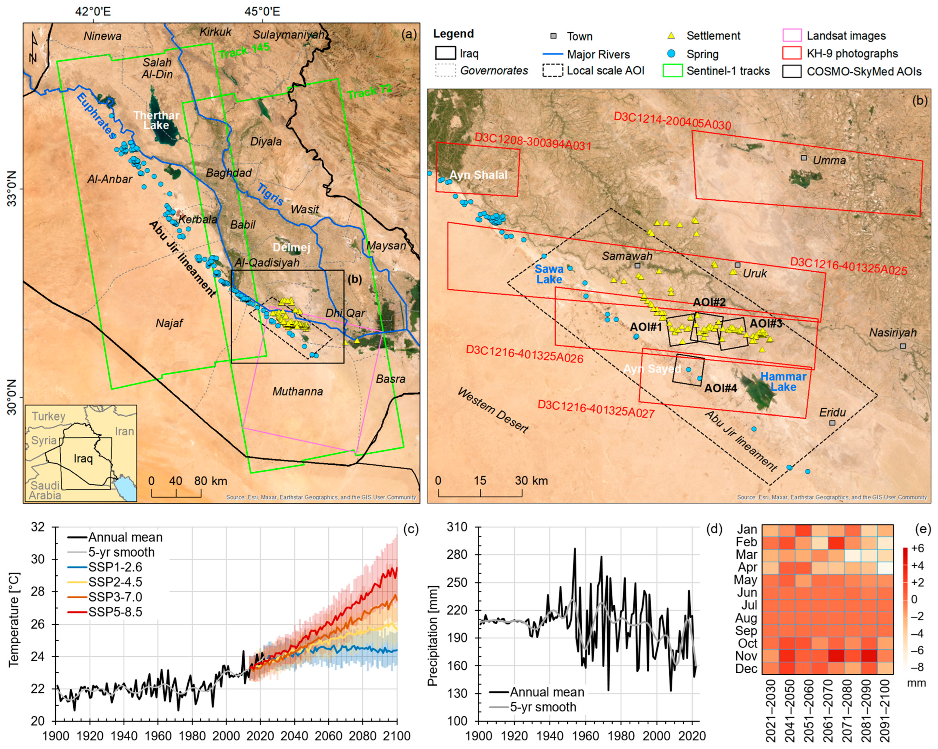
2.2. Recent and Projected Climate
3. Data and Methods
3.1. Satellite Data
3.2. Drone and Field Survey
3.3. Image Processing and Change Detection
4. Results
4.1. Regional-Scale Land Surface Processes
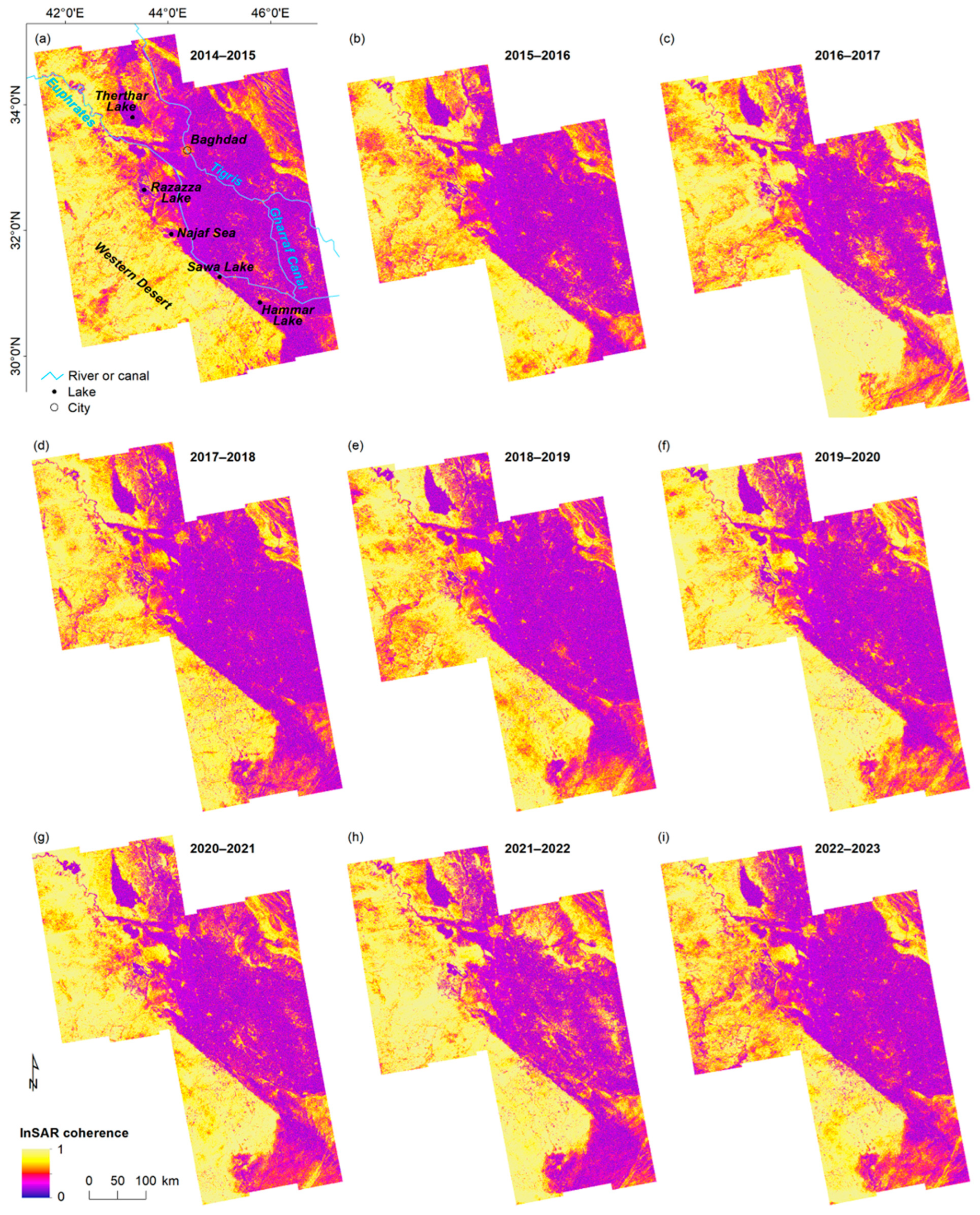
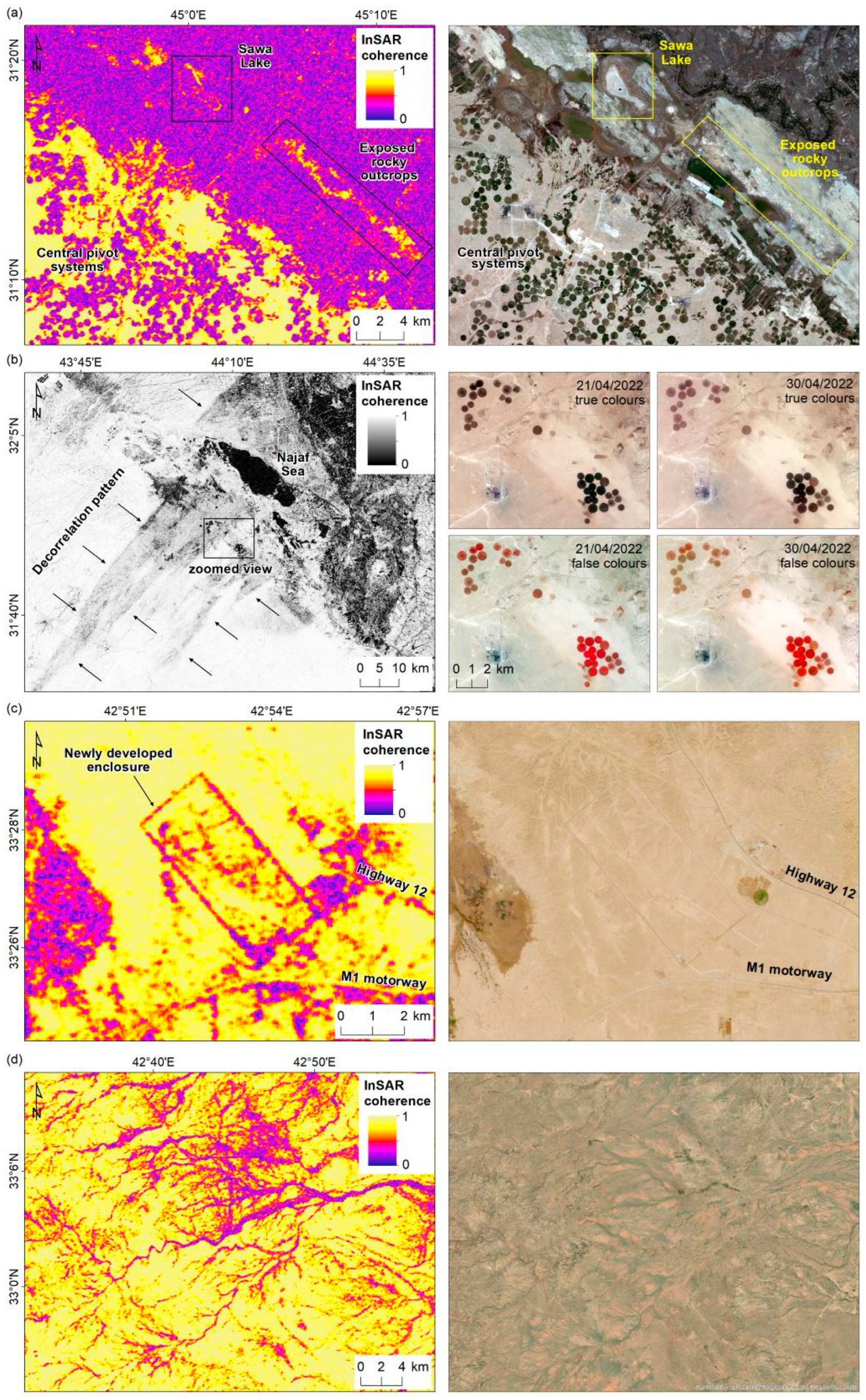
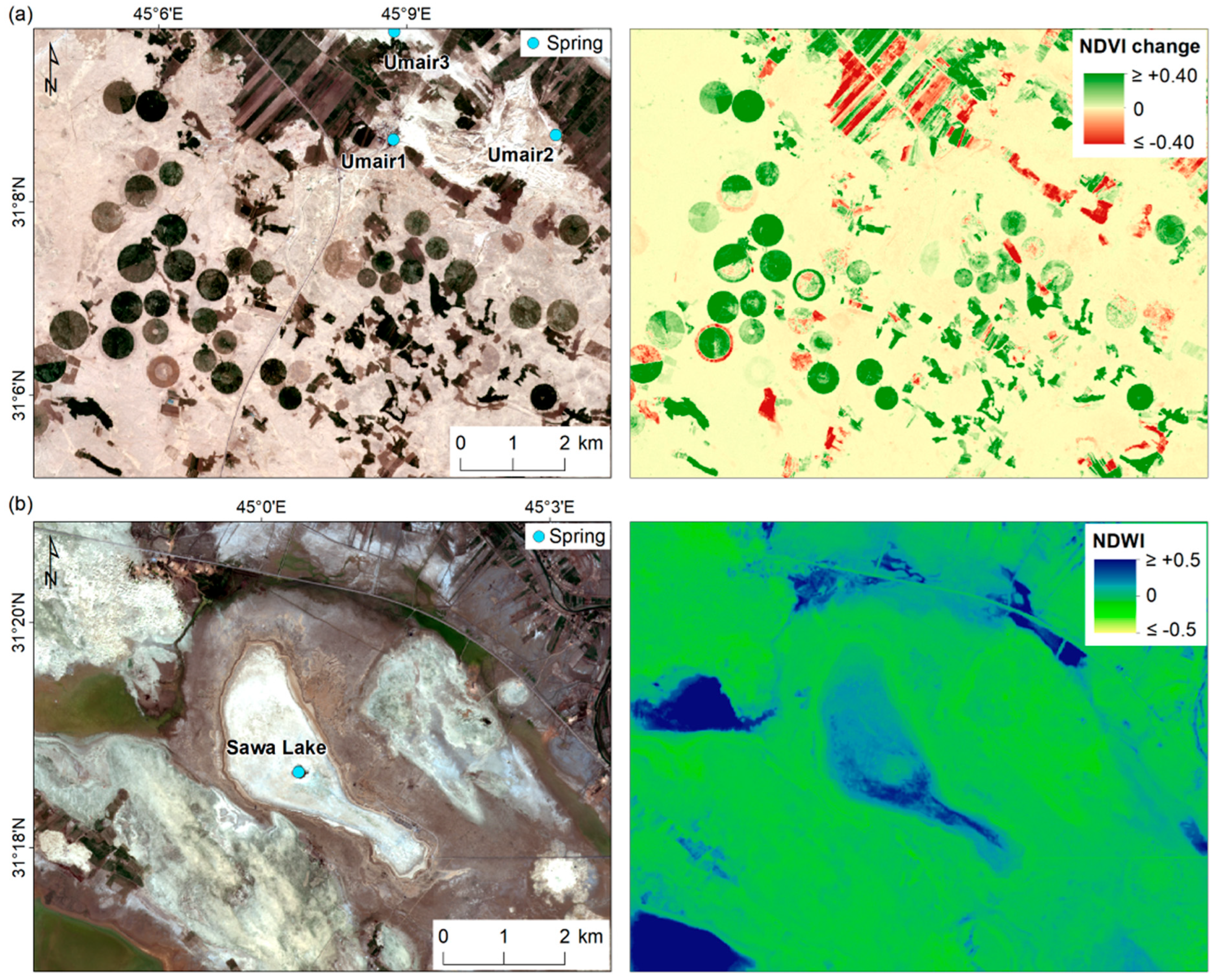
- Main water bodies (e.g., Therthar Lake, in the northern sector of the processed tracks; Figure 2a), which rapidly decorrelate due to the typical backscattering mechanism of water and, in some cases, due to the long-term changes in the extent of the surface of lakes that are progressively drying up, e.g., the recently documented disappearance of Sawa Lake [63], as depicted by a highly decorrelated pattern in 2021–2022 and the apparently dry lake bed in 2022 (Figure 3a).
- Land transformations linked with ongoing agricultural activities, the expansion of existing fields, the development of new ones (e.g., dense clusters of hundreds of modern centre-pivot irrigation systems, clearly indicated by the tens of decorrelating rounded features in Figure 3a; see also Section 4.2), or the abandonment of previously cultivated lands.
- Sand dune migration- and dust storm-related impacts on the agricultural landscape and human settlements, e.g., near the Najaf Sea and to its southwest (Figure 3b), where both yearly and short-temporal-scale γ maps clearly depict the medium-scale impact of the storm. Further confirmation is found in the PlanetScope data showing the layer of deposited sand that, soon after the dust storm event, covered the modern agricultural fields, which consequently appear brown to dark brown in the true-colour scenes and light brown to reddish in the false-colour scenes. Some of these fields, including one of the largest clusters, developed onto white patches of land that, in InSAR γ maps, generally appear as very-low-γ areas and correspond with northwest–southeast elongated geomorphological features that have yet to be fully interpreted by local geologists. Field observations suggest that these might be remnants of Holocene dunes, consisting of well-sorted and compacted sand (thanks to their salt content) that cannot migrate with the wind. A number of these features are found towards the southeast and reaching up to Hammar Lake (locally called ‘Slibiat Lake’).
- New urbanisation at the margins of the desert plateau and the development of manmade structures, e.g., a rectangular decorrelation feature crossing the former Al-Muhammadi airport runway at Abu Teban in the Al-Anbar governorate, indicating the construction of an enclosure in 2021–2022 (Figure 3c). This feature presumably delimits the site in which the new Anbar international airport for passenger transport and air cargo is currently under construction.
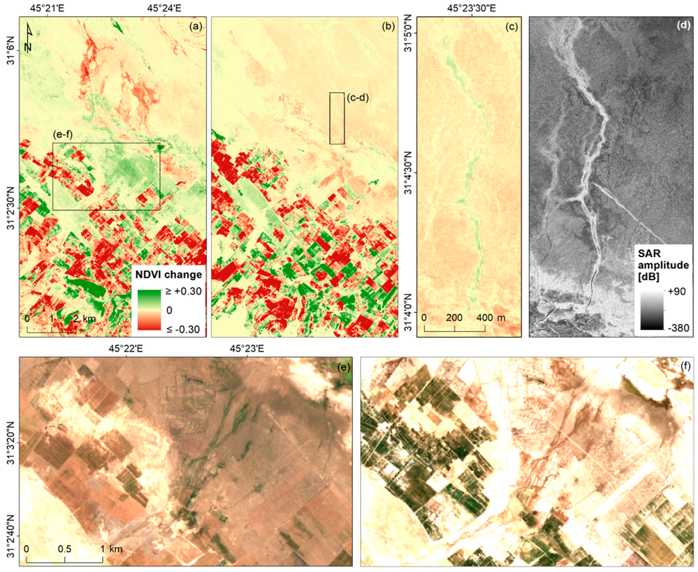
- Soil moisture variations along the fluvial network running across the desert that are almost invisible when using optical imagery, e.g., the river network west of Razazza Lake (Figure 3d).
4.2. Agricultural Practices and Water Use
4.3. Water Run-Off and Discharge
4.4. Modern vs. Vanishing Older Features
5. Discussion
5.1. The Nexus in Southern Iraq
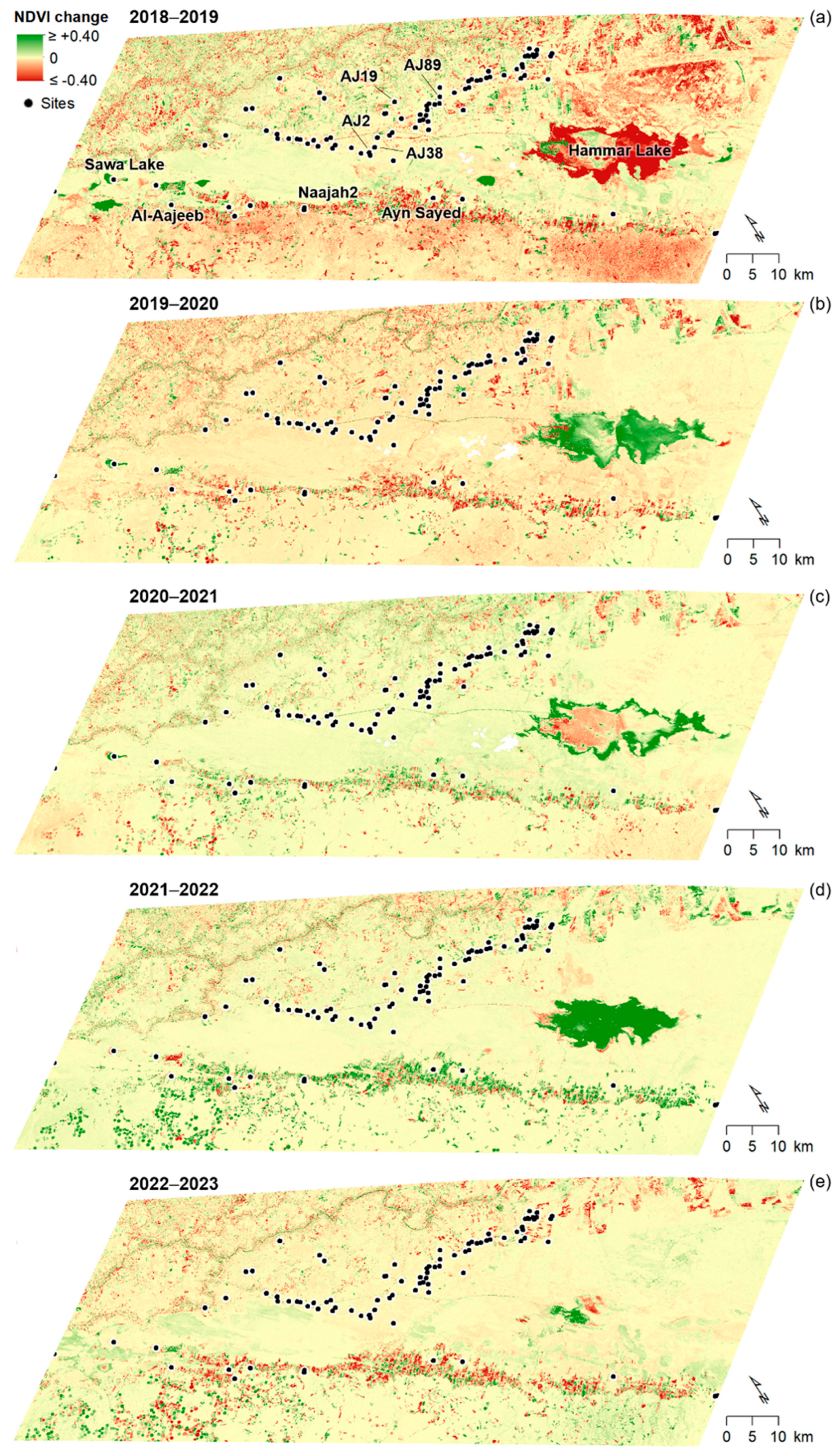
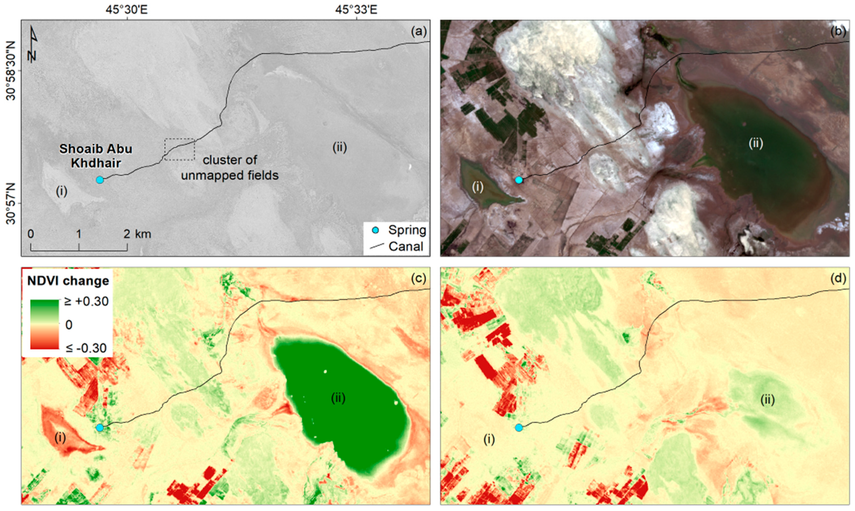
- Climate–Water: The decades-long increase in annual average mean surface air temperature and drop in annual precipitation (Figure 1c–e) led to significant water-level oscillations in surface reservoirs (e.g., Hammar Lake), drying out of lakes and contextual salinisation at the surface (e.g., Sawa Lake). Groundwater pumping was then increased along the Abu Jir lineament and the western sector of the study area to cope with the rising demand for water. However, as groundwater resources are overexploited, once they reach the surface, their excess is left to run-off and discharge, often into small to wide basins (e.g., Hammar Lake) or natural depressions. Given that these ephemeral water bodies are not potable/reusable due to water salinisation, a significant amount of water is lost in the overall hydraulic balance.
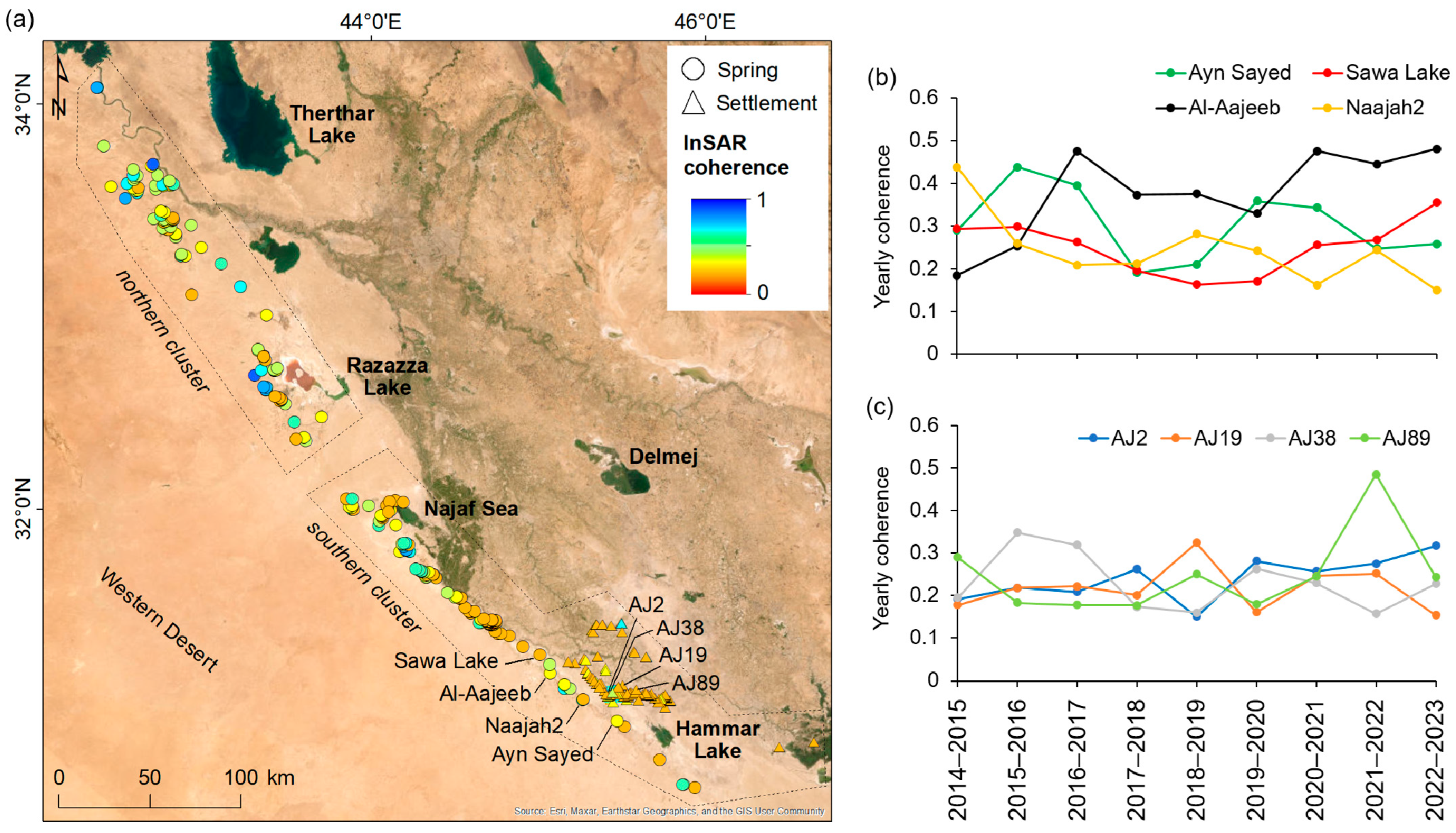
- Water–Agriculture: Other key drivers of groundwater overexploitation are industrial and intensive agriculture practices, which mostly rely on centre-pivot and/or herringbone irrigation systems fed by groundwater pumped by newly drilled wells. The springs that originally fed a wider region are now desiccating. Along the Abu Jir lineament, this process is concentrated amongst sprawls of agriculture, thus affecting the southern cluster of ancient sites between the Najaf Sea and Hammar Lake. These springs exhibit the strongest decorrelation (γ ~0.2 at 20 springs and 40 settlements) and the most obvious landscape transformations, including the drying up of major springs (e.g., Shoaib Abu Khdhair).
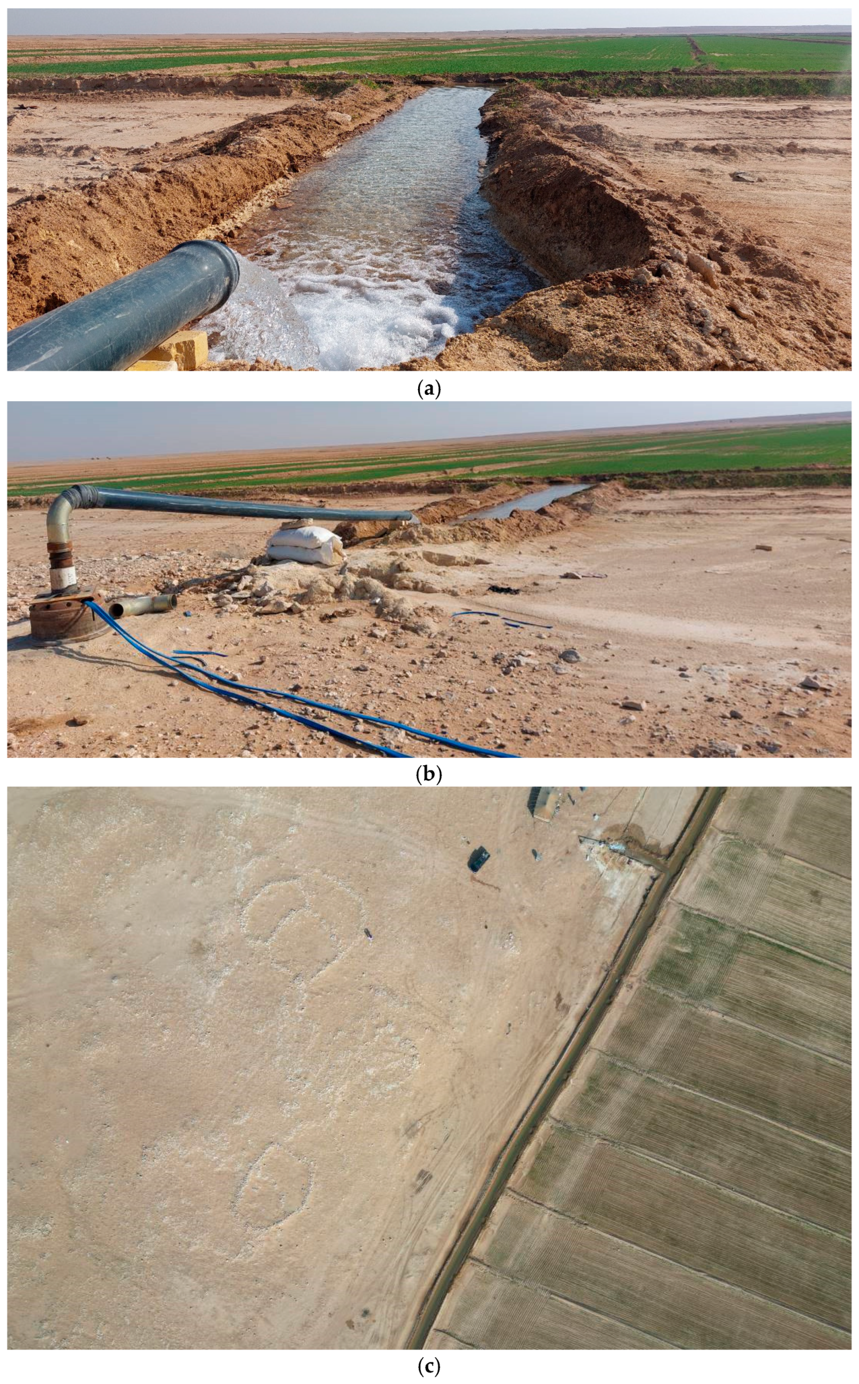
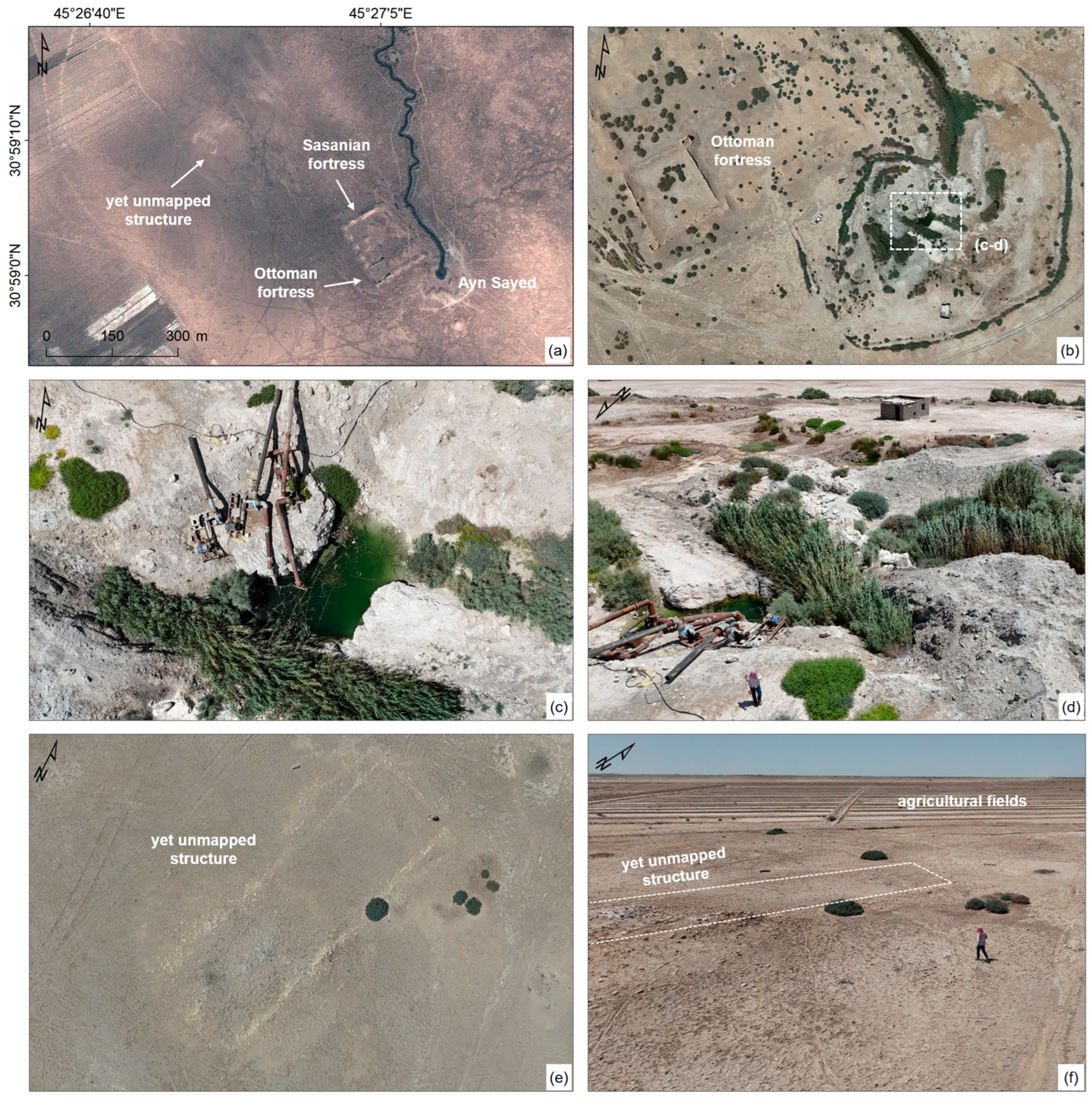
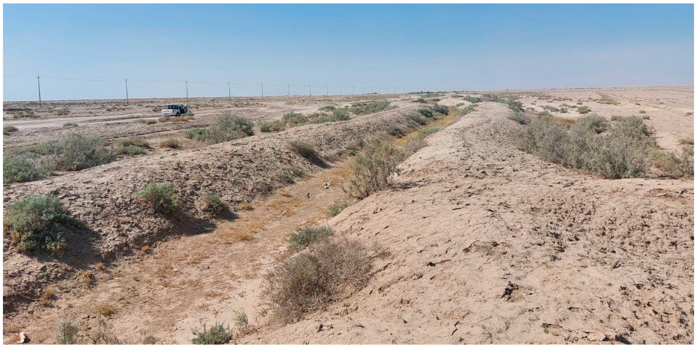
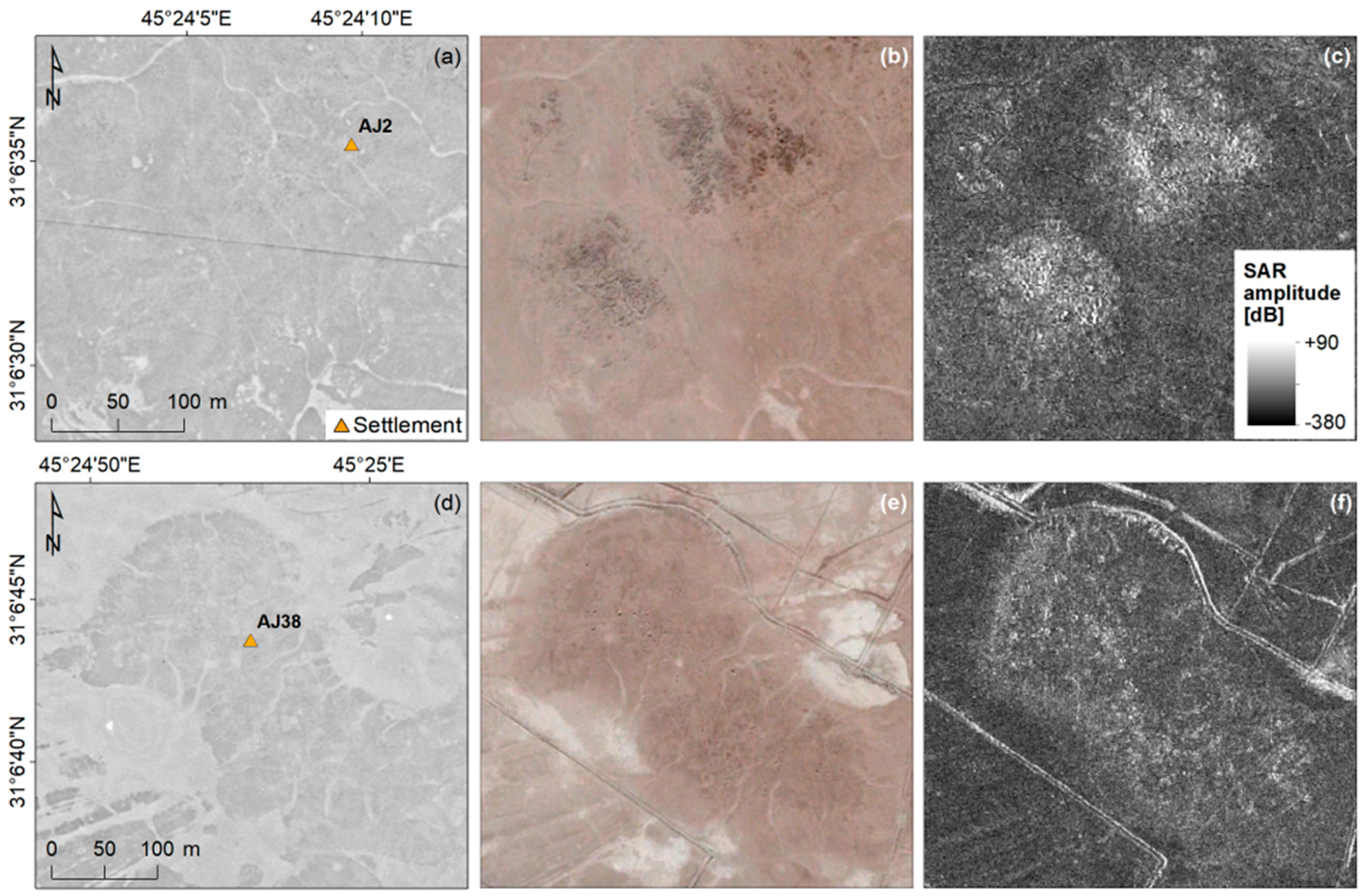
- Agriculture–Heritage: Contemporary agricultural practices are intensive and rely on the installation of infrastructure and/or digging of new canals that supersede and destroy traditional irrigation systems. In the western part of the study area, there is evidence of new wells at sourcing/water-capture points being dug close to the original springs. These operations cause significant disturbances to the former configuration of the ancient springs. Furthermore, new pumping stations installed at private properties allow for agricultural fields to expand to the extent that they approach, or even encroach on, archaeological sites, as in the case of the unmapped structure northwest of the Ayn Sayed spring. A similar dynamic was observed on the eastern side of the study area. Although there are examples such as that of site AJ38 (Figure 19), where agricultural activities do not always lead to the flattening/levelling of a site/mound (as observed, e.g., in other areas of Iraq and in Syria [70,72]), in other circumstances, such as those concerning incidents of looting in AOI#1, there is a spatial association of agricultural practice and the expansion of modern systems with the occurrence of looting.
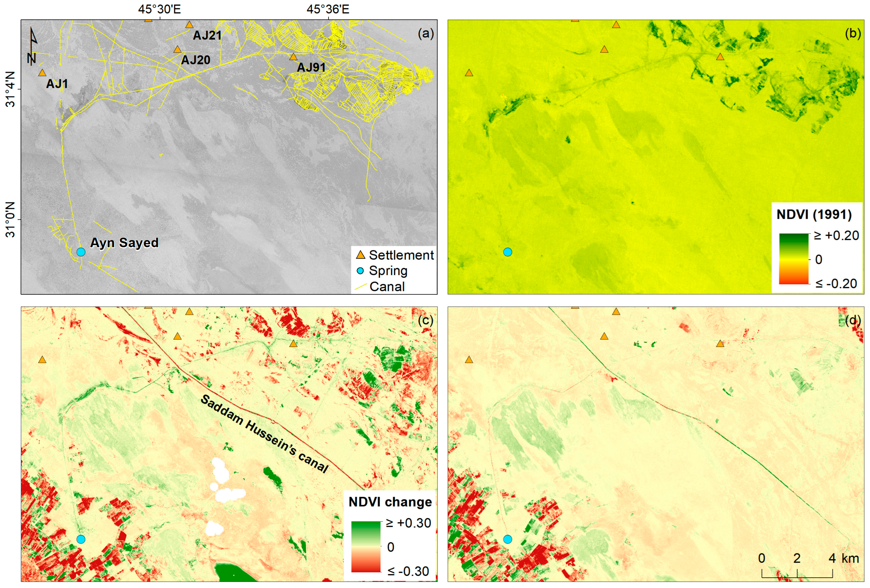
- Heritage–Water–Agriculture: As a consequence of the above process, through which ancient springs no longer reliably feed the traditional irrigation networks, farmers of downstream cropfields are forced to abandon the land. Therefore, canals that were once fully operational fall into disuse and, in time, are silted up. This nexus link therefore makes evident how a change in irrigation practice and alterations in the water supply systems can cause physical damage to tangible heritage (canals), a loss of intangible heritage (traditional agricultural practices that were undertaken for centuries), and social exclusion and inequality. A striking example is provided by the Ayn Sayed spring, which no longer provides water to the fields in the eastern sector of the Samawah province, with clear impacts on the local population. In some cases, entire villages (often with substantial heritage components) were made unliveable. This area is indeed one of the poorest in the whole country, and hosts farming communities and Bedouin pastoralists. As a result, pastoral and farming communities are migrating from the area [73]. Significant migration away from their home region has been documented for village and Bedouin populations; the latter is said to have decreased by 70% since 2003 [74]. This is a clear example of how satellite-derived environmental proxies can reveal societal impacts and, in this specific case, social inequality.
- Climate–Agriculture: The above-described abandonment process contributes to the increasing exposure to the impacts of desertification. Land abandonment occurs in the newly desertified areas highlighted by the satellite data and the previous literature [69]. This is apparent in the northern Muthanna and central Al-Qadisiyah governorates. Along the Abu Jir lineament, the population is attempting to survive the possible desertification trend through implementing intensive agriculture with centre-pivot and herringbone irrigation systems. Therefore, the nexus link between climate-forcing and agriculture practices encompasses two completely diverging patterns and trends, i.e., the shrinkage of agricultural land and the expansion of desertified areas and, on the other hand, the increase in agricultural exploitation, which leads to excessive groundwater abstraction and, thus, the unsustainable use of water. In this context, the impact due to dust storms must also be considered. Country-scale Sentinel-3 observations confirm the increased frequency of dust storms over the last few years (first images available in 2016), which is likely correlated with climate change and desertification. The latter is the outcome of a long process through which severe drought, a lack of rain, and the drying up of water bodies lead to the loss of vegetation and the exposure of significant amounts of sand and fine-grained deposits that can be mobilised. The event that occurred in April 2022, as seen in the Sentinel-1 coherence maps and PlanetScope imagery, provides clear evidence of the direct impact of storms on cultivated lands southwest of Najaf Sea. In addition to dust storms hitting the country from the west and northwest, increasingly desertified lands (e.g., the lands northwest of Eridu; Figure 8e–h) act as further sources of dust at the local scale. The existence of multiple sources of dust feeding the storms makes the implementation of mitigation initiatives aiming to reconvert desert into vegetative areas (e.g., the Ministry-funded “green this area” [75]) indispensable.
5.2. Categorisation of Satellite-Based Environmental Proxies
5.3. Comparability with Other Countries
5.4. Methodology Transferability
6. Conclusions
- The study provides, for the first time, a holistic understanding of the multiple intermingling processes that occur in this region. This is one of the most important contributions of this paper compared to the majority of previous studies—which either concentrated on specific Iraqi sites and often lacked a wider regional assessment or, vice versa, focused on a local-scale analysis but did not picture it in the broader context, or did not make comparisons between Iraq governorates.
- This study conducted a detailed investigation of the Abu Jir lineament and Eridu region, which have been poorly covered in the literature. The most up-to-date information about the current condition of springs that, today, are at risk of vanishing, alongside traditional agricultural systems, is provided. In particular, the extracted NDVI, NDWI, and InSAR coherence values show that the cluster of springs located between the Najaf Sea and Hammar Lake has been quite unstable over time, and is the area that is most affected by anthropogenic disturbances along the whole Abu Jir lineament. Not surprisingly, the western sector of the Samawah province in the Muthanna governorate is the area in which springs are declining and diminishing their water flow due to the overexploitation of groundwater by neighbouring farms and the proliferation of centre-pivot irrigation systems. The cascading effect is that the traditional agricultural fields located on the eastern side suffer from water scarcity. Satellite data show the abandonment of cropfields and destruction of older irrigation systems in favour of more modern, invasive networks of canals. These indicators act as proxies to identify areas where the local population was compelled to leave due to decreasing resource availability.
- This study categorizes the various processes based on the analysis and interpretation of the observed patterns related to single instances. For example, the chromatic tone changes and decorrelation in optical images and SAR coherence maps, respectively, are proxies of dust storm particle deposition and alterations in the surface properties of cropfields; NDVI, NDWI, and loss of InSAR coherence not only mark areas of the densification of industrial-scale agricultural practice and new centre-pivot irrigation systems, but also areas of water run-off and discharge into ephemeral bodies that detrimentally contribute to the non-optimised use of water resources.
- This study provides evidence of the side-effects resulting from land cover changes and the conversion of agricultural practices. In addition to the loss of traditional agricultural practices (local intangible cultural heritage), the investigation unveils several instances of damage to archaeological heritage sites (forts and structures) due to modern development. This process not only does not contribute to increasing resilience to the current climate crisis, but also implies a loss of cultural identity.
- Method’s transferability: The categorisation can be used as a practical matrix of interpretation keys to identify and track the processes contributing to this complex climate–water–agriculture–heritage nexus in other governorates of Iraq and other countries, to assess improvements in (or further deterioration of) the situation, if mitigation measures have been implemented (or not).
- Replicability: This method can be implemented in other countries (at least in the MENA region), by feasibly relying on similar satellite datasets, and may allow for comparative assessments and the identification of common or divergent trends.
- Awareness for future conservation: The evidence of detrimental impacts on water resources and negative encroachments onto cultural heritage preservation can stimulate further research into local resources and the necessary measures to mitigate the associated risk to conservation.
Author Contributions
Funding
Data Availability Statement
Acknowledgments
Conflicts of Interest
Appendix A
| Photograph ID | Mission | Date | Section | Processed Size | No. CPs | RMSE [m] | Locations |
|---|---|---|---|---|---|---|---|
| D3C1208-300394A031 | KH9-8 | 26/05/1974 | g | Full-frame | 8 | 2.77 | Ayn Shalal spring |
| D3C1214-200405A030 | KH9-14 | 03/05/1978 | e | Full-frame | 8 | 2.70 | Umma |
| f | Full-frame | 8 | 2.97 | ||||
| D3C1216-401325A025 | KH9-16 | 22/02/1981 | f | Crop | 8 | 2.74 | Sawa Lake, Uruk, Euphrates River |
| g | Crop | 9 | 2.24 | ||||
| h | Full-frame | 9 | 2.79 | ||||
| i | Full-frame | 8 | 1.81 | ||||
| D3C1216-401325A026 | KH9-16 | 22/02/1981 | f | Crop | 8 | 2.12 | AOI#1, AOI#2, AOI#3 |
| g | Full-frame | 8 | 2.92 | ||||
| Small crop | 8 | 2.62 | |||||
| h | Full-frame | 8 | 2.61 | ||||
| D3C1216-401325A027 | KH9-16 | 22/02/1981 | f | Crop | 10 | 2.43 | Hammar Lake, AOI#4—Ayn Sayed spring |
| g | Crop | 9 | 1.53 | ||||
| Small crop | 8 | 1.44 |
| Path | Dates | Bt [Days] | Bp [m] | No. Scenes |
|---|---|---|---|---|
| 145 | 15/10/2014–03/11/2015 | 384 | –4 | 3 |
| 15/11/2015–09/11/2016 | 360 | 10 | 2 | |
| 03/12/2016–28/11/2017 | 360 | 2 | 2 | |
| 28/12/2017–11/12/2018 | 348 | 4 | 2 | |
| 17/12/2018–12/12/2019 | 360 | 2 | 2 | |
| 18/12/2019–18/12/2020 | 366 | –3 | 3 | |
| 24/12/2020–19/12/2021 | 360 | –14 | 2 | |
| 25/12/2021–08/12/2022 | 348 | 8 | 2 | |
| 20/12/2022–27/12/2023 | 372 | 35 | 2 | |
| 72 | 10/10/2014–29/10/2015 | 384 | –48 | 3 |
| 22/11/2015–16/11/2016 | 360 | 12 | 3 | |
| 28/11/2016–11/11/2017 | 348 | –60 | 3 | |
| 23/11/2017–18/11/2018 | 360 | 37 | 3 | |
| 30/11/2018–07/12/2019 | 372 | 22 | 3 | |
| 19/12/2019–13/12/2020 | 360 | 62 | 3 | |
| 25/12/2020–20/12/2021 | 360 | –17 | 3 | |
| 20/12/2021–15/12/2022 | 360 | –11 | 3 | |
| 15/12/2022–10/12/2023 | 360 | –36 | 3 |
| Path | Dates | Bt [days] | Bp [m] |
|---|---|---|---|
| 145 | 31/03/2022–12/04/2022 | 12 | 15 |
| 24/04/2022–30/05/2022 | 36 | 43 | |
| 24/04/2022–06/05/2022 | 12 | 163 | |
| 06/05/2022–18/05/2022 | 12 | 19 | |
| 18/05/2022–30/05/2022 | 12 | –140 | |
| 30/05/2022–11/06/2022 | 12 | –2 |
| Composite (MM/YYYY) | Dates | No. Tiles |
|---|---|---|
| 12/2018 | 15/12/2018, 25/12/2018, 30/12/2018 | 10 |
| 07/2019 | 03/07/2019, 05/07/2019, 08/07/2019, 10/07/2019, 13/07/2019, 15/07/2019, 18/07/2019, 20/07/2019, 23/07/2019, 25/07/2019, 28/07/2019, 30/07/2019 | 18 |
| 12/2019 | 05/12/2019, 15/12/2019, 17/12/2019, 20/12/2019, 22/12/2019, 30/12/2019 | 14 |
| 07/2020 | 02/07/2020, 04/07/2020, 07/07/2020, 09/07/2020, 12/07/2020, 17/07/2020, 19/07/2020, 24/07/2020, 27/07/2020, 29/07/2020 | 25 |
| 12/2020 | 01/12/2020, 09/12/2020, 11/12/2020, 14/12/2020, 21/12/2020, 24/12/2020 | 15 |
| 07/2021 | 02/07/2021, 04/07/2021, 07/07/2021, 09/07/2021, 12/07/2021, 14/07/2021, 17/07/2021, 22/07/2021, 24/07/2021, 27/07/2021 | 21 |
| 12/2021 | 06/12/2021, 09/12/2021, 19/12/2021 | 7 |
| 07/2022 | 02/07/2022, 04/07/2022, 07/07/2022, 09/07/2022, 14/07/2022, 17/07/2022, 19/07/2022, 22/07/2022, 24/07/2022 | 20 |
| 12/2022 | 11/12/2022, 16/12/2022, 19/12/2022, 21/12/2022, 29/12/2022 | 15 |
| 07/2023 | 02/07/2023, 04/07/2023, 07/07/2023, 09/07/2023, 12/07/2023, 14/07/2023, 17/07/2023, 19/07/2023, 24/07/2023, 27/07/2023, 29/07/2023 | 32 |
| 12/2023 | 01/12/2023, 04/12/2023, 14/12/2023, 16/12/2023, 19/12/2023, 21/12/2023, 24/12/2023, 26/12/2023 | 25 |
| 07/2024 | 01/07/2024, 03/07/2024, 08/07/2024, 11/07/2024, 13/07/2024, 16/07/2024, 18/07/2024, 21/07/2024, 23/07/2024, 26/07/2024, 28/07/2024 | 32 |
| AOI#1 (Western) Beam ES-33 (50.6° Look Angle, 57.7° θ) Ascending Mode | AOI#2 (central) Beam ES-17 (39.5° Look Angle, 44.2° θ) Descending Mode | AOI#3 (Eastern) Beam ES-25 (46.2° Look Angle, 52.5° θ) Ascending Mode | AOI#4 (Ayn Sayed) Beam ES33 (50.6° Look Angle, 57.8° θ) Descending Mode | ||||
|---|---|---|---|---|---|---|---|
| Satellite | Date | Satellite | Date | Satellite | Date | Satellite | Date |
| CSK4 | 03/12/2023 | CSK2 | 28/11/2023 | CSK1 | 01/12/2023 | CSK2 | 08/12/2023 |
| CSK2 | 04/12/2023 | CSK1 | 06/12/2023 | CSK4 | 08/12/2023 | CSK4 | 08/01/2024 |
| CSK1 | 12/12/2023 | CSK1 | 22/12/2023 | CSK2 | 09/12/2023 | CSK2 | 09/01/2024 |
| CSK4 | 19/12/2023 | CSK1 | 07/01/2024 | CSK1 | 17/12/2023 | CSK2 | 10/02/2024 |
| CSK2 | 20/12/2023 | CSK4 | 14/01/2024 | CSK4 | 24/12/2023 | CSK2 | 26/02/2024 |
| CSK1 | 28/12/2023 | CSK2 | 15/01/2024 | CSK2 | 25/12/2023 | CSK4 | 12/03/2024 |
| CSK4 | 04/01/2024 | CSK4 | 30/01/2024 | CSK1 | 02/01/2024 | CSK2 | 13/03/2024 |
| CSK2 | 05/01/2024 | CSK2 | 31/01/2024 | CSK4 | 09/01/2024 | CSK2 | 29/03/2024 |
| CSK1 | 13/01/2024 | CSK1 | 08/02/2024 | CSK2 | 10/01/2024 | CSK2 | 14/04/2024 |
| CSK4 | 20/01/2024 | CSK2 | 16/02/2024 | CSK1 | 18/01/2024 | CSK2 | 03/07/2024 |
| CSK2 | 21/01/2024 | CSK4 | 02/03/2024 | CSK1 | 03/02/2024 | CSK2 | 05/09/2024 |
| CSK1 | 29/01/2024 | CSK2 | 03/03/2024 | CSK4 | 10/02/2024 | CSK4 | 06/10/2024 |
| CSK4 | 05/02/2024 | CSK4 | 18/03/2024 | CSK2 | 11/02/2024 | CSK2 | 07/10/2024 |
| CSK2 | 06/02/2024 | CSK2 | 19/03/2024 | CSK1 | 19/02/2024 | CSK4 | 22/10/2024 |
| CSK1 | 14/02/2024 | CSK4 | 03/04/2024 | CSK1 | 06/03/2024 | CSK4 | 07/11/2024 |
| CSK4 | 21/02/2024 | CSK2 | 04/04/2024 | CSK4 | 13/03/2024 | CSK2 | 08/11/2024 |
| CSK2 | 22/02/2024 | CSK1 | 12/04/2024 | CSK4 | 29/03/2024 | ||
| CSK1 | 01/03/2024 | CSK4 | 19/04/2024 | CSK2 | 30/03/2024 | ||
| CSK4 | 08/03/2024 | CSK1 | 28/04/2024 | CSK1 | 07/04/2024 | ||
| CSK2 | 09/03/2024 | CSK4 | 05/05/2024 | CSK4 | 14/04/2024 | ||
| CSK1 | 17/03/2024 | CSK2 | 06/05/2024 | CSK2 | 15/04/2024 | ||
| CSK1 | 02/04/2024 | CSK1 | 14/05/2024 | CSK2 | 01/05/2024 | ||
| CSK4 | 09/04/2024 | CSK1 | 30/05/2024 | CSK2 | 17/05/2024 | ||
| CSK2 | 10/04/2024 | CSK4 | 06/06/2024 | CSK2 | 02/06/2024 | ||
| CSK1 | 18/04/2024 | CSK2 | 07/06/2024 | CSK1 | 10/06/2024 | ||
| CSK1 | 04/05/2024 | CSK1 | 15/06/2024 | CSK2 | 18/06/2024 | ||
| CSK4 | 11/05/2024 | CSK2 | 23/06/2024 | CSK4 | 03/07/2024 | ||
| CSK2 | 12/05/2024 | CSK1 | 01/07/2024 | CSK2 | 04/07/2024 | ||
| CSK4 | 27/05/2024 | CSK4 | 08/07/2024 | CSK1 | 12/07/2024 | ||
| CSK2 | 28/05/2024 | CSK2 | 09/07/2024 | CSK2 | 20/07/2024 | ||
| CSK1 | 05/06/2024 | CSK1 | 17/07/2024 | CSK1 | 28/07/2024 | ||
| CSK4 | 12/06/2024 | CSK4 | 24/07/2024 | CSK4 | 04/08/2024 | ||
| CSK2 | 13/06/2024 | CSK2 | 25/07/2024 | CSK2 | 05/08/2024 | ||
| CSK4 | 28/06/2024 | CSK1 | 02/08/2024 | CSK1 | 13/08/2024 | ||
| CSK2 | 29/06/2024 | CSK4 | 09/08/2024 | CSK1 | 29/08/2024 | ||
| CSK1 | 07/07/2024 | CSK2 | 10/08/2024 | CSK4 | 05/09/2024 | ||
| CSK4 | 14/07/2024 | CSK4 | 25/08/2024 | CSK2 | 06/09/2024 | ||
| CSK2 | 15/07/2024 | CSK2 | 26/08/2024 | CSK4 | 21/09/2024 | ||
| CSK4 | 30/07/2024 | CSK1 | 03/09/2024 | CSK1 | 30/09/2024 | ||
| CSK2 | 31/07/2024 | CSK4 | 10/09/2024 | CSK4 | 07/10/2024 | ||
| CSK1 | 08/08/2024 | CSK2 | 11/09/2024 | CSK2 | 08/10/2024 | ||
| CSK4 | 15/08/2024 | CSK4 | 26/09/2024 | CSK4 | 23/10/2024 | ||
| CSK2 | 16/08/2024 | CSK2 | 27/09/2024 | CSK2 | 24/10/2024 | ||
| CSK1 | 24/08/2024 | CSK1 | 05/10/2024 | CSK4 | 08/11/2024 | ||
| CSK4 | 31/08/2024 | CSK4 | 12/10/2024 | CSK2 | 25/11/2024 | ||
| CSK2 | 01/09/2024 | CSK2 | 13/10/2024 | ||||
| CSK1 | 09/09/2024 | CSK1 | 21/10/2024 | ||||
| CSK2 | 17/09/2024 | CSK4 | 28/10/2024 | ||||
| CSK1 | 25/09/2024 | CSK2 | 29/10/2024 | ||||
| CSK4 | 02/10/2024 | CSK1 | 06/11/2024 | ||||
| CSK2 | 03/10/2024 | CSK1 | 22/11/2024 | ||||
| CSK1 | 11/10/2024 | CSK4 | 29/11/2024 | ||||
| CSK1 | 27/10/2024 | ||||||
| CSK4 | 03/11/2024 | ||||||
| CSK2 | 04/11/2024 | ||||||
| CSK1 | 12/11/2024 | ||||||
| CSK4 | 19/11/2024 | ||||||
| CSK2 | 20/11/2024 | ||||||
| CSK1 | 28/11/2024 | ||||||
References
- Roldán-Cañas, J.; Moreno-Pérez, M.F. Water and Irrigation Management in Arid and Semiarid Zones. Water 2021, 13, 2446. [Google Scholar] [CrossRef]
- Nelson, G.C.; Bennett, E.; Berhe, A.A.; Cassman, K.; DeFries, R.; Dietz, T.; Dobermann, A.; Dobson, A.; Janetos, A.; Levy, M.; et al. Anthropogenic drivers of ecosystem change: An overview. Ecol. Soc. 2006, 11, 29. [Google Scholar] [CrossRef]
- van den Heuvel, L.; Blicharska, M.; Masia, S.; Sušnik, J.; Teutschbein, C. Ecosystem services in the Swedish water-energy-food-land-climate nexus: Anthropogenic pressures and physical interactions. Ecosyst. Serv. 2020, 44, 101141. [Google Scholar] [CrossRef]
- Marinelli, E.; Radini, S.; Akyol, Ç.; Sgroi, M.; Eusebi, A.L.; Bischetti, G.B.; Mancini, A.; Fatone, F. Water-Energy-Food-Climate Nexus in an Integrated Peri-Urban Wastewater Treatment and Reuse System: From Theory to Practice. Sustainability 2021, 13, 10952. [Google Scholar] [CrossRef]
- Lucca, E.; El Jeitany, J.; Castelli, G.; Pacetti, T.; Bresci, E.; Nardi, F.; Caporali, E. A review of water-energy-food-ecosystems Nexus research in the Mediterranean: Evolution, gaps and applications. Environ. Res. Lett. 2023, 18, 83001. [Google Scholar] [CrossRef]
- FAO. Water Efficiency, Productivity and Sustainability in the NENA Regions (WEPS-NENA). Available online: https://www.fao.org/in-action/water-efficiency-nena/activities/nexus-framework/en/ (accessed on 15 December 2024).
- NDC. The Water-Climate Nexus: Tackling the Growing Risk of Water-Related Crises. Available online: https://ndcpartnership.org/news/water-climate-nexus-tackling-growing-risk-water-related-crises (accessed on 15 December 2024).
- Sesana, E.; Gagnon, A.S.; Ciantelli, C.; Cassar, J.; Hughes, J.J. Climate change impacts on cultural heritage: A literature review. WIREs Clim. Change 2021, 12, e710. [Google Scholar] [CrossRef]
- Britwum, K.; Demont, M. Food security and the cultural heritage missing link. Glob. Food Sec. 2022, 35, 100660. [Google Scholar] [CrossRef]
- Eriksson, O. Coproduction of Food, Cultural Heritage and Biodiversity by Livestock Grazing in Swedish Semi-natural Grasslands. Front. Sustain. Food Syst. 2022, 6, 801327. [Google Scholar] [CrossRef]
- Daugstad, K.; Rønningen, K.; Skar, B. Agriculture as an upholder of cultural heritage? Conceptualizations and value judgements—A Norwegian perspective in international context. J. Rural Stud. 2006, 22, 67–81. [Google Scholar] [CrossRef]
- Ardakanian, R.; Hülsmann, S. Impact of Global Change on World Heritage and on Environmental Resources: The Need for an Integrated Management Approach. In Climate Change as a Threat to Peace: Impacts on Cultural Heritage and Cultural Diversity; von Schorlemer, S., Maus, S., Eds.; Peter Lang Verlag: Berlin, Germany, 2015; pp. 101–117. ISBN 9783653052053. [Google Scholar]
- UNEP. Global Environment Outlook—GEO-6: Healthy Planet, Healthy People; UN Environment, Ed.; Cambridge University Press: Cambridge, UK, 2019; ISBN 9781108627146. [Google Scholar]
- IOM Iraq. Migration, Environment and Climate Change in Iraq; IOM Iraq: Baghdad, Iraq, 2022. [Google Scholar]
- MoE. “The Ahwar” Marshlands of Southern Iraq; MoE: Baghdad, Iraq, 2014. [Google Scholar]
- Hashim, B.M.; Sultan, M.A.; Attyia, M.N.; Al Maliki, A.A.; Al-Ansari, N. Change detection and impact of climate changes to Iraqi southern marshes using Landsat 2 MSS, Landsat 8 OLI and Sentinel 2 MSI data and GIS applications. Appl. Sci. 2019, 9, 2016. [Google Scholar] [CrossRef]
- Kadhim, M.M. Monitoring land cover change using remote sensing and GIS techniques: A case study of Al-Dalmaj marsh, Iraq. J. Eng. 2018, 24, 96–108. [Google Scholar] [CrossRef]
- Al-Helaly, M.; Alwan, I.; AL-Hameedawi, A. Environmental investigation of Bahar Al-Najaf region using Sentinel-2 images. Eng. Technol. J. 2022, 40, 732–742. [Google Scholar] [CrossRef]
- Jumaah, H.J.; Ameen, M.H.; Mohamed, G.H.; Ajaj, Q.M. Monitoring and evaluation Al-Razzaza lake changes in Iraq using GIS and remote sensing technology. Egypt. J. Remote Sens. Sp. Sci. 2022, 25, 313–321. [Google Scholar] [CrossRef]
- Wdaah, E.R.; Nori, A.F. Detection of land cover change in the Sea of Najaf/Iraq for the period (2005–2022) using remote sensing techniques. Int. J. Adv. Multidiscip. Res. Stud. 2023, 3, 1201–1206. [Google Scholar]
- Hritz, C.; Wilkinson, T.J. Using Shuttle Radar Topography to map ancient water channels in Mesopotamia. Antiquity 2006, 80, 415–424. [Google Scholar] [CrossRef]
- Wilkinson, T.J.; Rayne, L.; Jotheri, J. Hydraulic landscapes in Mesopotamia: The role of human niche construction. Water Hist. 2015, 7, 397–418. [Google Scholar] [CrossRef]
- Jotheri, J.; Allen, M.B. Recognition of ancient channels and archaeological sites in the Mesopotamian floodplain using satellite imagery and digital topography. In New Agendas in Remote Sensing and Landscape Archaeology in the Near East: Studies in Honour of Tony J. Wilkinson; Lawrence, D., Altaweel, M., Philip, G., Eds.; Archaeopress: Oxford, UK, 2020; pp. 283–305. ISBN 9781789695731. [Google Scholar]
- Webb, J.A.; Jotheri, J.; Fensham, R.J. Springs of the Arabian desert: Hydrogeology and hydrochemistry of Abu Jir springs, Central Iraq. Water 2024, 16, 2491. [Google Scholar] [CrossRef]
- Cigna, F.; Tapete, D.; Rayne, L.; Makovics, J.L.; Irvine, H.K.; De Gruchy, M.W.; Jotheri, J. Assessing anthropogenic and climate change threats to archaeological landscapes in Iraq using Earth observation. In Proceedings of the 2024 IEEE Mediterranean and Middle-East Geoscience and Remote Sensing Symposium, M2GARSS 2024, Oran, Algeria, 15–17 April 2024; pp. 424–428. [Google Scholar]
- Saleh, S.A.; Al-Ansari, N.; Abdullah, T. Groundwater hydrology in Iraq. J. Earth Sci. Geotech. Eng. 2020, 10, 155–197. [Google Scholar]
- Algabri, A. Settlement Patterns in the West of Uruk During the Second Millennium BC. Master’s Thesis, University of Al-Qadisiyah, Al-Qadisiyah, Iraq, 2020. [Google Scholar]
- World Bank Climate Change Overview > Country Summary: Iraq. Available online: https://climateknowledgeportal.worldbank.org/country/iraq (accessed on 15 December 2024).
- Hewett, Z.; de Gruchy, M.; Hill, D.; Lawrence, D. Raincheck: A new diachronic series of rainfall maps for Southwest Asia over the Holocene. Levant 2022, 54, 5–28. [Google Scholar] [CrossRef]
- Jotheri, J.; Rokan, M.; Al-Ghanim, A.; Rayne, L.; de Gruchy, M.; Alabdan, R. Identifying the preserved network of irrigation canals in the Eridu region, southern Mesopotamia. Antiquity 2025, 1–7. [Google Scholar] [CrossRef]
- Colombera, L.; Mountney, N.P. Influence of fluvial crevasse-splay deposits on sandbody connectivity: Lessons from geological analogues and stochastic modelling. Mar. Pet. Geol. 2021, 128, 105060. [Google Scholar] [CrossRef]
- Adams, R.M. Heartland of cities: Surveys of Ancient Settlement and Land Use on the Central Floodplain of the Euphrates; University of Chicago Press: Chicago, IL, USA, 1981. [Google Scholar]
- Jotheri, J.; Allen, M.B.; Wilkinson, T.J. Holocene avulsions of the Euphrates River in the Najaf area of Western Mesopotamia: Impacts on human settlement patterns. Geoarchaeology 2016, 31, 175–193. [Google Scholar] [CrossRef]
- Köppen, W. Das Geographische System der Klimate; Gebrüder Borntraeger: Berlin, Germany, 1936. [Google Scholar]
- Pressel, P. Meeting the challenge: The HEXAGON KH-9 Reconnaissance Satellite; American Institute of Aeronautics and Astronautics: Reston, VA, USA, 2013; ISBN 978-1624102035. [Google Scholar]
- CSNR. HEXAGON America’s Eyes in Space—Fact Sheet. Center for the Study of National Reconnaissance; CSNR: Chantilly, VA, USA, 2011. [Google Scholar]
- Hammer, E.; FitzPatrick, M.; Ur, J. Succeeding CORONA: Declassified HEXAGON intelligence imagery for archaeological and historical research. Antiquity 2022, 96, 679–695. [Google Scholar] [CrossRef]
- EROS. Declassified Satellite Imagery—3. United States Geological Survey (USGS), Earth Resources Observation and Science (EROS) Center 2017. Available online: https://www.usgs.gov/centers/eros/science/usgs-eros-archive-declassified-data-declassified-satellite-imagery-3 (accessed on 15 December 2024).
- Torres, R.; Snoeij, P.; Geudtner, D.; Bibby, D.; Davidson, M.; Attema, E.; Potin, P.; Rommen, B.Ö.; Floury, N.; Brown, M.; et al. GMES Sentinel-1 mission. Remote Sens. Environ. 2012, 120, 9–24. [Google Scholar] [CrossRef]
- Drusch, M.; Del Bello, U.; Carlier, S.; Colin, O.; Fernandez, V.; Gascon, F.; Hoersch, B.; Isola, C.; Laberinti, P.; Martimort, P.; et al. Sentinel-2: ESA’s optical high-resolution mission for GMES operational services. Remote Sens. Environ. 2012, 120, 25–36. [Google Scholar] [CrossRef]
- Caltagirone, F.; Capuzi, A.; Coletta, A.; De Luca, G.F.; Scorzafava, E.; Leonardi, R.; Rivola, S.; Fagioli, S.; Angino, G.; Labbate, M.; et al. The COSMO-SkyMed dual use earth observation program: Development, qualification, and results of the commissioning of the overall constellation. IEEE J. Sel. Top. Appl. Earth Obs. Remote Sens. 2014, 7, 2754–2762. [Google Scholar] [CrossRef]
- Covello, F.; Battazza, F.; Coletta, A.; Lopinto, E.; Fiorentino, C.; Pietranera, L.; Valentini, G.; Zoffoli, S. COSMO-SkyMed an existing opportunity for observing the Earth. J. Geodyn. 2010, 49, 171–180. [Google Scholar] [CrossRef]
- Tapete, D.; Traviglia, A.; Delpozzo, E.; Cigna, F. Regional-scale systematic mapping of archaeological mounds and detection of looting using COSMO-SkyMed high resolution DEM and satellite imagery. Remote Sens. 2021, 13, 3106. [Google Scholar] [CrossRef]
- ASI COSMO-SkyMed Mission and Products Description (8 July 2019). Italian Space Agency—ASI. DOC n. ASI-CSM-PMG-NT-001, 151p. Available online: https://www.asi.it/wp-content/uploads/2019/08/COSMO-SkyMed-Mission-and-Products-Description_rev3-1.pdf (accessed on 15 December 2024).
- Donlon, C.; Berruti, B.; Buongiorno, A.; Ferreira, M.H.; Féménias, P.; Frerick, J.; Goryl, P.; Klein, U.; Laur, H.; Mavrocordatos, C.; et al. The Global Monitoring for Environment and Security (GMES) Sentinel-3 mission. Remote Sens. Environ. 2012, 120, 37–57. [Google Scholar] [CrossRef]
- Farr, T.G.; Rosen, P.A.; Caro, E.; Crippen, R.; Duren, R.; Hensley, S.; Kobrick, M.; Paller, M.; Rodriguez, E.; Roth, L.; et al. The shuttle radar topography mission. Rev. Geophys. 2007, 45, RG2004. [Google Scholar] [CrossRef]
- Makovics, J.L. Utilising declassified Cold War satellite imagery (KH-9 HEXAGON) for remote sensing of historic hydraulic management features in North Africa. In Proceedings of the 2024 IEEE Mediterranean and Middle-East Geoscience and Remote Sensing Symposium, M2GARSS 2024, Oran, Algeria, 15–17 April 2024; pp. 391–395. [Google Scholar]
- Rosen, P.A.; Hensley, S.; Joughin, I.R.; Li, F.K.; Madsen, S.N.; Rodriguez, E.; Goldstein, R.M. Synthetic aperture radar interferometry. Proc. IEEE 2000, 88, 333–380. [Google Scholar] [CrossRef]
- Hogenson, K.; Kristenson, H.; Kennedy, J.; Johnston, A.; Rine, J.; Logan, T.; Zhu, J.; Williams, F.; Herrmann, J.; Smale, J.; et al. Hybrid Pluggable Processing Pipeline (HyP3): A Cloud-Based Infrastructure for Generic Processing of SAR Data 2020. Available online: https://zenodo.org/records/15299601 (accessed on 15 December 2024).
- Prats-Iraola, P.; Scheiber, R.; Marotti, L.; Wollstadt, S.; Reigber, A. TOPS interferometry with TerraSAR-X. IEEE Trans. Geosci. Remote Sens. 2012, 50, 3179–3188. [Google Scholar] [CrossRef]
- Goldstein, R.M.; Werner, C.L. Radar interferogram filtering for geophysical applications. Geophys. Res. Lett. 1998, 25, 4035–4038. [Google Scholar] [CrossRef]
- Copernicus Copernicus DEM—Global and European Digital Elevation Model (COP-DEM)—GLO-30 2024. Available online: https://dataspace.copernicus.eu/explore-data/data-collections/copernicus-contributing-missions/collections-description/COP-DEM (accessed on 15 December 2024).
- Huang, H.; Wang, J.; Liu, C.; Liang, L.; Li, C.; Gong, P. The migration of training samples towards dynamic global land cover mapping. ISPRS J. Photogramm. Remote Sens. 2020, 161, 27–36. [Google Scholar] [CrossRef]
- Carvalho Júnior, O.A.; Guimarães, R.F.; Gillespie, A.R.; Silva, N.C.; Gomes, R.A.T. A New Approach to Change Vector Analysis Using Distance and Similarity Measures. Remote Sens. 2011, 3, 2473–2493. [Google Scholar] [CrossRef]
- Gao, B.C. NDWI—A normalized difference water index for remote sensing of vegetation liquid water from space. Remote Sens. Environ. 1996, 58, 257–266. [Google Scholar] [CrossRef]
- Rayne, L.; Gatto, M.C.; Abdulaati, L.; Al-Haddad, M.; Sterry, M.; Sheldrick, N.; Mattingly, D. Detecting change at archaeological sites in North Africa using open-source satellite imagery. Remote Sens. 2020, 12, 3694. [Google Scholar] [CrossRef]
- Change Detection Code for Environmental Challenges and Vanishing Landscapes: Remotely Sensed Insights into the Climate-Water-Agriculture-Heritage Nexus in Southern Iraq. Available online: https://dx.doi.org/10.25405/data.ncl.27643479 (accessed on 21 November 2024).
- Tapete, D.; Cigna, F.; Donoghue, D.N.M. “Looting marks” in space-borne SAR imagery: Measuring rates of archaeological looting in Apamea (Syria) with TerraSAR-X Staring Spotlight. Remote Sens. Environ. 2016, 178, 42–58. [Google Scholar] [CrossRef]
- Tapete, D.; Cigna, F. Detection of archaeological looting from space: Methods, achievements and challenges. Remote Sens. 2019, 11, 2389. [Google Scholar] [CrossRef]
- Laben, C.A.; Brower, B.V. Process for Enhancing the Spatial Resolution of Multispectral Imagery Using Pan-Sharpening. US Patent 6011875, 29 April 1998. [Google Scholar]
- Ruescas, A.B.; Delgado Blasco, J.M.; Costantini, F.; Sarti, F. Change detection by interferometric coherence in Nasca Lines, Peru (1997–2004). In Proceedings of the Fringe 2009 Workshop, Frascati, Italy, 30 November–4 December 2009; p. 7. [Google Scholar]
- Ullmann, T.; Sauerbrey, J.; Hoffmeister, D.; May, S.M.; Baumhauer, R.; Bubenzer, O. Assessing Spatiotemporal Variations of Sentinel-1 InSAR Coherence at Different Time Scales over the Atacama Desert (Chile) between 2015 and 2018. Remote Sens. 2019, 11, 2960. [Google Scholar] [CrossRef]
- Kullab, S. Iraq’s “Pearl of the South” Lake Sawa Dry Amid Water Crisis. Available online: https://apnews.com/article/climate-business-religion-lakes-droughts-c1bc62812c4da7b440cbb67adcc5e988 (accessed on 4 September 2024).
- Al-Hussaniy, Q.F. Climate change and its impact on the phenomenon of desertification in Iraq. Basic Educ. Coll. Mag. Educ. Humanit. Sci. 2019, 7, 75–96. [Google Scholar]
- The Guardian. Ninth Sandstorm in Less Than Two Months Shuts down Much of Iraq; Guardian Media Group: London, UK, 2022. [Google Scholar]
- Winkler, E.M. Silicosis. In Stone in Architecture: Properties, Durability; Winkler, E.M., Ed.; Springer: Berlin, Heidelberg, 1997; pp. 258–263. ISBN 978-3-662-10070-7. [Google Scholar]
- Liu, T.-C.; Tang, H.-H.; Lei, S.-Y.; Peng, Y.-I. Asian dust storms result in a higher risk of the silicosis hospital admissions. J. Environ. Health Sci. Eng. 2022, 20, 305–314. [Google Scholar] [CrossRef] [PubMed]
- World Bank. Sand and Dust Storms in the Middle East and North Africa (MENA) Region—Sources, Costs, and Solutions; World Bank: Washington, DC, USA, 2019. [Google Scholar]
- Moridnejad, A.; Karimi, N.; Ariya, P.A. Newly desertified regions in Iraq and its surrounding areas: Significant novel sources of global dust particles. J. Arid Environ. 2015, 116, 1–10. [Google Scholar] [CrossRef]
- Zaina, F. A risk assessment for cultural heritage in Southern Iraq: Framing drivers, threats and actions affecting archaeological sites. Conserv. Manag. Archaeol. Sites 2019, 21, 184–206. [Google Scholar] [CrossRef]
- Tapete, D.; Cigna, F. Detection, morphometric analysis and digital surveying of archaeological mounds in Southern Iraq with CartoSat-1 and COSMO-SkyMed DEMs. Land 2022, 11, 1406. [Google Scholar] [CrossRef]
- Zaina, F.; Tapete, D. Satellite-based methodology for purposes of rescue archaeology of cultural heritage threatened by dam construction. Remote Sens. 2022, 14, 1009. [Google Scholar] [CrossRef]
- Alshammari, L.; Mohammed, O.N. Monthly drought monitoring of the surface water area of Sawa Lake, Iraq during 2016–2022 using remote sensing data. Period. Eng. Nat. Sci. 2023, 11, 47–63. [Google Scholar] [CrossRef]
- ASGIS Environmental Statistics. Authority of Statistics and Geographic Information Systems (ASGIS), Iraq. (In Arabic). Available online: https://cosit.gov.iq/ar/env-stat/envi-stat (accessed on 15 December 2024).
- Al-Obaidi, J.R.; Yahya Allawi, M.; Salim Al-Taie, B.; Alobaidi, K.H.; Al-Khayri, J.M.; Abdullah, S.; Ahmad-Kamil, E.I. The environmental, economic, and social development impact of desertification in Iraq: A review on desertification control measures and mitigation strategies. Environ. Monit. Assess. 2022, 194, 440. [Google Scholar] [CrossRef]
- Ahmadzai, H. The impact of sand and dust storms on agriculture in Iraq. Middle East Dev. J. 2023, 15, 50–65. [Google Scholar] [CrossRef]
- Sissakian, V.K.; Al-Ansari, N.; Knutsson, S. Sand and dust storm events in Iraq. Nat. Sci. 2013, 05, 1084–1094. [Google Scholar] [CrossRef]
- Albarakat, R.; Lakshmi, V. Monitoring dust storms in Iraq using satellite data. Sensors 2019, 19, 3687. [Google Scholar] [CrossRef] [PubMed]
- Khidher, S.A. Dust storms in Iraq: Past and present. Theor. Appl. Climatol. 2024, 155, 4721–4735. [Google Scholar] [CrossRef]
- Al-Hemoud, A.; Al-Dousari, A.; Al-Dashti, H.; Petrov, P.; Al-Saleh, A.; Al-Khafaji, S.; Behbehani, W.; Li, J.; Koutrakis, P. Sand and dust storm trajectories from Iraq Mesopotamian flood plain to Kuwait. Sci. Total Environ. 2020, 710, 136291. [Google Scholar] [CrossRef] [PubMed]
- Ismail, R.R.; Halos, S.H.; Al-Abudi, B.Q. Detection of the most frequent sources of dust storms in Iraq during 2020–2023 using space tools. Kuwait J. Sci. 2025, 52, 100328. [Google Scholar] [CrossRef]
- Hashemi, H.; Abdi, A.M.; Naghibi, A.; Zhao, P.; Brogaard, S.; Haghighi, A.T.; Mansourian, A. Unraveling the link between agricultural patterns and dust storm occurrence in Mesopotamia. Environ. Res. Lett. 2025, 20, 24011. [Google Scholar] [CrossRef]
- Al-Yasiry, A.F.; Al-Lami, A.M.; Al-Maliki, A. Production of Environmental Sensitivity Maps for Desertification in Southern Marshes of Iraq. IOP Conf. Ser. Earth Environ. Sci. 2023, 1215, 12023. [Google Scholar] [CrossRef]
- Hason, M.M.; Abbood, I.S.; Odaa, S.A. Land cover reflectance of Iraqi marshlands based on visible spectral multiband of satellite imagery. Results Eng. 2020, 8, 100167. [Google Scholar] [CrossRef]
- Jones, C.; Sultan, M.; Yan, E.; Milewski, A.; Hussein, M.; Al-Dousari, A.; Al-Kaisy, S.; Becker, R. Hydrologic impacts of engineering projects on the Tigris–Euphrates system and its marshlands. J. Hydrol. 2008, 353, 59–75. [Google Scholar] [CrossRef]
- Marchetti, N.; Al-Hussainy, A.; Valeri, M.; Zaina, F. Assessing Endangered Cultural Heritage in Central Iraq. Methods and Perspectives of the QADIS Survey Project. Sumer. J. Archaeol. Iraq Arab World 2018, 64, 11–34. [Google Scholar]
- Boroughani, M.; Mohammadi, M.; Mirchooli, F.; Fiedler, S. Assessment of the impact of dust aerosols on crop and water loss in the Great Salt Desert in Iran. Comput. Electron. Agric. 2022, 192, 106605. [Google Scholar] [CrossRef]
- Kuzma, S.; Saccoccia, L.; Chertock, M. 25 Countries, Housing One-Quarter of the Population, Face Extremely High Water Stress. Available online: https://www.wri.org/insights/highest-water-stressed-countries (accessed on 15 December 2024).
- Kuzma, S.; Bierkens, M.F.P.; Lakshman, S.; Luo, T.; Saccoccia, L.; Sutanudjaja, E.H.; Van Beek, R. Aqueduct 4.0: Updated Decision-Relevant Global Water Risk Indicators; World Resources Institute: Washington, DC, USA, 2023. [Google Scholar]
- Al-Addous, M.; Bdour, M.; Alnaief, M.; Rabaiah, S.; Schweimanns, N. Water Resources in Jordan: A Review of Current Challenges and Future Opportunities. Water 2023, 15, 3729. [Google Scholar] [CrossRef]
- Al Naber, M.; Molle, F. Water and sand: Is groundwater-based farming in Jordan’s desert sustainable? Groundw. Sustain. Dev. 2017, 5, 28–37. [Google Scholar] [CrossRef]
- Danti, M.; Branting, S.; Penacho, S. The American Schools of Oriental Research Cultural Heritage Initiatives: Monitoring cultural heritage in Syria and Northern Iraq by geospatial imagery. Geosciences 2017, 7, 95. [Google Scholar] [CrossRef]
- Rayne, L.; Bradbury, J.; Mattingly, D.; Philip, G.; Bewley, R.; Wilson, A. From above and on the ground: Geospatial methods for recording endangered archaeology in the middle East and North Africa. Geosciences 2017, 7, 100. [Google Scholar] [CrossRef]
- Contreras, D.A.; Brodie, N. The Utility of Publicly-Available Satellite Imagery for Investigating Looting of Archaeological Sites in Jordan. J. Field Archaeol. 2010, 35, 101–114. [Google Scholar] [CrossRef]
- Conesa, F.C.; Orengo, H.A.; Lobo, A.; Petrie, C.A. An Algorithm to Detect Endangered Cultural Heritage by Agricultural Expansion in Drylands at a Global Scale. Remote Sens. 2023, 15, 53. [Google Scholar] [CrossRef]
- Contreras, D.; Brodie, N. Using Google Earth to Identify Site Looting in Jordan. Available online: https://traffickingculture.org/data/google-earth-jordan/ (accessed on 20 March 2025).
- Christensen, H.H.; Mabery, K.; McAllister, M.E.; McCormick, D.P. Cultural resource protection. A predictive framework for identifying site vulnerability, protection priorities, and effective protection strategies. In The Psychology of Vandalism; Goldstein, A.P., Ed.; Springer: Boston, MA, USA, 1996; pp. 117–126. ISBN 978-1-4899-0176-7. [Google Scholar]
- Nickens, P.R. Perspectives on Archaeological Site Protection and Preservation. Report EL-91-6; Waterways Experiment Station: Vicksburg, MS, USA, 1991. [Google Scholar]
- Bundy, B. Archaeological Looting and Vandalism in the Pacific Northwest: A Quantitative Analysis of Causes and Prevention; VDM Verlag: Saarbrucken, Germany, 2008. [Google Scholar]
- Bundy, B.; Moss, M.L. Quantifying dimensions of the looting problem at archaeological sites in Alaska. Alaska J. Anthropol. 2007, 5, 133–149. [Google Scholar]
- Cunliffe, E.L.; de Gruchy, M.W.; Stammitti, E. How to Build a Dam and Save Cultural Heritage. Int. J. Herit. Digit. Era 2012, 1, 221–226. [Google Scholar] [CrossRef]
- Cunliffe, E.; de Gruchy, M.; Stammitti, E. Dam(ned) Archaeology. Int. Water Power Dam Constr. 2012, 64, 62–65. [Google Scholar]
- Marchetti, N.; Curci, A.; Gatto, M.C.; Nicolini, S.; Mühl, S.; Zaina, F. A multi-scalar approach for assessing the impact of dams on the cultural heritage in the Middle East and North Africa. J. Cult. Herit. 2019, 37, 17–28. [Google Scholar] [CrossRef]
- Quickel, A.T.; Williams, G. In Search of Sibākh: Digging up Egypt from antiquity to the present day. J. Islam. Archaeol. 2016, 3, 89–108. [Google Scholar] [CrossRef]








| Nexus Link | Satellite Data | Extracted Parameter | Ground Feature/Location | Proxy | Interpretation Key |
|---|---|---|---|---|---|
| Climate-Water | P, MS | RGB/grey level | Lake/water body/reservoir | Dark blue Surface whitening | Peak water level Intense evapotranspiration and surface salinisation |
| NDVI | Lake/water body/reservoir | Increased or residual vegetation Dry land | Drying out of lakes and reservoirs | ||
| Canals/watershed Cropfields | Increased vegetation pattern or residual vegetation Dry land | Surface water run-off and discharge Lack of water/water shortage | |||
| NDWI | Lake/water body/reservoir | Decrease/increase in water extent | Drying out/replenishment of lakes and reservoirs Water accumulation in depression areas, formation of ephemeral reservoirs | ||
| Residual soil moisture in dry land | Intense evapotranspiration | ||||
| Cropfields/bare land | Dendritic/river-like surface water pattern | Surface water run-off and discharge Loss of water from irrigated fields | |||
| Water-Agriculture | MS | NDVI | Cropfields | Increased vegetation pattern according to regular field shape | Ongoing agricultural practice supported by irrigation If centre-pivot or herringbone shape, irrigation likely occurs through a modern (mechanised) irrigation system/groundwater pumping |
| Persistent decrease/prolonged lack of vegetation | Irrigation water shortage | ||||
| Springs | Decrease/increase in vegetation pattern | Water shortage, desiccation | |||
| SAR | Amplitude/radar backscatter | Springs | Increased brightness pattern | High surface moisture, suggesting irrigation is in place and/or tillage practice with a marked orientation (e.g., regular rows or a canal network) | |
| Springs and cropfields | Persistent, dark, thick lines crossing the landscape | Disturbance from heavy vehicles and cars related to water-exploitation activities | |||
| InSAR coherence | Springs | Decorrelation | Landscape disturbance Morphological alterations due to anthropogenic activities (e.g., new digging to source water) | ||
| Agriculture-Heritage | P, MS | RGB/grey level | Heritage sites or in their proximity | New features related to agriculture (e.g., canals or infrastructure) or other modern development activities (e.g., industrial site or digging to source materials for construction) | Depending on the precise location and distance, the impact can be from potential risk to damage to heritage sites |
| NDVI | Heritage sites or in their proximity | New, regularly shaped (squared/rectangular) vegetation pattern | Expanding crop fields that potentially or already encroach on heritage sites | ||
| SAR | Amplitude/radar backscatter | Springs and cropfields | New, bright spots (either nearly circular or irregularly shaped) Mound-shaped greyish pattern with bright boundaries | Farming infrastructure (e.g., groundwater pumping system or silos) Digging holes (e.g., water sourcing or looting) Earth removal and soil accumulation after digging | |
| Regular grid of bright lines | New agricultural activities If superimposed onto or crossing former land lot boundaries/canals, it is associated with the sealing/destruction of traditional irrigation/farming | ||||
| Persistent dark thick lines crossing the landscape | Disturbance by heavy vehicles and cars related to agricultural/business activities | ||||
| Climate-Agriculture | P, MS | RGB/grey level | Landscape | Yellow to brownish/grey plumes and/or wide cloud | Dust storm(s) imaged during its occurrence |
| Cropfields | Sudden change in reflectance and tone (e.g., from green to brownish/reddish) | Accumulation of dust at surface due to recent storms | |||
| Decreased green tone to complete change to brown/yellowish tones | Land cover transition from vegetated/cropfield to bare soil to desertified area | ||||
| NDVI | Cropfields | Decreased vegetation to persistent loss of vegetation pattern | Land cover transition from vegetated/cropfield to bare soil to desertified area | ||
| SAR | InSAR coherence | Cropfields/ landscape | Oriented patterns of decorrelation | Occurrence of meteorological event (e.g., dust storm, wind storm, heavy rain, or surface flooding) |
Disclaimer/Publisher’s Note: The statements, opinions and data contained in all publications are solely those of the individual author(s) and contributor(s) and not of MDPI and/or the editor(s). MDPI and/or the editor(s) disclaim responsibility for any injury to people or property resulting from any ideas, methods, instructions or products referred to in the content. |
© 2025 by the authors. Licensee MDPI, Basel, Switzerland. This article is an open access article distributed under the terms and conditions of the Creative Commons Attribution (CC BY) license (https://creativecommons.org/licenses/by/4.0/).
Share and Cite
Cigna, F.; Rayne, L.; Makovics, J.L.; Irvine, H.K.; Jotheri, J.; Algabri, A.; Tapete, D. Environmental Challenges and Vanishing Archaeological Landscapes: Remotely Sensed Insights into the Climate–Water–Agriculture–Heritage Nexus in Southern Iraq. Land 2025, 14, 1013. https://doi.org/10.3390/land14051013
Cigna F, Rayne L, Makovics JL, Irvine HK, Jotheri J, Algabri A, Tapete D. Environmental Challenges and Vanishing Archaeological Landscapes: Remotely Sensed Insights into the Climate–Water–Agriculture–Heritage Nexus in Southern Iraq. Land. 2025; 14(5):1013. https://doi.org/10.3390/land14051013
Chicago/Turabian StyleCigna, Francesca, Louise Rayne, Jennifer L. Makovics, Hope K. Irvine, Jaafar Jotheri, Abdulameer Algabri, and Deodato Tapete. 2025. "Environmental Challenges and Vanishing Archaeological Landscapes: Remotely Sensed Insights into the Climate–Water–Agriculture–Heritage Nexus in Southern Iraq" Land 14, no. 5: 1013. https://doi.org/10.3390/land14051013
APA StyleCigna, F., Rayne, L., Makovics, J. L., Irvine, H. K., Jotheri, J., Algabri, A., & Tapete, D. (2025). Environmental Challenges and Vanishing Archaeological Landscapes: Remotely Sensed Insights into the Climate–Water–Agriculture–Heritage Nexus in Southern Iraq. Land, 14(5), 1013. https://doi.org/10.3390/land14051013


