Article

Distribution and Habitat Suitability of the Malabar Slender Loris (Loris lydekkerianus malabaricus) in the Aralam Wildlife Sanctuary, India

1
Department of Advanced Zoology and Biotechnology, Loyola College, University of Madras, 24, 9, Nelson Manickam Rd, Nungambakkam, Chennai 600034, India
2
Biopsychology Laboratory, University of Mysore, Mysore 570006, India
3
Department of Zoology, Kannur University, Mananthavady Campus, Wayanad 670645, India
4
Sustainable Agroforestry Research Group, School of Biological and Medical Sciences, Oxford Brookes University, Oxford OX3 0BP, UK
*
Authors to whom correspondence should be addressed.
Land 2025, 14(4), 872; https://doi.org/10.3390/land14040872
Submission received: 29 January 2025 / Revised: 8 April 2025 / Accepted: 13 April 2025 / Published: 16 April 2025
(This article belongs to the Special Issue Species Vulnerability and Habitat Loss II)

Abstract

:
Understanding how mammals respond to climate change is critical for predicting future biogeographic shifts and implementing effective conservation strategies. In this study, we applied MaxEnt modeling to identify key determinants of the distribution of the Malabar slender loris (Loris lydekkerianus malabaricus), a nocturnal primate endemic to the Western Ghats of India. Using 416 slender loris sightings, spatially thinned at 0.5 km intervals to reduce spatial autocorrelation, we evaluated 19 present bioclimatic variables alongside 10 additional climatic variables. From these, 14 predictor variables with Pearson correlation values above 0.75 were selected for analysis. Future distribution models employed bioclimatic projections from the CNRM-CM5 global climate models under three Representative Concentration Pathways (RCPs): 2.6, 4.5, and 8.5. The current distribution models identified 23 km2 as a suitable habitat for slender lorises, with 3 km2 suitable for males and 12 km2 for females. Projections for 2070 under RCP 2.6, 4.5, and 8.5 scenarios predict habitat reductions of 52%, 13%, and 8%, respectively, signaling significant vulnerability under changing climatic conditions. Precipitation of the warmest quarter, precipitation of the driest month, distance from roads, and elevation were identified as the most influential variables shaping the species’ distribution. This study underscores the pressing need for targeted conservation efforts to mitigate habitat loss and fragmentation, particularly in the context of climate change. By providing a detailed analysis of current and future habitat suitability, it lays the groundwork for similar predictive studies on nocturnal small mammals. As climate change accelerates, the integration of species–specific ecological insights and advanced modeling techniques will be vital in guiding conservation actions and preserving biodiversity in vulnerable ecosystems like the Western Ghats.

1. Introduction

Climate change is a long-term global change in the earth’s meteorological patterns due to natural or anthropogenic changes in surface characteristics, solar radiation, or atmospheric gas (greenhouse gas) concentrations [1]. It is one of the most important factors that disrupt the structural and functional integrity of habitats [2,3]. In 2017, the International Union for Conservation of Nature’s World Heritage Perspective showed that climate change was the fastest growing threat to the biodiversity of the world. Extreme environmental conditions as a result of climate change have already led to the extinction of some species and have changed their habitats and niches [4]. Bramble Cay, Melomys rubicola was the first mammal to be reported extinct as its habitat, coral reefs, was destroyed by rising sea levels due to the direct effects of climate change [5,6].
Climate change also affects populations of terrestrial mammals, including primates. Climate change can lead to primate-friendly climatic conditions and habitat spatial changes; alternatively, it may fragment, shrink, or expand suitable habitats [7]. For example, a study of the Sichuan snub-nosed monkey (Rhinopithecus roxellana) in the Shennongjia region of China shows that its distribution range decreases with altitude, latitude, and vertical gradients, prompting the monkeys to move to higher altitudes over time. Similarly, climate change is causing severe habitat shifts and fragmentation for orangutans [8]. The African guenons, tribe Cercopithecini, form an unusually diverse taxon. The high diversity results from relatively recent radiation, most likely due to a refugia effect around five million years ago when their ancestors’ range retracted due to climate change. When their ranges expanded again, these sister species could share their habitats due to slight differences in niche preferences, leading to the species-rich guenon communities currently found in some African forests. It is therefore essential to understand how climate change will reshape the distribution of suitable primate habitats because it has implications for the management and placement of conservation areas and wildlife corridors [9].
The Western Ghats region is one of the rich biodiversity regions of India. The region is also internationally recognized as a site of significant global importance, as it comprises areas of very high physical, aesthetic and cultural value. A large section of the Western Ghats Forest area has declined due to climate change, and the increase in agricultural land for rubber, oil palm, tea, coffee, and livestock grazing [10,11]. More specifically, increasing temperature and variability of rainfall patterns can have significant impacts on the potential distribution and range shifts of several species, as well as an overall decline in suitable habitats in the Western Ghats [12]. Additionally, the deficit rainfall pattern of the Western Ghats may reduce the total forest cover area [13].
This study examines the Malabar slender loris (Loris lydekkerianus malabaricus), a nocturnal primate endemic to the Western Ghats, to assess the effects of climate change on its habitat. As an arboreal species, the slender loris depends on continuous canopy cover for movement, foraging, and shelter. Any disruption in canopy connectivity due to habitat fragmentation can severely impact its survival [14].
There are two recognized subspecies of the Grey slender loris in India: the Malabar slender loris (Loris lydekkerianus malabaricus), found in the Western Ghats, and the Mysore slender loris (Loris lydekkerianus lydekkerianus), which occurs in the Eastern Ghats and other parts of southern India [15,16,17,18].
Despite its ecological significance, the slender loris faces severe threats from habitat loss, poaching, and fragmentation. In India, it is legally protected under Schedule I, Part I of the Wildlife (Protection) Act, 1972, affording it the highest level of national protection. Internationally, it is classified as ‘Near Threatened’ by the IUCN Red List (2012.2) due to ongoing population declines linked to deforestation and the illegal wildlife trade [19]. The loss of forest connectivity and increased hunting pressures have led to fragmented, isolated populations, yet conservation efforts remain inadequate due to limited research on its habitat preferences and ecological needs [19,20].
Given the slender loris’s small home range and elusive nocturnal behavior [21], understanding its distribution—even on a fine scale—is crucial for effective conservation planning. This study aims to map its current distribution and predict future habitat availability using high-resolution environmental data and occurrence records. Our research focuses on Aralam Wildlife Sanctuary, which has the highest recorded encounter rate of the species in Kerala, India (1.44 ± 1.07 SD lorises/km), making it an ideal site for investigating habitat preferences and the potential impacts of climate change [22].

2. Materials and Methods
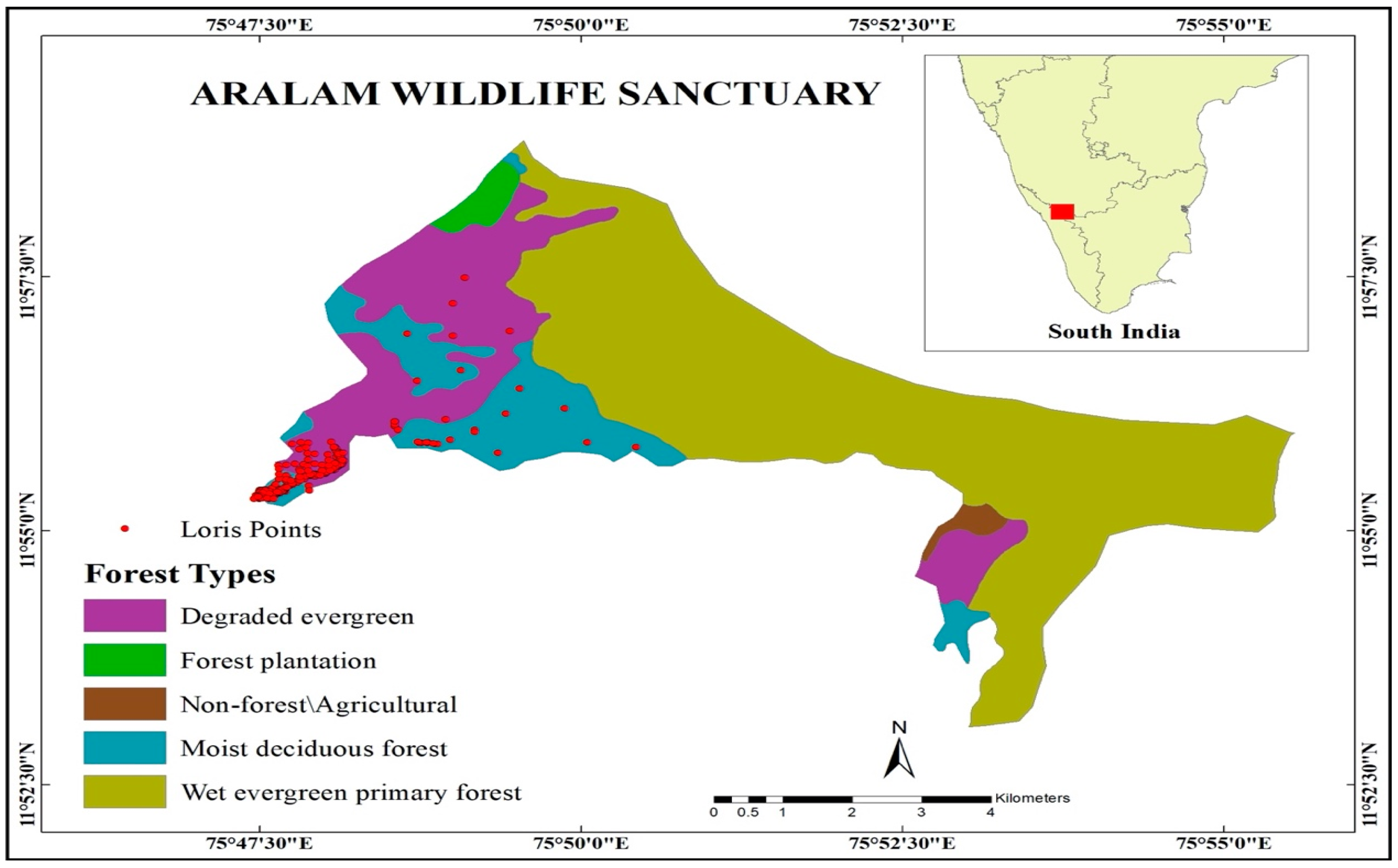
2.1. Study Site

We conducted the present study in the Aralam Wildlife Sanctuary in the south Indian state of Kerala (Figure 1). Spread over 55 km2, the sanctuary is situated on the western slopes of the Western Ghats hills. The site lies between 11°59′ N and 11°54′ N and 75°47′ E and 75°57′ E. The elevation varies from 50 m to 1145 m. The vegetation consists of moist deciduous forest, semi-evergreen forest, evergreen forest, and timber plantations [23,24]. The temperature varies from 21 °C to 40 °C at foothills and 8 °C to 25 °C at high altitudes. The annual rainfall in the region is about 3000 mm [23,24]. A tribal settlement forms a fringe around the study site, with the Aralam Farm on one side and shared boundaries with three townships/human habitation on the other. The Valapattanam River creates a natural boundary line on the side of the township [23,24].

2.2. Data Collection-Loris Surveys

Due to the elusive nature of Malabar slender lorises, estimating their distribution is challenging. Therefore, we analyzed detection data from extensive field surveys to gain insights into their spatial distribution. GPS coordinates of loris detections (“loris points”) were collected based on line transects set up in two different periods [15,23]. A total of 416 loris points were recorded, comprising 337 via line transects from March 2014–March 2016, 69 via line transects from February–March 2017, and 10 from random encounters.
Nocturnal line transect surveys were conducted on foot between 19:30 p.m. and 01:30 a.m. at an average speed of 1 km/h [22,25]. To maximize habitat coverage, sampling trails were laid across varied terrain, including dense foliage and pre-existing animal paths created by deer or elephants. Transects refer to the designated survey lines along which observations were systematically recorded, whereas trails represent the physical paths followed during these surveys. To aid navigation during night surveys, small reflective stickers were placed at regular intervals on trees along both sides of the transects.
Lorises were identified by their distinct orange-red tapetal reflection under dim light (~200 lumens) from Petzl headlamps covered with red cellophane sheets. Upon detection, the sex of each individual was recorded as male, female, or unidentified.
Between March 2014 and March 2016, we employed the first visual contact method [26,27]. Five 2-km transects were surveyed 156 times across diverse habitat types, including degraded evergreen forests, forest plantations, non-forest agricultural land, moist deciduous forests, and wet evergreen forests. Between Februay and March 2017, we set up a 1-ha grid-based occupancy framework, mapped using ArcGIS 9.4 and MapInfo Version 11. Line transects ranging from 63.52 m to 326.94 m in length were marked using handheld GPS units, with a total sampling trail length of 11.41 km.

2.3. Species Distribution Modeling

We used Maxent modeling to predict the current and future potential habitats of the slender loris in our study area. The maximum entropy (MaxEnt) model is a machine learning method with a flexible algorithm that creates species distribution models using presence-only species records [28,29]. The MaxEnt model is proven to better predict habitat suitability in the various species distribution models than other predictive models [30,31]. The advantages of the MaxEnt model for target distribution modeling include firstly the integration of both continuous and categorical variables; and secondly, the output provides the least biased estimation of the target distribution [32]. The model can also deal with the risk of over-fitting by using a regularization parameter that defines the error bound around the average value of observed records and regulates the model to fit the data well [28,33]; available open-source tools such as MaxEnt software 3.4.2. For MAXENT species distribution modeling, all loris points were incorporated. Spatial thinning was applied at 0.5 km to minimize spatial autocorrelation, considering the species’ estimated home range of approximately 1 km2, thereby reducing biases in habitat suitability predictions [34]). A total of 416 direct sightings were spatially thinned using the ‘Wallace’ package [35] in RStudio (version 4.0.2, 22 June 2020) to ensure robust model performance. We had 67 occurrence points for male lorises and 246 occurrence points for female lorises; the rest could not be identified. Spatial thinning reduced the incidence points from 416 to 33.

2.4. Downloading and Preparing Environmental Variable Layers

Changes in environmental factors such as vegetation and atmosphere subtly affect small mammal species in terms of natural necessities and life histories [36]. Therefore, choosing influential predictors based on the ecological relevance of the species improves the accuracy of niche modeling. We used 19 present bioclimatic variables downloaded from the WorldClim database at 30-sec resolution; the future climatic data, CMIP5 at 30-s resolution, was downloaded https://www.worldclim.org/data/worldclim21.html (version 1.4, accessed on 13 April 2020) [37]. The topographic layer, elevation, slope, and aspect were extracted from CartoDEM Version 3-R1 layer with 2.5-s resolution downloaded from the BHUVAN Indian Geo-Platform of ISRO https://bhuvan-app3.nrsc.gov.in/data/download/index.php (accessed on 13 April 2020) using ArcGIS version 10.8 [38]. As lorises are nocturnal and sensitive to white or blue light [39], we considered night light disturbance to be an environmental variable that impacts lorises’ distribution. The night-time light layer was downloaded from the National Centre for Environmental Observation at 500 m (21,600 × 21,600 each tile) resolution (https://ngdc.noaa.gov/eog/viirs/download_dnb_composites.html (accessed on 31 May 2020)). NDVI was downloaded from the BHUVAN Indian Geo-Platform of ISRO (https://bhuvan-app3.nrsc.gov.in/data/download/index.php (accessed on 13 April 2020)). The crop use maps were downloaded from https://croplands.org/app/map?lat=0&lng=0&zoom=2 (accessed on 2 May 2020). We prepared the road layer by marking the trail on a GPS device on the field; the shapefiles of the trails were loaded and processed on ArcGIS version 10.8 [38]. We downloaded the tree cover layer (Treecover2010_20N_070E.tif) from the Global Land Analysis and Discovery (GLAD) [40]. The villages layer was created by marking the borders of the villages on Google Earth Pro (7.3.3.7786) (2020 Google LLC) and then processing it using ArcGIS version 10.8 [38]. We extracted the waterbodies layer using OCM: Surface Waterlayer Products-2 day repetitivity, which was downloaded from the BHUVAN Indian Geo-Platform of ISRO (https://bhuvan-app3.nrsc.gov.in/data/download/index.php (accessed on 2 May 2020)) using ArcGIS version 10.8 [38]. Finally, the cropland layer was downloaded at 30 m resolution (GFSAD30SAAFGIRCE) from NASA (https://www.earthdata.nasa.gov/about/web-unification-project (accessed on 28 April 2020)) [41].
All predictors mentioned in Table 1 were resampled to ~1 km spatial resolution. We filtered layers after performing multicollinearity to create more consistent models and reduce the effects of highly correlated variables [42], because weakly correlated layers can compromise the accuracy of the habitat suitability model [43]. We selected 14 variables as final predictor variables from the above predictors after discarding other variables with a Pearson correlation value greater than 0.75 from the analysis.

2.5. MaxEnt Modeling Analysis

We used MaxEnt version 3.4.1 [28] to produce species distribution and habitat suitability models of the slender loris. The technique uses categorical and continuous environmental data, and we treated all the chosen variables as continuous variables. A logistic output continuous map was selected to obtain the likelihood that the species was present, which permits us to distinguish the suitability of the geographical area under consideration.
The predictor environment variables were selected based on statistical correlation tests. We selected 14 layers with no correlation between the layers. We ran a test run on MaxEnt using 14 layers and estimated the relative contribution of each environment variable to the MaxEnt model. The maximum number of background points used was 10,000. If the change in the absolute value of the lambda was negative during each iteration of the training algorithm, the adjusted gain increase was added or subtracted from the contribution of the corresponding variable to determine the initial estimate. The values of these variables regarding the presence of training and background data were randomly sorted by environment variable in the second estimate. The model was reevaluated using the sorted data, and the reductions in training AUC were normalized by percentage (Table 2).
Studies suggest that further optimization of models may be required when there are small sample sizes. We performed such optimization to find the best variables contributing to the model by stepwise selection of the predictors. In the initial model, we ran the model with the 14 predictors, and in the subsequent models we dropped one predictor each, until we reached two predictors.
Furthermore, we adjusted the present models to the varying regularization multipliers (1, 2 and 5) values, and the complexity of the models was changed by altering MaxEnt features Linear (L), Product (P), Quadratic (Q), Hinge (H) and a combination of these features, viz., LQ, HQ, LQH, LQP, LQT, QHP, QHT, QHPT and AUTO [43]. We used the raw output format for testing the model and ran it for 5000 iterations and 30 replications, including a subsampling procedure. We evaluated the contribution of each bioclimatic variable by using the jackknife protocol [30]. Each of these models was run for each optimization step protocol discussed in the previous paragraph. The selection of models with the best predictors, features and regularization multipliers will reduce the overfitting and underfitting of models with small sample sizes.
We used the program ENMTools 1.4.4 [28,44] to evaluate the models of varying predictors, complexities and regularization multiplier values. We selected the model with the lowest AICc as the most suitable model depicting the present distribution of the slender loris in Aralam Wildlife Sanctuary. AICc values perform better than BIC (Bayesian information criterion) or AUC (area under the curve) values for choosing best models [45,46,47]. After finding the best model, we ran 30 replications of the best model and used the average map for our analysis. The output maps were generated in ArcGIS version 10.8 and clipped onto mask layers [48].

2.6. Future Climatic Projections and Model Evaluations
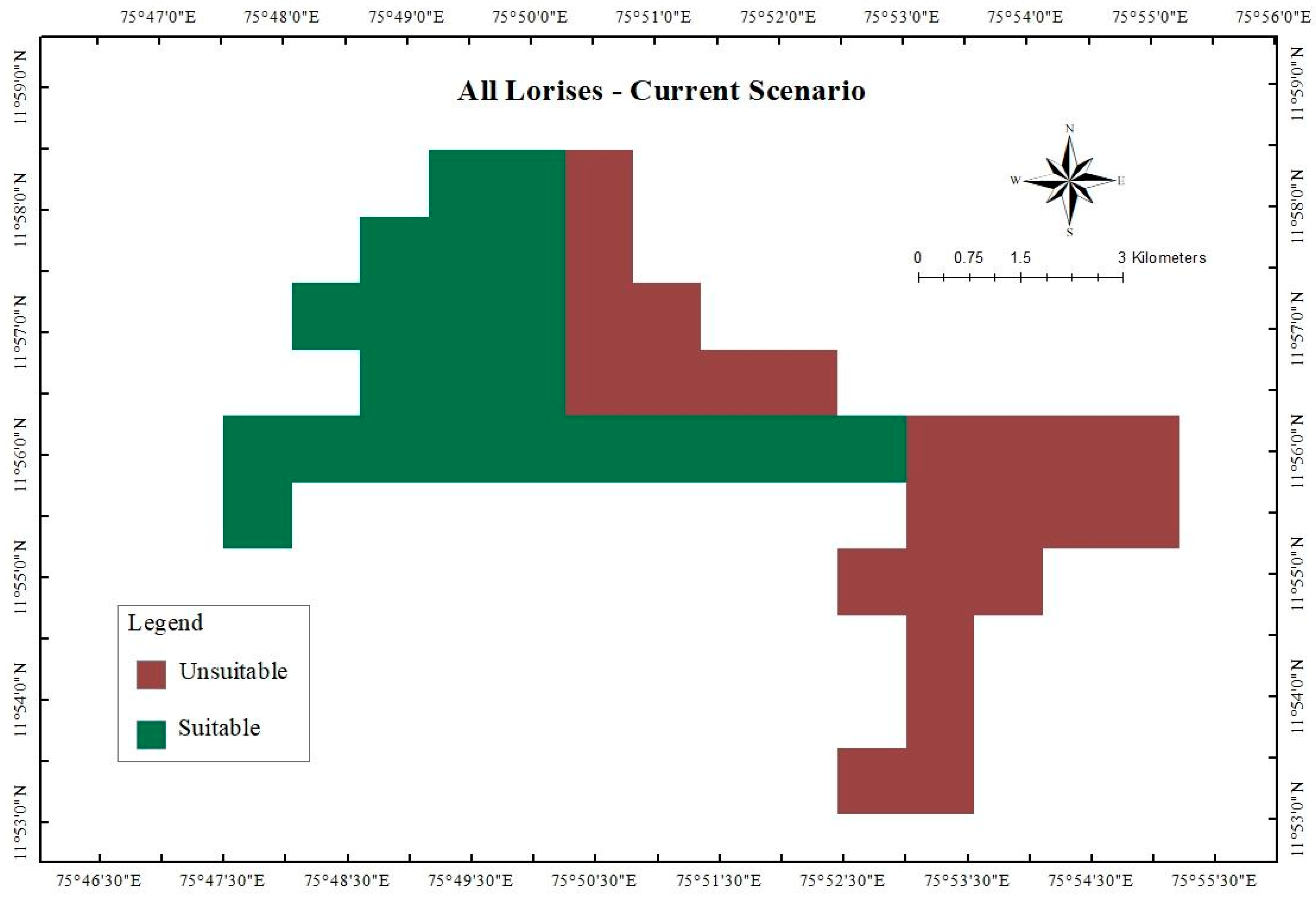
The Representative Concentration Pathway (RCP) is a greenhouse gas concentration trajectory adopted by the IPCC Fifth Assessment Report (AR5) using four pathways for climate modeling [1], which describe different climatic futures. All these pathways are considered possible, depending on the volume of greenhouse gases (GHG) emitted in the years to come. The RCPs—originally RCP 2.6, RCP 4.5, RCP 6, and RCP 8.5—labeled after a possible range of radiative forcing values in the year 2100 [49,50] are consistent with a wide range of possible predicted changes in future anthropogenic greenhouse gas emissions and aim to represent their atmospheric concentrations [51]. The optimistic emission scenario in RCP 2.6 is likely to keep global temperature rise below 2 °C by 2100; RCP 4.5 assumes that greenhouse gas (GHG) emissions peak around 2040 and then stabilize, while in RCP 6.0, the stabilization of GHG emissions occurs after 2060, and in RCP 8.5 the GHG emissions will continue until 2100 [49,50].
We modeled the future climatic projections using the bioclimatic variables for simulating the representative concentration pathways RCP 2.6, RCP 4.5, and RCP 8.5 downloaded from WorldClim (https://worldclim.org/data/v1.4/cmip5.html (accessed on 29 April 2020)) at 30 arc-second (~1 km) spatial resolution. We used CMIP5 data, which are climate projections from global climate models (GCMs) that were downscaled and calibrated (bias-corrected) using WorldClim 1.4 as the baseline climate. For long-term planning and protection of the habitat, we made projections for 2070 (average for 2061–2080). We used bioclimatic projections from the CNRM-CM5 global climate models for our future distribution models. We only considered the effect of climatic factors on the habitat suitability of the slender loris in future scenarios. Using the 10-percentile training of presence logistic threshold value from the MaxEnt output, the map showing the probability of occurrence was reclassified into two potential habitat categories (binary), i.e. regions with loris and regions without loris. We created new layers of overlapping suitable habitat areas. We performed an analysis of the bio18 variable in the future, by subtracting the bio18 layer from 2070 with the bio18 layer of the present to figure out why the most sustainable scenario showed the most decline in the habitat suitability of the loris.

3. Results

The best model based on AICc scores was L1 (feature: linear; regularization multiplier: 1; Predictors: Bio18, road, Bio14, elevation) with AUC training and AUC testing values of 0.71 and 0.67, respectively. The final modeled outputs show that 23 km2 is suitable for the occurrence of lorises (using the 10-percentile training of presence logistic threshold). The output map is shown in Figure 2. There were other models with low AICc, and among them, the two other best models with ΔAICc < 2 was H2 (predictors: all 14 predictors; Bio18, road and Bio14 contributed to more than 99% of the model), and Q1 (predictors: road and Bio14).

3.1. Important Environmental Variables

Of the 14 variables used for modeling (Table 2), only four variables significantly impacted the spatial distribution of lorises. These variables were precipitation of the warmest quarter (Bio 18), followed by distance from the road, precipitation of the driest month (Bio 14), and elevation (Table 3). The permutation importance also showed that Bio 18 had the highest importance. The result from the jackknife test for the environmental variable with the highest gain when used in isolation is Bio18, which therefore appears to have the most useful information by itself.
The environmental variable that decreases the gain the most when omitted is road, indicating that it provides unique information not captured by other variables. The response curves (Figures S1 and S2) show a positive correlation between predicted habitat suitability and Bio14 (precipitation of the driest month) and Bio18 (precipitation of the warmest quarter), while distance from roads negatively influences suitability. These results suggest that Bio18, Bio14, and distance from roads are the key factors shaping the spatial distribution of lorises. Elevation did not play any role in the model.

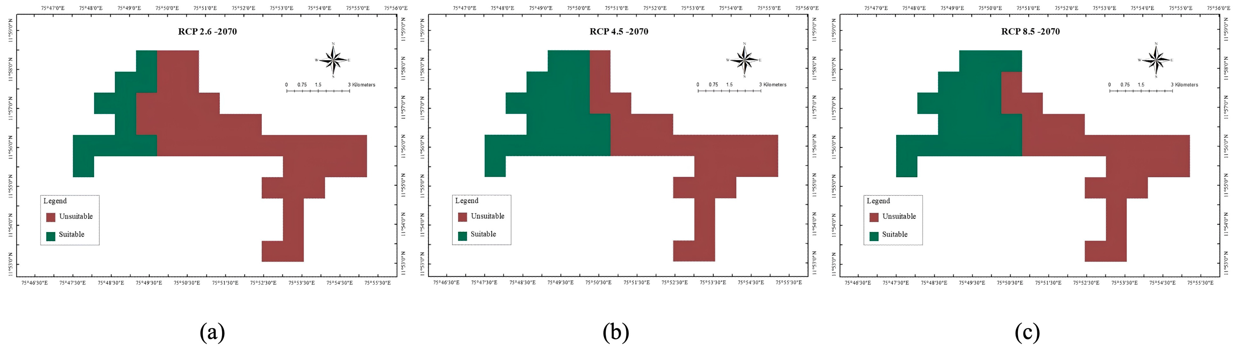
3.2. Projected Shifts in Habitat Suitability Under Future Climate Scenarios

The percentage difference between the current and projected future distribution regions was used to assess potential changes in species distribution. Model projections for the 2070s under RCP 2.6, RCP 4.5, and RCP 8.5 scenarios indicate a significant decline in suitable habitat areas. Among the three scenarios, habitat loss is expected to be most severe under RCP 2.6 (Table 4). Future habitat suitability maps for RCP 2.6, RCP 4.5, and RCP 8.5 are presented in Figure 3.
From Figure 4, we can observe that the precipitation in the warmest quarter was higher in RCP 2.6 in a majority of areas when compared to present precipitation, and the lorises preferred drier areas as seen in RCP 4.5 and RCP 8.5. The RCP 2.6 shows that the majority of the area in Aralam shows similar rainfall to wet evergreen forest in 2070, which lorises do not prefer (Figure 4). Instead they prefer more moist deciduous forest. Figure 1 and Figure 2 show that lorises do not prefer evergreen rain forests. Similarly, in the south-central zone we see that both a severe increase and decrease in precipitation can have a negative impact on the distribution of lorises.

4. Discussion

4.1. The Present Study and Key Findings

Predicting a species’ response to changing climatic conditions on a regional and temporal scale is crucial. Generally, small-bodied mammals are indicators of climatic change and ecological system imbalance [36]. The present study represents the first attempt in India to examine how climate change impacts the Malabar slender loris (Loris lydekkerianus malabaricus) in a small, localized area. Our findings depict the impact of climate change on Malabar slender lorises in Aralam Wildlife Sanctuary, demonstrating that a large portion of habitat space may become unsuitable in the 2070 scenario, endangering the local species’ viability by increasing their extinction risk.
With AUC training and testing scores of 0.71 and 0.67, the study identifies precipitation of warmest quarter (Bio18), distance from roads, and precipitation of driest month (Bio14) as key environmental variables influencing the species’ spatial distribution. Projected habitat suitability under RCP 2.6 scenarios indicates a 52% decline by 2070, demonstrating the urgency for conservation measures [52,53].

4.2. Habitat Preferences and Variations

This preliminary study lays the foundation for expanding research across the species’ entire distribution, as region-specific ecological differences in the Western Ghats could influence the variables affecting slender loris distribution. These climatic and environmental variations align with the species’ preference for moist deciduous, semi-evergreen, and degraded evergreen forests near human habitation [54]. Similar patterns are observed in other arboreal mammals like the lion-tailed macaque (Macaca silenus) and the Nilgiri langur (Semnopithecus johnii), which thrive in moderately disturbed habitats but are negatively impacted by urbanization and deforestation [55,56].
Our results differ from the habitat studies on Loris tardigradus tardigradus and Loris l. nordicus in Sri Lanka, wherein Loris tardigradus tardigradus preferred highly disturbed human habitation or highly disturbed forests [27,57], and Loris lydekkerianus nordicus, being a habitat specialist, was found only in undisturbed montane evergreen forests and mist forests [50] characterized by tall canopies and good connectivity.

4.3. Environmental Drivers and Anthropogenic Impacts

Precipitation of the warmest quarter (Bio18) emerged as a dominant factor, aligning with findings on other species where rainfall influences habitat suitability by impacting vegetation and microhabitats [52]. Due to differences in feeding, habitat, and reproductive requirements, temperature changes may have varying effects on different species [58]. According to Kalle et al. [59], the size of a small mammal’s home range determines its requirements in an ecosystem, with precipitation influencing habitat suitability by affecting food availability, shelter, and movement patterns. Their research on stripe-necked mongooses (Herpestes vitticollis) in Mudumalai, Western Ghats, highlights that rainfall impacts distribution, likely due to its role in shaping resource availability and habitat structure. Bhattacharyya et al. [60], based on observations of Royle’s pika (Ochotona roylei), similarly emphasize that precipitation governs species distribution by influencing burrowing behavior, thermoregulation, and access to forage in high-altitude environments. Depending on neighboring environments and the moisture requirements of certain species, local increases in precipitation may mitigate temperature-driven trends to a greater or lesser extent. Together, temperature and precipitation act as interdependent ecological filters [61].
Proximity to roads significantly impacts various wildlife species, including slender lorises, by exposing them to anthropogenic disturbances such as habitat fragmentation and increased poaching risks. Small and medium-sized mammals often exhibit reduced population densities near roadways due to these disturbances [62,63]. Nocturnal mammals such as the Indian pangolin (Manis crassicaudata) and civets (Viverridae) face heightened risk of poaching because roads facilitate easy human access to previously undisturbed habitats [64].
Although roads pose threats, they can also attract primates, including slender lorises, due to artificial lighting that attracts insects, creating an abundant food source [65]. However, this proximity increases their visibility, making them more vulnerable to poaching, particularly due to superstitious beliefs [66]. A study in Tai National Park, Côte d’Ivoire, by N’Goran et al. [67] found that primate densities decreased near human infrastructure, including roads and villages. However, areas close to research stations and tourism sites had higher monkey densities, suggesting that increased surveillance and law enforcement help deter poaching. These findings emphasize the need for conservation strategies that balance habitat protection and anti-poaching measures, particularly in the Western Ghats, which host endangered species such as the slender loris.
In southern India, slender lorises are frequently targeted for traditional medicine and black magic rituals, where they suffer severe mutilations due to superstitions associating them with supernatural powers [20]. Addressing these threats requires community-level education and awareness programs to dispel harmful myths surrounding the species [20].
Other species, including pangolins, civets, and even larger mammals like leopards (Panthera pardus), are poached for similar reasons in the region [67]. These findings emphasize the urgent need for region-specific conservation strategies tailored to the Western Ghats’ unique ecology.

4.4. Projected Habitat Changes and Broader Implications

The projected decline in habitat under all RCP scenarios, particularly under RCP 2.6, emphasizes the interplay between precipitation, forest types, and species distribution. Increased rainfall in the warmest quarter could shift forest types from moist deciduous to wet evergreen, unsuitable for the loris [68]. Similarly, extreme decrease in rainfall could shift habitats to dry forests, which again might not be suitable for the loris. This trend, compounded by habitat conversion to exotic monocultures, further threatens species reliant on native vegetation [55,56]. Conservation efforts must prioritize habitat restoration, connectivity, and community engagement to mitigate these threats. While lorises can persist in degraded habitats, continuous degradation can lead to complete habitat loss, leaving no suitable environment for their survival.
The findings from this study have broader implications for other species in the Western Ghats, such as the Indian giant squirrel (Ratufa indica) and the Malabar civet (Viverra civettina), which face similar challenges due to climate change and habitat fragmentation [56]. Future studies must expand ecological modeling to encompass these species, enabling integrated conservation strategies across the region.

4.5. Future Directions

This study serves as a critical baseline for understanding the impacts of climate change on slender loris distribution. Future research will expand across its range to explore region-wise ecological variations and refine conservation strategies. Emphasis must be placed on elevational gradients, landscape-level planning, and species-specific interventions, including canopy bridges to improve connectivity [54]. However, such efforts must be balanced with safeguards against poaching through community awareness and involvement [69].
By combining scientific research, community engagement, and adaptive policy measures, this study provides a foundation for safeguarding the biodiversity-rich ecosystems of the Western Ghats. It underscores the need for urgent action to ensure a resilient future for both the slender loris and the broader ecological network it inhabits [70].

5. Conclusions

As an elusive and ecologically sensitive primate, the Malabar slender loris (Loris lydekkerianus malabaricus) plays a crucial role in maintaining the balance of forest ecosystems in the Western Ghats. This study highlights the species’ vulnerability to climatic shifts and habitat degradation, with key environmental variables such as precipitation and distance from the road shaping its spatial distribution. The alarming reduction in habitat suitability projected under future climate scenarios, particularly RCP 2.6, underscores the need for urgent and adaptive conservation measures [71].
The findings from this study also have broader implications for other species in the Western Ghats that share similar ecological niches and face the dual threats of climate change and habitat fragmentation, such as the Indian giant squirrel (Ratufa indica) and the Malabar civet (Viverra civettina) [72]. Future research should focus on holistic approaches, encompassing ecological modeling, landscape-level conservation planning, and region-specific mitigation strategies.
By combining scientific insights, community engagement, and policy interventions, it is possible to safeguard not only the Malabar slender loris but also the biodiversity-rich ecosystems of the Western Ghats. The preservation of these habitats is critical not only for the survival of endemic species but also for the ecological services they provide, ensuring a resilient future for both wildlife and human communities [70].

Supplementary Materials

The following supporting information can be downloaded at: https://www.mdpi.com/article/10.3390/land14040872/s1. Figure S1. Response curves showing relationships between the important environmental variables and probability of the presence of all slender lorises in L1 4 Model. The values shown are an average of fifteen replications of cross-validated MaxEnt models. Figure S2. Jackknife test showing the relative importance of different environmental variables using test gain in L1 4 Model.

Author Contributions

S.D.G. contributed to conceptualization, visualization, supervision, project administration, funding acquisition, investigation, resources, data curation, validation, formal analysis and manuscript writing—original draft preparation. J.J.E. was involved in conceptualization, validation, formal analysis, and Manuscript writing. M.C. contributed to resources and writing—review and editing. M.S. contributed to conceptualization, validation, writing—review and editing and supervision. All authors have read and agreed to the published version of the manuscript.

Funding

Women Scientist Scheme, A (WOS-A) fellowship under the Department of Science and Technology, Government of India, Grant/Award Number: SR/WOSA/LS89/2013, awarded to Smitha D Gnanaolivu.

Institutional Review Board Statement

Our study was noninvasive and followed the Guidelines for Best Practices for Field Primatology of the International Primatological Society. Research protocols were approved by the Principal Chief Conservator of Forests and Chief Wildlife Warden, Forest Headquarters, Vazhuthacaud, Thiruvananthapuram-695014 (Permit No. WL10-17697/2012) and adhered to the legal requirements of the Kerala Forest Department.

Data Availability Statement

The original data presented in the study are openly available in the repository RADAR at https://radar.brookes.ac.uk/radar/items/300b4c97-5c1b-45f5-9414-aeef00e556ee/1/ (accessed on 12 April 2025).

Acknowledgments

This study was conducted under Research Permit No. WL10-17697/2012, issued by the Principal Chief Conservator of Forests and Chief Wildlife Warden, Forest Headquarters, Vazhuthacaud, Thiruvananthapuram–695014. We also thank the Women Scientist Scheme-A (WOS-A) fellowship under the Department of Science and Technology, Government of India (Grant No. SR/WOSA/LS89/2013), for supporting Smitha D. Gnanaolivu during this research. Mewa Singh thanks Indian National Science Academy for the award of Distinguished Professorship during which this article was prepared. We are deeply grateful to the Kerala Forest Department for granting us the necessary permissions and for their cooperation and timely assistance during fieldwork. Special thanks to the officials of the Aralam Wildlife Sanctuary for their invaluable help and support in facilitating our work. Finally, we express our heartfelt thanks to all the villagers and friends who graciously hosted us and supported us in myriad ways during the course of the project. We are also grateful to the members of the Biopsychology Lab for their engaging discussions and valuable feedback on the research findings.

Conflicts of Interest

The authors declare no conflicts of interest.

References

  1. IPCC (Intergovernmental Panel on Climate Change). Synthesis Report. Contribution of Working Groups I, II and III to the Fifth Assessment Report of the Intergovernmental Panel on Climate Change Core Writing Team; Pachauri, R.K., Meyer, L.A., Eds.; Climate Change; IPCC: Geneva, Switzerland, 2014; 151p. [Google Scholar]
  2. Adhikari, D.; Barik, S.K.; Upadhaya, K. Habitat distribution modeling for reintroduction of Ilex khasiana Purk., a critically endangered tree species of northeastern India. Ecol. Eng. 2012, 40, 37–43. [Google Scholar] [CrossRef]
  3. Barnosky, A.D.; Matzke, N.; Tomiya, S.; Wogan, G.O.U.; Swartz, B.; Quental, T.B.; Marshall, C.; McGuire, J.L.; Lindsey, E.L.; Maguire, K.C.; et al. Has the Earth’s sixth mass extinction already arrived? Nature 2011, 471, 51–57. [Google Scholar] [CrossRef] [PubMed]
  4. Worth, J.R.P.; Harrison, P.A.; Williamson, G.J.; Jordan, G.J. Whole range and regional-based ecological niche models predict differing exposure to 21st century climate change in the key cool temperate rainforest tree southern beech (N othofagus cunninghamii). Austral Ecol. 2015, 40, 126–138. [Google Scholar] [CrossRef]
  5. Waller, N.L.; Gynther, I.C.; Freeman, A.B.; Lavery, T.H.; Leung, L.K.-P. The Bramble Cay Melomys Melomys rubicola (Rodentia:Muridae): A first mammalian extinction caused by human-induced climate change? Wildl. Res. 2017, 44, 9–21. [Google Scholar] [CrossRef]
  6. Radchuk, V.; Reed, T.; Teplitsky, C.; van de Pol, M.; Charmantier, A.; Hassall, C.; Adamík, P.; Adriaensen, F.; Ahola, M.P.; Arcese, P.; et al. Adaptive responses of animals to climate change are most likely insufficient. Nat. Commun. 2019, 10, 3109. [Google Scholar] [CrossRef]
  7. Korstjens, A.H.; Hillyer, A. Primates and climate change: A review of current knowledge. In An Introduction to Primate Conservation; Oxford University: Oxford, UK, 2016. [Google Scholar]
  8. Gregory, S.D.; Brook, B.W.; Goossens, B.; Ancrenaz, M.; Alfred, R.; Ambu, L.N.; Fordham, D.A. Long-term field data and climate-habitat models show that orangutan persistence depends on effective forest management and greenhouse gas mitigation. PLoS ONE 2012, 7, e43846. [Google Scholar] [CrossRef]
  9. Tosi, A.J. Forest monkeys and Pleistocene refugia: A phylogeographic window onto the disjunct distribution of the Chlorocebus lhoesti species group. Zool. J. Linn. Soc. 2008, 154, 408–418. [Google Scholar] [CrossRef]
  10. Chandran, M.S.; Rao, G.R.; Gururaja, K.V.; Ramachandra, T.V. Ecology of the swampy relic forests of Kathalekan from central Western Ghats, India. Bioremediat. Biodivers. Bioavailab. 2010, 4, 54–68. [Google Scholar]
  11. Chetana, H.C.; Ganesh, T. Reconciling natural history and species ecology: Myristica beddomei (Myristicaceae) in the Western Ghats, India. Trop. Conserv. Sci. 2013, 6, 663–673. [Google Scholar] [CrossRef]
  12. Priti, H.; Aravind, N.A.; Uma Shaanker, R.U.; Ravikanth, G. Modeling impacts of future climate on the distribution of Myristicaceae species in the Western Ghats, India. Ecol. Engin. 2016, 89, 14–23. [Google Scholar] [CrossRef]
  13. Khanna, B.A. Reduction in Forest Area Has Led to Deficit Rainfall. Deccan Herald Newspaper, 19 August 2016; p. 6. [Google Scholar]
  14. Singh, M.; Singh, M.; Kumara, H.N.; Kumar, S.; Gnanaolivu, S.D.; Sasi, R. A review of research on the distribution, ecology, behaviour, and conservation of the Slender Loris Loris lydekkerianus (Mammalia: Primates: Lorisidae) in India. J. Threat. Taxa 2021, 13, 19540–19552. [Google Scholar] [CrossRef]
  15. Gnanaolivu, S.D.; Kumara, H.N.; Singh, M.; Sudarsanam, D. Ecological determinants of Malabar slender loris (Loris lydekkerianus malabaricus, Cabrera 1908) occupancy and abundance in Aralam Wildlife Sanctuary, Western Ghats, India. Int. J. Primatol. 2020, 41, 511–524. [Google Scholar] [CrossRef]
  16. Groves, C.P. Primate Taxonomy; Smithsonian Institution Press: Washington, DC, USA, 2001. [Google Scholar]
  17. Roonwal, M.L.; Mohnot, S.M. Primates of South Asia: Ecology, Sociobiology and Behavior; Harvard University Press: London, UK, 1977. [Google Scholar]
  18. Schulze, H.; Meier, B. The subspecies of Loris tardigradus and their conservation status: A review. In Creatures of the Dark: The Nocturnal Prosimians; Alterman, L., Doyle, G.A., Izard, M.K., Eds.; Plenum Press: New York, NY, USA, 1995; pp. 193–210. [Google Scholar]
  19. Kumara, H.N.; Nekaris, K.A.I.; Singh, M. Loris lydekkerianus ssp. malabaricus (amended version of 2020 assessment). IUCN Red List. Threat. Species 2022, e.T44720A217744540. [Google Scholar] [CrossRef]
  20. Gnanaolivu, S.D.; Campera, M.; Nekaris, K.A.I.; Nijman, V.; Satish, R.; Babu, S.; Singh, M. Medicine, black magic and supernatural beings: Cultural rituals as a significant threat to slender lorises in India. People Nat. 2022, 4, 734–746. [Google Scholar] [CrossRef]
  21. Nekaris, K.A.I. Social lives of adult Mysore slender lorises (Loris lydekkerianus lydekkerianus). Am. J. Primatol. 2006, 68, 1171–1182. [Google Scholar] [CrossRef]
  22. Sasi, R.; Kumara, H.N. Distribution and relative abundance of the slender loris Loris lydekkerianus in Southern Kerala, India. Prim. Conserv. 2014, 28, 165–170. [Google Scholar] [CrossRef]
  23. Gnanaolivu, S.D.; Singh, M.; Sudarsanam, D. Habitat structure and use of the Malabar slender loris (Loris lydekkerianus malabaricus, Cabrera 1908) in the Western Ghats, India. Department of Advanced Zoology and Biotechnology, Loyola College, University of Madras, Chennai, India, 2020, in preparation.
  24. Menon, A.R.R. Vegetation Mapping and Analysis of Aralam Wildlife Sanctuary Using Remote Sensing Techniques. KFRI Res. Rep. 1999, 168. Available online: https://docs.kfri.res.in/xxxxKFRI-RR/KFRI-RR168.pdf (accessed on 12 April 2025).
  25. Sterling, E.J.; Ramaroson, M.G. Rapid assessment of the primate fauna of the eastern slopes of the Réserve Naturelle Intégrale d’Andringitra, Madagascar. Fieldiana Zool. 1996, 85, 293–305. [Google Scholar]
  26. Charles-Dominique, P.; Bearder, S.K. Field studies of lorisoid behaviour: Methodological aspects. In The Study of Prosimian Behaviour; Doyle, G.A., Martin, R.D., Eds.; Academic Press: New York, NY, USA, 1979; pp. 567–629. [Google Scholar]
  27. Gamage, S.; Liyanage, W.; Weerakoon, D.; Gunwardena, A. Habitat quality and availability of the Sri Lanka red slender loris Loris tardigradus tardigradus (Mammalia: Primates: Lorisidae) in the Kottawa Arboretum. J. Threat. Taxa 2009, 1, 65–71. [Google Scholar] [CrossRef]
  28. Phillips, S.B.; Aneja, V.P.; Kang, D.; Arya, S.P. Modeling and analysis of the atmospheric nitrogen deposition in North Carolina. Int. J. Glob. Environ. Issues 2006, 6, 231–252. [Google Scholar] [CrossRef]
  29. Phillips, S.J.; Dudík, M.; Schapire, R.E. A maximum entropy approach to species distribution modeling. In Proceedings of the 21st International Conference on Machine Learning, Banff, AB, Canada, 4–8 July 2004; p. 83. [Google Scholar] [CrossRef]
  30. Elith, J.; Graham, H.C.; Dudík, M.; Ferrier, S.; Guisan, A.; Ferrier, S.; Huettmann, F.R.; Leathwick, J.; Lehmann, A.; Li, J.; et al. Novel methods improve prediction of species’ distributions from occurrence data. Ecography 2006, 29, 129–151. [Google Scholar] [CrossRef]
  31. Hernandez, P.A.; Graham, C.H.; Master, L.L.; Albert, D.L. The effect of sample size and species characteristics on performance of different species distribution modeling methods. Ecography 2006, 29, 773–785. [Google Scholar] [CrossRef]
  32. Jaynes, E.T. Information theory and statistical mechanics. Phys. Rev. 1957, 106, 620–630. [Google Scholar] [CrossRef]
  33. Phillips, S.J.; Dudík, M. Modeling of species distributions with Maxent: New extensions and a comprehensive evaluation. Ecography 2008, 31, 161–175. [Google Scholar] [CrossRef]
  34. Steen, V.A.; Tingley, M.W.; Paton, P.W.C.; Elphick, C.S. Spatial thinning and class balancing: Key choices lead to variation in the performance of species distribution models with citizen science data. Methods Ecol. Evol. 2021, 12, 216–226. [Google Scholar] [CrossRef]
  35. Kass, J.M.; Vilela, B.; Aiello-Lammens, M.E.; Muscarella, R.; Merow, C.; Anderson, R.P. Wallace: A flexible platform for reproducible modeling of species niches and distributions built for community expansion. Methods Ecol. Evol. 2018, 9, 1151–1156. [Google Scholar] [CrossRef]
  36. Rowe, R.J.; Terry, R.C. Small mammal responses to environmental change: Integrating past and present dynamics. J. Mammal. 2014, 95, 1157–1174. [Google Scholar] [CrossRef]
  37. Fick, S.E.; Hijmans, R.J. WorldClim 2: New 1-km spatial resolution climate surfaces for global land areas. Int. J. Climatol. 2017, 37, 4302–4315. [Google Scholar] [CrossRef]
  38. Esri. ArcGIS Desktop: Release 10.8; Environmental Systems Research Institute: Redlands, CA, USA, 2020. [Google Scholar]
  39. Fuller, G.; Raghanti, M.A.; Dennis, P.M.; Kuhar, C.W.; Willis, M.A.; Schook, M.W.; Lukas, K.E. A comparison of nocturnal primate behavior in exhibits illuminated with red and blue light. Appl. Anim. Behav. Sci. 2016, 184, 126–134. [Google Scholar] [CrossRef]
  40. Potapov, P.; Li, X.; Hernandez-Serna, A.; Tyukavina, A.; Hansen, M.C.; Kommareddy, A.; Pickens, A.; Turubanova, S.; Tang, H.; Silva, C.E.; et al. Mapping and monitoring global forest canopy height through integration of GEDI and Landsat data. Remote Sens. Environ. 2020, 253, 112165. [Google Scholar] [CrossRef]
  41. Gumma, M.K.; Mohammad, I.; Nedumaran, S.; Whitbread, A.; Lagerkvist, C.J. Urban sprawl and adverse impacts on agricultural land: A case study on Hyderabad, India. Remote Sens. 2017, 9, 1136. [Google Scholar] [CrossRef]
  42. De Bin, R.; Janitza, S.; Sauerbrei, W.; Boulesteix, A.L. Subsampling versus bootstrapping in resampling-based model selection for multivariable regression. Biometrics 2016, 72, 272–280. [Google Scholar] [CrossRef] [PubMed]
  43. Veloz, S.D. Spatially auto correlated sampling falsely inflates measures of accuracy for presence-only niche models. J. Biogeogr. 2009, 36, 2290–2299. [Google Scholar] [CrossRef]
  44. Warren, D.L.; Glor, R.E.; Turelli, M. Environmental niche equivalency versus conservatism: Quantitative approaches to niche evolution. Evolution 2008, 62, 2868–2883. [Google Scholar] [CrossRef]
  45. Morales, N.S.; Fernández, I.C.; Baca-González, V. MaxEnt’s parameter configuration and small samples: Are we paying attention to recommendations? A systematic review. PeerJ 2017, 5, e3093. [Google Scholar] [CrossRef]
  46. Warren, D.L.; Seifert, S.N. Ecological niche modeling in Maxent: The importance of model complexity and the performance of model selection criteria. Ecol. Appl. 2011, 21, 335–342. [Google Scholar] [CrossRef]
  47. Wordley, C.F.R.; Sankaran, M.; Mudappa, D.; Altringham, J.D. Landscape scale habitat suitability modeling of bats in the Western Ghats of India: Bats like something in their tea. Biol. Conserv. 2015, 191, 529–536. [Google Scholar] [CrossRef]
  48. Reineking, B. Constrain to perform: Regularization of habitat models. Ecol. Model. 2006, 193, 675–690. [Google Scholar] [CrossRef]
  49. Moss, R.H.; Edmonds, J.A.; Hibbard, K.A.; Manning, M.R.; Rose, S.K.; Van Vuuren, D.P.; Carter, T.R.; Emori, S.; Kainuma, M.; Kram, T.; et al. The next generation of scenarios for climate change research and assessment. Nature 2010, 463, 747–756. [Google Scholar] [CrossRef]
  50. Sharma, J.; Upgupta, S.; Jayaraman, M.; Chaturvedi, R.K.; Bala, G.; Ravindranath, N.H. Vulnerability of forests in India: A national scale assessment. Environ. Manag. 2017, 60, 544–553. [Google Scholar] [CrossRef] [PubMed]
  51. Collins, M.; Knutti, R.; Arblaster, J.; Dufresne, J.-L.; Fichefet, T.; Friedlingstein, P.; Gao, X.; Gutowski, W.J.; Johns, T.; Krinner, G.; et al. Long-term Climate Change: Projections, Commitments and Irreversibility. In Climate Change 2013—The Physical Science Basis: Contribution of Working Group I to the Fifth Assessment Report of the Intergovernmental Panel on Climate Change; Stocker, T.F., Qin, D., Plattner, G.-K., Tignor, M.M.B., Allen, S.K., Boschung, J., Nauels, A., Xia, Y., Bex, V., Midgley, P.M., Eds.; Cambridge University Press: Cambridge, UK, 2013; pp. 1029–1136. [Google Scholar]
  52. Beaumont, L.J.; Hughes, L.; Poulsen, M. Predicting species distributions: Use of climatic parameters in BIOCLIM and its impact on predictions of species’ current and future distributions. Ecol. Model. 2007, 200, 347–359. [Google Scholar] [CrossRef]
  53. Kumar, S.; Stohlgren, T.J. MaxEnt modeling for predicting suitable habitat for threatened and endangered tree canopies of the US Great Plains. J. Ecol. Nat. Environ. 2009, 1, 94–98. [Google Scholar]
  54. Kumara, H.N.; Singh, M.; Kumar, S. Distribution, habitat correlates and conservation of slender loris (Loris lydekkerianus) in Karnataka, India. Int. J. Primatol. 2006, 27, 941–969. [Google Scholar] [CrossRef]
  55. Sukumar, R.; Suresh, H.S.; Ramesh, R. Climate change and its impact on tropical forest ecosystems in southern India. J. Biogeogr. 1995, 22, 533–544. [Google Scholar] [CrossRef]
  56. Sukumar, R.; Suresh, H.S.; Dattaraja, H.S. Monoculture plantations and their impact on biodiversity in the Western Ghats. Ambio 1998, 27, 579–585. [Google Scholar]
  57. Nekaris, K.A.I.; Stevens, N.J. All lorises are not slow: Rapid arboreal locomotion in the newly recognised red slender loris (Loris tardigradus tardigradus) of southwestern Sri Lanka. Am. J. Phys. Anthropol. 2005, 40, 156. [Google Scholar]
  58. Sherwin, H.A.; Montgomery, W.I.; Lundy, M.G. The impact and implications of climate change for bats. Mammal Rev. 2013, 43, 171–182. [Google Scholar] [CrossRef]
  59. Kalle, R.; Ramesh, T.; Qureshi, Q.; Sankar, K. Predicting the distribution pattern of small carnivores in response to environmental factors in the Western Ghats. PLoS ONE 2013, 8, e79295. [Google Scholar] [CrossRef]
  60. Bhattacharyya, S.; Mungi, N.A.; Kawamichi, T.; Rawat, G.S.; Adhikari, B.S.; Wilkening, J.L. Insights from present distribution of an alpine mammal Royle’s pika (Ochotona roylei) to predict future climate change impacts in the Himalaya. Reg. Environ. Change 2019, 19, 2423–2435. [Google Scholar] [CrossRef]
  61. Thibault, K.M.; Ernest, S.K.M.; White, E.P.; Brown, J.H.; Goheen, J.R. Long-term insights into the influence of precipitation on community dynamics in desert rodents. J. Mammal. 2010, 91, 787–797. [Google Scholar] [CrossRef]
  62. Goosem, M. Fragmentation impacts caused by roads through rainforests. Curr. Sci. 2007, 93, 1587–1595. [Google Scholar]
  63. Benítez-López, A.; Alkemade, R.; Verweij, P.A. The impacts of roads and other infrastructure on mammal and bird populations: A meta-analysis. Biol. Conserv. 2010, 143, 1307–1316. [Google Scholar] [CrossRef]
  64. Laurance, W.F.; Goosem, M.; Laurance, S.G. Impacts of roads and linear clearings on tropical forests. Trends Ecol. Evol. 2009, 24, 659–669. [Google Scholar] [CrossRef]
  65. Rich, C.; Longcore, T. Ecological Consequences of Artificial Night Lighting; Island Press: Washington, DC, USA, 2006. [Google Scholar]
  66. N’Goran, P.K.; Boesch, C.; Mundry, R.; N’Goran, E.K.; Herbinger, I.; Yapi, F.A.; Kuhl, H.S. Hunting, law enforcement, and African primate conservation. Conserv. Biol. 2012, 26, 565–571. [Google Scholar] [CrossRef]
  67. Rathore, A.; Bhatnagar, Y.V. Threats to wildlife in India: A review of illegal trade and poaching practices. Environ. Conserv. 2019, 46, 345–357. [Google Scholar]
  68. Williams, J.W.; Jackson, S.T.; Kutzbach, J.E. Projected distributions of novel and disappearing climates by 2100 AD. Proc. Nat. Acad. Sci. USA 2003, 104, 5738–5742. [Google Scholar] [CrossRef]
  69. Das, J.; De Silva, A. Conservation of Sri Lankan lorises: A review of conservation priorities. Prim. Conserv. 2005, 20, 67–72. [Google Scholar]
  70. Chavan, V.; Rane, S.; Patwardhan, A. Climate resilience strategies for the Western Ghats biodiversity hotspot. Environ. Res. Commun. 2020, 2, 045001. [Google Scholar]
  71. IPCC (Intergovernmental Panel on Climate Change). Climate Change 2021: The Physical Science Basis. In Contribution of Working Group I to the Sixth Assessment Report of the Intergovernmental Panel on Climate Change; IPCC: Geneva, Switzerland, 2021. [Google Scholar]
  72. Menon, V. Indian Mammals: A Field Guide; Hachette India: Delhi, India, 2020. [Google Scholar]
Figure 1. Map of Aralam Wildlife Sanctuary showing the points where slender lorises were detected (“loris points”).
Land 14 00872 g001
Figure 2. Habitat suitability predictions using MaxEnt for slender lorises under the current climatic conditions, vegetation, and topographic features.
Land 14 00872 g002
Figure 3. Predicted future habitat suitability of Malabar slender loris in 2070 under climatic scenarios (a) RCP 2.6, (b) RCP 4.5, (c) RCP 8.5.
Land 14 00872 g003
Figure 4. The layer obtained by subtracting the Bio18 layer of the present from the Bio18 layer of the future (a) RCP 2.6 (b) RCP 4.5 (c) RCP 8.5.
Land 14 00872 g004
Table 1. List of variables prepared for the MaxEnt Modeling.
Serial NumberVariablesDescription
1Bio1Annual mean temperature
2Bio2Mean diurnal range (mean of monthly (max temp − min temp))
3Bio3Isothermality (BIO2/BIO7) (×100)
4Bio4Temperature seasonality (standard deviation ×100)
5Bio5Max temperature of warmest month
6Bio6Min temperature of coldest month
7Bio7Temperature annual range (BIO5-BIO6)
8Bio8Mean temperature of wettest quarter
9Bio9Mean temperature of driest quarter
10Bio10Mean temperature of warmest quarter
11Bio11Mean temperature of coldest quarter
12Bio12Annual precipitation
13Bio13Precipitation of wettest month
14Bio14Precipitation of driest month
15Bio15Precipitation seasonality (coefficient of variation)
16Bio16Precipitation of wettest quarter
17Bio17Precipitation of driest quarter
18Bio18Precipitation of warmest quarter
19Bio19Precipitation of coldest quarter
20ASPECTDerived continuous layer from DEM. Calculated as compass direction of the downslope direction using spatial analyst extension of ArcGIS 10.8
21SLOPEDerived continuous layer from DEM. Calculated as degrees using spatial analyst extension of ArcGIS 10.8
22ELEVATIONDigital elevation model (DEM) generated from stereo images of Indian remote sensing satellite Cartosat-1 with 30 m resolution
23ROADDistance from road; derived continuous layer created by calculating Euclidean distance from road using ArcGIS 10.8
24LANDUSEDistance from croplands; derived continuous layer created by calculating Euclidean distance from road using ArcGIS 10.8
25TREECOVERLayer showing the treecover of the different forest areas
26LIGHTNocturnal light disturbance
27VILLAGESDistance from villages; derived continuous layer created by calculating Euclidean distance from villages using ArcGIS 10.8
28WATERBODIESDistance from waterbodies; derived continuous layer created by calculating Euclidean distance from waterbodies using ArcGIS 10.8
29NDVINormalized Difference Vegetation Index, derived from remote sensing data, measuring vegetation greenness and density. It is calculated as (NIR − Red)/(NIR + Red), where NIR (near-infrared) and Red refer to spectral reflectance values. NDVI helps assess habitat quality and vegetation cover dynamics.
Table 2. Environment variables used for modeling.
Serial NumberVariables
1Road
2Bio 18
3Bio 14
4Elevation
5Aspect
6Waterbodies
7Landuse
8Light
9NDVI
10Bio 7
11Slope
12Treecover
13Bio 15
14Villages
Table 3. Environmental variables used to model L1 4 and its percent contribution and permutation importance.
VariableDescriptionPercent ContributionPermutation Importance
Bio 18Precipitation of warmest quarter59.662.6
RoadDistance from road29.437.4
Bio 14Precipitation of driest month10.90
ElevationDigital elevation model (DEM)00
Table 4. Area (km2) showing suitable habitats under current and three future climatic scenarios.
Suitable Habitat (in km2)
Habitat SuitabilityBaselineRCP 2.6RCP 4.5RCP 8.5
Current Time (present)23
2070 11 (−52.17%)20 (−13.04%)21 (−8.69%)
Disclaimer/Publisher’s Note: The statements, opinions and data contained in all publications are solely those of the individual author(s) and contributor(s) and not of MDPI and/or the editor(s). MDPI and/or the editor(s) disclaim responsibility for any injury to people or property resulting from any ideas, methods, instructions or products referred to in the content.

