Article

Geotourism Based on Geoheritage as a Basis for the Sustainable Development of the Golija Nature Park, Southwest Serbia

by
Aleksandar S. Petrović
*,
Ivana Carević
,
Dušica Trnavac Bogdanović
,
Marko Langović
,
Natalija Batoćanin
and
Jovan Petronijević
Geography Faculty, University of Belgrade, Studentski trg 3/III, 11000 Belgrade, Serbia
*
Author to whom correspondence should be addressed.
Land 2025, 14(4), 835; https://doi.org/10.3390/land14040835
Submission received: 27 February 2025 / Revised: 2 April 2025 / Accepted: 9 April 2025 / Published: 11 April 2025
(This article belongs to the Special Issue Geoparks as a Form of Tourism Space Management II)

Abstract

:
Golija Mountain, located in the southwestern part of Serbia, has been under protection as the Golija Nature Park since 2001. It is protected to preserve its forest ecosystems, diverse landscapes of exceptional beauty, and cultural heritage. Due to its natural and cultural values, the Golija Nature Park was declared a UNESCO Biosphere Reserve under the name “Golija-Studenica” in the same year. In addition to its ecosystem values, due to the complex geological and geomorphological past, there are a significant number of geodiversity objects on the mountains in the park. Research on these geodiversity objects has been the focus of the park’s administration in recent years. This protected natural area faces several challenges, with the sustainable development of tourism being one of the most significant. The construction of a large ski center is planned, which has already triggered the spontaneous development of unregulated weekend settlements near the mountain’s highest peaks. Geotourism provides an alternative to this development. Geosites, as the most representative landscapes and landforms, serve as key attractions for geotourists. The main goal of this work was to find appropriate geoactivities related to geosites that will enhance the geotourism offer, all with the aim of achieving the sustainable development of the Golija Nature Park.

1. Introduction

Geotourism is a form of tourism that sustains or enhances the geographical characteristics of a place—its environment, culture, aesthetics, heritage, and the well-being of its local communities. It aligns with the principles of sustainable tourism, ensuring that destinations remain unspoiled for future generations as well as with ecotourism, emphasizing that tourism revenue should support conservation efforts [1]. Geotourism is a knowledge-based form of tourism that integrates the tourism industry with the conservation and interpretation of abiotic natural features within geosites for the general public [2]. In the hierarchy of geotourism interest, landscapes and landforms are the most significant [3]. Their scientific and aesthetic value fosters sustainable economic development by providing opportunities for outdoor recreation and the appreciation of nature [4,5,6].
Geotourism has been increasingly discussed in Serbia over the past decade, driven by both global interest in the field and extensive research on geodiversity and geoheritage, which began in the early 21st century [7,8]. Geotourism research has been most prominent in Eastern Serbia [9,10,11,12,13,14,15,16], particularly within Đerdap National Park [17,18,19,20], following its designation as a UNESCO Global Geopark by the UNESCO General Conference in 2020. In contrast, Western Serbia has been less represented in previous studies. Research has primarily focused on popular tourist destinations such as Tara National Park [20] and Zlatibor Mountain [21], with one study also addressing Golija Mountain [22]. Across all these studies, geoheritage sites have played a significant role in shaping geotourism development [1].
Geoheritage can be represented through geosites—natural locations where geodiversity elements occur in situ—or through museum collections, where ex situ specimens are preserved outside their natural context. As the concept of geoheritage has evolved, new elements, such as hydrological heritage, have been introduced [23]. Earlier geoheritage research on Golija Mountain (Republic of Serbia) focused on geological objects of geoheritage, which included structural, sedimentological, and paleontological sites [24]. This paper examines the geomorphological and hydrological geoheritage of the Golija Nature Park through the study of geosites. In recent years, extensive field research [25,26] has been conducted, leading to the discovery of previously undocumented geomorphological and hydrological features of geoheritage. Numerous indicators have been analyzed to assess the current state of these features and their potential for geotourism development. The findings from this research provide a foundation for further studies in geotourism.
Geosites, as the most representative landscapes and landforms, serve as key attractions for geotourists. The primary objective of this study was to identify the most significant geoheritage sites (geosites) and determine suitable geoactivities associated with them to enhance the geotourism experience. Connecting these geosites with the cultural heritage of the park, particularly the Studenica Monastery, a UNESCO World Heritage site, would significantly increase visitor interest and engagement. Additionally, improving the geotourism offer will contribute to the sustainable development of the Golija Nature Park.

2. Study Area

The southwestern region of Serbia, encompassing the Golija, Radočelo, and Čemerno mountains (Figure 1), was designated as a nature park in 2001 by the Government of the Republic of Serbia [27] as a protected area of exceptional importance. This designation also includes the Studenica and Gradac Monasteries. In the same year, the UNESCO Man and the Biosphere program (MAB) recognized a large portion of this nature park as the “Golija-Studenica” Biosphere Reserve.
The Golija Nature Park spans approximately 75,000 hectares, which includes 57,000 hectares that make up the Biosphere Reserve. The park’s mountains belong to the Dinaric Mountain system, with Golija being the most extensive, reaching its highest peak at Jankov Kamen (1834 m).
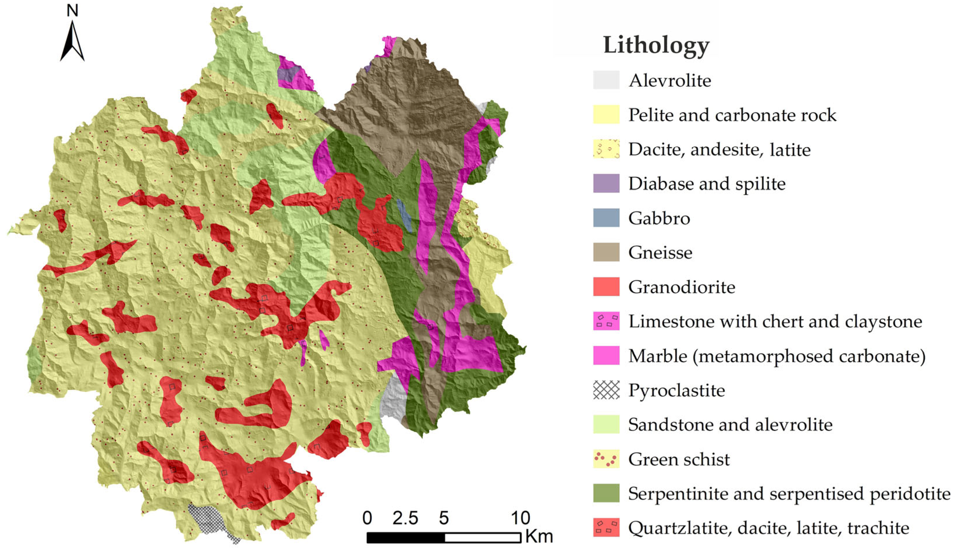
The complex geological structure of the mountains within the Golija Nature Park is the result of intense magmatic activity in the geological past (Figure 2). The oldest rocks in the park are Paleozoic metamorphic formations, primarily green schists, gneisses, marble, and metamorphosed carbonates [28,29]. During the Mesozoic era, sedimentary processes led to the formation of sandstones, alevrolites, and pelites. The massive and dolomitic limestones along the park’s eastern rim date back to the Triassic period.
At the onset of the Quaternary, the region experienced significant tectonic activity, accompanied by magmatism. This magmatic activity resulted in serpentinization and hydrothermal alteration. The volcanic rocks in the area include quartz latites, dacites, latites, and trachytes, often associated with pyroclastic material (Figure 2). Plutonic formations are predominantly composed of granodiorites [28,29].
Due to its geological composition, the Golija Nature Park is rich in high-quality watercourses [30,31] and contains more than 100 natural springs [32]. The main factors contributing to the preservation of water quality and the broader environment include the area’s relative isolation, the limited economic development in most settlements, significant depopulation, and the socio-economic conditions of the local population [33].
Figure 2. Lithology map of the Golija Nature Park (modified on the basis of the geological maps of Serbia 1:100,000 [34,35,36,37]).
Land 14 00835 g002
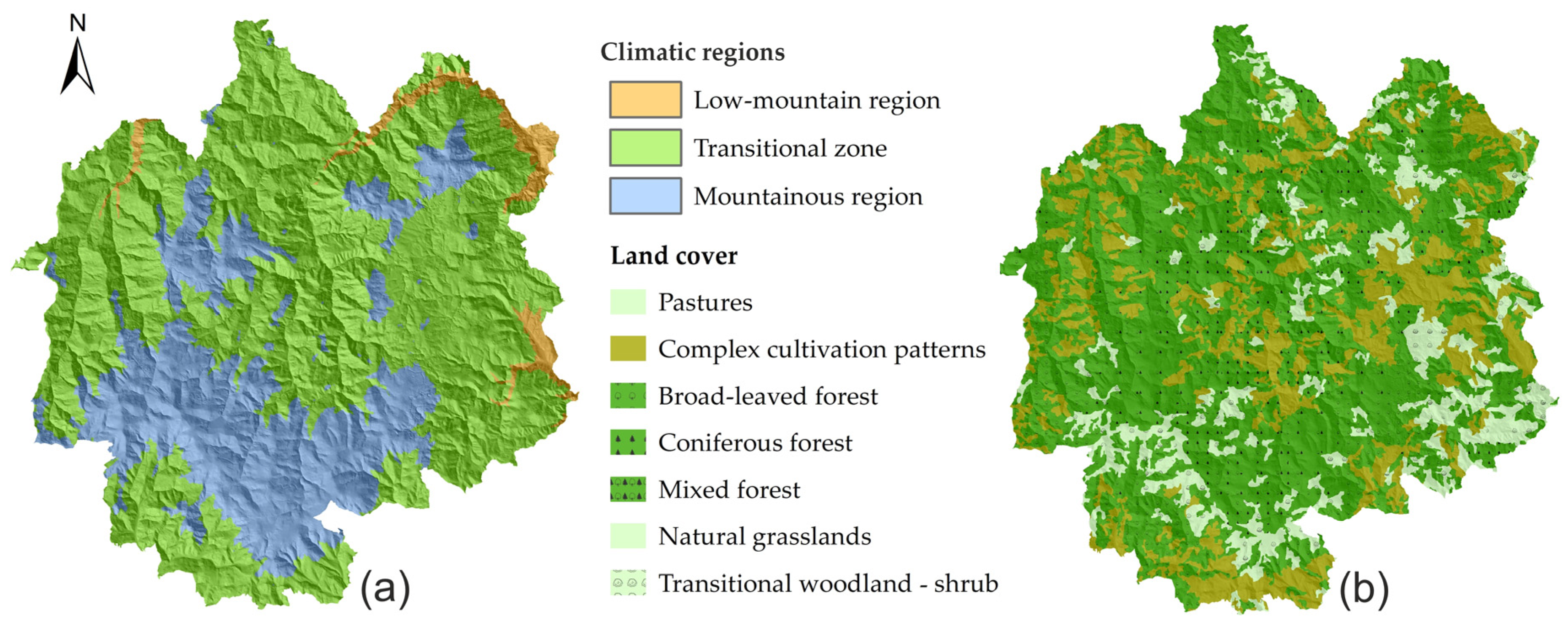
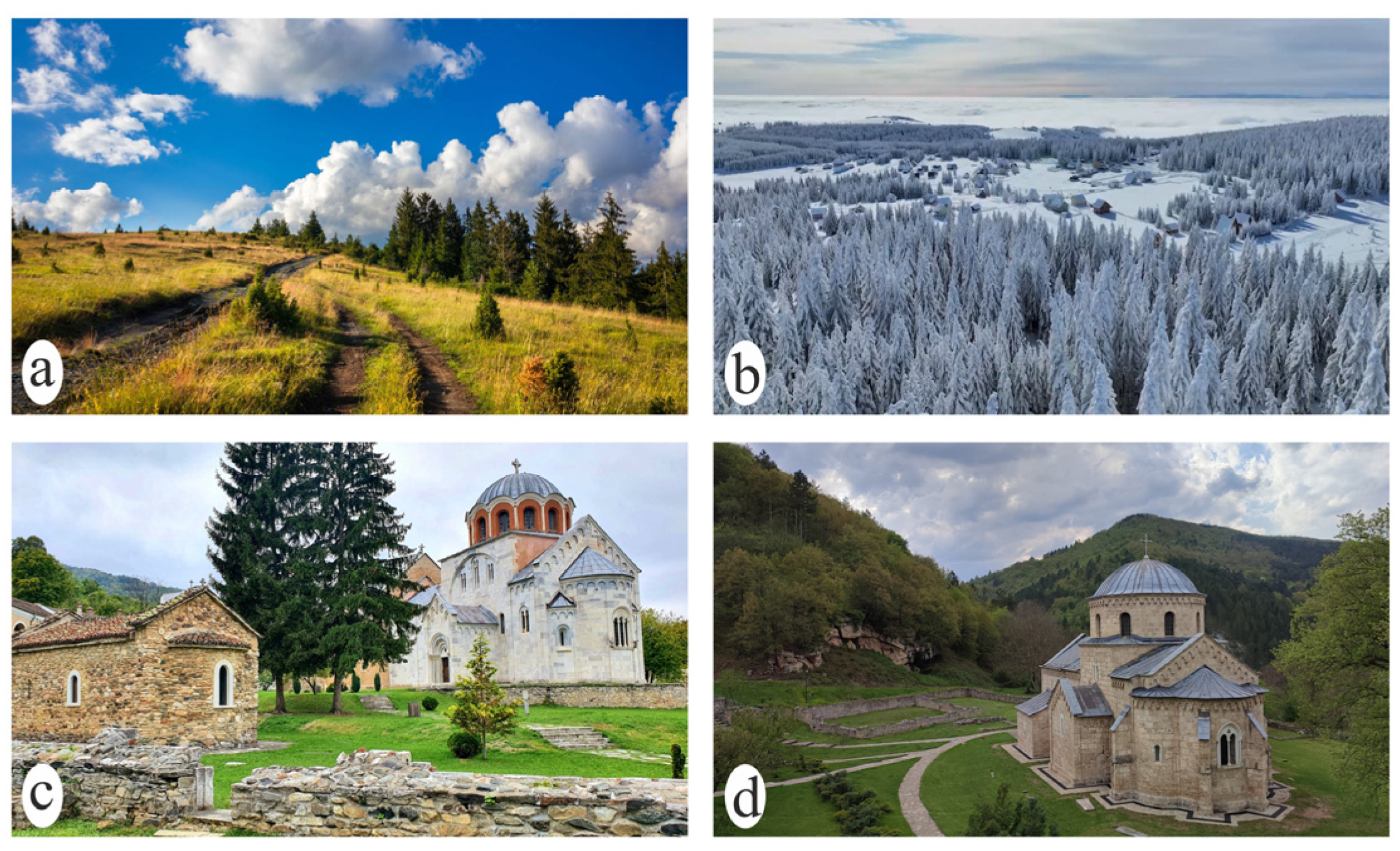
The Golija Nature Park is divided into three climatic regions based on altitude: the low-mountain region (up to 700 m a.s.l.), the transitional zone (up to 1300 m a.s.l.), and the mountainous region (above 1300 m a.s.l.). The mountainous zone (Figure 3a) is characterized by long winters and short, cool summers. On average, the snow cover on Golija Mtn. (Figure 4b) lasts for about two months [38].
Figure 3. Climatic regions (a) and land cover (b) of the Golija Nature Park (modified on the basis of CORINE Land Cover 100 m vector [39]).
Land 14 00835 g003
The cultural and historical heritage of this region is significant, with several notable structures. Foremost among them is the Studenica Monastery (Figure 4c), recognized as a UNESCO World Heritage Site [40] in 1986 for its architectural, artistic, and spiritual value. Additionally, the Gradac Monastery (Figure 4d) and the hermitage of St. Sava (both the lower and upper sections) are protected by the Republic of Serbia.
In addition to its significant biological and cultural heritage, the Golija Nature Park is home to numerous geoheritage sites. Some of these have already been evaluated and included in the Inventory of Serbian Geoheritage Sites [7]. Others are currently the focus of ongoing geoheritage research within the park, which has been intensively conducted in recent years [25,26,41]. It is anticipated that some of the studied sites will be added to the National Inventory of Geoheritage Sites.
The Golija Nature Park is one of the most forested areas in Serbia, boasting an exceptionally rich forest cover (Figure 3b), with some sections remaining completely untouched [32]. The landscape is a mosaic of diverse ecosystems, primarily forests and meadows (Figure 4a). Additionally, the park features significant aquatic ecosystems, including mountain lakes and bogs.

3. Materials and Methods

During the assessment of the karst geomorphosites in Kučaj and Beljanica [14], a modified methodology, originally developed for the assessment of geomorphosites in Montesinho National Park [42], was applied. A similar approach was used in this study. The assessment process consisted of two stages: inventory and quantification, with each employing a specific methodology. The results were then analyzed and used to develop proposals for geotourism development in the Golija Nature Park.
The inventory phase involved identifying the geodiversity of the Golija Nature Park and selecting geosites through a qualitative assessment. This identification was based on a literature analysis, field research, and a GIS analysis. The findings from previous research [24,41] provided the foundation for field studies conducted within the nature park [25,26]. All the identified geodiversity features were incorporated into the Geomorphological Information System (GmIS), developed by following the methodology previously used by Petrović et al. [14]. In addition to standard layers such as lithology, tectonics, geomorphology, and hydrology, GmIS was further enhanced with new data layers related to anthropogenic structures, including settlements, roads, and tourist infrastructure, to support further analyses.
The qualitative assessment was conducted by a geodiversity expert using a modified survey previously applied in the Tauzer region and the Kučaj and Beljanica Mountains [14,43]. The survey was adapted to the requirements of methods for the assessment of geosites, so in addition to the original ones, questions related to the relationship of the locality with the surrounding infrastructure (existence, quality, and distance of the locality from it) were added. A special part was related to the relationship between the locality and the tourist offer in the surrounding area. The primary goal of this assessment was to select geodiversity features with significant scientific value that could be classified as geoheritage sites within the Golija Nature Park. The questionnaire covered the description, genetic classification, utilization, and conservation status of the identified features. A secondary objective was to gather the necessary data for the subsequent quantitative assessment phase.
For the quantification stage, the Geosite Assessment Model (GAM) method was applied [44]. This method evaluates geosites based on their main values (MVs) and additional values (AVs). The main values consisted of three indicator groups: scientific/educational (VSE), scenic/aesthetic (VSA), and protection (VPr). The VSE value was calculated as the sum of the following sub-indicators: rarity, representativeness, geosite research, and level of interpretation. The VSA value was determined by the following sub-indicators: the number of viewpoints in the vicinity, the geosite’s area, the surrounding landscape, and its integration within the landscape. The protection (VPr) value reflects the current state and level of geosite protection, its sensitivity to changes or damage, and its corresponding visitor capacity [44].
The additional values include two groups: functional (VFn) and touristic (VTr). The functional (VFn) value takes into account additional natural and anthropogenic values, the proximity of emissive centers, the accessibility of major road networks, and other functional factors. Although not directly related to the geosite itself, this indicator is crucial for assessing its potential for tourism development.
The tourism (VTr) value assesses the current state of (geo)tourism services and facilities. It consists of the following sub-indicators: promotional activities, the number of organized visits, the proximity to visitor centers, the presence of interpretive boards, the number of visitors, tourist infrastructure, guide services, and the availability of accommodation and catering services [44].
Each group contains a set number of sub-indicators, 12 for MVs and 15 for AVs. These sub-indicators are graded on a scale from 0 to 1 based on predefined tabular criteria [44]. By summing the values of the sub-indicators, separate scores for MVs and AVs are obtained. These scores are then used to create a matrix of main and additional values. The matrix, divided into nine zones, determines the geosite classification, clearly indicating its level of significance.
The geosite assessment was conducted by experts involved in the Golija Nature Park geoheritage inventory projects, with participation from park administration members and mountain tour guides.
In order to understand the place of geotourism based on geoheritage in the tourist offer of the Golija Nature Park, an analysis of all the spatial, protection, and tourism planning documents related to this special purpose area was carried out.

4. Results

During the inventory stage, the foundation for field research was based on earlier expert studies of specific landforms in Golija [45,46,47,48,49]. Additionally, previous research and efforts to protect the geoheritage of this area played a crucial role in the analysis [24,41,50].
As part of the first research phase, field surveys on the geodiversity of the Golija Nature Park were conducted in 2022 [25,26]. A questionnaire was completed, and a qualitative assessment was performed on a large number of investigated sites. This assessment identified thirteen key geosites that represent the most significant geoheritage features of the Golija Nature Park. Three of these geosites consist of multiple landforms (Košaninova Lakes, Izubra Waterfalls, and lakes near Stevovac). Three geosites are already recognized as official geoheritage sites of the Republic of Serbia [50].
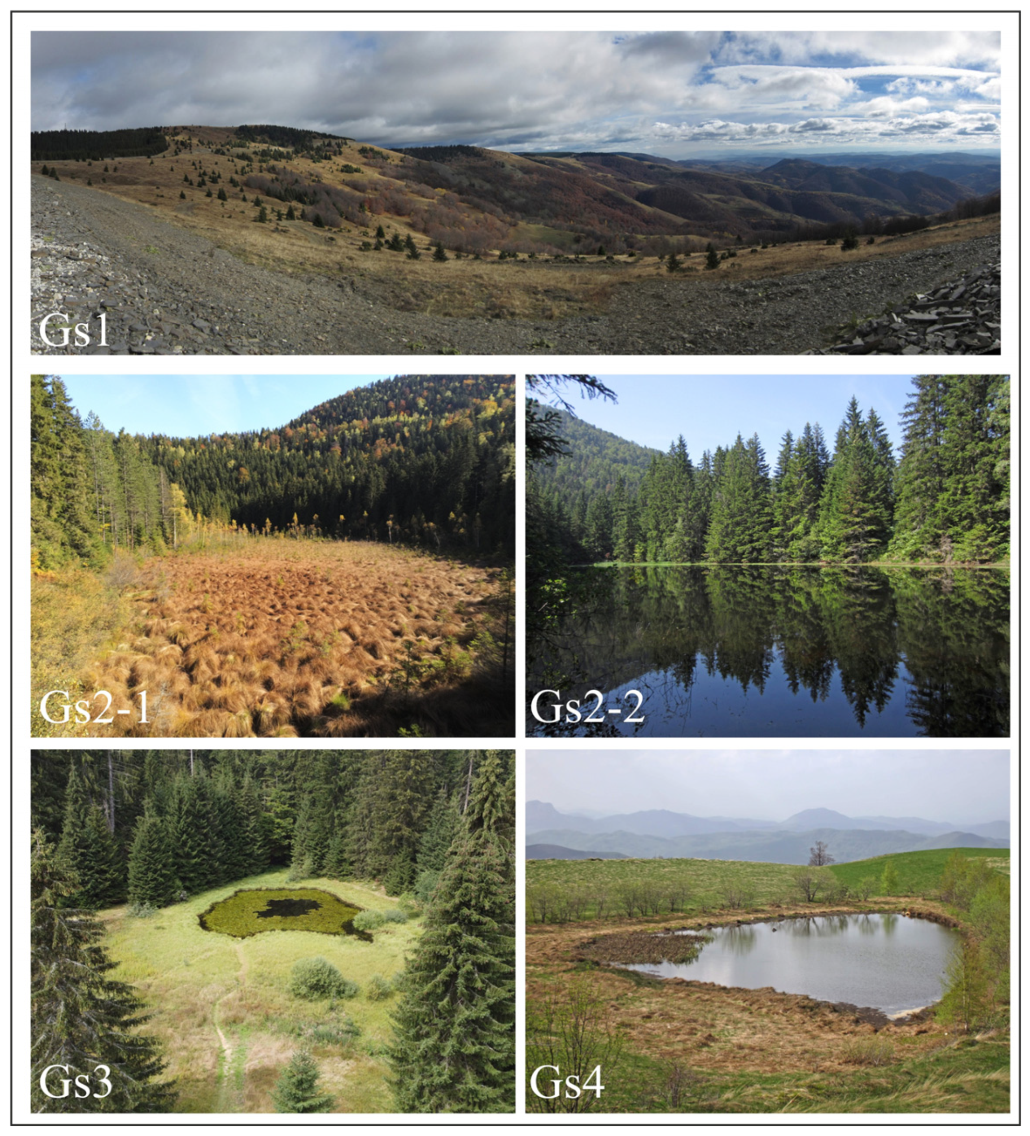
Cirque Jankov Kamen (Figure 5(Gs1)) is a glacio-nivational landform [46,48] located near, but not directly beneath, Golija’s highest peak, Jankov Kamen (1834 m a.s.l.). It is protected in the Serbian Geoheritage Inventory as a glacial feature [50]. Recent studies suggest that this site contains three smaller, distinct glacio-nivation cirques formed over multiple evolutionary phases [41], making them a unique geomorphological entity within Golija.
Another significant group of geosites represents the geomorphological–hydrological geoheritage of Golija Mountain [26]. The Košanin Lakes, consisting of Large Lake (Figure 5(Gs2-1)) and Small Lake (Figure 5(Gs2-2)), are listed in the Geoheritage Inventory and protected as geomorphological geoheritage sites, specifically as bogs. Large Lake is distinguished by its unique wetland vegetation, which enhances its distinct natural ambiance. In contrast, Small Lake experiences significant seasonal fluctuations in water levels, occasionally drying up completely [26].
Dajić Lake (Figure 3(Gs3)), another geosite from the inventory, is also a protected wetland. Surrounded by diverse vegetation, it forms an integral part of the park’s natural landscape. Both Košanin Lakes and Dajić Jezero are located within the park’s first-level protection zone.
Additionally, two other locations with similar characteristics merit inclusion in the Golija Geoheritage Inventory. Okruglica Lake (Figure 5(Gs4)), formed in a shallow depression on a cryo-nivation terrace [40], is a rare example of such a landform in Serbia. Lakes near Stevovac (Gs13), consisting of an upper and lower lake, share a similar origin with Dajić Lake.
The next group of geoheritage sites consists of waterfalls. Given Golija Mountain’s well-developed hydrographic network, the area contains a considerable number of waterfalls. Two geosites stand out due to their formation processes and aesthetic appeal.
The Savošnica River Waterfall (Figure 6(Gs5)) is located at its confluence with the Studenica River. It represents a unique morphological–hydrological phenomenon known as a “hanging river mouth” [41].
The Izubra Waterfalls (Figure 6(Gs6)) form a distinct natural entity on Golija Mountain. This geosite consists of two series of waterfalls, the Upper and Lower Izubra Falls, with a total of four waterfalls in each series. The tallest waterfall in this system reaches a height of 8 m [26].
Another unique geosite on Golija Mountain is the rock pillar Vranji Krš (Figure 6(Gs7)). This site is located within an active fault zone with right- and left-lateral shear movements [40]. In addition to its geomorphological significance, the geosite serves as an excellent natural viewpoint, further enhancing its value.
A distinct group of geosites consists of speleological geoheritage objects [25]. Karst landforms in the Golija Nature Park are primarily found along its eastern edge, forming a meridional belt with a variable width, reaching a maximum of 4 km (averaging around 800 m). In addition to this karst strip, several small karst oases exist, where unique karst formations have developed.
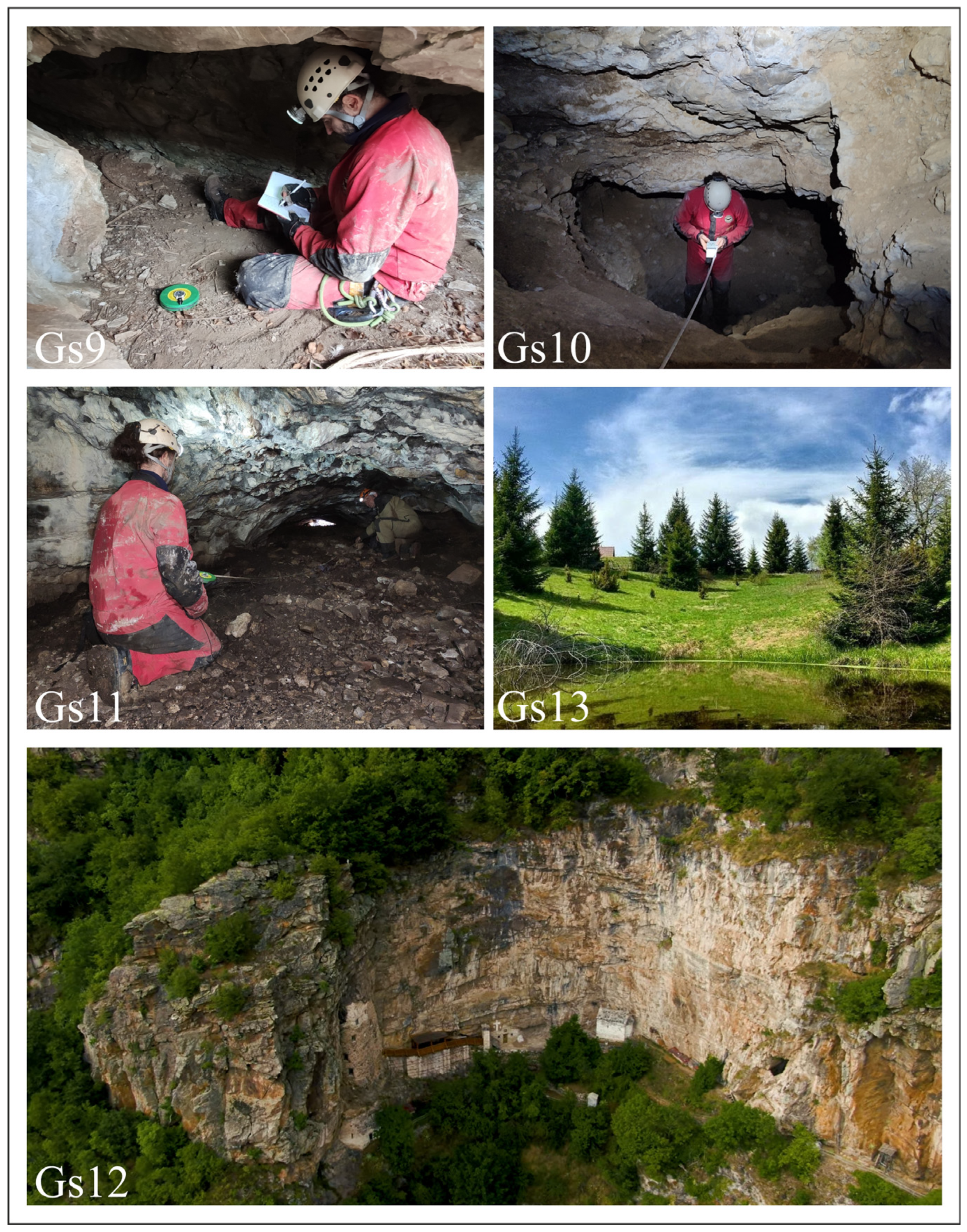
The cave in Tlačina (Figure 7(Gs11)) is the only one formed in classic carbonate rocks, specifically Triassic massive and banked limestones [28,29]. The cave in Strmac (Figure 7(Gs9)) and the rock shelter at Upper Hermitage of St. Sava (Figure 7(Gs12)) were formed in metamorphosed carbonates [25]. Meanwhile, the cave in Tenjkovo (Figure 7(Gs10)) was created in organic sandstones with a CaCO3 binder. The cave in Petrov Krš Hill (Figure 6(Gs8)) is unique, having formed within a fossil tufa deposit, making it the only one of its kind in this region.
The caves in the Golija Nature Park are relatively small in size, with the longest measuring 270 m and the shortest just 12.5 m. However, beyond their speleological significance and intriguing landform characteristics, their morphology and location provide additional value. The caves in Tlačina and Tenjkovo form small labyrinths that are accessible to most adventurous visitors. The cave in Strmac, positioned within a steep section, can only be reached using mountaineering techniques. The cave in Petrov Krš Hill and the overhang near the Upper Hermitage of St. Sava are part of a complex of exceptionally significant and protected cultural heritage in Serbia.
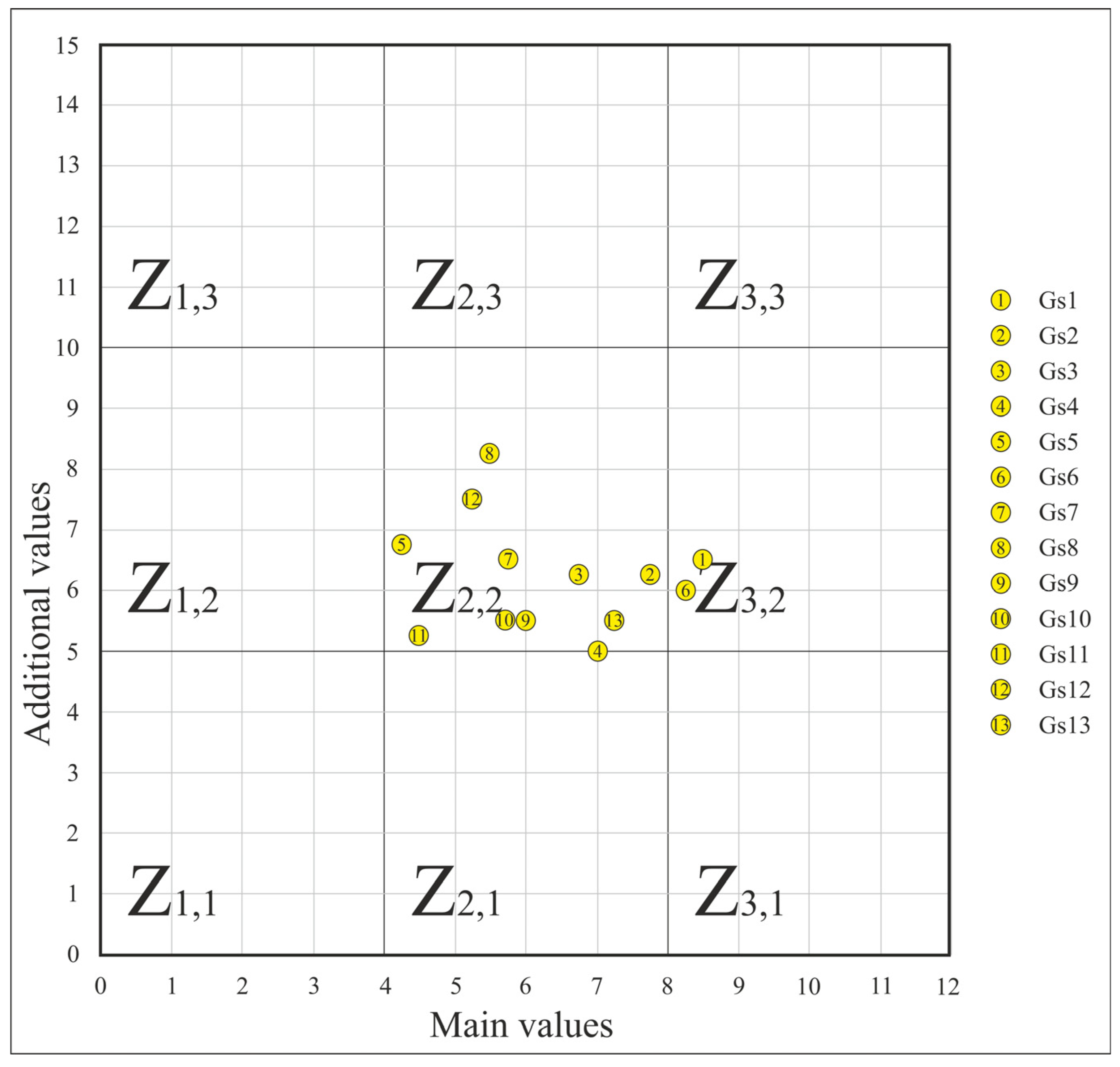
Following the inventory stage, the quantification stage was conducted using the GAM method. The summarized analysis results are presented in Table 1. These results indicate that, among the main values, the VPr sub-indicators exhibited the most uniform values. This consistency was primarily due to the high level of protection across the entire area. Minor variations in the values depended on the specific protection zone in which a geosite was located, as well as its proximity to cultural heritage sites protected at the national and global levels.
The VSE value considers the rarity, representativeness, research, and level of interpretation of a site. Although the most representative geodiversity features were analyzed, the VSE value was lower than expected. This was primarily due to the lack of comprehensive research and the inadequate presentation of previous findings. The most significant variations occurred in the VSA value, influenced by the geosite’s location and its relationship with the surrounding environment. However, considering that the Golija Nature Park has experienced minimal anthropogenic pressure in recent decades, it has largely retained its natural appearance, resulting in relatively high VSA values.
The additional values of the analyzed geosites did not show significant differences among them. This can be attributed to two main factors. First, the location of the nature park highlights its isolation from major tourist emission centers and its distance from key road networks, with the exception of the regional road to Montenegro in the Ibar River valley. The depopulation of this remote mountain area has led to a lack of additional functional amenities, such as gas stations, parking facilities, and car services. Second, the existing tourist facilities in the nature park are favorably distributed in relation to the evaluated geosites, which has partially improved the VTr values.
The results of this analysis are also presented in the GAM matrix (Figure 8). The matrix clearly shows that the vast majority of the geosites fell within the category of moderate main and additional values. This positioning in the evaluation matrix highlights opportunities for improvement at each individual geosite, as well as potential strategies for their enhancement. Only two geosites stood out with distinct primary values: the Jankov Kamen cirque (Gs1), recognized as a unique landform of its type, and the Izubra Waterfalls (Gs6), a complex of multiple waterfalls located in close proximity to one another.
Two geosites, classified as part of protected cultural heritage, exhibited slightly higher additional values. These included the cave in Petrov Krš Hill (Gs8), situated near the medieval Gradac Monastery, and the cave near the Hermitage of St. Sava (Gs12).
An analysis of strategic documents [51,52,53,54] revealed a significant divergence in perspectives between planners and experts [22,55,56]. However, both groups agreed that respecting national and international conservation regulations is essential for the sustainable development of tourism. The key directions for development should focus on three main aspects: active Golija (summer and winter activities), rural–traditional Golija, and the protected natural beauty of Golija [54].
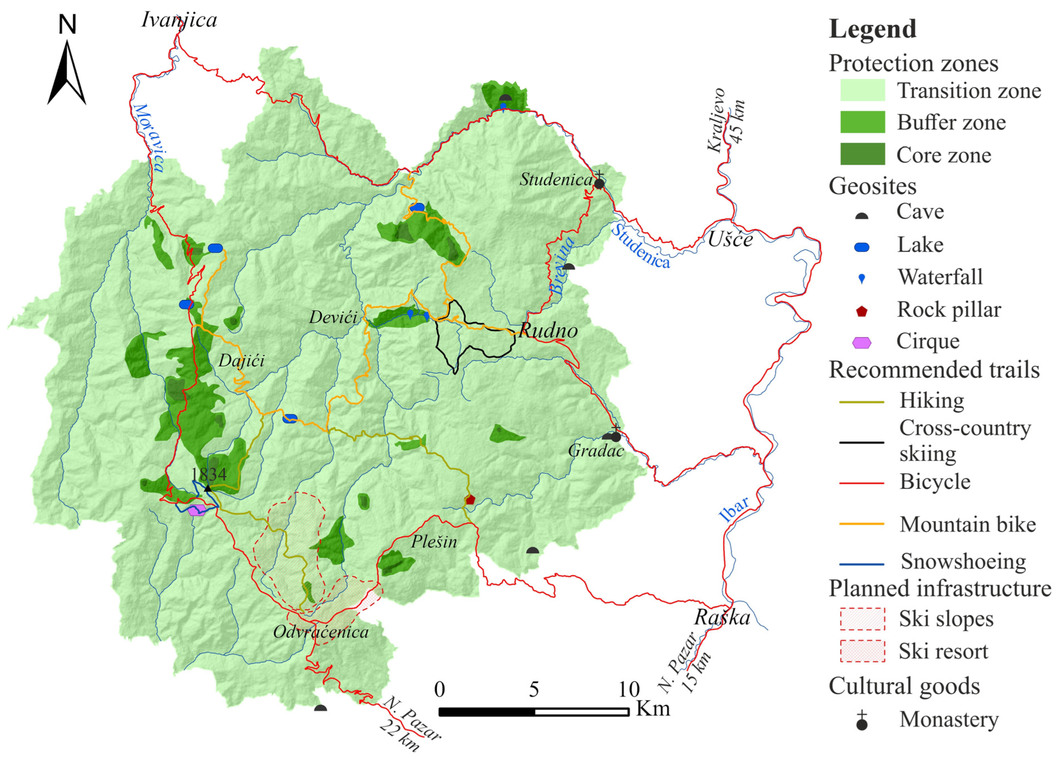
A major point of contention lies in the concept of active Golija and the planned capacity for such activities. Experts [22,55] advocate for the development of ecotourism, wellness tourism, rural tourism, religious tourism, and sightseeing and excursion tourism, as well as recreational activities such as cycling, hiking, horseback riding, and paragliding. While these forms of tourism are acknowledged in planning documents [53,54], the primary focus has been placed on the development of a ski center. This project envisions a ski resort at Odvraćenica and another in the Vrhovi area (Figure 9), with a planned capacity of 25,000 beds and accommodations for 17,000 simultaneous skiers [54].
Experts believe that constructing a tourist center in the highest zone of the Golija Nature Park would significantly harm the natural environment and jeopardize its protected status, particularly its UNESCO MAB designation [55]. Similar negative impacts, including deforestation and unregulated (“wild”) construction, have already been observed in Serbia’s largest ski resort, located within Kopaonik National Park [57].

5. Discussion

Given that detailed research on the geodiversity and geoheritage of Golija Mt. is relatively recent, it is understandable that earlier planning documents and tourism studies do not explicitly mention its potential for enhancing the region’s tourism offerings. However, the results of the GAM assessment suggest that most geosites in Golija Mt. have a strong foundation that can be further improved.
This improvement could take two main directions: first, through the continued scientific evaluation of each geosite, and second, by enhancing their value through infrastructure investments. Considering the priority tourism development strategies outlined in planning documents—along with planned improvements to the road network and bicycle and pedestrian paths, and the creation of additional viewpoints—there is a clear opportunity to integrate geotourism based on geoheritage into the future development of the entire protected area.
Establishing a geopark, as a tool for sustainable development, would be a good solution for the current problems of the nature park. A geopark is a nationally protected area that contains a number of geoheritage sites of particular importance, rarity, or aesthetic appeal [58]. Bearing in mind the geopark’s integrated concept of protection, education, and sustainable development, geotourism and geoparks together can serve as valuable tools for rural development, particularly in peripheral areas experiencing depopulation [59]. However, the Golija Nature Park is not currently included in the national list of potential geoparks [60]. The closest considered territory for a geopark is Uvac, which would border Golija to the west. This presents an opportunity to integrate these two protected areas into future planning documents, aligning with the existing conservation framework of the park.
The first step in utilizing geoheritage objects for geotourism is their identification and protection [61]. A well-informed approach to protection is essential for developing a sustainable geotourism offering. This development depends on factors such as the geosite’s capacity, its susceptibility to degradation from human activities, the infrastructure requirements (e.g., caves), and other considerations.
Research on geotourism products [62,63,64] has identified three key aspects: the form aspect (landscape, landforms, etc.), the process aspect (tectonic activities, weathering, erosion, etc.), and the tourist aspect (attractions, activities, accommodations, trips, interpretation, management, etc.). By adhering to the protection norms of the Golija Nature Park geosite and considering all three aspects of geotourism, it is possible to design geoactivities that effectively showcase its geoheritage.
Among all geoactivities, hiking has the longest tradition in Golija Mtn. The mountain features approximately fifty peaks exceeding 1000 m above sea level, with nineteen rising above 1500 m. Despite the presence of numerous marked hiking trails, the mountain remains relatively unexplored by hikers. This is primarily due to the limited availability of accommodations in mountain lodges, with only two active lodges and several inactive ones. Another key factor is the insufficient promotion of Golija Mtn. as an authentic “wild” destination.
In the future, well-marked hiking trails that integrate the mountain’s natural beauty—forests, meadows, and geosites—could greatly enhance its tourism appeal. These trails should connect rural tourism hubs (e.g., Figure 9), simultaneously expanding the accommodation options and fostering the sustainable development of local communities.
Educational tourism on Golija Mountain is currently primarily associated with cultural tourism. The main destinations for student excursions are the monasteries on the outskirts of the Golija region, such as Studenica and Gradac. However, educational tourism encompasses not only excursions for elementary and high school students [65], but also academic activities conducted on-site [66]. Integrating Golija’s geoheritage into educational tourism would significantly enhance its appeal and broaden the range of learning opportunities available.
The presentation of geoheritage holds significant educational potential [14,67]. Beyond the intrinsic appeal of geosites, accessibility from major road routes and the availability of accommodation facilities play a crucial role in attracting this type of tourist. Excursions for primary and secondary school students require either substantial accommodation facilities or proximity to main roads. Therefore, the most suitable geosites for educational tourism in the Golija Nature Park are those near the Studenica and Gradac Monasteries.
University field trips, being less logistically demanding, can be organized in connection with local tourist centers such as Rudno, Odvraćenica, Raška, and Ivanjica. Additionally, all geosites on the mountain are well suited for scientific field trips. The Izubra Waterfalls, the lakes on Golija Mountain, and the Jankov Kamen cirque (Figure 1 and Figure 9) are excellent examples of geosites with significant potential for such field trips.
Key improvements needed for the development of educational tourism include better infrastructure—such as parking areas, visitor centers, and well-maintained trails—as well as enhanced promotional efforts, including informational boards, printed materials, online resources, and mobile applications.
The exploration of the speleological geodiversity of the Golija Nature Park is relatively recent [25], which explains the current absence of speleotourism offerings. However, two speleological geosites are located within protected cultural landmarks—the Gradac Monastery and the upper hermitage of St. Sava (Figure 9). Despite their small size, these geosites play a significant role in promoting geoheritage and are, in a sense, the most frequently visited geosites on the mountain.
In recent years, speleological geoheritage and geotourism have gained increasing attention from the scientific community, particularly in relation to their sustainable development [13,68,69,70,71,72,73]. Given the morphological characteristics of the caves on Golija Mountain, they do not fit the traditional concept of show caves. However, three caves present excellent opportunities for adventure-based speleotourism [74].
The caves in Tenjkovo and Tlacina are well suited for small groups of adventure tourists (up to 10 people) accompanied by a professional guide. A tourism package could include personal protective equipment and lighting. The caves’ low technical difficulty and intriguing mazes make them particularly appealing for school-aged children, enhancing the attractiveness of these geosites.
The cave in Strmac is situated on the steep, 350 m high right valley wall of the Brevina River Gorge. This rocky section is ideal for establishing a climbing route [75] that would pass by the cave. Additionally, it could be equipped as a “via ferrata”, making the cave accessible to adventure tourists and enhancing the geotourism offerings.
In the mid-to-late 20th century, the Golija Nature Park had a well-developed road network, primarily consisting of ground and macadam roads. Asphalt roads were built toward the end of the last century and the beginning of the 21st century. However, due to village depopulation and reduced human activity in the area, many roads have become overgrown with vegetation. Despite this, a significant portion of these roads remains in use.
Given the growing interest in promoting cycling as a sustainable method for developing rural areas with tourism potential [76], these roads present an excellent opportunity for establishing a network of mountain biking trails. This approach would greatly enhance accessibility to the mountain’s geosites. A prime example is the potential “Golija Lakes” route (Figure 9), which has untapped tourist potential [77]. Mountain bikers could take advantage of the many offerings of Golija’s rural tourism infrastructure. Additionally, the increasing popularity of e-bike trails [78] should be considered, as they make mountain biking more accessible to a wider range of users by reducing physical effort.
While the asphalt road network remains limited, its current state is well suited for developing cycling tourism focused on geoheritage. Many geosites are located directly along or near these roads (Figure 9). A circular route through the Golija Nature Park, covering most of the geosites and passing beneath the mountain’s peak, spans approximately 160 km. This would serve as an ideal option for cycling holidays [76].
All the geoactivities mentioned so far are primarily associated with the summer tourist season. A common feature among them is that they require minimal infrastructural development on the mountain. In contrast, winter tourism has traditionally been linked to alpine skiing, which, until recently, was considered synonymous with mountain tourism in our country. Golija has a small ski resort at Odvraćenica. However, rather than developing a large-scale ski center, due to previously discussed constraints, there are winter activities that can be connected to geoheritage, such as snowshoeing and cross-country skiing.
Both activities are still in their early stages on Golija Mtn. Several snowshoeing guides [79] are actively promoting this experience (Figure 10). Accommodations are provided by hotels and cottages along roads that are maintained during winter. The ideal geosites for these activities include areas near Odvraćenica and Rudno, as well as locations along the main road, such as the Janko’s Stone cirque (Figure 9). Additionally, the Izubra Waterfalls, which often freeze in winter, serve as a unique attraction for tourists who reach them via snowshoeing or cross-country skiing.
Unlike snowshoeing, which requires minimal equipment, cross-country skiing currently lacks proper infrastructure on the mountain. At present, it is mainly practiced by adventurers, but developing and equipping trails could make it accessible to a broader range of tourists.

6. Conclusions

Part of the Golija Nature Park is protected by UNESCO MAB due to its rich biodiversity and significant cultural heritage. In exploring the geodiversity of Golija Mountain, a list of geoheritage sites was compiled, with some geosites recognized as being of regional and national importance.
An analysis of these geosites has shown that they can play a crucial role in the development of geotourism within the nature park. Given the existing investments in various forms of tourism—such as rural, excursion, and winter tourism—geotourism, based on the park’s geoheritage, can further enhance the overall tourist experience. Notably, geotourism development requires minimal infrastructure, ensuring no negative impact on the natural environment of the Golija Nature Park. This form of tourism is closely tied to the local community, as accommodations and food services would be linked to rural tourism centers. Additionally, visitor center staff and tour guides would be recruited from local communities, promoting sustainable development. With this in mind, future spatial and tourism planning must prioritize the protection of geodiversity while preventing the construction of illegal buildings and large infrastructure projects, such as the planned ski center.
For the sustainable management of the Golija Nature Park, it is essential to develop a comprehensive inventory of geodiversity sites by integrating previous studies with new research. Additionally, significantly improving the promotion and dissemination of these findings is crucial. However, a major challenge remains—the strong push from the construction sector for large-scale infrastructure projects. If realized, such developments could ultimately jeopardize the park’s status as a UNESCO MAB area.
By fostering geotourism, the Golija Nature Park can enhance its long-term sustainability while also helping to curb the depopulation of mountain villages.

Author Contributions

Methodology, A.S.P.; Writing—original draft, A.S.P., I.C., D.T.B., M.L., N.B. and J.P.; Project administration, A.S.P. All authors have read and agreed to the published version of the manuscript.

Funding

This study was funded by the Ministry of Science, Technological Development and Innovation of the Republic of Serbia (contract number 451-03-137/2025-03/200091).

Data Availability Statement

To obtain the data for this study, please contact the authors via email.

Acknowledgments

The authors extend their sincere gratitude to Dragoljub Šekler, the Golija Nature Park, and Pavle Pavlović, mountain tourist guide, for their invaluable support in organizing and conducting this research. We are also deeply grateful to speleologists Nenad Bogdanović and Danilo Tomić, whose expertise and dedication formed the backbone of the field research team in studying the speleological geoheritage of the nature park.

Conflicts of Interest

The authors declare no conflict of interest.

References

  1. Višnić, T.; Milica, B. Geoheritage sites in the function of geotourism development in the Republic of Serbia. In Proceedings of the Synthesis-International Scientific Conference of IT and Business-Related Research, Belgrade, Serbia, 16 April 2015; pp. 552–557. [Google Scholar] [CrossRef]
  2. Sadry, B.N. Fundamentals of Geotourism: With Special Emphasis on Iran; SAMT Organization Publishers: Tehran, Iran, 2009; p. 220. [Google Scholar]
  3. Dowling, R.K.; Newsome, D. The scope and nature of geotourism. In Geotourism; Dowling, R.K., Newsome, D., Eds.; Elsevier: London, UK, 2006; pp. 3–25. [Google Scholar]
  4. Gray, M. Geodiversity: Valuing and Conserving Abiotic Nature; Wiley: Hoboken, NJ, USA, 2004; p. 512. [Google Scholar]
  5. Gray, M. Geodiversity: Developing the paradigm. Proc. Geologists’ Assoc. 2008, 119, 287–298. [Google Scholar] [CrossRef]
  6. Gordon, J.E.; Barron, H.F. The role of geodiversity in delivering ecosystem services and benefits in Scotland. Scott. J. Geol. 2013, 49, 41–58. [Google Scholar] [CrossRef]
  7. Karamata, D.; Mijović, D. (Eds.) The Inventory of Serbian Geoheritage Sites; Institute of Nature Conservation of Serbia: Belgrade, Serbia, 2005; p. 21. (In Serbian) [Google Scholar]
  8. Djurović, P.; Mijović, D. Geoheritage of Serbia-Representative of its total geodiversity. Collect. Pap.-Fac. Geogr. Univ. Belgrade 2006, 54, 5–18. [Google Scholar]
  9. Božić, S.; Tomić, N.; Pavić, D. Canyons as potential geotourism attractions of Serbia—Comparative analysis of Lazar and Uvac canyons by using M-GAMmodel. Acta Geotur. 2014, 5, 18–30. [Google Scholar]
  10. Božić, S.; Tomić, N. Canyons and gorges as potential geotourism destinations in Serbia: Comparative analysis from two perspectives—General geotourists’ and pure geotourists’. Open Geosci. 2015, 7, 531–546. [Google Scholar] [CrossRef]
  11. Antić, A.; Tomić, N. Geoheritage and geotourism potential of the Homolje area (eastern Serbia). Acta Geotur. 2017, 8, 67–78. [Google Scholar] [CrossRef]
  12. Antić, A.; Tomić, N. Assessing the speleotourism potential together with archaeological and palaeontological heritage in Risovača Cave (Central Serbia). Acta Geotur. 2019, 10, 1–11. [Google Scholar]
  13. Antić, A.; Tomić, N.; Marković, S. Karst geoheritage and geotourism potential in the Pek River lower basin (eastern Serbia). Geogr. Pannonica 2019, 23, 32–46. [Google Scholar] [CrossRef]
  14. Petrović, S.A.; Nikolić, D.; Trnavac Bogdanović, D.; Carević, I. Assessment of karst geomorphosites on Kučaj and Beljanica mountains as a resource for the development of karst-based geopark. Acta Carsologica 2020, 49, 179–190. [Google Scholar] [CrossRef]
  15. Marjanović, M.; Tomić, N.; Radivojević, A.R.; Marković, S.B. Assessing the Geotourism Potential of the Niš City Area (Southeast Serbia). Geoheritage 2021, 13, 18. [Google Scholar] [CrossRef]
  16. Miloš Marjanović, M.; Radivojević, A.R.; Antić, A.; Peppoloni, S.; Di Capua, G.; Lazarević, J.; Marković, R.S.; Tomić, N.; Langović Milićević, A.; Langović, Z.; et al. Geotourism and geoethics as support for rural development in the Knjaževac municipality, Serbia. Open Geosci. 2022, 14, 794–812. [Google Scholar] [CrossRef]
  17. Belij, M.; Djurdjić, S.; Stojković, S. The Evaluation of Geoheritage for Geotourism Development: Case Study on the Potential Geopark Djerdap. Collect. Pap.-Fac. Geogr. Univ. Belgrade 2018, 66, 121–132. [Google Scholar] [CrossRef]
  18. Tomić, N.; Marković, S.B.; Antić, A.; Tešić, D. Exploring the potential for geotourism development in the Danube region of Serbia. Int. J. Geoheritage Parks 2020, 8, 123–139. [Google Scholar] [CrossRef]
  19. Petrović, M.D.; Lukić, D.; Radovanović, M.M.; Blešić, I.; Gajić, T.; Demirović Bajrami, D.; Syromiatnikova, J.A.; Miljković, Ð.; Kovačić, S.; Kostić, M. How Can Tufa Deposits Contribute to the Geotourism Offer? The Outcomes from the First UNESCO Global Geopark in Serbia. Land 2023, 12, 285. [Google Scholar] [CrossRef]
  20. Telbisz, T.; Ćalić, J.; Kovačević-Majkić, J.; Milanović, R.; Brankov, J.; Micić, J. Karst Geoheritage of Tara National Park (Serbia) and Its Geotouristic Potential. Geoheritage 2021, 13, 18. [Google Scholar] [CrossRef]
  21. Vuković, S.; Antić, A. Speleological approach for geotourism development in Zlatibor county (West Serbia). Turizam 2019, 23, 53–68. [Google Scholar] [CrossRef]
  22. Tomić, N.; Stojsavljević, R. Spatial Planning and Sustainable Tourism—A Case Study of Golija Mountain (Serbia). Eur. Res. 2013, 65, 2918–2929. [Google Scholar] [CrossRef]
  23. Simić, S.; Gavrilović, L.; Đurović, P. Geodiversity and geoheritage: New approach to the interpretation of the terms. Bull. Serbian Geogr. Soc. 2010, 90, 297–302. [Google Scholar] [CrossRef]
  24. Grujičić-Tešić, L. Geonasleđe Golije i Peštera (Geoheritage of Golija and Pešter). Ph.D. Thesis, Faculty of Mining and Geology, University of Belgrade, Belgrade, Serbia, 2017; p. 179, (Abstract in English). [Google Scholar]
  25. Petrović, S.A.; Carević, I.; Batoćanin, N.; Trnavac Bogdanović, D.; Bogdanović, N.; Tomić, D. Identification and Recording of Geoheritage Sites in the Area of the Golija Nature Park—Speleological Geoheritage (Project Report); Faculty of Geography, University of Belgrade: Belgrade, Serbia, 2022; p. 22. (In Serbian) [Google Scholar]
  26. Petrović, S.A.; Langović, M.; Batoćanin, N.; Trnavac Bogdanović, D.; Bogdanović, N.; Tomić, D. Identification and Recording of Geoheritage Sites in the Area of the Golija Nature Park—Geomorphological and Hydrological Geoheritage (Project Report in Serbian); Faculty of Geography, University of Belgrade: Belgrade, Serbia, 2022; p. 20. (In Serbian) [Google Scholar]
  27. Uredba o Zaštiti Parka Prirode Golija (Regulation on the Protection of the Golija Nature Park); No: 45/2001 i 47/2009; Official Gazette of the Republic of Serbia: Belgrade. Available online: https://golija-studenica.srbijasume.rs/pdf/UredbaGolija.pdf (accessed on 20 October 2024).
  28. Mojsilović, S.; Baklaić, D.; Đoković, I. Tumač za List Sjenica K 34-29 (Interpreter for Geological Map Sjenica K 34-29); Savezni Geološki Zavod: Beograd, Serbia, 1973; p. 71, (Summary in English). [Google Scholar]
  29. Urošević, M.; Pavlović, Z.; Klisić, M.; Malešević, M.; Stefanović, M.; Marković, O.; Trifunović, S. Tumač za List Vrnjci K 34-18 (Interpreter for Geological Map Vrnjci K 34-18); Savezni Geološki Zavod: Beograd, Serbia, 1973; p. 71, (Summary in English). [Google Scholar]
  30. Vasović, M. Geography of Studenica River Basin; Društvo Umetnika Stari Grad: Beograd, Serbia, 1996; p. 228, (Summary in English). [Google Scholar]
  31. Urošev, M. Golijska Moravica Basin—Hydrological Analysis, Special ed.; Geographic Institute “Jovan Cvijić” SASA: Belgrade, Serbia, 2007; Volume 69, p. 123, (Summary in English). [Google Scholar]
  32. Luković, M. Phisical-geographical characteristics of the Biosphere Reserve “Golija-Studenica”. In Biosphere Reserve Golija-Studenica—Nature Park Golija; Zagorac, D., Šekler, D., Eds.; Srbijašume: Belgrade, Serbia, 2021; pp. 21–39. [Google Scholar]
  33. Miljanović, D. Stanje životne sredine na području Parka prirode “Golija”(Environmental status in Nature Park “Golija”). Bull. Serbian Geogr. Soc. 2005, 85, 249–264, (Summary in English). [Google Scholar]
  34. Urošević, M.; Pavlović, Z.; Klisić, M.; Brković, T.; Malešević, M.; Trifunović, S. Geološka Karta 1:100.000, List Vrnjci (Geological Map 1:100.000, Sheet Vrnjci); Savezni Geološki Zavod: Beograd, Serbia, 1973. [Google Scholar]
  35. Urošević, M.; Pavlović, Z.; Klisić, M.; Brković, T.; Malešević, M.; Trifunović, S. Geološka Karta 1:100.000, List Novi Pazar (Geological Map 1:100.000, Sheet Novi Pazar); Savezni Geološki Zavod: Beograd, Serbia, 1973. [Google Scholar]
  36. Brković, T.; Malešević, M.; Urošević, M.; Trifunović, S.; Radovanović, Z. Geološka Karta 1:100.000, List Ivanjica (Geological Map 1:100.000, Sheet Ivanjica); Savezni Geološki Zavod: Beograd, Serbia, 1977. [Google Scholar]
  37. Mojsilović, S.; Đoković, I.; Baklaić, D.; Rakić, B. Geološka Karta 1:100.000, List Sjenica (Geological Map 1:100.000, Sheet Sjenica); Savezni Geološki Zavod: Beograd, Serbia, 1980. [Google Scholar]
  38. Milanović, A.; Milovanović, B. A review of climate features of Golija Mountain in the function of space evaluation. Collect. Pap.-Fac. Geogr. Univ. Belgrade 2010, 58, 29–46, (Summary in English). [Google Scholar]
  39. CORINE Land Cover Page. Available online: https://land.copernicus.eu/en/products/corine-land-cover/clc2018 (accessed on 20 April 2024).
  40. UNESCO World Heritage Convention Page. Available online: https://whc.unesco.org/en/list/389/ (accessed on 27 March 2025).
  41. Marinčić, S.; Ilić, M.; Nešić, D.; Kličković, M.; Savovski, B.; Šehovac, E.; Sarić, N. Identification and Recording of Geoheritage Objects in the Golija Nature Park—Project Report; Institute of Nature Conservation of Serbia: Belgrade, Serbia, 2019; p. 56. (In Serbian) [Google Scholar]
  42. Pereira, P.; Pereira, D.; Caetano Alves, M.I. Geomorphosite assessment in Montesinho Natural Park. Geogr. Helv. 2007, 62, 159–168. [Google Scholar] [CrossRef]
  43. De Waele, J.; Di Gregorio, F.; Gasmi, N.; Melis, M.T.; Talbi, M. Geomorphosites of Touzer region (South-west Tunisia). Ital. J. Quat. Sci. 2005, 18, 221–230. [Google Scholar]
  44. Vujičić, M.D.; Vasiljević, D.A.; Marković, S.B.; Hose, T.A.; Lukić, T.; Hadžić, O.; Janićević, S. Preliminary geosite assessment model (GAM) and its application on Fruška Gora Mountain, potential geotourism destination of Serbia. Acta Geogr. Slov. 2011, 51, 361–376. [Google Scholar] [CrossRef]
  45. Košanin, N. Dajićko Jezero-Hidrobiološka Studija (Dajić Lake-Hydrobiological Study); Glasnik Srpske Kraljevske Akademije Nauka: Beograd, Serbia, 1908; p. 50. (In Serbian) [Google Scholar]
  46. Cvijić, J. Tragovi starih glečera u Srbiji (Traces of old glaciers in Serbia). Glas. Srp. Geogr. Društva 1914, 3–4, 211–212. (In Serbian) [Google Scholar]
  47. Ršumović, R. Reljef Sliva Golijske Moravice (Relief of the Golije Moravica Basin), Special ed.; Geographic Institute “Jovan Cvijić” SASA: Belgrade, Serbia, 1960; Volume 16, p. 128, (Summary in French). [Google Scholar]
  48. Gavrilović, D. Glacijalni reljef Srbije (Glacial relief of Serbia). Bull. Serbian Geogr. Soc. 1976, 56, 9–19, (Summary in French). [Google Scholar]
  49. Tešić, Ž.; Gigov, A.; Bogdanović, M.; Milić, Č. Tresave Srbije (Bogs of Serbia). J. Geogr. Inst. “Jovan Cvijic” SASA 1979, 31, 64, (Summary in French). [Google Scholar]
  50. Gavrilović, D.; Menković, L.; Belij, S. Objekti geomorfološkog nasleđa (Geomorphological geoheritage sites). In The Inventory of Serbian Geoheritage Sites; Karamata, D., Mijović, D., Eds.; Institute of Nature Conservation of Serbia: Belgrade, Serbia, 2005; pp. 8–12. (In Serbian) [Google Scholar]
  51. Park Prirode Golija—Predlog za Stavljanje Pod Zaštitu Prirode (Golija Nature Park-Proposal for Environmental Protection); Institute of Nature Conservation of Serbia: Belgrade. Available online: https://www.ekologija.gov.rs/sites/default/files/inline-files/PP%20Golija.pdf (accessed on 25 November 2024).
  52. Karajović, S.; Jarić, Z.; Folić, N.; Derić, B.; Miljanović, D.; Nenekovič, M. Prostorni Plan Područja Posebne Namene Parka Prirode “Golija” (Spatial Plan of Special Purpose Area of the Nature Park “Golija”); The Agency for Spatial and Urban Planning of the Republic of Serbia: Belgrade, Serbia, 2004; p. 52. (In Serbian) [Google Scholar]
  53. Čižmar, S. Master Plan Razvoja Turizma na Goliji sa Poslovnim Planom (Master Plan for the Development of Tourism in Golija with a Business Plan); Hotvat HTL Zagreb, Ministarstvo Ekonomije i Regionalnog Razvoja: Beograd, Serbia, 2007; p. 159. [Google Scholar]
  54. Prostorni Plan Područja Posebne Namene Parka Prirode “Golija” (Spatial Plan of Special Purpose Area of the Nature Park “Golija”). Centar za Planiranje Urbanog Razvoja. 2009. Available online: https://media.ivanjica.gov.rs/2019/03/PPPPN-PP-Golija_Sluzbeni-glasnik-RS-br.16-2009.pdf (accessed on 25 November 2024).
  55. Nikolić, S. Golija—Ekološko Turistička Studija sa Programskom Osnovom (Golija—Ecological and Turismological Study); Serbean Geographical Society: Belgrade, Serbia, 2014; p. 176, (Abstract in English). [Google Scholar]
  56. Pantić, M.; Čolić, N.; Milijić, S. Golija-Studenica Biosphere Reserve (Serbia) as a Driver of Change. Eco.mont–J. Prot. Mt. Areas Res. Manag. 2021, 13, 58–69. [Google Scholar] [CrossRef]
  57. Ćurčić, N.B.; Milinčić, U.; Stanjačević, A.; Milinčić, M. Can Winter Tourism Be Truly Sustainable in Natural Protected. J. Geogr. Inst. “Jovan Cvijić” SASA 2019, 69, 241–252. [Google Scholar] [CrossRef]
  58. UNESCO Global Geoparks Network. Available online: http://unesdoc.unesco.org/images/0015/001500/150007e.pdf (accessed on 26 March 2025).
  59. Ólafsdóttir, R.; Dowling, R. Geotourism and Geoparks—A Tool for Geoconservation and Rural Development in Vulnerable environments: A Case Study from Iceland. Geoheritage 2014, 6, 71–81. [Google Scholar] [CrossRef]
  60. Ministry of Agriculture and Environmental Protection. List of Potential Areas for the Establishment of Geoparks in the Republic of Srbija (Report). 2017. Available online: https://www.ekologija.gov.rs/lat/saopstenja/sektor-za-zastitu-prirode-i-klimatske-promene/geoparkovi (accessed on 27 March 2025).
  61. Newsome, D.; Dowling, R. Geoheritage and Geotourism. In Geoheritage and Geoconservation: The Challenges; Brilha, J., Reynard, E., Eds.; Elsevier: Amsterdam, The Netherlands, 2018; pp. 305–321. [Google Scholar]
  62. Basi Arjana, I.W.; Eenawati, N.M.; Atsatawa, I.K. Geotourism products industry element: A community approach. In Proceedings of the 2nd International Joint Conference on Science and Technology (IJCST), Bali, Indonesia, 18–19 October 2018; Volume 953, pp. 1–9. [Google Scholar] [CrossRef]
  63. Rodrigues, J.; Neto de Carvalho, C.; Ramos, M.; Ramos, R.; Vinagre, A.; Vinagre, H. Geoproducts—Innovative development strategies in UNESCO Geoparks: Concept, implementation methodology, and case studies from Naturtejo Global Geopark, Portugal. Int. J. Geoherit. Parks 2021, 9, 108–128. [Google Scholar] [CrossRef]
  64. Šambronská, K.; Matušíková, D.; Šenková, A.; Kormaníková, E. Geotourism and its sustainable products in destination management. GeoJ. Tour. Geosites 2023, 46, 262–270. [Google Scholar] [CrossRef]
  65. Stanić Jovanović, S. Educational role of excursion tourism. Tur. Posl. 2015, 15, 125–133, (Abstract in English). [Google Scholar] [CrossRef]
  66. Franco, N.T.; Sanchez, J.E.O.; Lopez, E.R.A. Educational tourism. A theoretical review of the phenomenon. J. Adm. Sci. 2022, 4, 26–31. [Google Scholar]
  67. Habibi, H.; Ruban, D.A.; Ermolaev, V.A. Educational Potential of Geoheritage: Textbook Localities from the Zagros and the Greater Caucasus. Heritage 2023, 6, 5981–5996. [Google Scholar] [CrossRef]
  68. Cigna, A.A.; Forti, P. Caves: The most important geotouristic feature in the world. Tour. Karst Areas 2013, 6, 9–26. [Google Scholar]
  69. Cigna, A.A. Tourism and show caves. Z. Geomorphol. 2016, 60, 217–233. [Google Scholar] [CrossRef]
  70. Tičar, J.; Tomić, N.; Breg Valjavec, M.; Zorn, M.; Marković, S.B.; Gavrilov, M.B. Speleotourism in Slovenia: Balancing between mass tourism and geoheritage protection. Open Geosci. 2018, 10, 344–357. [Google Scholar] [CrossRef]
  71. Tomić, N.; Antić, A.; Marković, S.B.; Đorđević, T.; Zorn, M.; Breg Valjavec, M. Exploring the Potential for Speleotourism Developmentin Eastern Serbia. Geoheritage 2019, 11, 359–369. [Google Scholar] [CrossRef]
  72. Antić, A.; Peppoloni, S.; Di Capua, G. Applying the values of geoethics for sustainable speleotourism development. Geoheritage 2020, 12, 73. [Google Scholar] [CrossRef]
  73. Antić, A. Speleological Geoheritage and Speleotourism: Inventory and Tourist Evaluation of Show Caves in Serbia. Ph.D. Thesis, Faculty of Sciences, University of Novi Sad, Novi Sad, Serbia, 2022; p. 249, (Abstract in English). [Google Scholar]
  74. Petrović, A. Spelotourism in Serbia—Condition and development perspectives. Collect. Pap.-Fac. Geogr. Univ. Belgrade 2006, 56, 183–194, (Abstract in English). [Google Scholar]
  75. Panizza, V.; Mennella, M. Sassari Assessing geomorphosites used for rock climbing. The example of Monteleone Rocca Doria (Sardinia, Italy). Geogr. Helv. 2007, 62, 181–191. [Google Scholar] [CrossRef]
  76. Ciascai, O.R.; Dezsi, S.; Rus, K.A. Cycling Tourism: A Literature Review to Assess Implications, Multiple Impacts, Vulnerabilities, and Future Perspectives. Sustainability 2022, 14, 8983. [Google Scholar] [CrossRef]
  77. Marković, S.; Ostojić, M.; Popović, I. Golijska jezera—neiskorišćeni turistički potencijal (Golija Lakes—Untapped Tourist Potential). In Proceedings of the 5th International Conference Science and Higher Education in Function of Sustainable Development, Užice, Serbia, 5 October 2012; pp. 1–6. (In Serbian). [Google Scholar]
  78. Senese, A.; Pelfini, M.; Maragno, D.; Bollati, I.M.; Fugazza, D.; Vaghi, L.; Federici, M.; Grimaldi, L.; Belotti, P.; Lauri, P.; et al. The Role of E-Bike in Discovering Geodiversity and Geoheritage. Sustainability 2023, 15, 4979. [Google Scholar] [CrossRef]
  79. Snowshoeing Guide. Available online: https://snowshoeing.rs/wp-content/uploads/snowshoeing-guide.pdf (accessed on 12 January 2025).
Figure 1. The position of the Golija Nature Park (left) and the geosite in it (right).
Land 14 00835 g001
Figure 4. Landscape of the Golija Nature Park in summer (a) and winter (b); Studenica Monastery (c) and Gradac Monastery (d).
Land 14 00835 g004
Figure 5. Cirque Jankov Kamen (Gs1) (photo: Randjić M.); Large (Gs2-1) and Small (Gs2-2) Košanin Lake; Dajić Lake (Gs3); and Okruglica Lake (Gs4) (photo: Randjić M.).
Land 14 00835 g005
Figure 6. Savošnica River Waterfall (Gs5) (photo: Marinčić S.); Izubra Waterfalls (Gs6); rock pillar Vranji Krš (photo: Obradović M.) (Gs7); and the cave in Petrov Krš Hill (Gs8).
Land 14 00835 g006
Figure 7. Cave in Strmac (Gs9); cave in Tenjkovo (Gs10); cave in Tlačina (Gs11) (all photos: Tomić D.); rock shelter at Upper Hermitage of St. Sava (Gs12); and lake near Stevovača (Gs13) (photo: Obradović, M.).
Land 14 00835 g007
Figure 8. Position of the analyzed geosites in the GAM matrix.
Land 14 00835 g008
Figure 9. Map of the geosite, the protected areas, and the planned ski center.
Land 14 00835 g009
Figure 10. Snowshoeing in Dajići (a) and on the Jankov Kamen peak (b) (photo: P. Pavlović).
Land 14 00835 g010
Table 1. Overall ranking of the analyzed geosites by GAM.
Geosite LabelMain ValuesAdditional ValuesFieldGAM
VSE + VSA + VPrΣVFn + VTrΣ
Gs12.00 + 3.25 + 3.258.503.25 + 3.256.50Z3,215.00
Gs22.00 + 3.00 + 2.757.753.00 + 3.256.25Z2,214.00
Gs31.75 + 2.50 + 2.506.753.25 + 3.006.25Z2,213.00
Gs42.00 + 2.75 + 2.257.002.25 + 2.755.00Z2,212.00
Gs51.25 + 0.75 + 2.254.253.50 + 3.256.75Z2,211.00
Gs62.50 + 2.75 + 3.008.252.25 + 3.756.00Z3,214.25
Gs71.00 + 2.00 + 2.755.752.75 + 3.756.50Z2,212.25
Gs82.00 + 1.00 + 2.505.503.50 + 4.758.25Z2,213.75
Gs91.50 + 2.00 + 2.506.002.25 + 3.255.50Z2,211.50
Gs101.50 + 1.75 + 2.505.752.00 + 3.505.50Z2,211.25
Gs111.50 + 0.50 + 2.504.502.00 + 3.255.25Z2,29.75
Gs121.75 + 1.50 + 2.005.252.75 + 4.757.50Z2,212.75
Gs131.75 + 2.75 + 2.757.252.75 + 2.755.50Z2,212.75
Disclaimer/Publisher’s Note: The statements, opinions and data contained in all publications are solely those of the individual author(s) and contributor(s) and not of MDPI and/or the editor(s). MDPI and/or the editor(s) disclaim responsibility for any injury to people or property resulting from any ideas, methods, instructions or products referred to in the content.