1. Introduction
Discussing and proposing interventions that adopt approaches within the framework of nature-based solutions (NBS) require a different perspective when applied to cities with precarious urbanisation patterns as opposed to those for which NBS conceptual and methodological foundations were originally conceived for—primarily, the Global North [
1]. Social aspects in Brazilian cities are as relevant, if not more so, to the population than environmental concerns [
2].
Cities in the Global South face pressing urban challenges, including extreme flooding, droughts, landslides, heat waves, and biodiversity loss, necessitating a rethinking of urban planning approaches to enhance adaptation and resilience while protecting both communities and nature. Moreover, these cities are expected to bear the harshest impacts of climate change [
3]. In this context, NBS offer significant potential. However, much of the research and practice of NBS in urban areas has been concentrated in the Global North [
4].
Despite the fact that humans have sought to leverage natural processes to address challenges in cities for centuries, NBS has become an umbrella term for ecosystem-based approaches to climate adaptation [
5,
6]. Nature-based solutions have been defined by the European Commission [
7] as “solutions inspired and supported by nature, which are cost-effective, simultaneously provide environmental, social and economic benefits and help build resilience”. The United Nations Environment Assembly (UNEA-5) has recently adopted a multilaterally agreed upon definition of NBS as “actions to protect, conserve, restore, sustainably use and manage natural or modified terrestrial, freshwater, coastal and marine ecosystems, which address social, economic and environmental challenges effectively and adaptively, while simultaneously providing human well-being, ecosystem services and resilience and biodiversity benefits”.
These solutions require a systemic perspective, emphasising multifunctionality, resource efficiency, and local adaptability [
8]. Such principles can also be enhanced by incorporating bioclimatic urban design principles, which optimise urban environments according to the local climate, improving resilience and comfort [
9]. Additionally, integrating green spaces into urban planning frameworks is essential for achieving sustainable urban development and enhancing quality of life [
10,
11]. The concept of green infrastructure (GI), in turn, centres on the proactive planning of ecosystem services (ES) through a network of green and blue spaces [
12,
13,
14].
NBS has entered urban planning discourse as a socio-ecological concept that can support cities and regions in climate adaptation [
15,
16]. Despite the barriers in embedding NBS in planning frameworks, cities and regions have started to include NBS in their resilience strategies and to implement pilot projects [
17]. As the intensity of floods increases with the changing climate, stormwater management is one of the main applications of NBS in cities [
18,
19,
20].
Nature-based solutions for stormwater management serve as multifunctional strategies that not only mitigate urban runoff and enhance groundwater recharge through infiltration but also remove pollutants, reducing pressure on water treatment infrastructure [
21]. As sustainable alternatives to conventional grey infrastructure, NBS align with integrated water resource management approaches and contribute to a more resilient urban water cycle [
22].
The effectiveness of decentralised green stormwater infrastructures is well documented, highlighting their capacity to manage runoff while delivering a range of environmental and societal co-benefits [
23]. These include flood protection, urban cooling, biodiversity conservation, and carbon sequestration. By incorporating vegetation and bioretention mechanisms, such NBS support ecological health while addressing urban water challenges [
21].
Recent research underscores the adaptability of NBS to diverse urban contexts, demonstrating their role in fostering integrated water management strategies that balance ecological sustainability with human needs. Their successful implementation depends on collaborative governance, including participatory design processes that engage residents, businesses, and stakeholders [
24]. Comparative studies further reinforce the role of NBS in enhancing urban resilience and environmental quality, solidifying their importance in sustainable stormwater management [
25].
NBS have gained momentum in the Global South, emerging prominently in recent years within policy discussions. This growth, built upon the contributions of disciplines such as urban forestry and urban agriculture [
26], has been driven by research often conducted in collaboration with the Global North through major funding initiatives [
27].
While research on NBS has advanced considerably in both theory and practice in the Global North [
15,
28], significant disparities persist when it comes to developing countries. Romero-Duque [
3], for instance, pointed to a ‘North–South divide’ in the attention devoted to the topic, evident in the disparity in the number of publications, catalogues, reports, and implemented case studies.
Expanding studies in the Global South is essential to understand if and how NBS may be effectively integrated in urban contexts, given the region’s distinct characteristics and societal challenges [
29]. Recent studies identified that the main societal challenges addressed by urban NBS in the Global South are water management, climate resilience, biodiversity loss, ecosystem degradation [
30,
31], place regeneration, social justice, and social cohesion [
26]. These dimensions are often entangled, with their effects compounding one another [
32]. Water management, for instance, cannot be considered in isolation from climate resilience and placemaking. In addition, it has the potential to support biodiversity, being at the core of thriving ecosystems [
33].
There have been contributions to integrating ES provision via spatial planning through green infrastructure in the Global South [
14], although it remains an emerging field. In Brazil, this is also incipient [
34,
35]. A recent systematic literature review [
36] highlighted the persistent challenges arising from rapid and unplanned urbanisation, particularly the reduction in green spaces, the occupation of environmentally sensitive areas, and widespread soil sealing. Authors such as Ximenes [
37], Guimarães [
38], and Medeiros [
39] emphasise these pressures, noting significant impacts on ecosystem services, especially in relation to urban flooding and water-related hazards. Proposed solutions often include compensatory stormwater management techniques such as Sustainable Urban Drainage Systems (SuDS) and Low-Impact Development (LID) systems. These solutions are being promoted as integrated and sustainable approaches to urban stormwater management, addressing critical environmental and socio-economic challenges in Brazilian cities. The literature reviewed consistently advocated for combining these technical strategies with participatory urban planning to enhance resilience and ecological integrity [
36]. Similarly, a recent report highlighted the urgent need for further research on NBS for stormwater management in the country [
40].
In this background, simply transferring knowledge, technologies, tools, and approaches from developed countries to the Global South’s distinct socio-cultural and economic contexts has proven ineffective [
1,
29]. Moreover, social equity must extend beyond economic development, social inclusion, and the provision of urban services to embed environmental resilience as a fundamental principle [
41,
42].
This research examines how NBS developed in the South can contribute to adaptation planning. It focuses on a case study in the city of Paranoá-DF, Brazil. It explores the potential of NBS for inclusive climate adaptation in highly urbanised and dense urban areas, particularly in mitigating stormwater flooding. By investigating how nature can serve as an ally in balancing urbanisation, social well-being, and environmental sustainability, this study aims to offer insights into more equitable and resilient urban strategies.
This article highlights the importance of considering the land–water–society nexus across scales to address the polycrisis in cities [
43] through NBS. It introduces a novel multifunctional typology of NBS centred on stormwater management and anchored in the Cerrado biome. This research addresses the following questions: (1) How can a multiscalar approach to green infrastructure planning, with a focus on climate adaptation, be locally co-designed in the context of a highly urbanised city in the Global South? (2) How can a co-creation approach overcome the local community’s bias towards recreational and aesthetic considerations in public space interventions to integrate environmental aspects, such as stormwater management and urban resilience? (3) How can a novel typology of NBS centred on stormwater management but responding to socio-cultural needs be developed and implemented in the Cerrado context, while ensuring its replicability elsewhere?
This study demonstrates the critical need to integrate stakeholders across sectors, levels, and scales in the co-design and implementation of NBS for stormwater management, highlighting the need to articulate the land–water and social dimensions of the territory to generate solutions that are both efficient and locally embraced.
3. Results
3.1. The Community-Co-Created Green Infrastructure Strategy
The co-creation workshops took place at the ULL in CEDEP and were structured into three main sessions: (1) Assessing Paranoá’s Squares; (2) Nature and You; and (3) A Green Infrastructure for Paranoá. Each workshop lasted approximately three hours and had an average participation of 25 people, including local residents, community representatives, and public administration members.
The first session employed brainstorming techniques and collective mapping to analyse the public squares. Participants reported that the dominance of football pitches in these spaces prioritises a specific demographic, raising concerns about inclusivity and equitable access. Additionally, the extensive impermeabilization of these areas exacerbates environmental challenges, such as reduced aquifer recharge, increased surface runoff, and higher urban temperatures. Some squares were also associated with antisocial behaviour and a general sense of insecurity, limiting their potential as welcoming, multifunctional community spaces.
The second session, Nature and You, aimed to understand local perceptions of what counts as nature and its associated values. This activity was organised in two parts: a broad discussion on personal connections to nature and a focused discussion on nature within Paranoá’s environment. Conducted as a focus group (n = 25) and complemented by interviews (n = 5), each lasting approximately 60 min, this session underscored the scarcity of nature within Paranoá and the critical need to preserve and enhance green spaces. All interviews were recorded, transcribed, and qualitatively analysed. Residents emphasised the importance of valuing the Cerrado biome by incorporating fruit trees, medicinal plants, and flowering species, reinforcing historical connections to local nature while enhancing ecological vitality. They also recognised beauty, biodiversity, and access to nature as essential for physical and mental well-being, further highlighting the role of green spaces in resilience strategies.
A Green Infrastructure for Paranoá was the focal point of the co-creation activities. The session began with a brief introduction by the research team on climate change and its anticipated impacts on the area, including increased floods, droughts, and urban temperatures. This was followed by an explanation of the concept of NBS as a means of adapting the urban environment to the effects of climate change by working with nature. Cards depicting climate change-related challenges and NBS typologies were used to facilitate discussion. This approach helped reframe the resident’s mindset to consider the importance of nature—in addition to aesthetic, cultural, and recreational values—as an ally in transforming their spaces into more resilient and sustainable environments. As such, the baseline understanding was that the multifunctionality of NBS could be harnessed in a transformative way to address climate-induced challenges while remaining rooted in local perspectives and positive relationships with nature.
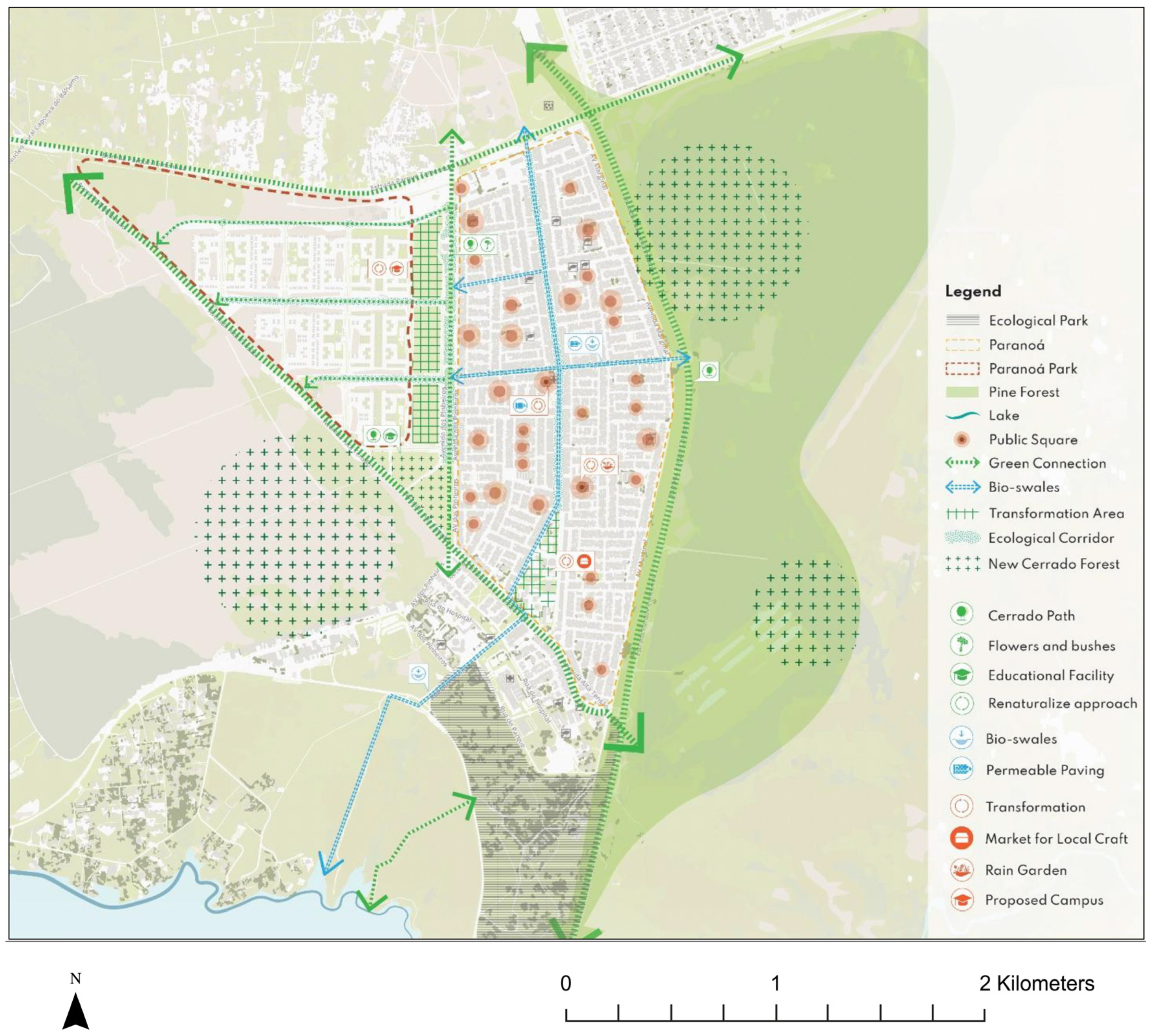
A synthesis map was hand-drawn, capturing the ideas from the community groups. The proposal identified the Ecological Park—the site of the original settlement—as a cornerstone of the GI strategy and suggested enhanced pedestrian and cycling connections leading from the park to the civic triangle and the main north–south avenue.
To address flooding and improve the urban environment for cyclists, the main north–south and east–west avenues were proposed to feature bioswales in their central reservations. These would also function as ecological corridors running across Paranoá. It was suggested that roundabouts be converted into rain gardens, improving stormwater management while integrating natural elements into the urban landscape.
A green belt was envisioned, including the pine plantation to the east. A key recommendation was to replace the invasive pine trees with native Cerrado species, thereby enhancing biodiversity and providing multiple ecosystem services. The western edge of Paranoá would be transformed into an eco-educational Cerrado trail, fostering environmental education and offering recreational opportunities. This area would also feature a triangular-shaped zone intended as a ‘Cerrado forest’.
The squares would undergo requalification, incorporating rain gardens and other nature-based interventions to reintroduce nature into urban spaces. Additionally, permeable paving was recommended to replace conventional materials wherever possible, supporting stormwater management and reducing the urban heat island effect.
This holistic proposal emphasises water management through nature-based approaches, the integration of nature into the urban fabric, and ecological restoration. The strategy is shown in
Figure 2.
3.2. The Cerrado-Based Climate-Resilient Belt
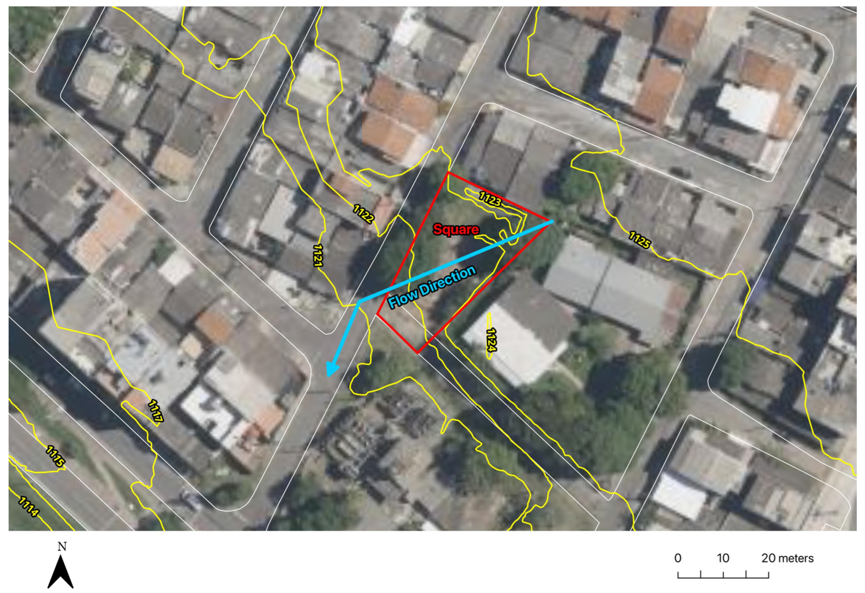
The definition of the pilot NBS was anchored in the work conducted at the ULL. The criteria for site selection were as follows: (1) high soil sealing; (2) a location with significant issues related to stormwater management and high temperatures; (3) a site where the local support and direct involvement of residents could be ensured for the transformation; (4) an availability of resources for a transformative intervention; (5) the potential to define a novel typology of NBS. Based on these criteria, the Square of Block 09 (Praça da Quadra 09) was chosen as the site for the pilot. Due to the slope of the terrain, this area was particularly prone to flooding during the rainy season (
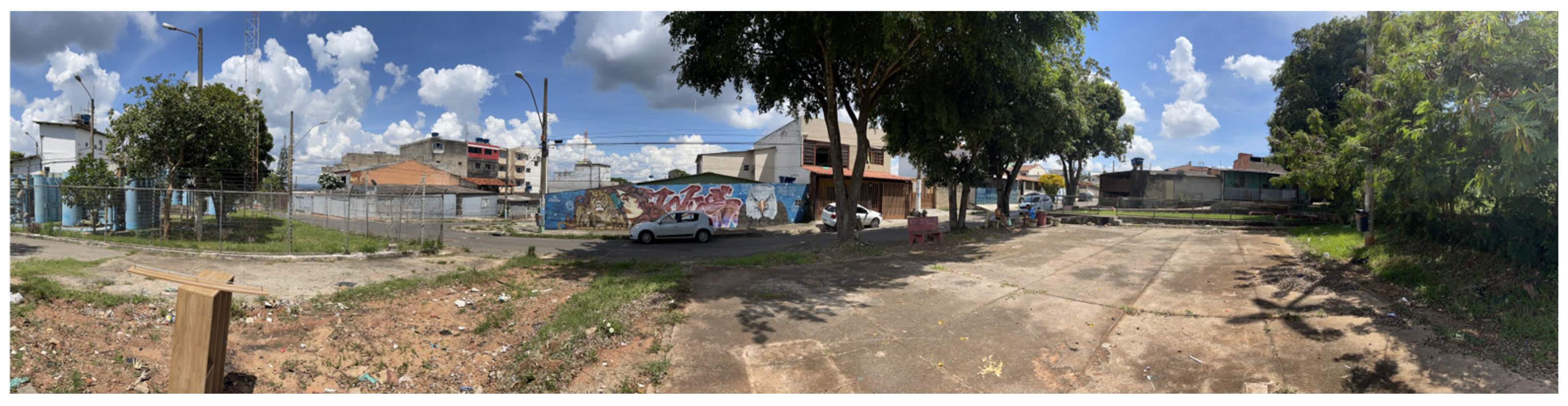
Figure 3). Similarly to the other squares in Paranoá, the Square of Block 09 was highly impermeabilized (
Figure 4). An asphalted dead-end road dominated its southern end.
There was a playground at the northern end of the square, but the public administration removed the play equipment as it became unsafe over time, and no replacement was made. In the centre, there is an open-air gym. The space was derelict and underused, with frequent fly-tipping incidents and security concerns.
Having identified the site and understood the issues at stake, the team began envisioning what the Square of Block 09 could become, considering the project’s climate adaptation and placemaking objectives. This phase of the ULL took place primarily online, with fortnightly meetings, on average, over several months to develop the brief and the plans for the square. The meetings were attended by the research team, members of the community, and representatives of the public planning departments. It is worth noting that representatives from CEDEP were directly involved in the online ULL activities to define the pilot project, reporting often to the broader community. A discussion session with the community to discuss the preliminary project was held in person at CEDEP in July 2024. It was evident that the NBS pilot was deemed to have met the residents’ expectations and hopes.
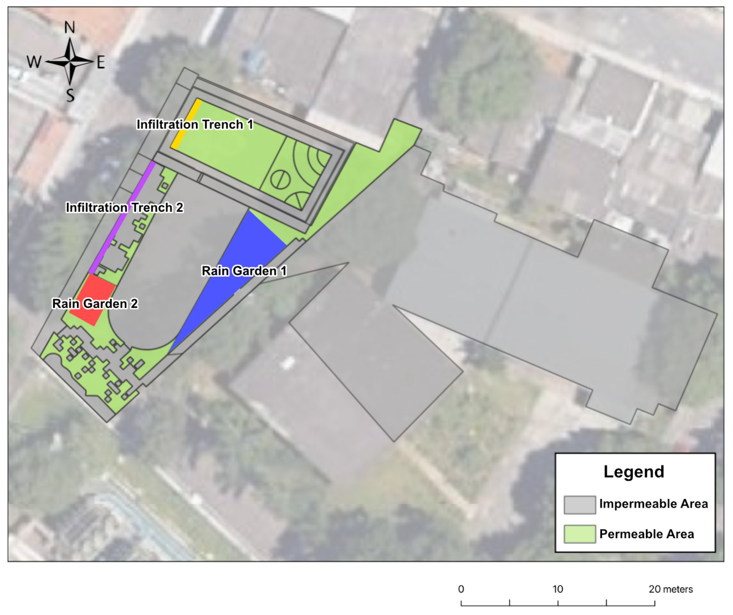
The main goal was to design a resilient, biodiversity-rich, and sociable space through the implementation of a novel typology of nature-based solutions. Stormwater management was a central focus, with the objective of transforming the square to locally manage all rainwater falling on it, as well as most of the rainfall occurring on CEDEP’s plot. This project, hence, established what we termed a Cerrado-based climate-resilient belt along the perimeter of the square, consisting of infiltration trenches and rain gardens. The intervention serves as a stormwater capture, purification, and infiltration system.
The design principles focused on maximising soil permeability, ensuring that the square would be well connected to its surroundings, encouraging people to stay and engage with the space, embracing existing uses, and minimising waste and cost. Enhancing biodiversity was also a key priority. During the design process, the dead-end road was incorporated into our vision for the square’s future as part of the climate-resilient garden belt.
Modelling of NBS Performance
Calculations were performed to size our infiltration measures. Regarding the hydrological modelling, the Rational Method is one of the most widely used rainfall–runoff models and is particularly recommended for basins with a contribution area of up to 2 km
2 [
64]. To calculate the inflow (Q
a), it was assumed to remain constant during the rainfall event, and was adjusted by a coefficient of 1.25 [
65]. The equation is as follows:
where
inflow rate in L/s;
total contribution area in hectares (ha);
surface runoff coefficient, dimensionless;
rain intensity, calculated by the Federal District IDF equation;
regulatory flow rate, which, in the case of the Federal District, is equal to 24.4 L/s ha, according to ADASA Resolution No. 26/2023.
This method estimates the flow based on the contribution of surface runoff, with adjustments for local rainfall intensity and regulatory requirements. To determine the volume of the control measures, the filling volume (Vp) must be calculated for rain events of different durations (td) until the maximum volume is identified.
Hydraulic modelling, in turn, consists of determining the volume for each compensatory measure. The filling volume (V
p) is calculated for rainfall events of varying durations (td) until the maximum volume predicted by the hydrological model is reached. The geometry of the measures must be iteratively adjusted to match the predicted volume [
65]. To calculate the compensatory measures, the first step was to determine the precipitation intensity using the region’s IDF (intensity, duration, and frequency) curve. This IDF curve relates the maximum precipitation intensity to the duration of the event and the likelihood of it being equalled or exceeded [
64].
As outlined in the Terms of Reference for urban drainage projects in the Federal District of NOVACAP [
61], the following IDF curve was used:
where
critical rainfall intensity in L/s ha;
return period in years;
rainfall duration in minutes.
The next step involved analysing the contribution areas, which are surface boundaries where the runoff occurs, carrying water to a specific point. These areas are defined based on the region’s topography and the location of hydraulic structures.
Finally, the surface runoff coefficient (C) represents the ratio of the amount of water that precipitates to the amount that runs off in a given area with a particular type of soil cover. The more impermeable the surface cover, the higher the coefficient will be. The NOVACAP Terms of Reference [
61] recommend the values listed in
Table 1.
Based on the permeability rates of land use and occupation in the study region (
Figure 5), each area was classified into two categories to calculate the project’s weighted runoff coefficient: impermeable areas, which include paved or waterproofed surfaces, and permeable areas, which consist of fully grassed surfaces.
The runoff coefficient for each control measure was determined using the weighted average of the permeable and impermeable area proportions within each contributing area. The formula is as follows:
where
= weighted runoff coefficient of the contribution area;
= portion of the contribution area classified as permeable area in m2;
= portion of the contribution area classified as impermeable area in m2;
= total contribution area in m2.
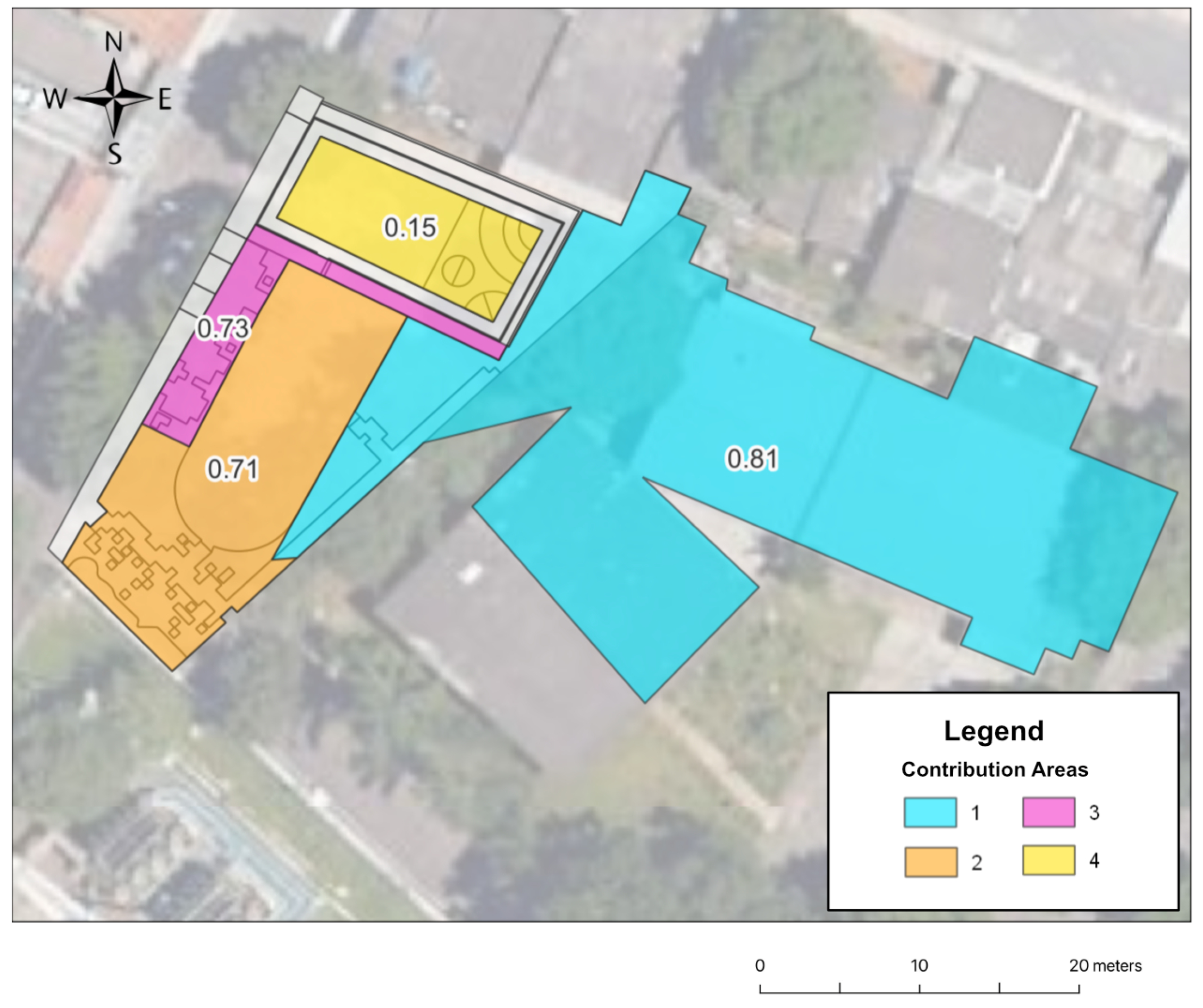
The results of the weighted coefficients for the contribution areas can be seen in
Table 2. It is important to note that the calculation only considers the areas within the contribution zones of the proposed control measures, including their specific land uses.
In
Figure 6, the contribution areas are shown with their respective surface runoff coefficients, which were used to calculate the depth of the NBS elements, with their shape defined by the urban design.
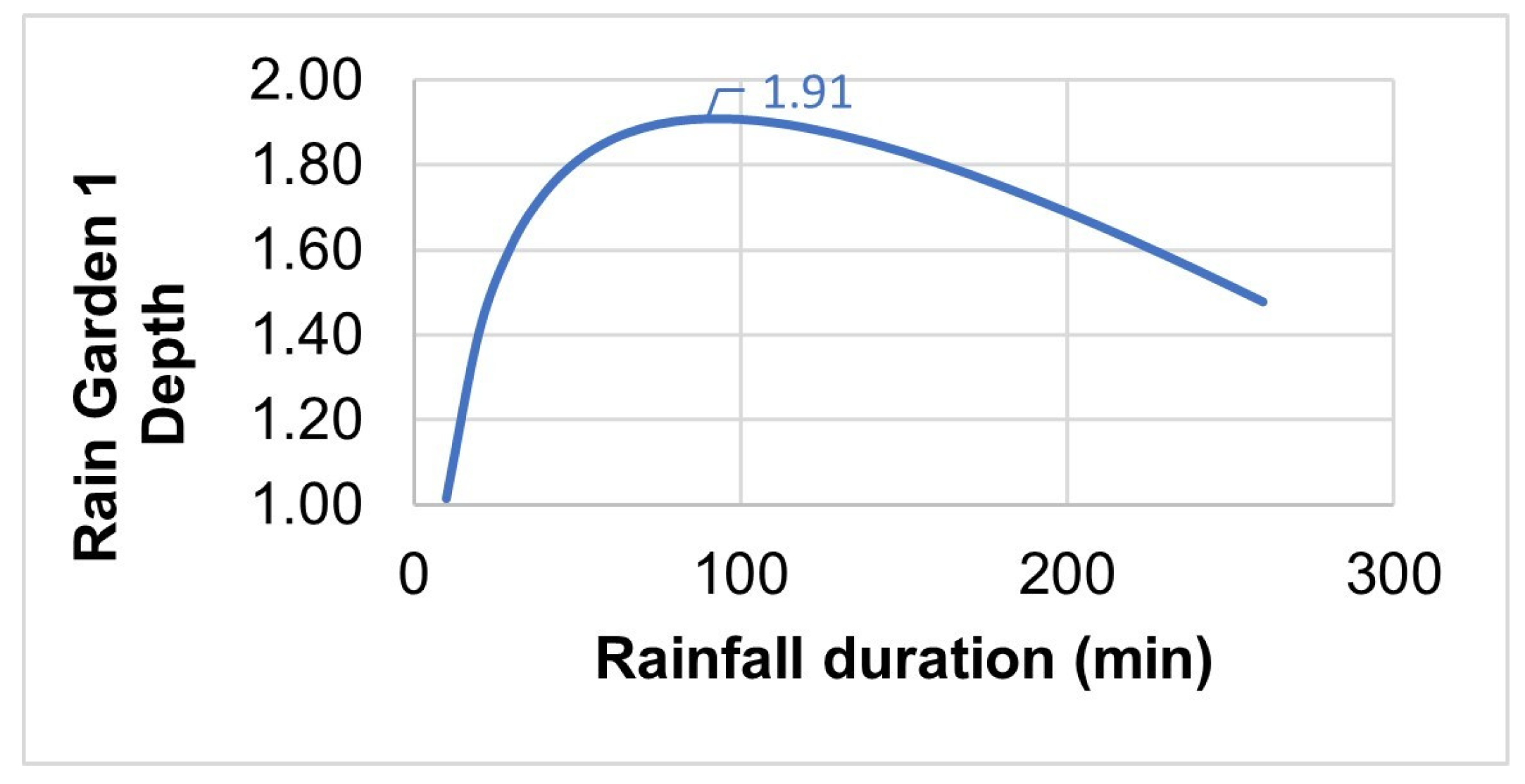
Rain gardens and infiltration trenches were defined for the project. The geometric volume of Rain Garden 1, which has a triangular shape, is equal to
where
base of the triangle in m;
height of the triangle in m;
height of the water level in m.
The infiltration area of the proposed geometry must also be considered. For Rain Garden 1, this is equal to the bottom area plus the side area:
where
hypotenuse of the triangle in m.
Using the geometry parameters presented in
Table 3, and the local parameters of the study area in
Table 4, the iterative process was conducted to obtain the depth for Rain Garden 1, as shown in
Figure 7. A freeboard of 10% above the water level was adopted, i.e., 1.1 × H; hence, the estimated depth resulted in 2.10 m.
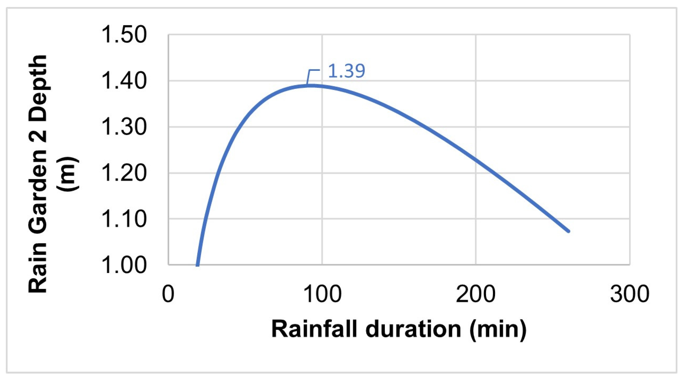
Similarly, the process was repeated for Rain Garden 2. The volume for this garden was calculated using the following formula:
where
b = length of the rectangle in m;
L = width of the rectangle in m;
H = height of water level in m.
The volume equation was refined as
The infiltration area, which consists of both the bottom area and the side areas, was calculated as
The geometric and local parameters of Rain Garden 2 can be found in
Table 5 and
Table 6. Also considering a freeboard of 10%, the calculated depth of Rain Garden 2 was 1.53 m (
Figure 8).
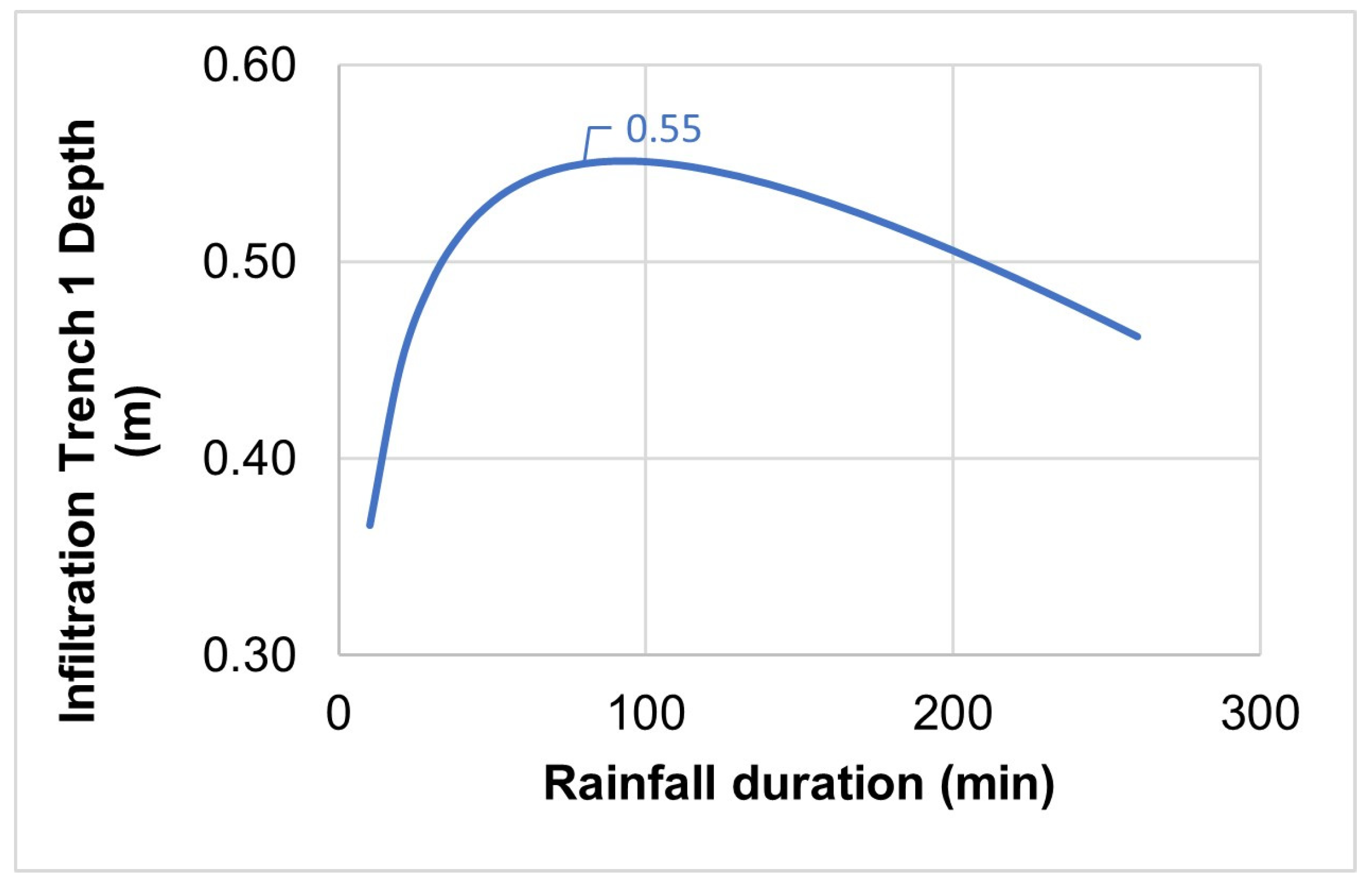
The sizing of the infiltration trenches followed a similar approach. It is important to note that the geometry of the two proposed trenches is similar, with a significantly greater length than the width and depth. The volumes (Vp) of the infiltration trenches were calculated using the following formula:
where
trench width in m;
trench length in m;
height of water level in m;
longitudinal slope in m/m.
As recommended by ADASA, the infiltration area for the trenches, considering the bottom area and half of the side areas, is calculated as
For Infiltration Trench 1, the parameters are presented in
Table 7 and
Table 8. Also, by adopting a freeboard of 10%, the calculated depth of Infiltration Trench 1 was 0.61 m (
Figure 9).
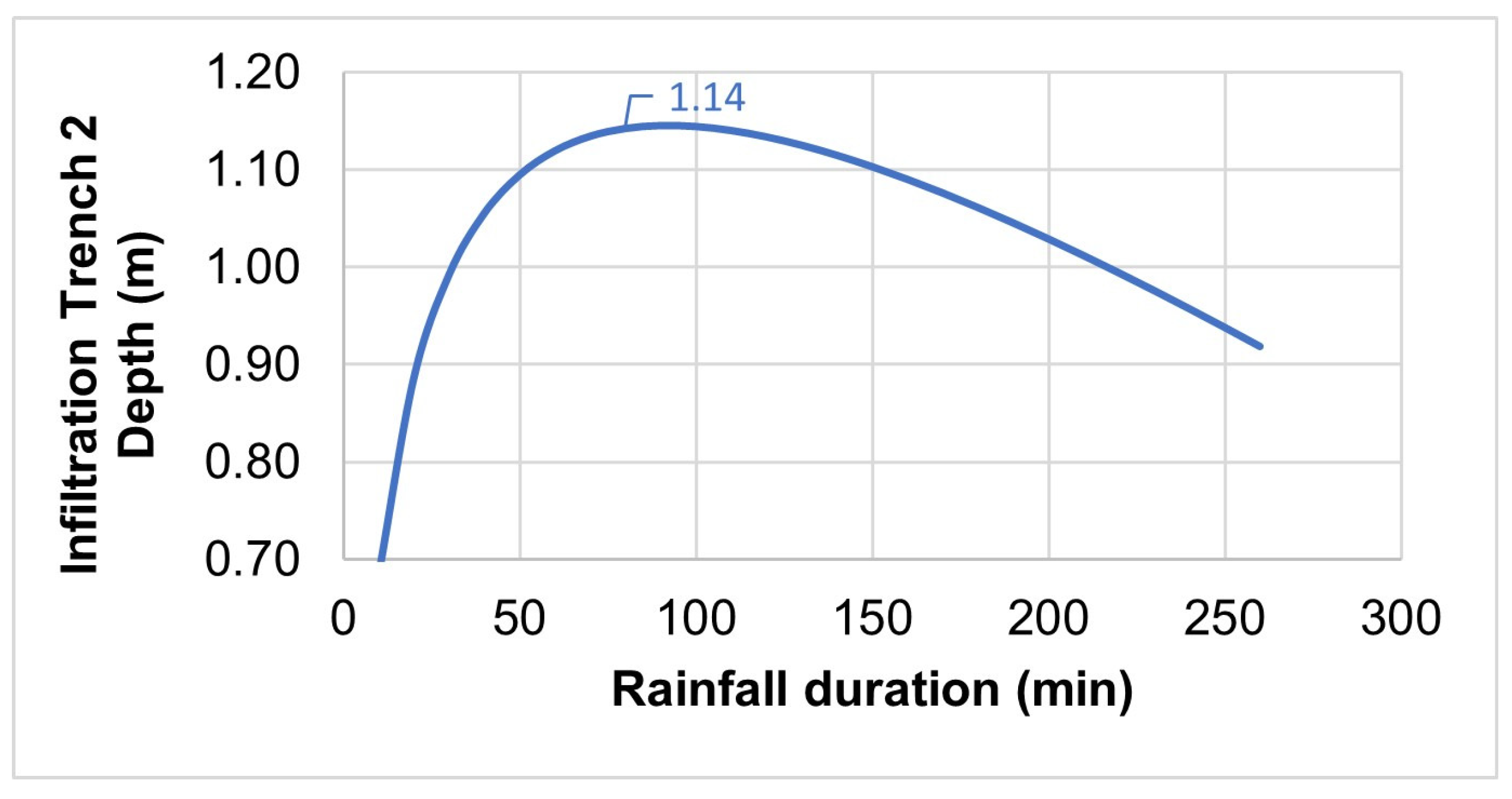
For Infiltration Trench 2, the data and results are presented in
Table 9 and
Table 10. Also, by adopting a freeboard of 10%, the calculated height of Infiltration Trench 2 was 1.26 m (
Figure 10).
The proposed stormwater control measures—rain gardens and infiltration trenches—have been sized to ensure that the system effectively captures and manages runoff from the Square of Block 09. The iterative design process ensured that the required storage volumes were met while accounting for the site’s hydrological and geometrical constraints. The resulting design will significantly reduce surface runoff, promote infiltration, and improve local water quality, aligning with climate adaptation and sustainable urban water management goals.
4. Discussion
The results underscore the pressing need to address critical issues such as soil impermeability, which exacerbates the impacts of climate change, affecting the quality of life and the resilience of cities in the Global South [
66], as seen in Paranoá. However, this effort must be integrated into a holistic co-creation process that considers the socio-cultural needs and aspirations of the communities involved. NBS are crucial approaches to articulate different agendas and simultaneously address multiple challenges [
67]. Our findings align with research on ULLs, emphasising the importance of co-creation processes in adopting NBS and their long-term viability [
57,
68].
While many studies on the environmental benefits of NBS for water management focus on performative aspects [
69,
70], this research demonstrates that, through carefully designed participatory activities, initial community ideas of nature as a bringer of beauty and a symbol of engagement with the site’s history and biome could be expanded to consider how nature-based interventions could also reduce the impacts of climate change, making their environment more resilient and their quality of life better. The importance of NBS’ aesthetic dimension for residents has been explored in the literature [
8,
71], as well as their relation to memory [
72]. This study contributes to the literature by accentuating the benefits of the bidirectional exchange of local and technical expertise, moving from history to the future, in fostering contextually relevant and performative NBS.
Although stormwater management and urban temperature reduction were not initially priorities for the residents, they soon recognised their significance and the potential of NBS to integrate local socio-cultural values with ecological performance, creating multifunctional landscapes. This stands in contrast to cases where community engagement was considered to have hampered sustainable outcomes [
73]. Accordingly, attention was given to aspects such as the use of brainstorming techniques and collective mapping to analyse public space, as well as to understanding local perceptions of nature and the values associated with it. This approach was adopted to ensure that the community recognised itself in the project and its implementation. By blending technical expertise with residents’ voices and experiences, critical issues were identified, leading to tailored intervention proposals, ensuring that the solutions were both expert-informed and community driven.
This process can be transformative. In the context of sustainability, transformative change has been defined as a fundamental alteration in socio-ecological interactions in ways that support biophysical systems while meeting human needs [
74]. This project acted as a trigger for shifting mindsets towards environmental consciousness and nature-positive and resilient spaces. Such a shift happened during the co-creation process and will be enhanced as residents engage with the implemented solutions. Their lived experience in using the new square will provide day-to-day contact with NBS in action—reducing flood events, improving biodiversity, reducing temperatures, and providing sociable and beautiful spaces for them—further spreading the understanding of the effectiveness of these measures. Under these circumstances, NBS can be the key to unlocking better living conditions and more resilient environments for people and the more-than-human world.
This research showed that catalysing participatory processes that saw the residents’ needs expressed, heard, and acted upon empowered the community [
75] by the knowledge gained in NBS and urban resilience and through the fact that, by working together, a pilot project was designed and constructed on their doorstep, bringing significant benefits to the community. Moreover, it became evident that in collaborations where multiple stakeholders are engaged and committed to bring about transformative change, the community’s voice becomes stronger, and the possibility of concrete action is higher. These findings are in line with research that showed that transformative adaptation to climate change involves the anticipation of climate change impacts through design strategies, leading to more sustainable and resilient outcomes [
76].
In addition, combining the qualitative methodologies employed in the ULL with the quantitative assessments and modelling of ecosystem services, such as water management, enhances the possibility of developing NBS that both respond to the local socio-cultural context and needs and can perform at the level of environmental and ecological benefits. This approach adds to a recent body of work articulating socio-cultural values and positive human–nature relationships with performance-based urban planning and design research [
77].
The calculations performed in this research demonstrate the efficacy of the proposed nature-based solutions (NBS) in significantly reducing stormwater runoff and enhancing infiltration capacity, aligning with the existing literature advocating for sustainable urban water management [
20,
26,
37]. The calculated depths for rain gardens and infiltration trenches illustrate a precise alignment between hydrological modelling and urban design, underscoring the importance of context-specific sizing to optimise performance. Such results resonate with findings in prior studies emphasising that appropriately sized NBS elements not only manage runoff effectively, mitigating urban flooding risks, but also enhance groundwater recharge [
24,
62]. Furthermore, the integration of quantitative performance modelling within community co-creation processes advances the existing literature by demonstrating how technical precision can coexist with community-driven environmental stewardship.
Moreover, the iterative process employed in modelling and sizing these interventions highlights the necessity of integrating adaptive and responsive methodologies in urban planning, especially within the complex socio-environmental contexts of cities in the Global South. The results show that even in highly impermeabilized urban areas, such as Paranoá, significant improvements in resilience can be achieved through targeted, community-informed interventions. This aligns with previous research advocating for tailored NBS approaches that consider specific local hydrological and socio-cultural conditions [
66,
78].
Consequently, integrating rigorous quantitative analyses into participatory planning processes can significantly enhance the viability and sustainability of NBS, fostering both community ownership and measurable environmental performance. These findings confirm the importance of continued investment in integrated methodologies, supporting the creation of more resilient and equitable urban environments in similar contexts globally.
Lastly, the research has advanced the understanding of how NBS can effectively manage stormwater in cities [
78,
79,
80]. In the face of the compounded effects of the polycrisis—climate change, biodiversity loss, and urban inequalities—the multidimensional performance of landscapes must be prioritised [
81]. The results corroborate the need for a shift in understanding water-based interventions as a path towards ‘sponge’ cities and urban resilience [
18], evidencing that such transition is facilitated when socio-cultural values and environmental performance are aligned. This study contributes a significant example to the growing body of pilot cases worldwide leveraging nature-based processes to transform neighbourhoods and cities [
15,
28,
82].
The process and methodologies employed in this research have strong replicability potential. While the Cerrado-based climate-resilient belt was designed for a specific context, it can be adapted to other locations. This requires bridging the gap between typological approaches found in NBS catalogues and the empirical, bottom-up innovation process in NBS. This research demonstrates that there can be a dynamic interaction between deductive and inductive processes in NBS development, fostering locally grounded yet globally relevant NBS that can be adapted or reinvented across diverse contexts.


 ,
, 
