1. Introduction
Amidst the escalating global climate crisis, reducing carbon emissions and achieving a low-carbon transition have become an urgent, shared mission for the international community. Territorial space, as the fundamental platform for all human socio-economic activities and a major site of carbon emissions, is also crucial for realizing carbon sequestration [
1]. Its development patterns and trends are intricately linked to carbon emissions and the sustainable development of the society and economy [
2]. Different modes of territorial space utilization significantly affect greenhouse gas emission levels. For example, the acceleration of urbanization and industrialization has led to excessive exploitation of land resources and the inefficient spatial distribution of energy-intensive industries [
3,
4], resulting in substantial greenhouse gas emissions [
5]. The systematic optimization of territorial space utilization patterns could enhance ecosystem carbon sequestration capacity, while reducing land use-related emissions [
6].
Globally, the patterns of territorial space utilization and associated carbon emission characteristics exhibit significant heterogeneity across nations, primarily attributable to disparities in development stages, resource endowments, and policy orientations. Developed countries have progressively integrated low-carbon principles into territorial space planning and governance, achieving measurable emission reductions through strategic urban design, optimized industrial layouts, and renewable energy deployment [
7,
8]. In contrast, developing nations face the dual pressures of economic growth and low-carbon transition during rapid industrialization and urbanization [
9]. Their territorial space development intensity has increased to meet expanding socio-economic demands, inadvertently elevating carbon emissions in major emerging economies [
10,
11]. Concurrently, technological and financial constraints hinder the effective implementation of low-carbon spatial planning strategies [
12,
13]. This divergence underscores the critical need for developing countries to accelerate the establishment of low-carbon territorial space frameworks. Such transformation represents a vital pathway for reconciling developmental imperatives with climate commitments, ultimately fostering sustainable territorial space governance systems.
As the essential carrier for human activities, territorial space has become an increasing focus of academic research, especially concerning its utilization assessment. The key themes in evaluating territorial space utilization include its structure [
14,
15], resilience [
16], efficiency [
17,
18], suitability [
19,
20], and conflicts [
21,
22,
23]. These studies typically follow a framework of “functional division–multiple evaluation–optimization regulation”. Initially, territorial space is categorized based on function into urban, agricultural, and ecological spaces [
24,
25]. Following this classification, an appropriate measurement indicator system is developed. Various methods, such as the SBM model [
26], DEA model [
27]), TOPSIS [
28], and weight summation method [
17,
25], are employed to assess territorial space utilization across different geographical regions. These studies contribute to the assessment and optimization of the allocation and utilization of territorial resources. However, they often neglect carbon emission factors, hindering a comprehensive assessment of the environmental costs of territorial space utilization, which is crucial for achieving balanced economic, social, and environmental development.
In fact, with growing concerns about climate change, some studies have incorporated low-carbon perspectives into the evaluation of territorial space utilization. These investigations can be categorized into two types. The first focuses on specific categories of territorial space, particularly urban and agricultural spaces, examining the spatiotemporal variations and underlying driving factors of their LCU [
29]. For instance, Wu et al. (2022) analyzed the urban land use efficiency of 91 cities in China’s Yellow River Basin under low-carbon emission constraints [
30]. Kuang et al. (2020) integrated carbon emissions into a cultivated land use efficiency evaluation framework, employing a slacks-based measure model with undesirable outputs to assess the low-carbon utilization of farmland across 31 Chinese provinces [
31]. The second category reflects an evolving understanding of integrated territorial space development, where scholars have begun adopting more systemic approaches to evaluate the LCU of territorial space. Zhang et al. (2023) established a carbon emission measurement methodology for territorial space and conducted a comprehensive spatial differentiation analysis of low-carbon development efficiency in Suzhou, China, considering economic, social, and ecological dimensions [
32]. Chen et al. (2024) investigated the spatiotemporal characteristics of territorial space utilization efficiency in resource-based cities along the Yellow River Basin through input factors, desirable outputs, and undesirable outputs under dual carbon goals, while identifying driving factors from both natural and socio-economic perspectives [
33].
While progress has been made in evaluating the LCU of territorial space, several critical aspects require further exploration. First, existing studies have not sufficiently clarified the correlation between territorial space functional types and carbon emissions, hindering the effective assessment of LCU outcomes. Second, the current research predominantly concentrates on specific space categories, like urban and agricultural areas, lacking comprehensive systemic perspectives. Regarding evaluation metrics, the selection process remains problematic, as indicator systems often prioritize quantity over precision, leading to inconsistent results due to different index choices. Presently, there is a need for a concise and targeted evaluation framework. Furthermore, while most studies emphasize natural and socio-economic drivers, few have considered the influence of landscape patterns on the LCU of territorial space.
The Yangtze River Economic Belt (YREB), a national strategic area spanning eastern, central, and western China, integrates megacity clusters, agricultural production bases, and ecological barrier zones. Its LCU of territorial space proves crucial for regional sustainability and serves as a model for China and developing countries in carbon reduction. Distinct geographical disparities also across its upper, middle, and lower reaches create spatial heterogeneity in territorial development intensity and ecological vulnerability. Therefore, this study focuses on the YREB with the research objectives to systematically evaluate the LCU of territorial space and identify its underlying driving factors, thereby providing theoretical references and practical strategies for achieving coordinated development between low-carbon transition and territorial spatial planning in large-scale economic regions. Specifically, this research aims to resolve three key questions: (1) What is the correspondence between territorial space functional types and carbon emissions? (2) How can a targeted and direct assessment framework for LCU of territorial space be constructed? (3) What are the spatiotemporal evolutionary patterns and underlying drivers of the LCU of territorial space? The main innovative aspects of this study are as follows: Firstly, we have enhanced the clarification of the correspondence among functional types of territorial space, land use types, and carbon emissions. Building on this foundation, we established a systematic assessment framework for the LCU of territorial space, focusing on three functional types: urban space, agricultural space, and ecological space. This comprehensive perspective emphasizes the integrity and specificity of LCU, addressing certain limitations present in traditional assessments. Secondly, we have implemented spatial zoning based on the distinctive characteristics of the LCU of territorial space. Previous studies rarely adopted such a spatial classification approach from an LCU perspective, and this approach allows for the precise identification of the strengths and weaknesses of regional LCU, thereby providing theoretical support and practical reference for territorial space planning. Furthermore, we combined optimal parameter geographic detectors with a Tobit model to systematically explore the driving factors influencing the LCU of territorial space from three perspectives: natural factors, socio-economic factors, and landscape pattern characteristics. Existing studies have inadequately addressed the comprehensive exploration of these drivers, particularly overlooking the role of landscape pattern characteristics, thereby neglecting the impact of territorial space development patterns on the LCU of territorial space. Our approach provides critical insights into these underexplored interactions.
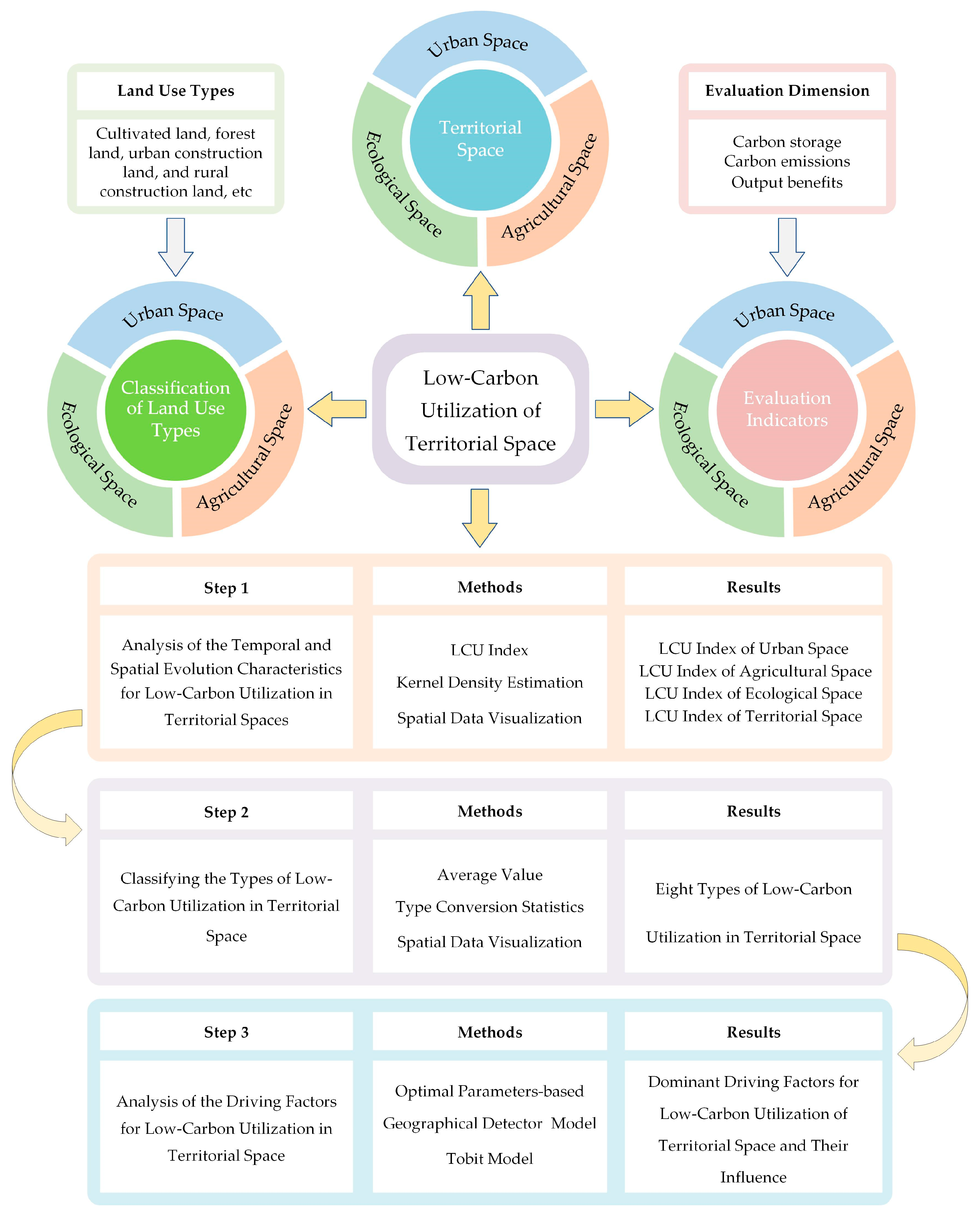
As illustrated in
Figure 1, the research framework operates through three phases. First, territorial space functional zoning is established to clarify carbon emission correlations across spatial categories. A tri-dimensional evaluation system integrating carbon storage, carbon emissions, and output benefit is developed to analyze the spatiotemporal evolution characteristics of LCU. Second, territorial space is classified into distinct LCU types to inform precise development strategies. Finally, a comprehensive driver analysis is conducted across natural foundational factors, socio-economic conditions, and landscape pattern indices. This study contributes novel perspectives for advancing green low-carbon development, optimizing territorial space utilization models, and achieving sustainable development goals, offering significant theoretical and practical implications.
4. Discussion
4.1. Exploring the Evolutionary Mechanisms of Low-Carbon Utilization of Territorial Space in the YREB
Territorial space, serving as the foundation for socio-economic activities and a carrier of carbon emissions, is crucial for LCU in achieving sustainable development goals. However, current research lacks a comprehensive assessment framework for LCU based on integrated territorial space functional types. Scholars typically focus on the LCU of single space types, particularly urban and agricultural spaces [
29,
30,
31], thereby failing to provide a systematic and comprehensive understanding of the LCU of territorial space. Existing evaluation systems often prioritize indicator comprehensiveness, with some indicators more suitable as influencing factors rather than direct assessment parameters. This approach overlooks the specificity and effectiveness of indicator selection. Given that one of our primary research objectives is to accurately assess the level of the LCU of territorial space, an excess or redundancy of indicators can lead to inaccurate results. Therefore, there remains a need for a concise and targeted assessment framework. Moreover, few studies have employed quantitative methods to explore how territorial space pattern optimization impacts LCU, which could provide valuable decision-making references for future territorial space planning. Considering these limitations, this research divides territorial space into urban, agricultural, and ecological spaces. We constructed a systematic LCU assessment framework from three perspectives: carbon storage, carbon emissions, and output benefits. Additionally, we comprehensively investigated the driving factors of the LCU of territorial space from natural, socio-economic, and landscape pattern characteristics, thereby addressing gaps in current research to some extent.
Our research indicates that the LCU of territorial space is a systematic and dynamic process, characterized by significant disparities among the functional spaces in different cities. These differences reflect the varying strengths and weaknesses in LCU across different functional spaces within the cities. Through the analysis of low-carbon utilization indices for urban, agricultural, and ecological functional spaces, we confirm that, while different cities may exhibit similar overall indices for the LCU of territorial space, substantial variations exist in the LCU performance of their respective functional spaces. This imbalance in LCU among functional spaces highlights the challenges of relying solely on carbon emission control or optimization policies focused on individual functional areas, which are insufficient for achieving the overarching goal of the optimized LCU of territorial space. Consequently, the coordinated advancement of LCU across urban, agricultural, and ecological spaces emerges as a critical mechanism for progressively enhancing overall territorial low-carbon performance.
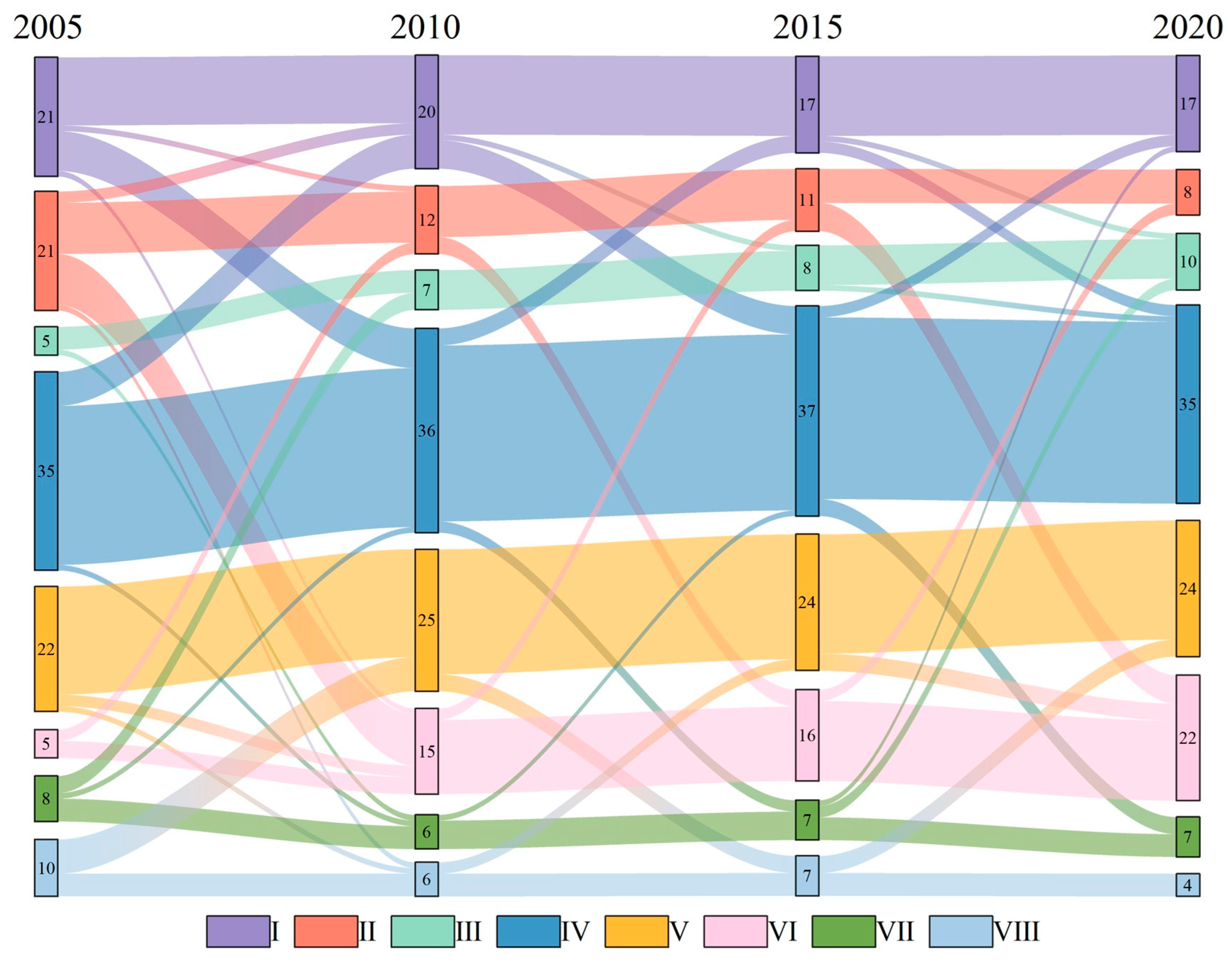
Our research categorizes cities within the YREB into eight types based on the LCU of territorial space. We found that only a few cities have achieved satisfactory low-carbon performance across all functional spaces. Over 80% of the cities exhibit poor LCU in at least one functional space, particularly in urban space, where the number of cities performing below the overall average is the highest. This trend indicates that inadequate LCU in urban space has become a significant barrier to the sustainable LCU of territorial space in the region. The underlying reasons for this situation are multifaceted. First, there are considerable regional development disparities within the YREB, with downstream areas exhibiting significantly higher economic development and technological innovation capabilities compared to the midstream and upstream regions. Second, there are marked differences in the industrial structures of cities within the YREB. Some cities still rely on energy-intensive and high-emission industries, which consume substantial energy and produce significant carbon emissions, negatively impacting LCU in urban spaces. Downstream regions also tend to transfer high-pollution, high-carbon emission industries to the midstream and upstream areas. Third, cities with relatively low economic development often lack sufficient financial and technical support to promote the development of low-carbon technologies and industries, hindering their capacity for low-carbon transformation in urban spaces. Despite the implementation of various policies and measures to foster development in the YREB, the lack of effective collaborative mechanisms among cities has made it difficult to establish a collective approach to regional low-carbon development. Consequently, many cities fall short in their LCU of urban space compared to the regional average. Connolly et al. (2022) revealed that urban households in 90 developing countries exhibit 2–9 times higher per capita carbon footprints than rural counterparts, aligning with the prevalent underperformance in urban space that LCU observed among most YREB cities to some extent [
73]. These findings underscore the urgency of improving urban LCU in developing nations. Conversely, economically advanced cities, like Singapore and Copenhagen, exemplify successful urban sustainability integration through nature-centric design, offering actionable models for developing economies [
74].
The dynamic evolution of the LCU of territorial space in the YREB is shaped by the interplay of natural, socio-economic, and landscape factors. Natural conditions—including topography, precipitation, and habitat quality—not only determine regional ecological carrying capacity but also indirectly influence land use patterns and carbon emission intensity. For instance, mountainous terrain may restrict urban expansion, while favorable climatic conditions enhance agricultural productivity. Socio-economic factors, such as industrial structure and technological innovation, act as critical drivers of LCU. Rapid industrialization and urbanization in the YREB have intensified energy consumption and carbon emissions. Addressing these challenges requires policies aligned with socio-economic transformation goals, including industrial restructuring and technological advancement. Landscape patterns, serving as spatial manifestations of natural and socio-economic interactions, exert significant influence on the LCU of territorial space in the YREB. The evolution of these patterns—such as urban expansion, rural settlement sprawl, farmland transformation, and ecological conservation—not only reshapes land use dynamics but also directly impacts carbon cycle processes. Consequently, low-carbon territorial spatial policies must prioritize the monitoring and optimization of landscape configurations. Rational spatial planning, which coordinates the development and allocation of functional zones (e.g., urban, agricultural, and ecological spaces), can enhance land use efficiency and carbon sequestration capacity. The strategic optimization of territorial spatial patterns is not merely a technical adjustment but a systemic pathway to achieving low-carbon land use and advancing sustainable development goals. Integrating landscape-driven insights into policy frameworks can foster synergies between human activities and ecological resilience, ensuring a balanced trajectory toward carbon neutrality.
In the YREB, Hangzhou stands out for its exemplary LCU of territorial space. Through a multifaceted approach that includes policy guidance, technological innovation, industrial transformation, and ecological development, the city has successfully achieved LCU of its territorial space, thereby providing a valuable case study for other cities and regions. In urban planning, Hangzhou has optimized its transportation system, advanced urban renewal projects, and promoted green building practices, which collectively have reduced traffic congestion and energy consumption, while enhancing the efficiency of urban energy utilization. In the industrial sector, the city has facilitated the green transformation of traditional industries, fostered the development of green low-carbon industries, and strengthened energy management, leading to significant reductions in carbon emissions in this field. Notably, Hangzhou has introduced mechanisms, such as “carbon accounts” and “carbon efficiency codes”, for enterprises to encourage energy savings and carbon reduction among industrial businesses. In agriculture, the city has promoted low-carbon farming models, developed ecological and circular agriculture, and leveraged digital technology to enhance production efficiency and resource utilization. In terms of ecological protection, Hangzhou has implemented measures to strengthen ecosystem preservation and restoration, including the improved protection of forest resources. Furthermore, through the development of green industries, such as ecological tourism, the city has achieved a synergistic development between ecology and economy.
4.2. Policy Recommendations
Building upon these findings, this study synthesizes the evolutionary characteristics and key driving factors of the LCU of territorial space in the YREB to propose corresponding policy recommendations. By aligning policy frameworks with the identified spatial evolution patterns and dominant drivers, the proposed strategies seek to enhance the coherence between regional development objectives and low-carbon governance mechanisms, thereby fostering a systematic pathway for achieving carbon neutrality in territorial spatial planning and utilization (
Figure 14).
- (1)
Optimizing planning and management of territorial space. Based on the natural environment, socio-economic conditions, resource distribution, and development potential of various regions within the YREB, it is crucial to identify the primary functions of each region and to clarify their dominant directions and development intensities, with an emphasis on integrating low-carbon concepts. The spatial layout of urban and rural construction land should be optimized by facilitating the redevelopment of idle and underutilized land, thereby reducing the fragmentation of rural homestead distribution. Establishing a comprehensive spatial planning system and implementing stringent land-use control measures will ensure the rational utilization of urban and rural construction land in accordance with the established low-carbon development objectives. Additionally, enhancing carbon sink capacity in urban and rural spaces can be achieved through measures such as increasing green space area, optimizing the layout of green spaces, and improving the quality of green areas, thereby promoting a balanced and stable carbon cycle. Furthermore, actively advancing comprehensive measures for land consolidation can enhance farmland aggregation, maximizing the economies of scale in agricultural production. The strict implementation of ecological land-use control systems, particularly for sensitive ecological areas such as forests and grasslands, is essential for strengthening the carbon sequestration capacity of ecosystems and facilitating a balanced and stable carbon cycle.
- (2)
Promoting the green upgrade of industrial structure and strengthening the drive for low-carbon technological innovation. Given the shortcomings in the LCU of territorial space in many cities along the YREB, it is essential to focus on transforming traditional industries characterized by high energy consumption, high emissions, and low added value. This transformation should involve the introduction of low-carbon technologies and equipment to enhance resource utilization efficiency and improve the levels of clean production. The government should encourage enterprises to increase their investments in emerging industries through policy guidance and financial support, with a strong emphasis on the development of strategic emerging industries, such as energy conservation and environmental protection. By fostering technological innovation, it is possible to improve energy utilization efficiency, reduce resource consumption and pollution emissions, and promote the transition of industries toward low-carbon and green development. In terms of transportation infrastructure, investments should prioritize the construction and improvement of public transportation systems, while optimizing the layout of transportation networks to enhance road efficiency and reduce energy consumption and emissions associated with traffic congestion. Furthermore, in the energy infrastructure sector, it is essential to increase investments in renewable and clean energy sources to promote the development and utilization of new energy, such as wind and solar power.
- (3)
Enhancing environmental regulation and strengthening social participation. It is imperative to strengthen environmental oversight and law enforcement, particularly focusing on the monitoring and assessment of key pollution sources to ensure their emissions comply with national and local low-carbon standards. The government should improve the environmental information disclosure system to enhance the transparency and reliability of environmental data, thus enabling the public and relevant agencies to stay informed about environmental conditions and take appropriate actions. Utilizing diversified public awareness and education methods can increase public recognition and emphasis on low-carbon development, guiding individuals to adopt green and low-carbon lifestyles and consumption patterns, such as sustainable transportation and energy conservation practices. This can foster a conducive atmosphere within society for promoting the LCU of territorial space. In this process, the government should develop incentive policies, such as low-carbon tax incentives and innovations in green financial products, to encourage public participation in low-carbon consumption and investment.
- (4)
Implementing targeted policies to promote regional collaborative development. Each city exhibits unique shortcomings in the LCU of territorial space, necessitating the clarification of regional development positioning and the formulation of differentiated low-carbon strategies. For resource-based cities, the focus should be on the conservation and circular use of resources to minimize waste and enhance utilization efficiency. In industrial cities, it is essential to facilitate the transition from high-carbon to low-carbon industries, while promoting the widespread application of low-carbon technologies. In ecological cities, priority should be given to strengthening ecological protection and restoration efforts to ensure sustainable green and low-carbon urban development. Furthermore, enhancing the regional industrial collaboration of low-carbon industrial chains is crucial for promoting the complementarity and synergy of industries across the upper, middle, and lower reaches of the YREB. The upstream regions can develop clean energy and raw material industries to supply green energy and high-quality materials to the middle and lower reaches, which can leverage their port and transportation advantages to advance high-end manufacturing and service industries, thereby driving industrial upgrading and low-carbon transformation. Centering on the LCU of territorial space, it is vital to explore the design of an ecological compensation mechanism for the YREB, aimed at balancing investments and returns in ecological protection and development across regions. This mechanism would ensure that high-carbon-emitting industries and regions bear corresponding economic responsibilities, thereby mitigating the negative impacts of environmental pollution transfer.
4.3. Limitations
Although this study has explored the spatiotemporal patterns and driving factors of LCU of territorial space in the YREB from multiple perspectives and levels, contributing to the theoretical framework for low-carbon development in territorial space, several limitations remain. The period of this study is constrained by data availability limitations concerning disaggregated sectoral carbon emissions, spanning only from 2005 to 2020—a limitation that remains currently unavoidable. Given that the LCU of territorial spaces constitutes a prolonged evolutionary process, this limited timeframe may inadequately capture long-term trends in regional LCU. Future investigations should prioritize longitudinal data tracking and analysis, potentially integrating household energy consumption surveys for urban and rural residents alongside sector-specific energy consumption surveys. Such efforts could facilitate the development of extended and updated time-series datasets for disaggregated sectoral carbon emissions, thereby enhancing assessments of sustainability and stability in the LCU of territorial space. Furthermore, the current sectoral carbon emission data in China predominantly focuses on the municipal administrative level, necessitating this study’s primary emphasis on city-level analysis. However, spatial heterogeneity in the LCU of territorial space may manifest at finer geographical resolutions. Subsequent investigations could refine analytical scales by selecting pilot cities to establish county- or township-level carbon emission inventories through coordinated household and industrial energy consumption surveys. This methodological advancement would facilitate granular analyses of low-carbon territorial space utilization at sub-municipal administrative units, potentially revealing microscale spatial dynamics and influential factors that remain obscured in broader-scale studies.
5. Conclusions
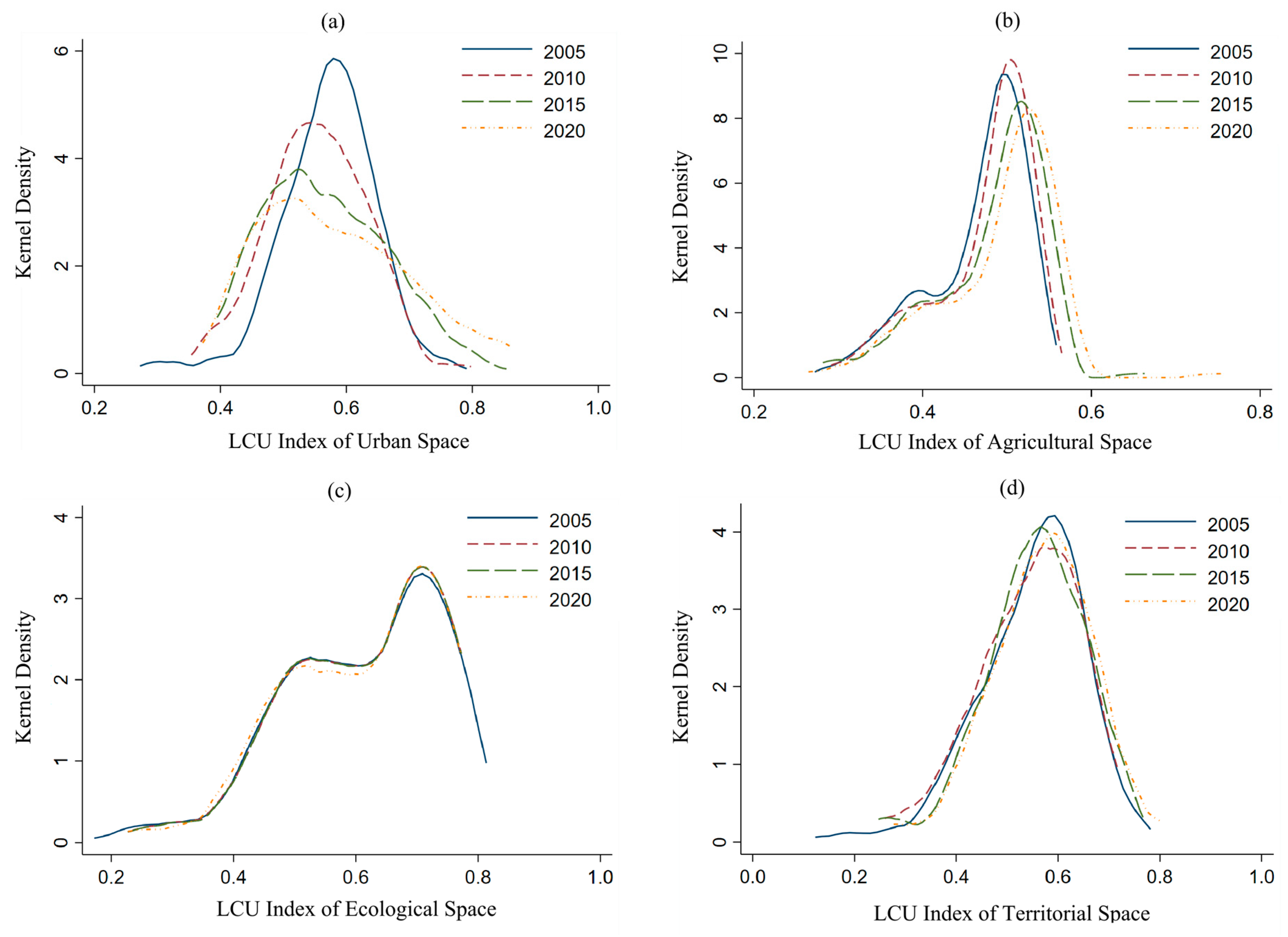
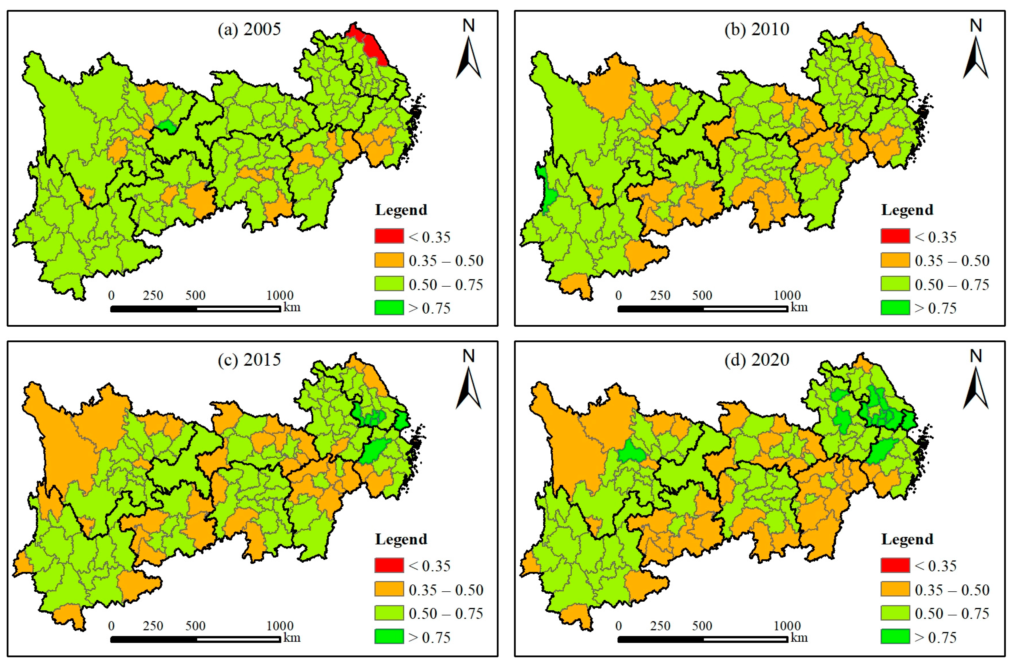
This study establishes a systematic assessment framework for the LCU of territorial space by integrating carbon storage, carbon emissions, and output benefits. By employing kernel density estimation and GIS spatial visualization, it reveals the spatiotemporal evolution patterns of LCU indices across functional spaces and territorial spaces in the YREB cities during 2005–2020, subsequently classifying them into eight distinct types. Additionally, optimal parameter-based geographical detector and Tobit regression models are employed to systematically investigate the key driving factors influencing the LCU of territorial space.
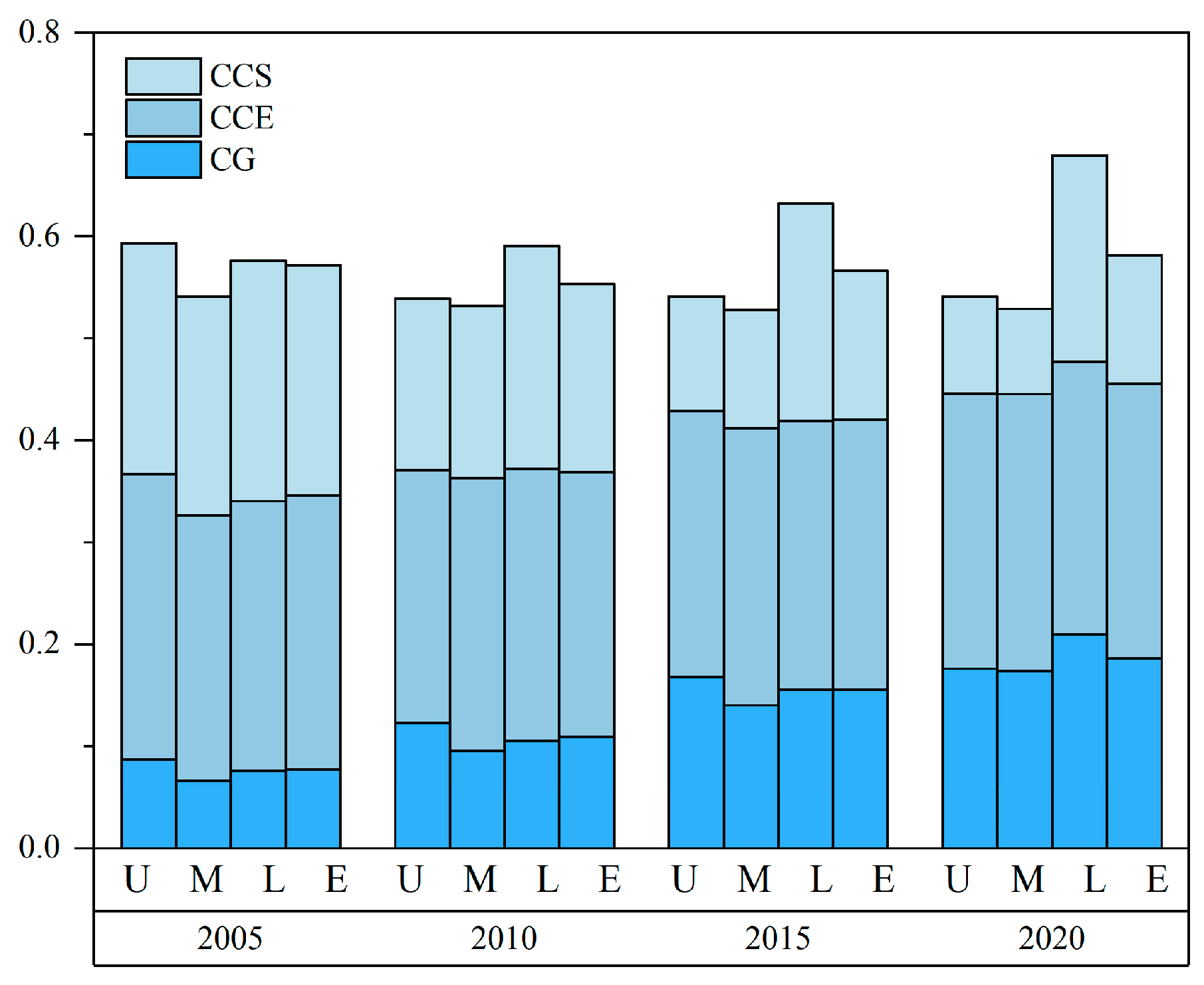
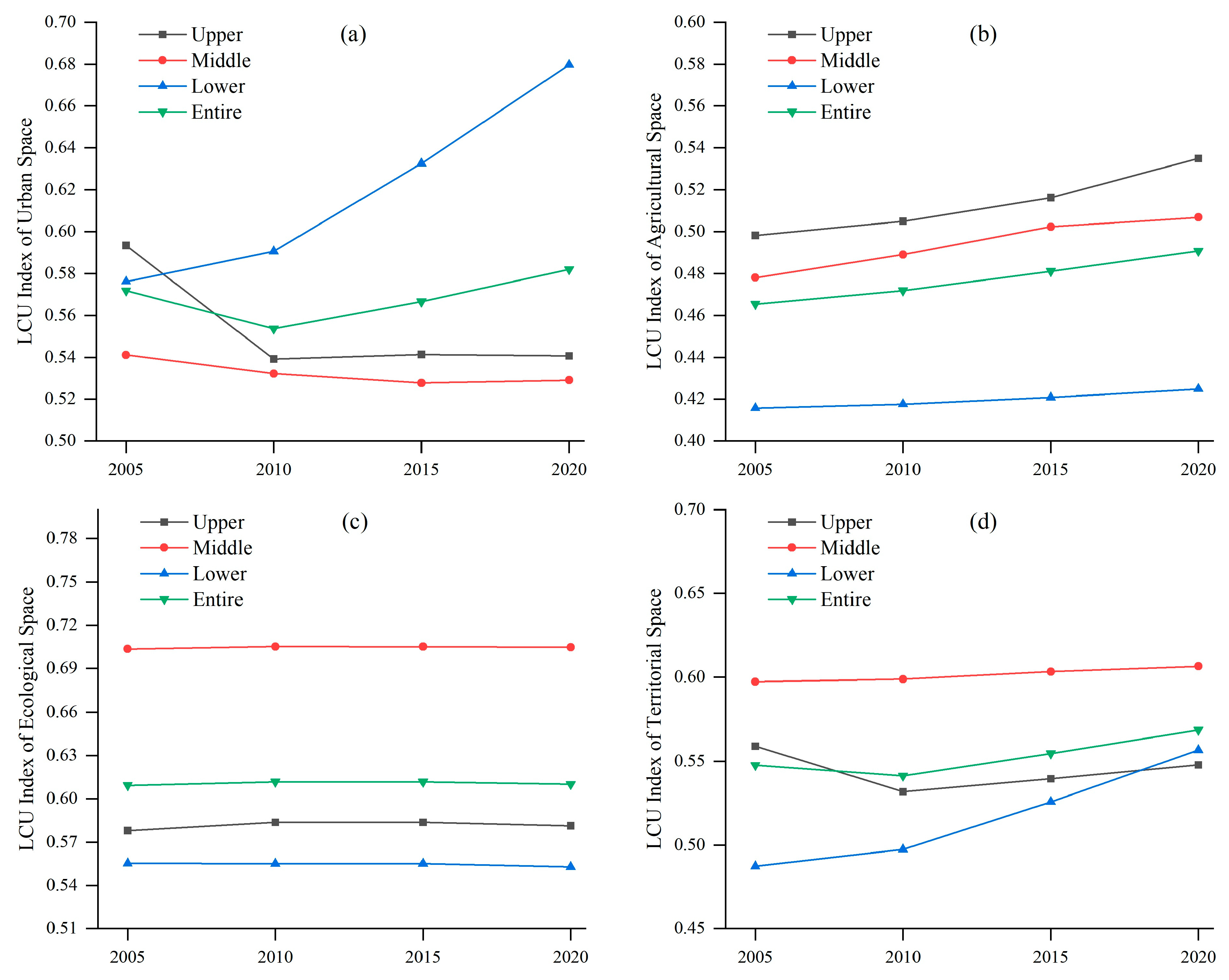
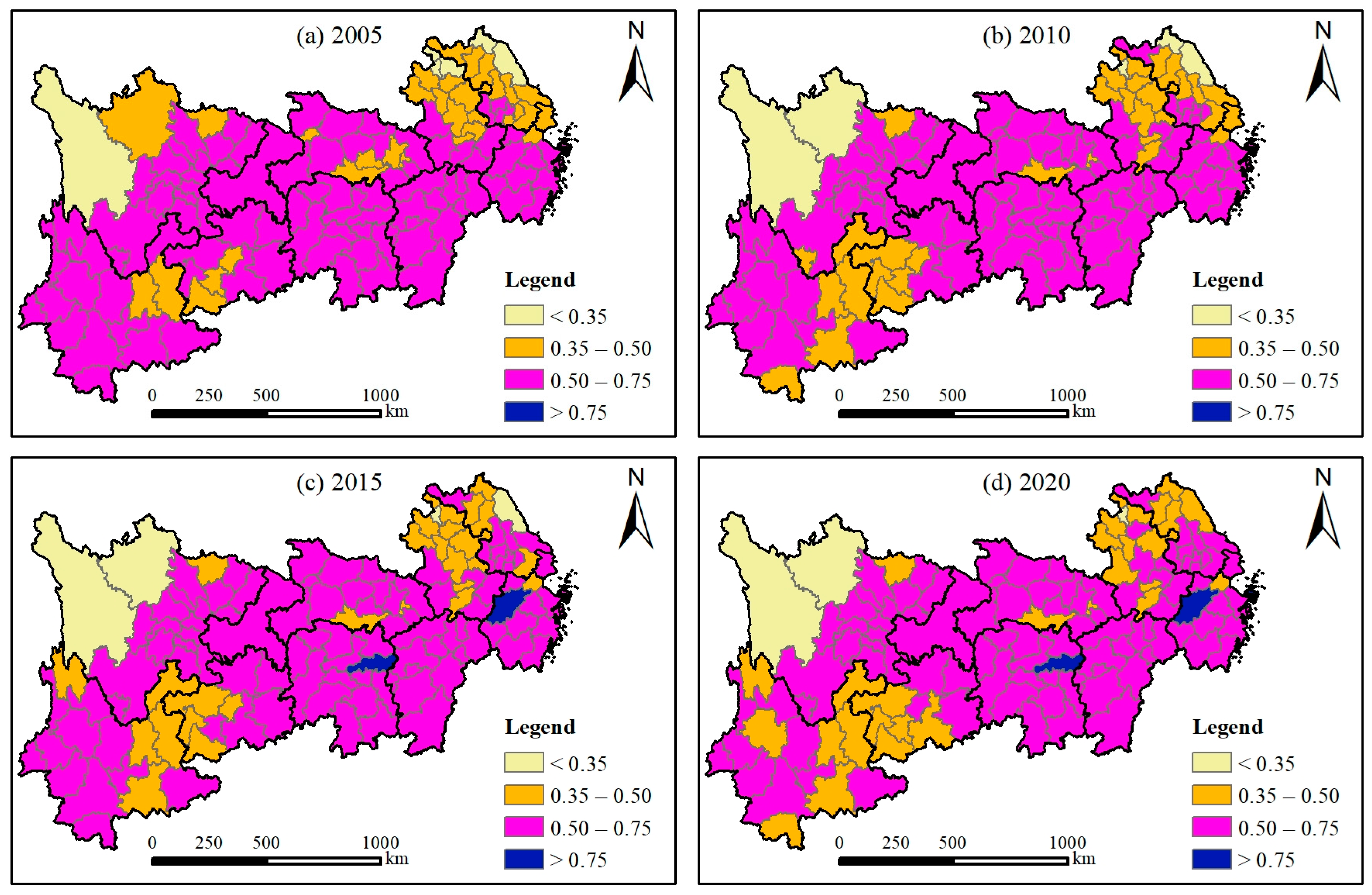
The principal findings are as follows: (1) The LCU index of territorial space in the YREB has shown an upward trend, fluctuating from 0.548 in 2005 to 0.569 in 2020. Regionally, the midstream area consistently exhibits the highest LCU index, while the downstream area surpassed the upstream area in this index after 2015. Different regions face varying shortcomings in the LCU of territorial space. (2) The cities within the YREB exhibit eight distinct types of the LCU of territorial space. Most cities demonstrate inadequate LCU in at least one functional area of territorial space. The first category includes cities that perform relatively well in LCU across urban, agricultural, and ecological spaces, with their proportion declining from 16.54% to 13.39%. Cities classified in the fourth category represent the largest group, accounting for approximately 28.35%; however, their poor performance in the LCU of urban space is a significant drawback. (3) The LCU of territorial space in the YREB is influenced by a combination of natural factors, socio-economic factors, and landscape pattern characteristics. Some factors exhibit a positive influence, while others demonstrate a negative impact.
This study also provides some insights for future research. Future investigations could apply the proposed assessment framework to evaluate LCU patterns across Asia or globally, enhancing its applicability in sustainable development contexts. Researchers may expand the analysis of driving factors by incorporating additional natural, socio-economic, and landscape pattern parameters beyond those examined here. Methodologically, while the optimal parameter-based geographical detector and Tobit regression models addressed challenges in the analysis of too many independent variables to some extent, further refinement of machine learning algorithms (e.g., random forests or XGBoost) could improve explanatory capacity for variable impact magnitude and direction. These extensions would strengthen policy-relevant insights into territorial space optimization under carbon neutrality objectives.


