Article

The “Gutâi-Maramureș” UNESCO Geopark Project Development and Heritage Values-Based Sustainable Tourism in the Gutâi Volcanic Zone, East Carpathians (Romania)

1
North University Centre of Baia Mare, Technical University of Cluj-Napoca, 430083 Baia Mare, Romania
2
Institute of Geodynamics, Romanian Academy, 020032 Bucharest, Romania
3
Faculty of Geology and Geophysics, University of Bucharest, 020956 Bucharest, Romania
4
County Museum of Mineralogy “Victor Gorduza”, 430212 Baia Mare, Romania
*
Author to whom correspondence should be addressed.
Land 2025, 14(4), 726; https://doi.org/10.3390/land14040726
Submission received: 31 January 2025 / Revised: 15 March 2025 / Accepted: 18 March 2025 / Published: 28 March 2025
(This article belongs to the Special Issue Geoparks as a Form of Tourism Space Management II)

Abstract

:
The “Gutâi-Maramureș” UNESCO Global Geopark project is to be realized in the Gutâi Volcanic Zone in the northwestern part of the East Carpathians (Romania), an area with long-lasting and complex Miocene volcanic activity and a centuries-long mining history. In order to identify the volcanism and mining-related patrimonial values, in combination with other natural and cultural assets able to support the establishment of a UNESCO geopark, and to develop a sustainable tourism in the area, this paper presents the main objectives of the adopted research methodology, namely to realize (1) a geological synthesis of the area, (2) an inventory and assessment of geological and mining heritage sites, (3) a synthesis of local biodiversity, and (4) documentation of the cultural, historical and archaeological values. Furthermore, we conducted a SWOT analysis to help define the optimal territory for the geopark, to establish the core values for a strong brand identity, and to develop educational and sustainable tourism activities. This paper presents all the significant heritage values located within the future geopark area: geosites of international scientific significance, sites related to centuries-long mining of precious metals, natural protected areas, including European Natura 2000 sites, important cultural heritage sites such as old wooden churches (five of them included in the UNESCO World Heritage List) and museums. The promotion of sustainable tourism in the area by harnessing all these patrimonial values could be realized by the implementation of the geoeducation and geotourism concepts during the project development based on previous experiences/activities in the area involving local people, NGOs and institutions.

1. Introduction

The geopark concept evolved during the late 1990s in the framework of an international LEADER project aiming to support rural communities’ development. The innovative approach was based on the use of local geodiversity and geological heritage not only as a new value but also as a fundamental natural value fostering biodiversity and playing a key role in shaping the cultural identity of local communities and generating unique landscapes. In 2000, four territories founded the European Geoparks Network (EGN) and laid the foundation for global collaboration and innovation in geopark management [1,2], leading to the creation of the Global Geoparks Network in 2004 and the development of a new specific UNESCO Program in 2015 [3]. The Global Geoparks Network developed continuously, and in 2025, the network spans 50 countries, with 229 territories, and more running geoparks projects, each playing a vital role in shaping a sustainable future [4]. Geoparks are regarded as the territories of the 21st century [5] because they develop a holistic approach to managing and preserving landscapes while addressing global challenges.

1.1. Previous Research

Romania was at the forefront of the geoparks movement and a significant contributor to the development of the concept, especially in the European context. The first geopark project, coordinated by the University of Bucharest, started in 2000 as a combination of scientific research, local initiative, and international collaboration. After five years of continuous work and a multistakeholder approach, the Hațeg Country UNESCO Global Geopark was validated as a member of the EGN and GGN in 2005. Its innovative approach in terms of education, interpretation, geotourism and adaptative management made the Hațeg Geopark a model and an inspiration for other new geopark projects. The Buzău Land UNESCO Geopark was initiated in 2007 as a partnership project between Buzău County Council and the University of Bucharest.
During the last few decades, geotourism has developed a lot worldwide based on the integration of the geodiversity and geoheritage concepts. The importance of the geodiversity concept has evolved starting from the early 2000s [6,7,8,9] to recognition at the UNESCO level by declaring the first International Geodiversity Day in 2021. More recently, a clearer conceptual distinction has been made between the geodiversity and geoheritage concepts. Geoheritage, as part of geodiversity, includes geodiversity elements with high scientific value and also with educational, aesthetic and cultural values [10,11]. The geotourism concept has also evolved from the promotion of the geological elements for tourism purposes [12,13] to sustainable tourism and promotion of the geoheritage and geoconservation concepts [14,15,16].
Consideration of the possibilities of harnessing the geodiversity potential for tourism purposes in the Gutâi Volcanic Zone (GVZ) started many years ago. The earliest and only steps taken during the communist period in Romania were made in the 1980s [17]. The term geotourism potential was used for the first time in Romania in the cited paper, with the authors defining it as “the totality of the geological objectives that are of tourist interest”.
The possibility of harnessing the geological, mining, historical–archaeological, ecological and cultural heritage values of the GVZ within a potential UNESCO geopark was first considered by Kovacs and Fülöp [18]. A related subject was addressed one year later regarding the management of geodiversity in the GVZ [19]. The geodiversity management of the Baia Mare region was thought to be a necessity to connect geodiversity values to other elements of natural and cultural resources for the development of a geotouristic network in the area. Several recent papers continued to consider the geological heritage sites in the GVZ from the perspective of its possible valuation within the framework of a potential geopark [20,21].

1.2. Scope

The “Gutâi-Maramureș” UNESCO Global Geopark project is to be realized in the northwestern part of the East Carpathians, part of the broader Carpathian–Pannonian region in Eastern Europe. The proposed geopark includes most of the Gutâi Volcanic Zone (NW Romania), an area with long-lasting and complex volcanic activity. Five towns, including Baia Mare city, the capital of the Maramureș county, and other eight communes, including many villages, located in the surrounding area of the volcanic zone are found within its territory. The development of the project just recently started (October 2024) in the framework of a partnership between Maramureș County Council, Bucharest University, “Victor Gorduza” County Museum of Mineralogy in Baia Mare and the NGO “Association for Tourism Promotion and Sustainable Development”.
This paper aims at presenting the results of basic scientific research conducted to answer the main question regarding the establishment of a new UNESCO geopark in Romania: how could the “Gutâi-Maramureș” UNESCO Global Geopark project be developed to fulfill the UGGp criteria and the local development needs? This study was focused on the following main directions: (1) to realize an inventory of all the patrimonial values found within the target area—geoheritage, mining heritage, natural/biodiversity and cultural heritage, considering the supporting elements in the assessment and accreditation of the geopark; (2) to develop a structured research methodology assisting the development of the geopark project; and (3) to identify the main pathways to develop sustainable tourism by harnessing all the inventoried patrimonial values. This paper addresses the significant supporting elements based on a SWOT analysis and presents the essential assets of sustainable tourism in the future geopark. The SWOT analysis helped us to define the optimal geopark territory and to establish the core values for a strong brand identity. Our research serves as a foundation for the geopark project development and implementation of the first steps to be taken.
Field-based investigations and literature–archive research conducted in the target area provided a solid and unprecedently detailed scientific background for the geopark project development. Thus, this paper highlights the geological, mining, natural and cultural heritage values and discusses how they can be valorized for the profit of the local peoples. As such, it is the first research initiative in the area to include (1) a full inventory of all the patrimonial values, (2) a proper methodology leading to the geopark project development, and (3) establishment of pathways for the promotion of sustainable tourism by the implementation of the geoeducation and geotourism concepts for the sake of the economic and social development of the local communities and their territory.

1.3. Geological Background

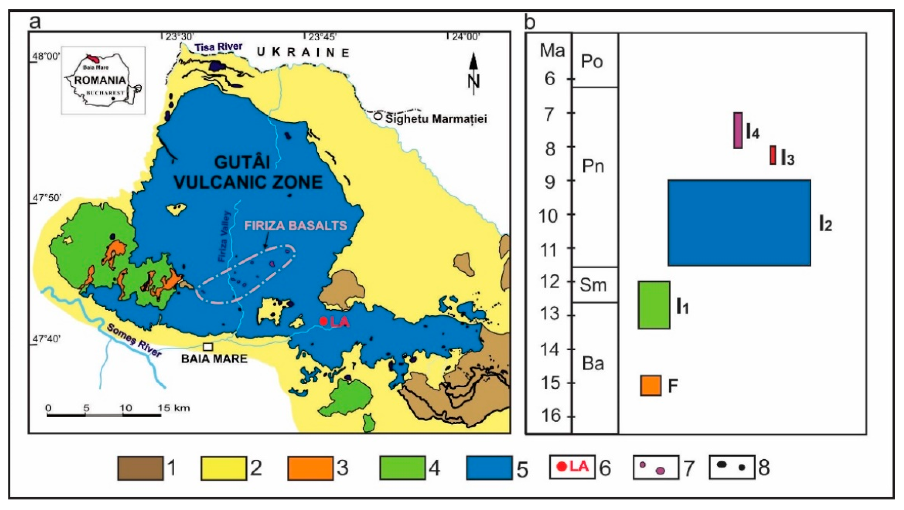
The Gutâi Volcanic Zone (GVZ) belongs to the Neogene–Quaternary volcanic range of the East Carpathians in the northwestern part of Romania. This volcanic range was built up during the Cenozoic geotectonic evolution of the broader Carpathian–Pannonian region (Figure 1 and Figure 2), where the Miocene volcanic activity took place between 15.4 and 7.0 Ma [22]. The region is well known for its richness in precious and polymetallic ore deposits mined along centuries-long intervals.
The geological structure of the GVZ is composed of three major units: pre-Neogene basement (Precambrian to Paleozoic metamorphic formations, and Paleogene flysch deposits), Neogene (Badenian, Sarmatian and Pannonian) sedimentary deposits and Neogene volcanic formations [25] (Figure 2a).
Volcanic activity evolved in the Gutâi Volcanic Zone [25] in two major stages:
  • Early felsic (i.e., rhyolitic), caldera-related explosive volcanism, starting at 15.4 Ma [26], fully correlated with the formation of the rhyolitic Dej Tuff Complex of the same age in the neighboring Transylvanian Basin and partially correlated with the widespread rhyolitic volcanism in the Pannonian Basin. Its products (ignimbrites and their resedimented counterparts) occur in the southwestern part of the GVZ (Figure 2a).
  • Intermediate (mostly andesitic) volcanism developed in the 13.4–7.0 Ma time interval [25] when a variety of volcanic rocks, ranging from basalts to rhyolites, were emplaced in the entire area of the GVZ. This volcanic activity, reaching its climax between 11 and 9 Ma, comprised four phases [27]: (1) between 13.4 and 12.1 Ma, generating andesitic shield volcanoes, lava flows and extrusive domes in the southeastern and southwestern part of the GVZ (Figure 2a); (2) paroxysmal activity between 11.6 and 9.0 Ma, producing predominantly medium-K basaltic andesites, andesites and dacites constructing the most voluminous volcanic structures in the central and northern parts of the area (Mogoşa and Igniş composite volcanoes), the large-sized Gutâi and Pleşca Mare extrusive domes and extended lava plateaus (Figure 2a), while shallow subvolcanic intrusions (dykes, sills, small-sized laccoliths) dated between 11.8 and 9.0 Ma occur mainly in the southeastern part of the volcanic area; (3) a small-sized composite andesite–dacite intrusive structure, the Laleaua Albă magmatic complex (8.5–8.0 Ma, located in the central–southern part of the volcanic area, represents the third volcanic stage (Figure 2a); and (4) the fourth volcanic stage, consisting of several small-sized intrusive bodies of olivine-bearing basalts (the Firiza basaltic complex, 8.1–7.0 Ma [28]), developed in the central part of the GVZ (Figure 2a).
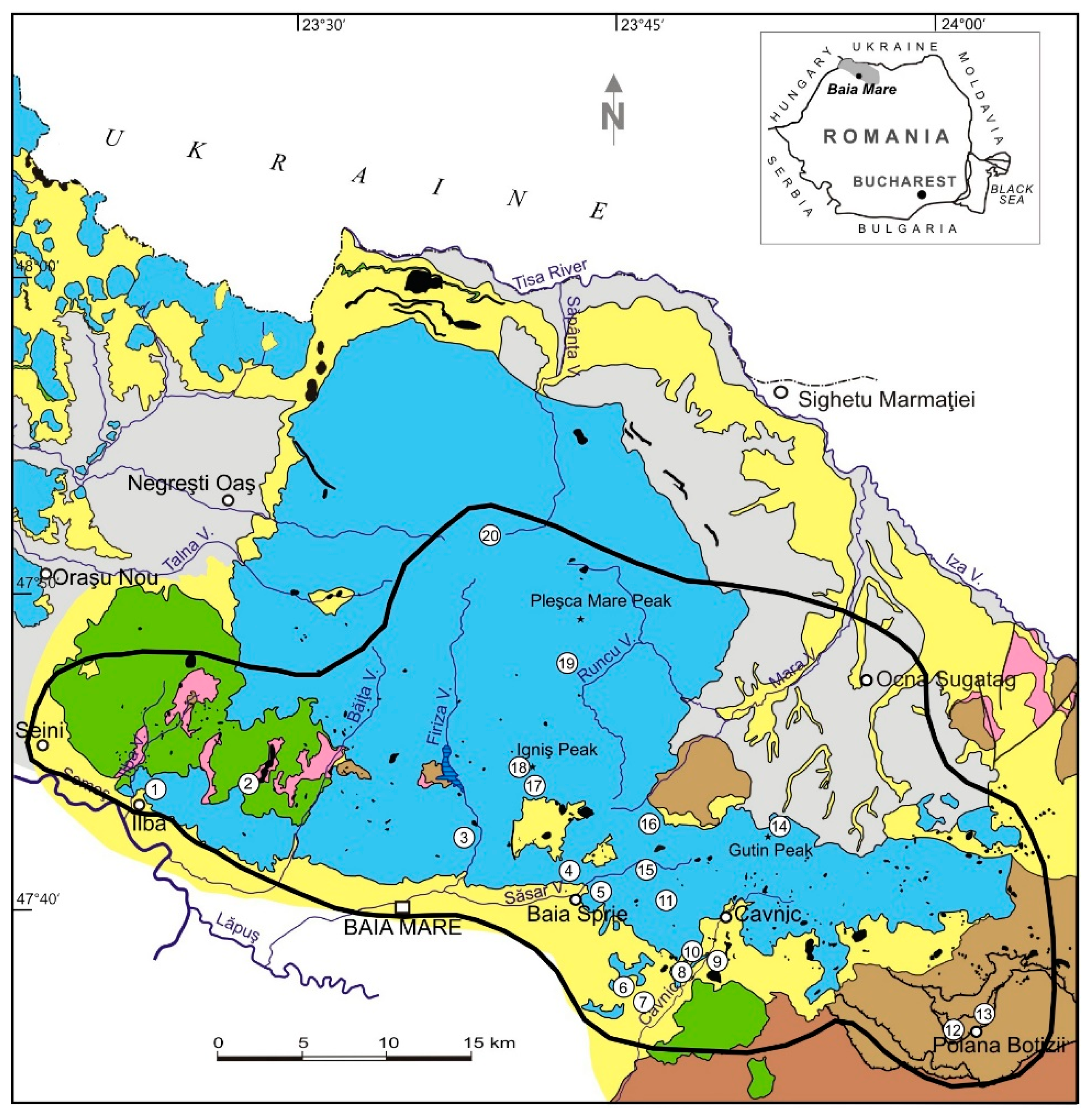
Ore-forming hydrothermal activity dated at 11.5–7.9 Ma [29] developed in connection with the intermediate-composition magmatism in the GVZ represented by epithermal polymetallic and gold-rich veins genetically related to the intrusive magmatism. These ore deposits occur in the southern part of the GVZ, from Ilba in the west to Poiana Botizei in the east, with the most important of them being Săsar and Dealul Crucii (in the neighborhood of Baia Mare city), Baia Sprie and Cavnic (Figure 3).

2. Materials and Methods

In order to present the main patrimonial values in the area of the future geopark, both bibliographic documentation and field-based studies were undertaken. First, we performed extensive literature research related to the topic “Geoparks as a Form of Tourism Space Management”, including theoretical considerations regarding the concepts of geoheritage, geopark, geoeducation and geotourism. Since we are considering the establishment of a future geopark in accordance with the regulations regarding the accreditation of a geopark, we considered the study of the geological heritage as a major task, placing it at the very core of our endeavor. As such, we performed field studies in the whole volcanic region included in the future geopark by inventorying all the sites of geological interest (SGIs). In addition, comparative studies were also undertaken with other areas in the Carpathian volcanic range to highlight their uniqueness. Field studies have also been conducted regarding the mining heritage sites and natural protected areas. All the visited sites of geological interest (SGIs) and mining heritage sites were documented using the available literature data, in situ observations and photographs. In the case of cultural heritage, besides the literature research, we searched supplementary documentation in state archives and in cultural institutions (e.g., museums), complete with official sources of domestic institutions (e.g., the “List of the historical monuments of Maramureș County” [30,31]).
Our present study also benefits from the published results of previous research by the authors in which quantitative evaluations of in situ and ex-situ geosites—based on the methodology proposed by Brilha, 2016 [10]—and their objective hierarchical classification were obtained [21,32,33]. These results are integrated here in the framework of the geopark concept, with special emphasis on sustainable tourism. Some of the geosites from the area of the proposed geopark have also been briefly described in a previous paper published by Szakács and Kovacs in the Land Special Issue, “Geoparks, Geotrails, and Geotourism—Linking Geology, Geoheritage, and Geoeducation” [20].
To develop a research methodology in order to define the territory, its heritage and development objectives that align with local needs and international criteria for the future “Gutâi-Maramureș” UNESCO Geopark, besides the aforementioned tools and methods, public and professional meetings, stakeholder consultations, and comparative analyses with other geoparks have been used.

3. Results

Resulting from our recent follow-up research in order to identify the heritage values supporting the establishment of a UNESCO geopark and sustainable tourism in the Gutâi Volcanic Zone, below we present the most important patrimonial assets, including geological, mining, natural and cultural heritage.

3.1. Geological Heritage

In the area of the proposed “Gutâi-Maramureș” Geopark, characterized by geological complexity, there are numerous geological sites (i.e., geosites) with high scientific, educational and touristic value [21]. They are predominantly located in areas dominated by volcanic rocks (Figure 3). These geosites are related to volcanic structures and their products, to tectonic structures, as well as to minerals and fossils.
The most significant geological patrimonial value is represented by the mineralogical heritage. Besides the numerous mineral species identified in the igneous rocks, those related to the hydrothermal ore deposits are by far the best represented (ca. 150 mineral species were described in the area, more than 90 only in the Baia Sprie ore deposit [34]). The ore-related mineral assemblages consist of native elements (gold, silver, copper, arsenic, sulfur), sulfides, sulfosalts, iron oxides and hydroxides, wolframite, silica (quartz and chalcedony), K-feldspar (adularia), clay minerals, carbonates and sulphates. Ten of these minerals were described for the first time in the world: felsőbányaite [35], dietrichite [36], szmikite [37], semseyite [38], senandorite [39,40] and klebelsbergite [41] in the Baia Sprie ore deposit, rhodochrosite [42] in the Cavnic ore deposit, fizélyite [43] in the Herja ore deposit from Chiuzbaia, fülöppite [44] in the Dealul Crucii ore deposit, and most recently, baiamareite in the Săsar ore deposit [45] from Baia Mare.
In their recent paper, Gál et al. [32] have realized a complete inventory of the 16 mineral type localities (the localities where minerals have originally been described) in Romania. In these type localities, thirty-nine mineral species and one chemical element were described and named for the first time in the world. Four mineral type localities were first found within the area of the proposed “Gutâi-Maramureș” Geopark: Baia Sprie (six minerals), Baia Mare (two minerals from the Dealul Crucii and Săsar ore deposits), Cavnic (one mineral) and Chiuzbaia (one mineral). With six new mineral species discovered, the mineral type locality Baia Sprie is the second richest in Romania. Based on the quantitative assessment of their scientific, educational and touristic values (according to Brilha [10]), the mineral type localities in Romania were hierarchically classified, with Baia Sprie being the highest ranked [32]. All these type locality spots might be considered as geosites with intrinsic geoheritage relevance due to their unique and unrepeatable character.
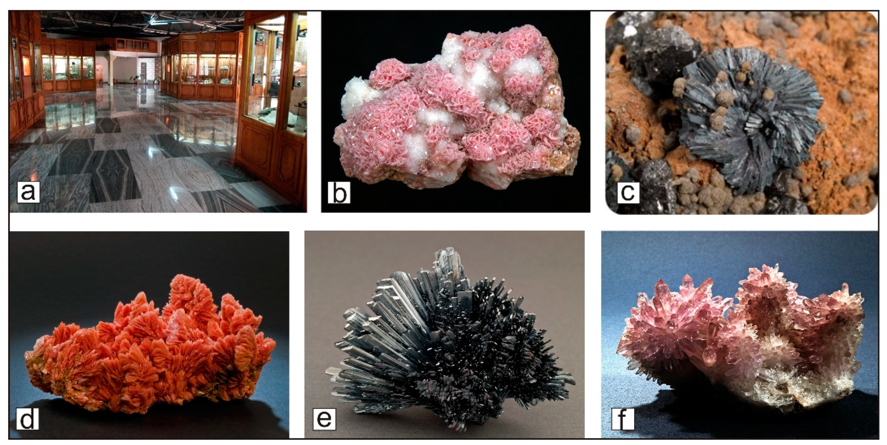
Baia Mare city, the administrative and cultural center of Maramureș county, hosts an important ex-situ type geoheritage site where almost all the known minerals inventoried in the mentioned ore deposits are found and exposed—the “Victor Gorduza” County Museum of Mineralogy (Figure 4). It is one of the largest geological museums in Romania, and one of the most important regional mineralogical museums in Europe. Its uniqueness is due to the fact that almost its entire mineral collection originates from the well-known Baia Mare mining district found within the proposed “Gutâi-Maramureș” Geopark. The mineral collection (16,689 pieces) includes those ten minerals described for the first time in the world in the Baia Mare mining region [33].
Among the most spectacular, aesthetically outstanding, and rare mineral specimens are to be mentioned the acicular/prismatic stibnite crystals, the differently colored tabular barite, the black-and-white calcite spheres, the large-sized and perfectly transparent gypsum, the reddish prismatic realgar, the perfect shapes of vivianite and many minerals with zoomorphic shapes [33] (Figure 4 shows a selection of them). The quantitative assessment (acc. to Brilha [10]) of the Mineralogical Museum as an ex-situ geosite reveals its high scientific (380/400), educational (390/400) and touristic attraction (380/400) potential [33]. It will play a key role in the geotourism development of the proposed “Gutâi-Maramureș” Geopark.
Among the many fossil-bearing geosites of the area, the most representative is the Chiuzbaia paleontological reserve with official protection status (IV IUCN). It is a fossil flora type locality, where some of its palaeobotanical species were described for the first time in the world [46]. It is unique in Romania and well known in Europe due to its impressive Upper Miocene fossil flora being the most representative of the eastern part of the Paratethys, at least equally important as the palaeoflora of Oehningen and Willershausen (Germany), considered a benchmark in terms of richness and variety [46]. The first mentioned related to the Chiuzbaia fossil flora date back to the year 1860 [47]. Two monographs on the fossil flora of Chiuzbaia were published in 1990 [46] and 2023 [47], respectively. A total of 140 taxa, of which 30 were new, were inventoried and presented in the most recent monograph.
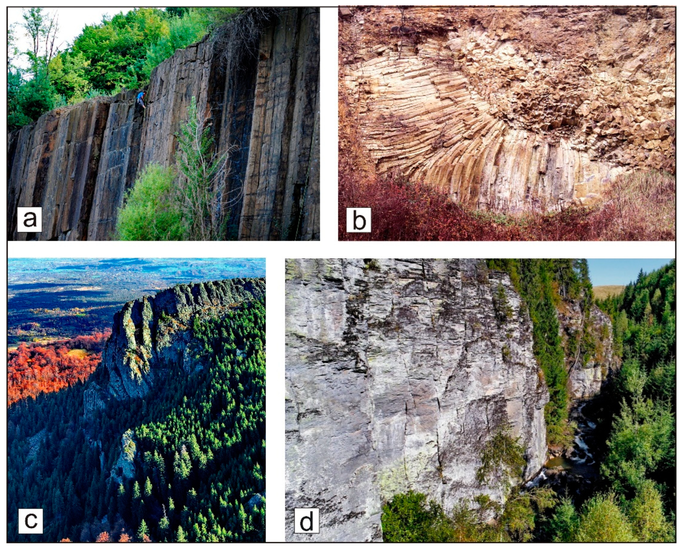
Numerous geological sites in the proposed “Gutâi-Maramureș” Geopark are related to volcanic areas. They are of the petrological, mineralogical, stratigraphic, paleontological, structural, geomorphological and hydrogeological types according to Brilha’s [10] classification. Some of the geosites have official protection status at the national level: Limpedea Pillars (III IUCN, 3 in Figure 3), Ilba “Stone Rosette” (III IUCN, 1 in Figure 3), Creasta Cocoșului/Rooster’s Crest (IV IUCN, 14 in Figure 3), Tătaru Gorges (IV IUCN, 19 in Figure 3), Blue Lake (III IUCN, 4 in Figure 3) and Chiuzbaia fossiliferous reserve (IV IUCN, 17 in Figure 3). All these geosites have been briefly described by Szakács and Kovacs [20]. The “Limpedea Pillars” geosite is located in the neighborhood of Baia Mare city, representing spectacular vertical columnar-jointing of andesite in an old quarry, a touristic attraction and a traditional rock-climbing site (Figure 5a).
The Ilba “Stone Rosette” is an outcrop of a radial columnar-jointed sub-aqueously emplaced extrusive andesite dome (Figure 5b). The “Rooster’s Crest” represents an impressive residual landform of erosional origin occurring at the northwestern edge of the large-sized (ca. 5 km across) subaerially emplaced Gutâi andesitic extrusive dome (Figure 5c). It is a major touristic attraction site included in a very popular geotrail. The “Tătaru Gorges” geosite is located in the central–northern part of the Gutâi Mts., dug in the extensive andesitic lava plateau, representing one and the bigger of the two gorges in Romania excavated in massive andesitic lava flows (Figure 5d). It is also a touristic attraction site. The “Blue Lake” is a hydrogeological type geosite located at the Mine Hill in Baia Sprie town. It is a mining-related anthropic lake with changing blue–greenish-colored water imprinted by ore minerals, unique in Europe. Due to their outstanding and spectacular features, all the geosites with official protection status found in the proposed “Gutâi-Maramureș” Geopark, excepting the Limpedea Pillars, are unique not only in Romania but in the whole East Carpathians volcanic range.
Numerous other geosites in the proposed geopark area, with no current official protection status, are also of significant geoheritage value. They are presented in Table 1 and some of them are shown in Figure 6. They belong to several types of Brilha’s classification: petrological, mineralogical and geomorphological (the “White Tulipe” composite dyke), stratigraphic and structural (Senonian red marls at Poiana Botizei). Their uniqueness at the international, national and regional levels determines their high scientific value. The “White Tulipe” composite dyke (Figure 6c,d) is unique in the East Carpathians volcanic range, whereas the outcrop of the Poiana Botizei “Pienniny Klippen” formation is the only such occurrence in Romania.
Many of the mentioned geosites are touristic attractions and traditional rock-climbing sites (e.g., the “Limpedea Pillars”, the “Rooster’s Crest” and “Vlaicu’s Church” of the “White Tulipe” magmatic complex) and/or have been included in scientific and educational field trips (the Ilba “Stone Rosette”, the “White Tulipe” composite dykes, the Chiuzbaia fossiliferous reserve, the Blue Lake, and the Top of the Igniș volcano).
Based on Brilha’s methodology [10], Kovacs et al. [21] presented the results of the quantitative assessment of fifteen out of the twenty described geological sites. Most of them have scientific values (SV) greater than 300 (out of a total of 400) and similar ranges of potential educational use (PEU) and of potential touristic use (PTU): 210–310 (the majority with values > 250). Based on these data and in accordance with Brilha’s [10] suggestions, the geosites could be included in field trips of scientific or public interest, or in geotrails, as well as being promoted as tourist destinations at the regional, national and international levels.

3.2. Mining Heritage

The rich ore deposits of precious metals in the southern part of the Gutâi Volcanic Zone were sources of great attraction, resulting in their exploitation starting many centuries ago. The first written documents attesting to the cities of Baia Mare and Baia Sprie from the beginning of the 14th century referred to the development of mining activities and to the rights of the miners. Mining in the area of the would-be geopark continued uninterrupted for about 700 years until 2006; therefore, there are numerous vestiges and heritage sites linked to the older and newer mines.
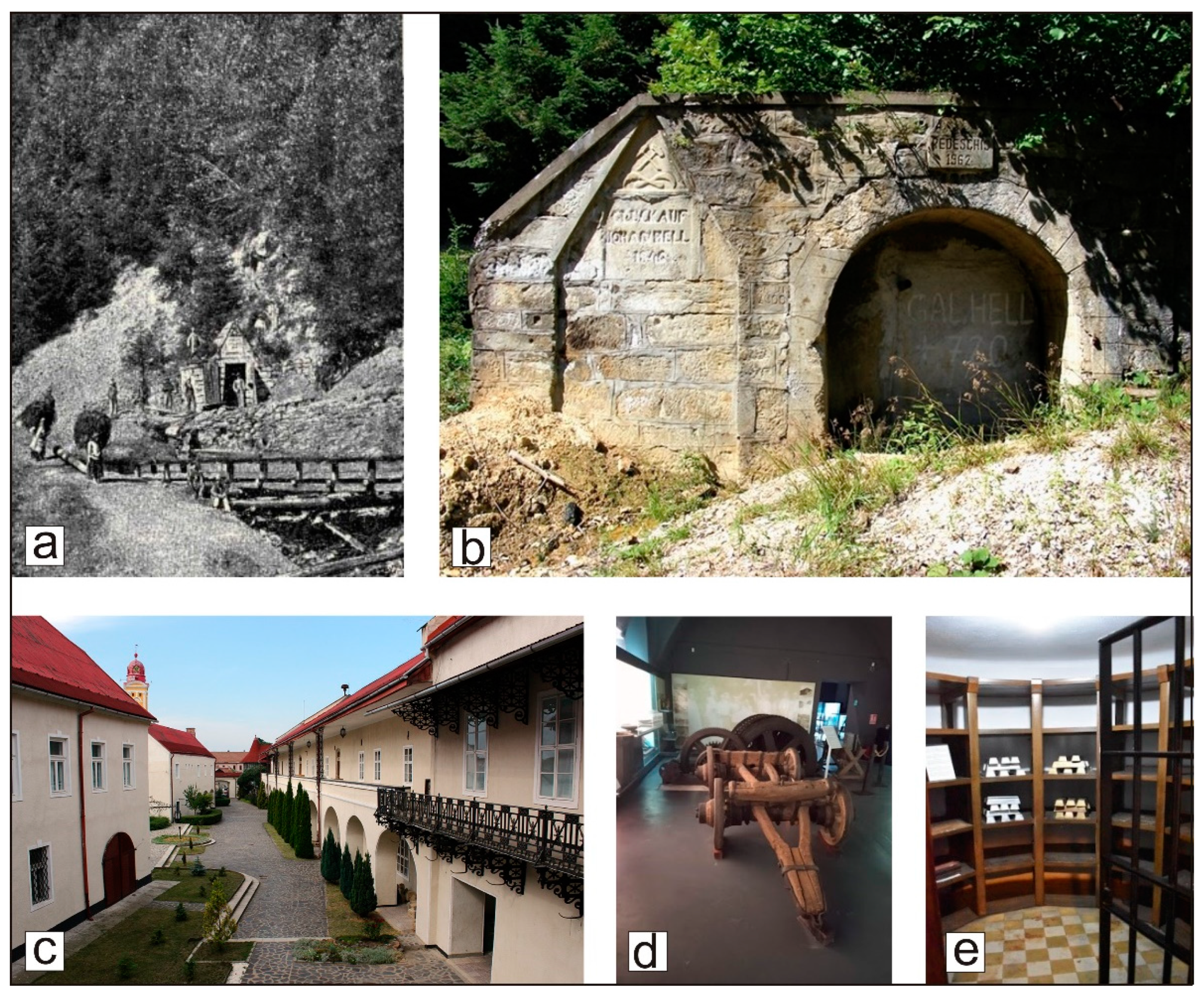
Among the most important mining sites are those in the Baia Sprie, Baia Mare, Cavnic and Băiuț localities. The Baia Sprie epithermal ore deposit represents one of the best-known ore deposits in Romania and Europe. The ore deposit had been mined continuously since the beginning of the 14th century, when it was mentioned for the first time in written documents as Mons Medius (Dealul Minei/Mine Hill [48]). The mine was closed at the end of 2006, together with all the mines in the Baia Mare mining region. With its more than 5 km extension, the “Main Vein” was one of the longest hydrothermal veins in Europe [48], first exploited in the Mine Hill (Figure 7a).
After 7 centuries of mining activity, both underground and in an open pit (Figure 7c), the Mine Hill represents a unique geological and mining heritage site with numerous remnants related to mining activities—galleries, shafts, excavations and waste dumps, which can be partially visited today. The six minerals described for the first time in the world from the Baia Sprie ore deposit are from the Mine Hill mining works. The picturesque Blue Lake is located on the southern slope of the Mine Hill, being formed in the years 1919–1920 as a surface depression generated above an underground vein excavation.
Baia Mare city hosts one of the oldest mining activities known in the region. A document from 1327 of the Hungarian King Charles Robert I of Anjou mentioned the settlement of Zazarbánya (Săsar mine) located in the northwestern part of Baia Mare city. In another document from 1347 of the Hungarian King Louis I of Anjou, the right of the town to organize mining activities was confirmed [49]. The Săsar mine was more or less continuously exploiting gold–silver ore until 2006. About 700 years after the first mention of mining in Baia Mare, a new mineral species was recently described for the first time in the world from the Săsar mine (2023, [45]). It was named after the name of the city—baiamareite—and approved as a new mineral species by the Commission on New Minerals, Nomenclature and Classification of the International Mineralogical Association (IMA). A specimen of this newly discovered mineral is shown in the Baia Mare Mineralogical Museum.
Important remnants of the mining activity during the Middle Age are found in Dealul Crucii (Cross Hill), in the northern part of Baia Mare, where a gold–silver ore deposit had been exploited until 2006. Besides the oldest preserved underground galleries in the region, several old surface excavations and shafts that followed the main vein of the ore deposit can also be seen. Among them, it is worth mentioning the “Smoke gallery” as testimony to the medieval “fire exploitation” method [50]. The entrance of the Lobkovitz (Heilige Kreuz) gallery, excavated at the base horizon of the Dealul Crucii mine in the year 1765, is located in the historic center of the city. An additional construction of mining-related activity in Dealu Crucii is the channel serving as an aqueduct, known as the Thurzó channel, built between 1505 and 1515 in order to supply water for the pumps used to remove mine waters from the lower levels of the mine [51]. Part of the ca. 16 km of the original channel (including several tunnel segments) can be visited following the recent exploration work undertaken by speleologists from the Montana Club in Baia Mare. The new mineral fülöppite from the Dealul Crucii mining works was described nearly a century ago (1929, [44]).
One of the most important mints in Transylvania, as well as in Hungary, and later in the whole Austrian–Hungarian Empire, has been operating since the beginning of the 14th century in Baia Mare. Since 1748, the mint functioned in the building of what is today the Historical and Archaeological Museum.
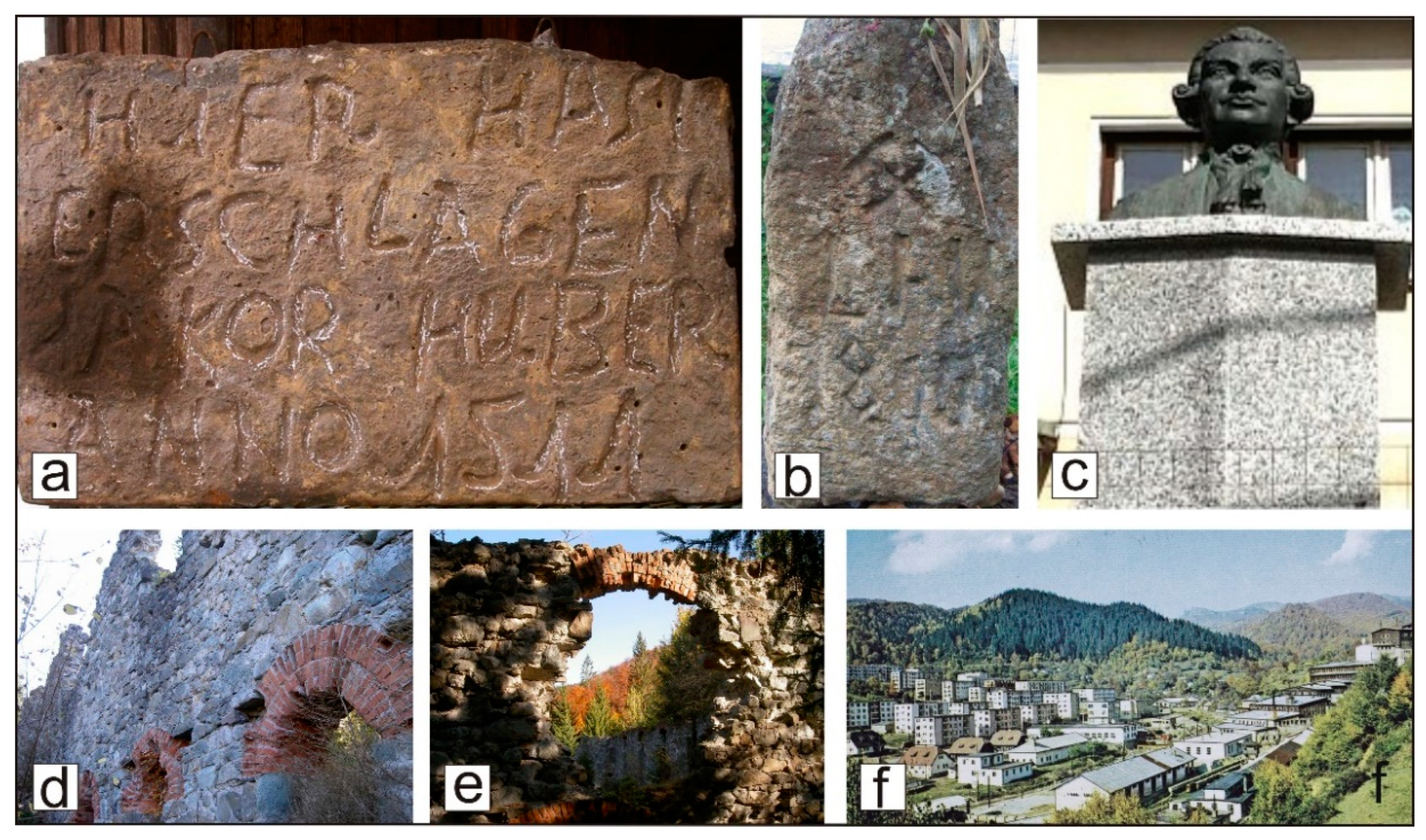
Mining starting from the Middle Ages is also known in Cavnic town, although not as old as in Baia Mare and Baia Sprie. A number of old artifacts testify not only to the existence of mining activity in the 16th century but also to the presence of German miners in Cavnic (Figure 8a).
An old building, the “Arenda house” with the inscription “Anno 1717—mio cult”, located in the old part of the town hosted the headquarters of the Cavnic Mining Office between 1749 and 1859, and later, the Cavnic Mining Court established in 1761. Another historical monument building from the 18th century, which for a long time was the headquarters of the Cavnic mine, is the “Born and Papp Museum”. It worth mentioning that the world-renowned mineralogist and mining scientist Ignac von Born (1742–1791), a honorary member of the Academies of Vienna, London, Munich, Padua, Berlin and Stockholm, had visited and worked in the Cavnic mine (Figure 8c). Papp Simon (1886–1970) was a world authority in petroleum geology and was born in Cavnic town. In front of the old mining work of the “Reiner gallery/Erbstollen” (started in 1644 under the name “Odon”, resumed working in 1753 under the name “Iosif gallery” and renamed “Reiner gallery” in 1810), there is a recent monument in memory of the political prisoners who worked in the Cavnic mine in the years 1951–1955 of the Romanian communist period. Another mining-related historical building, “Logolda”, actually the ruins of the first gold refinery plant using cyanide in Europe, built in 1899 (Figure 8d,e), is located in the upstream part of Cavnic town.
Băiuț village developed around the mine, which extracted gold from the early Middle Ages. In the 17th century, miners brought from Moravia, Silesia, and Galicia worked in Băiuț. The excavations of the “Divine Providence” vein and some galleries are the old remnants of the Băiuț mining activity (Figure 9a,b).
An important ex-situ mining heritage site is the County Museum of History and Archaeology in Baia Mare with its mining section (Figure 9c), which reflects the history of the mining activity within the area of the proposed geopark. Excavation tools, ore transport equipment and shaft machinery, underground lighting equipment, documents and photographs are displayed in the mining history collection, many of which are unique (Figure 9d). There also are components kept in situ from the first refining facility in Romania, which operated in this space from 1926 to 1967, including the treasury, the precinct where the gold and silver bars were kept before transferring them to the National Bank of Romania (Figure 9e).

3.3. Natural Heritage

The natural heritage sites in the proposed geopark area are diverse and consist of habitats of high biodiversity and of ecological importance, and they host a large number of flora and fauna species. The diversity of the ecosystems and habitat types is strongly related to the various geomorphological features of the area.
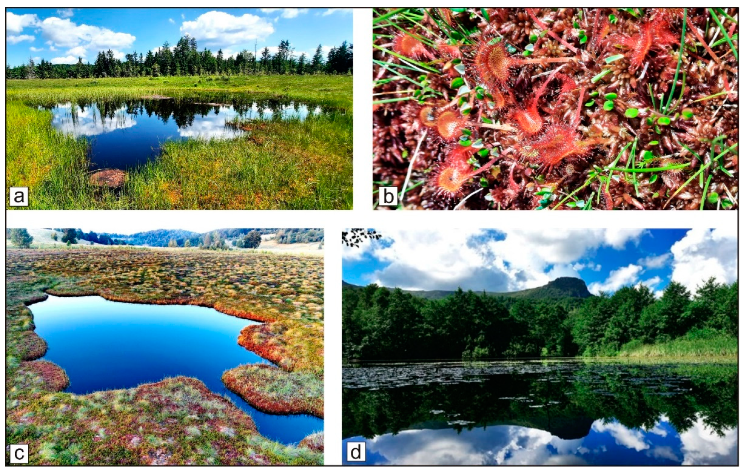
Within the area of the potential “Gutâi-Maramureș” UNESCO Global Geopark, twenty-one sites have been attested to as natural protected areas at the national level and two at the local level, with the geosites presented earlier being among them [54]. The natural protected areas, other than geological, recognized at the national level are of the botanical–wetland, mixed, speleological and forestry types (III and IV IUCN, Table 2, Figure 10).
In the area of the proposed geopark, six European Natura 2000 sites are designated (four of SCI, one of the SPA-type and one of the mixed-type [54]). One of the sites preserves representative areas of virgin forest in the Carpathians (secular forest in Strâmbu-Băiuț) and was designated as a UNESCO World Heritage site.
In the proposed geopark area, the fauna species of community conservation interest include birds (peregrine falcon, mountain eagle, black woodpecker), reptile species (vipers, snakes), and mammals (wolves, bears, wild boars, lynx, deer, ermine, etc.).

3.4. Cultural Heritage

The cultural heritage in the area of the proposed geopark is extremely diverse, including elements of tangible and intangible patrimony. In accordance with the Romanian legislation, the historical monuments within the proposed geopark area are classified into two categories: Category A, which includes monuments of national and international significance, and Category B, which encompasses representative monuments of local cultural heritage. Notably, five of the Category A monuments in the area are listed as UNESCO World Heritage Sites. A total of 172 historical–archaeological monuments representing the two categories are found within the proposed geopark territory, 47 of which are Category A [30]. Only the monuments of this last category are discussed in this paper. Some of the most representative monuments are presented in Table 3 and Table 4 (data in the tables are from [30,31,49,55]).
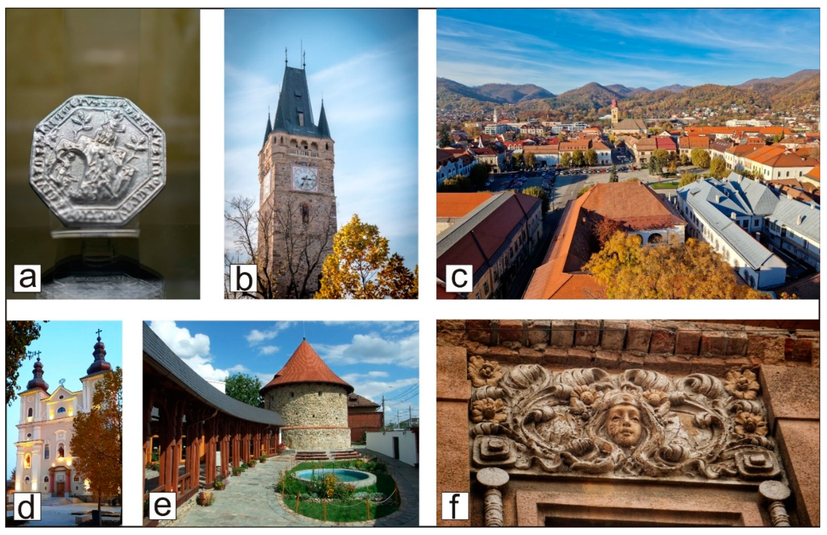
Most of the historical monuments are located in Baia Mare city, first mentioned in an official document from 1329 with the name “civitas Rivuli Dominarum” (the town of the Ladies’ River [49]). Some of them are depicted in Figure 11.
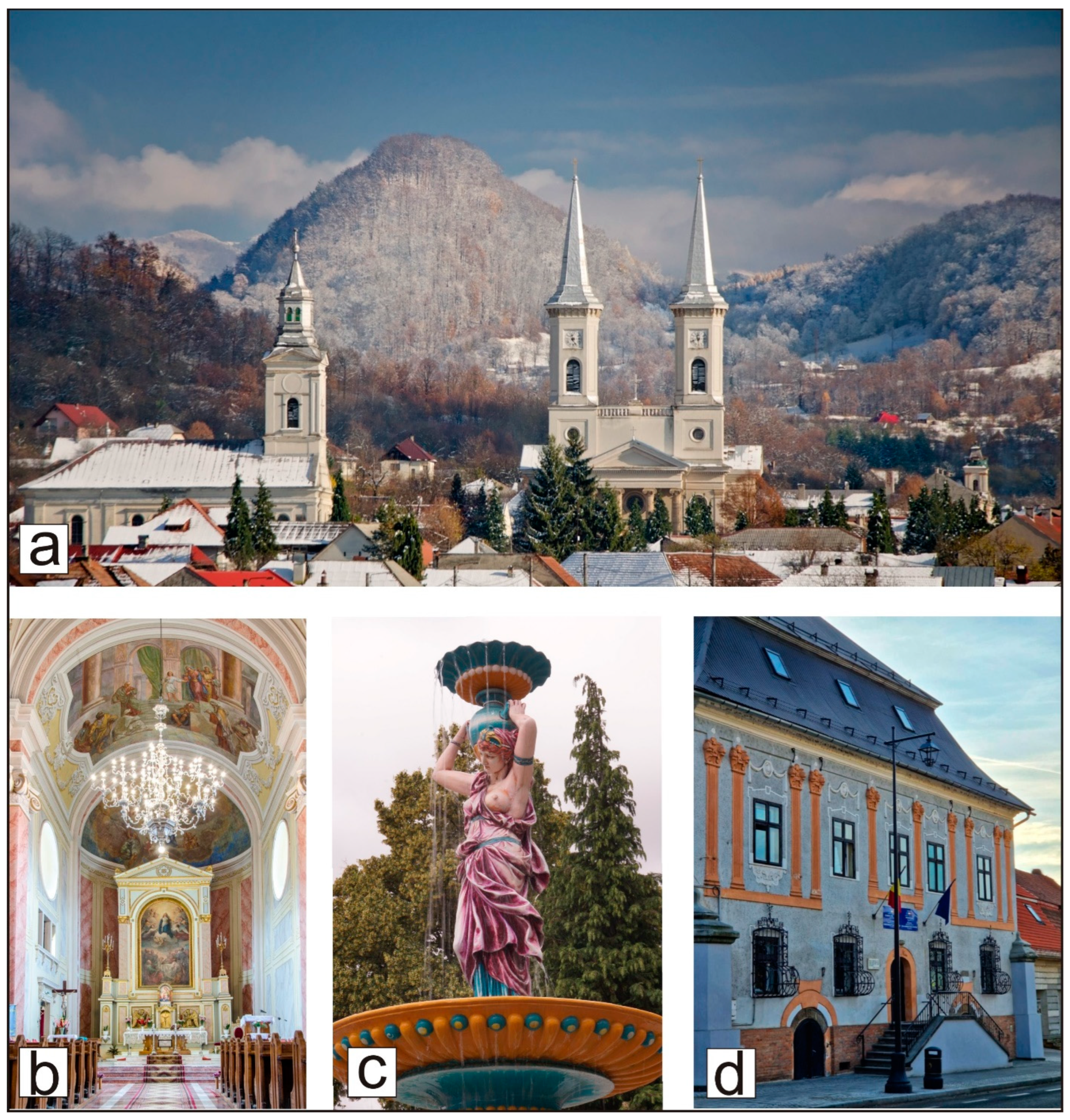
Many of the original monuments have been modified over the centuries after their destruction during wars or fires. Some original building elements have been preserved and can be recognized due to the architectural style from the time they were build (Figure 12).
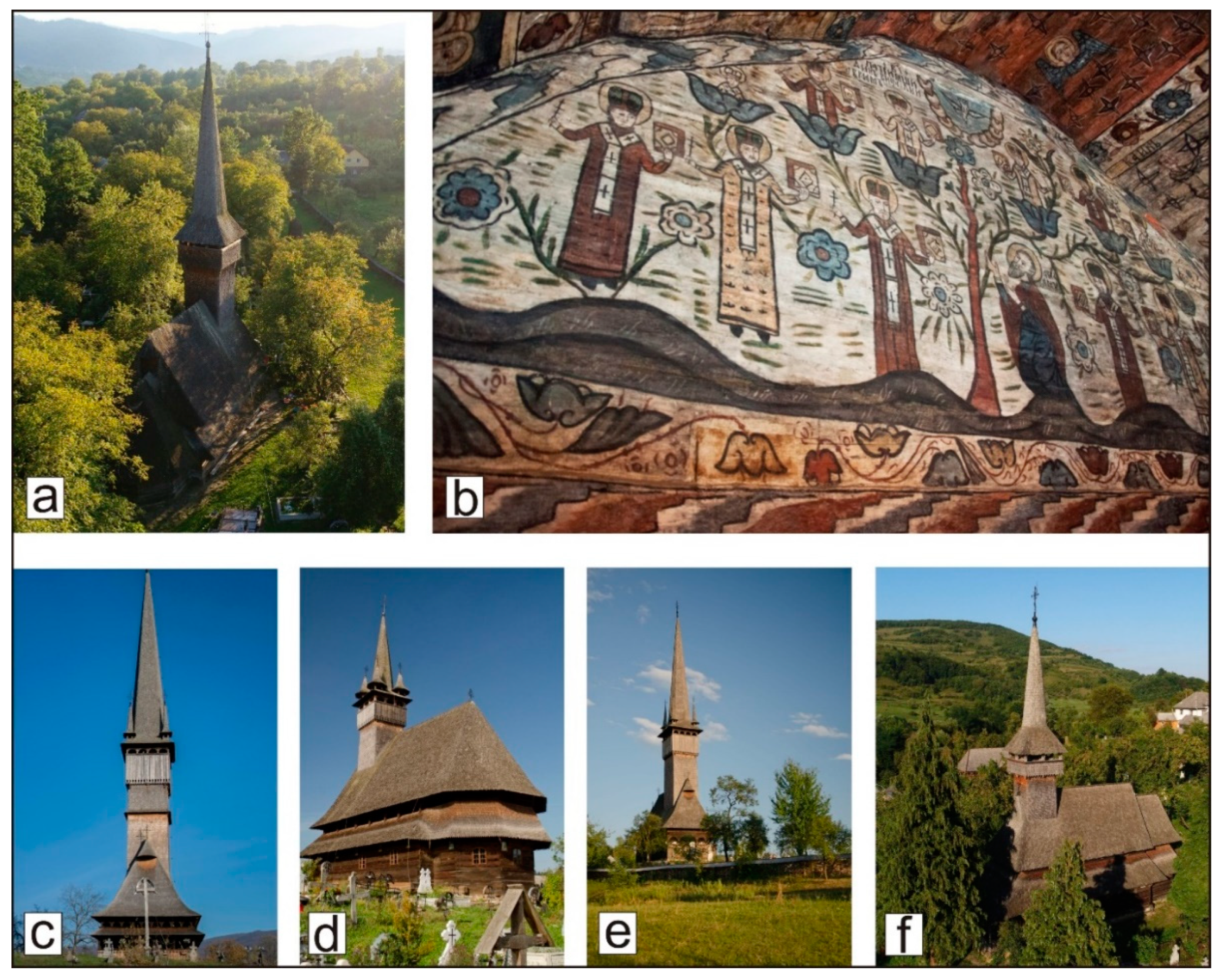
The most important monuments of cultural heritage are represented by those included in the UNESCO World Heritage List (Table 4 and Figure 13). There are five wooden churches in this prestigious list, located in Budești, Desești, Plopiș, Poienile Izei and Șurdești villages [31].
Besides the five wooden churches included in the UNESCO World Heritage List, in the area of the future geopark, there are many others old wooden churches (16–18th centuries) classified in Category A (e.g., Botiza, Breb, Sârbi, Hoteni villages). The five UNESCO wooden churches are the most representative from the architectural point of view and based on the interior paintings (Figure 13).
Another part of the tangible cultural heritage in the proposed geopark is represented by the collections of the museums within the area. Four important museums hosting collections of outstanding patrimonial value are found in Baia Mare city: the “Victor Gorduza” County Mineralogical Museum as an ex-situ geoheritage site, and the Mining section of the County Museum of History and Archaeology as an ex-situ mining heritage site.
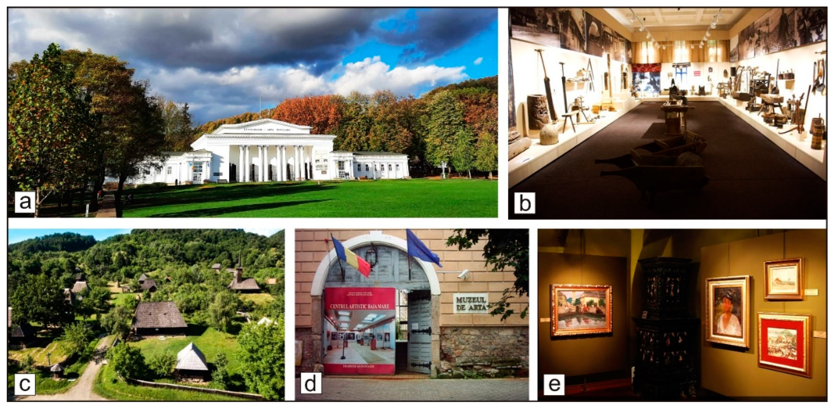
The County Museum of Ethnography and Folk Art (Figure 14a) hosts exhibitions that reflect the occupations, crafts, and traditional costumes of the region (Figure 14b). The outdoor section is represented by the Village Museum, an exciting and beautiful open-air museum with numerous very old houses and households representative of different ethnographic regions of Maramureș county, and an old wooden church (Figure 14c).
One of the most significant museums in Baia Mare is the County Museum of Art, located in an old building (built in 1748) in the historic center of the city (Figure 14d). Unique at the national level due to the character of its collections, the museum highlights the activity of the world-famous Baia Mare Artistic Center, founded in 1896. Its prestigious art collection includes over 300 works by artists who exclusively created in the renowned “Baia Mare Colony of Painting” from 1896 until the present day [57] (Figure 14e).
In addition to the tangible cultural heritage, a very rich intangible cultural heritage is also well known at the national and international levels in the area of the proposed geopark. It consists of a great variety of old habits, customs, activities and celebrations in the rural communities. The wooden gates, crosses and wayside crosses (serving as both religious and community markers), and many carved objects are famous and represent important tourist attractions. Other old crafts—pottery, wool weaving, icon painting—are found in many of the villages in the area. The well-preserved traditions of the communities concerning Christian holidays and agricultural ceremonies, widespread within the entire territory, complete the intangible cultural heritage of the future geopark.

4. Discussion

Starting a geopark project requires a structured research methodology to assess the area’s geodiversity, biodiversity, and cultural significance while aligning with the UNESCO Global Geopark (UGGp) criteria. In our approach, we are considering the geopark as a complex, interconnected system of natural, cultural, and geological elements that sustain the identity, function, and resilience of a landscape, including local communities. The geopark project aims not only to reveal system connections but also to repair the “tissue” of a landscape, meaning all the tangible and intangible connections among the earth, nature and people developed during the centuries. The scientific research methods focus on understanding, restoring, and sustaining this interconnected system.
The Baia Mare region, as part of the future “Gutâi-Maramureș” Geopark, is a historically significant mining region in Romania, having a complex geological, biological, and cultural landscape. Historical and recent industrial activities have left socio-economic challenges, including landscape degradation, cultural deterioration and a huge mining heritage to be integrated into further development and to contribute to strengthening the local identity, and the geopark could play a key role in this. Our research serves as a foundation for the geopark project development and implementation of the first steps to be taken so far. This methodology ensures that the geopark project aligns with international standards and maximizes the benefits for community involvement and support, geoeducation and sustainable tourism initiatives.
The basic requirement for a global geopark, as stated in the UNESCO Program [58], is “to be a single, unified geographical area where sites and landscapes of international geological significance are managed with a holistic concept of protection, education and sustainable development”. A geopark has to take into consideration all local values, not only its geodiversity, and to identify the interconnections between geodiversity, biodiversity and human activities using a multi-disciplinary approach. The bottom-up development of a geopark project, which includes communities, associations, local administrations, museums and other resources, needs to be supported by research partnerships and the geopark’s professional involvement.
Our approach was to develop a research methodology in order to define the territory, its heritage and development objectives that align with local needs and international criteria. The established research activities and results were planned to address to the following research questions. (1) What are the geological, including the mining heritage, natural and cultural values of the future geopark? (2) Does the territory fulfill the requirements of a UNESCO Global Geopark and an international brand? (3) Could pilot education and sustainable tourism initiatives test, refine, and demonstrate the potential of the geopark before full-scale implementation? Based on these requirements and the local context, our research methodology was planned to answer to the main research questions and to engage communities, engaging local support attract visitors, securing funding, and ensuring long-term sustainability. All the activities could be integrated in five research objectives. (1) To realize a synthesis of geology of the area as abiotic values (A) and identify and basically asses the geological heritage (GH) in order to make it geology understandable for local communities and valuable to be used in education, tourism and visiting infrastructure development. (2) To realize a synthesis of local biodiversity, especially basic flora, fauna, habitats and protected areas as biotic values (B) and the valuable natural heritage (NH). (3) To document cultural values, including historical and archaeological significance of mining heritage as cultural values (C) comprising tangible and intangible heritage as part of the cultural heritage (CH). (4) To conduct two SWOT analyses, one for the broad territory considered to become a geopark and another one for the geopark project. Conducting SWOT analyses for both the “Gutâi-Maramureș” area and the “Gutâi- Maramureș” Geopark project is crucial to help us in our next project steps: define the optimal geopark territory and partner mayoralties and establish the core values for a strong brand identity. These analyses help ensure that the geopark’s boundaries maximize its strengths while addressing potential risks, all while shaping a marketable image that attracts visitors, funding, and local support. (5) To develop education and sustainable tourism pilot activities in the “Gutâi-Maramureș” Geopark activities, aiming to ensure the geopark’s awareness and community engagement. A synthesis and a brief description of each of the five can be found in the Table 5.
The research objectives aimed to demonstrate how scientific research, combined with community involvement and sustainable practices, can offer long-term benefits to the region. The integrated inventory and assessment is bringing clear evidence of the feasibility of the UNESCO Global Geopark Project, presenting clear evidence of the geopark’s potential to drive economic growth, education, and sustainable tourism and strong data for local administrations to support and invest in the project. A SWOT analysis for the “Gutâi-Maramureș” UNESCO Global Geopark Project is shown in Table 6.
Previous studies dedicated to the possibility of a geopark project in the Baia Mare area emphasized the unique geological, cultural and natural heritage, and especially, the long and storied history deeply connected to mining [18].
The geological and mining heritage is the core concept of the geopark project and it offers a solid foundation for a sustainable planning endeavor that integrates geology, environmental, social, and economic considerations to ensure long-term viability and positive impact. Identification and use of the heritage values as a basis for educational (geoeducation) activities and sustainable tourism (geotourism) was a strategic decision in order to better promote and support the geopark idea. The territory holds immense potential for geoeducation and tourism due to its unique combination of geological, natural, mining and cultural heritage. By integrating local communities into these initiatives, the geopark can start to play its role to develop its own calendar of events and innovate in terms of both education and tourism.
The two main pathways identified for the development of sustainable tourism by harnessing all the patrimonial values in the potential “Gutâi-Maramureș” UNESCO Global Geopark are (1) geoeducation and (2) geotourism.
(1) The implementation of the geoeducation concept at the community level, including through the promotion of educational projects for young people and adults. Geoeducation focuses on teaching the fundamentals of how the Earth works—from the formation of mountains to volcanic eruptions, past life, and the movement of tectonic plates. Geoeducation helps people understand the Earth’s deep history, including how life evolved in response to changing geological conditions. Geoeducation focused on the geosites from the field “can be used by Primary, Secondary and Tertiary teaching institutions, and amateur geological organizations, for the purpose of imparting geological information to students, amateur geologists and naturalists” [59]. Geoeducation plays a central role in geoparks’ development and management [60]. At the same time, geoeducation can enhance awareness of the heritage values that communities have on their territory.
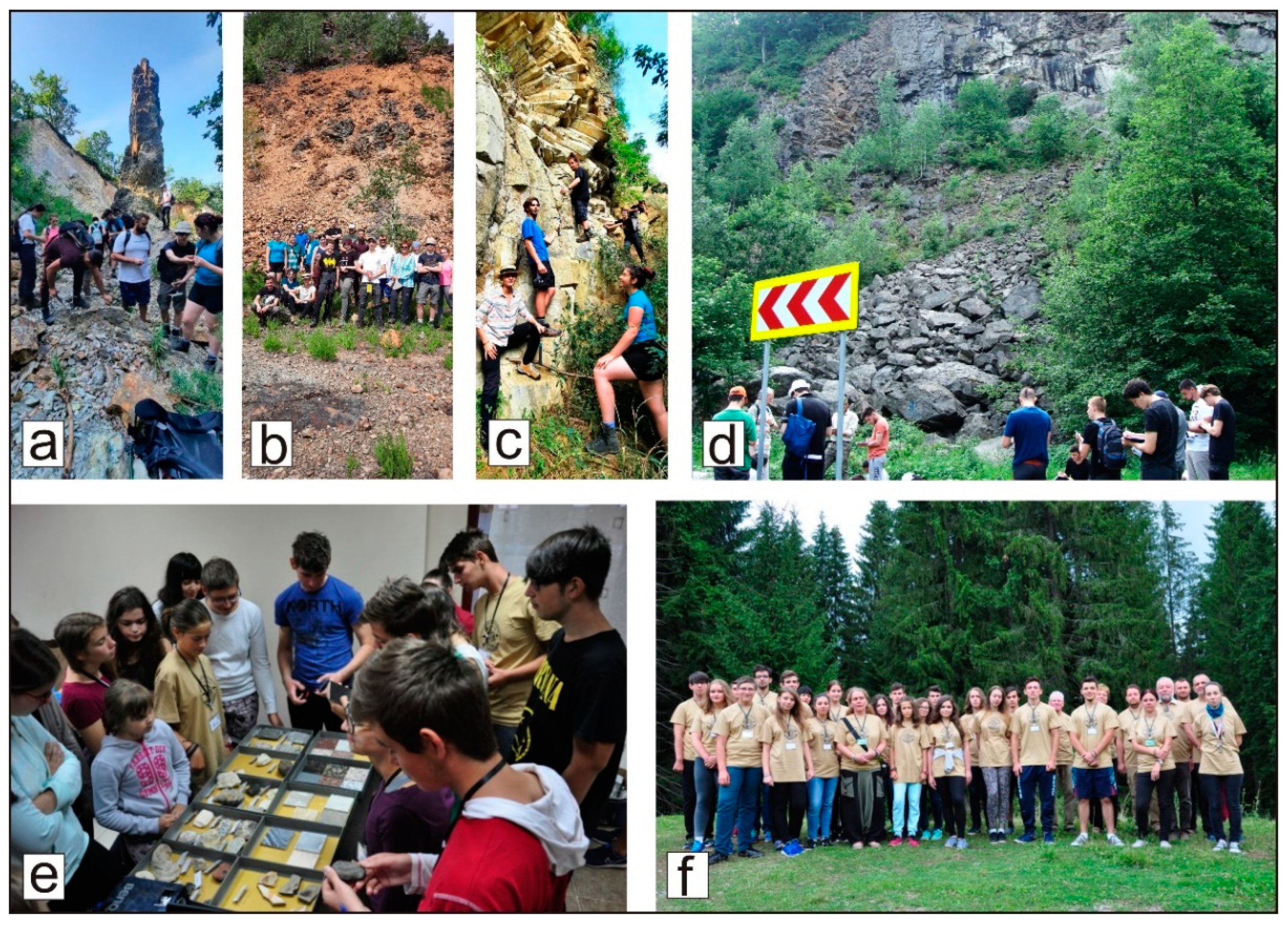
Even before the official start of the geopark project, educational activities involving scholars were initiated in the area of the future geopark and one of them has become an annual event, the summer school “Geodiversity in Maramureș”. This project, with activities carried out with scholars during a week in different locations in the geopark area, was organized in recent years by the Mineralogical Museum together with the County Scholar Inspectorate [61] (Figure 15e,f).
Another annual activity carried out in the area of the geopark is represented by scientific field trips and scholar hands-on activities for students from different universities from Romania. All of these scholarly field applications include, besides the most important geosites in the area (Figure 15a–d), a well-documented visit to the Mineralogical Museum in Baia Mare.
(2) The implementation of the geotourism concept at the geopark level. Geotourism is considered geological tourism with focus on geology and its interaction with ecology and culture [62]. On the other hand, geotourism is considered an emerging form of sustainable tourism [63], which can foster sustainable economic benefits for local communities based on their geoheritage [64]
In the area of the future geopark, the geotourism development may be realized based on the harnessing of all the patrimonial values (geological, mining, natural and cultural). In this regard, we propose as the main means the following: (a) the development of a visiting infrastructure, including sites belonging to all the identified patrimonial values; (b) the achievement of the geopark map with the most interesting routes as well as maps and brochures for certain areas of the geopark; (c) the online and at the dedicated site of the geopark promotion by representative geotouristic routes illustrated by photos and video-films; (d) the implementation of a strong partnership between geopark staff and the local and national travel operators; (e) the use of the museum network existing in the Baia Mare city; (f) the involvement of the local craft artists and peoples in many localities in the geopark area; (g) stimulating the communities to promote their own patrimonial values, including local traditions, festivals and hand-made products (as “geo”-products); (h) the involvement of the local food producers’ associations to promote their products under the geopark brand; (i) the establishment of Touristic Information Centers in all the cities and communes from the geopark for better promotion of the local touristic offers, based on the geopark heritage values; (j) stimulating tourist guesthouses to establish a network at the level of the geopark in order to promote the geopark at regional, national and international level; and (k) improving the geotourism development strategy based on the specialized studies regarding the geopark’s attractiveness assessment along the geopark project development.
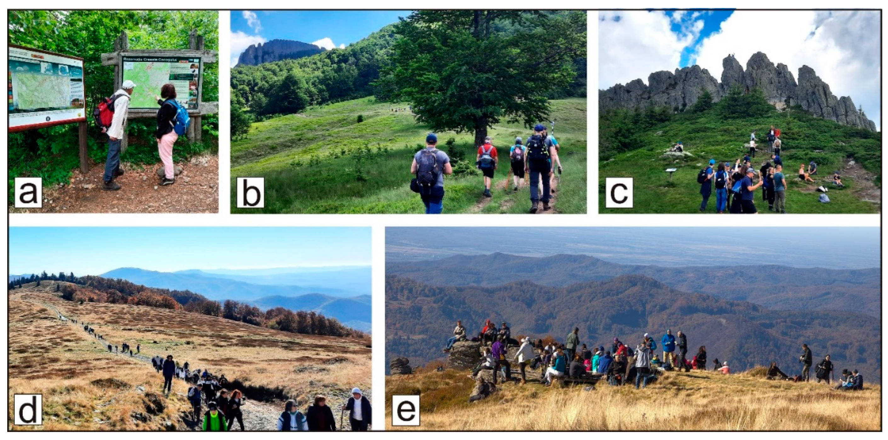
In the design of the visiting infrastructure, one must start from the inclusion of the geosites as the main points to visit, both from a geotouristic and a geoeducational point of view. The experience of the authors in organizing thematic excursions to some of the most significant geosites in the area of the geopark will be used for this purpose. The participants in these trips were outdoor hiking enthusiasts, mountaineers, members of tourist clubs and NGOs, of all ages (including scholars and students). Field trips along two of the most popular geotrails in the area are organized each year: to the “Rooster’s Crest” geosite, to celebrate the World Environment Day (5 June, Figure 16a–c), and to the top of the Igniș volcano, to celebrate the International Geodiversity Day (October 6, Figure 16d,e). Participants receive information about the geosites and biodiversity elements encountered along the routes from expert geologists and biologist, together with printed materials (brochures, flyers).
The experience achieved during numerous scientific field trips related to important international conferences (IAVCEI, IMA, UNESCO IGCP356, and GEODE-ESF projects, Romanian Geological Society) organized in the Gutâi Volcanic Zone will also be valorized in the development of geotourism in the proposed geopark. The Mineralogical Museum, with its impressive collection of outstanding ore minerals exclusively originating from the Baia Mare mining region, will play a key role in the geotourism development. The exhibition of the ten minerals described for the first time in the world originating from the area of the geopark is, and continues to be, the highlight for visitors, enhancing their consciousness and pride related to the local patrimonial values.
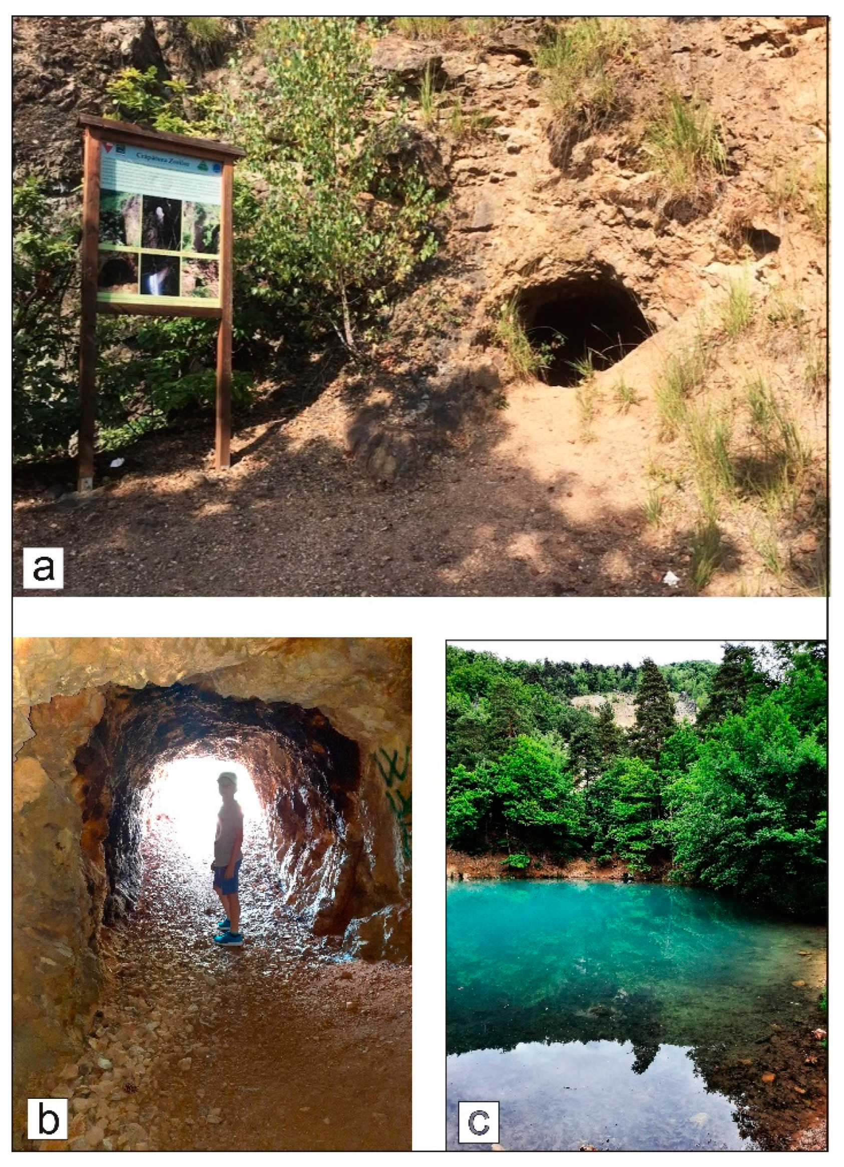
The geotourism networks should also include mining heritage sites, many of them located in the proximity of the geosites. An example of a combined geo- and mining tourism route could be that which includes the mining heritage sites in Cavnic town and the geosites nearby: the “Falcon Stones” (Mogoșa volcano), the “Red Stones” and “Bulbucii” from Șurdești. Another example of such a route is that of Dealul Minei (Mine Hill/Mons Medius) in Baia Sprie town, where the mineralizations at the upper part of the old quarry can be visited, as well as the old galleries, shafts, excavations and waste dumps of the mines. The route also includes the picturesque Blue Lake (III IUCN natural protected area), unique in Europe. Recently, the “Mining Parc project” was implemented at the Mine Hill by the local authorities together with the “Maramureş Mining Association”, including visiting routes with explanatory panels and landscape looking viewpoints (Figure 17a–c).
Geotourism also enables people to reconnect with nature. The development of geotourism in the geopark area can be enriched by including the numerous natural protected areas in the geotouristic routes.
Some of the sites of geoheritage significance are located in the European NATURA 2000 network designed in the area. The partnership with local NGOs concerning ecotourism activities will enhance the development of sustainable tourism as geotourism is currently considered. Among many such organizations in the region, a remarkable example is the NGO “The friends of Rooster’s Crest”, with more than 30 years of activity in promoting the geosite and European NATURA 2000 site, with the same name as from the geopark. It is worth mentioning that the first Eco-Destination Zone in Romania “Mara-Cosău-Creasta Cocoșului/Rooster’s Crest” represents the area in the geopark that includes a large number of geological, natural and cultural heritage sites. The declared goal of the ecotourist destination is “to develop, together with the locals and tourists who are our guests, a responsible tourism, based on respect for the natural and cultural values of this place” [65]. The “Eco-Maramureș” brand, under which the ecotourist destination operates, offers marked tourist routes with printed guides and maps that access natural protected areas, cycling routes, climbing and paragliding, wildlife observation and photography.
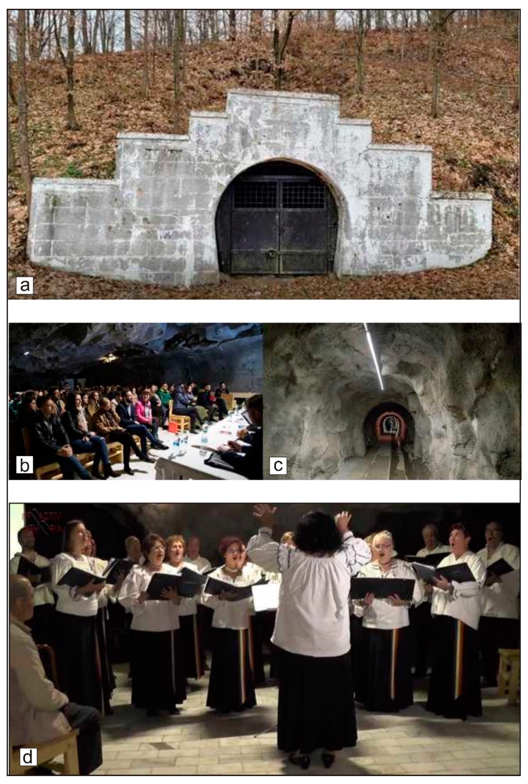
Considering that geotourism focuses on geology and its interaction with ecology and culture [62], and as geotourism concerns both environmental and cultural aspects of a region [66], the rich cultural patrimonial values found in the geopark area can play an important role in the development of a such tourism. Many geosites and mining heritage sites are located in the vicinity of several important cultural heritage sites, and this is an opportunity to develop mixed touristic routes that include these diverse spots of interest. Along a such a route, such as the Cavnic–Baia Mare road via Șurdești and Baia Sprie, within just a 35 km distance, visitors can contemplate and enjoy several geosites, mining sites and cultural sites (including two UNESCO World Heritage List wooden churches). Combined mining–cultural touristic activities are already offered to the educated general public by organized cultural events, such as concerts and drama presentations, hosted by rehabilitated galleries near the shaft number 5 of the closed Baia Sprie mine (Figure 18).
A key role in the development of combined geo-cultural tourism is played by the museums network from the Baia Mare city. Each year, thousands of tourists (including pupils and students) traditionally visit the Mineralogical Museum, and their number will increase significantly through the implementation of the geopark project. A combined visit to the Mineralogical Museum (asignificant ex-situ geosite) and the mining section of the History–Archaeology Museum leads to a better understanding of the origin of minerals and the mining activity of the ore deposits in which they were formed. An exciting experience can also be visiting the other museums of this network—Art Museum exposing numerous paintings of the renowned “Baia Mare painting school”, many of them illustrating landscapes from the geopark’s volcanic area, as well as the Ethnography and Folk Art Museum and amazing Village Museum with rich patrimony of the geopark’s territory origin.
The five wooden churches included in the UNESCO World Heritage List are part of a traditional, well-established and specific cultural touristic route for domestic and international visitors.
In addition to the tangible cultural heritage, the rich intangible cultural heritage in the area, well known at the national and international levels, contribute to the development of cultural tourism. The well-preserved traditions of the local communities, such as Christian holidays, and old crafts (wood carving, pottery, textiles, icons painting) found in many of the villages in the area of the future geopark (especially from the northern part) are also considered to be significant elements in the development of cultural tourism. Moreover, by stimulating their development and by promoting them under the brand of the future UNESCO Global Geopark, these intangible cultural assets of the area will contribute to the economic development of the respective communities.
The strategy regarding the promotion of sustainable tourism in the area of the future geopark is focused on the valorization of all the inventoried patrimonial values (geological, mining, natural, cultural), with the involvement of local communities at all levels, from the authorities to the inhabitants of the cities and villages, in order to enhance their awareness of the heritage values that they own.

5. Conclusions

One of the main goals of this paper was to inventory and present all the significant heritage values that can constitute essential assets of sustainable tourism in the future “Gutâi-Maramureș” UNESCO Global Geopark. The location of the proposed geopark in an area with a complex volcanic activity has facilitated the inventory and description of numerous geological sites of high scientific significance, represented by various volcanic structures (composite volcanoes, domes and dykes), volcanic deposits and rocks, and numerous spectacular residual landforms. Geoheritage includes the most important natural patrimonial values based on which geotourism can be developed in the future geopark. In this regard, a key role can also be played by the sites representing the mineral type localities (four localities—Baia Sprie, Baia Mare, Cavnic, Chiuzbaia—of the ten minerals discover and described for the first time in the world), the fossil flora type locality (Chiuzbaia fossiliferous reserve), and the ex-situ geosite represented by the Mineralogical Museum from Baia Mare with its amazing minerals collection.
The mining heritage sites could contribute to the development of mining tourism in the area and, due to their location in the proximity of many geosites, may be included in the geotourism networks.
The great number of natural/biodiversity heritage sites—of III and IV IUCN type—and European NATURA 2000 sites (one designated as a UNESCO World Heritage site) could be the basis for the development of ecotourism in the proposed geopark. The connection between natural/biodiversity and geological sites through their location in neighboring areas or even their overlapping offers the possibility of their integration into mixed geotourism–ecotourism routes, leading to a closer connection between the local inhabitants and nature.
The numerous cultural objectives of great patrimonial value, recognized at the national and international levels (five UNESCO sites), presented in this paper represent important assets in the development of sustainable tourism, including cultural tourism in the proposed geopark.
The geological and mining heritage is the core concept of the geopark project and it offers the foundation for a sustainable endeavor that integrates geology, tangible and intangible cultural heritage, history, architecture, landscape and offers a heritage values-based sustainable tourism and educational opportunities to ensure long-term viability and positive impact.
The research methodology presented in this paper was developed in order to define the territory of the future geopark, its heritage and development objectives that align with local needs and international criteria. Our research serves as a foundation for the geopark project development and implementation of the first steps to be taken so far. The integrated inventory and assessment are bringing clear evidence of the feasibility of the “Gutâi-Maramureș” UNESCO Global Geopark Project, presenting clear evidence of the geopark’s core values and the potential to drive economic growth, education, and sustainable tourism and the strong opportunities for local administrations to support and invest in the project. The implementation of the geoeducation and geotourism concepts should lead to the development of sustainable tourism by harnessing all the patrimonial values in the potential “Gutâi-Maramureș” UNESCO Global Geopark.
We consider that the “Gutâi-Maramureș” UNESCO Global Geopark project has great potential to become a de facto UNESCO Geopark and to transform the region by using its unique geological, natural and cultural assets.

Author Contributions

Conceptualization: M.K., A.S. and A.A.; writing—original draft preparation: M.K., A.S., A.A. and I.D.; writing—review and editing: M.K., A.S. and A.A.; supervision: M.K., A.S. All authors have read and agreed to the published version of the manuscript.

Funding

This research received no external funding.

Data Availability Statement

The original contributions presented in this study are included in the article. Further inquiries can be directed to the corresponding author.

Acknowledgments

The authors would like to thank all those who kindly provided photographs. Special thanks to Rada Pavel for the data and information provided about the historical monuments. The valuable comments and suggestions of the anonymous reviewers contributing to the improvement of the early version of the manuscript is highly appreciated.

Conflicts of Interest

The authors declare no conflicts of interest.

References

  1. Zouros, N. The European Geoparks Network. Geological heritage protection and local development. Episodes 2004, 27, 165–171. [Google Scholar]
  2. Zouros, N. Global Geoparks Network and the new UNESCO Global Geoparks Programme. Bull. Geol. Soc. Greece 2016, 50, 284–292. [Google Scholar]
  3. UNESCO Global Geoparks. Available online: https://www.unesco.org/en/iggp/geoparks/about (accessed on 25 January 2024).
  4. Global Geoparks Networks. Available online: https://www.globalgeoparksnetwork.org/ (accessed on 25 January 2024).
  5. Martini, G.; Zouros, N. Geoparks a vision for the future. Geosciences 2008, 8, 182–189. [Google Scholar] [CrossRef]
  6. Alexandrowicz, Z.; Kozlowski, S. From selected geosites to geodiversity conservation—Polish example of modern framework. In Towards the Balanced Management and Conservation of the Geological Heritage in the New Millenium; Barettino, D., Vallejo, M., Gallego, E., Eds.; Sociedad Geológica de España: Madrid, Spain, 1999; pp. 40–44. [Google Scholar]
  7. Kozlowski, S. Geodiversity. The concept and scope of geodiversity. Prz. Geol. 2004, 52, 833–837. [Google Scholar]
  8. Gray, M. Geodiversity: Valuing and Conserving Abiotic Nature; John Wiley and Sons: New York, NY, USA, 2004; p. 434. [Google Scholar]
  9. Gray, J.M. Geodiversity: Developing the paradigma. Proc. Geol. Assoc. 2008, 119, 287–298. [Google Scholar]
  10. Brilha, J. Inventory and quantitative assessment of geosites and geodiversity sites: A review. Geoheritage 2016, 8, 119–134. [Google Scholar]
  11. Reynard, E.; Brilha, J. Geoheritage: A multidisciplinary and applied research topic. In Geoheritage: Assessment, Protection, and Management; Elsevier: Amsterdam, The Netherlands, 2018; pp. 3–9. [Google Scholar]
  12. Hose, T.A. European geotourism—Geological interpretation and geoconservation promotion for tourists. In Geological Heritage: Its Conservation and Management; Barretino, D., Wimbledon, W.A.P., Gallego, E., Eds.; Instituto Tecnologico GeoMinero de Espana: Madrid, Spain, 2000; pp. 127–146. [Google Scholar]
  13. Buckley, R. Research note: Environmental Inputs and Outputs in Ecotourism; Geotourism with a Positive Triple Bottom Line? J. Ecotour. 2003, 2, 76–82. [Google Scholar]
  14. Dowling, R.K. Geotourism’s Global Growth. Geoheritage 2011, 3, 1–13. [Google Scholar]
  15. Hose, T.A. Editorial: Geotourism and Geoconservation. Geoheritage 2012, 4, 1–5. [Google Scholar]
  16. Newsome, D.; Dowling, R. Geoheritage and Geotourism. In Geoheritage Assessment, Protection, and Management; Elsevier: Amsterdam, The Netherlands, 2018; pp. 305–321. [Google Scholar]
  17. Istvan, D.; Bernad, A.; Edelstein, O. Possibilities of valorization and protection of the geotourism potential of the Volcanic Mountains in Maramureș County. In Proceedings of the 4th National Colloquium on the Geography of Tourism, București, Romania; 1977; pp. 97–104. (In Romanian). [Google Scholar]
  18. Kovacs, M.; Fülöp, A. Baia Mare Geological and Mining Park—A potential new Geopark in the northwestern part of Romania. Stud. Univ. Babes-Bolyai Geol. 2009, 54, 27–32. [Google Scholar]
  19. Fülöp, A.; Kovacs, M. Managing the geodiversity in Baia Mare region; from scientific to public interest. Stud. Univ. Babes-Bolyai Geol. 2010, 55, 5–8. [Google Scholar]
  20. Szakács, A.; Kovacs, M. Volcanic Landforms and Landscapes of the East Carpathians (Romania) and Their Geoheritage Values. Land 2022, 11, 1064. [Google Scholar] [CrossRef]
  21. Kovacs, M.; Szakács, A.; Denuț, I.; Gál, Á. Geosite assessment in a volcanic area. Case study: Miocene Gutâi Volcanic Zone, NW Romania. In Proceedings of the Volcandpark 2024, Jičin, Czech Republic, 20–24 May 2024; pp. 29–30. [Google Scholar]
  22. Pécskay, Z.; Lexa, J.; Szakács, A.; Seghedi, I.; Balogh, K.; Konecny, V.; Zelenka, T.; Kovacs, M.; Póka, T.; Fülöp, A.; et al. Geochronology of Neogene magmatism in the Carpathian arc and intra-Carpathian area. Geol. Carpath. 2006, 57, 511–530. [Google Scholar]
  23. Physical Map of Europe. Available online: https://ontheworldmap.com/europe/physical-map-of-europe.jpg (accessed on 28 December 2024).
  24. Maps on the Web. Territory of the Carpathian Mountains Laying in Different Countries. Available online: https://mapsontheweb.zoom-maps.com/post/638740939534385152/territory-of-the-carpathian-mountains-laying-in (accessed on 28 December 2024).
  25. Kovacs, M.; Fülöp, A. Neogene volcanism in Gutâi Mts. (Eastern Carpathians). A review. Stud. Univ. Babes-Bolyai Geol. 2003, 48, 3–16. [Google Scholar] [CrossRef]
  26. Fülöp, A. Transport and emplacement of the 15.4 Mă rhyolitic ignimbrites from Gutai Mts., Eastern Carpathians, Romania. Stud. Univ. Babes-Bolyai Geol. 2002, XLVII, 65–75. [Google Scholar] [CrossRef]
  27. Kovacs, M.; Seghedi, I.; Yamamoto, M.; Fülöp, A.; Pécskay, Z.; Jurje, M. Miocene volcanism from the Oaş-Gutâi Volcanic Zone (Eastern Carpathians, România)—Link to the geodynamic processes of Transcarpathian Basin. Lithos 2017, 294, 304–318. [Google Scholar]
  28. Edelstein, O.; Pécskay, Z.; Kovacs, M.; Bernad, A.; Crihan, M.; Micle, R. The age of the basalts from Firiza zone, Igniş Mts., East Carpathians, Romania. Révue Roum. Geol. 1993, 37, 37–41. [Google Scholar]
  29. Lang, B.; Edelstein, O.; Steinitz, G.; Kovacs, M.; Halga, S. Ar-Ar dating of adularia—A tool in understanding genetic relations between volcanism and mineralization: Baia Mare area (Gutâi Mountains), northwestern Romania. Econ. Geol. 1994, 89, 174–180. [Google Scholar]
  30. Direcția Județeană de Cultură Maramureș. Lista Monumentelor Istorice din Maramureș. Available online: https://www.cultura-maramures.ro/wp-content/uploads/2020/06/LMI-MM-2015.pdf (accessed on 8 January 2025).
  31. Direcția Județeană de Cultură Maramureș. Available online: https://www.cultura-maramures.ro/patrimoniul-cultural/patrimoniu-unesco (accessed on 8 January 2025).
  32. Gál, Á.; Szakács, A.; Ionescu, C.; Kovacs, M. Mineral- and rock type localities in Romania and their potential geoheritage value. Geoheritage 2024, 16, 5–26. [Google Scholar] [CrossRef]
  33. Denuţ, I.; Kovacs, M.; Bereș, I.; Sîngeorzan, A. A cultural institution as a geotourism attraction: Baia Mare Mineralogical Museum (Romania). In Proceedings of the XXII International Congress of the Carpathian Balkan Geological Association, Plovdiv, Bulgaria, 7–11 September 2022; p. 237. [Google Scholar]
  34. Manilici, V.; Giușcă, D.; Stiopol, V. Study of Baia Sprie ore deposit. In Memoriile Comitetului Geologic; Institutul Geologic Bucuresti: Bucuresti, Romania, 1965; Volume VII, pp. 1–95. (In Romanian) [Google Scholar]
  35. Haidinger, W.M.W. Uber den Felsőbanyit, eine neue Mineralspecies. Sitzungsberichte Math.-Naturwissenschaftlichen Cl. Kais. Akad. Wiss. 1854, 12, 183–190. [Google Scholar]
  36. Schroeckinger, J. Dietrichit, ein neuer Alaun aus Ungarn. Verhandlungen K.K. Geol. Reichsanst. Wien 1878, 1878, 189–191. [Google Scholar]
  37. Schroeckinger, J. Vortrage. II. Szmikit, ein neues mangansulphat. Verhandlungen Kais. -K. Geol. Reichsanst. 1877, 1877, 115–117. [Google Scholar]
  38. Krenner, J.S. A new lead ore found at Felsőbanya. Magy. Tudományos Akadémia Értesitője 1881, 15, 111–113. [Google Scholar]
  39. Krenner, J.S. Andorit, új hazai ezüstércz. Mathem Természettudom Értesitő 1892, 11, 119–122. (In Hungarian) [Google Scholar]
  40. Moëlo, Y.; Makovicky, E.; Karup-Møller, S. New data on the minerals of the andorite series. Neues Jahrb Miner. Mon. 1984, 1984, 175–182. [Google Scholar]
  41. Zsivny, V. Klebelsbergit, ein neues Mineral von Felsőbanya. Mat. Természettudományi Értesitő 1929, 46, 19–26. [Google Scholar]
  42. Hausmann, J.F.L. Rhodochrosit. In Handbuch der Mineralogie, 2nd ed.; Vandenhoek und Ruprecht: Gottingen, Germany, 1813; Volume 3, p. 302. [Google Scholar]
  43. Krenner, J.S.; Loczka, J. Fizelyit, egy új magyar ezüstérc. Mathem Természettudom Értesitő 1923, 40, 18–21. [Google Scholar]
  44. de Finaly, I.; Koch, S. Fülöppite, a new Hungarian mineral of the plagionite-semseyite group. Mineral Mag. 1929, 22, 179–184. [Google Scholar]
  45. Topa, D.; Sicher, P.; Keutsch, F.; Kolitsch, U.; Stanley, C. Baiamareite. Mineral. Mag. 2023, 87, 955–988. [Google Scholar]
  46. Givulescu, R. Fossil Flora of Upper Miocene in Chiuzbaia, Maramureş County; Editura Academiei Române: Bucharest, Romania, 1990; p. 236. (In Romanian) [Google Scholar]
  47. Macovei, G. The Pannonian Flora of the Chiuzbaia Fossiliferous Site; Editura Bibliotecii Județene “Petre Dulfu”: Baia Mare, Romania, 2023; p. 171. (In Romanian) [Google Scholar]
  48. Kovacs, M.; Fülöp, A. Dealul Minei open pit, Baia Sprie. In Ore Deposits and Other Classic Localities in the Eastern Carpathians: From Metamorphics to Volcanics; Iancu, O.G., Kovacs, M., Eds.; IMA 2010 Field Trip Guide RO1, Acta Mineralogica-Petrografica; University of Szeged: Szeged, Hungary, 2010; Volume 19, pp. 27–32. [Google Scholar]
  49. Pop, L.; Rusu, V. Rivulus Dominarum 690. In Medieval Historical Vestiges and Testimonies; Editura Eurotip: Baia Mare, Romania, 2019; p. 99. (In Romanian) [Google Scholar]
  50. Iștvan, D.; Minghiraș, T. Middle Age gallery from Dealul Crucii. Pro. Unione 2004, VII, 127–129. (In Romanian) [Google Scholar]
  51. Mureșan, A.; Minghiraș, T.; Dragoș, C.; Tămaș, T. The Thurzó canal: A XVIth century aqueduct from Baia Mare (Maramureș, Romania). In Proceedings of the 18th International Congress of Speleology, Le Bourget du Lac, France, 24–31 July 2022. [Google Scholar]
  52. Orașul Cavnic.ro-Prima Pagină a Orașului de la Poalele Gutâiului. Available online: https://orasulcavnic.ro (accessed on 3 January 2025).
  53. Muzeul Judeţean de Istorie şi Arheologie Baia Mare. Available online: https://www.muzeubaiamare.ro/despre-noi (accessed on 3 January 2025).
  54. ANPM-Reteaua de arii Protejate din Județul Maramureș. Available online: https://www.anpm.ro/documents/23445/49936335/2020.06.05+Ariile+naturale+protejate+din+Maramures.pdf/66d40eae-1258-4fd5-b46f-0bb618273ad1/ (accessed on 6 January 2025).
  55. Pop, L.; Rusu, V. Buildings, edifices, monuments and statues with a story. In A Different History of the City of Baia Mare; Editura Eurotip: Baia Mare, Romania, 2021; p. 224. (In Romanian) [Google Scholar]
  56. Muzeul Judeţean de Etnografie şi Artă Populară Maramureş. Available online: https://etnografie-maramures.ro/muzeul-satului-baia-mare/ (accessed on 12 January 2025).
  57. Muzeul Județean de Artă «Centrul Artistic Baia Mare». Available online: https://muzartbm.ro/centrul-artistic-baia-mare-1896-2007 (accessed on 12 January 2025).
  58. Checklist to Define an Aspiring UNESCO Global Geopark (aUGGp). Available online: https://unesdoc.unesco.org/ark:/48223/pf0000383838 (accessed on 19 February 2025).
  59. Brocx, M.; Semeniuk, V. The ‘8Gs’—A blueprint for Geoheritage, Geoconservation, Geo-education and Geotourism. Aust. J. Earth Sci. 2019, 66, 803–821. [Google Scholar]
  60. Henrique, M.H.; Brilha, J. UNESCO Global Geoparks: A strategy towards global understanding and sustainability. Episodes 2017, 40, 349. [Google Scholar]
  61. Denuț, I.; Sîngeorzan, A. Educational projects from the Baia Mare museum of mineralogy. Rev. Stud. Comunicări 2020, 29, 58–62. [Google Scholar]
  62. Chen, A.; Lu, Y.; Ng, Y.C.Y. The Principles of Geotourism; Springer Geography; Science Press: Beijing, China; Springer: Berlin/Heidelberg, Germany, 2015; p. 263. [Google Scholar]
  63. Dowling, R.K. Global geotourism—An emerging form of sustainable tourism. Czech J. Tour. 2014, 2, 59–79. [Google Scholar]
  64. Gordon, J.E. Geoheritage, Geotourism and the Cultural Landscape: Enhancing the Visitor Experience and Promoting Geoconservation. Geosciences 2018, 8, 136. [Google Scholar] [CrossRef]
  65. Ecoturism în Maramureș-Eco Maramureș. Available online: https://www.ecomaramures.com/4-despre-noi/4-1-cine-suntem/ (accessed on 20 January 2025).
  66. Olson, K.; Dowling, R. Geotourism and cultural heritage. Geoconserv. Res. 2018, 1, 37–41. [Google Scholar]
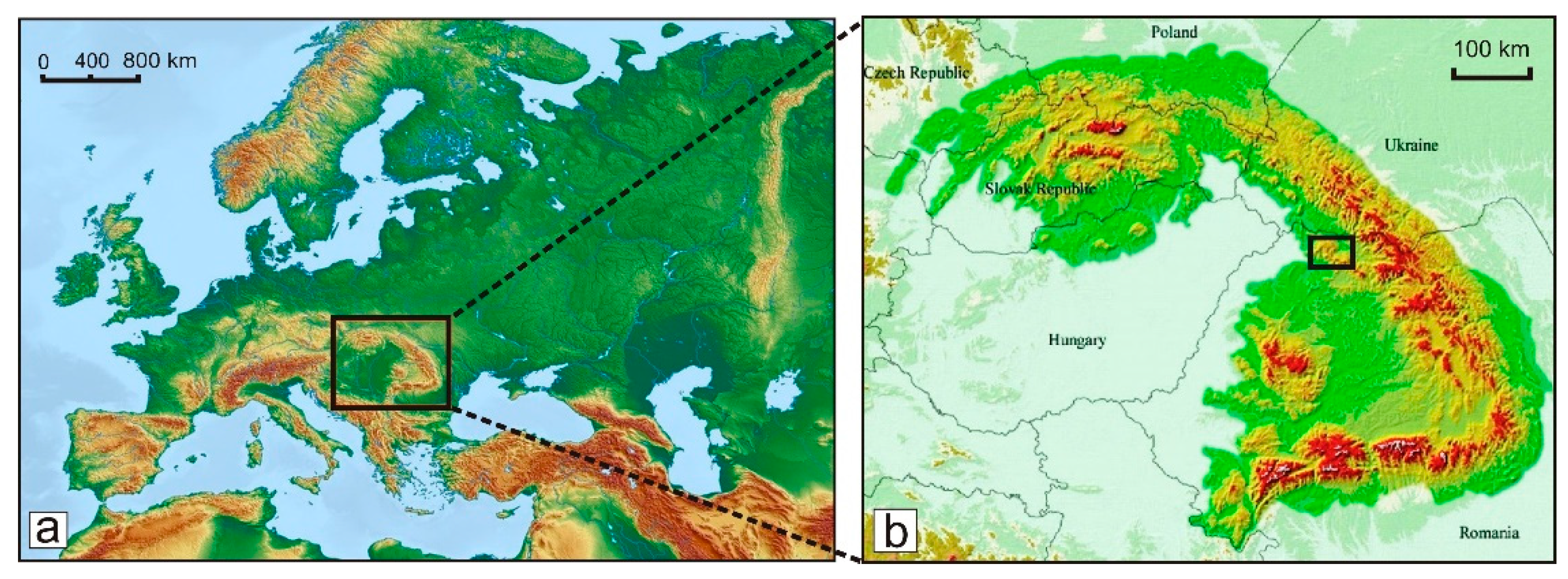
Figure 1. (a) Geographical location of the Carpathian–Pannonian region (CPR) on the physical map of Europe; and (b) location of the Gutâi Volcanic Zone (framed) within the physical map of the Carpathian–Pannonian region. Maps’ sources: [23,24].
Land 14 00726 g001
Figure 2. Simplified geological map of the Gutâi Volcanic Zone (acc. to [25], (a)) and the space–time evolution of volcanism (b). Legend: (1) Paleogene sedimentary deposits; (2) Neogene sedimentary deposits; (3) Badenian felsic volcaniclastics (rhyolitic ignimbrites and their resedimented counterparts (F); (4) Badenian–Sarmatian intermediate-composition volcanics (I1); (5) Pannonian intermediate-composition volcanic rocks (I2); (6) Laleaua Albă magmatic complex (I3); (7) Firiza basaltic complex (I4); and (8) Intrusive magmatic bodies (dykes, sills, laccolites) associated with the intermediate-composition volcanism.
Land 14 00726 g002
Figure 3. Simplified geological map of the Gutâi Volcanic Zone (acc. to [27]) with the geosite locations in the area of the proposed geopark. (1) Ilba “Stone Rosette”; (2) Nistru welded ignimbrites; (3) Limpedea Pillars; (4) Blue Lake; (5) “Giant’s Garden”, Baia Sprie; (6) Dănești–Cetățele composite dome; (7) “Bulbuci”, Șurdești; (8) “Red Stone”, Șurdești; (9) Cavnic sill; (10) “Falcon Stones”, Mogoșa; (11) Mogoșa composite volcano; (12) Poiana Botizii “Pienniny Klippen belt” zone; (13) Senonian red marls at Poiana Botizii; (14) “Rooster’s Crest”; (15) “White Tulipe” composite dykes; (16) “Serpentinele Gutinului” volcaniclastic complex; (17) Chiuzbaia paleobotanical fossiliferous reserve; (18) Top of the Igniș volcano; (19) Tătaru Gorges; and (20) Lava plateau of northern Gutâi Mts. and Rotundu crater. The map representation of the geology is the same as in Figure 2a (shown in its legend). The area of the proposed geopark is marked by the black line representing the administrative border of the localities included in the geopark.
Land 14 00726 g003
Figure 4. The “Victor Gorduza” County Mineralogical Museum in Baia Mare. (a) Interior view of the permanent exhibition. (bf) Selected mineral specimens exposed in the museum: (b) rhodochrosite (pink) and quartz from Cavnic mine (10 × 6 × 7 cm); (c) semseyite from Herja mine (2.5 cm); (d) red barite from Baia Sprie mine (12 × 8 × 6 cm); (e) antimonite–stibnite from Herja mine (13 × 10 × 7 cm); (f) quartz–amethyst from Cavnic mine (12 × 8 × 7 cm). (Photo credit: Ioan Bereș—(a); Valentin Ganța—(bf)).
Land 14 00726 g004
Figure 5. Representative geosites with official protection status in the proposed geopark: (a) Limpedea Pillars (III IUCN); person climbing for scale; (b) Ilba “Stone Rosette” (III IUCN); (c) “Creasta Cocoșului” (“Rooster’s Crest”) (IV IUCN); and (d) Tătaru Gorges (IV IUCN). (Photo credits: Péter Lengyel—(a,c,d); Marinel Kovacs—(b)).
Land 14 00726 g005
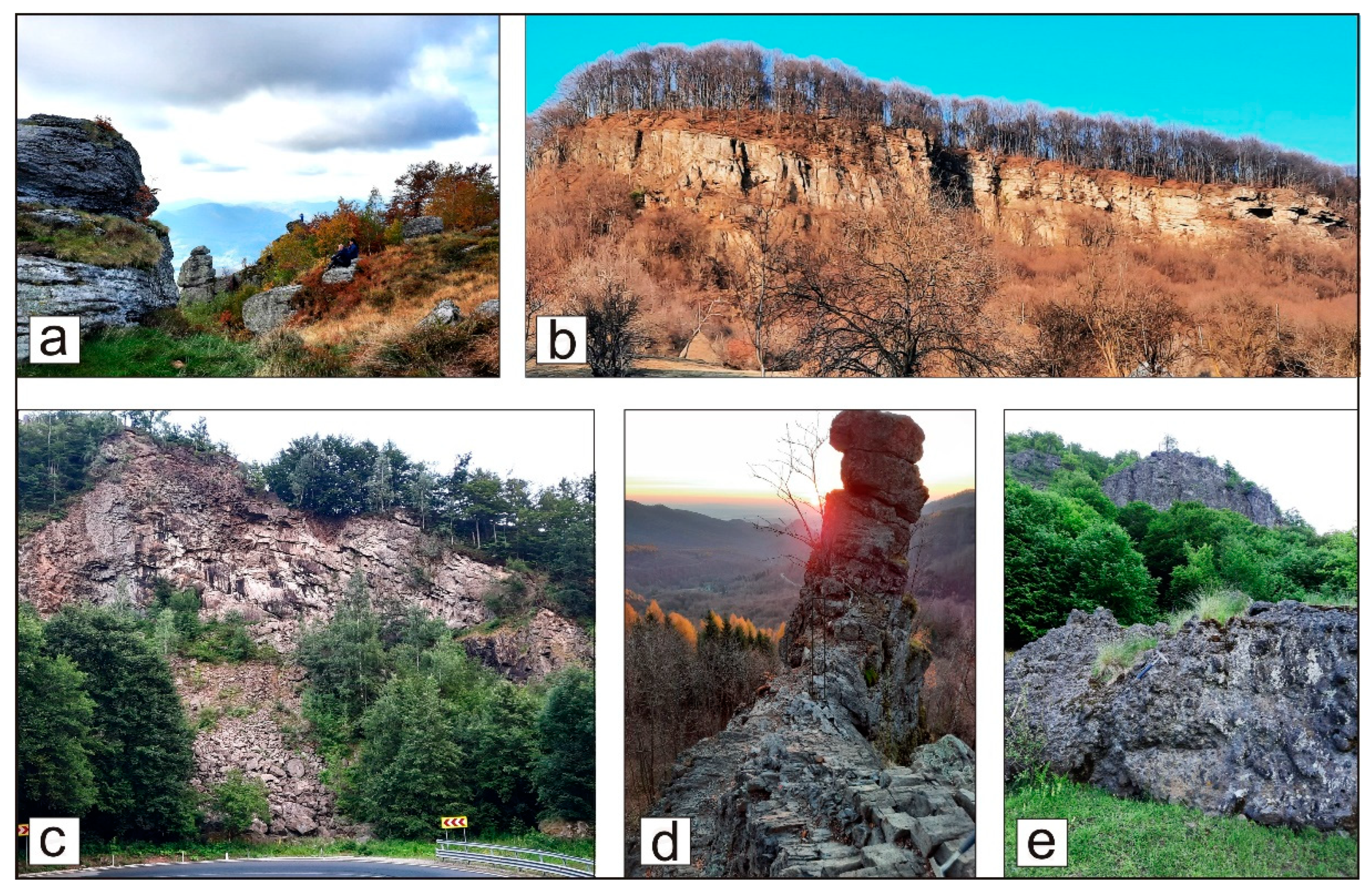
Figure 6. Selected geosites with no official protection status in the proposed geopark: (a) Top of the Igniș volcano with residual landforms (rock pillars, towers and tors); (b) “Red Stone” hill escarpment (Șurdești) exposing in situ and resedimented dacitic hyaloclastites; (c) “Laleaua Albă” (“White Tulipe”) quarry composite dyke (andesite and dacite); (d) “Vlaicu’s Church” composite dyke exposure of the Laleaua Albă magmatic complex; and (e) “Falcon Stones” (Mogoșa volcano) escarpment in volcaniclastic deposits at the contact with Pannonian sedimentary deposits with many large-sized blocks at the base detached from the escarpment (Photo credit: Marinel Kovacs).
Land 14 00726 g006
Figure 7. Centuries-old mining activity in Baia Sprie town: (a) Dealul Minei/Mine Hill (Mons Medius) today, testifying to more than 700 years of mining activity (Igniș volcano can be seen in the northeastern corner of the picture); (b) mining activity in the eastern part of the Mine Hill as depicted in a painting from the year 1773; (c) mining works in the Mine Hill open pit about 40 years ago; and (d) main access gallery of the Baia Sprie mine closed in 2006 (Photo credits: Marinel Kovacs—(a); Baia Mare Historical and Archaeological Museum collection—(b); Environmental Engineering department of the Baia Mare North University Centre collection—(c); Traian Minghiraș—(d)).
Land 14 00726 g007
Figure 8. Mining heritage in Cavnic town: (a) German language inscription found in an old gallery of the mine; (b) historical marking pole at the border between mining concessions dated 1865, presently found in the courtyard of an old miner’s house from the old part of the town; (c) the bust statue of Ignac von Born near the Born and Papp museum in Cavnic; (d,e) ruins of the Logolda cyanide-using ore processing plant (1899) located in the old part of the town; and (f) the modern ore processing plant built in 1954 in the vicinity of the new part of the town, closed today (lower right side of the picture). (Photo credits: Carol Kacsó—(ae); [52]—(f)).
Land 14 00726 g008
Figure 9. Mining heritage in Băiuț village: (a) entrance on the original Hell gallery in an old photo; and (b) Hell gallery entrance with the original inscription “Gluck auf Johan Hell 1846”, as seen at the present days. County Museum of History and Archaeology in Baia Mare: (c) view of the interior yard of the museum building, representing the headquarters of the mint built in 1748, with the mining section on the ground floor; (d) wooden cart used for ore transport and further old mining tools exhibited in the mining section of the museum; (e) treasury room of the first gold-refining facility in Romania, operated from 1926 to 1967, in the present-day museum building (Photo credits: Baia Mare Historical and Archaeological Museum collection—(a); Carol Kacsó—(b); [53]—(c); Zamfir Șomcutean—(d,e)).
Land 14 00726 g009
Figure 10. Selected natural protected areas in the proposed geopark: (a) “Dumitru’s Pond” botanical–wetland protected area (III IUCN); (b) Drosera rotundifolia, a carnivorous plant species common in “Dumitru’s Pond”; (c) “Iezerul Mare” marsh on the Northern Slope of the Gutâi Mountains (III IUCN); and (d) Morăreni Lake, a mixed natural protected area (IV IUCN) in the northern part of the “Rooster’s Crest” geosite (mirrored in the lake). (Photos credits: Marinel Kovacs—(a,b); Péter Lengyel—(c,d)).
Land 14 00726 g010
Figure 11. Historical heritage sites in Baia Mare city and neighboring towns: (a) the octagonal seal of Baia Mare town (Rivulus Dominarum) in the 14th century; (b) “Stephen’s Tower”, the preserved part of the old St. Stephen Church built in the 14th century; (c) the old historical center of the Baia Mare city (15–19th centuries) as seen today; (d) the Holy Trinity Roman Catholic Church (built in 1717) in Piața Cetății (Citadel Square); (e) “Butchers’ Bastion” (Ammunition Tower) built in the 14–15th centuries; and (f) the cloister of the Minorite monastery (built in 1734)—detail of the Eastern outer wall. (Photo credits: Paul Seling—(a); Karin Lachner—(b); Rada Pavel—(c,f); Marinel Kovacs—(d); Minerva Luca—(e)).
Land 14 00726 g011
Figure 12. Historical heritage sites in Baia Sprie town in the proposed geopark: (a) panoramic view of the historic center of Baia Sprie town with the two imposing churches: Roman Catholic Church (center) and Reformed Church (left); (b) interior of the “Holy Mary” Roman Catholic Church in Baia Sprie’s historic center; (c) “Stoll’s Fountain”, an iconic statue in the historic center of Baia Sprie; and (d) Baia Sprie City Hall, the original headquarters of the Mines Office, built in 1733. (Photo credits: Karin Lachner—(a,b); Rada Pavel—(c,d)).
Land 14 00726 g012
Figure 13. Wooden churches found in the UNESCO World Heritage List in the proposed geopark: (a) Desești (exterior); (b) Desești (interior wall fresco); (c) Șurdești; (d) Budești; (e) Plopiș; and (f) Poienile Izei. (Photo credits: Péter Lengyel—(a,f); Rada Pavel—(b); Paul Seling—(c); Karin Lachner—(d,e)).
Land 14 00726 g013
Figure 14. The County Museum of Ethnography and Folk Art in Baia Mare: (a) view of the building front; (b) interior view; (c) aerial view of the Village Museum belonging to the Ethnography and Folk Art Museum; (d) entrance of the County Museum of Art “Baia Mare Artistic Centre” located in a historical building built in 1748; and (e) interior view in the County Museum of Art. (Photo credits: Marinel Kovacs—(a); The County Museum of Ethnography and Folk Art in Baia Mare collection—(b); [56]—(c); Rada Pavel—(d); [57]—(e)).
Land 14 00726 g014
Figure 15. Educational activities in the area of the proposed geopark: (a,b) geology students examining and sampling ore minerals in the Mine Hill quarry in Baia Sprie; (c) geology students visiting the “Stone Rosette” geosite in Ilba; (d) geology students in taking notes during field practice at the Laleaua Albă/White Tulip quarry; (e,f) activities during the summer school “Geodiversity in Maramureș”: (e) classroom practical lesson learning about rocks; and (f) group photo of the participants (children and trainers) at the end of the school. (Photo credits: Marinel Kovacs—(ac); Ágnes Gál—(d); Ioan Bereș—(e,f)).
Land 14 00726 g015
Figure 16. Field trips on two of the most popular geotrails in the area of the proposed geopark: (ac) to the Rooster’s Crest geosite, organized in June each year to celebrate the World Environment Day; and (d,e) to the top of the Igniș volcano, organized in every October to celebrate the International Geodiversity Day. (Photo credits: Marinel Kovacs—(ad); Cristian Benone—(e)).
Land 14 00726 g016
Figure 17. Geotourism and mining tourism at Mons Medius (Mine Hill) in Baia Sprie town related to the new Mining Park project: (a) explanation panel near the entrance in one of the old galleries; (b) inside the old gallery shown in (b); and (c) the picturesque “Blue Lake” (a natural protected area) on the Mons Medius visiting trail. (Photo credit: Marinel Kovacs).
Land 14 00726 g017
Figure 18. Mining and cultural tourism in Baia Sprie town: (a) entrance in a rehabilitated gallery near the shaft number 5 of the closed Baia Sprie mine; (b) watching a cultural event in the rehabilitated gallery; (c) rehabilitated access gallery to the underground cultural events location; and (d) chorus performing in a rehabilitated mine precinct. (Photo credit: Alexandru Nicolici).
Land 14 00726 g018
Table 1. Geosites without official protection status from the proposed geopark.
GeositesGeological Type
(acc. Brilha, 2016 [10])
Major Heritage Features
Laleaua Albă/White Tulipe composite dykes Petrological, mineralogical, geomorphologicalTwo composite dykes of external zone of aphyric andesite and internal zone of macro porphyritic dacite. An “open-air mineralogical museum”: sanidine (max. 5 cm), plagioclase, quartz, biotite, amphibole, pyroxene and gabbroic enclaves (up to 90 cm) in dacite. Unique in East Carpathians volcanic range.
Piatra Roșie/Red Stone ȘurdeștiPetrological, geomorphologicalImpressive escarpment within in situ and resedimented dacitic hyaloclastites; most relevant outcrop in hyaloclastite deposits in Gutâi Volcanic Zone (GVZ).
Pietrele Șoimului/Falcon Stones Mogoșa Petrological, geomorphologicalSteep cliffs in phreatomagmatic volcaniclastic and block-and-ash-flow deposits with many large-sized blocks detached from the high escarpment.
Top of the Igniș volcano Petrological, geomorphologicalResidual landforms: rock pillars, rock towers and individual tor-like forms; isolated cliffs with spectacular erosional shapes (the “Igniş Sphinx”).
Mogoșa composite volcanoPetrological, geomorphologicalA compound volcanic dome system, built during several successive dome-forming and dome-collapse events across an unusually long-time span of activity (ca. 2 My).
Nistru welded ignimbritesPetrologicalA thick (30 m) welded ignimbrite sequence consisting of three units, each one topped by pumice-rich layers.
Poiana Botizii Pienniny KlippensStructural, stratigraphicThe only occurrence in Romania of the Jurassic–Cretaceous rocks as remnants of an old ridge of the Tethys Ocean (separating the African–Arabian and Eurasian plates).
“Grădina Uriașilor”/“Giant’s Garden” Baia SprieGeomorphological, petrologicalCluster of andesitic breccia mega blocks at the western foot of the Mogoșa volcano edifice that prove their dome collapse origin.
Cavnic sillPetrologicalA basaltic andesite sill with a visible quasi-horizontal upper contact with Pannonian sedimentary deposits.
Dănești–Cetățele composite domePetrological, geomorphologicalResidual volcanic relief (skeleton-like landform) on two different volcanic rocks: biotite rhyolite of Dănești dome and pyroxene dacite of Cetățele dome with spectacular gorges and rock towers.
Senonian red marls from Poiana BotiziiStratigraphic, structuralUnique outcrops in the Senonian Puchov type red marls in the front of the Botiza overthrust nape.
Serpentinele Gutinului volcaniclastic complexPetrologicalA very thick succession of various volcanic units composed by coherent lava rocks, hyaloclastites, phreatomagmatic breccias, coarse and fine debris flows, fine volcanic epiclastic rocks (outcropping around 3 km along the national road).
Gutâi Northern Slope lavas plateau and Rotundu crater Petrological, geomorphologicalExtended andesitic lava flows that form typical landform (plateau-like) and a large remnant crater (ca. 3 km across) as a semicircular ridge, unique in the GVZ.
“Bulbucii” from ȘurdeștiPetrological, geomorphologicalTwo isolated cliffs as residual erosional landforms within lava flows and volcaniclastics belonging to the Cetățele dome in an area covered by Sarmatian and Pannonian sedimentary deposits.
Table 2. Natural protected areas from the potential “Gutâi-Maramureș” UNESCO Global Geopark.
NoNameLocationSurface
(ha)
TypeIUCN
Category
Relevant Features
1The Cave of BonesPoiana Botizii (Băiuț)0.5SpeleologicalIIIUrsus spelaeus bones
2Vlășinescu Marsh Mara (Desești)3Botanical, wetlandIIIFlora and fauna species specific to wetland and peat bog areas
3Dumitru’s Pond Baia Mare3Botanical, wetlandIIIActive peat bog, with oligotrophic bog vegetation
4Iezerul Mare MarshDesești5Botanical, wetlandIIIMany natural elements specific for wetlands
5Black Pond MarshStrâmbu-Băiuț (Băiuț)1Botanical, wetlandIIINatural habitats and specific oligotrophic peat bog biodiversity
6Morăreni Lake Breb (Ocna Șugatag)20MixedIVBiological diversity of aquatic ecosystem, with representative flora
7Crăiască Forest Ocna Șugatag44ForestryIVVegetation characteristic for this forest: lark and durmast oak
8Comja Pine Tree Forest Seini0.5ForestryIVNatural habitats, wild flora and fauna and biological diversity
9Baia Mare edible chestnut trees forest Tăuții Magherăuș, Baia Mare, Baia Sprie500ForestryIVSweet chestnut tree population, at the northernmost natural limit of the species
Table 3. Representative historical monuments (Category A) within the proposed geopark.
NoNameLocalityMajor Heritage FeaturesDating
1Historic center of Baia Mare cityBaia MareOnce the medieval town of Rivulus Dominarum, the heart of the modern city features heritage buildings from the 15th to 20th centuries in Gothic, Baroque, neoclassical, eclectic, and secession styles. 15–19th centuries
2Stephen’s TowerBaia Mare cityThe single remnant of the iconic medieval “Saint Stephen” Church, which has endured fires, damage, and restorations during the centuries. It preserves Gothic features, old bells and clock mechanism, and its lookout platform offers panoramic views of the city.1347
3Church of St. AntonBaia Mare cityThe city’s oldest surviving church, whose building has undergone numerous architectural changes over the centuries. 1402
4Iancu de Hunedoara houseBaia Mare cityThe oldest building in the city, built in 1446 by the King of Hungary, János Hunyadi (Iancu de Hunedoara), as a residence for his wife, Elisabeta. 15th century
5Butchers’ Bastion (Ammunition Tower)Baia Mare cityA structure built to reinforce the walls against attacks, serving as a strategic defense point near the medieval town’s southern entrance. The recent restoration was completed in 2011 and gave the bastion its current appearance.14–15th centuries
6“Holy Trinity” Church of the former Jesuit monasteryBaia Mare cityBuilt by the Jesuits, the oldest Baroque church in Transylvania and a key landmark for Baia Mare’s Roman Catholic community. 1717–1719
7The historical center of the Baia Sprie cityBaia Sprie town“A” value group monument featuring 18th and 19th century religious and civil buildings. 18th century
8“Holy Mary” Roman Catholic churchBaia Sprie townThe most imposing building in the historic center of the town, renowned for its monumental neoclassical architecture. 1846–1858
Table 4. Wooden churches within the proposed geopark included in the UNESCO World Heritage List.
NoNameLocalityMajor Heritage FeaturesDating
1“Sf. Nicolae” JosaniBudeștiUNESCO World Heritage site, Maramureș county’s largest church when built and still impresses with its expansive width. Inside, it features icons and royal doors painted during 1760–1762. 1643
2“Cuvioasa Paraschiva “DeseștiUNESCO-listed wooden church with well-preserved murals painted in 1780, the only location in Maramureș county where religious services are still regularly held.1770
3“Sf. Arhangheli Mihail și Gavril”Plopiș (Șișești)UNESCO-listed monument, with a stunning sense of proportions, preserving interior murals painted in 1811. 1798
4“Cuvioasa Paraschiva”Poienile IzeiUNESCO-listed wooden church particularly famous for the expressive scenes of the Final Judgment depicted in the pronaos.1700
5“Sf. Arhangheli Mihail și Gavril”Șurdești (Șișești)Oak-built UNESCO-listed church with a 54 m high tower, the tallest wooden church in the world dating before the 20th century.1766
Table 5. Synthesis of the objectives included in the research methodology.
1. Synthesis of Local Geodiversity (A)2. Synthesis of Local Biodiversity (B)3. Document Local Cultural Values (C)
Activities of research and integrated evaluation of geodiversity, biodiversity, and cultural diversity involves a comprehensive and holistic assessment of the three key components and identification of its geological heritage (GH), natural heritage (NH) and its cultural diversity and cultural heritage (CH).
Geological Heritage (GH)
Geological heritage refers to the significant geological features, formations, and processes that have scientific, educational, and touristic value.
Natural Heritage (NH)
Natural heritage, except geological heritage, encompasses all the living components of nature that are considered valuable for their biodiversity, ecosystems, and ecotourism significance.
Cultural Heritage (CH)
Practices and traditions that are intertwined with the land, its people, and its history. It is closely connected to the GH and NH and plays an essential role in shaping the identity and the visitor experience.
4. Realize Two SWOT Analyses for both the “Gutâi-Maramureș” Geopark area and “Gutâi-Maramureș” Geopark project. The results will be used in further geopark project steps to define the optimum territory, its core values, comply with UNESCO Geopark Program requirements and optimize the cooperation and support with local administrations and partners.
5. Develop Geoeducation and Sustainable Tourism Pilot Activities
A way to foster community engagement, raise awareness of the region’s geological, natural and cultural significance, and support local economies. Both approaches are integral to ensuring that the “Gutâi-Maramureș” Geopark area benefits from its rich heritage in a responsible way.
Table 6. SWOT analysis for the “Gutâi-Maramureș” UNESCO Global Geopark Project.
StrengthsWeaknesses
Very rich geological and mining heritage well documented and fulfilling the basic requirement for a UNESCO geopark and strong foundation for scientific, educational, tourism, economic initiatives Not enough administrative partners and funds to stop the loss of the mining heritage, requiring renovation, protection action plans and significant remediation efforts
Geodiversity covers different topics and ages, with unique geologic evolution and volcanic landscape making the geopark an added value when will join the Global Geoparks NetworkTakes time to develop the geopark infrastructure to support sustainable tourism and promote the geological, natural and cultural heritage and prove the role a geopark can play
Rich biodiversity and specific landscapes—the area has diverse ecosystems and scenic landscapes, rich protected areas, enhancing its value for tourists and researchersDifferent mining infrastructure belongs to different owners (communities, former mining company, private ones) and will take time to convince them to cooperate
Cultural and historical significance with a unique cultural identity shaped by centuries of mining and offering a unique blend of industrial heritage and traditional practices that can attract cultural tourismLocal mayoralties are not very used to cooperating outside of their territories
Existence of another UNESCO designations and protected areas with great potential for common promotionLack of public awareness of geological heritage and the role of a geopark
Existence of a unique mineralogical museum and other dedicated museum for history and culture Lack of geology in school curricula
OpportunitiesThreats
Establishing the geopark could be part of the county strategy to promote sustainable tourism, balancing economic growth with heritage preservation and strengthen the cultural identityHeritage degradation due to the lack of coherent local common strategies for heritage conservation
The geopark can serve as a hub for geological and environmental education, attracting researchers, students, and enthusiastsMisunderstanding the geopark potential for local development or lack of support in project development
A geopark strategy could gather and motivate different groups and local people to cooperate and contribute to geopark brand development as a common international valueCompetition with other projects and initiatives
Offers the possibility for international cooperation and promotion within the EGN and GGN even at this stage of the project through the Romanian Geoparks Network, ProGEO Conferences, Erasmus+ projects and other similar programs Insufficient funding and resources for the establishment and maintenance of the geopark may be challenging, especially in the initial stages
Involving local communities in the geopark’s development and activities can create jobs, support local businesses, and foster a sense of ownership and pride
Potential for projects and financial and administrative support for local communities and initiatives related to the geopark project
Disclaimer/Publisher’s Note: The statements, opinions and data contained in all publications are solely those of the individual author(s) and contributor(s) and not of MDPI and/or the editor(s). MDPI and/or the editor(s) disclaim responsibility for any injury to people or property resulting from any ideas, methods, instructions or products referred to in the content.