Article

Integration of Historical and Contemporary Data Sources in Understanding the Extent and Types of Disruptions in the Syrdarya Delta Land Use/Land Cover

1
Desert Architecture & Urban Planning, J. Blaustein Institutes for Desert Research, Sde Boqer Campus, Ben-Gurion University of the Negev, Sde Boqer 849900, Israel
2
Alexander Yersin Department of Environmental Physics, Blaustein Institutes for Desert Research, Ben-Gurion University of the Negev, Beer-Sheva 8410501, Israel
3
Department of Civil and Environmental Engineering, Faculty of Engineering Sciences, Ben-Gurion University of the Negev, Beer-Sheva 8410501, Israel
4
The Goldman Sonnenfeldt School of Sustainability and Climate Change, Ben-Gurion University of the Negev, Beer-Sheva 8410501, Israel
*
Author to whom correspondence should be addressed.
Land 2025, 14(3), 639; https://doi.org/10.3390/land14030639
Submission received: 30 January 2025 / Revised: 5 March 2025 / Accepted: 6 March 2025 / Published: 18 March 2025

Abstract

:
The Syrdarya Delta, located in semi-arid and arid Central Asia, is an important water source for fertile landscapes. The environmental history of the Syrdarya Delta (SD) during the 19th and 20th centuries is a diverse and understudied subject, and its natural and anthropogenic aspects changed drastically during this period. As a result of the Syrdarya Delta’s location, on the shores of the former Aral Sea, there is a vital need to expand our understanding of the phases and policies that led to the current condition. This study argues that by integrating methods from social and natural sciences and applying them to selected historical materials, among them, former classified materials from the Cold War period, we can expand our understanding regarding the extent and types of disruptions in the Syrdarya Delta ecological system. The main findings of this study show that between the second part of the 19th and the 21st centuries, a period of roughly a hundred and fifty years, the SD changed drastically in aspects of urban areas, which increased during the Soviet period, changes in land use and hydrography, with changes in the amounts, size and flowing directions of water streams in the SD. The findings also present changes in vegetative cover and amounts parallel to salinization of the soil, which increased in the 1970s–1980s, and changes in the meeting point of the former Aral Sea with the SD. The findings of the study indicate that most of these changes can be attributed to anthropogenic factors, which have taken place mainly since the 1960s–1970s under the USSR regime. As this study presents, such materials can assist in reconstructing land use and land cover from the years to which our data are limited by integrating them with modern satellite image analysis, thus being able to quantify and estimate the amounts and types of these changes regarding salinization, land use and land cover and hydrology, which are crucial for studying deltas located in arid and semi-arid landscapes, such as the SD. This study presents evidence and argues that these data are of pivotal importance and should be used when attempting to rehabilitate and manage today’s Syrdarya Delta landscapes and hydrology.

1. Introduction

The Syrdarya River (SR), originating in the mountains of Tian Shan, crosses various countries in Central Asia (CA), including Kyrgyzstan and Kazakhstan. Its lower streams and its delta are located on the eastern shores of the Aral Sea, in present-day Kazakhstan [1,2,3,4]. The SR, also known in some historical documents by the name of “Jaxartes River”, is an important landmark in CA geography and history as a central water source that flows through semi-arid and arid landscapes [5,6,7,8,9,10]. Inland deltas are formed at the meeting point of the river with a large water body, where the river water splits, and the branches of its water streams shape, cross and spread, creating the delta landscape [11,12,13]. Prior to the influence of the USSR, the SD was subjected to less intensive agricultural practices than the Amudarya Delta (AD), which, with the SD, are the two large deltas of the Aral Sea, and therefore, it provides a useful case study (Figure 1).
Throughout history, different agricultural infrastructure and irrigation systems were built by different rulers on the Syrdarya River banks, and in SD landscapes in particular, largely because the SD is located in semi-arid and arid landscapes, where water sources are sparse [8,9,14,15,16,17,18,19].The interactions between humans and the fragile ecological system in the SD are noted and mentioned in the early expeditionary reports of those who surveyed it [7,20,21,22,23,24,25,26] as discussed in the next part of this section. Additionally, phases of environmental and hydrological changes in different SD water streams and meanders resulting from its natural deltaic dynamic environments are mentioned and reflected in different historical and contemporary sources [23,26,27].
The need for explorations and surveys to map and study the landscape and hydrography of the SD increased during the 19th century as part of Tsarist Russian and British Empire policies, through their engagement in the “Great Game” in the vast territories of Central Asia [10,14,23,28,29,30,31].
This paper aims to demonstrate how the combination of a variety of historical and modern sources allows us to identify and quantify the impact of different land use policies throughout different regimes to date.

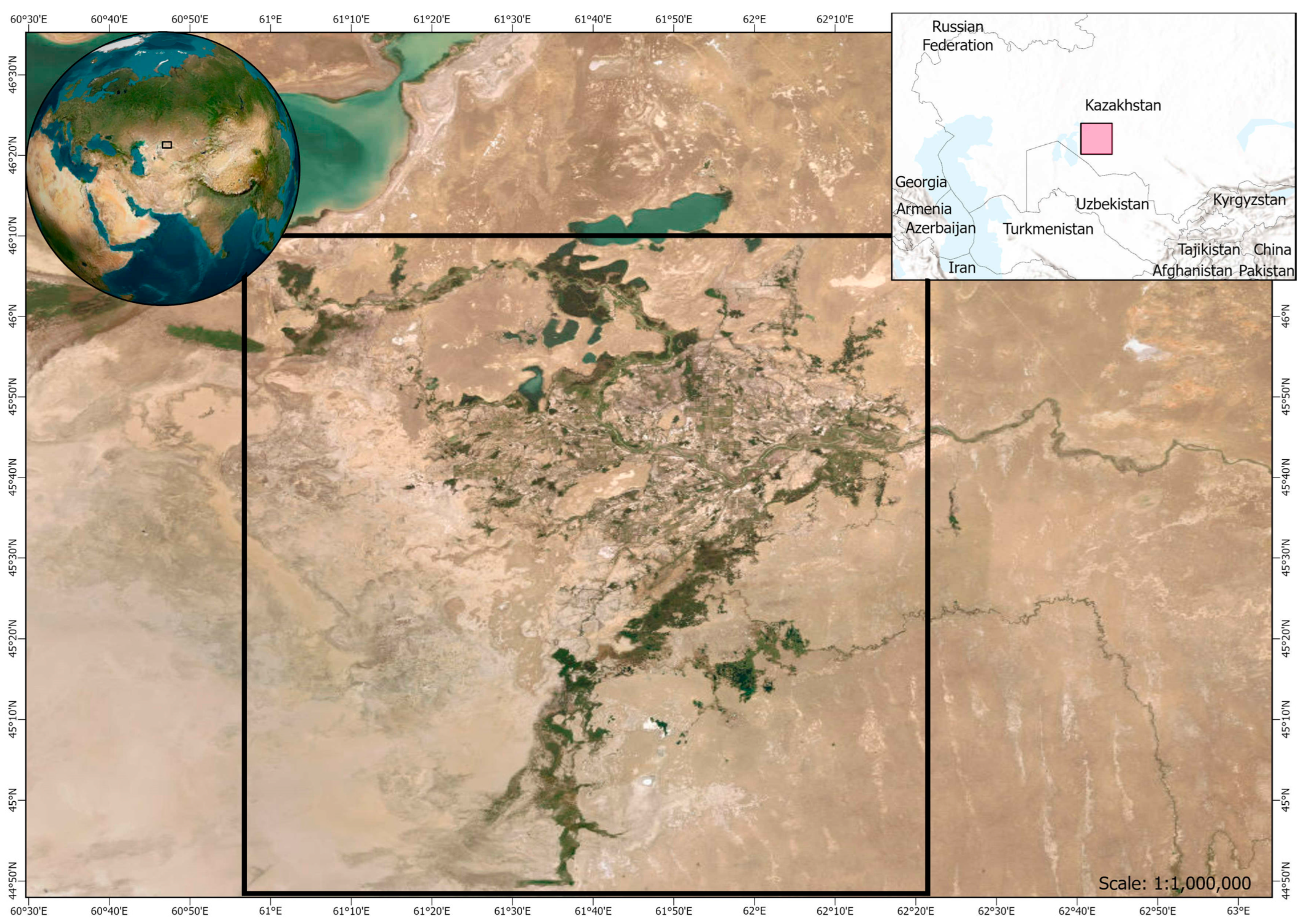
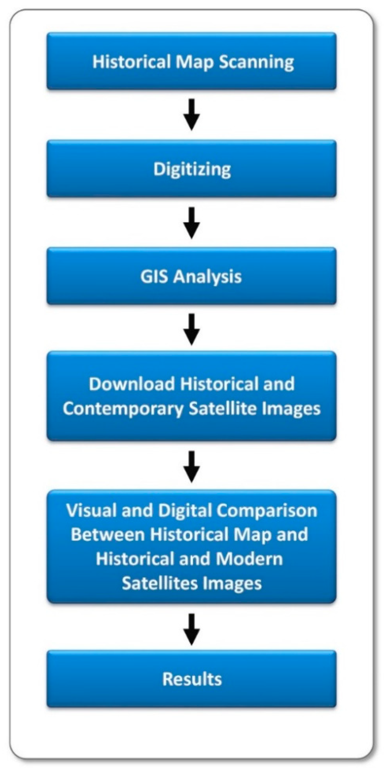
2. Methods and Materials

2.1. Qualitative Historical Data

The qualitative method is based on environmental, historical, discursive approaches combined with the content analysis method of primary historical sources, which isolate and detect different geographical features and descriptions in primary historical sources and the context they were used in [32,33,34,35,36]. Historical environmental data were compiled from reports of scientific surveys from the 19th and 20th centuries, from primary historical sources of Tsarist Russia, the British Empire and the USSR, isolating historical data describing the hydrography, irrigation and land use and land cover (LULC) of the SD [22,36,37,38,39].

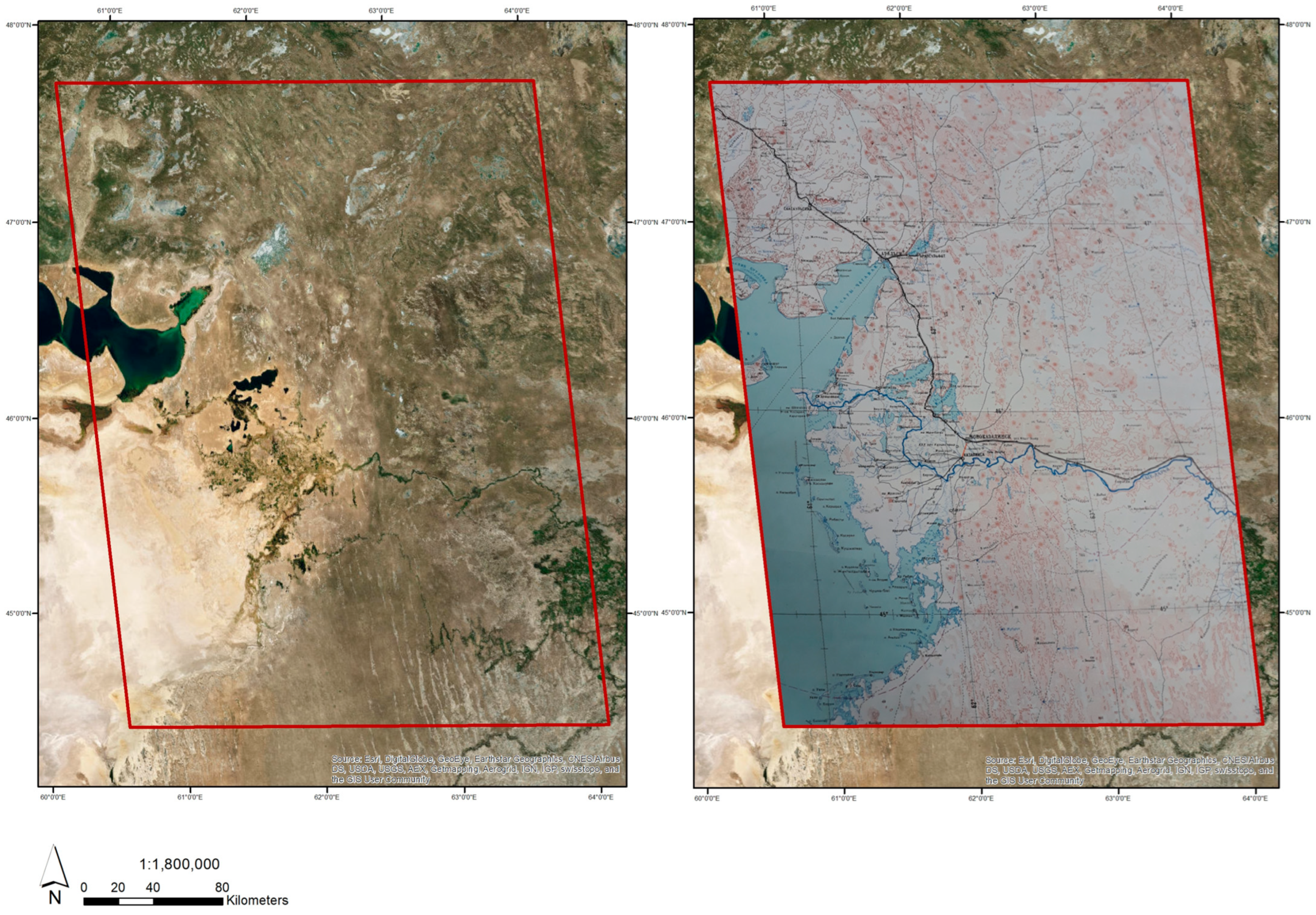
2.2. Analysis of Historical Maps
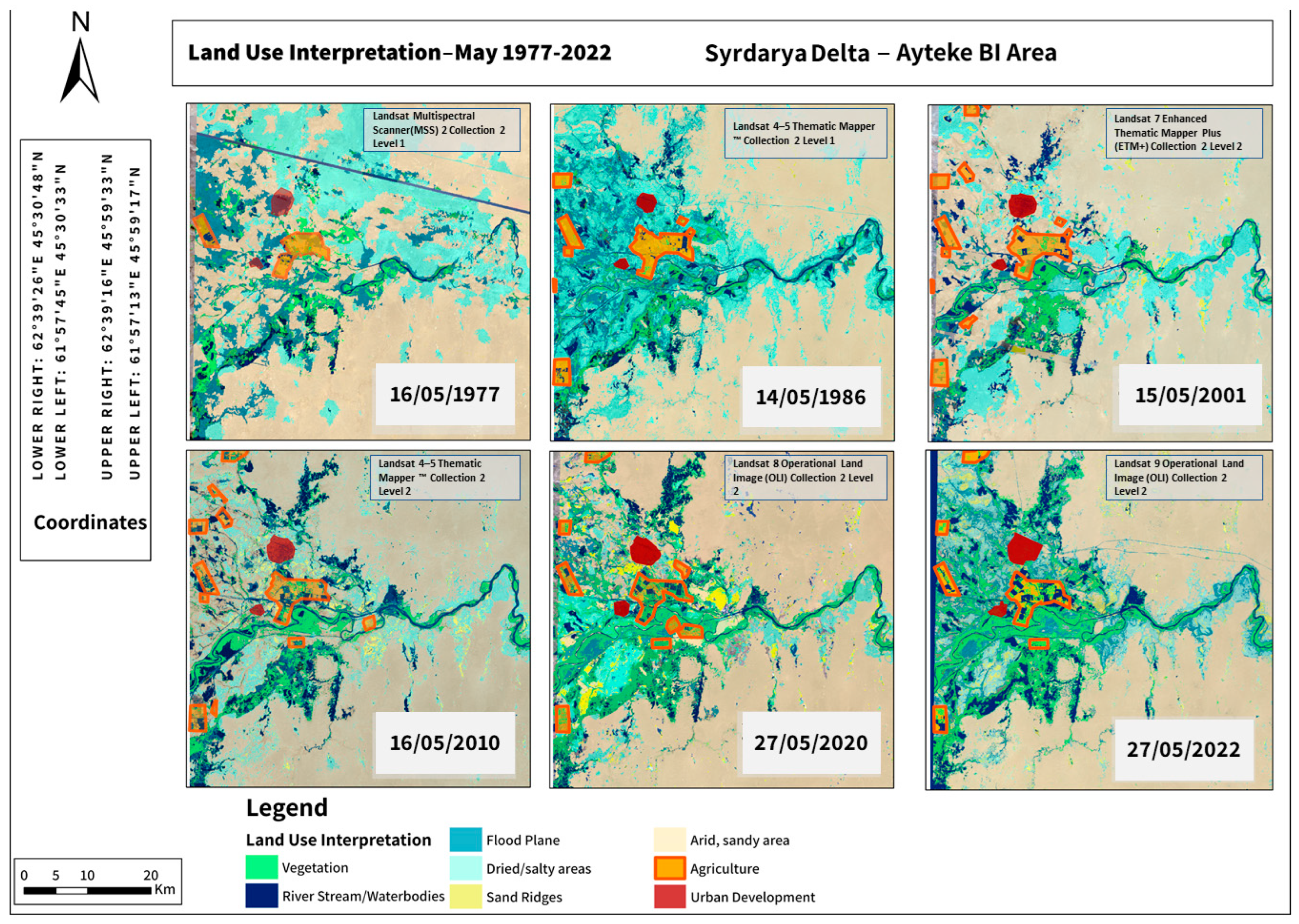
Historical maps can provide a description of a given historical landscape, providing crucial data, especially regarding historical eras when aerial photography and satellite images were either unavailable or of a very low resolution [35,40,41].
The methodology used to analyze the 19th century historical map and the Soviet Army maps from the second half of the 20th century included several stages.
First, the historical map was scanned and georeferenced for visual comparison and analysis. The Soviet Army maps were also scanned and georeferenced in order to create a digital copy with ArcGIS, providing historical geographic content in GIS environment. Once georeferenced, the historical Soviet Army map was compared and added to the historical satellite images, thus being used to create time series images and data of LULC in the SD.
Second, historical materials were selected and gathered, especially historical exploration reports along with historical and contemporary satellite images, in order to correlate between natural and anthropogenic changes detected in the landscape based on GIS analysis, and a visual comparison was conducted in order to understand the contribution that these historical materials provide.
Lastly, data from historical maps were organized in digital databases and tables, with features such as hydrology, geomorphology, water bodies, vegetative cover, human settlement and agriculture. The results are presented in units of meters or kilometers in graphs and in numerical tables. A flowchart of the research methodology is presented in Figure 2.

2.3. Remote Sensing

The ability to investigate planet earth from space with different perspectives using high-resolution cameras that can observe and analyze different electromagnetic spectra opens broad opportunities for scientific research, and it is a tool that develops constantly [40,42,43,44,45]. Satellite technologies enable the analysis of vast geographical areas from broader perspectives, which ground surveys cannot achieve [43,46,47] By using remote-sensing techniques, we can study and analyze a landscape from a distance without direct contact. Remote-sensing tools provide the ability to investigate and analyze minerals, vegetative cover, human settlements, water bodies, roads, soil qualities and changes in a selected area [40,45,48,49].
Land use and land cover assessments are analyzed using remote-sensing data. The ideal is to use high-resolution sensor images, and historical satellite images can be a challenge as a result of resolution [42,50]. However, examining the LULC patterns over a scale of time, focusing on elements large enough so as not to be limited to high resolution, can provide a crucial database regarding LULC. The initial stages of landscape and land use interpretation in the research area combined several automatic and semi-automatic procedures [46,51]. The study was conducted in a specific region of the Syrdarya Delta and analyzed selected changes in the natural and anthropogenic landscapes during a period of several decades [50,52]. Prior to the classification and interpretation stages, data collection was performed. Six Landsat satellite images were downloaded from the USGS Earth Explorer database https://earthexplorer.usgs.gov accessed in 25 November 2022 [42,50,53]. The selected temporal framework focused on May to also detect and analyze vegetative cover changes. Observation images were selected for the following dates:
-
16 May 1977;
-
14 May 1986;
-
15 May 2001;
-
16 May 2010;
-
27 May 2020;
-
27 May 2022.
Each image that was downloaded had a spatial resolution of 25 m. ArcGIS Pro 3.1 software was employed to conduct the analysis, which consisted of the following sequential stages:
  • Georeferencing of Landsat satellite images for the study area.
  • Preliminary unsupervised image classification in order to identify landscape clusters, including built areas, agricultural land, wet zones and dry zones.
  • Application of specific features to delineate entities from the identified clusters:
    • Normalized Difference Vegetation Index (NDVI) for identification of vegetated areas and their changes in the SD.
    • Normalized Difference Water Index (NDWI) for delineation of water bodies in the SD.
    • Normalized Difference Built-up Index (NDBI) for identification and analysis of built areas in the SD.
    • Normalized Difference Moisture Index (NDMI) for differentiation between crops and other vegetation identified through NDVI.
  • Manual interpretation in specific regions, particularly in agricultural areas.
  • Calculation of areal metrics and comparative data analysis.
  • Production of spatial outputs.
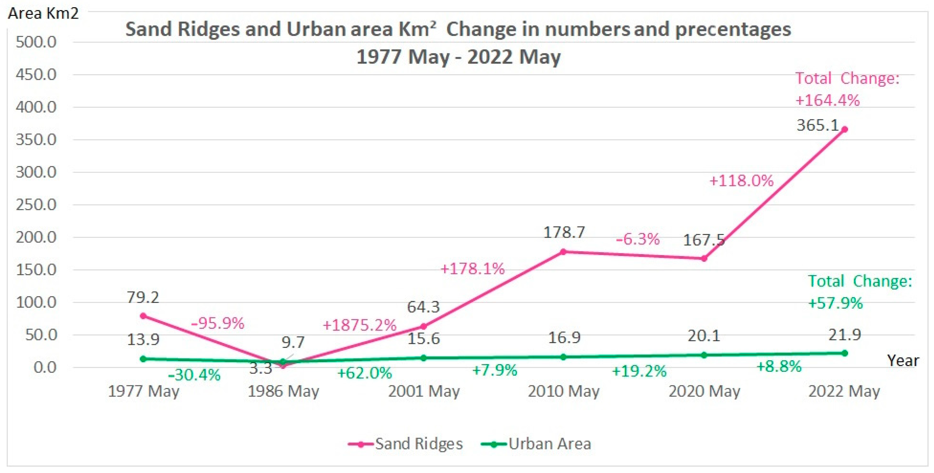
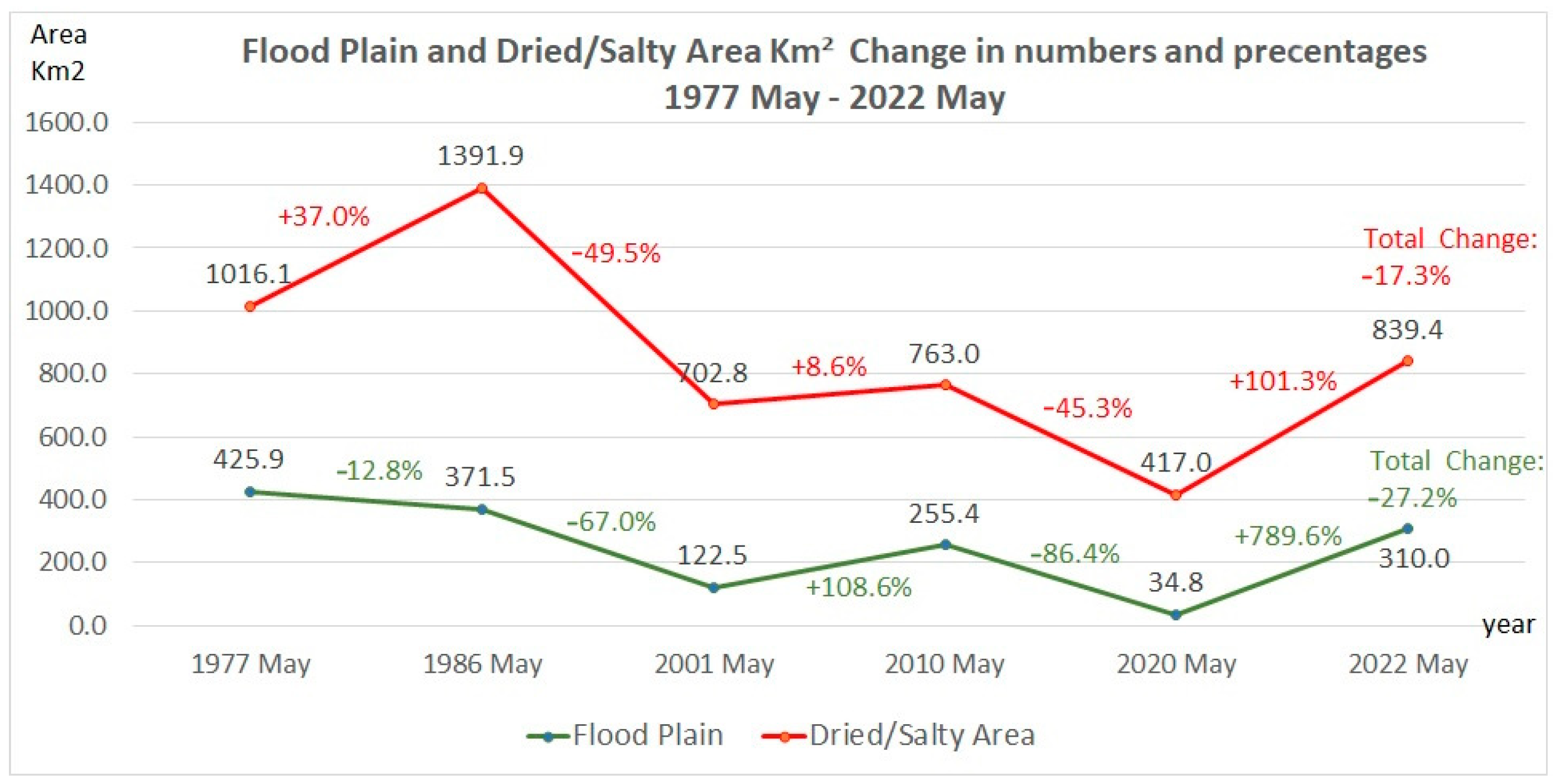
This research provided a comprehensive analysis of the landscape and land use changes in the SD over a 45-year period (1977–2022). Through the systematic application of remote-sensing techniques and geospatial analysis, several significant findings were discovered, which are presented and explained in Section “Environmental History of the Syrdarya Delta During the USSR and Since Then”.

3. Results

The results of this study show a slow and careful analysis of 19th and 20th century historical sources, compared and contrasted with Soviet and modern contemporary sources using Arc GIS Pro 3.1 and remote-sensing tools, exposing the effects of humans on the SD. Our analysis results show that the SD changed in aspects of hydrography, LULC and settlements over the studied period. The historical map from the 19th century combined with the historical exploration reports show that water streams were different in size and hydrography and that the SD irrigation and LULC until the Soviet period mainly comprised traditional systems and did not allow agricultural activity on a massive, industrial level. The GIS and remote-sensing analysis of Soviet Army and historical maps of the SD indicates different levels of mostly anthropogenic influences on SD hydrography and landscapes. The analysis indicates an increase, especially in vegetative cover and in water bodies, in comparison between the historical and more current years: 1980, 2001, 2010 and 2022. The analysis results indicate an increase of 57.9% in the urban area in the SD between May 1977 and May 2022 and a decrease of 95.9% in sand ridges until May 1986 during the Soviet period, probably as a result of the spread of vegetation in the SD covering the sand ridges. The results of this study also indicate an increase in the size of flood plains and dried and salty areas between 1977 and 1986 during the Soviet era, with an obvious decrease from 2001 until 2022.

4. Discussion

In this section, analyses of historical written reports by the Russian scientist and explorer Lev Semyonovich Berg (1876–1950) are analyzed and presented in the environmental historical context [54,55,56]. Lev Berg was born in 1876 in Bessarabia, which was then part of Tsarist Russia and today lies in Moldova [57]. Berg, a geographer and zoologist, surveyed and explored CA landscapes, focusing on the Aral Sea and its deltas: the AD and SD [20,38,58,59].
For his research on the Aral Sea, published as a book in Russian and later translated into English, Berg was awarded a doctoral degree in 1908 [20]. His research was sponsored initially by Tsarist Russia and later, after the Communist Revolution, by the USSR [57]. From the 1940s until his death in 1950, Berg served as president of the Geographical Society in the USSR [57].
The second explorer of the SD was Herbert Wood, an explorer sent by the British Empire who surveyed the Aral Sea, Amudarya Delta and SD [25].
The importance of the Berg expedition and its findings is explained in a review of his book about the Aral Sea translated into English from 1911:
“Mr. L. Berg’s book appears as a first attempt to give us detailed description of one of the largest interior water areas in Russia from physical and geographical point of view, not so much in the form of a compilation, but principally as a study based on his own observations and exploration. The book is therefore to be welcomed; and it is bound to occupy a foremost place among Russian limnological works” [60] (Markov, 1911, p. 515).
In his book, Berg analyzed different survey reports written by previous, mostly Russian, explorers of the Aral Sea and SD [20,53,61,62,63]. He also compared his own findings with the notes from earlier expeditions, such as those of General Alexey Boutakoff, a Tsarist Russia admiral who also explored the Aral Sea and its deltas between 1840 and 1860 [21,27,53,64,65].
Berg writes in his report that when he explored the SD between 1899 and 1906, “there were two main water streams, and between these two main large water streams in the delta exists intense vegetative cover on the landscapes of the Syrdarya Delta” [53] (Berg, 1908, p. 110). After measuring sedimentation mobilization of the Syrdarya River, Berg’s measurement results indicated, as he mentions, an average of 850 g of solid sediments per cube of water [53] (Berg, 1908, p. 127), presenting the water stream speed and its ability to transport sediments in the late 19th and early 20th centuries, which constitutes important historical hydrological information [53] (Berg, 1908, pp. 105–110). Berg also mentions in his book that an expedition that had surveyed the landscape of the SD between 1820 and 1825 describes a water stream that no longer exists in his time, indicating the dynamic nature of the delta region [53], (Berg, 1908, p. 128).
Berg’s report provides evidence on the dynamic hydrography and morphology of the SD in the late 19th and early 20th centuries before the intense policies implemented by the USSR in the SD [1,16,31,66,67]. As discussed above, the SD, located in a semi-arid and arid climate, is a very dynamic landscape, with a sensitive ecological system [9,31,68].
In Figure 3 and Figure 4, a visual analysis reveals the SD before the desiccation of the Aral Sea, with the settlements on its shore and in its delta, along with the water streams hydrography in the SD. Parallel to the historical map, a careful reading of Berg’s book about the SD provides important environmental historical data to understand the SD environment and geography during the Tsarist Russia period before it was transformed by the USSR [1]. Based on his measurements and surveys, Berg describes in his book (1908) that between 1899 and 1906, the SD contained two main water streams—a western one and a northern one—between which there was intensive vegetative cover [69] (Berg, 1908, p. 110). The SD, according to Berg’s report, is surrounded with a sediment belt 60–80 m wide [69] (Berg, 1908, p. 110). A comparison between Berg’s measurements and written report and descriptions of other historical and modern sources is presented later in this section, revealing the changes that occurred in the SD in the studied period.
The second explorer whose exploration reports regarding the SD this study refers to is Herbert Wood, an explorer sent by the British Empire who surveyed the Aral Sea, Amudarya Delta and SD [25]. Wood describes and explains in his report the evaporation percentage in the Aral Sea [25] (Wood, 1876, p. 404), warning that manipulating the two rivers of Amudarya and Syrdarya will dry out the Aral Sea and create severe damage to the local environment, including to its two deltas: the Amudarya Delta and SD [25] (Wood, 1876, p. 405). Wood also documented the amounts and types of land use and landscape management in the SD during the 1870s:
“I am not aware that the limited number of irrigation canals which exists on the lower courses of the Syr have their heads dammed and their beds cleared of deposit… the difference of treatment probably results from the irrigation on the lower Syr being on a much less extensive scale and unmethodical; and is also perhaps due to the different ethnic character of the respective populations, who have inherited different traditions from their ancestors” [25] (Wood, 1876, p. 397).
Wood emphasized the difference in irrigation systems, types and amounts of landscape management in the SD compared to what he found in his survey of the Amudarya Delta. Wood mentions the differences between the cultures and populations of these two deltas [25] (Wood, 1876, p. 397), noting that in the SD, agriculture is less intense than in the Amudarya Delta and that the traditional irrigation techniques used in the SD are different [25] (Wood, 1876, p. 397). This is an important detail to remember when analyzing the environmental history of the SD during the Soviet period between 1920 and 1991, when both the Amudarya Delta and the SD were governed by one single and centralized Soviet regime that applied the same irrigation policies and attitudes toward their environments [1,25,70,71,72,73].
To recap, the following is a summary of the environmental history of the SD until the USSR period.
The SD had a rich history until the 19th century. Throughout most of its history, human settlement and agriculture were based mainly on traditional irrigation systems and approaches. The SD was settled by different local rulers and tribes, without massive irrigation and cultivation or intense industrialized processes.
The ecological and hydrographical systems of the SD, like those of other deltas, are dynamic and sensitive to natural and anthropogenic pressure. This fact was recognized and mentioned by various explorers, such as Tsarist Russian and later Soviet Berg and British Wood, in the late 19th and early 20th centuries.
The expeditions and explorers sent to the SD and sponsored by Tsarist Russia and the British Empire described the natural resources and mentioned the potential of the SD to be used and developed by humans to their benefit.
The exploration of the SD during the 19th century was motivated not only by the ambition to explore unknown geographical landscapes and expand the scientific knowledge of them, but mainly by economic and political interests to expand and benefit Tsarist Russia and the British Empire through explorers, attempts to understand the potential of the SD to be used for their needs.

Environmental History of the Syrdarya Delta During the USSR and Since Then

After the Communist Revolution (1917–1923) and the establishment of the USSR, with its full control over the SD as well as other large parts of Central Asia [1,40,62,74,75,76] a crucial need emerged for the Soviet regime to develop and promote a self-sufficient agriculture and industrial abilities in the SD, as in other landscapes in CA [5,77,78,79,80,81,82]. Parallel to the construction of massive water irrigation systems to manipulate water sources in the naturally limited water supply in CA, like the Syrdarya River for agriculture [4,25,81,83], the rapid transformation of SD aspects of LULC and its hydrography in a short time during the Soviet era between the 1920s and 1991 accelerated desertification, alongside other environmental problems, such as water shortage and soil salinization within the SD [18,51,57,79,84,85,86].
Parts of these phases can be reconstructed and observed using historical materials, such as maps and historical expeditionary reports from the Soviet era [1,55,63,86,87,88,89].
In this section, various sources created by the USSR as part of its formerly classified military mapping program were used to analyze the hydrography and LULC of the SD and reconstruct the historical phases in landscape changes in their historical context [12,38,89,90,91,92,93,94,95].
Figure 5 and Figure 6 present the SD and the northern part of the Aral Sea in a 1978 Soviet Army map layered on a satellite image from 5 July 2019 for visual comparison. Under the “Five-Year Plan” and related policies, the Aral Sea was seen by the central regime of the USSR as an “unproductive” water body, as documented in various Soviet sources [4,27]. Drying out the Aral Sea was a price that the USSR was consciously willing to pay for the development of Central Asia’s agriculture to benefit from [4,59,96]. The ideological view of the regime regarding both the role of science in contributing to the human potential and the Marxist assumption that society should be industrialized under the ownership of the working class, as part of a historical process that would spread communism worldwide, led to these ambitious social and natural engineering policies in the SD [1,4,51,71,97]. These details are vital in understanding the historical context of the extreme anthropogenic environmental changes in the SD, including the almost complete drying out of the Aral Sea [4,12,44,82,85,98].
The GIS and remote-sensing analysis of Soviet Army historical maps indicates different levels of mostly anthropogenic influences on the hydrography and landscapes of the SD [8,12]. The fact that the drastic changes in SD LULC and hydrography were accelerated during the Soviet era can assist in explaining, from environmental historical perspectives, the results and impacts of documented Soviet policies in the SD, with the Soviet attempt to increase agriculture and use the SD as an agricultural supplier, and the impact of such policies and practices on various natural systems within the SD [1,8,13,61,93,100]. The USSR’s water management in the SD had an extreme impact on the local environment, as Figure 5, Figure 6 and Figure 7 reveal. The intensity and amounts of hydrographic and LULC interventions in the SD increased, indicating that most of the landscape and hydrological changes in the SD in the Soviet era are a direct result of anthropogenic causes, mostly as a result of the USSR’s policies in its attempt to transform large parts of arid CA, the SD among them, into massive agricultural fields, turning it into a significant crop supplier [1,73,78,83,100,101,102].
The GIS and remote-sensing analysis of Soviet Army and historical maps of the SD indicates different levels of mostly anthropogenic influences on the hydrography and landscapes of the SD [8,12]. The USSR’s water management in the SD had an extreme impact on the local environment, as Figure 5, Figure 6 and Figure 7 reveal. The intensity and amounts of hydrographic and LULC interventions in the SD increased, indicating that most of the landscape and hydrological changes in the SD in the Soviet era are a direct result of anthropogenic causes, mostly as a result of the USSR’s policies in its attempt to transform large parts of arid CA, among them the SD, into massive agricultural fields and turn CA into a crop supplier [1,78,83,92,101,103,104].
This part of the study used GIS and remote-sensing analysis methods [46] (He et al., 2015).
The analysis presented in Figure 8 indicates an increase in the size of flood plains and dried and salty areas between 1977 and 1986 during the Soviet era, with an obvious decrease from 2001 until 2022. It shows the differences in land use and irrigation amount approaches and intensities between the Soviet and the post-Soviet periods and emphasizes the anthropogenic impact on the SD.
The analysis of the historical and contemporary images of the SD also reveals increasing vegetative cover, as shown in Figure 9, where the SD is greener in the years 2010–2022 than in earlier years. There is a clear correlation between Soviet policies in the SD and the increase in the amounts of dried/salty areas. The following is observed in the analysis presented in Figure 9 below.
Between 1977 and 1986, during the USSR regime, there were more flood plains and dried/salty areas in the SD and surrounding lands as a direct result of the flooding irrigation methods used by the USSR to grow large amounts of crops in the SD.
Since 2001, there has been a reduction in the amounts of flood plains and dried/salty areas, alongside an increase in vegetative cover. Likewise, those years reveal the exposure of sand dunes, with a reduction in the amounts of vegetative cover on them.
The changes in the SD are presented above on the basis of varied historical materials, which help provide the environmental historical context to explain, in a broader way, the changes in the SD between 1977 and 2022—a period during which the area was under the Soviet regime and, following its collapse, a local independent rule.
The analysis indicates an increase, especially in vegetative cover and in water bodies, in comparison between the historical and more current years—1980, 2001, 2010 and 2022—as presented in Figure 8 and Figure 9. The LULC of the 1980s under the USSR regime changed in the last 40 years, especially in the aspects of vegetative cover and water bodies [19,80,93]. Notably, the regime changes between the 1980s and 2022 reflect a transition from USSR policy to the policy of independent Kazakhstan that now faces tensions with the countries that control the upstream of the Syrdarya River [12,105]. The analysis presents an increase in water bodies from May 1978 during the Soviet period—an increase that continues after the collapse of the Soviet regime in 1991. Parallel to this, there is a slight decrease in the Syrdarya Delta River’s main stream. In the following section, graphs of the analysis are presented in Figure 8 and Figure 9 and further explained.
The analysis results indicate an increase of 57.9% in the urban area in the SD between May 1977 and May 2022 and a decrease of 95.9% in sand ridges until May 1986 during the Soviet regime, probably as a result of the spread of vegetative cover in the SD covering the sand ridges. Subsequently, there is a constant increase from 1987 until 2022 in the amounts of sand ridges, as can be seen in Figure 10 [12,77,106]. This comprises a quantified analysis of different LULC in the SD between the Soviet era and the period after the USSR’s collapse in 1991.
The connection between the amounts of flood plains and the number of dried/salty areas is almost parallel, emphasizing the environmental damage the Soviet flood plains created in the SD.
As Figure 11 shows, between May 1977 and May 1986, there is an increase of 37% in the amounts of Dried /salty areas in the SD. Since May 1986, there is a decrease of 49.5%, as seen in the analysis; the decrease continues, and from May 2020, an increase is observed again.
The GIS analysis of Soviet Army historical maps integrated with historical and contemporary satellite images as presented in Figure 5, Figure 6, Figure 7, Figure 8 and Figure 9 indicates different levels of mostly anthropogenic influences on the hydrography and landscapes of the SD [8,93]. The USSR’s water management in the SD’s semi-arid and arid landscape had extreme repercussions for the local environment, as presented in Figure 11 and Figure 12. The hydrographic changes corresponded with intensive LULC changes, indicating that most of the hydrologic changes in SD landscapes that occurred in the 19th and 20th centuries [68] are a direct result of anthropogenic causes, mostly as a result of the USSR’s policies in its attempt to transform large parts of arid CA into massive agricultural fields and turn CA into a crop supplier [1,73,78,83,101].
The intense diversion and manipulation of water of the Syrdarya River for crop irrigation had, and still continue to have, a major impact on the landscape and soils of the SD, as presented above [11,15,103,107,108]. Indeed, SD landscapes and hydrology have been transformed by a massive and complicated net of irrigation canals, agricultural fields and transport roads [68,108]. The USSR’s water management in the SD promoted massive agricultural development of irrigation and agriculture policies, especially of rice and cotton [1,8,13]. However, the intense use of inefficient water systems in the semi-arid and arid landscape of the SD led to salinization of the soil and changed the numbers and sizes of settlements and agricultural fields compared with historical descriptions of the SD, as seen in Figure 8 and Figure 9 [4,13,109]. The ambitious plans and policies of the USSR for increasing agricultural production parallel to industrialization and social changes, combined with poor scientific understanding and ambitious bureaucratic planning, led to environmental problems, such as soil salinization, lack of water in areas in the delta, loss of biomass and a decrease in the productivity of soils in parts of the SD, as a result of inappropriate fertilizer use and inefficient water techniques, as shown by historical documentation [8,19,30,63,102].
The figures presented above of SD maps from Tsarist Russia, USSR Army maps and satellite images from 1977–2022, alongside the other primary historical sources about the SD quoted in the first part of this study [20,25], emphasize the transformation that the region of the SD experienced from the time of Tsarist Russia, through the USSR period and to the present [1,78,93]. Indeed, during the study years, the delta was transformed by a net of irrigation canals, transport roads, industrialization and increased settlement [8,13,68,93].

5. Summary and Conclusions

This case study, investigating historical materials about the SD from the 19th century compared with modern satellite images using remote-sensing analysis techniques and GIS analysis tools, presents the importance and the high value of the historical spatial data gathered from the 19th century during the Tsarist Russia era and the Soviet period. It demonstrates the ability to compare those data sources with historical and modern satellite images and to expand our understanding, from an environmental historical perspective, regarding the extent and the phases of changes in the SD between the 19th century and the present era, offering insights about the connection of these changes to historical circumstances, such as regime changes and subsequent policies, landscape management policies and socio-political needs. As presented in this study, the integration of written historical materials along with historical maps provides the possibility to reconstruct the former shoreline of the Aral Sea in the SD and demonstrate how Tsarist Russia and USSR historical maps can contribute to the environmental sciences.
The analysis of the dynamic nature of the SD environment and the drastic changes that took place in a short period along the historical time scale, between the 19th century and the present, reveals the environmental and landscape consequences of intense industrialization policies, especially during the Soviet period, in the SD. As the analysis of historical and contemporary materials from the 19th century through the present in this section reveals, the SD has a complex environmental history, and comprehending the changes caused by human intervention in the study area, transforming it from traditional agricultural use with the local traditional lifestyle of semi-nomads and traditional agriculture into industrial, intense irrigated landscape, is crucial for understanding the present environmental crisis and problems in the region. The impact on the SD landscape during the USSR’s collapse and at the end of its rule is clearly visible, with a reduction in the amounts of flooded plains and dry/salty areas when the irrigation extent and policies changed, emphasizing the role of the anthropogenic factor in SD changes.
This study argues that studying historical materials expands our understanding regarding the extent and types of disruptions in the SD ecological system.

Author Contributions

Methodology, L.O.; Validation, I.A.M.; Resources, Z.Z.; Writing—original draft, Z.Z.; Writing—review & editing, L.O. and I.A.M.; Supervision, I.A.M. All authors have read and agreed to the published version of the manuscript.

Funding

This research received no external funding.

Data Availability Statement

The original contributions presented in this study are included in the article. Further inquiries can be directed to the corresponding author.

Acknowledgments

The vital contribution of Vera Kaplan, Department of History, Cummings Center for Russian and East European Studies, Tel Aviv University, is kindly acknowledged. The authors would also like to thank Mark Shteyngauz, independent scholar, for his technical advice in remote sensing.

Conflicts of Interest

The authors declare no conflict of interest.

References

  1. Cameron, S. The Hungry Steppe: Famine, Violence, and the Making of Soviet Kazakhstan; Cornell University Press: Ithaca, NY, USA, 2018. [Google Scholar]
  2. Jelen, I.; Angelija, B.; Francesco, C. Geography of Central Asia; Springer International Publishing: Berlin/Heidelberg, Germany, 2020. [Google Scholar]
  3. Kindler, R. Stalin’s Nomads: Power and Famine in Kazakhstan; University of Pittsburgh Press: Pittsburgh, PA, USA, 2018. [Google Scholar]
  4. Micklin, P.P. The future Aral Sea: Hope and despair. Environ. Earth Sci. 2016, 75, 844. [Google Scholar] [CrossRef]
  5. Ermakhanov, Z.K.; Plotnikov, I.S.; Aladin, N.V.; Micklin, P. Changes in the Aral Sea ichthyofauna and fishery during the period of ecological crisis. Lakes Reserv. Res. Manag. 2012, 17, 3–9. [Google Scholar] [CrossRef]
  6. Golden, P. Central Asia in World History; Oxford University Press: Oxford, UK, 2011. [Google Scholar]
  7. Keating, J. “There are few plants, but they are growing, and quickly”: Foliage and the aesthetics of landscape in Russian Central Asia, 1854–1914. Stud. Hist. Gard. Des. Landsc. 2017, 37, 174–189. [Google Scholar] [CrossRef]
  8. Taltakov, I. The Syr Darya River- New ecological disaster in Central Asia. Acta Sci. Pol. Form. Circumiectus 2015, 14, 135–140. [Google Scholar] [CrossRef]
  9. Williams, M. Climate Change in Deserts: Past, Present and Future; Cambridge University Press: Cambridge, UK, 2014. [Google Scholar]
  10. Wood, F. The Silk Road; University of California Press: Berkeley, CA, USA, 2012. [Google Scholar]
  11. Khai, R.Y. Creation of system “Delta-Sea” as a basis of ecosystem approach to the management of large Aral Sea’s coastal zone. In Management and Sustainable Development of Coastal Zone Environments; Ramanathan, A.L., Bhattacharya, P., Dittmar, T., Prasad, M.B.K., Neupane, B.R., Eds.; Springer: Dordrecht, The Netherlands, 2010. [Google Scholar]
  12. Kuz’mina, Z.V.; Shinkarenko, S.S.; Solodovnikov, D.A. Main tendencies in the dynamics of floodplain ecosystems and landscapes of the lower reaches of the Syr Darya river under modern changing conditions. Arid. Ecosyst. 2019, 9, 226–236. [Google Scholar] [CrossRef]
  13. Zhang, W.; Ma, L.; Abuduwaili, J.; Ge, Y.; Issanova, G.; Saparov, G. Hydrochemical characteristics and irrigation suitability of surface water in the Syr Darya River, Kazakhstan. Environ. Monit. Assess. 2019, 191, 572. [Google Scholar] [CrossRef]
  14. Andrianov, B.V. The history of economic development in the Aral Region and its influence on the environment. GeoJournal 1995, 35, 11–16. [Google Scholar] [CrossRef]
  15. Féaux de la Croix, J.; Arzhantseva, I.; Dağyeli, J.; Dubuisson, E.M.; Härke, H.; Penati, B.; Wooden, A. Roundtable studying the Anthropocene in Central Asia: The challenge of sources and scales in human–environment relations. Cent. Asian Surv. 2022, 41, 180–203. [Google Scholar] [CrossRef]
  16. Micklin, P.P. Efforts to revive the Aral Sea. In The Aral Sea; Springer: Berlin/Heidelberg, Germany, 2014. [Google Scholar]
  17. Mitrofanov, I.V.; Mamilov, N.S. Fish diversity and fisheries in the Caspian Sea and Aral-Syr Darya basin in the Republic of Kazakhstan at the beginning of the 21st Century. Aquat. Ecosyst. Health Manag. 2015, 18, 160–170. [Google Scholar] [CrossRef]
  18. Penati, B. Explorations in the Social History of Modern Central Asia (19th-Early 20th Century); Brill: Leiden, The Netherlands, 2013. [Google Scholar]
  19. Zhou, Y.; Zhang, L.; Fensholt, R.; Wang, K.; Vitkovskaya, I.; Tian, F. Climate contributions to vegetation variations in Central Asian drylands: Pre-and post-USSR collapse. Remote Sens. 2015, 7, 2449–2470. [Google Scholar] [CrossRef]
  20. Berg, L.S. The Aral Sea: An experience of physics-geographic monography. Izv Turkestanskogo Otd Rus. Geogr Obs. 1908, 5, 580. [Google Scholar]
  21. Boutakoff, A. Survey of the Sea of Aral. J. R. Geogr. Soc. 1853, XXIII, 93–101. [Google Scholar] [CrossRef]
  22. Lansdell, H. Russian Central Asia: Including Kuldja, Bokhara, Khiva and Merv; Sampson Low, Marston, Searle and Rivington: London, UK, 1885; Volume 2. [Google Scholar]
  23. Popova, I.F. (Ed.) Russian Explorations in Central Asia at the Turn of the 20th Century; Slavia: Prague, Czech, 2008. [Google Scholar]
  24. Walker, D. The Pundits: British Exploration of Tibet and Central Asia; Kentucky University Press: Lexington, KY, USA, 2004. [Google Scholar]
  25. Wood, H. Notes on the Lower Amú-darya, Syr-darya and Lake Aral, in 1874. J. R. Geogr. Soc. Lond. 1876, 45, 367–413. [Google Scholar] [CrossRef]
  26. Zonn, I.S.; Kosarev, A.N. History of investigation and exploration of the Aral Sea. In The Aral Sea Environment, The Handbook of Environmental Chemistry; Kostianoy, A., Kosarev, A., Eds.; Springer: Berlin/Heidelberg, Germany, 2010; Volume 7, pp. 11–23. [Google Scholar]
  27. Peterson, M. Pipe Dreams—Water and Empire in Central Asia’s Aral Sea Basin; Cambridge University Press: Cambridge, UK, 2019. [Google Scholar]
  28. Becker, S. Russia’s Protectorates in Central Asia: Bukhara and Khiva, 1865–1924; Routledge: Oxfordshire, UK, 2004; Volume 5. [Google Scholar]
  29. Edney, M.H. Mapping an Empire: The Geographical Construction of British India, 1765–1843; University of Chicago Press: Chicago, IL, USA, 2009. [Google Scholar]
  30. Keating, J. On Arid Ground: Political Ecologies of Empire in Russian Central Asia; Oxford University Press: Oxford, UK, 2022. [Google Scholar]
  31. Morrison, A. The Russian Conquest of Central Asia: A Study in Imperial Expansion, 1814–1914; Cambridge University Press: Cambridge, UK, 2021. [Google Scholar]
  32. Fuchs, R.; Verburg, P.H.; Clevers, J.G.P.W.; Herold, M. The potential of old maps and encyclopedias for reconstructing historic European land cover/use change. Appl. Geogr. 2015, 59, 43–55. [Google Scholar] [CrossRef]
  33. Gaddis, J.L. The Landscape of History: How Historians Map the Past; Oxford University Press: Oxford, UK, 2002. [Google Scholar]
  34. Gregory, I.N. A Place in History: A Guide to Using GIS in Historical Research; Oxbow: West Palm Beach, FL, USA, 2002. [Google Scholar]
  35. Hamre, L.N.; Domaas, S.T.; Austad, I.; Rydgren, K. Land-cover and structural changes in a Western Norwegian cultural landscape since 1865, based on an old cadastral map and field survey. Landsc. Ecol. 2007, 22, 1563–1574. [Google Scholar] [CrossRef]
  36. Levin, E.E.; Gasith, A. Decline of wetland ecosystems in the coastal plain of Israel during the 20th century: Implications for wetland conservation and management. Landsc. Urban Plan. 2009, 92, 220–232. [Google Scholar] [CrossRef]
  37. Börjeson, L. Using a historical map as a baseline in a land-cover change study of Northeast Tanzania. Afr. J. Ecol. 2009, 47 (Suppl. S1), 185–191. [Google Scholar] [CrossRef]
  38. Cruickshank, J.L. Military mapping by Russia and the Soviet Union. In The History of Cartography, v. 16: Cartography in the Twentieth Century; Monmonier, M., Ed.; University of Chicago Press: Chicago, IL, USA, 2015; pp. 932–942. [Google Scholar]
  39. Gregory, I.N.; Eli, P.S. Historical GIS; Cambridge University Press: Cambridge, UK, 2007. [Google Scholar]
  40. Goodchild, M.F. Prospects for a space–time GIS: Space-time integration in geography and GIScience. Ann. Assoc. Am. Geogr. 2013, 103, 1072–1077. [Google Scholar] [CrossRef]
  41. Gregory, I.N.; Dorling, D.; Southall, H.R. A century of inequality in England and Wales using standardized geographical units. Area 2001, 33, 297–311. [Google Scholar] [CrossRef]
  42. Gheyle, W.; Trommelmans, R.; Bourgeios, J.; Goossens, R.; Bourgeios, I.; Wulf, A.D.; Willems, T. Evaluating CORONA: A case study in the Altai Republic (South Siberia). Antiquity 2004, 78, 391–403. [Google Scholar] [CrossRef]
  43. Maman, S. Mobility and Stability of the Central Asian Sand Seas (Karakum and Kyzylkum): A Study by Remote Sensing and GIS; Ben-Gurion University of the Negev: Beersheba, Israel, 2012. [Google Scholar]
  44. Narama, C. The Lake-Level Changes in Central Asia During the Last 1000 years Based on Historical Map. Proceedings of International Workshop on “Reconceptualizing Cultural and Environmental Change in Central Asia: An Historical Perspective on the Future”, 2010, pp. 11–27. Available online: https://www.chikyu.ac.jp/ilipro/page/18-publication/workshop-book/workshop-book_individual%20files/1-2_Narama.pdf (accessed on 5 March 2025).
  45. Zhang, L.; Weng, Q.; Shao, Z.F. An evaluation of monthly impervious surface dynamics by fusing Landsat and MODIS time series in the Pearl River Delta, China, from 2000 to 2015. Remote Sens. Environ. 2017, 201, 99–114. [Google Scholar] [CrossRef]
  46. He, F.; Li, M.; Li, S.; Xiao, R. Comparison of changes in land use and land cover in China and the USA over the past 300 years. J. Geogr. Sci. 2015, 25, 1045–1057. [Google Scholar] [CrossRef]
  47. Liu, Y.; Yue, T.; Jiao, Y.; Zhao, N.; Zhao, M. Temperature changes in the Heihe River Basin based on high accuracy surface modelling. Meteorol. Appl. 2019, 26, 720–732. [Google Scholar] [CrossRef]
  48. Ben-Dor, E.; Chabrillat, S.; Demattê, J.A.M.; Taylor, G.R.; Hill, J.; Whiting, M.L. Using imaging spectroscopy to study soil properties. Remote Sens. Environ. 2009, 113 (Suppl. S1), S38–S55. [Google Scholar] [CrossRef]
  49. Maman, S.; Orlovsky, L.; Blumberg, D.G.; Berliner, P.; Mamedov, B. A landcover change study of takyr surfaces in Turkmenistan. J. Arid. Environ. 2011, 75, 842–850. [Google Scholar] [CrossRef]
  50. Jiang, H. Stories remote sensing images can tell: Integrating remote sensing analysis with ethnographic research in the study of cultural landscapes. Hum. Ecol. 2003, 31, 215–232. [Google Scholar] [CrossRef]
  51. Zhang, C.; Lu, D.; Chen, X.; Zhang, Y.; Maisupova, B.; Tao, Y. The spatiotemporal patterns of vegetation coverage and biomass of the temperate. deserts.in Central Asia and their relationships with climate controls. Remote Sens. Environ. 2016, 175, 271–281. [Google Scholar] [CrossRef]
  52. Yang, Y.; Zhang, S.; Yang, J.; Xing, X.; Wang, D. Using a cellular Automata-Markov model to reconstruct spatial land-use patterns in Zhenlai county, Northeast China. Energies 2015, 8, 3882–3902. [Google Scholar] [CrossRef]
  53. Andreyev, A.I.; Baskhanov, M.; Yusupova, T. The Quest for Forbidden Lands: Nikolai Przhevalskii and His Followers on Inner Asian Tracks; Brill: Leiden, The Netherlands, 2018. [Google Scholar]
  54. Isenberg, A. The Oxford Handbook of Environmental History; Oxford University Press: Oxford, UK, 2014. [Google Scholar]
  55. Josephson, P.; Dronin, N.; Mnatsakanian, R.; Cherp, A.; Efremenko, D.; Larin, V. An Environmental History of Russia; Cambridge University Press: Cambridge, UK, 2013. [Google Scholar]
  56. Zokirov, B.I.U. Works of foreign tourists visiting Central Asia in the XIX century as a source in the study of regional ethnotoponyms. Curr. Res. Joarnal Hist. 2021, 2, 33–38. [Google Scholar] [CrossRef]
  57. Shaw, D.J.; Oldfield, J.D. Soviet geographers and the great patriotic war, 1941–1945: Lev Berg and Andrei Grigor’ev. J. Hist. Geogr. 2015, 47, 40–49. [Google Scholar] [CrossRef]
  58. Erkinov, A. The conquest of Khiva from a poet’s point of view. In Looking at the Colonizer: Cross-Cultural Perceptions in Central Asia and the Caucasus, Bengal, and Related Areas; Eschment, B., Harder, H., Eds.; Ergon Verlag: Würzburg, Germany, 2004; pp. 91–115. [Google Scholar]
  59. Saiko, T. Environmental Crisis; Routledge: Oxfordshire, UK, 2014. [Google Scholar]
  60. Markov, E.; Berg, L. The Sea of Aral. Geogr. J. 1911, 38, 515–519. [Google Scholar] [CrossRef]
  61. Beysenova, A.S. Rol’ russkikh uchenykh v poznanii prirody Kazakhstana (s drevneyshikh vremen do serediny XX veka). In The Role of Russian Scientists in the Knowledge of the Nature of Kazakhstan (from Ancient Times Until the Middle of the 20th Century); Mektep: Almaty, Kazakhstan, 2011. (In Russain) [Google Scholar]
  62. Keller, S. Russia and Central Asia—Coexistence, Conquest, Convergence; University of Toronto Press: Toronto, ON, Canada, 2020. [Google Scholar]
  63. Pianciola, N. Cossacks and Sturgeons: Fisheries, Colonization, and Science around the Aral Sea (1873–1906). J. Econ. Soc. Hist. Orient 2019, 62, 626–673. [Google Scholar] [CrossRef]
  64. Boutakoff, A.; Michell, J. The Delta and Mouths of the Amu-Daria, or Oxus. J. R. Geogr. Soc. Lond. 1867, 37, 152–160. [Google Scholar] [CrossRef]
  65. Boutakoff, A. Svedinya ob expedizie, snaryjonoy dlya opisi Aral’skoe more v 1848 g. Vestnik Russk. Geogr. Obshchestva 1853, VII, 1–7. (In Russian) [Google Scholar]
  66. Penati, B. The Cotton Boom and the Land Tax in Russian Turkestan (1880s–1915). Krit. Explor. Russ. Eurasian Hist. 2013, 14, 741–774. [Google Scholar] [CrossRef]
  67. Zhang, M.; Luo, G.; De Maeyer, P.; Cai, P.; Kurban, A. Improved atmospheric modelling of the oasis-desert system in Central Asia using WRF with actual satellite products. Remote Sens. 2017, 9, 1273–1300. [Google Scholar] [CrossRef]
  68. Wuepper, D.; Borrelli, P.; Mueller, D.; Finger, R. Quantifying the soil erosion legacy of the Soviet Union. Agricultural Systems 2020, 185, 102940. [Google Scholar] [CrossRef]
  69. Berg, L.S. Aral’skoe More; MM Stasyulevicha: Saint Petersburg, Russian, 1908. [Google Scholar]
  70. Abuduwaili, J.; Issanova, G.; Saparov, G. Hydrology and Limnology of Central Asia; Springer: Berlin/Heidelberg, Germany, 2018. [Google Scholar]
  71. Fierman, W. Soviet Central Asia; Routledge: Oxfordshire, UK, 2019. [Google Scholar]
  72. Keating, J. Amid the horrors of nature: ‘dead’ environments at the margins of the Russian empire. In Empty Spaces: Perspectives on Emptiness in Modern History; Keating, J., Campbell, C.J., Giovine, A., Eds.; University of London Press: London, UK, 2019; pp. 33–58. [Google Scholar]
  73. Peterson, M.U.S. to USSR: American experts, irrigation, and cotton in Soviet Central Asia, 1929–1932. Environ. Hist. 2016, 21, 442–466. [Google Scholar] [CrossRef]
  74. Breyfogle, N.B. Toward an environmental history of tsarist Russia and the Soviet Union. In Eurasian Environments: Nature and Ecology in Imperial Russian and Soviet History; University of Pittsburgh Press: Pittsburgh, PA, USA, 2018; pp. 3–20. [Google Scholar]
  75. Kent, A.J.; Davies, J.M. Hot geospatial intelligence from a Cold War: The Soviet military mapping of towns and cities. Cartogr. Geogr. Inf. Sci. 2013, 40, 248–253. [Google Scholar] [CrossRef]
  76. Li, Z.; Chen, Y.; Li, W.; Deng, H.; Fang, G. Potential impacts of climate change on vegetation dynamics of Central Asia. J. Geophys. Res.—Atmos. 2015, 120, 2045–2057. [Google Scholar] [CrossRef]
  77. Aralova, D.; Kariyeva, J.; Khujanazarov, T.; Toderich, K. Drought variability and land degradation in Central Asia: Assessment using remote sensing data and drought indices. In Vegetation of Central Asia and Environs; Egamberdieva, D., Öztürk, M., Eds.; Springer: Berlin/Heidelberg, Germany, 2018; pp. 15–47. [Google Scholar]
  78. Babaev, A.G. (Ed.) Desert Problems and Desertification in Central Asia; Springer: Berlin/Heidelberg, Germany, 2012. [Google Scholar]
  79. Cameron, S. Review of Imperial Desert Dreams. Cotton Growing and Irrigation in Central Asia, 1860–1991, by J. Obertreis. Jahrbücher Für Gesch. Osteur. 2020, 68, 569–571. Available online: https://www.jstor.org/stable/27073847 (accessed on 5 March 2025).
  80. Liastchenko, P.I. Technical Reconstruction and the Growth of Production in the Agriculture of the USSR. J. Farm Econ. 1934, 16, 539–543. [Google Scholar] [CrossRef]
  81. Miller, M. Khrushchev and the Development of Soviet Agriculture: The Virgin Land Programme 1953–1964. Int. Aff. 1977, 53, 498–499. [Google Scholar] [CrossRef]
  82. Penati, B. Adapting Russian technologies of power: Land-and-Water reform in the Uzbek SSR (1924–1928). Revolut. Russ. 2012, 25, 187–217. [Google Scholar] [CrossRef]
  83. Brite, E.B. The hydro social empire: The Karakum River and the Soviet conquest of Central Asia in the 20th century. J. Anthropol. Archaeol. 2018, 52, 123–136. [Google Scholar] [CrossRef]
  84. Arystambekova, D.; Thevs, N.; Tursumbayeva, M. Assessment of the hydroecological state of the Syrdarya Delta. Cent. Asian J. Water Res. 2019, 5, 29–41. [Google Scholar] [CrossRef]
  85. Josephson, P. War on Nature as Part of the Cold War. The Strategic and Ideological Roots of Environmental Degradation in the Soviet Union. In Environmental Histories of the Cold War; Cambridge University Press: Cambridge, UK, 2010; pp. 21–50. [Google Scholar]
  86. Lewis, R.A. (Ed.) Geographic Perspectives on Soviet Central Asia; Routledge: Oxfordshire, UK, 1992. [Google Scholar]
  87. Davies, J. Review of “Russian military mapping: A guide to using the most comprehensive source of global geospatial intelligence”. Cartogr. J. 2006, 43, 259. [Google Scholar]
  88. Davis, M.; Kent, A.J. Improving user access to Soviet military mapping: Current issues in libraries and collections around the globe. J. Map Geogr. Libr. 2017, 13, 246–260. [Google Scholar] [CrossRef]
  89. Watt, D. Soviet military mapping. Sheetlines 2005, 74, 9–12. [Google Scholar]
  90. Cameron, S. Environmental Approaches to Soviet Central Asia. In Oxford Research Encyclopaedia of Asian History; Oxford University Press: Oxford, UK, 2020. [Google Scholar] [CrossRef]
  91. Davies, J. Uncle Joe knew where you lived: The story of Soviet mapping of Britain (Part I). Sheetlines 2005, 72, 26–38. [Google Scholar]
  92. Josephson, P.R. “Projects of the Century” in Soviet History: Large-Scale Technologies from Lenin to Gorbachev. Technol. Cult. 1995, 36, 519–559. [Google Scholar]
  93. Ma, L.; Abuduwaili, J.; Smanov, Z.; Ge, Y.; Samarkhanov, K.; Saparov, G.; Issanova, G. Spatial and vertical variations and heavy metal enrichments in irrigated soils of the Syr Darya River watershed, Aral Sea Basin, Kazakhstan. Int. J. Environ. Res. Public Health 2019, 16, 4398. [Google Scholar] [CrossRef] [PubMed]
  94. Mazhitova, Z.; Zhalmurzina, A.; Kolganatova, S.; Orazbakov, A.; Satbai, T. Environmental consequences of Khrushchev’s Virgin Land Campaign in Kazakhstan (1950s–1960s). In E3S Web of Conferences; EDP Sciences: Les Ulis, France, 2021; Volume 258, p. 05036. [Google Scholar]
  95. Yang, Y.; Zhang, S.; Yang, J.; Chang LBu, K.; Xing, X. A review of historical reconstruction methods of land use/land cover. J. Geogr. Sci. 2014, 24, 746–766. [Google Scholar] [CrossRef]
  96. Zavialov, P. Physical Oceanography of the Dying Aral Sea; Springer: Berlin/Heidelberg, Germany, 2005. [Google Scholar]
  97. Marx, L. Environmental degradation and the ambiguous social role of science and technology. J. Hist. Biol. 1992, 25, 449–468. [Google Scholar] [CrossRef]
  98. Breyfogle, N.; Schrader, A.; Sunderland, W. (Eds.) Peopling the Russian Periphery: Borderland Colonization in Eurasian History; Routledge: Oxfordshire, UK, 2007. [Google Scholar]
  99. Kent, A.J.; Davis, M.; Davies, J. The Soviet mapping of Poland—A brief overview. Misc. Geogr. 2019, 23, 5–15. [Google Scholar] [CrossRef]
  100. Zonn, I.S. Karakum canal: Artificial River in a desert. In The Turkmen Lake Altyn Asyr and Water Resources in Turkmenistan, The Handbook of Environmental Chemistry; Zonn, I., Kostianoy, A., Eds.; Springer: Berlin/Heidelberg, Germany, 2012; Volume 28, pp. 95–106. [Google Scholar]
  101. Lioubimtseva, E. Possible changes in the carbon budget of arid and semi-arid Central Asia inferred from land-use/landcover analyses during 1981–2001. In Climate Change and Terrestrial Carbon Sequestration in Central Asia; Lal, R., Suleimenov, M., Stewart, B.A., Hansen, D.O., Doraiswami, P., Eds.; Taylor & Francis: Oxfordshire, UK, 2007; pp. 441–452. [Google Scholar]
  102. Rumer, B.Z. Investment and Reindustrialization in the Soviet Economy; Routledge: Oxfordshire, UK, 2019. [Google Scholar]
  103. Lioubimtseva, E.; Cole, R.; Adams, J.M.; Kapustin, G. Impacts of climate and land-cover changes in arid lands of Central Asia. J. Arid. Environ. 2005, 62, 285–308. [Google Scholar] [CrossRef]
  104. Peterson, M. Engineering empire: Russian and foreign hydraulic experts in Central Asia, 1887–1917. Cah. Monde Russe 2016, 57, 125–146. [Google Scholar] [CrossRef]
  105. Hofmeister, U. Civilization and Russification in Tsarist Central Asia, 1860–1917. J. World Hist. 2016, 27, 411–442. [Google Scholar] [CrossRef]
  106. Goudie, A.S. Dust storms: Recent developments. J. Environ. Manag. 2009, 90, 89–94. [Google Scholar] [CrossRef]
  107. Jiang, L.; Bao, A.; Jiapaer, G.; Guo, H.; Zheng, G.; Gafforov, K.; Kurban, A.; De Maeyer, P. Monitoring land sensitivity to desertification in Central Asia: Convergence or divergence? Sci. Total Environ. 2019, 658, 669–683. [Google Scholar] [CrossRef]
  108. Kariyeva, J. Land Surface Phenological Responses to Land Use and Climate Variation in a Changing Central Asia. Ph.D. Thesis, University of Arizona, Tucson, AZ, USA, 2010. [Google Scholar]
  109. Horinkova, V.; Abdullaev, I. Institutional aspects of water management in Central Asia water users’ associations. Water Int. 2003, 28, 237–245. [Google Scholar] [CrossRef]
Figure 1. Study site—the Syrdarya Delta (SD). Image source: Maxar, 29 June 2022.
Land 14 00639 g001
Figure 2. Flowchart of the research methodology of this study.
Land 14 00639 g002
Figure 3. Tsarist Russia historical map presenting the Syrdarya River and the Syrdarya Delta, georeferenced with GIS and laid on a modern satellite image. Source of the map: http://www.cawater-info.net/library/oldmap_e.htm (accessed on 5 February 2022).
Land 14 00639 g003
Figure 4. An enlarged selected part of the historical Tsarist Russia map presented with a black polygon in Figure 3, focusing on the SD. On the left is the former Aral Sea water line from the nineteenth century, and on the right, the names of settlements are visible, as are small water streams closely surrounding the SD.
Land 14 00639 g004
Figure 5. Georeferenced historical, formerly secret, Soviet Army map at a scale of 1:100,000 of the SD and the Kyzylkum Desert on the northern shores of the Aral Sea, 1978 [91,99]. Satellite image source: Landsat satellite image from 5 July 2019.
Land 14 00639 g005
Figure 6. Georeferenced and visual comparison between the Soviet map, 1978, on the right and the Landsat satellite image from 5 July 2019. This comparison highlights the reduction of the shoreline with the Delta over the course of 39 years.
Land 14 00639 g006
Figure 7. The SD and Kyzylkum Desert study area. A formerly classified Soviet Army map at a scale of 1:200,000, 1980, interposed on a satellite image from 2 September 2022 (on the right).
Land 14 00639 g007
Figure 8. Historical and contemporary satellite image analyses of the SD, focusing on the flood plain and dried/salty areas.
Land 14 00639 g008
Figure 9. Historical and contemporary remote-sensing and GIS analyses of the SD.
Land 14 00639 g009
Figure 10. Changes over time in sand ridges and urban areas.
Land 14 00639 g010
Figure 11. Changes over time in the amounts of flood plains and dried/salty areas in the SD.
Land 14 00639 g011
Figure 12. Increase in arid and sandy areas between 1977 and 2022. The total increase is 3.5%, but given the size of the lands involved, this change is quite substantial.
Land 14 00639 g012
Disclaimer/Publisher’s Note: The statements, opinions and data contained in all publications are solely those of the individual author(s) and contributor(s) and not of MDPI and/or the editor(s). MDPI and/or the editor(s) disclaim responsibility for any injury to people or property resulting from any ideas, methods, instructions or products referred to in the content.

