Article

Assessing Land Footprint of Urban Agglomeration and Underlying Socioeconomic Drivers

1
School of Law, Hangzhou City University, Hangzhou 310015, China
2
School of Public Affairs, Zhejiang University, Hangzhou 310058, China
3
Center of Social Welfare and Governance, Zhejiang University, Hangzhou 310058, China
4
Zhejiang Ecological Civilization Academy, Huzhou 313300, China
*
Author to whom correspondence should be addressed.
Land 2025, 14(3), 580; https://doi.org/10.3390/land14030580
Submission received: 3 February 2025 / Revised: 1 March 2025 / Accepted: 7 March 2025 / Published: 10 March 2025

Abstract

:
The maintenance of critical natural capital stocks lays a basis for achieving sustainable development across the globe. However, the rapid socioeconomic development in the Yangtze River Delta (YRD) region in China has been somewhat in conflict with the sustainability of natural capital, particularly in the domain of land use. This, however, remains largely underexplored across the 41 cities partnering the YRD. The aim of this paper is to bring clarity to the sustainability of land as critical natural capital in YRD cities by using an improved three-dimensional land footprint model, as well as to explore the underlying socioeconomic drivers by using spatial econometric models. We find that land use in most YRD cities has been environmentally unsustainable for a long period of time. Cropland is recognized as major source of land flows, experiencing low depletion of land stocks. By contrast, grazing land is found to have poor appropriation of flows, suffering from severe depletion of stocks. Overall, both appropriation of land flows and depletion of land stocks at aggregate level remain relatively stable but geographically uneven, with rich appropriation of flows in the west and north YRD, and intensive depletion of stocks in the northwest and northeast YRD. In addition, the proportion of primary industry added value to GDP and per capita disposable income are identified as major drivers for the YRD’s environmental unsustainability of land use. Our findings call for renewed policies that pinpoint grazing land, fishing grounds and cropland to enable societal prosperity without accelerating the unsustainability of critical natural capital.

1. Introduction

Sustainable development has reached great popularity across the globe in the context where human activities are considered as the major drivers of global environmental change [1,2,3]. To contextualize sustainable development, the Sustainable Development Goals (SDGs) proposed by the United Nations are globally recognized as consensus-based guidelines for socioeconomic development as well as environmental protection [4,5,6]. In accordance with the SDGs framework, numerous studies have been conducted to track the progress towards sustainable development at multiple levels, including nation [7], province [8], city [9] and so forth. Nevertheless, one that may be noted is that whether the use of critical natural capital in support of human welfare is sustainable or not cannot be identified through the lens of those SDGs-based sustainable development assessments [10]. In this regard, following the precautionary principle, it should be emphasized that the maintenance of critical natural capital stocks is argued to be the prerequisite for sustainable development [11,12]. This is consistent with the strong sustainability paradigm insisting that critical natural capital should be non-substituted in that they are able to produce ecosystem services essential to human welfare [13]. Hence, environmental sustainability assessment of critical natural capital use plays a fundamental role in monitoring the progress towards achieving the SDGs at multiple scales [14,15].
The ecological footprint (EF) model is a widely concerned biophysical accounting tool that can be used to track the sustainability of natural capital use with a thermodynamic basis [16]. Specifically, the EF stands for human demand placed on the biosphere in the context of the prevailing technology and management in a given year, while the biocapacity (BC) stands for the availability of the biosphere’s regenerative capacity to provide ecosystem services for humanity [17]. Technically, both the EF and BC can be expressed in units of biologically productive land area, thus enabling the comparability across distinct land use types and scales [18]. Building on these, the sustainability gap between the demand and supply of the regenerative capacity of land resources can be captured by benchmarking the EF against corresponding BC [19,20,21].
Even so, as an area-based methodology highlighting the natural limits, the classical EF model remains uncertain in distinguishing between the stocks and the flows of natural capital [22]. As a matter of fact, the stocks can be understood as ecosystem assets that are capable of producing ecological products and services at any particular time, while the flows can be defined as the income of natural capital over a period of time [22]. Accordingly, the natural capital stocks may be depleted to some extent when the use of flows is operating in a state of ecological deficit. Considering both the stock and the flow aspects of natural capital use, Niccolucci et al. proposed a three-dimensional (3D) EF model by introducing two EF components, namely, the EF size and the EF depth [23,24]. The former represents annual appropriation of flows within the regenerative capacity of natural capital, while the latter represents the intensity regarding the depletion of stocks with a dimensionless number expressing the years theoretically needed to regenerate the natural capital used within a year.
The 3D EF model provides a deeper interpretation of the EF indicator for natural capital accounting from the stock vs. flow perspective. For this reason, this approach has been employed to assess the sustainability of natural capital use at multiple scales ranging from the globe [23], nation [25], province [26], city [27], island [28], to a national park [29]. Nevertheless, one of the basic assumptions underlying the 3D EF model is that an ecological deficit in one land use type is likely to be compensated by those ecological surpluses in other types, which ignores the differences between diverse land use types to a certain extent [24]. To overcome this limitation, Fang et al. improved the 3D EF model from the strong sustainability perspective within which an ecological deficit in one land type cannot be replaced by the ecological surplus in others [30]. Consequently, the improved 3D EF model was downscaled to quantify the EF size and depth at national, regional and local scales [25,31,32].
The Yangtze River Delta (YRD), known as one of the most developed urban agglomerations in China, is playing a crucial role in promoting regional and national sustainable development. Overall, 17% of the national population lives in the YRD, which accounts for 4% of land area but contributes about 1/4 of total economic output. In this sense, the sustainability of the use of natural capital, in particular the land, may be threatened by the rapid socioeconomic development [33,34,35]. Nevertheless, the relationships between environmental sustainability of land as critical natural capital and socioeconomic development in the YRD covering 41 cities remain largely unexplored, which increasingly hinders the progress towards achieving sustainable development in this region to a certain extent [9,36,37].
As such, this paper aims to fill in the gap by identifying the sustainability of land use and the underlying socioeconomic drivers for the cities in the YRD. To that end, an improved 3D land footprint (LF) model is developed and then applied to account for the LF size and depth at both aggregate and disaggregate levels. In addition, the socioeconomic drivers regarding the sustainability of land use throughout the YRD are explored by employing the spatial econometric models. Furthermore, the scientific contributions, methodological limitations and policy implications of the study are discussed. Finally, the conclusions are given.

2. Methods and Data

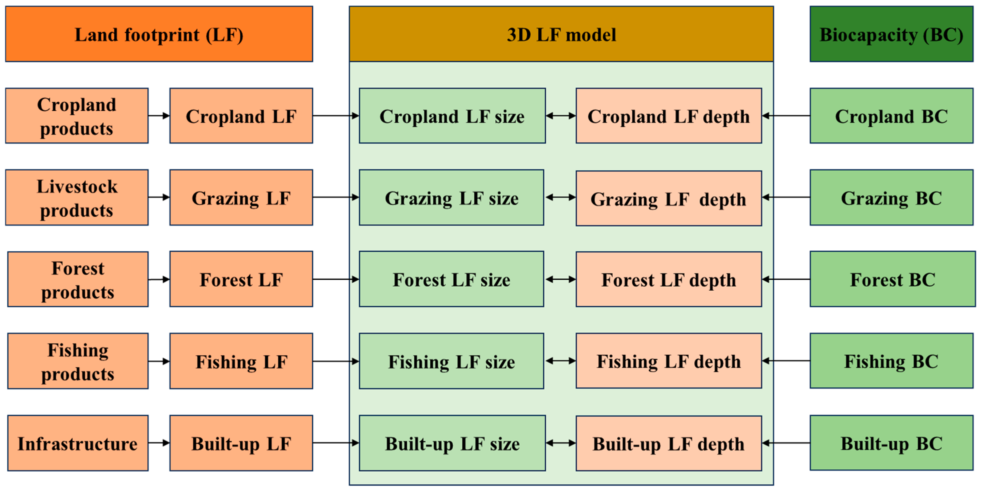
2.1. Land Footprint Analysis

By component, the EF consists of the carbon footprint (CF) and the land footprint (LF) [38]. In the classical EF model, the CF in a virtual form is argued to make up the majority of the quantities of the total EF [39]. By contrast, according to the assumption of the single functionality for land use, no dedicated biologically productive land is set aside for sequestering the carbon emissions [19]. In this respect, this study merely focuses on accounting for the LF in connection with biotic product provision [40]. The LF can be calculated as follows:
L F = i P i A P c , i × E Q F i
where Pi represents the amount of each product i harvested in a certain type of land use, APc,i represents the average country yield for product i in a certain type of land use, and EQFi represents the equivalence factor for a certain type of land use in terms of producing product i.
The BC refers to the area of biologically productive land available to provide ecological products and services, with a fraction of 12% that is reserved for maintaining biodiversity and the stability and resilience of the ecosystems [41], and is therefore calculated as follows:
B C = i 0.88 × A i × E Q F i × Y F p , i
where Ai represents the land area available for producing each product i, and YFp,i represents the province-specific yield factor for certain type of land use in terms of producing product i.

2.2. Land Footprint Size and Depth Analysis

The methodological framework accounting for the LF size and depth for different land use types is illustrated in Figure 1. By employing the 3D LF model, the sustainability of land use can be assessed. Of these, the LF size deals with the appropriation of annual flows of land as critical natural capital in the YRD, and can be calculated as follows:
L F s i z e = j m i n L F j , B C j
where LFj and BCj represent the LF and the BC for land use type j, respectively.
The LF depth communicates the intensity with regard to the depletion of the stocks of land, and is thus calculated as follows:
L F d e p t h = 1 + j m a x L F j B C j , 0 / j B C j

2.3. Spatial Autocorrelation Analysis

The Moran’s I referring to global autocorrelation and the Moran’s Ii referring to local autocorrelation are used to capture the spatial autocorrelation characteristics for the sustainability of land use among YRD cities using the following formulae [42]:
I = n i = 1 n j = 1 n W i j x i x ¯ x j x ¯ i = 1 n j = 1 n W i j i = 1 n x i x ¯ 2
I i = n x i x ¯ j = 1 n W i j x j x ¯ i = 1 n x i x ¯ 2
x ¯ = 1 n i = 1 n x i
where Wij represents the spatial weight between city i and city j, and xi and xj represent the LF size or depth of city i and city j, respectively. In this study, Queen contiguity of contiguity weight is chosen to construct the spatial weight matrix considering that the sustainability of land use of neighboring cities may interact with each other. Specifically, Wij = 1, if city i and city j are adjacent to each other; Wij = 0, otherwise. In addition, the spatial agglomeration can be classified into four categories: high-high (HH), low-low (LL), high-low (HL), and low-high (LH).

2.4. Spatial Econometric Analysis

The spatial econometric analysis can serve as a useful tool for exploring the spatial interaction effects within the socio-ecological systems among different locations [43]. Technically, the spatial econometric models can be selected to identify the socioeconomic drivers behind the sustainability of land use across the cities in the YRD. Among these models, the spatial lag model (SLM) includes a spatially lagged dependent variable indicating the spillover effect across spatial scale, the spatial error model (SEM) contains a spatially autocorrelated error term reflecting the interaction effect between spatial unit disturbances, and the spatial Durbin model (SDM) simultaneously explores both effects emphasized by SLM and SEM [44], following the formulae, respectively:
Y = ρ W Y + X β + ε
Y = X β + λ W u + ε
Y = ρ W Y + X β + W X θ + ε
where Y represents an n × 1 vector that consists of an observation on the dependent variable for each unit; ρ stands for the spatial autoregressive coefficient; W denotes an n × n matrix that describes the spatial arrangement for the spatial units; X represents an n × k matrix that consists of the exogenous explanatory variables; β and θ denote a k × 1 vector that consists of the associated parameters; ε represents an n × 1 vector that consists of independently and identically distributed disturbance terms; λ stands for the spatial autocorrelation coefficient; and u represents an n × 1 vector that consists of the spatially autocorrelated error terms.

2.5. Data Sources

In this paper, 41 cities within the YRD are selected as the study area (Figure 2). The data used in the study are annual. In accounting for the LF and BC, the data on the primary products harvested in various land use types of cities are derived from the provincial and city-level statistical yearbooks. The equivalence factors and the yield factors for different land use types are provided by Liu et al. [45] and Liu et al. [46], respectively. The area of different land categories for those cities are obtained from the sharing application service platform of national land survey results. The data on most related socioeconomic indicators (Table 1), including per capita disposable income, per capita GDP, proportion of primary industry added value to GDP, proportion of secondary industry added value to GDP, proportion of total export value to GDP, proportion of total import value to GDP and urbanization rate are derived from provincial statistical yearbooks. In addition, the population density and proportion of built-up area are obtained from China urban construction statistical yearbooks.

3. Results

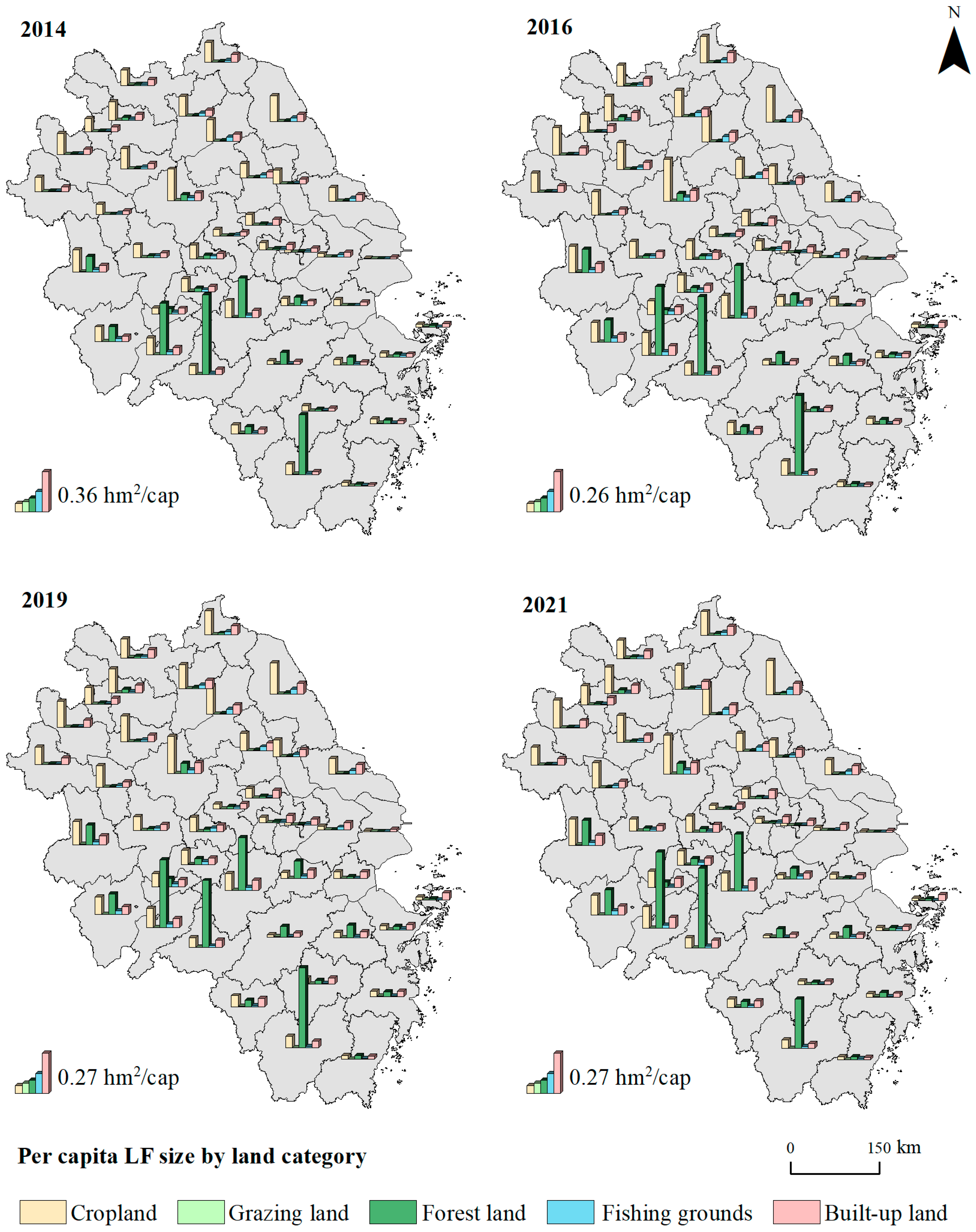
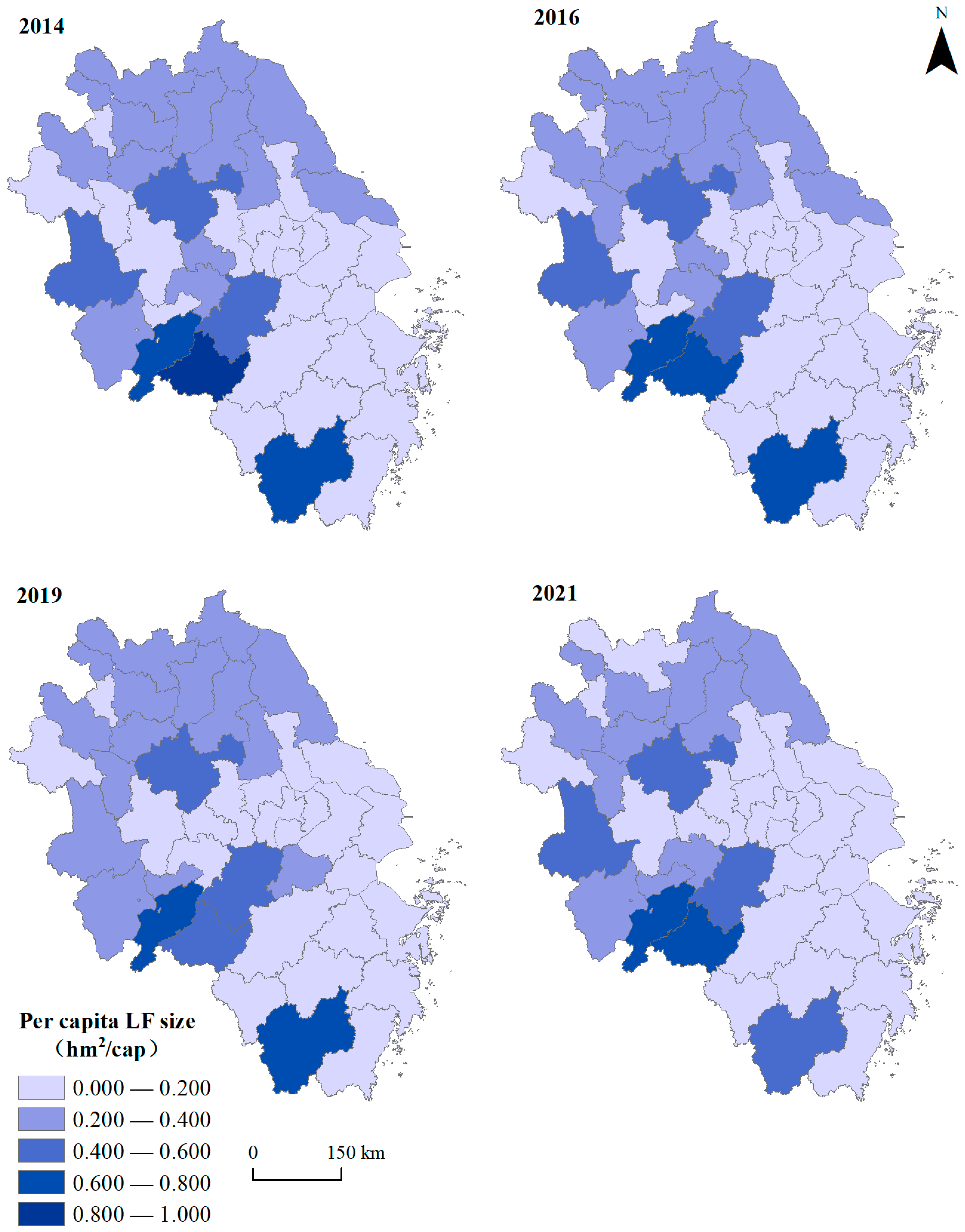
3.1. Sustainability of Land Use in YRD Cities

3.1.1. Cropland

The cropland use in the YRD has been operating in an environmentally unsustainable state over the years. The appropriation of cropland flows and the depletion of cropland stocks can be simultaneously observed in most cities. As presented in Figure 3 and Figure 4, the LF size and depth of cropland remain relatively stable and spatially heterogeneous during the study period. Overall, rich appropriation of flows of cropland is mainly located in the northwest, while intensive depletion of stocks of cropland is located in cities scattered in various regions. Of these, Chuzhou is found to have the largest per capita LF size (0.253–0.281 hm2/cap) and relatively low LF depth (1.533–1.635), showing a small gap between demand and supply of cropland. Similarly, Suzhou has the lowest LF depth (1–1.434) and mediate per capita LF size (0.021–0.030 hm2/cap). By contrast, Shanghai has the smallest per capita LF size (0.008–0.010 hm2/cap) and relatively high LF depth (2.284–3.170), indicating a large gap between human demand and cropland supply. This is also true for Quzhou where the highest LF depth (2.271–3.213) and mediate per capita LF size (0.056–0.079 hm2/cap) can be seen.

3.1.2. Grazing Land

The grazing land use of most YRD cities has been operating in a deficit for a period of time. That is, the appropriation of grazing land flows for most cities is insufficient to support human demand for livestock products without depleting grazing land stocks. During these years, the flows and stocks of YRD’s grazing land maintain a relatively stable state of use, but the discrepancy between some cities is striking. Overall, poor appropriation of flows and intensive depletion of stocks for grazing land are commonly observed throughout the YRD. Of these, Fuyang is found to have the highest LF depth (1603.500–21,315.254) and the smallest per capita LF size (0.000008–0.0001 hm2/cap), reflecting a considerably huge gap between human demand and grazing land supply. On the contrary, Zhoushan has the largest per capita LF size (0.0012–0.0064 hm2/cap) and the smallest LF depth that is always equal to 1, giving rise to a desirable state of appropriation of grazing land flows without undermining the maintenance of grazing land stocks.

3.1.3. Forest Land

The forest land use of most YRD cities has been running in a state of environmental sustainability, resulting from the continuous maintenance of forest land stocks (Figure 3 and Figure 4). The appropriation of annual flows of forest land remains stable for most cities during these years, with the discrepancy between some cities. Overall, abundant appropriation of forest land flows is located in the southwest, whereas intensive depletion of forest land stocks is scattered in a small fraction of cities. Of these, the largest and smallest per capita LF size are observed in Huangshan and Shanghai, respectively. Comparatively, Suqian has the highest LF depth (6.193–40.561), indicating a large gap between human demand and forest supply.

3.1.4. Fishing Grounds

The fishing ground use of most YRD cities has been environmentally unsustainable during the period. Although flow appropriation and stock depletion of fishing grounds for most cities remain stable, the discrepancy between cities can still be identified. Overall, poor appropriation of fishing ground flows is widely witnessed throughout the YRD, while intensive depletion of fishing ground stocks is mainly located in the northwest. Of these, the largest and smallest per capita LF size can be, respectively, observed in Yancheng and Zhoushan, whose LF depth is always equal to 1, implying self-sufficiency of these cities in providing fishing ground products. By contrast, Huainan has the highest LF depth (8.810–10.759), underlining a large gap between human need and ecological provision of fishing grounds.

3.1.5. Built-Up Land

The flows and stocks of built-up land in the YRD maintain a stable state of use, with a small discrepancy between some cities. Generally, rich appropriation of built-up land flows is mainly located in the northwest, while built-up land stocks remain undiminished in Jiangsu and have experienced low depletion in other regions for the period of time. Of these, Chuzhou has the largest per capita LF size (0.071–0.077 hm2/cap) and low LF depth (1.114). By contrast, Shanghai has the smallest per capita LF size (0.013–0.016 hm2/cap) and the highest LF depth (1.403–1.758).

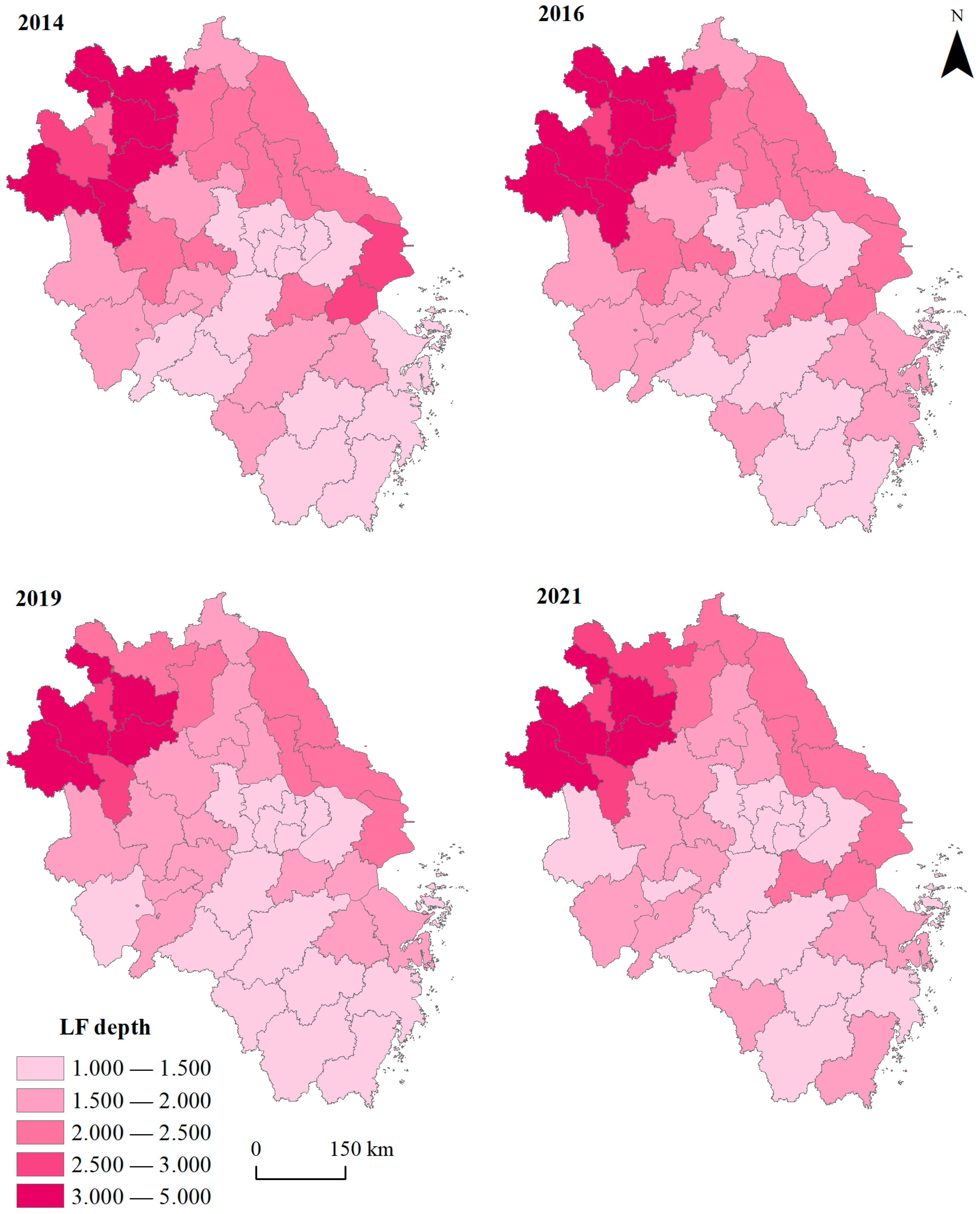
3.1.6. Aggregation of Land

By bringing together various land use types into one picture, cropland can be considered as the major source of land flows throughout the YRD. As shown in Figure 5, the aggregate appropriation of annual flows of land use of cities in the YRD remains relatively steady and spatially uneven as distributed during the period of time. Overall, the cities with high per capita LF size are mainly located in the west, followed by the north. This is probably due to the fact that land resources for each person in these regions are more abundant than other regions of the YRD. Simultaneously, Shanghai, cities in the south of Jiangsu and most cities of Zhejiang are densely populated with relatively scarce land resources, thus showing low appropriation of land flows.
The YRD as a whole is found to be operating in a state of ecological deficit in terms of land use during the study period. Figure 6 displays the spatio-temporal patterns of the depletion of land stocks. Overall, one may find that the LF depth of YRD cities remains relatively steady throughout the period. Geographically, intensive depletion of land stocks is mainly located in the northwest, followed by the northeast. Of these, the highest LF depth is observed in Bengbu, whose per capita LF size is small, showing a prominent gap between human need and natural provision of land resources. The cities with low LF depth are mainly in the southeast and southwest YRD. Of these, Zhoushan has the lowest LF depth, reflecting self-sufficiency in land use within the city to a large extent.

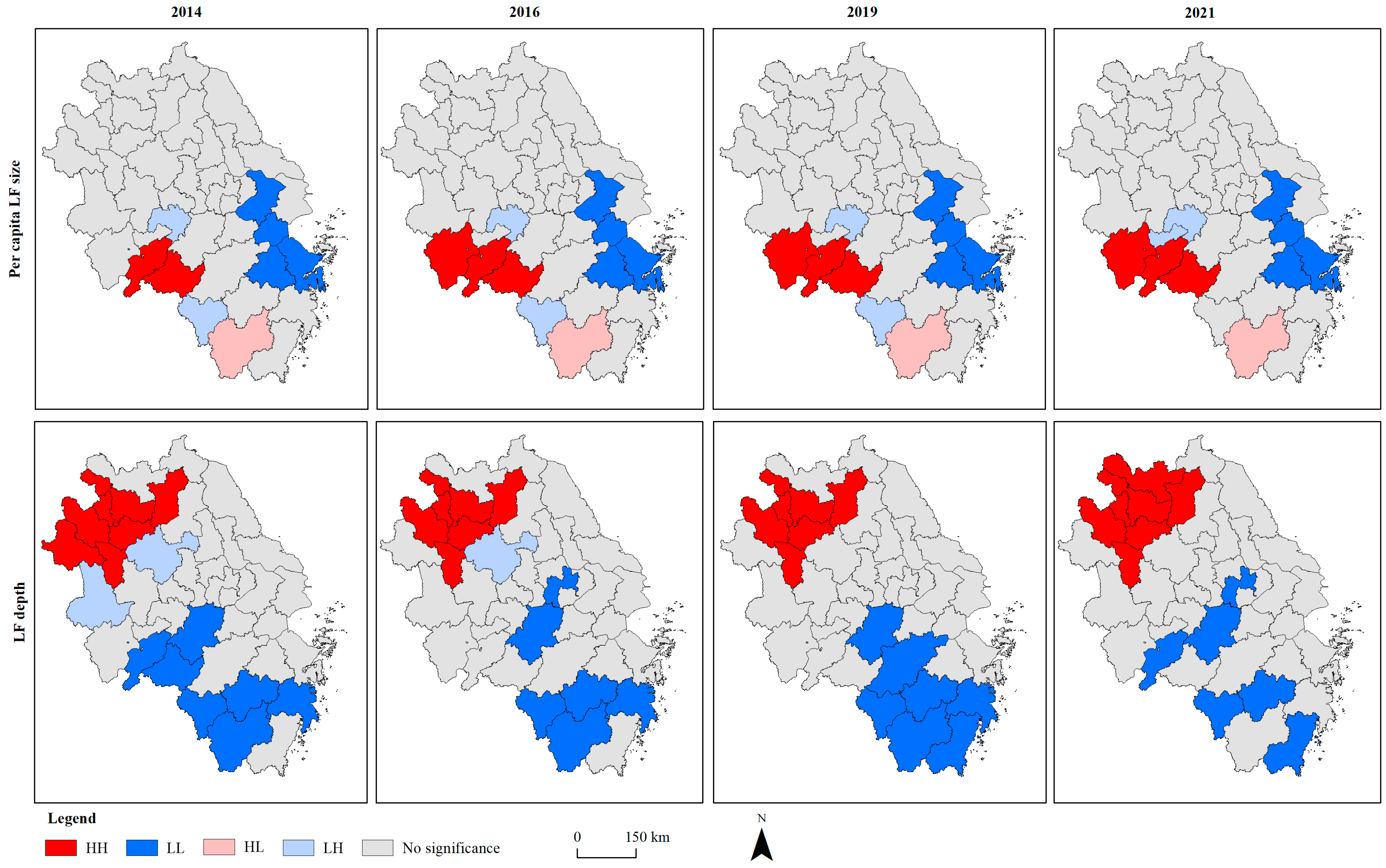
3.2. Spatial Autocorrelation of Sustainability of Land Use in YRD Cities

Generally, both flow appropriation and stock depletion of land use maintain a positively significant global autocorrelation across the cities in the YRD during the study period (Table 2 and Table 3). In addition, a significant local autocorrelation can also be observed for both per capita LF size and LF depth among YRD cities (Figure 7). As for the per capita LF size, HH, HL and LH agglomeration is found in the southwest, while LL agglomeration is found in the southeast. In terms of the LF depth, some northwestern cities are found to be of HH agglomeration, as opposed to some southwestern cities of LL agglomeration. Furthermore, few cities have LH agglomeration, while no HL agglomeration is observed across the cities. This may be caused by the spatial agglomeration in terms of ecological resources and land-related socioeconomic activities. That is, the stocks of land in the southwest are less depleted while socioeconomic activities in the northwest are more intensive.

3.3. Socioeconomic Drivers Underlying Sustainability of Land Use in the YRD

By comparing p values of Lagrange Multiplier (LM) test for the lag and error, it is found that only the LM-lag is significant. Hence, the SLM can be used to capture the socioeconomic drivers of sustainability of land use across the cities in the YRD. As demonstrated in Table 4, by comparing the values of R2 and Log-likelihood of SLM and Ordinary Least Squares (OLS) estimations, SLM is selected to explain the spatial interaction effects of socioeconomic factors on driving the sustainability of land use throughout YRD cities. Accordingly, the proportion of primary industry added value to GDP and per capita disposable income are found to have significantly positive effects on the depletion of land stocks. This is largely consistent with the above-mentioned finding that cropland is the major source of land flows in the YRD, which underscores the relationships between agricultural activities and sustainability of land use. That is, land sustainability has already been threatened by agricultural activities to some extent in the YRD. Additionally, as an indication of consumptive capability of land products, per capita disposable income may drive the unsustainability of land use. This is largely due to the fact that social consumption of land products has not totally decoupled from depleting land stocks.

4. Discussion

4.1. Scientific Contribution Analysis

In comparison with previous literature, we find that the scientific contribution of this study mainly lies in the methodological framework for assessing the sustainability of land use at aggregate and disaggregate levels and in exploring socioeconomic drivers across the whole scale [47]. That is, the structural characteristics of annual appropriation of land flows and depletion intensity of land stocks are tracked by using an improved 3D LF model where an ecological deficit in one land type is not allowed to be compensated by ecological surplus in others. In this respect, the spatio-temporal changes of sustainability of land use can be identified at multiple scales ranging from individual land types, cities and the whole YRD from a strong sustainability perspective. Additionally, the socioeconomic drivers underlying land use throughout the YRD cities are explored by taking into account spatial interaction effects, thus providing new insights for understanding the relationships between human activities and environmental sustainability of land use. From a broader point of view, our research can be regarded as one of context-based downscaling and methodological extensions for the doughnut-shaped framework that delineates the environmentally safe and socially just operating space for human development [48,49].

4.2. Limitations and Uncertainties

Although the LF size and depth can be quantified by employing the improved 3D LF model, the LF embodied in the trading commodities may be neglected, making the shifted burden of land use uncovered. To clarify the environmental responsibilities, incorporating the environmentally-extended multi-regional input and output analysis into the accounting framework of LF would be an effective way to figure out the impact of regional trade on the sustainability of land use [50,51]. To make sustainability assessment more reliable, data quality in terms of accuracy, completeness and consistency should further be improved. In addition, while the socioeconomic drivers behind land use sustainability are quantitively explored by means of spatial econometric models, the inter-linkages between those drivers and human socioeconomic needs remain largely unknown. To overcome this limitation, efforts should be made to address the issue as to how to achieve the land-related SDGs without undermining environmental sustainability of land use. In particular, tracking the synergies and/or trade-offs between economic, social and environmental dimensions of sustainability may be the key to approaching harmonious states of human-land systems.

4.3. Policy Implications

The findings of our research suggest that tackling the sustainability gap resulting from intensive land use presents a major challenge for YRD cities, thus underpinning the necessity for designing sustainability policies that take socioeconomic development and environmental sustainability into consideration simultaneously. In this sense, decoupling economic growth from annual appropriation of land flows and depletion of land stocks is of critical significance for the achievement of sustainable development in this region. According to spatial heterogeneity of sustainability of land use in the YRD, the cities in the northwest and the northeast should take effective measures to mitigate depletion intensity of land stocks while maintaining societal prosperity. Hence, there is a great need for eco-efficiency improvement in terms of production and consumption of land-related products. For the cities in the southeast and the southwest, with a relatively desirable state of sustainability of land use, pursuing high quality of socioeconomic development in respect of environmental boundaries can be an essential issue. In addition, the research findings could also be of significance for other regions facing similar challenges in addressing the trade-offs between socioeconomic development and land sustainability.

5. Conclusions

This paper assesses the sustainability of land use in YRD cities by using an improved 3D LF model, and tracks underlying drivers by using spatial econometric models. The results demonstrate that various land use types (i.e., cropland, grazing land, fishing grounds and built-up land) have been running in a state of environmental unsustainability for most YRD cities over a period of time, although the use of forest land remains sustainable in most cities. Generally, cropland is found to be a major source of land flows while experiencing relatively low depletion of land stocks. By contrast, grazing land is found to have poor appropriation of flows while suffering from severe depletion of stocks. Overall, annual appropriation of land flows remains relatively stable but geographically uneven, with rich per capita flows in the west and north YRD. Similarly, the depletion of land stocks remains largely unchanged but spatially heterogenous during the period, with high LF depth in the northwest and northeast YRD, and low LF depth in the southeast and southwest YRD. Additionally, the proportion of primary industry added value to GDP and per capita disposable income significantly drive environmental unsustainability of land use. The findings of our research could provide new insights into understanding the linkages between socioeconomic activities and sustainability of land use for YRD cities, which are crucial for guiding sustainable development in this region.

Author Contributions

Conceptualization, K.F.; methodology, X.C. and K.F.; formal analysis, X.C.; data curation, X.M.; writing—original draft preparation, X.C.; writing—review and editing, X.C. and K.F.; visualization, X.M.; supervision, K.F. All authors have read and agreed to the published version of the manuscript.

Funding

This work was financially supported by the National Natural Science Foundation of China (72074193), the Key R&D Program of Zhejiang Province (2022C03154), the Philosophy and Social Science Planning Project of Zhejiang Province (24SSHZ012YB), and the Philosophy and Social Science Planning Project of Hangzhou City (2023QNRC17).

Data Availability Statement

The data presented in this study are available on request from the corresponding author due to the privacy and continuity of the research.

Conflicts of Interest

The authors declare no conflict of interest.

References

  1. Crutzen, P.J. Geology of mankind. Nature 2002, 415, 23. [Google Scholar] [CrossRef] [PubMed]
  2. Liu, Z.; Fang, K.; Xu, A.; Zhang, Z.; Zhu, J.; Wang, H.; Zhang, Y.; Xu, Z.; Jiang, F.; Zhang, Q.; et al. CO2 sequestration technologies may undermine China’s Sustainable Development Goals through the climate-energy-air-health cascade. Environ. Sci. Technol. 2025, 59, 23–34. [Google Scholar] [CrossRef]
  3. Tao, S.; Wu, X.; Fang, K.; Lin, D. Identifying drivers of county-level industrial carbon intensity by a generic machine learning framework. J. Clean. Prod. 2024, 454, 142276. [Google Scholar] [CrossRef]
  4. Biermann, F.; Bai, X.; Bondre, N.; Broadgate, W.; Chen, C.A.; Dube, O.P.; Erisman, J.W.; Glaser, M.; van der Hel, S.; Lemos, M.C.; et al. Down to earth: Contextualizing the Anthropocene. Glob. Environ. Change 2016, 39, 341–350. [Google Scholar] [CrossRef]
  5. Galli, A.; Đurović, G.; Hanscom, L.; Knežević, J. Think globally, act locally: Implementing the sustainable development goals in Montenegro. Environ. Sci. Policy 2018, 84, 159–169. [Google Scholar] [CrossRef]
  6. Raworth, K. A doughnut for the Anthropocene: Humanity’s compass in the 21st century. Lancet Planet. Health 2017, 1, e48–e49. [Google Scholar] [CrossRef]
  7. Schmidt-Traub, G.; Kroll, C.; Teksoz, K.; Durand-Delacre, D.; Sachs, J.D. National baselines for the Sustainable Development Goals assessed in the SDG Index and Dashboards. Nat. Geosci. 2017, 10, 547–555. [Google Scholar] [CrossRef]
  8. Xu, Z.; Chau, S.N.; Chen, X.; Zhang, J.; Li, Y.; Dietz, T.; Wang, J.; Winkler, J.A.; Fan, F.; Huang, B.; et al. Assessing progress towards sustainable development over space and time. Nature 2020, 577, 74–78. [Google Scholar] [CrossRef]
  9. Yin, H.; Xiao, R.; Fei, X.; Zhang, Z.; Gao, Z.; Wan, Y.; Tan, W.; Jiang, X.; Gao, W.; Guo, Y. Analyzing “economy-society-environment” sustainability from the perspective of urban spatial structure: A case study of the Yangtze River delta urban agglomeration. Sustain. Cities Soc. 2023, 96, 104691. [Google Scholar] [CrossRef]
  10. Costanza, R.; Daly, L.; Fioramonti, L.; Giovannini, E.; Kubiszewski, I.; Mortensen, L.F.; Pickett, K.E.; Ragnarsdottir, K.V.; De Vogli, R.; Wilkinson, R. Modelling and measuring sustainable wellbeing in connection with the UN Sustainable Development Goals. Ecol. Econ. 2016, 130, 350–355. [Google Scholar] [CrossRef]
  11. Costanza, R.; Daly, H.E. Natural capital and sustainable development. Conserv. Biol. 1992, 6, 37–46. [Google Scholar] [CrossRef]
  12. De Groot, R.; Van der Perk, J.; Chiesura, A.; van Vliet, A. Importance and threat as determining factors for criticality of natural capital. Ecol. Econ. 2003, 44, 187–204. [Google Scholar] [CrossRef]
  13. Pelenc, J.; Ballet, J. Strong sustainability, critical natural capital and the capability approach. Ecol. Econ. 2015, 112, 36–44. [Google Scholar] [CrossRef]
  14. Goodland, R.; Daly, H. Environmental sustainability: Universal and non-negotiable. Ecol. Appl. 1996, 6, 1002–1017. [Google Scholar] [CrossRef]
  15. Randers, J.; Rockström, J.; Stoknes, P.E.; Goluke, U.; Collste, D.; Cornell, S.; Donges, J. Achieving the 17 sustainable development goals within 9 planetary boundaries. Glob. Sustain. 2019, 2, e24. [Google Scholar] [CrossRef]
  16. Wackernagel, M.; Rees, W.E. Perceptual and structural barriers to investing in natural capital: Economics from an ecological footprint perspective. Ecol. Econ. 1997, 20, 3–24. [Google Scholar] [CrossRef]
  17. Borucke, M.; Moore, D.; Cranston, G.; Gracey, K.; Iha, K.; Larson, J.; Lazarus, E.; Morales, J.C.; Wackernagel, M.; Galli, A. Accounting for demand and supply of the biosphere’s regenerative capacity: The National Footprint Accounts’ underlying methodology and framework. Ecol. Indic. 2013, 24, 518–533. [Google Scholar] [CrossRef]
  18. Monfreda, C.; Wackernagel, M.; Deumling, D. Establishing national natural capital accounts based on detailed ecological footprint and biological capacity assessments. Land Use Policy 2004, 21, 231–246. [Google Scholar] [CrossRef]
  19. Barrahmoune, A.; Lahboub, Y.; Ghmari, A.E. Ecological footprint accounting: A multi-scale approach based on net primary productivity. Environ. Impact Assess. Rev. 2019, 77, 136–144. [Google Scholar] [CrossRef]
  20. Ekins, P.; Simon, S. Estimating sustainability gaps: Methods and preliminary applications for the UK and the Netherlands. Ecol. Econ. 2001, 37, 5–22. [Google Scholar] [CrossRef]
  21. Hu, X.; Dong, C.; Zhang, Y. Dynamic evolution of the ecological footprint of arable land in the Yellow and Huaihai Main grain producing area based on structural equation modeling and analysis of driving factors. Ecol. Inform. 2024, 82, 102720. [Google Scholar] [CrossRef]
  22. Mancini, M.S.; Galli, A.; Niccolucci, V.; Lin, D.; Hanscom, L.; Wackernagel, M.; Bastianoni, S.; Marchettini, N. Stocks and flows of natural capital: Implications for ecological footprint. Ecol. Indic. 2017, 77, 123–128. [Google Scholar] [CrossRef]
  23. Niccolucci, V.; Bastianoni, S.; Tiezzi, E.B.P.; Wackernagel, M.; Marchettini, N. How deep is the footprint? A 3D representation. Ecol. Model. 2009, 220, 2819–2823. [Google Scholar] [CrossRef]
  24. Niccolucci, V.; Galli, A.; Reed, A.; Neri, E.; Wackernagel, M.; Bastianoni, S. Towards a 3D national ecological footprint geography. Ecol. Model. 2011, 222, 2939–2944. [Google Scholar] [CrossRef]
  25. Chen, X.; Liu, Q.; Fang, K.; He, J.; Chen, Y.; Wang, T.; Fang, C.; Shen, Y. Tracking national sustainability of critical natural capital and the socioeconomic drivers in the context of the Belt and Road Initiative. Ecol. Indic. 2020, 114, 106315. [Google Scholar] [CrossRef]
  26. Yang, Y.; Hu, D. Natural capital utilization based on a three-dimensional ecological footprint model: A case study in northern Shaanxi, China. Ecol. Indic. 2018, 87, 178–188. [Google Scholar] [CrossRef]
  27. Peng, J.; Du, Y.; Ma, J.; Liu, Z.; Liu, Y.; Wei, H. Sustainability evaluation of natural capital utilization based on 3D EF model: A case study in Beijing City, China. Ecol. Indic. 2015, 58, 254–266. [Google Scholar] [CrossRef]
  28. Long, X.; Yu, H.; Sun, M.; Wang, X.; Klemeš, J.J.; Xie, W.; Wang, C.; Li, W.; Wang, Y. Sustainability evaluation based on the three-dimensional ecological footprint and human development index: A case study on the four island regions in China. J. Environ. Manag. 2020, 265, 110509. [Google Scholar] [CrossRef]
  29. Wang, Y.; Huang, J.; Fang, S. Sustainability assessment of natural capital based on the 3D ecological footprint model: A case study of the Shennongjia national park pilot. Sustainability 2019, 11, 956. [Google Scholar] [CrossRef]
  30. Fang, K.; Zhang, Q.; Yu, H.; Wang, Y.; Dong, L.; Shi, L. Sustainability of the use of natural capital in a city: Measuring the size and depth of urban ecological and water footprints. Sci. Total Environ. 2018, 631, 476–484. [Google Scholar] [CrossRef]
  31. Guo, J.; Wei, Z.; Xie, X.; Ren, J.; Zhou, H. Dynamic change and driving force of natural capital in Qinghai Province based on the three-dimensional ecological footprint, China. Ecol. Indic. 2022, 145, 109673. [Google Scholar] [CrossRef]
  32. Jiang, R.; Fei, L.; Kang, S. Analysis and prediction of urban agglomeration ecological footprint based on improved three-dimensional ecological footprint and shared socioeconomic pathways. Ecol. Indic. 2025, 170, 113079. [Google Scholar] [CrossRef]
  33. Fang, G.; Wang, Q.; Tian, L. Green development of Yangtze River Delta in China under population-resources-environment-development-satisfaction perspective. Sci. Total Environ. 2020, 727, 138710. [Google Scholar] [CrossRef] [PubMed]
  34. Hou, Y.; Zhang, K.; Zhu, Y.; Liu, W. Spatial and temporal differentiation and influencing factors of environmental governance performance in the Yangtze River Delta, China. Sci. Total Environ. 2021, 801, 149699. [Google Scholar] [CrossRef]
  35. Zhang, D.; Wang, X.; Qu, L.; Li, S.; Lin, Y.; Yao, R.; Zhou, X.; Li, J. Land use/cover predictions incorporating ecological security for the Yangtze River Delta region, China. Ecol. Indic. 2020, 119, 106841. [Google Scholar] [CrossRef]
  36. Luo, D.; Liang, L.; Wang, Z.; Chen, L.; Zhang, F. Exploration of coupling effects in the Economy–Society–Environment system in urban areas: Case study of the Yangtze River Delta Urban Agglomeration. Ecol. Indic. 2021, 128, 107858. [Google Scholar]
  37. Ni, R.; Wang, F.; Yu, J. Spatiotemporal changes in sustainable development and its driving force in the Yangtze River Delta region, China. J. Clean. Prod. 2022, 379, 134751. [Google Scholar] [CrossRef]
  38. Čuček, L.; Klemeš, J.J.; Kravanja, Z. A review of footprint analysis tools for monitoring impacts on sustainability. J. Clean. Prod. 2012, 34, 9–20. [Google Scholar] [CrossRef]
  39. Mancini, M.S.; Galli, A.; Niccolucci, V.; Lin, D.; Bastianoni, S.; Wackernagel, M.; Marchettini, N. Ecological footprint: Refining the carbon footprint calculation. Ecol. Indic. 2016, 61, 390–403. [Google Scholar] [CrossRef]
  40. Fang, K.; Wu, C.; Dong, L. The use of land natural capital in the context of urbanization. J. Nat. Resour. 2018, 33, 1–13. [Google Scholar]
  41. Yang, H.; Yan, S.; An, N.; Yao, Q. Using ecological footprint analysis to evaluate sustainable development in Lushan County, China. Land 2024, 13, 1081. [Google Scholar] [CrossRef]
  42. Anselin, L. Local indicators of spatial association—LISA. Geogr. Anal. 1995, 27, 93–115. [Google Scholar] [CrossRef]
  43. Li, M.; Li, C.; Zhang, M. Exploring the spatial spillover effects of industrialization and urbanization factors on pollutants emissions in China’s Huang-Huai-Hai region. J. Clean. Prod. 2018, 195, 154–162. [Google Scholar] [CrossRef]
  44. Elhorst, J.P. Applied spatial econometrics: Raising the bar. Spat. Econ. Anal. 2010, 5, 9–28. [Google Scholar] [CrossRef]
  45. Liu, M.; Li, W. The calculation of China’s equivalence factor under ecological footprint model based on net primary production. J. Nat. Resour. 2009, 24, 1550–1559. [Google Scholar]
  46. Liu, M.; Li, W.; Xie, G. Estimation of China ecological footprint production coefficient based on net primary production. Chin. J. Ecol. 2010, 29, 592–597. [Google Scholar]
  47. Wang, Z.; Tao, F.; Leng, H.; Wang, Y.; Zhou, T. Multi-scale analysis on sustainability and driving factors based on three-dimensional ecological footprint: A case study of the Yangtze River Delta region, China. J. Clean. Prod. 2024, 436, 140596. [Google Scholar] [CrossRef]
  48. Dearing, J.A.; Wang, R.; Zhang, K.; Dyke, J.G.; Haberl, H.; Hossain, M.S.; Langdon, P.G.; Lenton, T.M.; Raworth, K.; Brown, S.; et al. Safe and just operating spaces for regional social-ecological systems. Glob. Environ. Change 2014, 28, 227–238. [Google Scholar] [CrossRef]
  49. O’Neill, D.W.; Fanning, A.L.; Lamb, W.F.; Steinberger, J.K. A good life for all within planetary boundaries. Nat. Sustain. 2018, 1, 88–95. [Google Scholar] [CrossRef]
  50. Huang, Y.; Fang, K.; Liu, G.; Guo, S. Has the carbon emission trading scheme induced investment leakage in China? Firm-level evidence from China’s stock market. Energy Econ. 2025, 141, 108091. [Google Scholar] [CrossRef]
  51. Tang, Y.; Zhang, Q.; Fang, K. Does international trade reduce global carbon inequality? Evidence from a producer-consumer shared responsibility. J. Environ. Manag. 2024, 355, 120307. [Google Scholar] [CrossRef]
Figure 1. The accounting framework of 3D LF model employed in this study [30].
Land 14 00580 g001
Figure 2. The location of cities in the Yangtze River Delta. Suzhou * and Taizhou * indicate Suzhou city in Anhui province and Taizhou city in Zhejiang province, respectively.
Land 14 00580 g002
Figure 3. Per capita LF size of YRD cities by land category in 2014, 2016, 2019 and 2021.
Land 14 00580 g003
Figure 4. The LF depth of YRD cities by land category in 2014, 2016, 2019 and 2021.
Land 14 00580 g004
Figure 5. Per capita LF size of YRD cities in 2014, 2016, 2019 and 2021.
Land 14 00580 g005
Figure 6. The LF depth of YRD cities in 2014, 2016, 2019 and 2021.
Land 14 00580 g006
Figure 7. The spatial agglomeration of per capita LF size and LF depth among YRD cities in 2014, 2016, 2019 and 2021.
Land 14 00580 g007
Table 1. Abbreviation of selected socioeconomic indicators.
IndicatorAbbreviationIndicatorAbbreviation
Per capita disposable incomePCDIProportion of secondary industry added value to GDPPSIV
Per capita GDPPCGDPProportion of total export value to GDPPEV
Population densityPDProportion of total import value to GDPPIV
Proportion of built-up areaPBAUrbanization rateUR
Proportion of primary industry added value to GDPPPIV
Table 2. The values of global Moran’s I for per capita LF size across YRD cities in 2014, 2016, 2019 and 2021.
2014201620192021
Moran’s I0.1670.1590.1340.265
p-value0.0330.0390.0730.004
Z-score2.0751.9411.6823.093
Table 3. The values of global Moran’s I for LF depth across YRD cities in 2014, 2016, 2019 and 2021.
2014201620192021
Moran’s I0.4930.5690.6090.539
p-value0.0010.0010.0010.001
Z-score5.4066.2256.5965.828
Table 4. Comparison between SLM and OLS estimation results.
VariableOLSSLM
CONSTANT−2.088−2.025
lnPD0.0080.001
lnPBA0.3760.372
lnUR0.029 *0.018
lnPCGDP−6.396 × 10⁻⁶−5.016 × 10⁻⁶
lnPCDI2.178 × 10−52.599 × 10⁻⁵ *
lnPPIV12.309 **8.723 **
lnPSIV1.5141.196
lnPIV−0.344−0.488
lnPEV−0.439−0.459
R20.5310.618
Log-likelihood−29.509−26.371
Notes: * and ** indicate 10% and 5% level of significance, respectively.
Disclaimer/Publisher’s Note: The statements, opinions and data contained in all publications are solely those of the individual author(s) and contributor(s) and not of MDPI and/or the editor(s). MDPI and/or the editor(s) disclaim responsibility for any injury to people or property resulting from any ideas, methods, instructions or products referred to in the content.

