1. Introduction
Environmental degradation has become a major global environmental issue due to the fast growth of the global economy and the corresponding increase in energy consumption [
1]. PM
2.5, as a crucial component of air pollutants, can enter the human respiratory system. It has the characteristics of small particle size, large relative surface area, and easy adsorption of toxic and harmful substances, thus making it the largest environmental risk factor [
2]. PM
2.5 pollution not only affects human health, as various studies have proven that long-term exposure to PM
2.5 pollution may lead to cardiovascular, respiratory, and cerebrovascular diseases, but also causes economic losses to society due to increased medical costs and mortality [
3,
4]. Air pollution is more serious in developing countries than in developed countries, and they are key players in the prevention and control of air pollution [
5]. The global distribution of average PM
2.5 concentration over the last two decades showed that PM
2.5 concentration was on the rise in most developing countries, which was most pronounced in China and India, the two largest developing countries [
6]. Meanwhile, China is undergoing rapid land-use transformation, and the resulting changes in ecosystem structure and function have a significant impact on the urban environment and ecology. As the underlying surface of the atmosphere, land-use types and scales can directly affect PM
2.5 concentration to varied degrees. On the one hand, the different land types as "source-sink" landscapes directly influence PM
2.5 concentration [
7,
8], while on the other hand, they can modify the regional hydrothermal conditions and induce changes in local climate, which will have an indirect effect on the migration and transformation of PM
2.5 [
9,
10]. In this context, it is particularly essential to adopt corresponding measures to control the production and emission of PM
2.5 from the perspective of land use, which is also an important topic in urban research and environmental science research.
The sources of PM
2.5 can be categorized into natural and man-made sources. The natural sources include wind-borne dust and soil, forest fires, and so on; man-made sources include primary particulate matter emissions and secondary emissions resulting from atmospheric chemical reactions between primary particulate matter. These primary particulates come from direct emissions such as coal-burning soot, motor vehicle exhaust, energy production, industrial processes, and agricultural fertilization [
11]. Based on this, researchers in multidisciplinary fields have studied the relationship between various land-use types and PM
2.5 concentration. Infrastructure construction, vehicle exhaust emissions, industrial production, and other activities on impervious surfaces are generally regarded as important sources of PM
2.5 pollution. High-density urban construction also reduces natural surfaces, which is not conducive to the deposition and removal of particles [
12]. Forests are a major component of the regional land-use pattern, as their vegetation adsorbs particles through the leaf pores or retains the particles on the plants’ surface, directly affecting PM
2.5 concentration [
13]. Agricultural activities on cropland such as tillage, fertilization, and irrigation may increase soil dust, leading to an increase in PM
2.5 concentration [
14], but may be reduced by rational agricultural activities and soil management [
15]. Water bodies can promote particulate matter deposition by increasing humidity to reduce PM
2.5 concentration [
16]. Furthermore, studies have been inconsistent on the effect of grassland on PM
2.5 concentration. For example, Nguyen et al. [
17] showed that there was no significant correlation between grassland and PM
2.5 concentration, while Cai et al. [
18] found that the contribution of grassland and non-grassland interactions to PM
2.5 was much higher than the individual contribution of grassland on a larger scale, suggesting that grassland can regulate PM
2.5 concentration. These studies provide a basis for understanding the relationship between land use and PM
2.5 concentration.
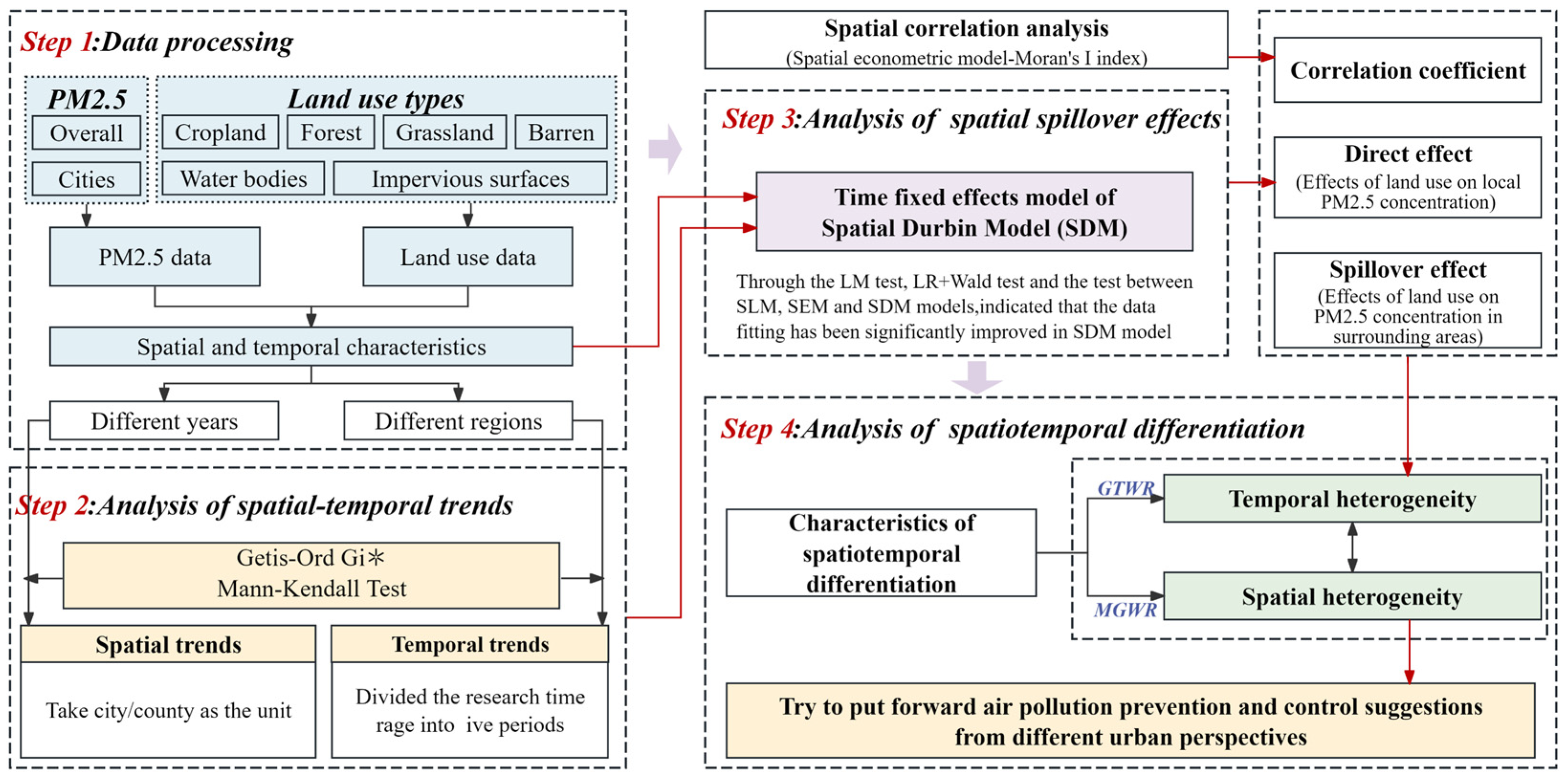
In previous studies, land-use regression (LUR), the spatial lag model (SLM), and the spatial error model (SEM) have been used to study the relationship between land use and PM
2.5 pollution [
19,
20,
21]. Meanwhile, ordinary least square (OLS) is a classical linear regression method applicable to the direct relationship between explanatory variables and independent variables [
22,
23]. However, for spatial data, OLS ignores its non-stationarity, which may lead to unreasonable conclusions. Therefore, some scholars have proposed the geographically weighted regression (GWR) model to solve this problem, which has been widely used in existing studies [
24,
25]. Nevertheless, the heterogeneity and non-stationarity between land use and air pollutants in different regions and at different times could not be considered in the above models. In contrast, the Geographically and Temporally Weighted Regression (GTWR) and Multiscale Geographically Weighted Regression (MGWR) models were optimized on the basis of GWR, which solved the problem of local and temporal changes in variables and could reveal the effects of global variables at regional scales and multiple time series [
26,
27]. Under the influence of long time series of land cover pattern changes, PM
2.5 pollution shows different responses, and there are some limitations in the spatiotemporal continuity of the existing studies. Currently, there is a lack of research on the spatiotemporal characteristics of the coupling between land use and PM
2.5 concentration. Therefore, combining the spatial econometric model with the GTWR and MGWR models can effectively analyze the response of the regional PM
2.5 concentration to land use, which can help to more accurately explain the spatiotemporal heterogeneity of the linkage between the two.
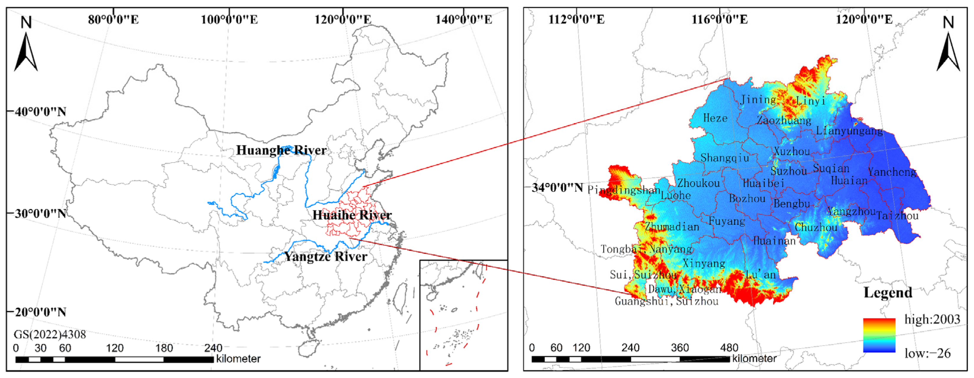
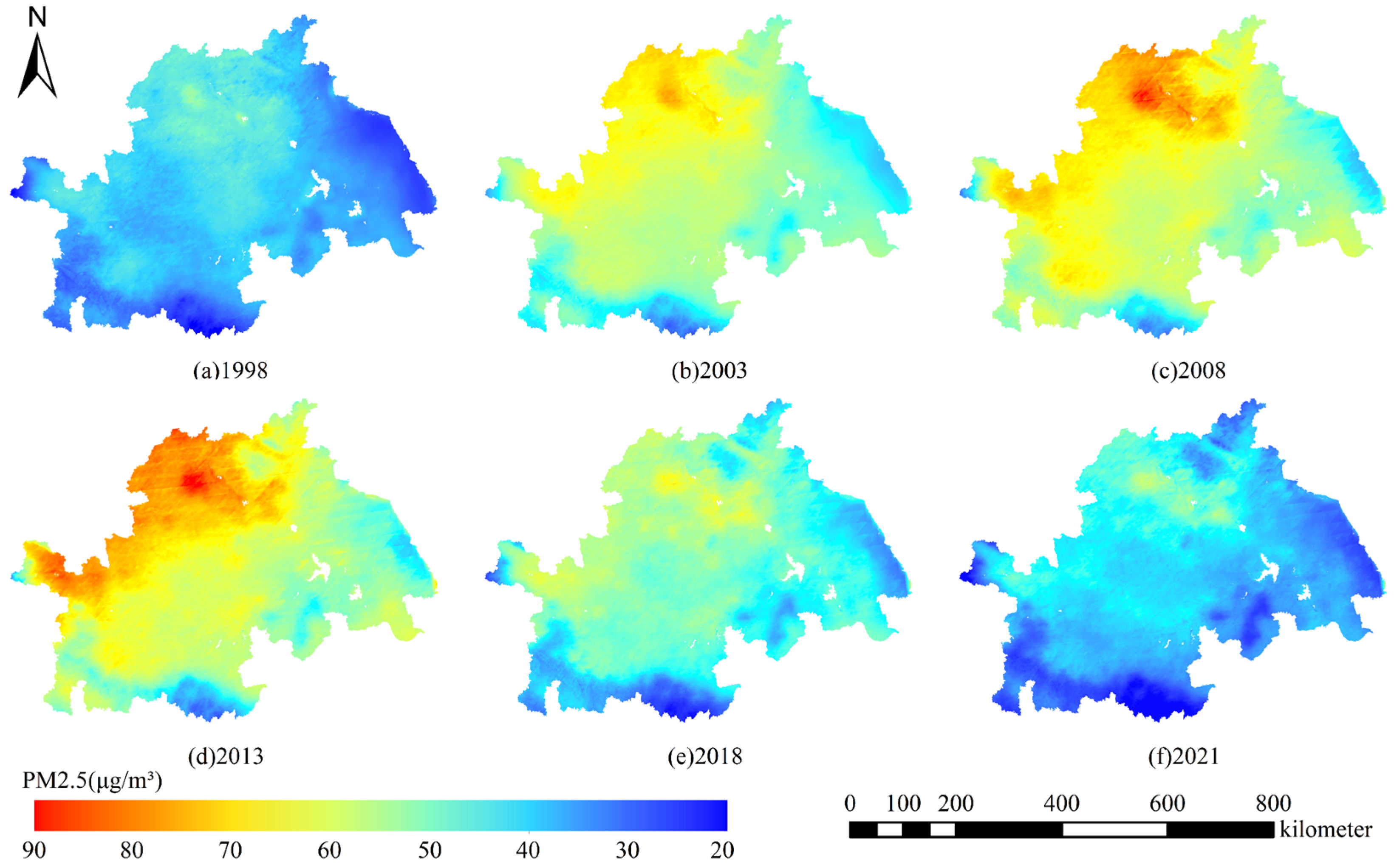
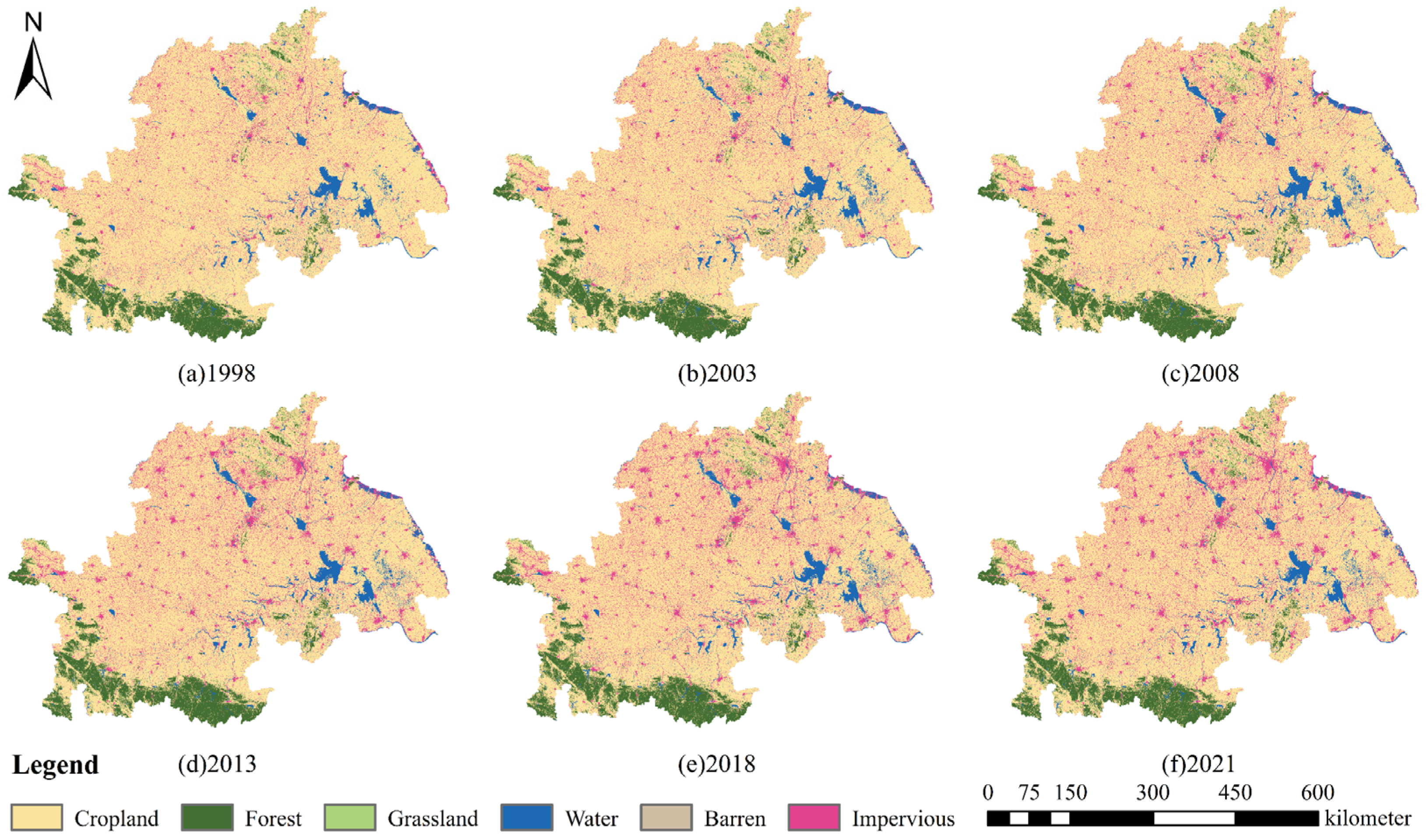
The Huaihe River Ecological Economic Belt consists of 5 provinces and 29 cities (counties), featuring distinct economic, political, and cultural differences. It serves as an essential ecological security barrier for China’s ecological civilization construction and high-quality economic development, as well as a significant area for territorial space development [
28,
29]. Compared with the Yangtze River Delta, the Shandong Peninsula, and the Central Plains urban clusters around the basin, the Huaihe River Ecological Economic Belt has lacked policy impetus in recent years and presented obvious problems such as unbalanced, inadequate, and uncoordinated regional development [
30]. This region has a high population density and rapid urbanization process. For a long time, under the economic priority development mode, industrial and agricultural non-point sources of pollution in the Huaihe River Basin have been prominent, with large changes in land cover, especially the replacement of vegetation cover by artificial buildings, resulting in a decrease in the surface’s ability to absorb and block dust and a serious situation of urban air pollution [
31]. Given this, from the perspective of ecological coordination, this study selected the Huaihe River Ecological Economic Belt, which is a national key development area with an emphasis on ecological environment governance, as the research area. It utilized high-precision land-use data and PM
2.5 concentration data from 1998 to 2021, based on the long time-series remote sensing inversion of PM
2.5 concentration data, and the relationship between PM
2.5 concentration and land use was revealed by using the spatial econometric model, the GTWR model, and the MGWR model. This paper addresses the following issues: (1) the effects of different land-use types on PM
2.5 concentration and its spatial spillover effect; (2) the spatiotemporal heterogeneity effects of land use on PM
2.5 pollution; (3) recommendations for the planning of rational urban layout and sustainable development. The findings of this study can reveal the role of land use in PM
2.5 prevention and control, which is of great significance for strengthening the joint environmental remediation among cities in the Huaihe River Ecological Economic Belt, trying to provide a basis for the formulation of air pollution prevention policies and urban land planning for urban clusters in the Huaihe River Ecological Economic Belt, so as to promote the construction of ecological civilization and social development.
4. Discussion
4.1. Effects of Land Use on PM2.5 Concentration
Different land-use types have different effects on PM
2.5 concentration. Specifically, the results of the spatial econometric model indicated that PM
2.5 concentration was significantly positively correlated to impervious surfaces on the whole scale of the Huaihe River Ecological Economic Belt. Zhang et al. [
44] identified five major sources of PM
2.5 through the positive matrix factorization (PMF) model, which are secondary aerosol and coal combustion, vehicles, industry, biomass combustion, and dust, while the rapid expansion of construction land will significantly increase the production of these substances. Hu et al. [
45] reached a similar conclusion. The rapid expansion of impervious surfaces is an important source of PM
2.5. Compared with other land types, impervious surfaces were more frequently disturbed by human activities. With the rapid development of urbanization, the rapid expansion of urban areas and intense industrial activities, coupled with huge energy consumption and pollutants such as vehicle exhaust from human activities, directly lead to an increase in PM
2.5 concentration [
46,
47]. Similarly, Zhao et al. [
12] concluded that industrial activity was most likely to contribute to higher PM
2.5 pollution due to the fact that most of the production activities generate pollutant emissions, while street and transportation, logistics, and warehouse land generate vehicle exhaust, leading to an increase in PM
2.5 pollution. The results of this study indicated that PM
2.5 concentration was negatively correlated with forests and water bodies. The surface stomata of leaves and stems of trees can adsorb fine particulate matter in the air and reduce wind speed, which promotes the deposition of suspended particles in the air, thus having an extremely important dust-blocking effect [
48]. Water bodies can reduce PM
2.5 concentration through a variety of mechanisms such as increasing humidity, regulating microclimate, and promoting particle sedimentation. However, the specific effects are also influenced by factors such as geographical characteristics, meteorological conditions, and other human activities [
49]. Lu et al. [
10] pointed out that the “source” effect of water bodies will become apparent with the increase in the area, which may be due to water bodies promoting the hygroscopic growth of PM
2.5. In this study, PM
2.5 concentration was negatively correlated with cropland. Cropland is also a means of production, which can effectively reduce the PM
2.5 concentration through a large number of crop vegetation leaves and stems’ surface porosity retention and adsorption of dust and particulate matter. However, some studies have shown that cropland also leads to increased PM
2.5 pollution [
50,
51]. Therefore, the effect of cropland on PM
2.5 concentration depends on the intensity and mode of agricultural activities.
This study has shown that PM
2.5 concentration was positively correlated with grassland. Many scholars have studied that grassland can absorb and reduce PM
2.5 concentration [
10,
52] and that vegetation on grassland can adsorb fine particles and stabilize soils, reduce bare ground, and improve microclimate conditions. However, Nguyen et al. [
17] pointed out that grassland could not effectively adsorb suspended particles and might even be positively correlated with PM
2.5 concentration under certain conditions, which is similar to the results of this study. According to the regression results, barren areas were not sensitive to the effect of PM
2.5 concentration in this study. The possible reason for this is that grassland and barren areas occupied a small proportion of the land area in the Huaihe River Ecological Economic Belt, being relatively dispersed and fragmented and susceptible to being affected by neighboring landscapes, especially areas with a high concentration of pollution. This finding is consistent with the conclusion proposed by Wang et al. [
53], who suggested that fragmented watersheds and wetlands weakened the role of “sink landscapes” regarding PM
2.5 and instead increased PM
2.5 concentration levels in the presence of other landscapes. Therefore, fragmented grassland and barren areas weakened their effect on reducing PM
2.5 concentration and may lead to an increase in PM
2.5 concentration under the influence of other landscapes and land. To determine their relationship with PM
2.5 concentration, more accurate PM
2.5 concentration data and higher resolution land cover data are needed for further research.
The impacts of impervious surfaces, forests, cropland, grassland, and water bodies on PM
2.5 pollution have significant spatial spillover effects, and the direct effects of each category on PM
2.5 pollution were greater than the indirect effects, except for grassland and cropland. Specifically, impervious surfaces can significantly exacerbate PM
2.5 pollution in the region and its neighboring areas, while forests and water bodies can reduce that, with forests having a higher direct reduction effect on PM
2.5 than that of water bodies. The influence of cropland on PM
2.5 pollution was complex, both as a pollution “source” and “sink” [
54], reducing PM
2.5 pollution within the region but aggravating it in the neighboring area. This is probably due to the existence of straw burning and agricultural land tilling dust, etc. The incineration of crop residues emits carbon dioxide, carbon monoxide, non-methane hydrocarbons, nitric oxide, nitrogen dioxide, and atmospheric particulate matter, etc. The SO
2 and NO
X produced can be oxidized into secondary inorganic/organic aerosols (SIAs/SOAs), which become an important source of PM
2.5 generation [
43]. Through the effect of wind speed, coupled with the fact that most of the idle cropland does not differ from the barren areas, will in turn exacerbate PM
2.5 pollution in the local and neighboring regions, which is similar to the results of the study by He et al. [
36]. Therefore, regional collaborative governance is of great significance for controlling PM
2.5 pollution.
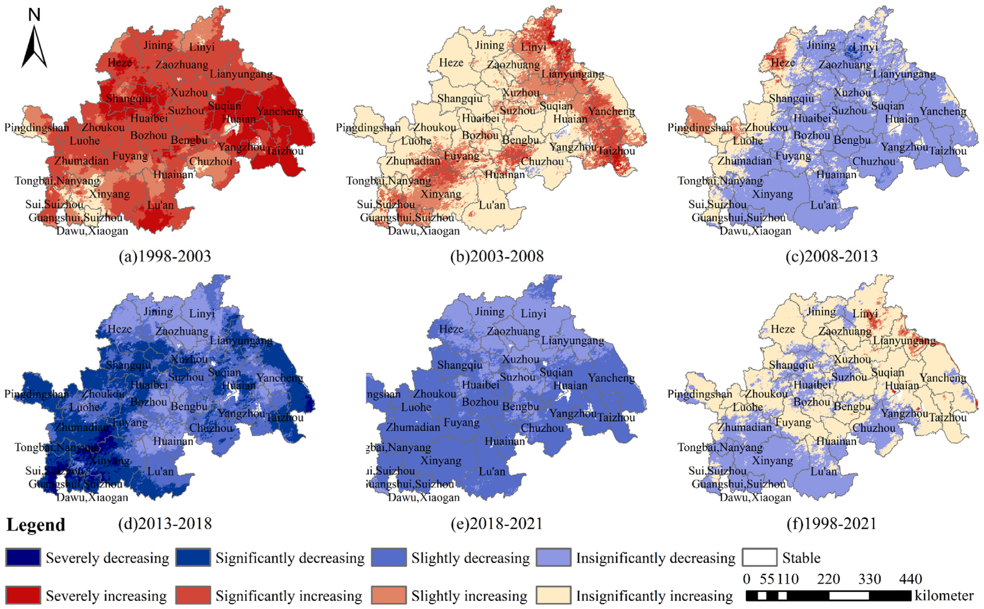
4.2. Characteristics of Spatial and Temporal Variability of Land Use on PM2.5 Concentration
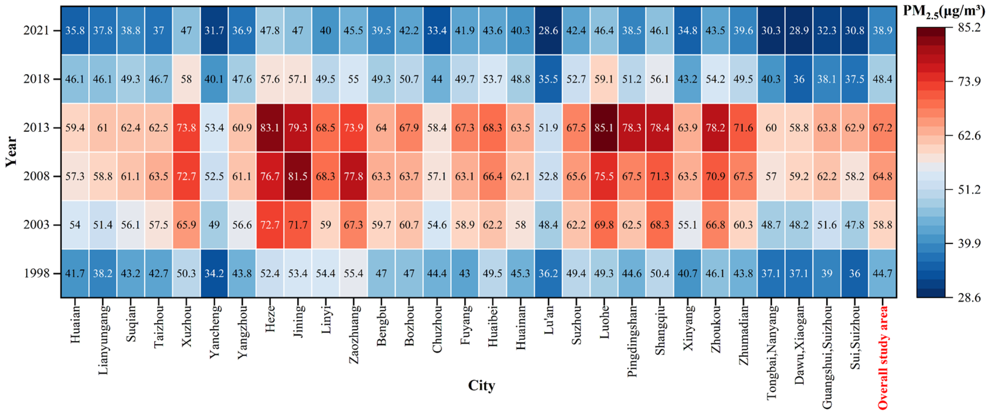
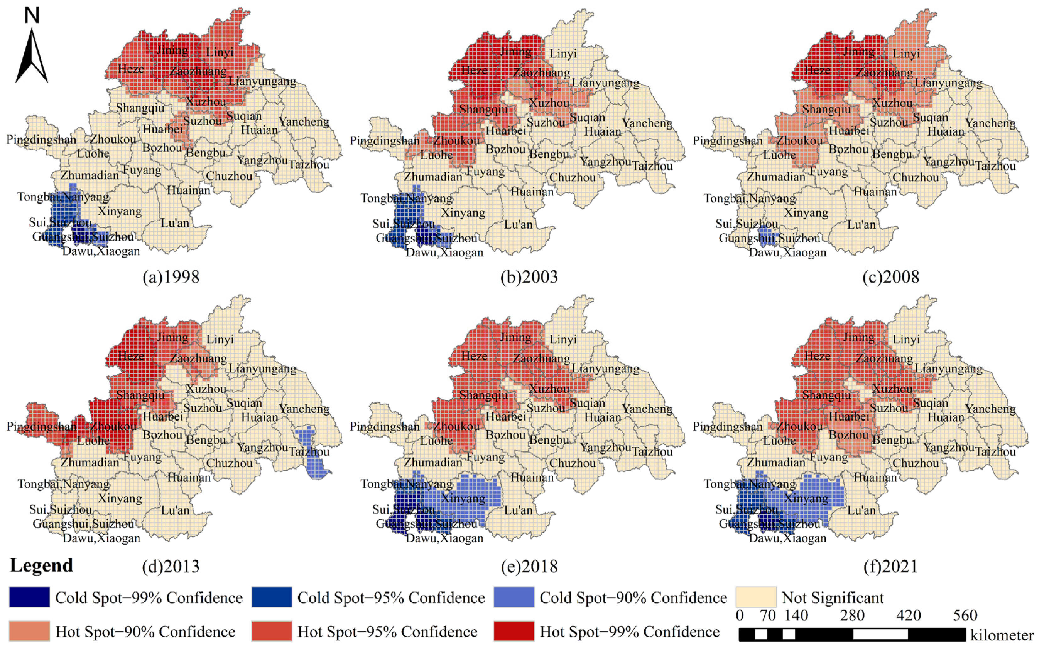
The situation of atmospheric pollution in the Huaihe River Ecological Economic Belt was complex. From the results of the GTWR model, during the study period, the influence of land use on PM
2.5 concentration in the cities (counties) of the Huaihe River Ecological Economic Belt showed obvious spatial and temporal differentiation characteristics. Before 2018, the weakening influence of cropland on PM
2.5 pollution gradually decreased, while the influence coefficient rose again after 2018. This indicates that the development plan of the Huaihe River Ecological Economic Belt put forward clear goals and specific measures in the areas of air pollution control and cropland use, which had a significant impact on the enhancement of the regional ecological environment. Wang et al. [
55] found that from 2016 to 2019, the ecological welfare performance index of the Huaihe River Ecological Economic Belt underwent a significant shift, with a substantial increase of 24.29%. This shift coincided with the society’s transition from rapid growth to high-quality development, indicating that local governments have begun to pay attention to environmental protection and the implementation of environmental regulations under the impetus of the urban ecological civilization construction and sustainable development evaluation framework, thus promoting the progress of ecological welfare performance in different cities. Meanwhile, the results of this study found that the impact of forests and water bodies on PM
2.5 pollution was slightly weakened, and the positive effect of impervious surfaces on PM
2.5 pollution significantly increased after the plan was proposed, suggesting that the rapid development of the Huaihe River Ecological Economic Belt after the plan was proposed led to the intensification of the ecological land patchiness and fragmentation, and the efficiency of climate regulation was affected. This in turn led to the reduction in biodiversity and the degradation of ecological service functions. Liu et al. [
56] pointed out that habitat fragmentation may lead to non-random loss of species that make high contributions to ecosystem function (reduced sampling effect) and reduced reciprocal interactions (reduced complementarity and facilitation effects).
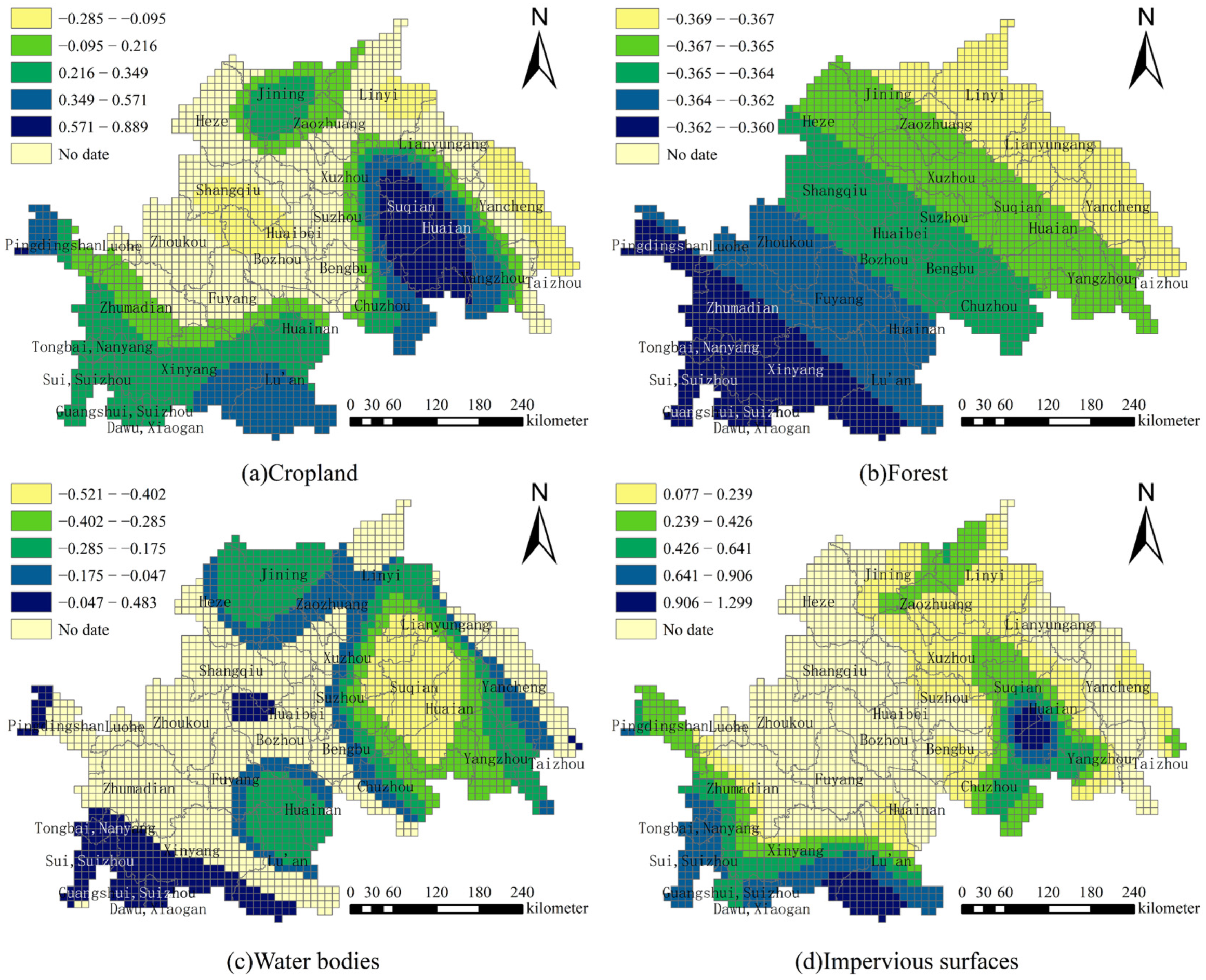
As expected, the MGWR coefficients varied across regions. The effects of cropland and water bodies on PM
2.5 concentration were negative in a large range, while the positive effects were found in a small range. Similar results were also obtained by Hong et al. [
57]. In addition, forests showed negative effects on PM
2.5 concentration, while impervious surfaces had positive effects on PM
2.5 concentration. Among them, the influence coefficients of forests were relatively average in the whole area, while cropland, water bodies, and impervious surfaces had large differences in different areas, dominated by the cities in the northeast, such as Jining, Zaozhuang, Yancheng, Yangzhou, and Xuzhou, and the southern cities, mainly including Nanyang, Huainan, Suizhou and Xiaogan. In the results of MGWR for the four land types, Linyi, Yancheng, Huaian, Xuzhou, and Xinyang cities had higher contributions to the reduction in PM
2.5 concentration, with most of them belonging to the central leading cities of the Huaihe River Ecological Economic Belt, indicating that the central leading cities had better strategies and regional prevention plans, together with a more reasonable overall land-use pattern. Generally speaking, different types of land use had different driving mechanisms for PM
2.5 concentration; over time, the intensity and scope of the impacts of different land-use types changed with the expansion of urban areas and the development strategies of different regions.
4.3. Proposals for Mitigating Air Pollution from the Land-Use Perspective
The Huaihe River Ecological Economic Belt is rich in biodiversity and has a vast plain area and a stable ecosystem, with a variety of natural resources such as beaches, rivers, forests, and grasses, which should be combined with the natural conditions to guide the zoning of different main functional areas. With the continuous expansion of cities, there are more ecological patches with a high degree of fragmentation and poor quality. Therefore, the intensification of land should be strengthened to optimize land-use structure and integrate patches, so as to reduce the impact of urban expansion on air pollution [
58]. This study confirms the spatial spillover effect of land use on PM
2.5 pollution, highlighting the need for regional collaborative governance. Regional cooperation mechanisms for land resource management and PM
2.5 pollution should be developed to share technologies and resources and to accelerate regional environmental monitoring, information sharing, and collaborative law enforcement to achieve joint prevention and treatment of PM
2.5 pollution [
59,
60]. In addition, the ecosystem services of different levels of cities in the Huaihe River Ecological Economic Belt have different degrees of response to urban expansion, and graded policies and classified development should be implemented according to the law of city development to improve the targeting and landing of spatial planning. Therefore, based on the ecological synergistic perspective, this study tried to put forward relevant optimization suggestions from the perspective of different city levels:
(1) In megacities and large cities such as Xuzhou, Huainan, and Huaibei, the contradiction between cropland and ecological land such as cropland and water bodies with PM2.5 pollution was relatively prominent. It is necessary to appropriately increase vegetation coverage, reduce excessive and inappropriate use of cropland, and promote the modernization and green transformation of agricultural production. At the same time, attention should be paid to optimization of the internal landscape structure to alleviate ecological degradation caused by urban expansion.
(2) The impact of urban expansion on air pollution in medium-sized cities was more significant than that in megacities and large cities, and most of the other ecological land use had a weaker function in regulating air pollution. Under the new pattern of development, the restoration of wetlands and the construction of a water body network along the Huaihe River should be increased, so as to build a systematic and holistic green space network in conjunction with the Jianghuai Ecological Corridor and Yishusi River Ecological Corridor. Through the diversification of vegetation structure and composition and the optimized spatial configuration of the corridor network, the regional ecosystem services will be further improved, and the connectivity between ecological sources will be strengthened.
(3) Medium-sized cities should give full play to their advantages in supplying services, optimize the layout and structure of production space, and strengthen the control of ecological space in urban fringe areas. During the past two decades, small cities have developed rapidly with a persistently high index of urban expansion intensity. Special attention should be paid to optimizing the spatial structure of urban built-up areas, reducing the destruction and encroachment of ecological space, improving the planning of the green space system, and making greater efforts in the areas of strengthening land-use regulations, evaluating the management of urban growth, preserving farmland, and improving the environment for agricultural production to form a compact urban pattern.
(4) In addition, combined with PM2.5 data from satellite remote sensing and ground monitoring, in the construction of the health pattern of public health governance, a grid-based pollution tracing system can be established to accurately identify pollution sources and draw health risk maps. It can also upgrade the early warning and response mechanism and promote the establishment of the regional ecological compensation mechanism through health risk assessment. At the same time, PM2.5 estimates can be used to assess the risk of PM2.5 pollution exposure in different regions by revealing its quantitative relationship with land use, identifying areas where highly polluting industries are clustered. Policy makers can evaluate the economic cost of pollution, design incentive or constraint mechanisms, and implement policy scenario simulation for better land-use control.
The Huaihe River Ecological Economic Belt is a demonstration belt for the construction of ecological civilization in the basin and a demonstration belt for new urbanization. The ecological construction of the Huaihe River Ecological Economic Belt can play a radiation-driven role and promote the overall development of the region. Promoting the scientific layout and optimization of its urban and ecological space has an important demonstration role in regional high-quality development.
4.4. Applicability in Other Regions
Similar studies in other urban agglomerations in China, such as the Zhengzhou metropolitan area and the city clusters along the middle reaches of the Yangtze River, have shown significant spatiotemporal heterogeneity in the impact of land use on PM
2.5. Although there are some commonalities in terms of pollution challenges and urbanization that are suitable for the models chosen for this study, the specific results obtained by the models in different regions vary under different scales, regional geography, meteorology, developmental status, and other conditions (
Table 7).
This study points out the impacts and spillover effects of land use on PM
2.5 concentration in the Huaihe River Ecological Economic Belt, which is also applicable in other developing countries (such as India, Iran, and Philippines). As these regions are generally characterized by dense traffic, industrial expansion, and ecological space compression, their rapid urbanization has severely exacerbated PM
2.5 pollution [
63]. Similarly, Hajiloo et al. studied air pollution in Tehran and found that improving urban vegetation and increasing green cover is a major strategy to mitigate PM pollution [
46]. This study found that cropland has a complex mechanism and may exacerbate PM
2.5 pollution due to straw burning and fertilizer use. The Gangetic Plain in India also faces this problem, as its cropland system produces large amounts of crop residue every year, much of which is burned in situ, thus exposing people in the area and nearby cities to extremely high levels of atmospheric pollutants [
64].
In addition, this study points out the significant spatiotemporal heterogeneity in the effect of land use on PM
2.5, which also applies to developed countries with similar pollution challenges. In developed countries, there is a certain phenomenon of “urban shrinkage”, such as population outflow, leading to hollowing of the land use, which may exacerbate the spatial heterogeneity of PM
2.5 concentration. A study of Seoul by Jeong et al. found significant differences in the effects of land structure on PM among administrative districts with different traffic volumes and development status [
65]. The relationship between land use and PM
2.5 is influenced by urban development factors such as economic conditions, policy context, and urban structure. While consistent with other similar regions, there are also differences. Various countries and regions need to prevent and control air pollution through sustainable urban development planning and rational land use by taking into account the local geographic environment, data conditions, and policy context.
4.5. Research Limitations and Further Prospects
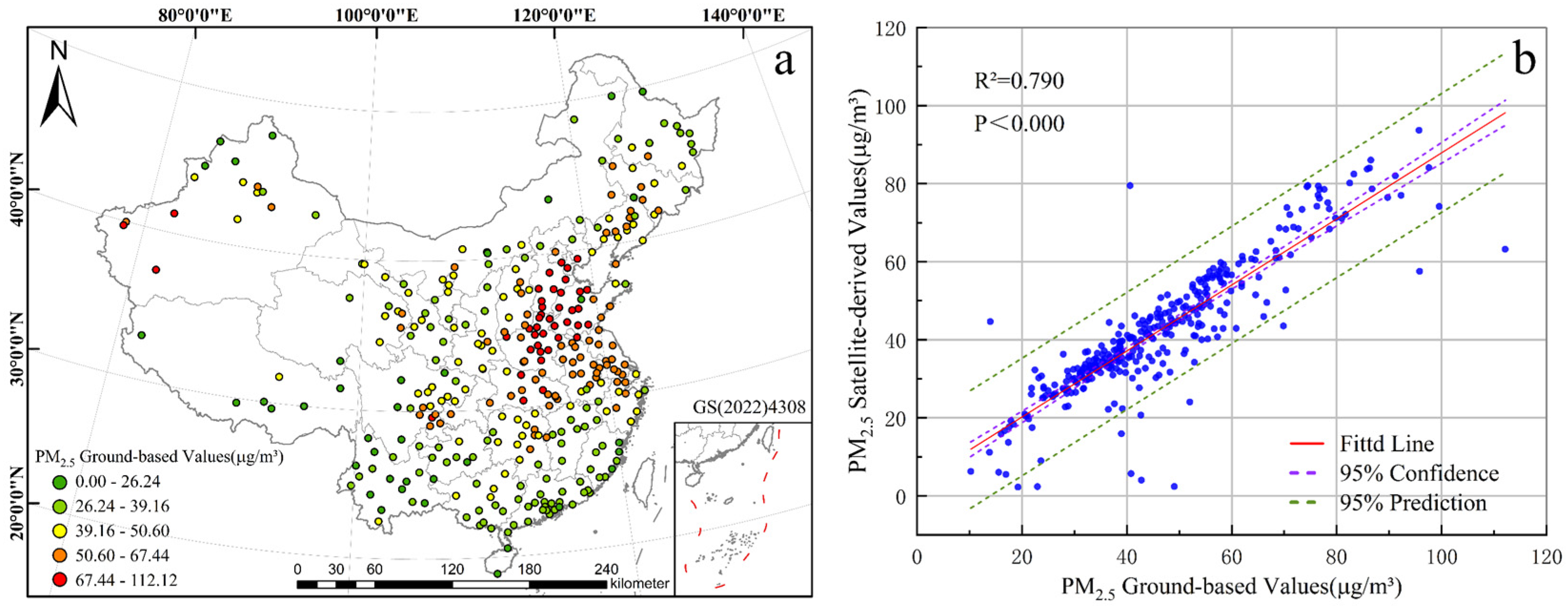
There are some shortcomings in the study. Firstly, due to the limitations of data, there is room to improve the data precision of the selected land cover data and PM
2.5 concentration data, without taking into account differences between months and seasons. At the same time, the proportion of some land-use types was too small, such that future study data with higher spatial resolution should be used to provide more accurate conclusions. Secondly, the relationship between PM
2.5 concentration and land use is also affected by landscape patterns, meteorology, scale, and other factors, which need further study. In addition, PM
10 and other air pollutant indicators were not included in this study due to data availability limitations. Although PM
2.5 is the current core indicator of air pollution effect, future studies will need to supplement data on other air pollutants to more comprehensively assess particulate matter risk and distinguish the difference in the source contribution of particles with different particle sizes. Meanwhile, this study used a combination of GTWR and MGWR models to explore the spatiotemporal heterogeneity among the study subjects, but with the development of spatial econometrics, some scholars have proposed Multiscale Geographically and Temporally Weighted Regression (MGTWR) [
66], which can consider spatiotemporal factors in the regression model to further improve the performance and efficiency of the model and at the same time solves the inconsistency of the model coefficients in the two-step analysis of GTWR and MGWR. Nevertheless, the computational method of the MGTWR has not been rigorously validated in other research fields, so it has not been adopted but could serve as a direction for subsequent research.


