Article

Spatial Structure and Corridor Construction of Railway Heritage: A Case Study of the Beijing-Tianjin-Hebei Region

1
School of Urban Construction, Yangtze University, No. 1 Xueyuan Road, Jingzhou 434000, China
2
Institute of Urban and Sustainable Development, City University of Macau, Avenida Padre Tomás Pereira, Taipa, Macau 999078, China
3
School of Architecture and Design, Beijing Jiaotong University, No. 3 Shangyuancun, Beijing 100044, China
*
Author to whom correspondence should be addressed.
Land 2025, 14(11), 2139; https://doi.org/10.3390/land14112139 (registering DOI)
Submission received: 22 September 2025 / Revised: 21 October 2025 / Accepted: 24 October 2025 / Published: 27 October 2025

Abstract

Railway heritage corridors, which integrate cultural history and natural landscapes, face limitations within the conventional “axis extension” construction model, where protection zones are radiated from existing railway lines. This approach hinders the development of cross-regional heritage networks and lacks scientific quantification in boundary delineation. This study proposes an innovative spatial planning paradigm for railway heritage corridors in the Beijing-Tianjin-Hebei (BTH) region, integrating railway heritage with the urban environment. Utilizing the minimum cumulative resistance model, a multidimensional resistance surface was created to identify potential corridor patterns based on centrality. Circuit theory quantified global connectivity, and statistical methods defined corridor widths. The case study identified 19 sources and 42 corridors across 54,399.42 km2, with an average length of 111.48 km and width of 9.24 km. These corridors form a closed network radiating from multiple centers, offering guidance for BTH tourism planning and heritage management.

1. Introduction

Since the 1960s, numerous conventional railways, defined by lower technical standards and earlier construction periods, have been supplanted by high-speed railways, leading to the progressive idling or abandonment of original lines, stations, and related infrastructure [1,2]. Presently, the total length of abandoned railways in China surpasses 20,000 km, contributing to localized traffic congestion and land value depreciation along these routes [3], which have had substantial adverse effects on socio-economic development. Nevertheless, railways with reduced transportation functionality retain significant value. Industrialization and urbanization have developed concurrently, with railways serving as critical infrastructure for urban expansion during the industrial era and exhibiting a historically interdependent relationship with urban environments, thereby endowing railway heritage with multifaceted regeneration opportunities [4,5].
Since the 1980s, international practices have developed mature paradigms for railway heritage adaptive reuse. In the United States, the Rails-to-Trails Conservancy (RTC) has systematically promoted the conversion of abandoned railways, thereby developing a 25,000-mile multi-use trail network that serves as a critical component of urban green infrastructure [6]. The European Greenways Association (EGWA), drawing upon the RTC’s experience, has constructed transnational recreational systems through the integration of disused railway corridors, thereby enhancing regional ecological connectivity and cultural heritage preservation [7]. In the United Kingdom, railway heritage conservation has evolved into a comprehensive management framework, with organizations such as the Heritage Railway Association (HRA) providing multifaceted support across all aspects of heritage railway ownership, management, and operation, encompassing fundraising, collaboration, trade facilitation, and technical assistance, thereby promoting heritage tourism and educational outreach [8]. These cases illustrate that the linear spatial characteristics and regional connectivity attributes of disused railways render them ideal conduits for integrating ecological, cultural, and recreational functions, thereby offering innovative directions for rational resource utilization and spatial development [9,10].

1.1. Trends in the Networked Transformation of Railway Heritage Protection

Heritage conservation concepts have evolved from preserving individual buildings to systemic, regionally oriented approaches [11]. Current research on railway heritage primarily assesses the regeneration potential across transportation, sociocultural, and ecological dimensions [12,13], fostering multiscale regeneration strategies [14,15]. At micro-node levels, stations undergo adaptive reuse as cultural facilities [16], while at meso-line levels, railway sections transform into non-motorized corridors [17] and green infrastructure [18].
Railway heritage’s primary value derives from distinctive linear spatial attributes and profound urban interdependence [19]. The built environment shapes railway alignment and construction complexity, whereas railways reciprocally link disparate cultural and natural landscapes [20,21], establishing heritage networks that integrate historical culture with urban environments and enable corridor-based development to unify regional resources and promote urban–rural synergy. However, existing research concentrates on localized renewals, lacking macro-regional frameworks. Although some studies have employed the “axis extension” model for heritage corridor development [22,23], this approach is constrained by predetermined spatial logic that rigidly adheres to existing railway infrastructure while overlooking the multidimensional relationships between heritage sites and their surrounding urban contexts. Consequently, such models produce inflexible corridors functioning primarily as protective buffers around railway lines, incapable of accommodating topographical diversity or incorporating dispersed heritage sites situated beyond the immediate railway proximity. More critically, this rigid adherence to linear configurations prevents the formation of interconnected heritage networks that could leverage synergies across multiple railway lines, industrial sites, and associated cultural landscapes. Therefore, railway heritage regeneration necessitates transitioning from “localized replacement” to “systematic integration”, establishing cross-regional composite heritage networks informed by corridor-based principles to ensure long-term sustainability.

1.2. The Need for Refined Development in Defining Corridor Widths

Within holistic conservation paradigms, heritage corridors have emerged as crucial tools for integrating linear heritage with urban spaces, emphasizing multiscale coordination from nodes to regions [24]. Defined as spatial networks connecting heritage sites with their surrounding contexts, heritage corridors prioritize integrating preservation with ecological conservation, cultural tourism, and education to maximize cultural and economic value. Current corridor development commonly employs the minimum cumulative resistance (MCR) model [25], where resistance represents the impedance that environmental factors impose on recreators’ movement between heritage sites. The MCR model generates a comprehensive resistance surface through factor magnitude assessment, models visitor movement patterns, and derives least-cost paths (LCPs) as optimal corridor routes via minimum cumulative cost distance computation. Nevertheless, existing studies on corridor development for linear heritage predominantly rely on expert judgment to assign resistance values and overlay weights [26,27], lacking unified standards, and are susceptible to data quality issues and subjective bias, thereby undermining result stability and reproducibility. This study employed the geographical detector’s factor detection module to quantitatively evaluate the environmental factors’ influence on heritage site spatial distribution, establishing indicator weights to enhance resistance surface accuracy and route planning validity.
While the MCR model effectively captures the influence of spatial resistance on corridor route planning, it lacks the capacity to determine corridor widths [28,29]. Heritage corridors exhibit significant boundary effects [30,31], with spatial scope directly affecting the efficacy in ecological conservation, cultural preservation, and transportation repurposing. One-dimensional linear features extracted from maps inadequately represent two-dimensional corridor surface attributes, offering limited practical guidance. Prevailing approaches establish corridor widths through empirical values or linear distance thresholds between heritage sites and corridor routes [32], defining it as a single, fixed spatial extent perpendicular to the centerline. However, this approach fails to recognize width as an adaptive parameter reflecting functional transitions from core heritage recreation zones to peripheral landscapes, neglecting the urban built environment heterogeneity’s influence on heritage recreation. The landscape functional connectivity model, grounded in circuit theory, provides innovative frameworks for delineating the heritage corridor spatial extent [33,34]. Circuit theory models species migration and dispersal processes through random electron movement principles [35,36], quantifying functional connectivity between ecological sources via current density [37,38]. Elevated current density signifies higher migration probability along specific pathways [39]. Heritage corridors, as linear cultural landscapes requiring a balanced integration of resource integrity, ecological connectivity, and regional coordination, demonstrate high compatibility with circuit theory applications. Accordingly, developing corridor width identification methodology, guided by functional connectivity, represents a critical step toward transitioning heritage corridor construction from linear to areal paradigms.

1.3. The Regeneration Value and Challenges of Railway Heritage Corridors in the BTH Region

Given the demand for the network-based conservation of railway heritage and the methodological challenges associated with corridor construction, conducting empirical research in representative regions can bridge theory and practice for multifunctional corridor realization. The Beijing-Tianjin-Hebei (BTH) region represents China’s most advanced modern railway development area. Since the late Qing Dynasty, a Beijing-centered railway system radiating nationally began to emerge. The railway heritage of the BTH region, epitomized by the Kaiping Colliery Tramway and Beijing–Zhangjiakou Railway, encapsulates a century of industrial evolution significantly shaping regional social development and urban transformation. Nevertheless, railway network reconfigurations and urban functional transformations have caused numerous line abandonments and demolitions. Lacking rational integrated management, railway heritage experiences escalating landscape fragmentation, thereby constraining its potential contributions to the economic, cultural, and ecological spheres.
Despite landscape fragmentation challenges facing the railway heritage in the BTH region, its profound historical significance and inherent linkage to regional transportation offer distinct heritage corridor establishment advantages. Regional modernization is intricately linked to railway system evolution, enabling efficient population and goods movement, reducing urban–rural and mining–port distances, catalyzing economic growth, and reinforcing Beijing’s political centrality, thereby establishing material foundations for regional integration. Given the role of railway heritage as a spatial linkage in coordinated regional development, selecting the BTH region as a study area to investigate pathways for constructing railway heritage corridors can theoretically validate the feasibility of network-based conservation for railway heritage while methodologically assessing the applicability of the circuit theory based width identification model.
Suboptimal railway heritage utilization adversely affects urban development, necessitating a cross-regional heritage network with defined protection boundaries to enhance regeneration efficacy. This study, grounded in heritage corridor theory, examined the BTH region as a case study of China’s densest railway heritage concentration to develop systematic conservation frameworks and methodologies. The objective was to establish a comprehensive research paradigm encompassing heritage source selection, resistance surface construction, corridor route planning, spatial extent delineation, and protection strategy development. Results provide robust scientific foundations for revising railway heritage policies and plans while serving as references for conserving other linear heritage forms. This study investigated the following critical questions:
(1)
Feature identification: What are the spatial distribution patterns of the railway heritage in the BTH region? Do discernible heritage clusters exist?
(2)
Mechanism analysis: How do environmental factors, including human and natural components, affect suitability zoning for railway heritage corridor development in the BTH region? Is spatial continuity present in areas deemed suitable for construction?
(3)
Methodological innovation: How can optimal routes and rational spatial extents of railway heritage corridors in the BTH region be scientifically established? Based on these findings, what differentiated regional collaborative conservation strategies can be proposed to address diverse protection and development objectives, thereby offering decision-making support for the effective conservation and rational utilization of railway heritage?

2. Materials and Methods

2.1. Research Area

The BTH region, located in the northern North China Plain, comprises the Beijing Municipality, Tianjin Municipality, and 11 Hebei prefecture-level cities, spanning 113°04′ E–119°53′ E and 36°01′ N–42°37′ N, covering approximately 218,000 km2 with a population of over 100 million. As northern China’s most economically advanced and densely populated area, its coordinated development constitutes a national strategic priority. This study focused on the railway heritage of the BTH region, developing a comprehensive list identifying structures, facilities, and equipment linked to six heritage railways: Beijing-Zhangjiakou, Beijing-Mukden, Beijing-Hankou, Beijing-Tongliao, Tianjin-Pukou, and Zhengding-Taiyuan. The temporal framework extends from the construction of the Kaiping Colliery Tramway in the 1880s to the completion of the Qinhuangdao-Shenyang high-speed railway in the early 21st century, encompassing China’s conventional railway inception to high-speed railway implementation. The research area follows BTH administrative boundaries. Given circuit theory’s emphasis on material foundation continuity and energy transmission fluidity in ecological processes [40], this study extended administrative boundaries as per existing research [41] by establishing a 50 km buffer zone along the outer perimeter to ensure effective circuit theory application to heritage corridors (Figure 1).

2.2. Data Sources

This study obtained essential data through field investigations, web crawling, and a comprehensive literature review. A spatial database was constructed using ArcGIS 10.7 to facilitate data integration, computation, and visualization. The specific data sources and preprocessing methods are listed in Table 1.

2.3. Research Methods

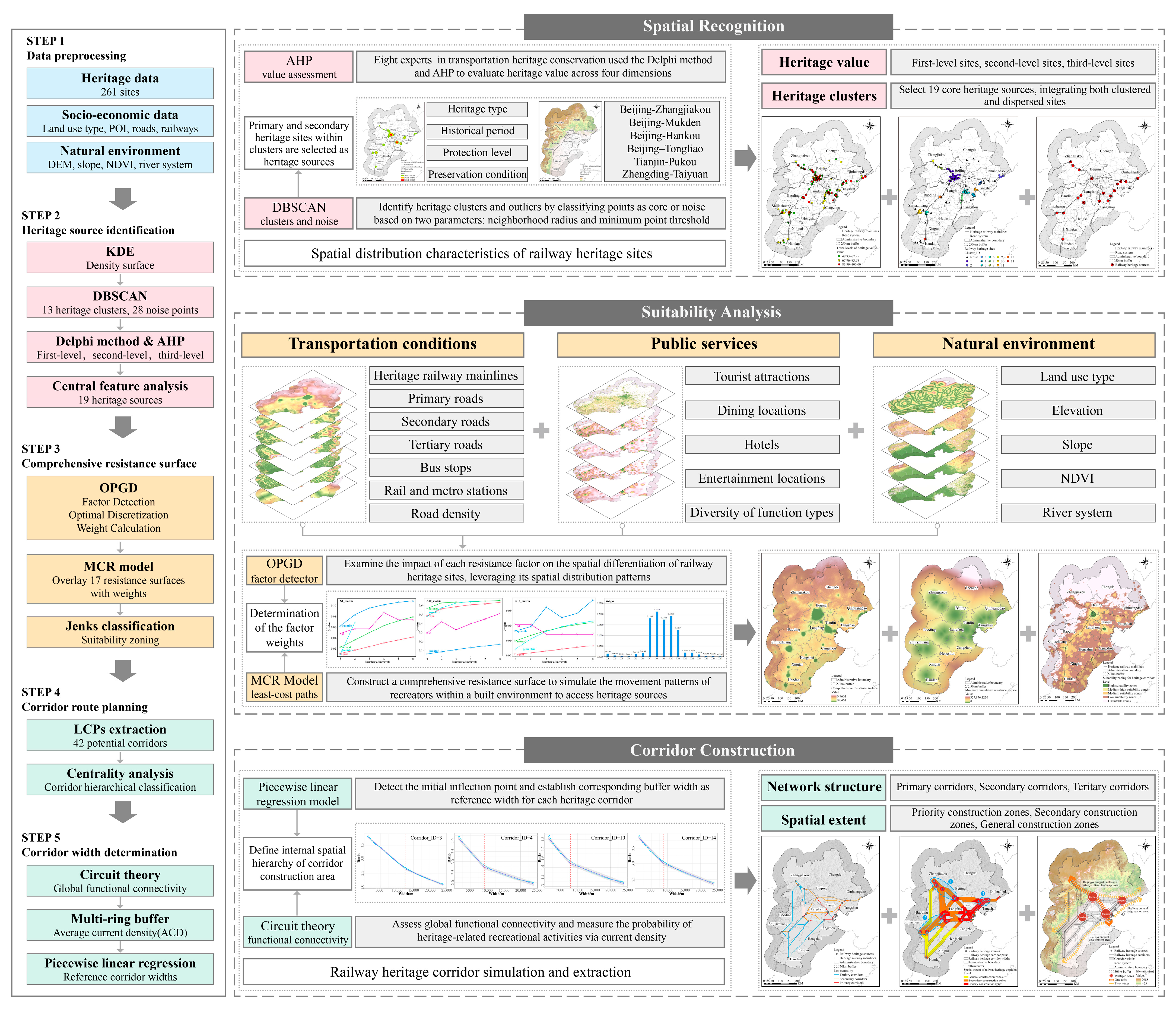
This study’s railway heritage corridor framework integrated three complementary methods: the OPGD, the MCR model, and circuit theory (Figure 2), facilitating systematic analysis from heritage source identification to spatial delineation. The research workflow included three sequential stages. First, cluster analysis identifies spatial agglomeration characteristics of BTH railway heritage sites, with cluster relative centers serving as heritage sources. Second, the MCR model integrates multifaceted resistance systems encompassing transportation conditions, public services, and the natural environment. OPGD quantifies each resistance factor’s influence on railway heritage spatial differentiation, providing objective weighting criteria for the MCR model. This enables comprehensive resistance surface construction and LCP extraction as linear routing results for heritage corridors. Third, the MCR-generated resistance surface converts into a resistance grid, after which circuit theory quantifies global functional connectivity. Piecewise linear regression subsequently develops spatial extent models for railway heritage corridors, determining reference widths and extending corridors from one-dimensional paths to two-dimensional spatial extents. The three methods are mutually supportive: OPGD provides scientific weighting for the MCR model, the MCR model establishes the resistance foundation for circuit theory, and circuit theory spatially extends the routing results from the MCR model. Ultimately, this integrated approach yields a multi-level spatial pattern for railway heritage, encompassing “clusters–corridors–networks”.

2.4. Spatial Clustering of Heritage Sites

This study systematically compiled a BTH railway heritage list encompassing 261 sites (75 railway, 24 mining-metallurgy, 7 ports, 155 other industrial heritage), with 25.3% included on national heritage registers. Kernel density estimation (KDE) examined the spatial clustering characteristics, computing the density of point features within their surrounding neighborhoods, and the results provide an intuitive representation of the spatial distribution patterns of these features [43]:
f x = i = 1 n 1 π r 2 k ( d i x r )
where f ( x ) is the kernel density site x; n is the total number of samples; r is the search radius; k is the distance weight; and dix is the distance from the heritage site i to x.
Subsequently, the density-based spatial clustering of applications with noise (DBSCAN) algorithm [44] detected heritage clusters and distinguished outliers, designating clusters as maximum density-connected point sets by partitioning high-density regions. Two primary parameters determined the classification of core points: the neighborhood radius (Eps = 15 km) and the minimum point threshold (MinPts = 3). A point was classified as a core point if it contained at least MinPts neighbors within its Eps radius; otherwise, it was designated as a noise point.
Given the limited scale of individual heritage sites and the imprecise boundaries of heritage clusters, this study utilized the central feature analysis tool in ArcGIS to identify the relative centers of heritage clusters as heritage sources. Eight experts in transportation culture and heritage conservation developed judgment matrices via the Delphi method and analytic hierarchy process (AHP), quantitatively evaluating heritage value across four dimensions [45,46]: heritage type, historical period, protection level, and preservation condition, with higher scores denoting greater heritage significance (Table 2). Using evaluation outcomes, the Jenks natural breaks classification method (Jenks) stratified sites into three value-ordered tiers. To balance geographical centrality with heritage significance representation, primary and secondary heritage sites within clusters were prioritized to identify relative centers as heritage sources, establishing scientifically rigorous foundations for subsequent corridor development.

2.5. Construction of Comprehensive Resistance Surface

2.5.1. MCR Model

This study employed the MCR model [47] to construct comprehensive resistance surfaces simulating recreator movement patterns within built environments accessing heritage sources. Resistance values correspond to spatial suitability, with higher values indicating reduced corridor suitability. Accordingly, the LCPs were determined to be the optimal route for heritage corridors. The calculation formula is as follows:
M C R = f m i n j = n i = m ( D i j × R i )
where MCR represents the minimal cumulative resistance value; Dij denotes the spatial distance from environmental element i to heritage source j for recreators, and Ri denotes the resistance coefficient of environmental element i to recreator movement. The Linkage Mapper plugin’s linkage pathway tool extracts heritage corridors by inputting heritage sources and cost resistance raster data, computing the minimum cumulative resistance between sources and identifying LCPs as optimal routes. The centrality mapper module conducts network centrality analysis via circuit theory, constructing circuit networks with heritage sources as nodes and corridors as links, with each link’s resistance set to the cost-weighted distance. Analysis evaluates all node pairs by connecting one node to a 1 A constant current source while grounding the other, computing the current through each node and link. By aggregating current distribution results across all node pairs, centrality scores are calculated for each corridor, indicating their relative importance to network connectivity.
Building on prior research [19,48], this study identified 17 resistance factors across the three dimensions—transportation conditions, public services, and natural environment (Table 3)—to assess regional corridor development suitability. Transportation conditions determine regional accessibility, a fundamental prerequisite for heritage recreation. Enhanced accessibility mitigates travel impediments, diversifies transportation options, and improves both the overall value and utilization efficiency of heritage resources. Indicators calculated from Euclidean distances to transportation infrastructure and road network density demonstrated that areas in close proximity to infrastructure or exhibiting elevated road density provided superior convenience, thereby yielding lower resistance values. Public services corresponded to regional land-use patterns, as heritage recreation relies on supporting infrastructure availability. Regions with intensive, diverse land development better deliver recreational services. Indicators derived from POI kernel density and diversity (tourist attractions, dining, hotels, entertainment) demonstrated that elevated metrics signified enhanced service capacity, thereby reducing resistance. The natural environment imposes ecological constraints necessitating that heritage recreation minimizes environmental disturbances while promoting cultural–ecological synergy. Regions with greater elevations or steeper slopes encounter heightened developmental challenges, thereby exhibiting elevated resistance values. Conversely, areas with lower NDVI values demonstrated diminished ecological sensitivity and enhanced capacity for human activities, resulting in reduced resistance. Land use resistance was categorized according to recreational convenience: artificial surfaces displayed lower resistance, whereas ecologically sensitive areas exhibited higher resistance. Moreover, given that late Qing Dynasty transportation infrastructure in the BTH region predominantly comprised railways supplemented by rivers and post roads, areas adjacent to major rivers (Hai, Yellow, Huai) demonstrated concentrated distributions of early heritage sites, consequently yielding lower resistance values and superior suitability for heritage recreation.

2.5.2. Optimal Parameter-Based Geographical Detectors

This study employed the factor detector of the optimal parameter-based geographical detector (OPGD) to examine the resistance factor impacts on railway heritage spatial differentiation and establish factor weights for comprehensive resistance surface development. The geographical detector, a spatial statistical tool rooted in variance analysis, identifies the differentiation patterns and underlying mechanisms based on the assumption that significant variable influence corresponds to high spatial distribution similarity [49,50]. The factor detector measures explanatory power via the q-statistic:
q = 1 h = 1 k N h σ h 2 N σ 2
where h = 1… and k is the kernel density estimate. For each strata h, Nh, and σ h 2 denote the number of units and variance of k values within strata h, while N and σ 2 denote the total number of units and variance of k values across the entire study area. The statistic q (0–1 range) quantifies the resistance factor explanatory power on heritage site spatial distribution, with higher values indicating greater spatially stratified heterogeneity and stronger factor influence.
OPGD refines the original detector through parameter optimization modules, overcoming empirical discretization limitations [51]. This study applied five classification methods (equal interval, natural breaks, quantile, geometric interval, standard deviation) with three to eight class breaks. The parameter combination yielding the highest q-value constituted the optimal discretization scheme, providing precise data for weight determination.

2.6. Calculation of Functional Connectivity

Circuit theory, a landscape ecology framework integrating species dispersal with electron movement, provides theoretical foundations for delineating railway heritage corridors by positing that landscape element impedance to biological migration mirrors electrical resistance [52]. It quantifies functional connectivity, defined as the ease with which species traverse landscape patches, by employing current density. Regions with elevated resistance display reduced current density and consequently diminished functional connectivity, whereas regions with minimal resistance demonstrate increased current density and enhanced functional connectivity [35,36]. Functional connectivity encapsulates the tangible ecological processes facilitated by corridors and their critical contributions to sustaining biodiversity [53]. The inflection point of functional connectivity delineates the threshold of a species’ dispersal capacity within a given landscape matrix, beyond which pronounced shifts in species movement and distribution manifest [54].
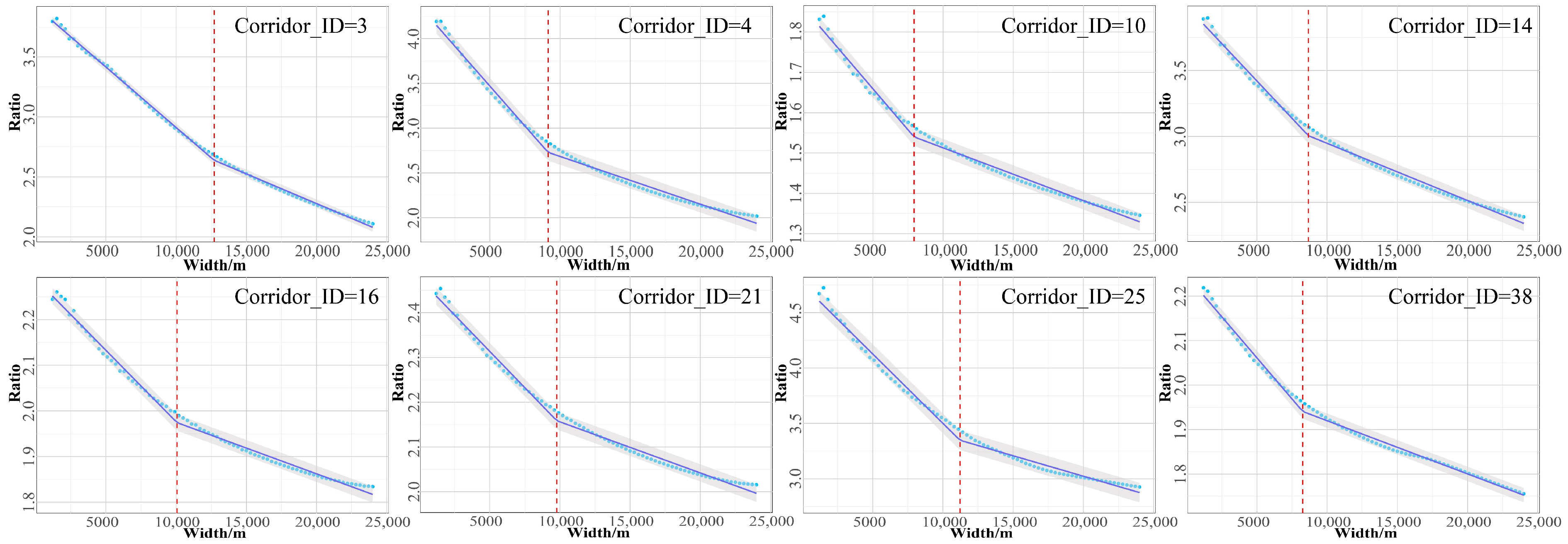
This study employed circuit theory to develop railway heritage corridors, emphasizing functional connectivity for spatial delineation. Using Circuitscape in pairwise mode, global functional connectivity across the study area was assessed, measuring the heritage recreation probability via current density. Circuitscape evaluates all nodes (i.e., heritage sources) pairwise by linking one node in each pair to a 1 A constant current source while grounding the other, iteratively processing all pairs to produce a current density map wherein elevated values signify a higher probability of heritage recreation. Differing from centrality mapper analysis focusing on corridor centrality, this section prioritizes delineating the corridor lateral extent based on functional connectivity. Specifically, using the LCPs derived in Section 2.5, multi-ring buffers were constructed with 300 m steps covering 1200–24,000 m distances. For each buffer, the cumulative current density within the corridor and surrounding areas was calculated, with their ratio designated as the average current density (ACD). Piecewise linear regression was used to examine the ACD curve for each corridor, detect the initial inflection point, and establish the corresponding buffer width as the reference width for railway heritage corridor development [55]. The calculation formula is as follows:
A C D = I + β 1 W i ,   W i < r 1 + β 1 r + β 1 + β 2 W i r ,   W i r
where ACD is the average current density of a specific corridor; Wi is the width of the corridor; I is the intercept of the first segment in the regression model; β 1 is the slope of the first segment in the linear regression; β 2 is the slope difference for the second segment in the linear regression; and r is the inflection point that serves as the reference width.

3. Results

3.1. Distribution of Railway Heritage Sources

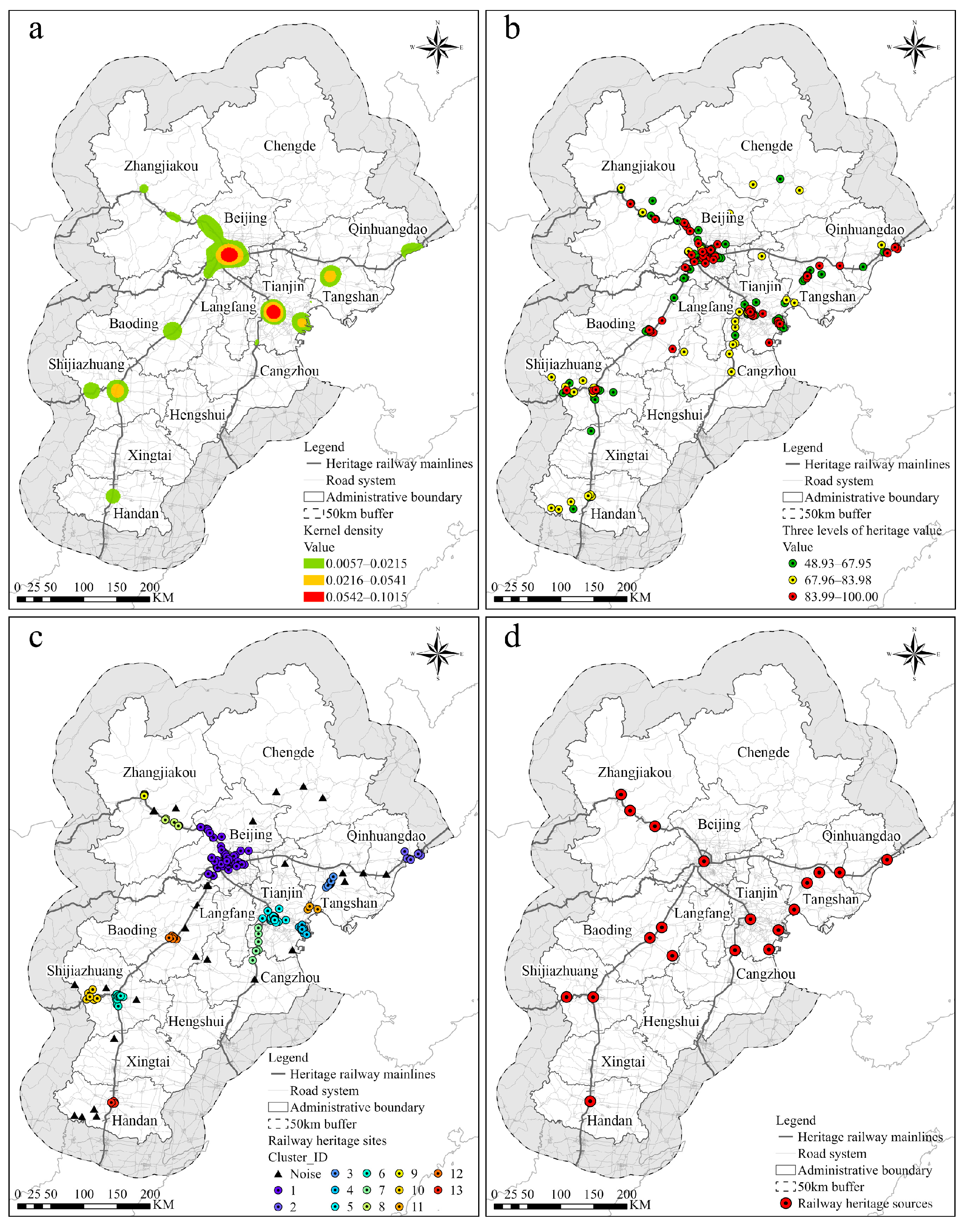
The spatial distribution of railway heritage sites in the BTH region exhibited unevenness, characterized by a distinct pattern of widespread dispersion coupled with localized concentration (Figure 3a). Based on kernel density estimation, Jenks was employed to categorize heritage concentration zones into three tiers: high density (0.0542–0.1015), medium density (0.0216–0.0541), and low density (0.0057–0.0215). Two high-density heritage concentration zones spanned the central urban districts of Beijing (Dongcheng, Xicheng, Chaoyang, Haidian, Fengtai, and Shijingshan) and Tianjin (Heping, Hedong, Hexi, Nankai, Hebei, and Hongqiao). These areas, functioning as core nodes within the historical railway network, encompass significant railway and associated industrial heritage. Five medium-density heritage concentration zones extended across the border region between Yanqing and Changping districts in Beijing, the central-eastern part of the Tianjin Binhai New Area, the central urban districts of Tangshan (Lunan, Lubei, Kaiping, and Fengnan), the central urban districts of Shijiazhuang (Chang’an, Qiaoxi, Xinhua, and Yuhua), and the central urban districts of Baoding (Lianchi and Jingxiu). These regions typically functioned as key stations or industrial bases along the historical railway network. Several low-density heritage concentration zones are distributed across the midwestern part of Jinghai District in Tianjin, Jingxing County in Shijiazhuang, the border area between the Haigang and Shanhaiguan districts in Qinhuangdao, the border region between Xuanhua, Xiahuayuan, and Huailai in Zhangjiakou, and the central urban districts of Handan (Congtai, Hanshan, and Fuxing).
Based on the heritage value assessment, sites were classified into 70 first-level, 66 second-level, and 125 third-level categories (Figure 3b). First-level sites, representing the highest heritage value, prioritize authenticity preservation through strict intervention controls to maintain original historical fabric and structural integrity. Second-level sites adopt adaptive reuse strategies, permitting moderate functional updates while preserving primary structures and core components. Third-level sites implement cluster-based integrated protection, utilizing thematic linkages and functional complementarity among multiple sites to enhance collective protection efficacy. This hierarchical framework ensures that intervention stringency corresponds to heritage significance: first-level sites demand maximum restrictions to safeguard irreplaceable authenticity, while third-level sites leverage network synergies to strengthen the overall heritage landscape. Prioritized allocation of human and material resources to first- and second-level sites is recommended to enhance protection and reuse efficiency across the railway heritage system.
To further identify the spatial clustering characteristics of railway heritage, this study employed the DBSCAN algorithm, identifying 13 heritage clusters and 28 noise points (Figure 3c). Noise points denote spatially isolated heritage sites that fail to satisfy the clustering criteria, predominantly distributed in peripheral cities such as Chengde and Xingtai. The results revealed that heritage clusters exhibited spatial organization radiating from Beijing and Tianjin along railway mainlines, reflecting the railway network’s pivotal role in structuring regional urban development and heritage concentration patterns. Recognizing the analytical value of these isolated sites in elucidating historical distribution patterns and the spatial evolution of railway heritage, the 28 noise points were systematically evaluated using the heritage value assessment framework. This evaluation identified six primary-level heritage sites, which were incorporated into the heritage source network to ensure integration of both clustered and dispersed resources for comprehensive regional coverage. The final network comprised 19 core heritage sources derived from cluster centers and selected noise points including the Zhangjiakou Station, Kailuan Tangshan Mine Early Industrial Remains, and the Zhengfeng Mine Industrial Building Complex (Figure 3d).

3.2. Spatial Patterns of Comprehensive Resistance Surface

This study employed OPGD to assess the influence of various resistance factors on the spatial distribution of heritage sites and determine the weight coefficients for each factor (Table 3) to precisely reflect the impact of spatial resistance on route planning. The results demonstrate that public service factors exerted a significantly stronger influence on the spatial distribution of heritage sites than transportation or natural environmental factors. Specifically, the kernel density of POI, such as tourist attractions (0.7083), dining locations (0.5842), and hotels (0.6397), exhibited high influence, underscoring the substantial dependence of heritage recreation on cultural vitality and accommodation infrastructure, which play a critical role in enhancing the visitor experience and heritage utilization efficiency. Among the transportation factors, road density showed the highest influence (0.6049), confirming the pivotal role of transportation network development in shaping heritage site distribution, as convenient transportation effectively enhances regional accessibility and attractiveness. However, the influence differs across road grades, with distance to tertiary roads (0.0076) and secondary roads (0.0115) exhibiting lower influence, indicating that lower-grade roads provide limited support for heritage recreation. In contrast, natural environmental factors generally exert less influence, with the distance to rivers (0.0058) demonstrating the least impact. This indicates that although rivers historically served as vital transportation links alongside railways, their spatial influence on heritage site distribution has weakened because of modern transportation systems, which have largely superseded river navigation. Furthermore, the influence of elevation and slope was lower than expected, primarily because the study area is located predominantly on flat terrain, where variations in elevation and slope remain minimal, resulting in a limited effect on heritage distribution.
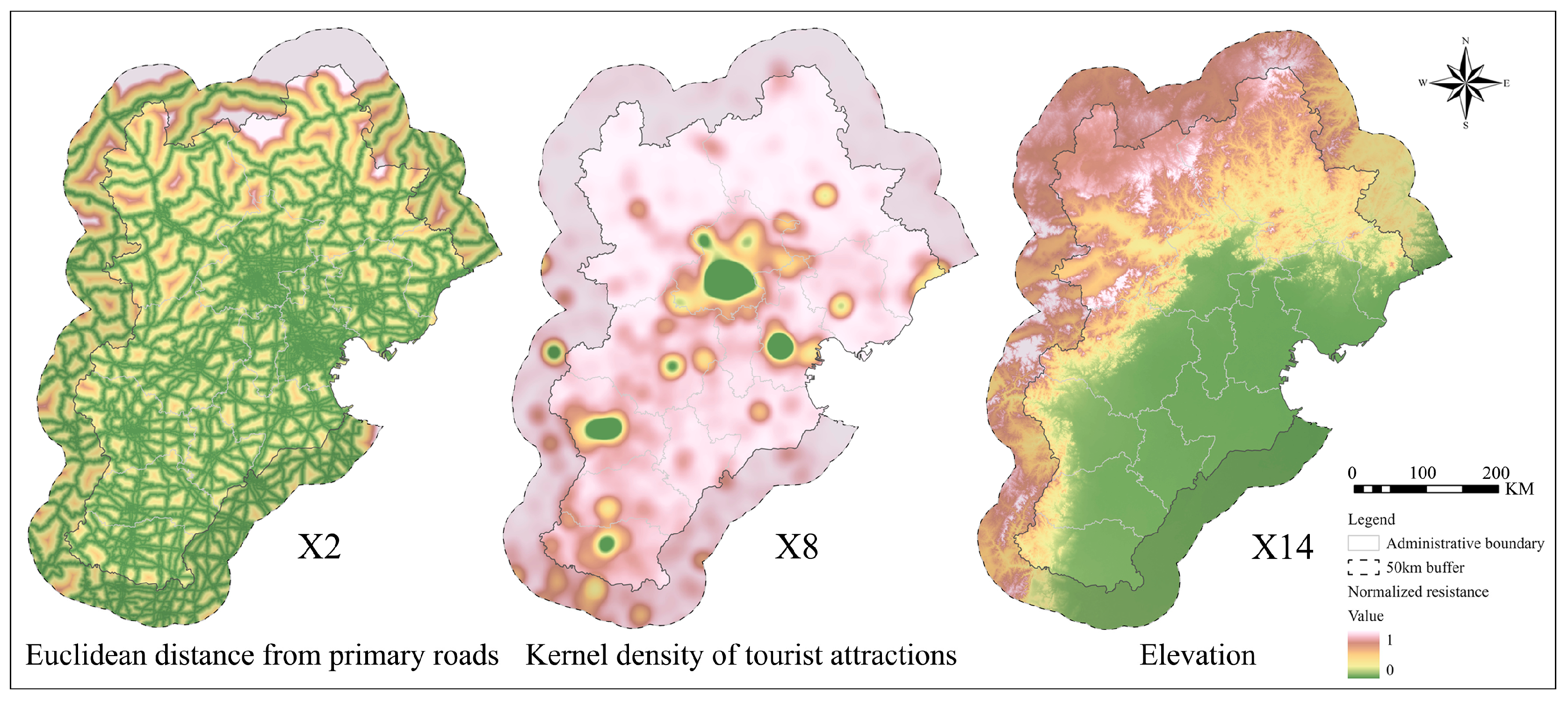
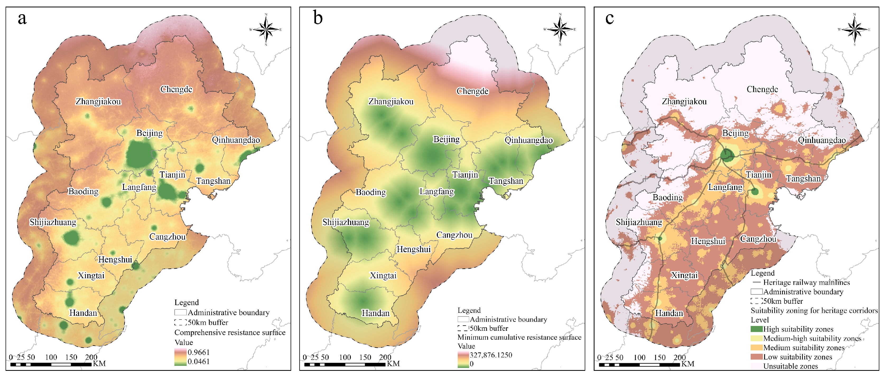
Using weight coefficients, an overlay analysis of the 17 individual resistance surfaces (Figure 4) was performed to create a comprehensive resistance surface for the railway heritage corridor (Figure 5a). The comprehensive resistance values across the study area ranged from 0.0461 to 0.9661, with a mean of 0.8470, thus revealing notable spatial variation and a general trend of higher values in the northwest and lower values in the southeast. High-resistance areas were primarily situated in the Taihang and Yanshan mountain ranges, spanning Zhangjiakou, Chengde, and northwestern Baoding, and are marked by significant topographic relief and elevation variations. In these areas, the prevailing land-use types (forests and grasslands) were linked to high ecological sensitivity, resulting in considerable costs in constructing the heritage corridor. Conversely, low-resistance areas were broadly distributed across the central and eastern cities of the North China Plain, such as Beijing, Tianjin, Tangshan, Qinhuangdao, and Shijiazhuang, where the terrain remains predominantly flat. These regions are primarily characterized by cultivated land and artificial surfaces, exhibiting a high level of urbanization that supports favorable conditions for the development of heritage recreation.
Employing Jenks, the comprehensive resistance surface was categorized into high suitability zones (0.0462–0.5007), medium-high suitability zones (0.5008–0.7208), medium suitability zones (0.7209–0.8073), low suitability zones (0.8074–0.8543), and unsuitable zones (0.8544–0.9661), generating a gradient suitability pattern for railway heritage corridor construction (Figure 5c), which enables the implementation of targeted development strategies based on the distinct characteristics of each zone. The results indicate that suitable zones for corridor construction (encompassing high-, medium-, and medium-suitability zones) spanned 49,368 km2, accounting for 14.87% of the total study area, and exhibited a distribution pattern defined by three core regions and one linear domain. The three core regions were situated in the central urban districts of Beijing, Tianjin, and Shijiazhuang, whereas the linear domain stretched across cities along the Beijing-Hankou and Tianjin-Pukou railway mainlines, displaying a typical linear orientation and serving as the primary spatial framework for potential heritage corridors. These areas benefit from well-developed transportation networks, comprehensive public service facilities, and a relatively concentrated distribution of heritage sites, facilitating contiguous corridor development and the extensive promotion of recreational activities, thereby maximizing the social and economic benefits of heritage sites. In contrast, unsuitable zones for corridor construction covered 172,153 km2, constituting 51.84% of the total study area, and were primarily located in the ecologically fragile mountainous regions of the west and north, where conservation should be prioritized, with only moderate development of small-scale, low-impact heritage recreation to balance ecological protection and tourism development, fostering a harmonious interaction between natural landscapes and railway heritage sites. Furthermore, the low suitability zones spanned 109,348 km2, accounting for 33.29% of the study area and were widely distributed across the central and eastern plains. Despite possessing relatively robust transportation and public service infrastructure, these zones face constraints because of the sparse distribution of heritage sites, which limits their development potential. This necessitates leveraging the radiating influence of the railway heritage corridors and integrating additional tourism resources to promote collaborative development, strengthen the corridors’ axial effects, and stimulate urban renewal.

3.3. Construction of Railway Heritage Corridors Based on Suitability Analysis

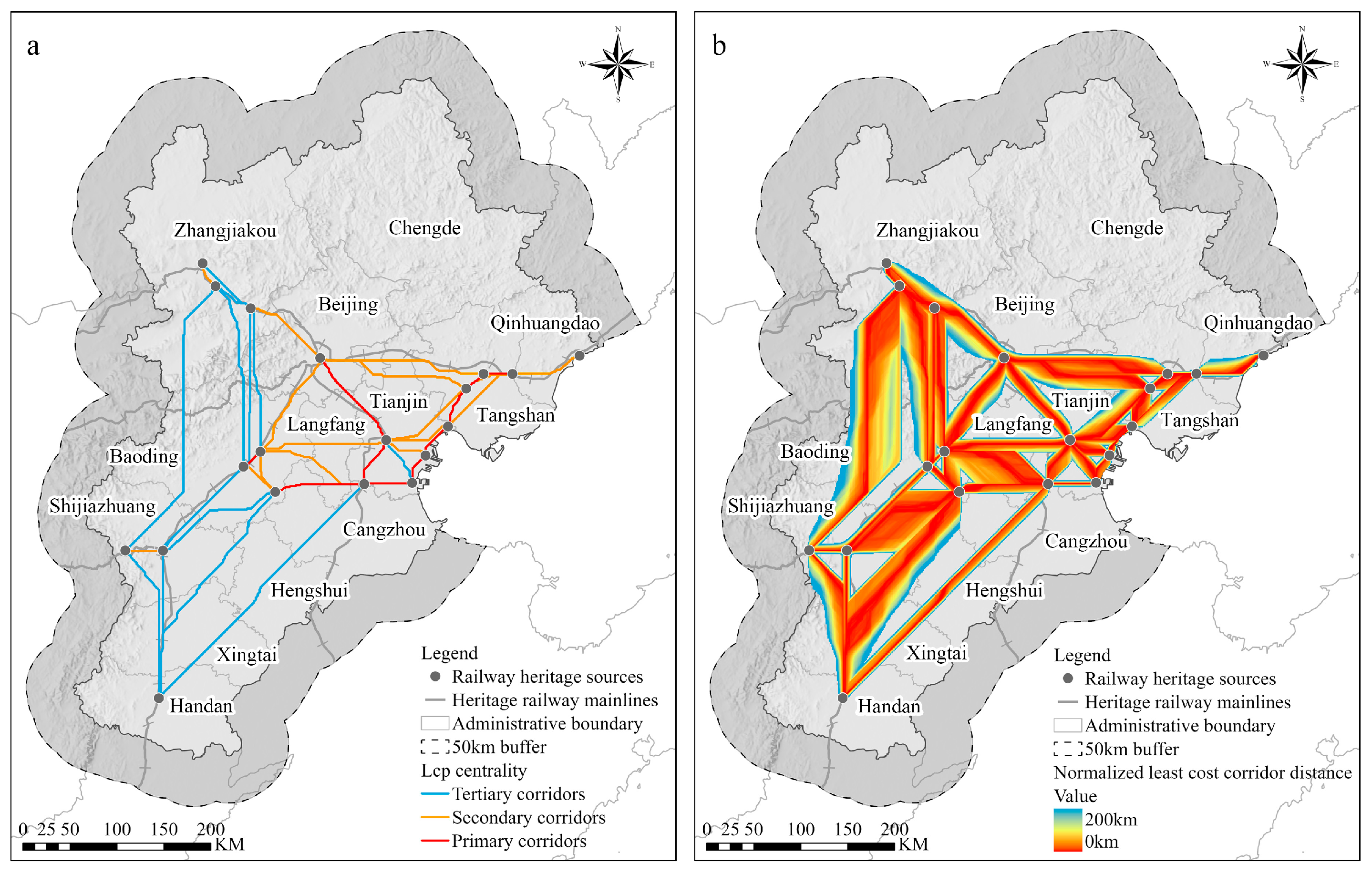
Based on the centrality analysis results of heritage corridors, this study employed Jenks to classify the 42 identified corridors into three hierarchical levels, with higher levels indicating greater importance in sustaining overall network connectivity (Figure 6a). These potential heritage corridors spanned lengths from 24.63 km to 321.76 km, with a mean length of 111.48 km. The mean centrality value was 16.0706. Centrality distribution analysis revealed pronounced hierarchical differentiation: primary corridors (n = 11) exhibited centrality values ranging from 18.5096 to 29.5679 (mean = 22.7606), secondary corridors (n = 15) ranged from 13.8197 to 18.0000 (mean = 16.5885), and tertiary corridors (n = 16) displayed values from 7.2419 to 13.2667 (mean = 10.9856). This concentration of network connectivity within a limited subset of corridors, coupled with sparse distribution in western and southern regions, indicates relatively limited network resilience, where disruption to key primary corridors could substantially fragment the heritage network.
Spatially, the corridor network forms a polycentric radiating structure fundamentally defined by four historical railway mainlines: Beijing-Zhangjiakou, Beijing-Mukden, Beijing-Hankou, and Tianjin-Pukou. Topological overlay of the contemporary railway network with the historical heritage network revealed that 32 corridors were either parallel or overlapped with existing railway lines. Notably, heritage corridors in the Beijing-Zhangjiakou section aligned with the Beijing-Zhangjiakou railway for a cumulative length of 167.42 km, reflecting strong synergy between corridor routing and modern transportation infrastructure. Primary and secondary corridors were concentrated in the central-eastern region encompassing Beijing, Tianjin, and Tangshan, where dense heritage distribution and robust transportation networks have fostered a complex interconnected system, with high centrality values ranging from 13.8197 to 29.5679 across both levels. Conversely, tertiary corridors predominated in the western and southern regions including Zhangjiakou, Shijiazhuang, Baoding, and Handan. Mountainous terrain in Zhangjiakou constrained corridor development along the Beijing-Zhangjiakou railway alignment, while lower heritage site density in southwestern areas resulted in sparser corridor distribution.
Furthermore, under the same cost–distance threshold, the corridor area extracted in the southeastern region surpassed that in the northwestern region (Figure 6b), indicating that resistance to corridor construction was lower in the southeastern region than in the northwestern region. This spatial pattern reflects fundamental geographical and historical characteristics of the BTH railway heritage distribution. The southeastern region, encompassing Beijing, Tianjin, and Tangshan, developed as the primary zone of China’s early railway network during the late Qing Dynasty and Republican era, was characterized by lower topographical relief, higher urbanization levels, and concentrated heritage site distribution. Conversely, the northwestern region, dominated by the Taihang and Yanshan mountain ranges, exhibited elevated terrain complexity and lower heritage density, resulting in substantially higher spatial resistance. Railway construction in this region historically served mineral resource extraction and transportation, with alignments such as the Kaiping Colliery Tramway prioritizing routes through less resistant southeastern terrain to establish efficient linkages between mining areas, urban centers, and ports. This historical development pattern provides essential context for contemporary railway heritage corridor planning.
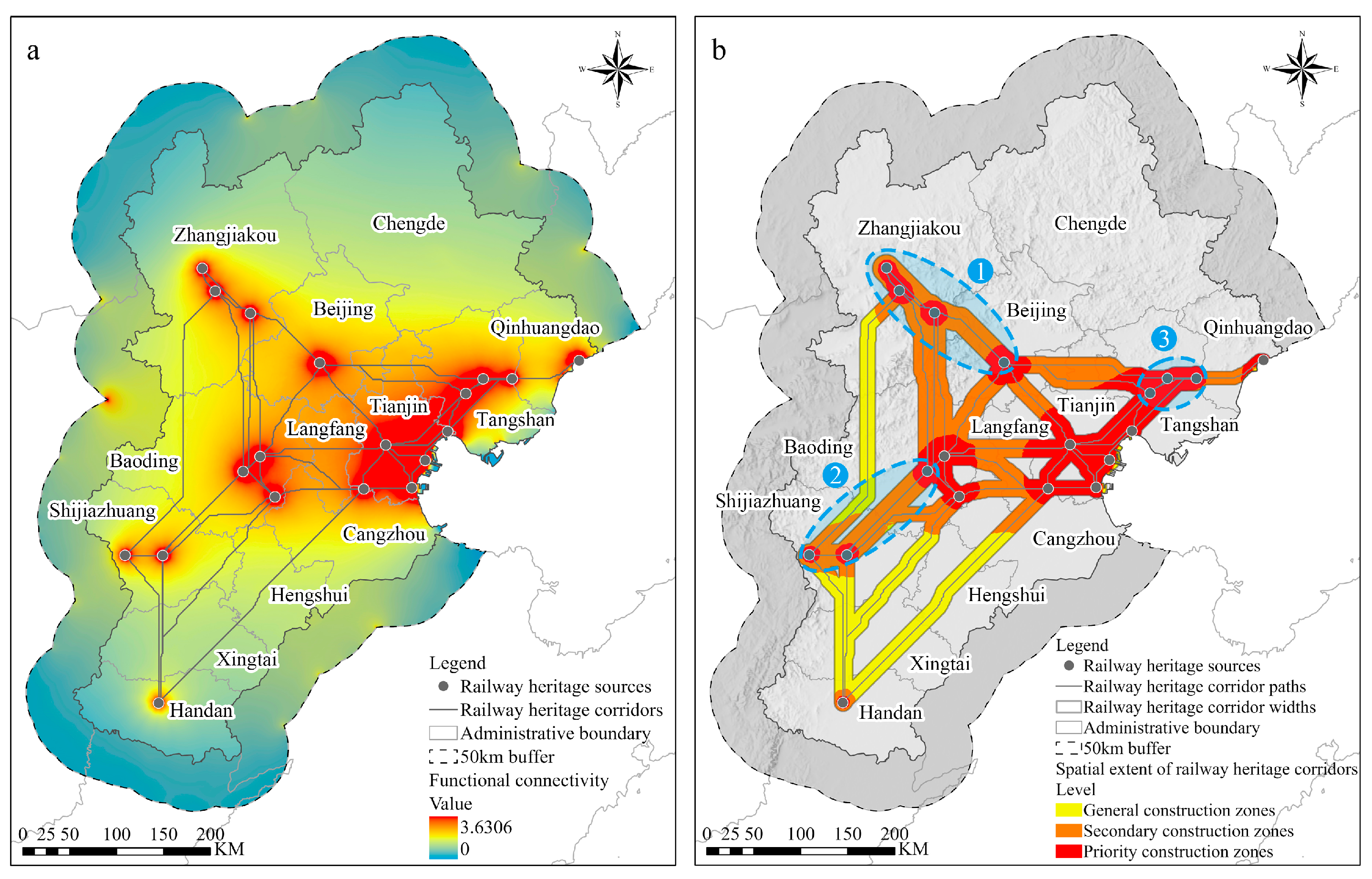
Employing the pairwise mode of Circuitscape to assess global functional connectivity (Figure 7a), the results indicated that the maximum current density in the study area reached 3.6306, with an average current density of 0.0651, and the central and eastern regions exhibited notably higher current densities than the peripheral areas. Furthermore, a piecewise linear regression model was used to determine the reference width for constructing each railway heritage corridor (Figure 7b), revealing that variations in environmental resistance caused different rates of slope decline across regions, resulting in distinct corridor widths (Figure 8). Corridor widths spanned from a maximum of 14.60 km to a minimum of 5.91 km, with a mean of 9.24 km, and corridors in the central and eastern regions, where functional connectivity was higher, predominantly ranged between 7.00 km and 12.71 km. Notably, corridors with greater widths were primarily distributed across three key sections: the Beijing Datum Point Site–Zhangjiakou Shacheng Winery–Xuanhuafu Station–Zhangjiakou Station section (Figure 7b—1), Baoding Film Factory–Shijiazhuang Dashiqiao–Zhengfeng Mine Industrial Building Complex section (Figure 7b—2), and the Kailuan Tangshan Mine Early Industrial Remains–Kailuan Zhaogezhuang Mine–Luan River Iron Bridge section (Figure 7b—3), with an average width of 13.07 km.
The total area allocated for the heritage corridor construction spanned 54,399.42 km2. By employing the quantile classification method, the current density was categorized into three tiers to define the internal spatial hierarchy of the corridor construction area [56,57]. Areas exhibiting current densities ranging from 0.1424 to 3.6306 were designated as priority construction zones (17,950.14 km2), those with values between 0.0854 and 0.1423 were designated as secondary construction zones (23,131.35 km2), and the remaining areas were designated as general construction zones (13,317.93 km2). Together, the priority and secondary construction zones encompassed 222 heritage sites, representing 85.06% of the total, suggesting that these zones possessed both elevated functional connectivity and a high density of heritage sites. These zones play a pivotal role in the development of railway heritage corridors. General construction zones that leverage the abundant surrounding heritage resources can cultivate new cultural growth poles through integration and innovation, thereby broadening the spatial influence of heritage corridors. By developing railway heritage corridors using hierarchical and zoned strategies, the spatial tiers and functional attributes of these corridors can be accurately delineated. This approach establishes a clearly defined and functionally complementary spatial pattern, offering a valuable framework for railway heritage conservation and the integrated advancement of cultural tourism.

4. Discussion

4.1. Optimization of the Route Planning Method for Railway Heritage Corridors

This study addressed critical methodological limitations in heritage corridor construction by integrating OPGD with the MCR model to establish objective, data-driven resistance surface construction protocols. Previous studies have predominantly relied on expert judgment to assign weights to resistance factors in the MCR model [26,45], commonly employing AHP or Delphi methods. While these approaches introduce quantifiable standards, recent comparative analyses revealed that they remain fundamentally constrained by subjective expert preferences in determining factor weights, thereby limiting the objectivity and precision of outcomes [58]. This subjectivity becomes particularly problematic in complex urban built environments where railway heritage embodies both the historical attributes of industrial heritage [48] and the linear features of transportation infrastructure [13]. In such contexts, regeneration potential is shaped by multidimensional factors including transportation accessibility, public service facilities, and natural environmental conditions [19].
This study employed the OPGD factor detector to quantitatively assess the differential impacts of resistance factors on heritage site spatial distribution patterns, establishing data-driven weights that substantially reduce the subjectivity inherent in conventional expert-dependent approaches [25]. Recent advances in spatial heterogeneity analysis have demonstrated that parameter optimization processes can extract geographic characteristics more effectively than traditional empirical discretization methods. The OPGD represents a significant methodological progression beyond AHP-based weighting schemes through its systematic evaluation of discretization parameters [51]. This quantitative factor detection methodology directly addresses the limitations documented in recent heritage corridor literature, where inconsistent resistance factor selection and arbitrary weighting schemes reflect the absence of standardized analytical protocols [34].
The resulting networked spatial configuration demonstrates fundamental advantages over the conventional single-line “axis extension” model prevalent in linear heritage conservation. Recent research emphasizes that heritage corridors exhibiting network resilience through multipath connectivity structures can maintain functional integrity despite localized disruptions [59]. The study’s integrated approach generated a polycentric radiating structure characterized by interconnected loops and multipath synergy, particularly evident in the Beijing-Tianjin-Tangshan core regions where multiple heritage sources form redundant linkages. This network architecture substantially enhances system-level resilience by distributing connectivity across alternative pathways. This design contrasts markedly with rigid linear corridors that function primarily as protective buffers around predetermined railway alignments [18]. Multipath configurations enable dynamic rerouting capacity when individual corridors face disruption, thereby ensuring continuous heritage recreation accessibility [60]. Furthermore, the networked design facilitates flexible recreational route selection and diversified tourism product development, overcoming the spatial limitations of inflexible single-line approaches. This advancement represents a paradigm shift from localized protective buffering to systemic connectivity optimization, establishing reproducible frameworks for cross-regional heritage network development under complex metropolitan urbanization contexts.

4.2. Methodological Advancement in Delineating Spatial Extent of Railway Heritage Corridors

Traditional approaches to heritage corridor width determination exhibit fundamental methodological limitations that compromise their applicability in heterogeneous landscapes. Fixed-width buffer methods commonly employ uniform distance thresholds [32], lacking functional justification for their spatial extent. While the MCR model has become the dominant paradigm for heritage corridor construction, this approach predominantly focuses on corridor route generation rather than systematic width delineation, leaving the critical question of spatial extent inadequately addressed.
This study addressed these critical gaps by integrating circuit theory with piecewise linear regression to establish a quantitative framework for corridor width determination. Circuit theory models landscape connectivity through principles analogous to electrical current flow, where current density reflects the probability of movement across heterogeneous landscapes [33]. Unlike conventional least-cost methods that identify singular optimal pathways, circuit-based approaches naturally generate multiple alternative routes emerging from resistance surfaces, thereby capturing the redundancy essential for system resilience under dynamic urban development pressures [41,52]. This probabilistic framework aligns with recreational mobility patterns observed in heritage tourism contexts, where visitors exercise autonomy in route selection and engage with multiple pathway options rather than following predetermined trajectories [61,62]. Empirical studies demonstrate that effective corridor networks accommodate diverse user needs and activity patterns through distributed accessibility and flexible spatial configurations [63], validating circuit theory’s emphasis on distributed connectivity over discrete pathway assumptions.
The piecewise linear regression model identifies critical thresholds where functional connectivity characteristics undergo fundamental transitions [54]. Specifically, the model detects slope transition points where the average current density exhibits shifts from rapid to gradual decline with increasing buffer width. These inflection points represent thresholds beyond which marginal increases in corridor width yield progressively diminishing functional connectivity improvements, enabling spatially adaptive corridor delineation calibrated to segment-specific resistance characteristics. This breakpoint analysis provides statistical rigor for threshold identification, with inflection points serving as statistically determined thresholds rather than arbitrary expert judgments or subjective buffer zone selections prevalent in conventional methodologies.
Building upon these quantitative foundations, this study established a three-tiered construction zoning system comprising priority, secondary, and general zones, representing a substantive advancement beyond conventional binary core-buffer models [30]. This hierarchical framework derives systematically from current density distributions through quantile classification, enabling the construction of functionally differentiated spatial structures that capture fine-scale variations in connectivity gradients and provide an operational framework for spatially adaptive heritage corridor management.

4.3. Guidance on the Construction of Railway Heritage Corridors in Metropolitan Areas

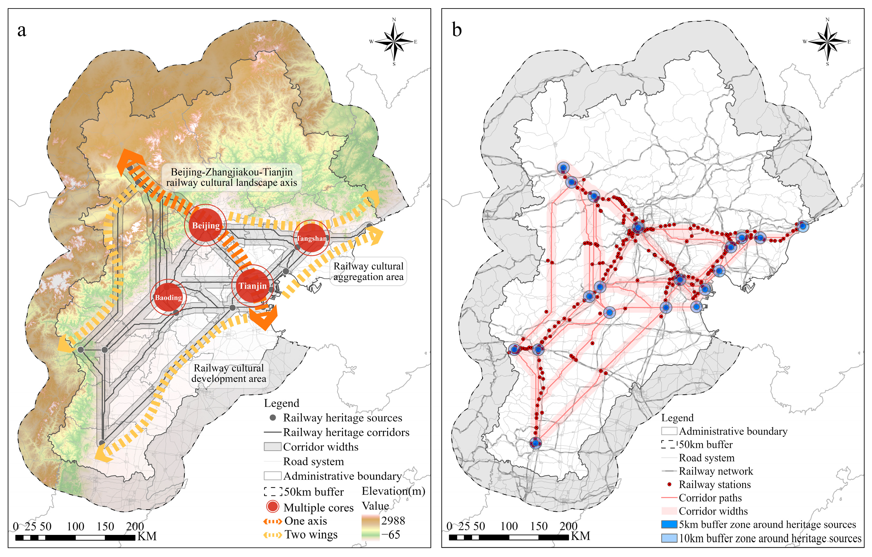
In metropolitan areas with scarce land resources and uneven public service distribution, optimizing existing urban infrastructure and cultural heritage to reduce the corridor construction costs is essential for effective planning implementation [64]. This study proposes a railway heritage development pattern defined by one axis, multiple cores, and two wings (Figure 9a), integrating spatial correlation, functional complementarity, and the development synergy of heritage resources across the BTH region. Furthermore, this study established a trinity support system comprising spatial coupling, functional iteration, and collaborative management, leveraging the material foundation and service efficiency of the existing railway network.

4.3.1. Spatial Coupling: Topological Overlay of Railway Network and Heritage Corridors

During railway heritage corridor construction, integrating transportation functions is essential for balancing heritage preservation with regional development. The “one axis, multiple cores, two wings” pattern demonstrates railway infrastructure’s support for heritage redevelopment (Figure 9b).
The “one axis” comprises the Beijing-Zhangjiakou-Tianjin railway cultural landscape axis, utilizing historical remnants of the Beijing-Zhangjiakou and Tianjin-Pukou railways as material foundation while integrating modern projects (Beijing-Zhangjiakou High-Speed Railway, Beijing Suburban Railway S2 Line, Beijing Modern Tram Xijiao Line, Beijing-Tianjin Intercity Railway). This axis extends from Zhangjiakou through Beijing to Tianjin southeastward, connecting the Great Wall Cultural Belt and Grand Canal Cultural Belt. With 72% of 125 heritage nodes within 3 km of existing stations, this axis enables the maximum utilization of rail transit passenger flow for heritage tourism. Priority should be given to the development of high-grade corridors closely connected to this axis including the Beijing Datum Point Site–Zhangjiakou Shacheng Winery–Xuanhuafu Station–Zhangjiakou Station section and the Beijing Datum Point Site–Former Belgian Tianjin Electric Tramway Company–Tangguantun Railway Station and Iron Bridge section.
The “multiple cores” comprising Beijing, Tianjin, Tangshan, and Baoding leverage unique railway heritage endowments and hub station advantages to form multidimensional dynamic nodes within the heritage network. Major stations concentrate approximately 25% of regional heritage sites within a 5 km radius, confirming the clustering effect of the railway network on heritage distribution. This structure enhances regional synergy, promoting the integration of economic and cultural development along the corridor. Tangshan should coordinate with Tianjin on the Former Belgian Tianjin Electric Tramway Company–Kailuan Tangshan Mine Early Industrial Remains–Kailuan Zhaogezhuang Mine-Luan River Iron Bridge section; Baoding should coordinate with Shijiazhuang on the Baoding Film Factory–Shijiazhuang Dashiqiao-Zhengfeng Mine Industrial Building Complex section.
The “two wings” encompass the northern and southern regions. The northern wing consolidates cultural tourism resources, aligning with the Zhangjiakou-Chengde Tourist Railway plan to establish cultural aggregation hubs. The southern wing extends toward the Shanxi-Hebei border via the Shijiazhuang-Taiyuan Passenger Line, enhancing inter-provincial cooperation. This model, integrating one axis, multiple cores, and two wings with hierarchical preservation strategies, facilitates optimized resource allocation and provides replicable pathways for heritage corridor construction in other metropolitan areas.

4.3.2. Functional Iteration: Activation of Cultural and Tourism Functions at Heritage Sites

Railway heritage corridors must implement differentiated functional transformation strategies aligned with the hierarchical “one axis, multiple cores, two wings” framework to achieve the organic integration of site renewal and network development. For high-value sites along the Beijing-Zhangjiakou-Tianjin cultural axis, including Xizhimen, Zhangjiakou North, and Tianjin West Stations, the preservation of original architectural fabric should be prioritized during functional transformation. Referencing London’s King’s Cross protective redevelopment strategy, these sites integrate cultural exhibition with transportation service functions while maintaining architectural texture, converting transit flows into cultural consumption and strengthening the axis’s cultural corridor role. Regional core areas, including the February 7th Locomotive Works, Jinpu Road Xigu Locomotive Factory, and Tangshan Railway Site, should adopt adaptive reuse strategies balancing preservation and innovation. Drawing on Paris’s Musée d’Orsay transformation approach, these sites undergo functional replacement to become multifunctional centers integrating cultural exhibitions, tourism services, and community activities, enhancing the radiating influence of core areas. For lower-value heritage in peripheral regions, ecological transformation through vegetation restoration and public art installation is recommended for linear relics, referencing New York’s High Line model to reshape industrial landscapes. Scattered locomotive components are symbolically displayed as urban sculptures or cultural-creative carriers, leveraging core regional heritage to promote coordinated protection. These differentiated transformation strategies, rooted in network frameworks and individual site values, overcome the limitations of uniform protection models and facilitate functional implementation and sustainable development at the micro level within the macro network context.

4.3.3. Collaborative Management: Cross-Regional Railway Heritage Governance System

Effective heritage corridor governance requires resolving three fundamental challenges: institutional fragmentation across administrative boundaries, implementation gaps between policy design and ground-level execution, and conflicts among diverse stakeholder interests. This study proposes a hierarchical governance framework that progresses from institutional coordination to operational implementation, embedding dynamic monitoring mechanisms and multi-stakeholder collaboration to ensure adaptive and equitable heritage management.
The foundation of this framework lies in establishing cross-jurisdictional institutional coordination. A cross-regional heritage corridor governance committee should be established under the BTH Collaborative Development Leadership Group framework, with sufficient decision-making authority and executive capacity to coordinate railway heritage preservation and utilization across the three jurisdictions and resolve cross-boundary zoning conflicts. This top-level institutional design provides the organizational foundation for subsequent vertical implementation.
Translating institutional coordination into operational practice requires a three-tiered implementation system that bridges policy design and ground-level execution. Municipal authorities overlay research-identified corridor construction zones with urban master plans and incorporate corridor boundaries into regulatory detailed plans aligned with infrastructure development. County authorities formulate land development agreements based on higher-level plans and local development needs, implementing land-use compliance monitoring. Community organizations establish monitoring groups comprising residents, business representatives, and heritage experts to verify zoning boundaries, identify unmapped heritage sites, and report violations, submitting regular reports to county governments for zoning refinement.
Maintaining governance responsiveness within this implementation structure necessitates dynamic monitoring and adjustment mechanisms. Given that corridor boundaries exhibit a higher sensitivity to urban development pressures than construction zone classifications, differentiated monitoring strategies were embedded within the three-tiered system. Annual monitoring at the corridor width level prevents heritage loss and fragmentation from unauthorized development, with key indicators collected via satellite remote sensing, UAV surveys, and ground investigations. Quinquennial strategic evaluations at the construction zone level align with China’s Five-Year Plan framework to assess the heritage preservation quality, economic benefits, and socio-cultural impacts. A cross-departmental information exchange platform integrating cultural heritage, urban planning, and transportation sectors ensures evaluation transparency and result traceability, enabling the timely identification of high-value core areas for prioritized investment.
Sustaining effectiveness depends on reconciling stakeholder interests through collaborative mechanisms. Stakeholder conflicts typically arise from tensions between governmental preservation objectives, enterprise economic interests, and community livelihood concerns. To address these tensions, government agencies establish consultation forums involving heritage, planning, and transportation authorities, alongside enterprise and community representatives. These forums ensure transparent dialogue on project planning, benefit distribution, and conflict resolution. To align market mechanisms with preservation objectives, governments employ differentiated policy instruments calibrated to zoning classifications. Tax incentives and floor area ratio bonuses are proportionally allocated to encourage enterprise investment in core preservation zones while maintaining development flexibility in buffer areas. Revenue-sharing arrangements direct heritage-related economic returns toward community infrastructure and resident welfare programs. This integrated approach reconciles preservation imperatives with economic viability, ensuring sustainable equilibrium between heritage conservation and urban development.

4.4. International Transferability and Limitations

International urban clusters exhibit distinct railway heritage patterns rooted in divergent industrialization pathways and geographical contexts. While the Northeast Megalopolis, Métropole du Grand Paris, Greater London Built-up Area, Pacific Belt, and BTH urban agglomeration share commonalities in dense railway network development through industrialization with heritage resources integrated into urban space, fundamental differences emerge from regional development trajectories. BTH railways originated from colonial resource extraction, with alignments designed to export mineral resources through ports, manifesting resource-oriented spatial logic. The Northeast Megalopolis developed port–railway–canal integrated systems connecting New York harbor to inland hinterlands for bulk commodity trade exhibit trade-oriented patterns. European metropolitan regions including Greater London and Métropole du Grand Paris established radial networks extending from capital cities to peripheral industrial zones for raw material transport, demonstrating industry-oriented configurations. Japan’s Pacific Belt emphasized passenger network integration with urban expansion under constraints of land scarcity and seismic vulnerability, resulting in heritage deeply embedded within dense built environments and presenting population-oriented spatial characteristics.
These orientation-driven patterns have catalyzed diversified adaptive reuse strategies reflecting regional priorities. United States railway heritage conservation prioritizes recreational transformation, exemplified by the 1967 Elroy-Sparta State Trail conversion and subsequent Rails-to-Trails Conservancy frameworks establishing Rail-to-Trail and Rail-with-Trail paradigms that generated nationwide nonmotorized recreational corridor networks. United Kingdom practices emphasize cultural attribute excavation through architectural preservation integrated with functional enhancement, as demonstrated by Liverpool Road Station’s conversion into the Museum of Science and Industry and Sheffield Station’s Victorian architectural preservation combined with modernization upgrades. These international experiences demonstrate that effective railway heritage adaptive reuse requires context-specific calibration to regional development orientations, spatial configurations, and sociocultural demands.
The research paradigm proposed herein demonstrates efficacy within BTH’s complex multilevel governance spanning centrally administered municipalities and provincial units, encompassing megacities, medium-sized urban centers, and extensive rural territories with pronounced built environment heterogeneity. This affirms its adaptability to spatial heterogeneity and intricate policy landscapes. Nonetheless, localized implementation requires resistance factor system calibration aligned with regional contexts. For the Northeast Megalopolis, policy stringency and public engagement factors could capture governmental oversight impacts on heritage corridor development. European metropolitan regions might integrate the cultural significance of industrial heritage and ecological sensitivity factors to examine cultural identity and ecosystem service influences. Pacific Belt contexts could incorporate land tenure complexity and disaster risk exposure factors to evaluate land use intensification and seismic hazard effects on corridor planning. By analyzing distinct cultural contexts and morphological characteristics while adjusting the comprehensive resistance surfaces accordingly, this paradigm strengthens planning adaptability under spatial heterogeneity conditions, offering technical pathways balancing the universality and locality of railway heritage conservation across urban clusters.
To enhance methodological universality, future research should develop parameter selection guidelines tailored to varying regional scales and heritage typologies, complemented by open-source toolkits mitigating implementation barriers. Establishing multiscale validation mechanisms that evaluate heritage network performance at finer administrative levels including municipal and county scales remains imperative. The integration of high-resolution remote sensing data into long-term monitoring systems would facilitate dynamic assessments of implemented corridor effectiveness in attaining conservation and development objectives, ensuring the continuous improvement of planning methodologies under evolving urban development pressures.

5. Conclusions

This study integrated the MCR model with circuit theory to analyze the spatial configuration of railway heritage in the BTH region, establishing a framework that balances conservation and development objectives. At the theoretical level, this research achieves a paradigm shift in railway heritage conservation from isolated dots to networked systems. Conventional research treats railway heritage as discrete entities requiring individual protection through boundaries or buffer zones to shield them from external disturbances. This study transcends this limitation by proposing a clusters–corridors–networks hierarchical framework, emphasizing that conservation effectiveness depends on systemic network resilience rather than individual site integrity. By identifying 19 heritage sources, 42 corridors, and a connectivity network spanning 54,399.42 km2, this research demonstrates that the cultural value of railway heritage resides not merely in the material forms of individual stations or lines, but more fundamentally in the systemic relationships they constitute within transportation networks, industrial systems, and spatial organizations. This theoretical shift from localized protection to systematic integration reconceptualizes heritage corridors as dynamic systems adapted to complex urban built environments, providing a new theoretical perspective for cross-regional heritage conservation under rapid urbanization contexts.
At the methodological level, this study established an objective, quantitative corridor identification technical system, overcoming the limitations of conventional approaches that rely on empirical weighting and fixed buffer zones. The integrated OPGD-MCR-circuit theory workflow achieves dual innovations: first, quantitative factor detection through q-statistics established an objective weighting system addressing subjectivity inherent in conventional AHP approaches; and second, piecewise linear regression identified functional connectivity inflection points to generate an adaptive corridor delineation methodology based on simulated recreational processes, significantly enhancing the capacity to accommodate spatial heterogeneity. At the practical level, this study constructed a spatial management system characterized by core source radiation and multilevel corridor nesting. Through three-tiered construction zoning encompassing priority, secondary, and general zones, this framework transcends binary core-buffer models and proposes differentiated implementation strategies that provide operational decision-making tools for the dynamic protection and functional revitalization of cross-regional heritage sites.
The research findings demonstrate that railway heritage revitalization is essential for cultural preservation and serves as a vital mechanism for fostering urban–rural integration and sustainable development in China’s advancing urbanization context. Railway heritage corridors in the BTH region hold significant social and public value, requiring rational development aligned with regional socioeconomic needs to convert abstract cultural values into tangible economic benefits. This study developed a comprehensive research paradigm for railway heritage corridors, encompassing heritage source selection, resistance surface construction, corridor route planning, spatial scope delineation, and protection strategy formulation. This paradigm substantially strengthens the scientific rigor of corridor planning and addresses the challenges of heritage isolation and inefficient land use. The outcomes rectify shortcomings in the existing quantitative analysis methods for heritage corridors and provide a scientific model for balancing heritage conservation, ecological sustainability, and economic development in metropolitan areas through networked protection and adaptive utilization.

Supplementary Materials

The following supporting information can be downloaded at: https://www.mdpi.com/article/10.3390/land14112139/s1, Table S1: The description of data sources; Figure S1: Construction of the single-factor resistance surface for railway heritage corridor in BTH.

Author Contributions

X.L.: Conceptualization, methodology, and writing; H.X.: Review and editing. All authors have read and agreed to the published version of the manuscript.

Funding

This research was funded by the National Natural Science Foundation of China (grant number: 52578054) and the Beijing Social Science Foundation Major Project (grant number: 22JCA005).

Data Availability Statement

The datasets generated and analyzed during the current study are available from the corresponding author upon reasonable request.

Conflicts of Interest

The authors declare no conflicts of interest. The funders had no role in the design of the study; in the collection, analyses, or interpretation of data; in the writing of the manuscript; or in the decision to publish the results.

References

  1. Martí-Henneberg, J. The Influence of the Railway Network on Territorial Integration in Europe (1870–1950). J. Transp. Geogr. 2017, 62, 160–171. [Google Scholar] [CrossRef]
  2. Pietrzak, K.; Pietrzak, O.; Montwiłł, A. Light Freight Railway (LFR) as an Innovative Solution for Sustainable Urban Freight Transport. Sustain. Cities Soc. 2021, 66, 102663. [Google Scholar] [CrossRef]
  3. Li, X.; Xia, H. Evaluation of the regeneration value of a railway heritage corridor: A case study based on Beijing-Zhangjiakou railway (Beijing section). South Archit. 2023, 3, 40–51. [Google Scholar] [CrossRef]
  4. Ferretti, V.; Degioanni, A. How to Support the Design and Evaluation of Redevelopment Projects for Disused Railways? A Methodological Proposal and Key Lessons Learned. Transp. Res. Part Transp. Environ. 2017, 52, 29–48. [Google Scholar] [CrossRef]
  5. Taylor, T.; Landorf, C. Subject–Object Perceptions of Heritage: A Framework for the Study of Contrasting Railway Heritage Regeneration Strategies. Int. J. Herit. Stud. 2015, 21, 1050–1067. [Google Scholar] [CrossRef]
  6. USA Rails-To-Trails Conservancy (RTC) Website. Available online: https://www.railstotrails.org/about/ (accessed on 8 October 2025).
  7. European Greenways Association (AEVV-EGWA) Website. Available online: https://www.aevv-egwa.org/ (accessed on 8 October 2025).
  8. UK Heritage Railway Association (HRA) Website. Available online: https://www.hra.uk.com/ (accessed on 12 October 2025).
  9. Scherrer, P.; Dimmock, K.; Lamont, M.; Ripoll González, L. Rail Trails Literature: Current Status and Future Research. J. Leis. Res. 2021, 52, 97–119. [Google Scholar] [CrossRef]
  10. Bhati, A.; Pryce, J.; Chaiechi, T. Industrial Railway Heritage Trains: The Evolution of a Heritage Tourism Genre and Its Attributes. J. Herit. Tour. 2014, 9, 114–133. [Google Scholar] [CrossRef]
  11. Ruiz, R.; Rodríguez, J.; Coronado, J.M. Modern Roads as UNESCO World Heritage Sites: Framework and Proposals. Int. J. Herit. Stud. 2017, 23, 362–374. [Google Scholar] [CrossRef]
  12. Oliveira, E.R.D.; Silva, M.M.; Deus, J.D.; Santana Junior, E.; Costa, A.; Lara, A.P.; Santos, B.; Berata, T.; Bueno, V. Social Valuation of Protected Cultural Assets: The Railway Heritage between Jundiaí and Campinas (Brazil). Int. J. Herit. Stud. 2022, 28, 714–732. [Google Scholar] [CrossRef]
  13. Eizaguirre-Iribar, A.; Grijalba, O.; Hernández-Minguillón, R.J. An Integrated Approach to Transportation and Land-Use Planning for the Analysis of Former Railway Nodes in Sustainable Transport Development: The Case of the Vasco-Navarro Railway. Sustainability 2021, 13, 322. [Google Scholar] [CrossRef]
  14. Della Spina, L.; Lanteri, C. A Collaborative Multi-Criteria Decision-Making Framework for the Adaptive Reuse Design of Disused Railways. Land 2024, 13, 851. [Google Scholar] [CrossRef]
  15. Bianchi, A.; De Medici, S. A Sustainable Adaptive Reuse Management Model for Disused Railway Cultural Heritage to Boost Local and Regional Competitiveness. Sustainability 2023, 15, 5127. [Google Scholar] [CrossRef]
  16. Liu, F.; Lu, Z.; Qiang, W. An Innovative Approach to Post-Occupancy Evaluation of Architectural Heritages in the Peking-Mukden Railway. Herit. Sci. 2024, 12, 383. [Google Scholar] [CrossRef]
  17. Modesto, A.; Kamenečki, M.; Tomić Reljić, D. Application of Suitability Modeling in Establishing a New Bicycle–Pedestrian Path: The Case of the Abandoned Kanfanar–Rovinj Railway in Istria. Land 2021, 10, 600. [Google Scholar] [CrossRef]
  18. Rovelli, R.; Senes, G.; Fumagalli, N.; Sacco, J.; De Montis, A. From Railways to Greenways: A Complex Index for Supporting Policymaking and Planning. A Case Study in Piedmont (Italy). Land Use Policy 2020, 99, 104835. [Google Scholar] [CrossRef]
  19. Eizaguirre-Iribar, A.; Grijalba, O. A Methodological Proposal for the Analysis of Disused Railway Lines as Territorial Structuring Elements: The Case Study of the Vasco-Navarro Railway. Land Use Policy 2020, 91, 104406. [Google Scholar] [CrossRef]
  20. Mısırlısoy, D.; Günçe, K. Railways as Common Cultural Heritage: Cyprus Government Railway. Hist. Environ. Policy Pract. 2023, 14, 112–128. [Google Scholar] [CrossRef]
  21. Jurković, Ž.; Hadzima-Nyarko, M.; Lovoković, D. Railway Corridors in Croatian Cities as Factors of Sustainable Spatial and Cultural Development. Sustainability 2021, 13, 6928. [Google Scholar] [CrossRef]
  22. Zhang, Z.; Cao, R.; Kang, F. Spatial and temporal distribution characteristics of the industrial heritage along the Taiyuan-Baijiazhuang railway and analysis of the suitability construction of heritage corridors. J. Arid Land Resour. Environ. 2024, 38, 40–51. [Google Scholar] [CrossRef]
  23. Wang, C.; Ma, Q. Study on the Construction of the Beijing-Tianjin-Hebei Railway Heritage Corridor. J. Cap. Norm. Univ. Sci. Ed. 2017, 3, 71–78. [Google Scholar] [CrossRef]
  24. Conzen, M.P.; Wulfestieg, B.M. Metropolitan Chicago’s Regional Cultural Park: Assessing the Development of the Illinois & Michigan Canal National Heritage Corridor. J. Geogr. 2001, 100, 111–117. [Google Scholar] [CrossRef]
  25. Wang, Q.; Yang, C.; Wang, J.; Tan, L. Tourism in Historic Urban Areas: Construction of Cultural Heritage Corridor Based on Minimum Cumulative Resistance and Gravity Model—A Case Study of Tianjin, China. Buildings 2024, 14, 2144. [Google Scholar] [CrossRef]
  26. Li, H.; Zhang, T.; Cao, X.; Yao, L. Active Utilization of Linear Cultural Heritage Based on Regional Ecological Security Pattern along the Straight Road (Zhidao) of the Qin Dynasty in Shaanxi Province, China. Land 2023, 12, 1361. [Google Scholar] [CrossRef]
  27. Lin, F.; Zhang, X.; Ma, Z.; Zhang, Y. Spatial Structure and Corridor Construction of Intangible Cultural Heritage: A Case Study of the Ming Great Wall. Land 2022, 11, 1478. [Google Scholar] [CrossRef]
  28. Zhou, G.; Huan, Y.; Wang, L.; Lan, Y.; Liang, T.; Shi, B.; Zhang, Q. Linking Ecosystem Services and Circuit Theory to Identify Priority Conservation and Restoration Areas from an Ecological Network Perspective. Sci. Total Environ. 2023, 873, 162261. [Google Scholar] [CrossRef]
  29. Peng, J.; Yang, Y.; Liu, Y.; Hu, Y.; Du, Y.; Meersmans, J.; Qiu, S. Linking Ecosystem Services and Circuit Theory to Identify Ecological Security Patterns. Sci. Total Environ. 2018, 644, 781–790. [Google Scholar] [CrossRef] [PubMed]
  30. Kang, J.; Li, C.; Li, M.; Zhang, T.; Zhang, B. Identifying Priority Areas for Conservation in the Lower Yellow River Basin from an Ecological Network Perspective. Ecosyst. Health Sustain. 2022, 8, 2105751. [Google Scholar] [CrossRef]
  31. Van Schalkwyk, J.; Pryke, J.S.; Samways, M.J.; Gaigher, R. Corridor Width Determines Strength of Edge Influence on Arthropods in Conservation Corridors. Landsc. Ecol. 2020, 35, 1175–1185. [Google Scholar] [CrossRef]
  32. Li, X.; Zhu, R.; Shi, C.; Yang, X.; Chen, J.; Wei, K. Research on the Construction of Intangible Cultural Heritage Corridors in the Yellow River Basin Based on Geographic Information System (GIS) Technology and the Minimum Cumulative Resistance (MCR) Model. Herit. Sci. 2024, 12, 271. [Google Scholar] [CrossRef]
  33. Wu, J.; Li, C.; Wang, T. Optimizing Landscape Patterns for Tea Plantation Agroecosystems: A Case Study of an Important Agricultural Heritage System in Enshi, China. Land 2025, 14, 1491. [Google Scholar] [CrossRef]
  34. Lin, Z.; Li, B. Circuit Theory-Based Cultural Heritage Corridor Network Development in Qin River Basin. Npj Herit. Sci. 2025, 13, 385. [Google Scholar] [CrossRef]
  35. McRae, B.H.; Dickson, B.G.; Keitt, T.H.; Shah, V.B. Using Circuit Theory to Model Connectivity in Ecology, Evolution, and Conservation. Ecology 2008, 89, 2712–2724. [Google Scholar] [CrossRef] [PubMed]
  36. McRae, B.H.; Beier, P. Circuit Theory Predicts Gene Flow in Plant and Animal Populations. Proc. Natl. Acad. Sci. USA 2007, 104, 19885–19890. [Google Scholar] [CrossRef] [PubMed]
  37. Baguette, M.; Blanchet, S.; Legrand, D.; Stevens, V.M.; Turlure, C. Individual Dispersal, Landscape Connectivity and Ecological Networks. Biol. Rev. 2013, 88, 310–326. [Google Scholar] [CrossRef] [PubMed]
  38. Willemen, L.; Hein, L.; Van Mensvoort, M.E.F.; Verburg, P.H. Space for People, Plants, and Livestock? Quantifying Interactions among Multiple Landscape Functions in a Dutch Rural Region. Ecol. Indic. 2010, 10, 62–73. [Google Scholar] [CrossRef]
  39. Huang, L.; Chen, Z.; Yang, Z.; Chen, M.; Chen, X.; Zhai, T.; Qiu, T. Integrating “Quality-Risk-Demand” Framework and Circuit Theory to Identify Spatial Range and Priority Area of Ecological Security Pattern in a Rapidly Urbanizing Landscape. Ecol. Inform. 2024, 82, 102673. [Google Scholar] [CrossRef]
  40. Koen, E.L.; Garroway, C.J.; Wilson, P.J.; Bowman, J. The Effect of Map Boundary on Estimates of Landscape Resistance to Animal Movement. PLoS ONE 2010, 5, e11785. [Google Scholar] [CrossRef]
  41. Su, J.; Kong, F.; Yin, H.; Meadows, M.; Zhou, K.; Li, Z.; Cui, H. Past, Present and Future Climate Connectivity Informs Conservation Strategies in the Yangtze River Delta Urban Agglomeration, China. Landsc. Urban Plan. 2023, 240, 104894. [Google Scholar] [CrossRef]
  42. Yang, J.; Dong, J.; Xiao, X.; Dai, J.; Wu, C.; Xia, J.; Zhao, G.; Zhao, M.; Li, Z.; Zhang, Y.; et al. Divergent Shifts in Peak Photosynthesis Timing of Temperate and Alpine Grasslands in China. Remote Sens. Environ. 2019, 233, 111395. [Google Scholar] [CrossRef]
  43. Feng, Y.; Wei, H.; Huang, Y.; Li, J.; Mu, Z.; Kong, D. Spatiotemporal Evolution Characteristics and Influencing Factors of Traditional Villages: The Yellow River Basin in Henan Province, China. Herit. Sci. 2023, 11, 97. [Google Scholar] [CrossRef]
  44. Ester, M.; Kriegel, H.-P.; Sander, J.; Xu, X. A Density-Based Algorithm for Discovering Clusters in Large Spatial Databases with Noise. In Proceedings of the Second International Conference on Knowledge Discovery and Data Mining, Portland, OR, USA, 2–4 August 1996; AAAI Press: Portland, OR, USA, 1996; pp. 226–231. [Google Scholar]
  45. Sun, Y.; Wang, Y.; Liu, L.; Wei, Z.; Li, J.; Cheng, X. Large-Scale Cultural Heritage Conservation and Utilization Based on Cultural Ecology Corridors: A Case Study of the Dongjiang-Hanjiang River Basin in Guangdong, China. Herit. Sci. 2024, 12, 44. [Google Scholar] [CrossRef]
  46. Fan, X.; Wang, Z.; Li, S. Value Evaluation Model (VEM) of Ancient Chinese Military Settlement Heritage: A Case Study of Liaoxi Corridor in the Ming Dynasty. Herit. Sci. 2024, 12, 97. [Google Scholar] [CrossRef]
  47. Knaapen, J.P.; Scheffer, M.; Harms, B. Estimating Habitat Isolation in Landscape Planning. Landsc. Urban Plan. 1992, 23, 1–16. [Google Scholar] [CrossRef]
  48. Xu, L.; Zhang, Z.; Tan, G.; Yuan, L. Research on the Reuse Path of the Third Front Construction Stock Space in China Based on Value Assessment. Front. Archit. Res. 2025, 14, 77–93. [Google Scholar] [CrossRef]
  49. Wang, J.-F.; Zhang, T.-L.; Fu, B.-J. A Measure of Spatial Stratified Heterogeneity. Ecol. Indic. 2016, 67, 250–256. [Google Scholar] [CrossRef]
  50. Wang, J.; Li, X.; Christakos, G.; Liao, Y.; Zhang, T.; Gu, X.; Zheng, X. Geographical Detectors--based Health Risk Assessment and Its Application in the Neural Tube Defects Study of the Heshun Region, China. Int. J. Geogr. Inf. Sci. 2010, 24, 107–127. [Google Scholar] [CrossRef]
  51. Song, Y.; Wang, J.; Ge, Y.; Xu, C. An Optimal Parameters-Based Geographical Detector Model Enhances Geographic Characteristics of Explanatory Variables for Spatial Heterogeneity Analysis: Cases with Different Types of Spatial Data. GIScience Remote Sens. 2020, 57, 593–610. [Google Scholar] [CrossRef]
  52. Huang, L.; Wang, J.; Fang, Y.; Zhai, T.; Cheng, H. An Integrated Approach towards Spatial Identification of Restored and Conserved Priority Areas of Ecological Network for Implementation Planning in Metropolitan Region. Sustain. Cities Soc. 2021, 69, 102865. [Google Scholar] [CrossRef]
  53. Weber, T.; Norman, J. Functional Connectivity Modeling and Optimal Siting of Conservation Networks in the Midwest USA. Ecol. Inform. 2015, 30, 277–283. [Google Scholar] [CrossRef]
  54. Yu, H.; Xiao, H.; Gu, X. Integrating Species Distribution and Piecewise Linear Regression Model to Identify Functional Connectivity Thresholds to Delimit Urban Ecological Corridors. Comput. Environ. Urban Syst. 2024, 113, 102177. [Google Scholar] [CrossRef]
  55. Zhang, L.; Yu, H.; Zhong, Q.; Zhang, G.; Zhang, Q. Research on the Spatial Demarcation of Urban Ecological Corridors Based on Functional Connectivity. Chin. Landsc. Archit. 2024, 40, 6–14. [Google Scholar] [CrossRef]
  56. Dong, J.; Peng, J.; Xu, Z.; Liu, Y.; Wang, X.; Li, B. Integrating Regional and Interregional Approaches to Identify Ecological Security Patterns. Landsc. Ecol. 2021, 36, 2151–2164. [Google Scholar] [CrossRef]
  57. Yin, Y.; Liu, S.; Sun, Y.; Zhao, S.; An, Y.; Dong, S.; Coxixo, A. Identifying Multispecies Dispersal Corridor Priorities Based on Circuit Theory: A Case Study in Xishuangbanna, Southwest China. J. Geogr. Sci. 2019, 29, 1228–1245. [Google Scholar] [CrossRef]
  58. Sun, D.; Wu, X.; Wen, H.; Ma, X.; Zhang, F.; Ji, Q.; Zhang, J. Ecological Security Pattern Based on XGBoost-MCR Model: A Case Study of the Three Gorges Reservoir Region. J. Clean. Prod. 2024, 470, 143252. [Google Scholar] [CrossRef]
  59. Du, C.; Pan, D.; Liu, Q. The Construction of a Protection Network for Traditional Settlements across Regions: A Case Study of the Chengdu–Chongqing Ancient Post Road Heritage Corridor in China. Land 2025, 14, 327. [Google Scholar] [CrossRef]
  60. Ge, Y.; Liu, Y.; Ma, Y.; Wang, Y.; Guo, Y.; He, J.; Mao, Y. Spatial Identification and Corridor Network Analysis of Cultural Heritage Based on Multi-Model Fusion: A Case Study of Western Henan. Ecol. Indic. 2025, 178, 113859. [Google Scholar] [CrossRef]
  61. Yu, H.; Chen, Q.; Hu, X. Tourist interest areas and spatial movement patterns on the Qinghai-Tibet plateau based on dynamic trajectory similarity. Habitat Int. 2025, 163, 103500. [Google Scholar] [CrossRef]
  62. Tian, Z.; Wang, Q.; Liu, Y.; Wang, Z. Comparison of the tourist mobility patterns among demographic subgroups with mobile phone data: A case study of Chongqing, China. Appl. Geogr. 2023, 159, 103090. [Google Scholar] [CrossRef]
  63. Cao, L.; Wang, K.; Zhao, X.; Zhang, Y. Optimizing Composite Ecological Networks through Synergistic Risk Management, Ecological Conservation, and Recreational Integration: A Case Study of Beijing’s Shallow Mountain Regions. Ecol. Indic. 2025, 170, 113026. [Google Scholar] [CrossRef]
  64. Wang, Y.; Qu, Z.; Zhong, Q.; Zhang, Q.; Zhang, L.; Zhang, R.; Yi, Y.; Zhang, G.; Li, X.; Liu, J. Delimitation of Ecological Corridors in a Highly Urbanizing Region Based on Circuit Theory and MSPA. Ecol. Indic. 2022, 142, 109258. [Google Scholar] [CrossRef]
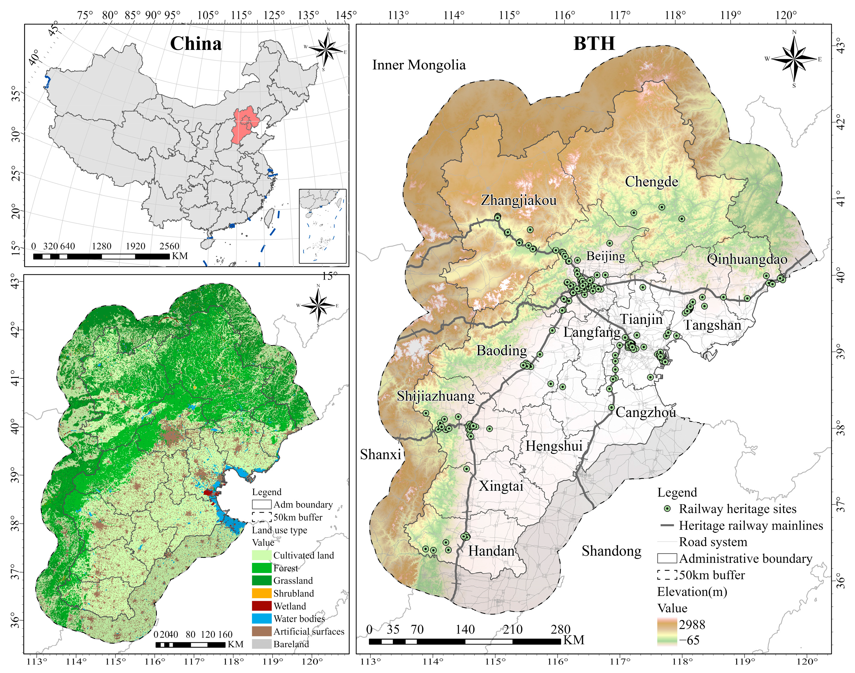
Figure 1. Geographical location of BTH and the spatial distribution of its railway heritage sites.
Land 14 02139 g001
Figure 2. Research framework.
Land 14 02139 g002
Figure 3. Spatial analysis of railway heritage sites in BTH. Panel (a) shows KDE revealing three concentration tiers via Jenks. Panel (b) presents heritage value assessment based on four dimensions, categorizing sites into 70 first-level, 66 second-level, and 125 third-level categories. Panel (c) illustrates the DBSCAN results, identifying 13 heritage clusters and 28 outliers. Panel (d) displays 19 heritage sources derived from cluster centers via AHP-weighted assessment, plus 6 high-value isolated sites.
Land 14 02139 g003
Figure 4. Representative resistance factors for railway heritage corridor construction in BTH. Three key factors are displayed across three analytical dimensions: transportation infrastructure (X2), public services (X8), and natural environment (X14). Higher resistance values indicate lower corridor construction suitability. Complete analysis of all 17 resistance factors is available in Figure S1.
Land 14 02139 g004
Figure 5. Spatial suitability analysis for railway heritage corridor construction in BTH. Panel (a) presents the comprehensive resistance surface derived from the weighted overlay of 17 factors via OPGD. Panel (b) shows the minimum cumulative resistance surface revealing the optimal connectivity pathways. Panel (c) displays suitability zoning via Jenks into three tiers: suitable zones, low suitability zones, and unsuitable zones.
Land 14 02139 g005
Figure 6. Spatial structure of railway heritage corridors in BTH. Panel (a) presents LCPs classified via Jenks into three tiers: primary corridors, secondary corridors, and tertiary corridors. Panel (b) displays composite corridors with cost distance values below 200 km, revealing the spatial extent under equivalent resistance thresholds.
Land 14 02139 g006
Figure 7. Functional connectivity assessment and corridor construction zoning in BTH. Panel (a) presents the global functional connectivity via circuit theory, with current density displayed as a continuous gradient. Higher current density indicates greater heritage recreation probability. Panel (b) displays three-tiered construction zoning classified via quantile method: priority zones, secondary zones, and general zones.
Land 14 02139 g007
Figure 8. Results of the inflection point identification based on piecewise linear regression for the railway heritage corridor width model.
Land 14 02139 g008
Figure 9. The one axis, multiple cores, and two wings railway heritage development pattern (a) and the spatial coupling with the current transportation network (b).
Land 14 02139 g009
Table 1. The description of data sources.
No.TypeDataDescriptionSource
1Heritage dataRailway heritage sitesVector dataThis study conducted screening and compilation based on industrial heritage inventories published by government departments or research institutions including five national, provincial, and municipal heritage lists (see Table S1 in the Supplementary Materials for detailed URLs). Additionally, the author supplements the data with findings from field investigations, resulting in an integrated railway heritage list for the BTH region, comprising 261 sites. The corresponding geographic coordinates were obtained from Tianditu.
2Socio-economic dataAdministrative boundariesVector dataNational Geomatics Center of China, Tianditu
(https://cloudcenter.tianditu.gov.cn/administrativeDivision/, accessed on 12 October 2025)
3Land use typeRaster (30 × 30 m)National Geomatics Center of China, GlobeLand30
(https://www.webmap.cn/mapDataAction.do?method=globalLandCover, accessed on 12 October 2025)
4Point of interest (POI)Vector dataAmap open platform
(https://lbs.amap.com/, accessed on 12 October 2025)
5Public transport systemVector dataAmap open platform
(https://lbs.amap.com/, accessed on 12 October 2025)
6Road systemVector dataResource and Environment Data Cloud Platform
(https://www.resdc.cn/data.aspx?DATAID=237, accessed on 12 October 2025)
7Natural environment dataDigital evaluation model (DEM)Raster (30 × 30 m)Resource and Environment Data Cloud Platform
(https://www.resdc.cn/data.aspx?DATAID=217, accessed on 12 October 2025)
8SlopeRaster (30 × 30 m)From the processing of DEM data
9River systemVector dataResource and Environment Data Cloud Platform
(https://www.resdc.cn/DOI/DOI.aspx?DOIid=44, accessed on 12 October 2025)
10Normalized difference vegetation index (NDVI)Raster (30 × 30 m)Jilin Yang et al. (https://doi.org/10.1016/j.rse.2019.111395, accessed on 12 October 2025) [42]
Table 2. Classification and weight of railway heritage sites.
FactorAnalysisClassification IndexValueWeight
Heritage typeElucidate the functional attributes of heritage sites and their extent of linkage to the developmental trajectory of railway systemsArchitectural heritage directly linked to railway systems including station buildings, water towers, and locomotive depots1000.1259
Mining, metallurgical, and port-related heritage instrumental in shaping the evolution of railway systems80
Additional industrial heritage indirectly connected to railway development60
Historical periodArticulate the historical significance of the heritage, wherein greater antiquity correlates with heightened historical importanceConstructed before the 1930s1000.0727
Constructed between the 1940s and 1960s80
Constructed after the 1970s60
Protection levelDepict the comprehensive value and societal influence of the heritage, drawing on evaluation outcomes from government agencies or research institutionsIncluded in the national heritage lists1000.5538
Included in the provincial or directly administered municipal heritage lists80
Included in the general city or county-level heritage lists60
Undesignated heritage sites, indicating a lower level of protection or value yet to be confirmed40
Preservation conditionReveal the extent of preservation integrity of the heritage and its stage of cultural tourism advancementWell-preserved with a high level of reuse potential1000.2477
Moderately preserved with an average level of reuse potential80
Poorly preserved with a low level of reuse potential60
Table 3. Description, optimal discretization parameters, and weights for each indicator.
DimensionIndicatorDiscmethodDiscitvq ValueWeight
Transportation conditionsX1: Euclidean distance from the heritage railway mainlinesQuantile80.05020.0150
X2: Euclidean distance from primary roadsGeometric40.01990.0059
X3: Euclidean distance from secondary roadsGeometric40.01150.0034
X4: Euclidean distance from tertiary roadsQuantile70.00760.0023
X5: Euclidean distance from bus stopsGeometric40.04040.0120
X6: Euclidean distance from rail and metro stationsGeometric40.05490.0164
X7: Road densityEqual80.60490.1806
Public servicesX8: Kernel density of tourist attractions (including A-level and higher scenic areas, national key cultural relic protection units, and historical and cultural cities, towns, and villages within BTH)Natural80.70830.2114
X9: Kernel density of dining locationsNatural80.58420.1744
X10: Kernel density of hotelsNatural80.63970.1910
X11: Kernel density of entertainment locationsNatural80.42520.1269
X12: Diversity of function types (Shannon diversity index), with   the   calculation   formula   given   as :   S H D I = i = 1 n P i × ln P i , where   P i is the proportion of the i-th type of POI, and n is the total number of POI types.Equal80.06560.0196
Natural environmentX13: Land use typeCultivated land,
forest,
grassland,
shrubland,
wetland,
water bodies,
artificial surfaces,
bareland
80.06470.0193
X14: ElevationGeometric70.03510.0105
X15: SlopeQuantile80.01610.0048
X16: Vegetation coverage (NDVI)Geometric80.01570.0047
X17: Euclidean distance from riversQuantile70.00580.0017
Disclaimer/Publisher’s Note: The statements, opinions and data contained in all publications are solely those of the individual author(s) and contributor(s) and not of MDPI and/or the editor(s). MDPI and/or the editor(s) disclaim responsibility for any injury to people or property resulting from any ideas, methods, instructions or products referred to in the content.