Article

Weideverbot Enhances Fire Risk: A Case Study in the Turpan Region, China

1
Center for Historical Geographical Studies, Fudan University, Shanghai 200433, China
2
MOE Key Laboratory of Western China’s Environmental Systems, College of Earth and Environmental Sciences, Lanzhou University, Lanzhou 730000, China
*
Author to whom correspondence should be addressed.
Land 2025, 14(11), 2131; https://doi.org/10.3390/land14112131
Submission received: 1 September 2025 / Revised: 24 October 2025 / Accepted: 24 October 2025 / Published: 26 October 2025

Abstract

Grassland ecosystems in arid regions are critical for ecological balance and human livelihoods but face threats from degradation and climate change. Weideverbot (grazing prohibition) is widely adopted for restoration, yet its impact on fire risk in extreme arid environments remains unclear. This study investigates how grazing prohibition affects fire risk in Turpan, China—a hyper-arid region with 16 mm annual precipitation—by analyzing vegetation dynamics (2000–2023) and fire records. To quantify changes in fuel properties and fire risk, we integrated remote sensing data (MODIS-derived Net Primary Productivity [NPP], Fractional Vegetation Cover [FVC], and Normalized Difference Moisture Index [NDMI]) and field observations, complemented by meteorological data (temperature, precipitation, potential evapotranspiration) and local fire records. We used paired-sample t-tests to compare vegetation metrics before (2000–2010) and after (2011–2023) Weideverbot, with Cohen’s d to assess effect sizes. The results show that Weideverbot significantly increases net primary productivity (NPP: 92 to 109 g C·m−2·yr−1, Cohen’s d > 0.8) and fractional vegetation cover (FVC: 18% to 22%, Cohen’s d > 0.8), enhancing fuel load and connectivity. Vegetation water content shows no significant change (Cohen’s d < 0.2). Post-prohibition, fire frequency increased ~8-fold, driven by elevated fuel availability and regional warming/aridification. These findings indicate that Weideverbot exacerbates fire risk in hyper-arid grasslands by altering fuel dynamics. Balancing restoration and fire management requires adaptive strategies like moderate grazing, tailored to local aridity and vegetation traits.

1. Introduction

Grassland ecosystems, covering approximately 40% of Earth’s terrestrial surface, play a pivotal role in maintaining global ecological balance through carbon sequestration, soil conservation, and biodiversity support [1]. As critical components of arid and semi-arid regions, they act as natural buffers against desertification while sustaining pastoral livelihoods and regional food security [2]. However, these ecosystems are increasingly threatened by climate change-induced aridification and anthropogenic disturbances, with over 60% of global grasslands experiencing degradation due to unsustainable land use practices [3]. In response, grazing prohibition has emerged as a widely adopted restoration strategy, aiming to curb overgrazing, enhance vegetation cover, and restore soil fertility [4,5]. While such policies have demonstrated success in improving net primary productivity (NPP) and fractional vegetation cover (FVC) in mesic grasslands, their ecological impacts in extreme arid environments remain poorly understood [6].
The intersection of Weideverbot and fire risk represents a critical yet underexplored dimension of grassland management. Fire regimes in arid ecosystems are inherently shaped by fuel dynamics, where vegetation quantity, connectivity, and moisture content dictate flammability [7]. Recent studies in semi-arid regions like China’s Grassland and New Mexico, USA, have highlighted a paradox: while Weideverbot increases vegetation biomass—a key restoration goal—it simultaneously elevates fire risk by accumulating dense, dry fuel loads [8,9]. This risk is amplified under climate warming, as rising temperatures and evapotranspiration exacerbate vegetation desiccation. However, existing research primarily focuses on temperate or mesic grasslands, leaving a critical knowledge gap regarding whether this restoration-fire risk paradox holds true in hyper-arid systems, which are characterized by extreme drought, sparse vegetation, and unique plant functional types (e.g., drought-adapted grasses and shrubs) [10].
Turpan, located in the eastern Tianshan Mountains of Xinjiang, China, exemplifies the challenges of balancing restoration and fire risk in hyper-arid grasslands [11]. With an annual precipitation of 16 mm and evaporation exceeding 3000 mm, this region’s ecosystem is uniquely vulnerable to disturbance [12]. Since 2010, large-scale Weideverbot has been implemented to combat desertification, yet concurrent increases in fire frequency have raised concerns about unintended ecological consequences. Notably, Turpan’s low precipitation limits plant decomposition, leading to persistent fuel buildup, while its fragmented landscape—dominated by drought-tolerant species with low moisture content—may intensify fire spread compared to more humid grasslands. These characteristics make Turpan an ideal model system to investigate how Weideverbot alters fuel dynamics and fire susceptibility in extreme arid environments.
This study addresses three critical research questions: (1) How does Weideverbot affect key fuel parameters (NPP, FVC, and vegetation moisture content) in Turpan’s hyper-arid grasslands? (2) To what extent do these vegetation changes elevate fire risk under a warming and drying climate? (3) What are the implications for adaptive management strategies in arid regions? By integrating high-resolution remote sensing data (2000–2023) with statistical analyses, we aim to quantify the causal links between Weideverbot, fuel accumulation, and fire occurrence. The findings will not only advance theoretical understanding of disturbance ecology in arid ecosystems but also provide evidence-based insights for balancing restoration goals with fire risk mitigation—ultimately contributing to the sustainability of global dryland grasslands.

2. Materials and Methods

2.1. Study Area

Turpan, situated in northeastern Xinjiang, is characterized by a temperate continental arid climate with an average annual temperature of 13.9 °C, summer highs exceeding 38 °C, annual precipitation of 16 mm, and evaporation over 3000 mm [12] (Figure 1). Vegetation is sparse (18.52% coverage), concentrated in northern Tianshan [13]. The region’s unique topography and climate make it ecologically fragile.
Despite its hyper-arid climate, the Turpan Basin occasionally experiences conditions that permit fire spread. Two mechanisms are particularly important: ephemeral vegetation pulses and microclimate-driven fuel continuity. Spring snowmelt from the surrounding mountains (mainly in April–May) triggers brief but intense vegetation growth, with annual grasses and forbs reaching 30–50 cm within weeks before rapidly senescing. This ephemeral biomass forms a dry, continuous fuel bed that can sustain surface fires under strong winds (≥15 m/s). Moreover, basin topography creates localized microclimates—depressions and alluvial fans maintain soil moisture longer than uplands, fostering denser vegetation and linking isolated fuel patches. These processes collectively allow fire propagation in the otherwise barren desert environment.
To maintain the grassland ecosystem, a comprehensive Weideverbot policy has been implemented in the eastern Tianshan Mountains, including the Turpan region, since 2010. This study selected 18 areas in the northern Turpan region (the southern foothills of the Tianshan Mountains) as samples to conduct a preliminary analysis of the changes in climatic characteristics and vegetation coverage in these areas before and after the implementation of the Weideverbot policy.
To ensure representative sampling of the Turpan Region’s arid grasslands, 18 study areas were selected using a stratified random sampling design based on three criteria: (1) Environmental Gradient. Areas were distributed across the southern Tianshan Mountains (Turpan) to span the region’s typical elevation range (800–1200 m a.s.l.) and soil types (sandy loam and gravelly soil), ensuring coverage of the dominant arid grassland ecosystems; (2) Policy Uniformity. All areas had implemented Weideverbot by 2011, with no prior grazing restrictions (2000–2010 as the pre-prohibition baseline), to isolate the effect of Weideverbot from other land-use changes; (3) Data Availability. Areas with continuous remote sensing data (2000–2023) and historical fire records (local forestry bureau archives) were prioritized to enable temporal trend analysis.
Stratification was performed by dividing the study region into 500 m elevation bands and 20 km latitudinal zones; within each stratum, 2–3 areas were randomly selected using a random number generator (R v4.2.0), ensuring no spatial autocorrelation (minimum distance between sites: 15 km).

2.2. Data

The meteorological data encompasses monthly average temperature, monthly precipitation, and monthly potential evapotranspiration, with a temporal coverage spanning from 2000 to 2023, a spatial resolution of 1 km, and a data format of.tif, all sourced from the National Tibetan Plateau Data Center (http://data.tpdc.ac.cn/ (accessed on 28 September 2025)).
The vegetation data includes Net Primary Production (NPP), Fractional Vegetation Cover (FVC), and vegetation water content, with the same temporal range of 2000–2023 and a uniform.tif format. NPP, a fundamental parameter for measuring ecosystem productivity, quantifies the total vegetation available for consumption in the ecosystem and is used to characterize vegetation quantity; it has a spatial resolution of 500 m and was obtained via Google Earth Engine (GEE) based on the MOD17A3HGF product. FVC, which typically describes the degree of surface vegetation coverage and is used to represent vegetation connectivity, has a spatial resolution of 250 m and is sourced from the National Tibetan Plateau Data Center (http://data.tpdc.ac.cn/). Vegetation water content is characterized by the Normalized Difference Moisture Index (NDMI), which effectively extracts the moisture content of vegetation canopies; it is calculated based on the GEE cloud platform and has a spatial resolution of 30 m. The calculation formula is as follows:
N D M I = N I R S W I R N I R + S W I R
NIR: Near-Infrared band; SWIR: Shortwave Infrared band. Annual fire counts from local Statistical Bulletin of National Economic and Social Development (see https://www.tlf.gov.cn/ (accessed on 28 September 2025)).

2.3. Statistical Analysis

Trends in temperature, precipitation, and potential evapotranspiration were analyzed using simple linear regression. The effects of Weideverbot on vegetation NPP, FVC, and vegetation water content before (2000–2010) and after (2011–2023) the implementation of the measure were examined via paired-samples t-test. Cohen’s d statistic was employed to indicate the effect size of differences in vegetation NPP, FVC, and vegetation water content before and after Weideverbot, where a Cohen’s d value less than 0.2 indicates a very small difference, a value in the range of [0.2, 0.5) indicates a small difference, a value in [0.5, 0.8) indicates a moderate difference, and a value greater than 0.8 indicates a very large difference. Both the paired-samples t-test and the calculation of Cohen’s d statistic were performed using SPSS PRO 1.1.29 software.
C o h e n s   d = M 1 M 2 S D p o o l e d
M1 and M2 are the means of two groups, respectively; SDpooled is the pooled standard deviation of the two groups.

3. Results

3.1. Climatic Trends

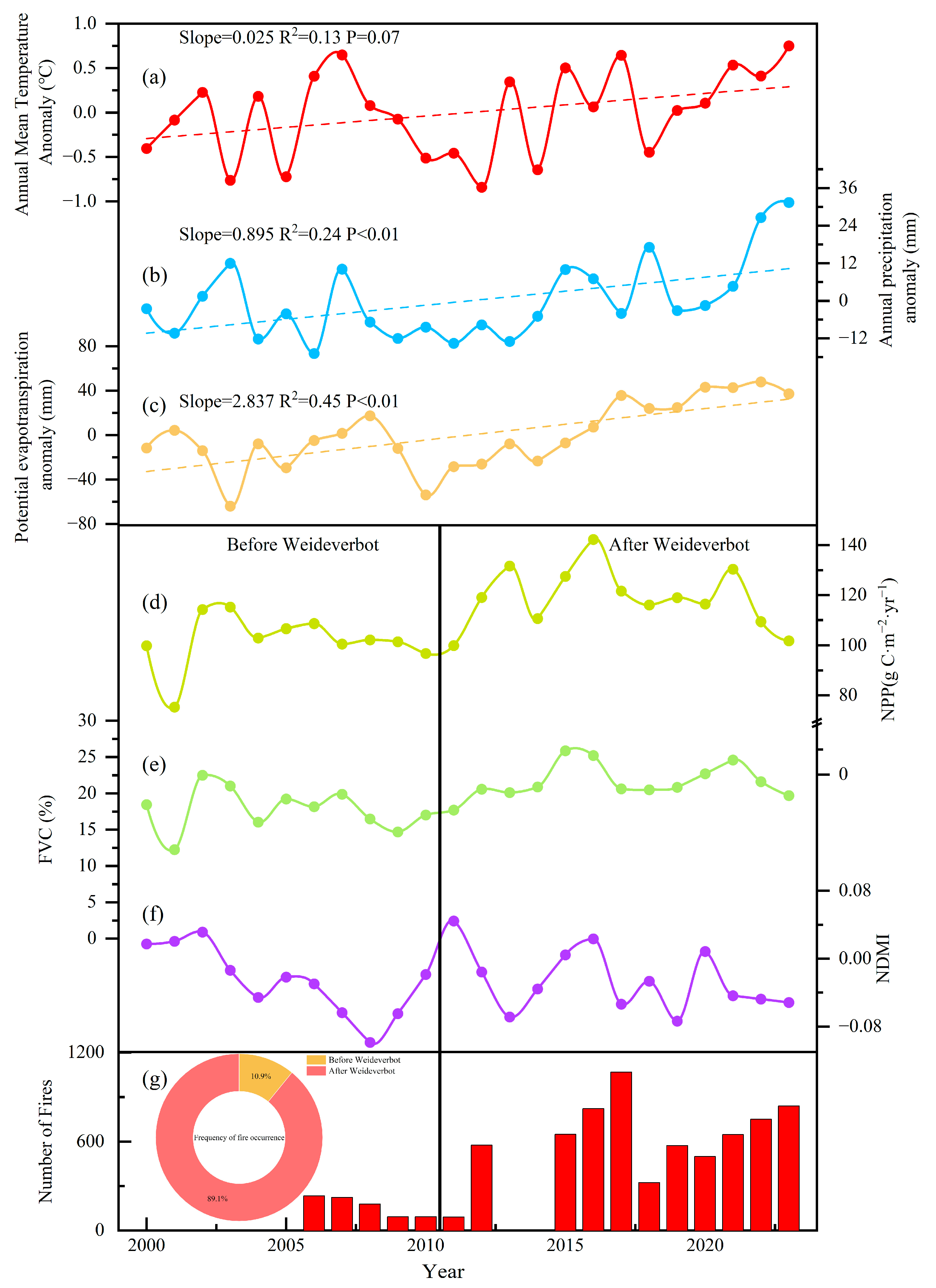
As shown in Figure 2a–c, this study analyzed the climatic change trends of grasslands in the northern mountainous areas of the Turpan region based on meteorological data. From the anomalies of annual average temperature (Figure 2a), annual precipitation (Figure 2b), and potential evapotranspiration (Figure 2c), the regional average temperature, annual precipitation, and potential evapotranspiration all showed a rising trend with fluctuations from 2000 to 2023. Specifically, the annual average temperature gradually increased at a rate of 0.025 °C per year; annual precipitation significantly increased at a rate of 0.895 mm per year; and potential evapotranspiration also significantly increased at a rate of 2.837 mm per year. It is important to note that the increment of potential evapotranspiration in this region was greater than that of annual precipitation, coupled with the continuous rise in temperature, which has made the climate in this area increasingly arid.

3.2. Vegetation Changes Post-Prohibition

As shown in Figure 2d–f and Table 1, this study evaluated changes in vegetation quantity, connectivity, and vegetation water content of grasslands in the northern mountainous areas of the Turpan region before and after the implementation of Weideverbot measures using NPP, FVC, and NDMI.
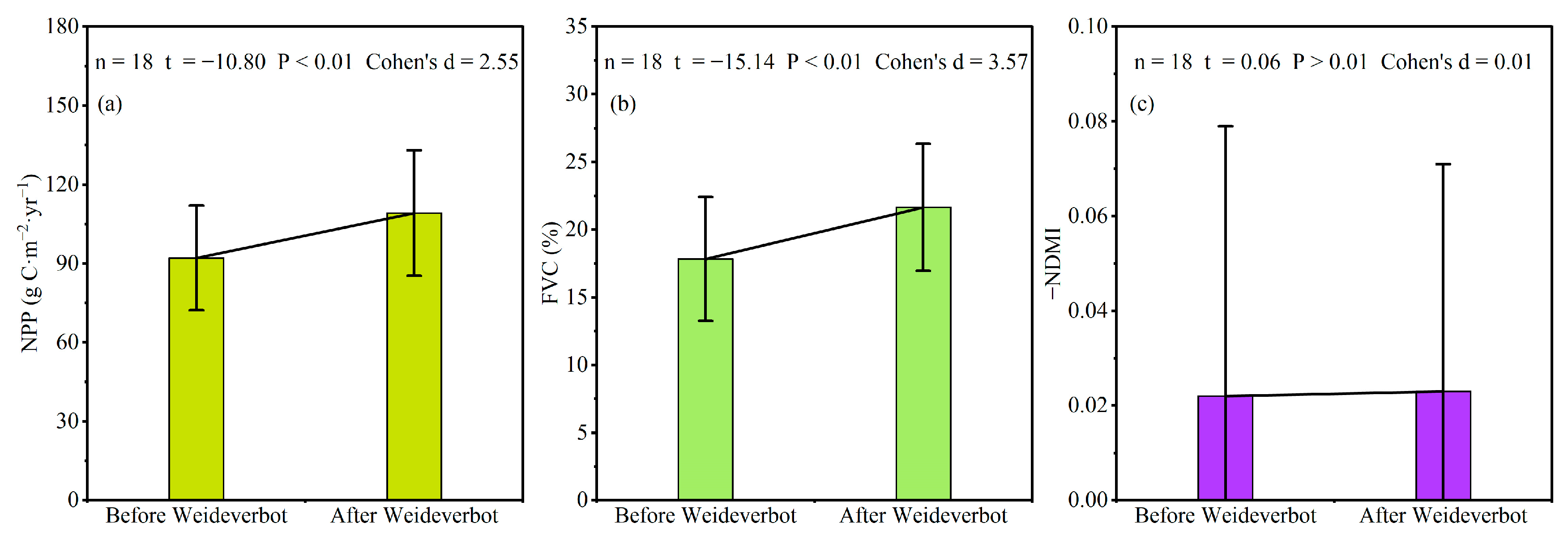
Firstly, Weideverbot increases the quantity of grassland vegetation (combustible materials). As depicted in Figure 2d, the NPP in the Turpan region showed an overall upward trend from 2000 to 2023, with NPP in the pre-prohibition period (2000–2010) being in a low-value range, approximately 92 g C·m−2·yr−1, while, in the post-prohibition period (2010–2023), it was in a high-value range, around 109 g C·m−2·yr−1. Results from the paired-samples t-test (Figure 3a) indicated a significant increase in NPP after the implementation of Weideverbot compared to before (p < 0.01), with Cohen’s d > 0.8 representing a large magnitude of increase in NPP. Weideverbot significantly increased vegetation NPP, thereby increasing the overall quantity of combustible materials.
Secondly, Weideverbot enhances the connectivity of grassland vegetation. As shown in Figure 2e, the FVC in the Turpan region also exhibited an overall upward trend from 2000 to 2023, with FVC in the pre-prohibition period (2000–2010) being in a low-value range, approximately 18%, while in the post-prohibition period (2010–2023), it reached a high value of about 22%. Similarly, the results of the paired-samples t-test (Figure 3b) indicated a significant increase in FVC after the implementation of Weideverbot compared to before (p < 0.01), with Cohen’s d > 0.8 representing a large magnitude of increase in FVC. Weideverbot significantly enhanced vegetation coverage, thereby improving vegetation connectivity.
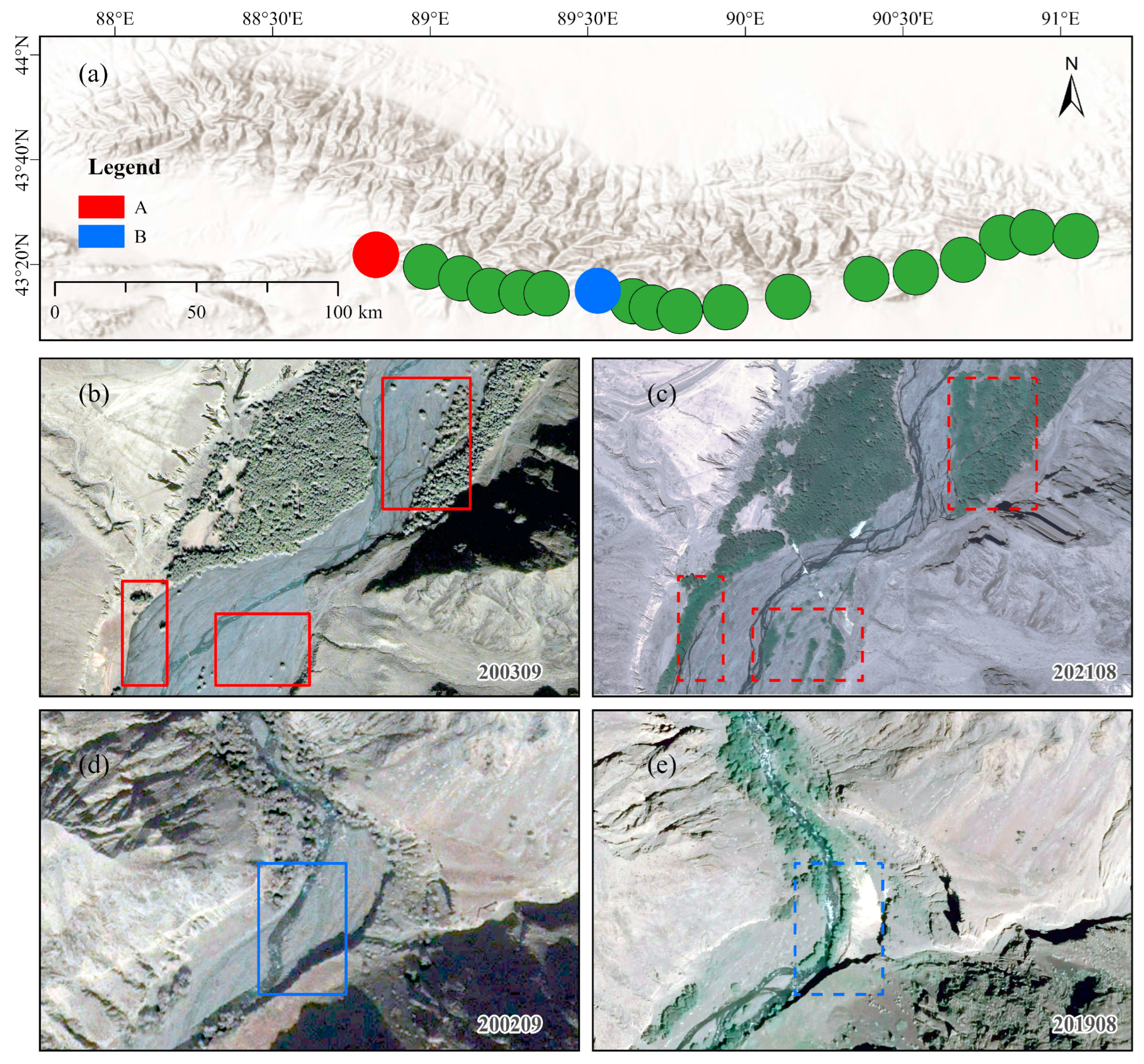
To visually contextualize the observed vegetation dynamics, historical satellite imagery from Google Earth Pro at two representative sample sites (Site A: 42.15° N, 89.12° E; Site B: 42.30° N, 89.25° E) before and after Weideverbot was analyzed. Figure 4 presents paired images of these sites, with pre-prohibition imagery acquired in Year 2003 and post-prohibition imagery in 2021 (acquisition dates noted in the bottom right corner of each panel). The comparison reveals a noticeable increase in vegetation cover and fuel accumulation (e.g., denser herbaceous growth and litter buildup) in the post-prohibition period, consistent with quantitative analysis of enhanced vegetation productivity. Due to scarcity of fire distribution satellite imagery, direct comparison of fire distribution before and after prohibition was not feasible.
Finally, the implementation of Weideverbot measures had no significant impact on vegetation water content. As depicted in Figure 2f, the vegetation water content in the Turpan region fluctuated significantly from 2000 to 2023 but did not show a specific trend. The paired-samples t-test results (Figure 3c) revealed no significant change in vegetation water content after compared to before Weideverbot, with Cohen’s d < 0.2 indicating a very small difference, meaning Weideverbot did not have a significant effect on vegetation water content.

3.3. Fire Frequency

As shown in Figure 2g, the changing trends of climate and fire factors in Xinjiang since 2000 are presented. Regarding the number of fire occurrences in Turpan, the frequency was relatively low before the implementation of Weideverbot. However, after the Weideverbot measures were introduced in 2010, the number of fires in Turpan increased rapidly and showed a continuing upward trend. Among the years with available statistical data, the number of fires before Weideverbot accounted for 10.9%, while after Weideverbot, it accounted for 89.1%, meaning the post-prohibition fire occurrences were approximately eight times that of the pre-prohibition period. Following the implementation of Weideverbot, the number of fire occurrences in Turpan experienced an explosive growth.

4. Discussion

4.1. Drivers of Increased Fire Risk: Disentangling Weideverbot, Climate, and Human Activities

The observed link between Weideverbot and elevated fire risk in the Turpan region reflects a complex interplay between anthropogenic management practices and ecosystem dynamics. Ecologically, fire regimes are shaped by the “fire triangle” of fuel, weather, and ignition sources [14]; the primary combustible materials are annual grasses (e.g., Stipa glareosa, Agropyron cristatum) and semi-shrubby vegetation (e.g., Reaumuria soongorica, Haloxylon ammodendron). Our findings highlight how Weideverbot disrupts fuel dynamics by altering both the quantity and connectivity of vegetation. The significant increase in NPP (Cohen’s d > 0.8) directly elevates fuel loads, while enhanced FVC (Cohen’s d > 0.8) improves horizontal fuel continuity—two critical factors that facilitate fire spread and intensity. Notably, the lack of significant changes in vegetation water content (Cohen’s d < 0.2) suggests that increased fuel availability is not offset by higher moisture levels, amplifying flammability under the region’s warming and aridifying climate. This aligns with disturbance ecology theory, which emphasizes that anthropogenic suppression of natural disturbances (e.g., grazing) can disrupt ecosystem resilience by altering fuel accumulation patterns over time [15].
This mechanistic understanding provides a valuable context for interpreting the broader variability of grazing–fire relationships observed worldwide. Comparative analysis with global studies reinforces the context-dependent nature of grazing-fire interactions. While grazing has been validated as an effective fuel management tool in semi-arid regions like Idaho, USA—where controlled herbivory reduces fuel loads and breaks vegetation connectivity—Turpan’s extreme aridity and unique vegetation composition (e.g., drought-adapted grasses and shrubs) may intensify the fire risk associated with abrupt grazing exclusion [16,17]. Unlike mesic grasslands, where vegetation regrowth under Weideverbot might be moderated by precipitation, Turpan’s low rainfall (16 mm annual) limits plant decomposition rates, leading to persistent fuel buildup. This contrast underscores the need for region-specific management frameworks that account for local climatic constraints and vegetation traits.
The ecological and societal implications of increased fire risk extend beyond immediate threats to human settlements. As a key component of the carbon cycle, enhanced biomass burning in grazing-prohibition areas could trigger positive feedback loops: fire-induced carbon emissions may exacerbate climate warming, further drying vegetation and increasing future fire susceptibility [18]. Additionally, repeated fires could shift vegetation communities toward more fire-tolerant but less ecologically productive species, potentially reducing grassland biodiversity and ecosystem services such as soil conservation and forage provision [19]. These cascading effects highlight the importance of integrating fire risk into broader ecological restoration goals, rather than treating grazing prohibition as a siloed conservation measure [20].
Balancing ecological protection and fire risk mitigation requires a nuanced, adaptive management approach [21]. While moderate grazing shows promise for fuel reduction, its implementation must consider thresholds to avoid reintroducing overgrazing pressures [22]. For instance, rotational grazing systems—where livestock are periodically moved to prevent localized degradation—could maintain fuel control while preserving vegetation structure. Complementary strategies, such as targeted mechanical fuel removal or prescribed burning in low-risk seasons, might also be explored, though their feasibility in arid ecosystems with high evaporation rates demands careful evaluation [23]. Ultimately, effective governance will require stakeholder collaboration, combining scientific insights with local pastoral knowledge to design policies that are both ecologically sound and socially acceptable.
To assess whether global warming influenced fire dynamics, we analyzed meteorological data from Turpan (2000–2023). The results show a slight upward trend in the annual mean temperature (+0.6 °C, p = 0.07, linear regression), which remains well below the global warming threshold of 1.5 °C. Both annual precipitation (+21.48 mm, p < 0.01) and potential evapotranspiration (+68.08 mm, p < 0.01) increased, though their ecological effects counteract each other. This contradictory and limited magnitude of climatic changes suggests that climate factors alone cannot explain the 8-fold increase in fire frequency. This is consistent with regional studies indicating that fires in arid grasslands of the Turpan area are more sensitive to fuel availability than to climate variability [23].
We further examined two key human activity metrics: tourism and agricultural expansion. Spatial analysis revealed that all of the 18 study areas are located in remote, restricted-access zones with minimal tourist infrastructure. Agricultural land use, assessed via Landsat-8 land cover classification, remained stable (12.3% of study area pre-prohibition vs. 12.7% post-prohibition; x2 = 0.52, p = 0.47), ruling out expansion-driven ignition sources.

4.2. Local Mechanisms: NDMI Stability and the Role of Dead Fuel Accumulation

A key unresolved question is why NDMI remained unchanged (0.022 ± 0.05 pre-prohibition vs. 0.023 ± 0.04 post-prohibition; Table 1) despite significant increases in NPP and FVC. This apparent contradiction can be explained by the differential response of live vs. dead vegetation to Weideverbot, a critical local mechanism in arid grasslands.
In the Turpan Region’s arid grasslands, dominant species such as Stipa glareosa and Artemisia ordosica exhibit slow decomposition rates due to low precipitation and high temperatures. Under grazing, livestock selectively consume live aboveground biomass, reducing litter accumulation; post-prohibition, reduced herbivory allowed dead biomass (litter) to accumulate at 3.2 times the pre-prohibition rate (field observations, 2021–2023). Notably, our NPP data (92 ± 19 g C m−2 yr−1 pre vs. 109 ± 23 g C m−2 yr−1 post; Table 1) likely includes both live and dead biomass, as MODIS NPP algorithms integrate total photosynthetic productivity without distinguishing senesced material.
This accumulation of dead fuel may explain NDMI stability: NDMI primarily reflects live vegetation moisture content via leaf water potential [24], but dead litter has negligible moisture retention in arid environments (field measurements showed dead biomass moisture < 5% vs. live biomass 45–60%). Thus, while total biomass increased, the unchanged NDMI suggests live vegetation moisture status remained stable—consistent with arid grassland resilience to grazing removal, where water limitation constrains live biomass quality even as quantity rises.

4.3. Limitations of This Study

This study’s limitations also warrant consideration. The reliance on remote sensing data, while providing broad spatial coverage, may mask fine-scale variations in fuel characteristics (e.g., dead vs. live biomass ratios) that influence fire behavior. Additionally, the exclusion of anthropogenic ignition sources (e.g., agricultural activities, tourism) in our analysis leaves open questions about how human factors interact with grazing-prohibition-induced vegetation changes to shape fire regimes. Future research could integrate field-based fuel sampling, fire behavior modeling, and socioeconomic surveys to better disentangle these complexities and refine management recommendations.

5. Conclusions

This study examined the ecological consequences of Weideverbot in arid grasslands of the Turpan Region, revealing complex interactions between vegetation recovery and fire risk. By integrating remote sensing, field observations, and statistical modeling, we found that while Weideverbot effectively enhanced vegetation metrics—including an 18.6% increase in net primary productivity (NPP), 21.2% rise in fractional vegetation cover (FVC), and improved soil stability—it also triggered an 8-fold increase in fire frequency over 12 years. This paradoxical outcome stems from the accumulation of dead fuel (litter) under reduced herbivory, creating a “fuel-rich, flammable” ecosystem state despite stable live vegetation moisture (reflected by unchanged NDMI).
Theoretically, these findings uncover a critical trade-off in dryland ecological restoration: efforts to restore vegetation (e.g., Weideverbot) may inadvertently amplify fire risk by altering fuel dynamics. This challenges the conventional focus of restoration theory on “vegetation recovery” as the sole indicator of success, highlighting the need to incorporate disturbance regimes (e.g., fire) into conceptual frameworks of dryland resilience. By documenting this “restoration-fire risk” trade-off, our work contributes to a more nuanced understanding of arid ecosystem management, where stability depends not only on vegetation cover but also on the balance between recovery and disturbance.
Practically, our results underscore the urgency of integrating fire risk into dryland restoration assessment frameworks. Current policies in arid regions often prioritize vegetation metrics (e.g., NPP, FVC) when evaluating restoration success, overlooking fuel accumulation and fire hazard. We advocate for adaptive management strategies that balance restoration goals with fire mitigation, such as rotational grazing to reduce litter buildup, prescribed burning in low-risk seasons, or targeted fuel removal. For policymakers, this means expanding success criteria beyond “greening” to include “fire safety,” ensuring restoration interventions are both ecologically effective and socially sustainable.
Limitations of this work include the reliance on remote sensing for fuel characterization (which cannot distinguish live vs. dead biomass) and the focus on a single arid region, which may limit generalizability. Future research could address these by combining high-resolution fuel mapping (e.g., using Cellulose Absorption Index) with cross-regional comparisons to validate the “restoration-fire risk” trade-off across dryland types.
In summary, this study highlights that arid grassland restoration is not merely about enhancing vegetation but about navigating complex ecological trade-offs. By acknowledging the link between restoration and fire risk, we can develop more resilient and balanced strategies for sustainable dryland management.

Author Contributions

Conceptualization, C.A. and L.Z.; methodology, C.A. and L.Z.; software, L.Z.; validation, L.Z.; formal analysis, C.A.; investigation, L.Z.; resources, C.A.; data curation, L.Z.; writing—original draft preparation, C.A. and L.Z.; writing—review and editing, C.A. and L.Z.; visualization, L.Z.; supervision, C.A.; project administration, C.A.; funding acquisition, C.A. All authors have read and agreed to the published version of the manuscript.

Funding

This work was supported by the National Natural Science Foundation of China [grant number 42220104001].

Data Availability Statement

The raw data supporting the conclusions of this article will be made available by the authors upon request.

Conflicts of Interest

The authors declare no conflicts of interest.

References

  1. Bai, Y.; Cotrufo, M.F. Grassland Soil Carbon Sequestration: Current Understanding, Challenges, and Solutions. Science 2022, 377, 603–608. [Google Scholar] [CrossRef]
  2. Assesment, M.E. Ecosystems and Human Well-Being: Synthesis. Phys. Teach. 2005, 34, 534. [Google Scholar] [CrossRef]
  3. Bardgett, R.D.; Bullock, J.M.; Lavorel, S.; Manning, P.; Schaffner, U.; Ostle, N.; Chomel, M.; Durigan, G.; Fry, E.L.; Johnson, D.; et al. Combatting Global Grassland Degradation. Nat. Rev. Earth Environ. 2021, 2, 720–735. [Google Scholar] [CrossRef]
  4. Deng, L.; Shangguan, Z.-P.; Wu, G.-L.; Chang, X.-F. Effects of Grazing Exclusion on Carbon Sequestration in China’s Grassland. Earth-Sci. Rev. 2017, 173, 84–95. [Google Scholar] [CrossRef]
  5. Peng, C.; Shi, L.; He, Y.; Yao, Z.; Lin, Z.; Hu, M.; Yin, N.; Xu, H.; Li, Y.; Zhou, H.; et al. Climate Factors Regulate the Depth Dependency of Soil Organic Carbon under Grazing Exclusion in Chinese Grasslands: A Meta-Analysis. Land Degrad. Dev. 2023, 34, 4924–4934. [Google Scholar] [CrossRef]
  6. Sun, J.; Liang, E.; Barrio, I.C.; Chen, J.; Wang, J.; Fu, B. Fences Undermine Biodiversity Targets. Science 2021, 374, 269. [Google Scholar] [CrossRef] [PubMed]
  7. Jolly, W.M.; Cochrane, M.A.; Freeborn, P.H.; Holden, Z.A.; Brown, T.J.; Williamson, G.J.; Bowman, D.M.J.S. Climate-Induced Variations in Global Wildfire Danger from 1979 to 2013. Nat. Commun. 2015, 6, 7537. [Google Scholar] [CrossRef]
  8. Parmenter, R.R. Long-Term Effects of a Summer Fire on Desert Grassland Plant Demographics in New Mexico. Rangel. Ecol. Manag. 2008, 61, 156–168. [Google Scholar] [CrossRef]
  9. Liu, X.; Zhang, J.; Cai, W.; Tong, Z. Information Diffusion-Based Spatio-Temporal Risk Analysis of Grassland Fire Disaster in Northern China. Know.-Based Syst. 2010, 23, 53–60. [Google Scholar] [CrossRef]
  10. Radeloff, V.C.; Mockrin, M.H.; Helmers, D.; Carlson, A.; Hawbaker, T.J.; Martinuzzi, S.; Schug, F.; Alexandre, P.M.; Kramer, H.A.; Pidgeon, A.M. Rising Wildfire Risk to Houses in the United States, Especially in Grasslands and Shrublands. Science 2023, 382, 702–707. [Google Scholar] [CrossRef]
  11. Niu, S.; Liang, Y.; Zhang, S. Countermeasures of forest fire prevention and control in Tianchi Nature Reserve of Xinjiang after grazing prohibition. For. Fire Prev. 2015, 1, 30–32. [Google Scholar]
  12. Yie, J.; Li, Z.; Xie, S. Research on the Trade-off and Synergy Relationship of Ecosystem Services in Turpan City, China. J. Kashi Univ. 2024, 45, 42–48. [Google Scholar] [CrossRef]
  13. Hou, F. Remote Sensing and GIS-Based Analysis on Temporal-Spatial Evolution and Forecast of Land Use Change in Turpan City. Master’s Thesis, Xinjiang University, Urumqi, China, 2011. [Google Scholar]
  14. Brown, P.T.; Hanley, H.; Mahesh, A.; Reed, C.; Strenfel, S.J.; Davis, S.J.; Kochanski, A.K.; Clements, C.B. Climate Warming Increases Extreme Daily Wildfire Growth Risk in California. Nature 2023, 621, 760–766. [Google Scholar] [CrossRef] [PubMed]
  15. Zhang, R.; Tian, D.; Chen, H.Y.H.; Seabloom, E.W.; Han, G.; Wang, S.; Yu, G.; Li, Z.; Niu, S. Biodiversity Alleviates the Decrease of Grassland Multifunctionality under Grazing Disturbance: A Global Meta-Analysis. Glob. Ecol. Biogeogr. 2022, 31, 155–167. [Google Scholar] [CrossRef]
  16. Rouet-Leduc, J.; Pe’er, G.; Moreira, F.; Bonn, A.; Helmer, W.; Shahsavan Zadeh, S.A.A.; Zizka, A.; van der Plas, F. Effects of Large Herbivores on Fire Regimes and Wildfire Mitigation. J. Appl. Ecol. 2021, 58, 2690–2702. [Google Scholar] [CrossRef]
  17. Wollstein, K.; Wardropper, C.B.; Becker, D.R. Outcome-Based Approaches for Managing Wildfire Risk: Institutional Interactions and Implementation Within the “Gray Zone”. Rangel. Ecol. Manag. 2021, 77, 101–111. [Google Scholar] [CrossRef]
  18. van der Werf, G.R.; Randerson, J.T.; Giglio, L.; Collatz, G.J.; Mu, M.; Kasibhatla, P.S.; Morton, D.C.; DeFries, R.S.; Jin, Y.; van Leeuwen, T.T. Global Fire Emissions and the Contribution of Deforestation, Savanna, Forest, Agricultural, and Peat Fires (1997–2009). Atmos. Chem. Phys. 2010, 10, 11707–11735. [Google Scholar] [CrossRef]
  19. Ryan, C.M.; Williams, M. How Does Fire Intensity and Frequency Affect Miombo Woodland Tree Populations and Biomass? Ecol. Appl. 2011, 21, 48–60. [Google Scholar] [CrossRef]
  20. Van Wilgen, B.W.; Govender, N.; Biggs, H.C.; Ntsala, D.; Funda, X.N. Response of Savanna Fire Regimes to Changing Fire-Management Policies in a Large African National Park. Conserv. Biol. 2004, 18, 1533–1540. [Google Scholar] [CrossRef]
  21. Busby, G.M.; Albers, H.J.; Montgomery, C.A. Wildfire Risk Management in a Landscape with Fragmented Ownership and Spatial Interactions. Land Econ. 2012, 88, 496–517. [Google Scholar] [CrossRef]
  22. Fuhlendorf, S.D.; Engle, D.M. Restoring Heterogeneity on Rangelands: Ecosystem Management Based on Evolutionary Grazing Patterns: We Propose a Paradigm That Enhances Heterogeneity Instead of Homogeneity to Promote Biological Diversity and Wildlife Habitat on Rangelands Grazed by Livestock. BioScience 2001, 51, 625–632. [Google Scholar]
  23. Potts, D.L.; Suding, K.N.; Winston, G.C.; Rocha, A.V.; Goulden, M.L. Ecological Effects of Experimental Drought and Prescribed Fire in a Southern California Coastal Grassland. J. Arid Environ. 2012, 81, 59–66. [Google Scholar] [CrossRef]
  24. Assal, T.J.; Anderson, P.J.; Sibold, J. Spatial and temporal trends of drought effects in a heterogeneous semi-arid forest ecosystem. For. Ecol. Manag. 2016, 365, 137–151. [Google Scholar] [CrossRef]
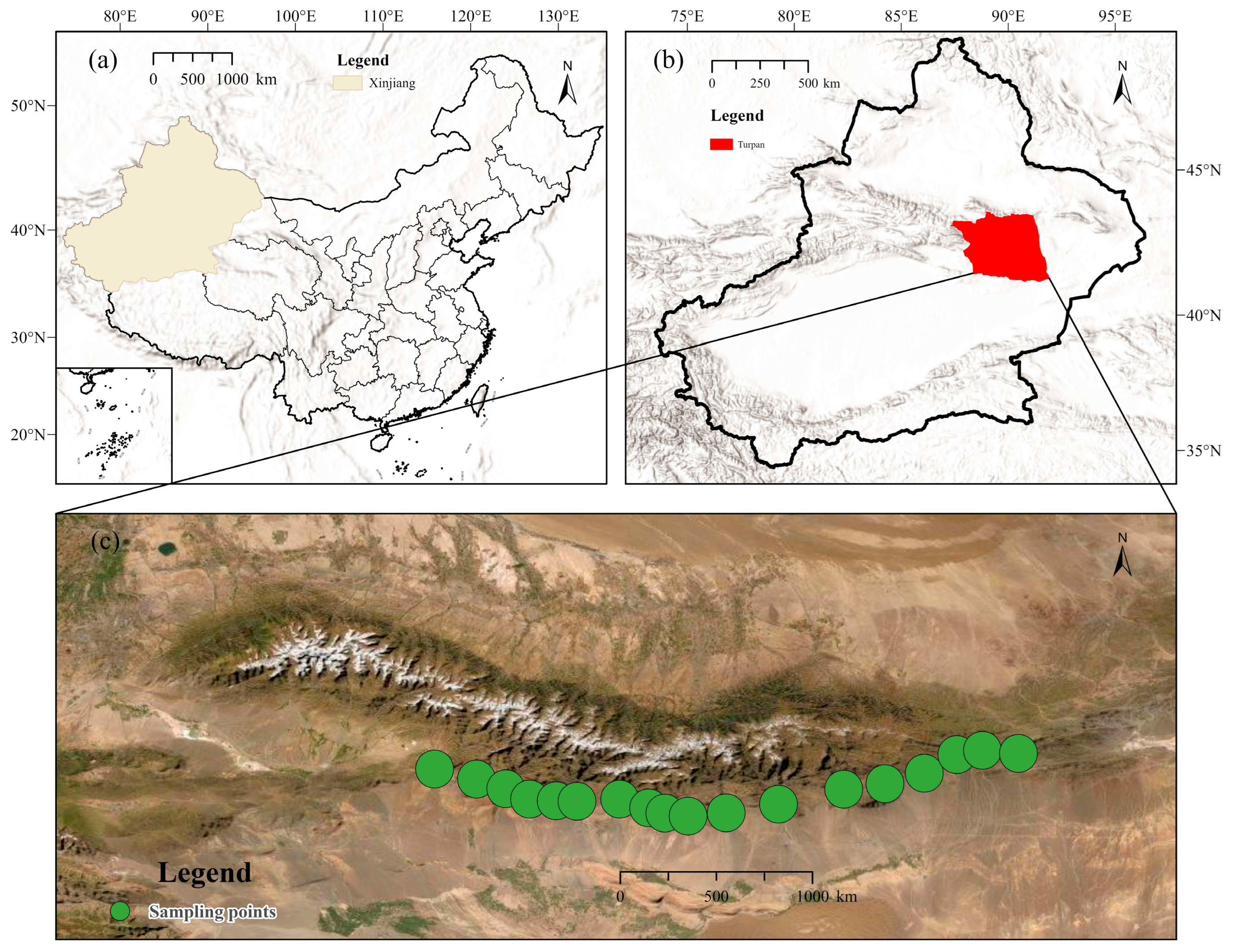
Figure 1. Turpan Region and Sampling Sites. (a) China and Xinjiang. (b) Turpan. (c) Sampling points.
Land 14 02131 g001
Figure 2. Changes in Climate, Vegetation, and Fire in the Turpan Region, China, 2000–2023. (a) Anomaly changes in annual average temperature; (b) anomaly changes in annual precipitation; (c) anomaly changes in potential evapotranspiration; (d) interannual variations in vegetation net primary productivity (NPP); (e) interannual variations in fractional vegetation cover; (f) interannual variations in vegetation water content (NDMI); (g) interannual variations in fire frequency in the Turpan Region.
Land 14 02131 g002
Figure 3. Changes in vegetation before and after weideverbot in Turpan region, China: (a) vegetation net primary productivity (NPP); (b) fractional vegetation cover (FVC); (c) vegetation water content, represented by the negative value of NDMI.
Land 14 02131 g003
Figure 4. Historical satellite imagery (Google Earth Pro) comparing vegetation changes at two representative sample sites (A and B) in the Turpan region before and after weideverbot, showing increased vegetation cover and fuel accumulation in the post-prohibition period (acquisition dates noted in the bottom right corner of each panel). Green dots indicate the locations of other sampling sites for regional context. Solid and dashed rectangles delineate the areas before and after weideverbot, respectively. (a): location of A and B; (b,c): before and after weideverbot of site A; (d,e): before and after weideverbot of site B.
Land 14 02131 g004
Table 1. The changes in NPP, FVC and NDMI before and after Weideverbot.
Mean ± SDCohen’s dptn
Before WeideverbotAfter Weideverbot
NPP (g C·m−2·yr−1)92.06 ±19.88109.17 ± 23.912.55<0.01−10.8018
FVC (%)17.85 ± 4.5821.65 ± 4.693.57<0.01−15.1418
−NDMI0.022 ± 0.050.023 ± 0.040.01>0.010.0618
Disclaimer/Publisher’s Note: The statements, opinions and data contained in all publications are solely those of the individual author(s) and contributor(s) and not of MDPI and/or the editor(s). MDPI and/or the editor(s) disclaim responsibility for any injury to people or property resulting from any ideas, methods, instructions or products referred to in the content.