Article

The Living Palimpsest Profile: An Integrated Assessment Framework for Vernacular Rural Settlements

1
Department for Architecture, Faculty of Technical Sciences, University of Priština in Kosovska Mitrovica, 38220 Kosovska Mitrovica, Serbia
2
Department of Civil Engineering, School of Engineering, University of West Attica, 12241 Egaleo, Attica, Greece
3
Department for Civil Engineering, Faculty of Technical Sciences, University of Priština in Kosovska Mitrovica, 38220 Kosovska Mitrovica, Serbia
4
Department of Surveying and Geoinformatics Engineering, School of Engineering, University of West Attica, 12241 Egaleo, Attica, Greece
*
Author to whom correspondence should be addressed.
Land 2025, 14(11), 2130; https://doi.org/10.3390/land14112130 (registering DOI)
Submission received: 29 September 2025 / Revised: 23 October 2025 / Accepted: 24 October 2025 / Published: 26 October 2025
(This article belongs to the Special Issue Emerging Technologies Towards Sustainable Urban Transitions)

Abstract

Rural areas across Europe, particularly in the Balkans, are confronting a challenging and uneven negative transformation, marked by depopulation, economic stagnation and the degradation of their vernacular heritage. Assessing the unique dynamics and historical reality of these settlements proves difficult because conventional sustainability assessment systems are typically urban-focused and static. To address the methodological shortfall, this research introduces the Living Palimpsest Profile (LPP), a novel framework that conceptualizes rural settlements as layered landscapes in which time is treated as an endogenous variable in the sustainability equation. Employing the palimpsest metaphor, the LPP integrates a rigorous qualitative assessment, validated through convergent verification, with a hierarchical Framework of Visions. The framework was applied successfully to two Balkan case studies, demonstrating capacity to capture local specificity and inform contextual policy segmentation in line with the Sustainable Development Goals (SDGs). Given its significant transferability to other heritage-rich regions, the LPP is positioned as an essential methodological solution for the sustainable development of vernacular settlements worldwide.

1. Introduction

The 21st century has brought transformative changes to rural areas across Europe and globally. These changes present a mixed picture, with benefits such as enhanced connectivity to urban centers and increased capital inflow, counterbalanced by drawbacks, especially in disadvantaged and remote regions [1,2]. Critically, the process of rural transformation is highly non-uniform, with its scale and nature varying significantly from one region to another [3].
In the Balkans, the dominant narrative is one of negative rural transformations. Balkans rural settlements currently confront a myriad of challenges, including depopulation and shifts in population structure, adverse economic conditions, deagrarization, agricultural land fragmentation, environmental degradation, high unemployment rates, outdated infrastructure and a pervasive lack of development [4,5,6]. The decline persists despite referent national legislation, e.g., [4,7], and various development and support programs, e.g., [8]. Rural decline in the Balkans not only blocks the potential of abundant vernacular values [9,10,11] to serve as guardians of cultural identity and diversity, but the degradation of these settlements also leads to the loss of communities, the erosion of a vast, often undocumented, repository of vernacular values, and to severing of ties [12] between spatial, social, cultural and economic components.
Despite the ongoing rural crisis, regulations, strategies and plans for vernacular rural settlements in the Balkans are often unsuitable, inconsistently implemented or not prioritized. Consequently, sustainability assessment of these settlements cannot be based on evaluating policies, plans or zoning regulations, which is a practice elsewhere, e.g., [13]. Furthermore, though alternative options for evaluating rural sustainability have been explored [14], such as Ciampa et al.’s approach [15], these methodologies fail to account for the cumulative, layered process of historical transformation over time.
Beyond the necessity for studying cumulative history, the assessment of vernacular rural settlements inevitably must be grounded in localized sustainability. A broader shift toward localized planning was significantly influenced by Agenda 21 and its subsequent articulation in Local Agenda 21 [16], which laid the groundwork for community-led strategies tailored to specific local contexts. Such an approach aligns closely with the Sustainable Development Goals (SDGs).
Therefore, any effective assessment framework for rural settlements should align with the SDGs and integrate all aspects of sustainability while explicitly accounting for the valuable vernacular component. Given the current state of Balkans settlements, the primary purpose of the assessment is to yield results that allow for actionable improvements.
A major limitation of most available sustainability assessment indicators, tools and frameworks is that they are urban-focused and provide a static profile for only a single point in time, preventing the registration of time-related trends. As Cavalieri and Cogato Lanza argue, a territory undergoes continuous environmental, social and economic transitions [17], and existing models are ill-equipped to track these (accelerating) changes in vernacular rural settlements.

The Living Palimpsest Profile (LPP): An Innovative Assessment and Action Framework

The theoretical foundation for overcoming the limitations of static models lies in the palimpsest metaphor, a concept first introduced by Thomas De Quincey and later applied to spatial studies by André Corboz. This perspective offers a four-dimensional, contextual view that portrays space through its chronological evolution, allowing for a unified apprehension of space and time [17,18]. The metaphor enables different historical and conceptual layers to coexist without merging [19,20], thereby leaving room “for what is or was in the landscape” [19] (p. 69). The palimpsest acts as a tool that “forces entanglement and consideration of various aspects of historical, current and future impacts on the environment” [19] (p. 63). It incorporates “flow, temporalities and multiple narratives into a time seen as a fluid duration, not as a system of sequential measurement” [19] (p. 65). Fluid approach allows for a holistic consideration of “the varied cultural and environmental constructions of landscape” without prioritizing one over another [19] (p. 70), making the palimpsest metaphor an invaluable asset for architectural, urban and cultural studies, as well as for design and planning [17].
Despite the significant potential, the palimpsest concept has rarely been applied to contemporary rural studies. While research has used the analogy to explore interactions between tradition and modernity in rural-to-urban transitions [21], document layered marks of historical agricultural use [22], or analyze cultural contexts like the Korean rural landscape in film [23], no study has yet integrated sustainability and the palimpsest into a single assessment framework for vernacular rural settlements.
By embracing a palimpsest perspective, sustainability is recast as an everlasting process that safeguards memory while enabling a settlement’s contemporary relevance and innovation. Instead of freezing a found state in time, the integrated approach encourages an assessment that allows vernacular settlements not only to be preserved but also to remain meaningful in an ever-changing society. It is within this theoretical framework that the shortcomings of existing assessment models become most apparent, underscoring the need for the new, inclusive methodology proposed here.
The overall objective of this research is to develop and validate a novel, context-sensitive assessment framework—the Living Palimpsest Profile (LPP)—that integrates layered transformations into a dual-indicator system, thereby enabling to formulate differentiated, robust and globally aligned action plans for the sustainable revitalization of vernacular rural settlements. The term “Living Palimpsest Profile” was coined by the authors to simultaneously depict the intended dynamic and multi-layered character of the assessment, the comprehensive contents, the final outcome and the actionable utilization.
Thus, the LPP is designed as a cohesive tool that provides a comprehensive overview of a settlement’s values and its environmental, social and economic sustainability traits, while also offering clear guidelines for improvement and further development. It begins with an assessment based on established qualitative indicators and the production of Living Palimpsest Report, and concludes with a Framework of Visions—a series of concrete proposed actions and project ideas. The dual approach, which combines rigorous assessment with actionable planning, represents a distinct innovation and gives the LPP broad applicability.
The research aims to answer the following questions regarding the LPP framework:
  • How can the palimpsest metaphor be integrated into a sustainability assessment framework to effectively overcome the limitations of static, urban-focused existing models and provide a rigorous, comprehensive diagnosis for vernacular rural settlements?
  • Does the LPP methodology possess sufficient contextual sensitivity and robustness to generate distinct and tailored Frameworks of Visions that align with both the specific Sustainable Development Goals (SDGs) and priorities demanded by different local challenges and positive attributes?
The manuscript follows a structured methodological progression designed to develop and validate the proposed LPP framework.
Critical review and development (Section 2 and Section 3) establish the need for a new methodology by critically reviewing existing assessment frameworks and proposing the LPP, which integrates the palimpsest metaphor into a dual-indicator system.
Application and analytic diagnosis (Section 4.1, Section 4.2 and Section 4.3) validate the LPP’s efficacy by conducting a mixed-method assessment, utilizing data synthesis and consensus verification on two distinct Balkan case studies (Korogonianika and Velika Hoča), yielding two comprehensive Living Palimpsest Reports and an analytic interpretation of layered interactions.
Synthesis, visioning and comparison (Section 4.4) translate the contextual findings of the obtained reports into actionable planning by formulating two distinct, comparable hierarchical Frameworks of Visions, ensuring alignment with global and European policy mandates.
Consideration of limitations, transferability and digital operationalization (Section 4.5) concludes the research by demonstrating the LPP’s sensitivity and robustness, and discussing its transferability, limitations and future digital operationalization.
The LPP, through the palimpsest metaphor, challenges static sustainability theory where ‘time’ is often treated as an exogenous factor (a target date to be reached or a rigid condition to be maintained). Instead, the LPP makes time and history endogenous variables. Sustainability is defined by the successful management of cumulative, layered change; the LPP forces the simultaneous assessment of what was (past layers), what is (present layers), and what will be (future action). This structural integration ensures that historical patterns of adaptation and conflict are actively factored into the current diagnostic, fundamentally redefining the sustainability equation for vernacular settlements.

2. A Critical Review of Existing Sustainability Assessment Frameworks

2.1. Sustainability Indicators

Using measurable values as sustainability indicators is a useful way to track progress toward sustainable development goals and is valuable for comparative studies assessing specific clusters of sustainability quality across different environments [24,25]. However, many widely used indicators sets, whether general frameworks [26,27], or rural-specific tools [28,29], are fundamentally transactional and focused on specific points in time. The exclusion of the palimpsest component from these frameworks represents a significant constraint. The omission can lead not only to misleading assessment results but also to the implementation of maladaptive and counterproductive strategies for rural settlements.
While indicator frameworks focus on the current state and short-term trends, the palimpsest concept acknowledges the layered history and space-time transformations that truly shape rural settlements and their communities. By neglecting the palimpsest, standardized indicators reduce complex environments to isolated data points, inherently failing to evaluate cumulative impacts or capture specific social and cultural components, thereby risking maladaptive solutions. Conversely, including the palimpsest concept makes it possible to effectively understand the complex causes behind current challenges and determine what is truly needed for genuine and lasting sustainability in a specific vernacular rural settlement.

2.2. Sustainability Rating Tools (SRTs)

Sustainability Rating Tools (SRTs) have become important instruments in assessing the environmental, economic and social performance of places and communities. Though originally developed for individual buildings, they have evolved to cover broader spatial scales, including neighborhoods/communities and entire urban areas [30]. However, even the latest versions of prominent SRTs remain fundamentally urban-oriented [31].
SRTs are primarily designed for developments in the planning or construction stages, or those recently completed [32,33]. With the exception of BREEAM Communities, which includes regeneration projects, these tools are not specifically designed for assessing the existing built environment, let alone the nuances of rural areas. Consequently, the SRTs fail to adequately address the unique attributes of non-urban or traditional contexts [34].
Critiques highlight that some SRTs disproportionately emphasize environmental factors while marginalizing social and cultural dimensions [35]. One study on LEED for Neighborhood Development (LEED-ND), for example, revealed its insufficient engagement with social sustainability concerns [36].
The effectiveness of SRTs varies when applied to culturally and historically significant contexts like vernacular settlements. BREEAM Communities [32] addresses local vernacular to ensure new developments respect local character. It also includes criteria for land reuse, community engagement, and various ecological, social and economic impacts on the existing community. In contrast, LEED-ND [33] focuses primarily on the development itself. While it encourages inclusive design, community participation and preservation of existing resources, and offers optional alignment with geographically specific environmental, social equity and public health priorities, the tool has been criticized for failing to account for many local specificities. A study found that another tool, the Deutsche Gesellschaft für Nachhaltiges Bauen for Urban Districts (DGNB-UD), offers a more comprehensive evaluation compared to LEED-ND [34].
The static nature of SRTs limits their ability to account for the dynamic, evolving qualities of the built environment [37]. They fundamentally exclude the concept of a place as a layered manuscript, ignoring the central role of historical depth and traditional community practices in sustainability. Furthermore, the lack of post-occupancy evaluations limits the ability of SRTs to measure long-term sustainability impacts or adapt to changing community needs. Foundational urban theorists like Lynch [38] and Jacobs [39] have long emphasized the importance of qualitative dimensions, yet these elements are frequently overlooked in official rating frameworks, leading to an incomplete representation of a neighborhood.
Findings underscore the need for more adaptable, context-sensitive assessment approaches, particularly for heritage-rich or socially complex environments. From this perspective, cultural sustainability becomes essential for preserving and advancing cultural heritage, values, traditions and identities across generations [40]. It emphasizes the revitalization of cultural diversity, traditional knowledge and local practices while accommodating adaptation and change [41]. The palimpsest metaphor offers a compelling lens through which to view this process [42,43], conceptualizing culture as a dynamic, evolving narrative where historical continuity and contemporary innovation coexist.

2.3. Qualitative Frameworks

Qualitative frameworks developed over the past decade have marked a significant shift in how different components of the built environment are valued. New platforms have reframed the approach to sustainability, placing greater emphasis on the historical, cultural and social values of places. This has simultaneously led to a shift in focus from quantitative to qualitative assessment, and concurrently, rural settlements have been given greater prominence. The most prominent of these contemporary frameworks is the New European Bauhaus (NEB) [44].
The NEB focuses on solutions for the built environment that are sustainable, inclusive and visually attractive, while respecting the diversity of local cultures and regions. It follows a community-based approach, aiming to provide tailor-made solutions that incorporate diverse and participatory perspectives [15,45]. The connection between the NEB and the palimpsest metaphor is established through valuing the existing, honoring layers of history, and embracing change and continuity.
The evolution of the NEB can be traced through a clear progression of phases, moving from its conceptualization as a high-level idea to its status as a concrete, actionable initiative with dedicated funding and projects. By 2023, the first practical reference tool, the NEB Compass, has been released [46]. The Compass is built on existing frameworks, such as the Davos Baukultur Quality System developed in 2021 [47].
The Davos Baukultur Quality System evaluates places, from individual buildings to entire cultural landscapes, across following categories: Governance, Functionality, Environment, Economy, Diversity, Context, Sense of Place, and Beauty. A key feature of the system is its emphasis on placing social, cultural and emotional values on equal footing with technical and economic considerations [48]. The evaluation centers on a flexible questionnaire with qualitative criteria grouped into the aforementioned categories [49]. The framework is adaptable enough to support different contexts, scales and stages of assessment, including existing conditions, completed projects and planned interventions.
Users of the questionnaire provide textual answers for each criterion, which allows for the descriptive identification of a place’s strengths and weaknesses. The criteria list can be adapted to specific contexts, enabling the addition of place-specific questions. The goal is to foster a deeper understanding of a place’s qualities and to use that knowledge to inform communication, decision-making and future development, rather than simply producing a final score. For a more objective assessment, indicators and benchmarks can be defined for each criterion, tailored to the scale and type of place being evaluated.
The New European Bauhaus (NEB) Compass, introduced in the First NEB Progress Report [50], serves as a foundational reference tool for NEB projects. It was created as an evolving framework to guide decision- and project-makers aiming to apply NEB principles [51]. The Compass is structured around three core values: Beautiful, Sustainable, and Together, and three working principles: Participatory Process, Multi-level Engagement, and a Transdisciplinary Approach. For each of these elements, the Compass provides three levels of ambition to inspire and guide project design from its earliest stages.
While the Compass is primarily intended to guide future projects, its framework can also be adapted to perform a qualitative assessment of the existing built environment. By reframing the guiding questions, the Compass can become a diagnostic tool for understanding a place’s strengths and weaknesses through the NEB’s values. The goal is to create a rich, qualitative narrative about the “now” state, while the levels of ambition can be transformed into guidelines for future action.
The Compass has further evolved into a NEB Self-Assessment Method [52]. This method provides a more detailed, multidisciplinary and quantitative approach to assess projects and their alignment with the NEB values. Unlike the qualitative Compass, the Self-Assessment Method offers a structured way for project developers to score their work against defined criteria. It is intended to facilitate self-improvement and ensure projects meet a certain standard. Therefore, the NEB Self-Assessment Method functions as a specific type of SRT for projects within the New European Bauhaus framework, and the palimpsest component is integrated into it.

3. Materials and Methods

3.1. Development of the Living Palimpsest Profile (LPP) Assessment Model

This research aims to establish an appropriate assessment methodology that can be applied to vernacular rural settlements in the Balkans, which are currently facing various pressures and challenges causing their decline. A thematic content analysis was applied to identify recurring patterns of institutional neglect, fragmented heritage protection, the erosion of cultural identity, and a fundamental misalignment between standardized sustainability indicators, rating tools and frameworks, and local socio-spatial realities.
The research conducted a comprehensive, comparative review of contemporary sustainability assessment models (indicators, tools, and frameworks) to analyze their suitability for vernacular rural settlements. This analysis was guided by three primary criteria: (1) ability to assess all aspects of sustainability; (2) relevance to rural contexts, including cultural sensitivity, contextual adaptability and community participation; and (3) capacity to record spatial-temporal transformations, aligned with the palimpsest concept.
The research combines descriptive, interpretive and critical analysis grounded in cultural sustainability theory and the palimpsest metaphor. By integrating the methodological notion of the palimpsest into the assessment system, an opportunity is created to identify various types of spatial transformations over time. This ranges from simply distinguishing what has been added, transformed, or erased, to analyzing more complex, hybrid processes that intertwine multiple dimensions [17]. Accordingly, the scope of the palimpsest can be adjusted to the specific context being examined, which is precisely the approach taken in this research.
The review of existing models (detailed in Section 2) revealed significant differences in their approaches and outcomes. It was concluded that the optimal assessment framework for vernacular rural settlements must be flexible enough to capture the context-specific characteristics, comprehensive enough to cover all aspects of sustainability and deep enough to trace their palimpsest. The NEB framework and its predecessor, the Davos Baukultur Quality System, were found to be the closest to this benchmark. Given the unique character of vernacular settlements, a qualitative assessment system is deemed superior to one based on quantified indicators.
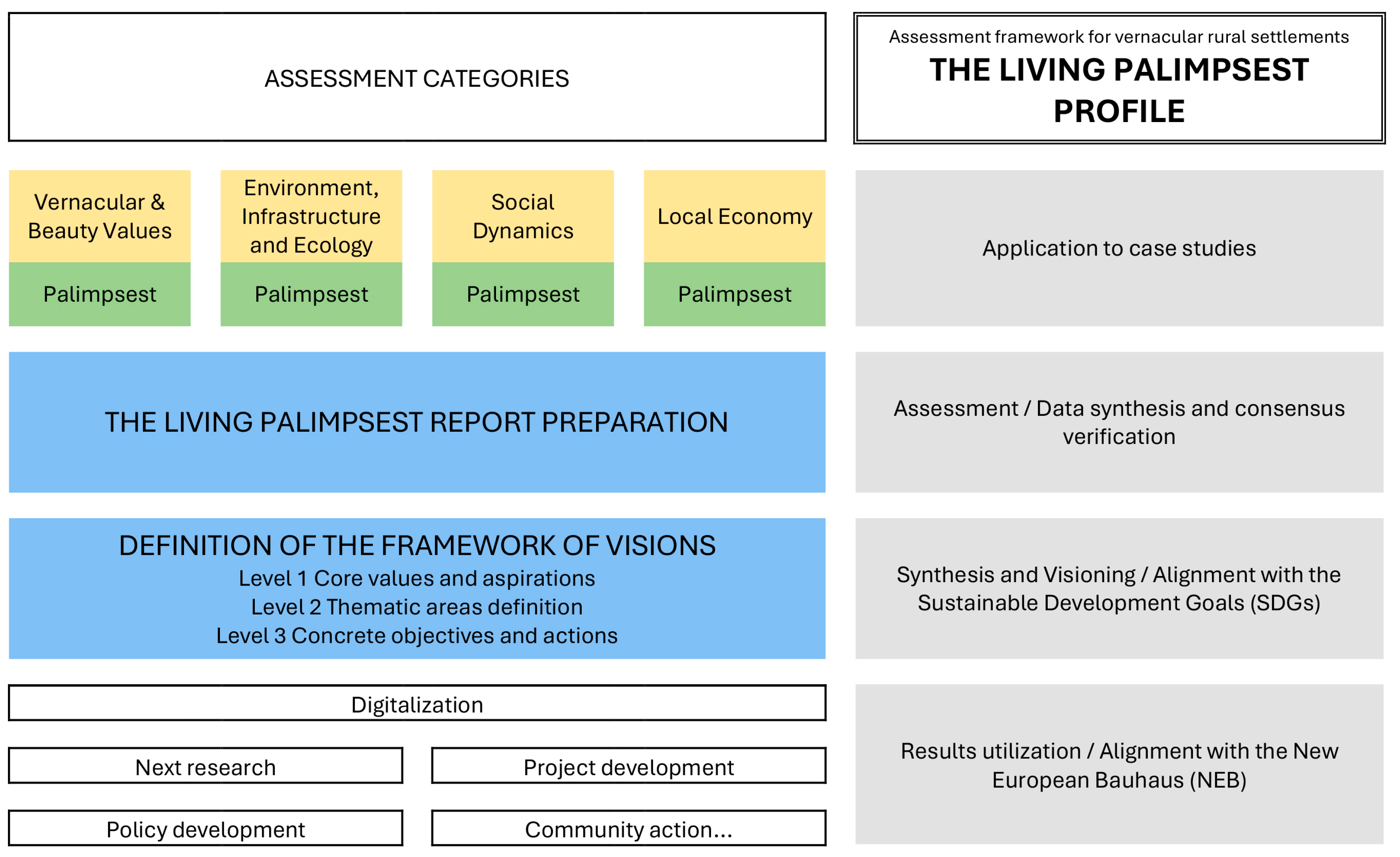
As a result, the innovative sustainability assessment framework for vernacular rural settlements, the Living Palimpsest Profile (LPP), is proposed (Figure 1).
The model’s structure consists of two main parts. The first part is a set of qualitative indicators presented as questions, grouped into four main categories that correspond to the sustainability aspects and vernacular character of rural settlements: Vernacular & Beauty Values; Environment, Infrastructure and Ecology; Social Dynamics; and Local Economy. Presenting qualitative indicators as questions is considered an adequate option for insufficiently studied vernacular rural settlements. This approach sheds light on a deeper understanding of the processes and conditions, and provides a clear path for conducting the assessment and documenting the results. Qualitative indicators focus on understanding the values, perceptions, beliefs and human experiences related to a community’s environmental, social and economic well-being, providing a context and nuance that quantitative data might miss.
In terms of precision, the defined indicators can be described as medium precision. They are sensitive enough to identify important contextual issues yet flexible enough to be applied across the diverse Balkan region. While the region shares many common historical and vernacular characteristics, it is also marked by significant differences in sustainable development policies, and embedded flexibility allows the framework to adapt to those variations.
Within each category, questions are organized on a dual basis: the first set examines a specific sustainability aspect, while the second applies the palimpsest metaphor to that aspect.
Initially, the indicators related to the sustainability aspects were derived through a rigorous methodological synthesis founded on three core pillars: Theoretical grounding (integrating widely recognized sustainability principles, SDGs and NEB postulates); Benchmark models (drawing from the qualitative, comprehensive Davos Baukultur Quality System and the NEB Compass, which address cultural and social dimensions often marginalized by traditional metrics); and Contextual adaptation (empirical fine-tuning the indicators to the specific context of the Balkans to ensure all relevant issues are subjected to assessment, as well as that the limitations imposed by existing policies and plans are overcome). This resultant hybrid model, which combines universal and context-specific indicators, makes it possible to address the most pressing local sustainability issues while still adhering to universally recognized principles.
The questions that apply the palimpsest metaphor were derived separately by the authors via team consensus verification, with the primary purpose of revealing the palimpsest’s twin to sustainability-related questions.
Applying the sets of proposed sustainability- and palimpsest-related indicators involves finding answers to questions relevant both universally and locally. In other research areas, these sets can be supplemented with other context-relevant questions, demonstrating the flexibility embedded within the content of the assessment categories.
In summary, the first part of the LPP can be understood as a qualitative questionnaire (Table 1, Table 2, Table 3 and Table 4) that requires descriptive and well-structured answers, which are then presented in the form of the Living Palimpsest Report.
Notably, the LPP categories and their sustainability-related indicators are aligned with the Sustainable Development Goals (SDGs), with their primary foundation rooted in SDG 11: Make humans settlements inclusive, safe, resilient and sustainable. However, it is the responses to both groups of questions (sustainability-related and palimpsest-related) that establish the context-specific link to the SDGs and their targets. This link is formalized through the establishment of the Framework of Visions, the second part of the LPP.
The Framework of Visions, as named by the authors, is created by reflecting on the assessment results and translating them into a structured, three-level system that allows for both inspirational, long-term thinking and practical, short-term action, with a clear bridge between the two. These visions inherently support the achievement of the SDGs and their sub-goals (targets). However, in the absence of clearly formulated priorities communicated by adopted national, regional or local policies and plans (as is often the case in Balkan rural settlements), the decision regarding which specific SDGs will be addressed is contingent upon the specific findings within the LPP report for each settlement. This adaptability is necessary because Balkan rural settlements exhibit a very wide diversity in terms of development level and key challenges. Limiting the framework to only certain predefined SDGs might render the model ineffective in specific local environments. In contrast, by ensuring the model’s robustness and versatility through open outcomes, that is, the diverse visions, the LPP becomes broadly applicable.
With the Framework of Visions, the LPP functions as what Layne describes as a double map which encompasses time, geography and imagination, forming a palimpsest of history and ‘re-creation’ [19] (p. 69). The integration of the palimpsest component into the Framework of Visions makes it possible to approach the goal described by Cavalieri and Cogato Lanza: “to track down the weak signs, that sort of underneath spatial and cultural geographies that become the starting point for a specific type of project” [17] (p. 97).
The transition from the Living Palimpsest Report to the Framework of Visions involves a structured analytical process. It begins by identifying the key positive attributes (assets, and sustainability and resilience strengths) and the challenges (deficits, gaps, threats) based on the Report findings. The key defined challenges are then converted into the starting, Level 1 Visions, which define the core values and long-term aspirations.
Level 1 is the ‘big picture’ that all other levels must align with. As such, it contains the overarching philosophy of sustainability for an examined settlement (e.g., preservation of local cultural identity and heritage).
Level 2 is the intermediate level where the broad vision is broken down into more specific, thematic areas. Here, more concrete solutions are sought for the identified challenges, but utilizing the identified key attributes as well. The goals at Level 2 are still long-term but are more defined than the foundational vision. Level 2 aligns with the LPP assessment categories, or, alternatively, with thematic areas relevant to the context of an examined settlement. For example, the environmental vision within Level 2 could include the integration of sustainable land use and natural resource management practices, while the socio-cultural vision could mean revitalizing social traditions and attracting new generations to rural life.
Level 3 represents the most detailed and practical level of the Framework of Visions, translating strategic goals into specific, tangible objectives and actions (e.g., heritage restoration or tourism initiatives). This makes the Framework of Visions an essential tool for stakeholders, including decision-makers, project holders and residents. Notably, the sustainability visions defined at Level 3 serve as the foundation for future projects.
These Level 3 visions are brought into direct connection with the New European Bauhaus (NEB) framework, establishing a crucial link between local action and broader European policy. Integrating NEB ambitions transforms proposed actions into project ideas that embody core NEB values, while maintaining a creative, forward-looking conceptualization—a rearrangement of accumulated materials and temporalities that enables future-oriented innovation [53] (p. 527).
Figure 2 illustrates the LPP’s methodological flaw and outcome map.

3.2. Case Study Analysis

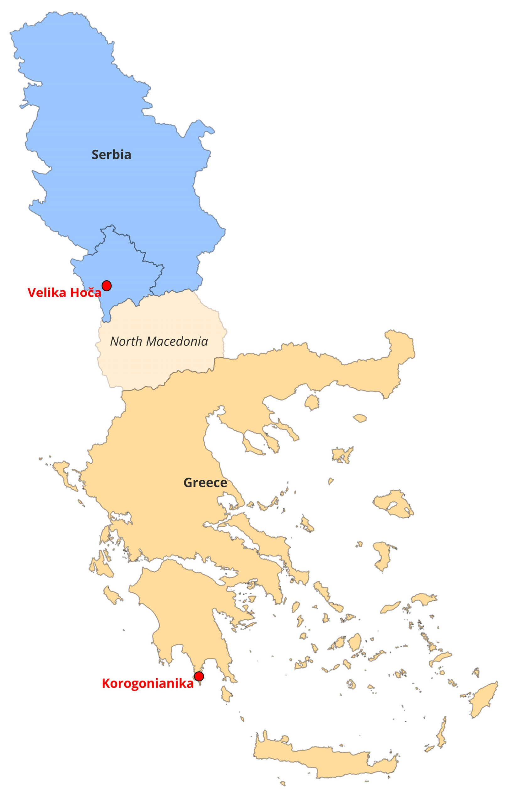
Two vernacular rural settlements from different Balkans regions, Korogonianika and Velika Hoča (Figure 3), were selected as case studies to validate the application of the LPP.
The selection of cases was based on their relevance to the research objectives and the capacity to illustrate the application of the LPP assessment framework. The selection process was guided by four core considerations: the presence of vernacular values; evidence of historical continuity and strong expressions of cultural identity; signs of exclusion or neglect within national and regional sustainability agendas; and differing political, administrative and legal contexts that offer a range of conditions for comparative reflection.
Together, Korogonianika and Velika Hoča reflect both the diversity of rural settlements in the Balkans and the shared struggles related to depopulation, modernization pressures and policy inattention.
To ensure the objectivity and methodological rigor of the assessment, a structured, mixed-method data synthesis strategy was employed, with each method providing complementary evidence to inform the qualitative assessment.
Statistical data collection was used to analyze quantifiable social trends, particularly demographic shifts and population structure, serving as the initial quantitative baseline against which qualitative findings were checked.
Policy review was essential for understanding the institutional and regulatory context surrounding the selected settlements.
Archival review was used to trace transformations over time, which was essential for comprehending the palimpsest layers of the settlements.
Literature review informed the historical, geographical and theoretical background of the studied settlements, grounding the analysis within existing academic discourse.
Fieldwork with systematic observation involved multiple on-site visits to the selected settlements. Observations analyzed spatial organization, architectural typologies, materiality and the physical condition of the built heritage. Informal mapping and photographic documentation recorded and interpreted current spatial patterns and visible, ongoing transformations.
Semi-structured conversations purposely targeted individuals whose knowledge correlated directly with the LPP’s four assessment categories, namely: local knowledge holders (long-term residents who primarily provided historical context on vernacular practices and social palimpsest layers); specialized local actors (entrepreneurs, business owners and association heads who primarily provided current data on the local economy and active heritage status); and officials (municipal and institutional representatives who primarily provided information on local policies and conditions related to environment, infrastructure and ecology). Across the two case studies, approximately 20 focused conversations were carried out during the fieldwork.
The final answers to the LPP’s qualitative indicator questions (Table 1, Table 2, Table 3 and Table 4) were not derived from a single opinion or source but were subject to convergent validation across different sources (archives, statistics, fieldwork, conversations). This approach renders the assessment as a qualitative-driven analysis based on a mixed-method foundation.
Finally, to enhance the objectivity and credibility of the final assessment, the synthesis of findings into the Living Palimpsest Report was subject to consensus verification among the research team. The multi-person verification mechanism involved cross-validation and iterative discussion of the interpretations, ensuring that the findings reflected a collective consensus interpretation of the assembled evidence and mitigating the risk of individual evaluator bias.
The applied holistic approach provided empirical basis for evaluating the palimpsest and the lived reality of the selected rural environments, revealing tensions between transformation, preservation and neglect.

4. Results and Discussion

The application of the Living Palimpsest Profile (LPP) methodology, detailed in Section 3, yielded two distinct assessment reports and subsequent action plans (visions) for the vernacular rural settlements of Korogonianika and Velika Hoča. The key strength of these reports lies in a holistic approach that seamlessly integrates a layered historical context with a systematic evaluation of all critical local sustainability dimensions. The findings were derived entirely from the structured, mixed-method data synthesis outlined in Section 3.2 (Case Study Analysis), utilizing convergent validation across statistical, policy, archival, the literature and fieldwork sources. Robust methodology allowed the indicators to successfully pinpoint inherent strengths and critical challenges of each settlement.

4.1. The Living Palimpsest Report for Korogonianika

4.1.1. Vernacular & Beauty Values

The vernacular settlements of Mani embody a long historical evolution shaped by cultural influences, socio-economic structures and defensive needs. Archaeological evidence indicates human presence in Eastern Mani since the Paleolithic and Neolithic periods [54], with significance during the Mycenaean era and the Bronze Age [55]. From the Early Christian period (ca. 330 A.D.), settlement layouts reflected both social organization and adaptation to rugged terrain [56]. During the Byzantine era (330–1453 A.D.), patriarchal clans relied on local resources, while defensive strategies shaped spatial and social hierarchies [56]. The Christianization of the 10th–12th centuries added religious and cultural dimensions to settlement identity. Subsequent periods introduced further influences: the Frankish Occupation (1249–1262) brought new organizational and architectural forms, while the Despotate of Mystras (14th–15th centuries) reinforced vernacular traditions, influencing the founding and naming of villages [56]. Across these periods, settlements were consistently shaped by the dual imperatives of cohesion and defense, expressed in clustered household layouts, fortified houses and tower structures marking family status and collective security [10].
Environmental conditions reinforced these historical patterns. The hot, dry summers of Mani demanded durable construction and careful orientation to reduce wind exposure [10]. Limited natural resources, particularly the availability of limestone and small amounts of timber, determined construction methods and strengthened the distinct vernacular architectural style [56]. Stone-built houses with sparse timber were durable and defensive, while the use of older building fragments ensured resource efficiency and continuity. Traditional builders in the region adapted their methods to the area’s strong seismic activity, making earthquake safety a central concern [57]. A major shift occurred around 1850, when lime plaster began to be used in stone masonry [56]. This not only strengthened walls, allowing them to be thinner, but also made possible the construction of internal load-bearing arches. These arches enabled wider rooms and improved living conditions. In addition, clustered layouts enabled collective defense and reflected the patriarchal inheritance system, where larger towers marked families with multiple male heirs. Inland siting further protected communities against pirate incursions, demonstrating the interdependence of climate, resources and security in shaping the settlement form.
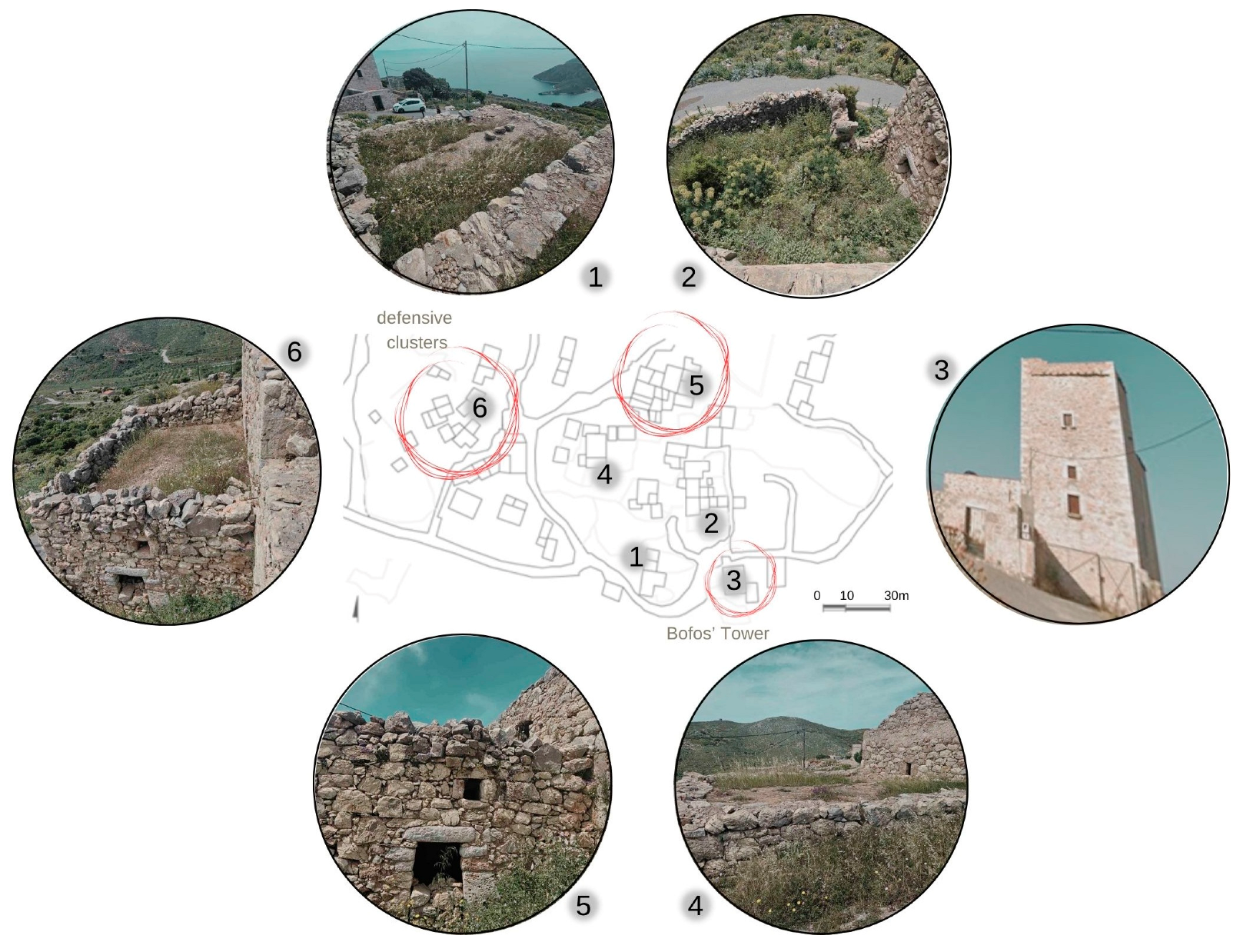
Korogonianika, situated at 350 m on a plateau of the Taygetos range, offers a representative case of this heritage. Its semi-mountainous terrain and geographic isolation reinforced an introverted, patriarchal clan structure, limited external exchange, and sustained defensive organization. According to the fieldwork, the village reached its present form in the 19th century, expanding around the Bofos tower, its only high-rise structure and defensive landmark (Figure 4). Houses of the same clan were deliberately clustered to form protective enclaves, illustrating the overlap of family identity and spatial organization.
Today, Korogonianika faces steep demographic decline. Once part of a district numbering 1776 inhabitants in 1856, the village now counts only four permanent residents, according to field work. Of its 32 building complexes, most are abandoned or used seasonally, with only two occupied year-round. This depopulation, mirrored across eastern Mani [58], threatens the survival of its distinctive vernacular architecture.
Despite this decline, Korogonianika and similar settlements remain vital as models of resilience, sustainability, and environmental adaptation. Their design reflects a balance of cultural identity, resource use, and defense, offering valuable lessons for contemporary living. Preserving this heritage not only safeguards cultural continuity but also provides inspiration for sustainable, community-based approaches to modern challenges. Acknowledging its unique value, the area of study has been protected under Law ΦΕΚ 594/Δ/78, as a site of heritage architecture, and all new constructions have to follow specific morphological regulations. Officially authorized architectural committees have to approve each and every intervention in the village, in an effort to preserve its identity.

4.1.2. Environment, Infrastructure and Ecology

Based on the Köppen–Geiger classification, the study area falls within the hot-summer Mediterranean climate zone [59]. Summers are characterized by high temperatures and persistently low humidity, while winters are moderate in temperature but frequently accompanied by strong winds. Vegetation is typical of arid Mediterranean ecosystems, dominated by indigenous shrubs such as thyme and prickly pear, with olive trees being the only indigenous arboreal species. Fertile soil is scarce and restricted to small, isolated patches. The area of study has been protected under the EU Birds Directive, established in March 2010, protecting 76 species. In addition, the wider area of Mesa Mani (GR2540008, Special Protection Area-SPA) is part of the NATURA 2000 network, where oak forests, shrublands and phrygana vegetation are predominant [60,61]. The village of Korogonianika lacks adequate water supply and wastewater management system. Moreover, road network in the Mesa Mani region, suffers from numerous inefficiencies that should be addressed in order to improve the quality of local infrastructure.

4.1.3. Social Dynamics

In the mid-20th century, Mani experienced significant internal migration as many residents left for urban centers or abroad in search of work and better living conditions [58]. This movement sharply reduced permanent populations in traditional settlements, leaving many villages sparsely inhabited or seasonally occupied. The decline weakened patriarchal clan structures that had long shaped social and spatial organization, while also interrupting the transmission of customs, skills, and collective memory between generations [62]. For villages such as Korogonianika, the impact was particularly visible. Once defined by tightly knit family networks and defensive clusters of dwellings, the settlement now faces widespread abandonment of houses and the gradual erosion of its vernacular architecture. With fewer residents to maintain buildings or communal spaces, preservation has become increasingly difficult. At the same time, migration distanced younger generations from their ancestral roots, further challenging cultural continuity and community resilience.

4.1.4. Local Economy

The rocky terrain and generally low soil fertility of Mani limited agricultural production, shaping both the socio-economic organization of its settlements and long-term patterns of migration. As the fieldwork revealed, families were often unable to rely on farming as a stable livelihood, which reinforced dependence on pastoral activities, trade, or external employment. The scarcity of arable land heightened the importance of collective resource management within clans and contributed to the gradual outflow of residents.
Within this challenging environment, olive trees played a crucial role. Cultivated in small fertile enclaves, they supported localized agricultural activity and provided one of the few reliable sources of income. Olive oil production, though limited in scale, became deeply embedded in the economic and cultural life of Mani, shaping seasonal work patterns and connecting isolated villages to broader trade networks. However, the restricted extent of cultivation in the majority of the Mesa Mani villages, meant that agriculture never achieved self-sufficiency, reinforcing both the need for migration and the resilience of local communities in balancing scarce resources. In Korogonianika, limited employment opportunities and scarce educational prospects accelerated population decline, leaving the village in a state of abandonment marked by numerous derelict buildings

4.2. The Living Palimpsest Report for Velika Hoča

4.2.1. Vernacular & Beauty Values

Velika Hoča (Hoča) was first mentioned in 1198 as a territory donated by the Serbian king Stefan Nemanja to the Hilandar Monastery in Greece [63]. At that time, Hoča lay on the boundary between Serbia and Byzantium [64]. Situated in a unique climatic context that blends continental and Mediterranean influences, making it highly suitable for viticulture, Hoča flourished during the late Middle Ages, developing into a significant economic, cultural and spiritual center [65]. The settlement experienced fluctuating periods of decline and prosperity throughout Ottoman rule [65]. A period of growth saw the construction of a large number of new houses during the 18th and the first half of the 19th century. However, this was followed by a phase of stagnation, despite most of the population continuing to engage in viticulture [66]. A major shift occurred post-World War II when the socialist system’s state-run industry dominated the economy. This prompted many residents to abandon agriculture for factory employment in the nearby town of Orahovac, resulting in the stagnation of Hoča’s autonomous development until the end of the 20th century. The subsequent major social conflict led to factory closures, leaving many residents unemployed and forcing a return to their local natural, human and cultural resources. Consequently, Hočans rediscovered the fertile soil, traditional winemaking, and the tangible heritage of their settlement. After prolonged dormancy, the community has, over the past two and a half decades, begun to re-evaluate and re-utilize the settlement’s vernacular/heritage values (Figure 5) as a means of survival and resilience.
The renewed appreciation for local values is supported by Hoča’s landscape, which is exceptionally rich in built heritage, categorized into three primary types: religious, industrial, and vernacular residential heritage. According to historical records, there were dozens of churches and monasteries on the territory of Velika Hoča during the Middle Ages. Today, eight churches are fully preserved, with the remains of five others visible. This makes Hoča a rare example of a settlement with a large concentration of religious buildings. The oldest preserved church dates back to the 13th century. While only some churches hold official status as protected cultural property, all of them are nevertheless recognized as heritage and are well-preserved due to the active engagement of the local community and relevant institutions.
Viticulture and wine production have a long and continuous history dating back to antiquity. The earliest archaeological evidence, such as the discovery of large amphorae, points to the ancient Roman period [63]. During the Middle Ages, Hoča was an important stop on the imperial road to Prizren, then a royal capital, serving as a public market for various goods, including wine [65]. However, little remains of this historical trade practice today. During the medieval period, almost every landowner in Hoča had his own winery for grape processing [65]. Today, the oldest existing wineries, known as ‘vinice’, represent massive stone buildings with porches dating from the 18th or 19th centuries.
The vernacular houses of Velika Hoča represent another significant component of the community’s cultural heritage, showcasing its long history and resilience. Most existing houses date to the 18th and 19th centuries. Stone, wood, and a mix of clay and straw (known as ‘ćerpič’) were the primary construction materials. Two-story houses were built with a stone ground floor and a timber-framed upper story. Larger houses adopted urban style, featuring balanced proportions, an orderly arrangement of openings, a porch on the ground floor, and a balcony (‘čardak’) on the upper. House design represented a direct response to the local climate and residents’ needs. The ground floor was typically reserved for livestock, with the living space located on the warmer upper floor. Uniquely, many houses included hidden rooms and evacuation exits—essential features during volatile periods, particularly under Ottoman rule—as well as integrated wine cellars.
Despite cultural significance [63], the traditional houses of Velika Hoča lack formal protection. While many of these structures still exist, they are rapidly deteriorating, being renovated without a preservation plan or replaced by new, modern buildings. Only an estimated 10 houses have been restored in a manner that preserves their original value. The lack of protection for residential heritage is multifaceted: there are no specific regulations, and the structures have not been sufficiently researched or documented.
In a measure of protection, a special law designates Velika Hoča as a permanent cultural and religious heritage site and a protected zone. The law imposes strict prohibitions on new development, including bans on residential parcel consolidation, industrial construction, environmental pollution, and overly large buildings, while also restricting permanent advertising. New construction permits must be approved by both the local municipality and a special municipal council, which includes Hoča’s residents and is responsible for heritage protection. However, while this council is the only local entity exclusively focused on heritage, the law itself fails to provide a detailed framework for protecting vernacular heritage, notably overlooking the safeguarding of traditional houses. Other local institutions, such as the local cultural center and museum, have broader mandates not exclusively focused on heritage preservation.
Hoča is also rich in intangible heritage, with numerous practices and traditions tied to the settlement [63], primarily in the areas of viticulture and winemaking, along with the customs that accompany them.
The community of Hoča remains fundamentally rooted in tradition and historical continuity. Residents identify as Hočans, viewing their historical status as distinct, which fosters a strong sense of identity and self-respect. Their deep religious faith, including a belief in divine protection and witnessed miracles, is a critical factor in the resolve to remain in the settlement. The connection to heritage is demonstrated through residents’ reliance on traditional architecture and cultural assets, particularly the numerous churches, which they use to highlight social significance. Simultaneously, Hočans employ modern channels to promote their authentic values and hospitality to tourists.
The Hočans, including youth, actively cultivate their intangible heritage. This practice is reinforced by the establishment of associations dedicated to crafts and customs, and by the organization of various public events, such as rituals, exhibitions, concerts and festivals. Furthermore, emerging initiatives are instrumental in preserving tradition and social cohesion, aiming to engage youth and generate novel strategies for community advancement.

4.2.2. Environment, Infrastructure and Ecology

The documentation on the spatial evolution of Hoča is very scarce. During the Middle Ages, Hoča was composed of scattered estates with elements of fortification for security. With the arrival of the Ottomans, the settlement began to consolidate for safety, evolving into its current compact form. The residential parcels in Hoča are small, their shapes dictated by the street network and local topography. Within the village’s administrative area, the central settlement is clearly distinct from the surrounding agricultural land. The agrarian landscape, dominated by vineyards, crop fields and forests, is highly valuable and protected under the same law.
Due to the aforementioned law and population stagnation, the village is not expanding but rather exhibits spatial stagnation in size, with new construction frequently occurring on or near the sites of previous older structures.
The settlement is accessible and connected by a road network. Public inter-city transportation links Hoča to larger centers, though no public transport exists within the settlement itself. Historical records indicate that during the Middle Ages, its connectivity was excellent, particularly via the Imperial Road, which still follows the route to the city of Prizren. Current vehicular traffic is not heavy, and the road profiles are constrained by the surrounding built structures. The streets are covered by asphalt or concrete tiles, which have replaced the previous cobblestone. Pedestrian paths are limited to the main street. There are no dedicated bicycle lanes or public parking areas.
Infrastructure has only recently improved. The public water supply network is supplemented by household wells, which are still used for technical and agricultural purposes. Electricity is sourced from distant power plants. While waste removal is regulated and modern telecommunication networks are available, the community lacks wastewater treatment, and its partially developed sewage system still relies on septic tanks.
There are no sources of industrial pollution within the settlement. Point source pollutants originate from individual households using conventional heating systems. While organic farming is present, it is not yet commercialized. The region is rich in flora and fauna, but plans for their formal listing, protection and enhancement are still in development.
No formal environmental regulations or practices mandate adherence to ecological sustainability and circularity principles in new construction or maintenance. The reconstruction of a few old houses using original, refurbished materials represents the only exception to this trend.
In the central zone, around the recently established and equipped square and along the main street, are the community’s vital facilities: churches, the school, the cultural center, the museum, wineries, and hospitality venues. The village lacks traditional parks. A playground is available within the schoolyard, but children often utilize the central square for play. Young residents gather through the activities of local organizations and a youth center.
The security situation has improved over time relative to the period of intense conflicts and security problems experienced in the late 20th and early 21st centuries. In its geopolitical context, Velika Hoča represents an ethnic enclave.
Visually, Hoča presents a spatial composition characterized by a mix of new construction and historical structures. While traditional architecture continues to dominate the main street, its integrity is interrupted by a few permanent or temporary non-traditional elements. A more significant architectural challenge arose in the 1980s and continued into the 21st century, where later, architecturally incompatible construction, utilizing modern materials [67], began to proliferate. These new structures deviate from Velika Hoča’s traditional architectural style, thereby compromising local heritage and the landscape. Crucially, there are no regulations currently in place to embed vernacular values into new construction.
Public services, particularly healthcare and education, represent the most significant issues for the residents. Although Hočans have equal access to services, the village itself only houses an elementary school and a local health unit. For secondary education and specialized medical services, residents are compelled to travel to urban centers.
Decisions regarding the settlement’s development are primarily driven by the initiatives of individuals and local organizations. However, this system remains far from a transparent and inclusive process for all inhabitants.
The settlement possesses sufficient potential for food production; nevertheless, it remains externally dependent in terms of water and electricity supply. A massive transformation is needed to redirect future development toward greater self-sufficiency, a goal that cannot be accomplished in isolation but demands a broader regional approach.

4.2.3. Social Dynamics

Velika Hoča faces demographic decline and an aging population, with a significant reduction in its resident base over the last 50 years. The settlement lacks an influx of new residents; instead, out-migration of young people for education and employment is common. A substantial number of graduates do not return, which hinders both the community’s size and its educational profile. While various support programs have been implemented for individuals and families, none have explicitly targeted the organized return of former residents. The confluence of demographic trends, fragmented development, and an underdeveloped social system risk accelerating the rate of emigration.
Despite the demographic challenges, residents exhibit a strong sense of pride, collective identity, and place attachment. This cohesion is rooted in two key factors: the productive landscape and heritage, and a shared history of survival through difficult periods. Daily life is characterized by high intergenerational social interaction and mutual assistance in agricultural activities, a cultural practice common across the Balkan region. Various community events, often centered on religious holidays, are organized communally in public spaces, including the main square, the cultural center (with its summer stage), and streets. This practice, along with the preservation of traditional values within families, contributes significantly to the continuity and identity of the community.
Hoča’s community has demonstrated adaptability, evidenced by the rise of new thematic associations focused on heritage and wine production. The re-emergence of wine cooperatives in the 21st century has revived a tradition of economic association from the latter half of the 20th century while simultaneously fostering new social practices. The community’s openness to new ideas and its traditional hospitality are reflected in the growth of tourism and the successful implementation of initiatives aimed at sustaining the settlement after the 1999 conflict. Numerous multi-actor efforts undertaken to date have successfully restored Hoča’s image as a place of rich heritage and a long-standing tradition of wine production.

4.2.4. Local Economy

Historically, the local economy of Hoča was built upon a diverse range of activities, including crafts (such as masonry and stone carving), trade, agriculture and winemaking. Over time, however, only viticulture and winemaking have persisted, albeit with fluctuating periods of growth and decline. The traditional crafts have disappeared, and trade has been largely supplanted by tourism, which emerged as a new economic driver.
The past two decades have seen a rise in local entrepreneurship, primarily fueled by external programs designed to foster new businesses. Today, winemaking and tourism are the principal economic activities, resulting in a highly specialized yet simplified economic system. Over half of the working-age population is employed in these two sectors, with viniculture being dominant. Nevertheless, the lack of job diversity makes the local economy particularly vulnerable.
The local wine sector has seen significant modernization, including the establishment of new wineries, the adoption of modern winemaking technologies, and enhanced capacity for tourism services. As a result, Hoča wine has developed into a recognizable and widely marketed brand. Simultaneously, Hoča has gained popularity as a tourist destination, thanks to its rich heritage, history and natural landscape, supported by comprehensive cultural promotion. Tourists from across the Balkan region are drawn to the area for religious and wine tourism. However, current capacities are insufficient to support the growing number of visitors, with a notable shortage of accommodation and dining services. A few vernacular structures have been converted into tourism facilities with external support, but this valuable local cultural resource remains largely underutilized. Systemic programs are needed to incentivize investment in the renovation of vernacular houses.
The job market is predominantly private, which contributes to gradual economic fragmentation within the community. While land concentration is not problematic, opportunities for employment outside of winemaking and tourism are scarce. Despite the experienced growth, the local economy is approaching stagnation. From a sustainability perspective, this could have numerous negative implications in the future. Even if the number of winery owners continues to increase, the limited availability of the core natural resource—arable land suitable for vineyards—imposes a ceiling on this sector’s growth. Introducing other economic alternatives is crucial for long-term resilience.

4.3. Analytical Interpretation of Layered Interactions

The presented reports indicate that the LPP method is effective for analyzing and documenting the unique development, transformation and current status of vernacular rural communities. Specifically, the palimpsest component functions as an analytical tool that can be used to explain how historical and modern layers interact. By analyzing concepts like overwriting, hybridization and conflict, it becomes possible to identify sources of vulnerability and resilience in each settlement.
In Korogonianika, the historical layers are defined by loss and structural conflict. The most profound interaction is the overwriting of the physical layer (vernacular architecture) by the social layer (absence of community). Depopulation represents a structural failure: the dense, fortified house clusters, originally a layer of cohesion and defense, are now layers of abandonment and vulnerability. The current demographic layer (four permanent residents) is too sparse to maintain the complex, robust ‘text’ of the previous centuries, leading to the active erasure of the built heritage through decay.
The formal protection granted by law exists in structural juxtaposition with the local reality. The layer of policy preservation is powerless against the dominant force of economic collapse and social disintegration. The policy fails to ensure functional continuity, effectively preserving a dying artifact rather than a living settlement.
The strength is found in the hybridity of the building techniques. The shift to lime plaster and load-bearing arches was a technical hybridization of traditional stone masonry and structural innovation, improving living conditions. This historical layer of Korogonianika provides lessons for future sustainable retrofitting.
In Velika Hoča, the narrative is one of sustained cultural continuity achieved through functional and structural hybridization of assets, contrasting sharply with moments of external conflict.
The most significant interaction is the hybridization of the economic layer. The community, forced to return to local resources after factory closures, actively chose to re-read the original agricultural and spiritual layers of the palimpsest. The traditional layer of viticulture and the industrial layer of the vinice (historic massive stone buildings) have been overlaid by a 21st century market layer (modern technology, branding and tourism). Vinice are functionally hybridized, evolving from simple processing structures to modern, branded tourist destinations.
The traditional layer of collective resilience in Hoča is sustained and reinforced by modern social layers, evidenced by the rise of new thematic associations and the use of digital promotion. This enduring strength is rooted in intangible heritage, including historical mechanisms for survival [63]. The blend of past necessities with modern tools underscores the community’s persistent fight for survival.
Hoča’s challenges stem from the conflict and juxtaposition between layers added during the period of industrial prosperity and those driven by heritage recovery. The architecturally incompatible construction since the 1980s represents a layer of overwriting that deviates from the traditional style, placing layers of aesthetic conflict directly adjacent to the authentic vernacular fabric. The formal special protection law for Hoča ensures legal integrity but is undermined by the lack of regulations to enforce vernacular values in new construction.

4.4. Derivation and Contextual Differentiation of the Frameworks of Visions

The process of deriving the Frameworks of Visions marks the critical transition from the Living Palimpsest Reports (Section 4.1 and Section 4.2) and the Analytic Diagnosis (Section 4.3) to actionable planning. The derivation utilizes the structured analytical process detailed in Section 3.1; specific challenges and assets (positive attributes) identified in the Living Palimpsest Reports are inverted and synthesized to formulate the hierarchical visions.
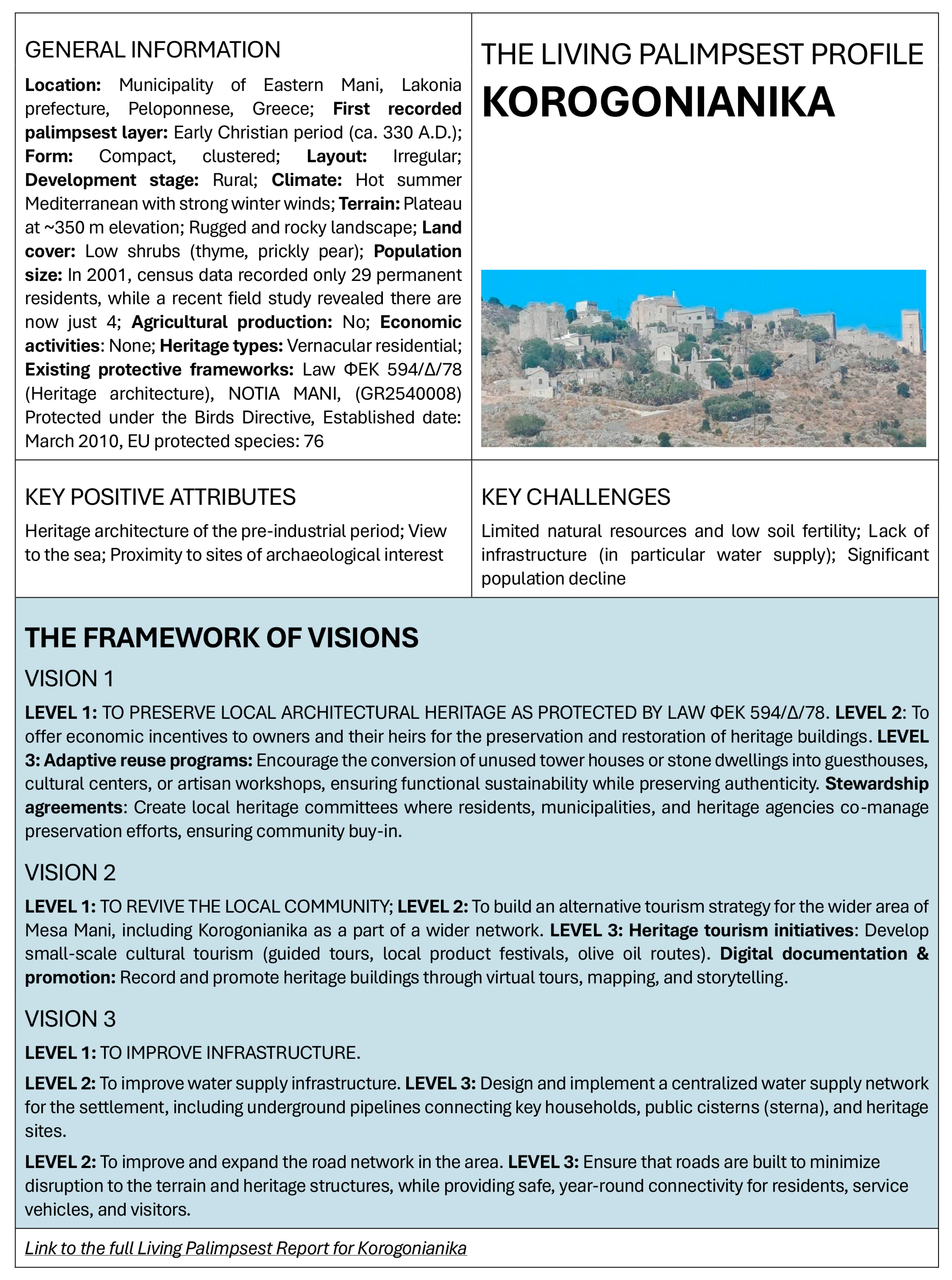
Figure 6 and Figure 7 feature the composed Framework of Visions for Korogonianika and Velika Hoča. This visually appealing format contains essential settlement information, an internal capacity assessment and the foundational concepts of the visions. Standardized presentation not only makes the results accessible but also facilitates a comparison among different rural settlements.
While derived from the same methodology, the LPP reports for Korogonianika and Velika Hoča diverge significantly, reflecting the unique challenges and resources in each settlement. The demonstrated LPP’s core strength—its sensitivity to context—results in two distinct developmental directions that prioritize different Sustainable Development Goals (SDGs) and targets. The key difference in LPP reports is one of an existential crisis (Korogonianika) versus revitalization growth (Velika Hoča). Korogonianika’s vision is a survival-and-stabilization plan that primarily supports SDG 6 (Clean Water and Sanitation). On the other side, Hoča’s vision, benefiting from greater socio-cultural cohesion, is a revitalization and diversification plan that supports SDG 8 (Decent Work and Economic Growth). In both settlements, nevertheless, SDG 11 and its targets are central. Specifically, common SDG Target 11.4, referring to heritage protection and the sustainable utilization, reflects the high vernacular value of both Korogonianika and Velika Hoča, and is likely to be a priority for most other vernacular Balkans settlements. Other common SDG targets for Korogonianika and Hoča include SDG Target 8.9 (Sustainable and beneficial tourism), and SDG Target 9.1 (Development of sustainable, resilient and inclusive infrastructures).

4.5. LPP Limitations, Transferability and Digital Operationalization

While the LPP successfully validated its methodological rigor and contextual sensitivity, the application revealed several inherent limitations and barriers that must be acknowledged for future development.
The primary barrier to a simplified, universal comparative analysis is the model’s intentional reliance on qualitative findings. In regions like the Balkans, where rural data is frequently scarce and unreliable, the qualitative indicators provide a logical and essential starting point. Descriptive assessment pathways effectively identify critical rural values and issues, along with their underlying causes and consequences. However, the significant disparity in the results from the two case studies precludes the immediate establishment of a common quantitative metric or score system based on these findings alone.
Another notable current limitation is the lack of temporal digital data (GIS layers), which restricts the palimpsest analysis to archival and narrative sources rather than dynamic spatial modeling.
Consequently, the LPP currently functions as a crucial initial assessment instrument that defines priorities. Future case study research is thus required to clarify commonalities and, subsequently, to formulate a set of focused, quantitative indicators (comparable to established frameworks like the Agricultural Sustainability Compass [28] or OECD Agri-Environmental Indicators [29]). These new metrics can then be integrated into the developed assessment model. In the interim, future efforts should combine the developed qualitative indicators with other available, general quantitative sets (e.g., the EU Sustainable Development Indicators [27] and the UN Global Indicator Framework for the Sustainable Development Goals [26]). Additionally, the Framework of Visions component can serve as a preparatory foundation for future, sustainability-oriented projects. It is only once these projects are underway that available SRTs (e.g., [32,33]) or the NEB Self-Assessment Method [52] can be effectively deployed to measure sustainability within a specific vernacular rural context.
The LPP reports obtained for Korogonianika and Velika Hoča furnish the critical context necessary to comprehend their unique conditions and challenges. The model offers broad applicability, ranging from self-assessment and scientific inquiry to informing local and regional policy formulation. At the local level, decision-makers can utilize the LPP to establish evidence-based development trajectories. Regionally, the model’s capacity to simultaneously analyze and compare multiple villages positions it as a suitable instrument for broader spatial planning. Namely, although the LPP does not generate a single comparative score, it enables policymakers to conduct robust comparisons based on the type of need and the required intervention. For example, regional authorities can compare all settlements whose Framework of Visions prioritize SDG 6 (Water/Sanitation) to strategically allocate immediate infrastructure funding, or contrast those whose primary challenge is the social palimpsest to prioritize cultural investment. This allows for policy segmentation based on functional necessity rather than standardized metrics.
The case studies validated the LPP’s sensitivity to regional diversity; however, the framework’s methodological design offers significant transferability and generalizability beyond the Balkans. The LPP’s robustness lies in its ability to preserve rigorous character in conditions where standardized data are non-existent, incomplete or unreliable. Therefore, the LPP can also be understood as a contextualization tool for any region where unique vernacular heritage faces challenges due to data scarcity coupled with pronounced present-day environmental, social and economic pressures. The applicability of the framework in different geographical contexts is rooted in its local sensitivity and the structured capture of nuanced data, as well as in its methodological strength. Ultimately, this allows stakeholders to base visions and action on local reality rather than standardized metrics. Nevertheless, to implement the LPP in other areas, a preliminary investigation of the local/regional context is required, and questions specific to that spatial context must be adapted, precisely as was done in this research.
The development of a GIS-based digital LPP could be the primary direction to resolve current analytical and comparative limitations of the developed assessment framework.

Developing a GIS-Based Digital LPP

The Geographic Information System (GIS) is an indispensable tool for the future operationalization of the LPP, allowing the complex theoretical framework to be transformed into an exact, spatially defined model. The LPP methodology, which aims to decipher the stratification of a vernacular settlement by viewing it as a palimpsest, is fundamentally analogous to the layered structure of GIS. The primary limitation of temporal analysis in GIS is often the scarcity of reliable and evenly distributed historical data [68]. The LPP methodology, by providing necessary reports and rigorously collected data, acts as the first step toward precise spatial GIS analysis [69] and contributes to the development of improved temporal maps.
The analytical capabilities of the GIS-based LPP can be structured as fully compatible with the core assessment categories:
  • Vernacular & Beauty Values Layer can enable mapping of the settlement’s history and evolution. It can provide historical/evolution mapping (georeferencing old plans for change detection), the heritage and risk layer (mapping protected sites and natural threats), and the intangible heritage layer (geocoding locations of traditional crafts and cultural practices) to define restoration priorities.
  • Environment, Infrastructure and Ecology Layer can fuse essential spatial data to diagnose system vulnerabilities. For example, it can provide infrastructure and accessibility maps (measuring utility networks and service distribution), the environmental constraints layer (identifying protected areas, biodiversity and soil quality), and resource vulnerability mapping (locating critical water sources and ecological stressors).
  • Social Dynamics Layer can be used to capture the spatial patterns of community cohesion and change. For example, it can integrate demographic change mapping (geocoding population shifts and migration flows), the social palimpsest layer (visualizing historical locations of social interaction, organization and divisions), and accessibility analysis (revealing inequality in resource distribution among different social groups).
  • Local Economy Layer can visualize the spatial structure of the economy, particularly its relationship with history and resources. It can integrate economic palimpsest mapping (visualizing historic economic transformation and coexistence/conflict between old and new businesses), resource vulnerability (mapping arable land suitability), and clustering analysis (identifying zones of economic potential and risks).
However, the effectiveness of the digital LPP depends on integrating a complete set of data through a combined approach. This involves basic spatial data (cadastral data, DEM, satellite imagery) as the foundation; attribute and quantitative data (demographics, economic figures, heritage attributes) stored in tables; and crucially, qualitative and georeferenced data derived from interviews and surveys. This last group transforms intangible data, such as a sense of attachment, into visual layers.
Overall, the role of GIS extends beyond mere mapping to include sophisticated spatial synthesis. One function is the visualization of the invisible, through which GIS transforms intangible data into visual layers. Another is multi-criteria analysis, which combines multiple layers, e.g., a heritage layer, a landslide risk layer, and an infrastructure accessibility layer, to generate a single map of protection and intervention priorities, directly supporting the logic of the Framework of Visions. Finally, continuity and conflict analysis uses spatial autocorrelation to reveal whether new palimpsest layers are fragmented or integrated into the existing core. Ultimately, the application of GIS can transform the complex LPP from a theoretical concept into an exact, spatially defined model that provides a solid basis for preparing planning documents and making sustainable decisions for vernacular rural settlements.

5. Conclusions

This research successfully set out to develop and validate a novel, context-sensitive assessment framework for vernacular rural settlements, the Living Palimpsest Profile (LPP). The LPP’s resulting strength lies in its ability to provide a comprehensive understanding of sustainability both through time and space, which is of immense significance for vernacular settlements given their unique historical value and the contemporary challenges they face.
The finalized assessment model, which fulfills the research aim, comprises two parts. The first consists of qualitative indicators structured into four categories: Vernacular & Beauty Values; Environment, Infrastructure and Ecology; Social Dynamics; and Local Economy. The questions are flexible, fine-tuned to the Balkans region, and split between a specific sustainability aspect and the application of the palimpsest metaphor to that aspect. Answering them yields a descriptive and critically evaluative sustainability assessment, the Living Palimpsest Report. The second part is a Framework of Visions, which translates the report’s findings into a three-level hierarchical plan with actionable directions for a settlement’s sustainable development.
The model was rigorously tested on two distinct Balkan vernacular settlements, Korogonianika and Velika Hoča. Applying the methodology produced a Living Palimpsest Report for each settlement, which provided a detailed look into the complex aspects of sustainability and its palimpsest layers. The qualitative findings were subjected to convergent validation, synthesized from mixed-method inputs and confirmed through team cross-validation. Assessment indicators proved sensitive enough to capture important details and comprehensive enough to place them within a meaningful context. The reports also allowed for a clear differentiation between the two settlements, leading to the creation of two distinct Frameworks of Visions. This finding proves that, despite its general nature, the model is both effective and highly sensitive to the unique specificities of individual contexts.
Broadly, this research demonstrates that genuine and lasting sustainability requires a fundamental theoretical shift in perspective. The LPP is not just an assessment framework; it is a new paradigm that reframes sustainability as a dynamic, layered process. By integrating the palimpsest metaphor, the LPP deepens concepts such as rural resilience (reframed as layered adaptation, or the capacity to manage cumulative change) and cultural conservation (redefined as dynamic conservation, managing the interaction of layers for continued functional relevance). The methodology thus provides a roadmap for understanding a settlement’s history and empowering its community to build a resilient future.
The model proves that for vernacular settlements and all heritage-rich environments, sustainability cannot be imposed through one-size-fits-all metrics. Instead, it must be cultivated from within, by leveraging a community’s deep-rooted identity and its connection to place. Thus, the LPP offers a flexible blueprint for vulnerable communities to transform their narratives of decline into a new chapter of resilience and sustained vitality.
To ensure the framework remains future-proof and scalable, the LPP methodology provides a clear roadmap for advancing from qualitative assessment to large-scale operationalization. The rigorous methodological approach undertaken provides a solid, verifiable data set, overcoming the initial challenge of data scarcity. This robust foundation makes the LPP framework immediately suitable for digital operationalization through a GIS-based assessment platform. That way, the LPP transforms from a context-sensitive diagnostic tool into an exact, spatially defined model, ready for strategic policy implementation and comparative planning across multiple regional and international settings.

Author Contributions

Conceptualization, E.T.; methodology, S.K., E.T., Đ.M. and G.H.; validation, S.K., E.T., M.G., Đ.M., P.P. and G.H.; formal analysis, M.G., E.T., S.K., Đ.M., P.P. and G.H.; investigation, S.K., E.T., M.G., Đ.M., P.P. and G.H.; resources, S.K., E.T., M.G., Đ.M., P.P. and G.H.; data curation, M.G., E.T., S.K. and G.H.; writing—original draft preparation, S.K., E.T., M.G. and G.H.; writing—review and editing, S.K., E.T., M.G., Đ.M., P.P. and G.H.; visualization, S.K., E.T., M.G., Đ.M., P.P. and G.H.; supervision, S.K., E.T. and G.H. All authors have read and agreed to the published version of the manuscript.

Funding

This research received no external funding.

Data Availability Statement

All main research data are included in this paper. Supplementary data are available upon request from the corresponding author.

Acknowledgments

Authors Saja Kosanović, Miloš Gvozdić and Đurica Marković would like to thank the Ministry of Science, Technological Development and Innovation of the Republic of Serbia for funding the scientific research work, Contract No. 451-03-18/2025-03/200155, realized by the Faculty of Technical Sciences—University of Priština in Kosovska Mitrovica. Authors Evgenia Tousi, George Hloupis and Panagiotis Papantoniou, would like to thank the Special Accounts for Research Grants, University of West Attica for financially supporting this publication.

Conflicts of Interest

The authors declare no conflicts of interest.

Abbreviations

The following abbreviations are used in this manuscript:
LPPThe Living Palimpsest Profile
SDGsSustainable Development Goals
GIS Geographic Information System
UNUnited Nations
EUEuropean Union
OECDOrganization for Economic Co-operation and Development
SRTsSustainability Rating Tools
BREEAMBuilding Research Establishment Environmental Assessment Method
LEEDLeadership in Energy and Environmental Design
LEED-NDLeadership in Energy and Environmental Design for Neighborhood Development
DGNB-UDDeutsche Gesellschaft für Nachhaltiges Bauen for Urban Districts
NEBNew European Bauhaus
DEMDigital Elevation Model

References

  1. Brown, D.L.; Schucksmith, M. A New Lens for Examining Rural Change. Eur. Countrys. 2016, 8, 183–188. [Google Scholar] [CrossRef]
  2. Ahlmeyer, F.; Volgmann, K. What Can We Expect for the Development of Rural Areas in Europe?—Trends of the Last Decade and Their Opportunities for Rural Regeneration. Sustainability 2023, 15, 5485. [Google Scholar] [CrossRef]
  3. Delgado Viñas, C. Depopulation Processes in European Rural Areas: A Case Study of Cantabria (Spain). Eur. Countrys. 2019, 11, 341–369. [Google Scholar] [CrossRef]
  4. Martinovska Stojcheska, A.; Zhllima, E.; Kotevska, A.; Imami, D. Western Balkans Agriculture and Rural Development Policy in the Context of EU integration—The Case of Albania and North Macedonia. RSPP Reg. Sci. Policy Pract. 2024, 16, 100049. [Google Scholar] [CrossRef]
  5. Mickovic, B.; Mijanovic, D.; Spalevic, V.; Skataric, G.; Dudic, B. Contribution to the Analysis of Depopulation in Rural Areas of the Balkans: Case Study of the Municipality of Niksic, Montenegro. Sustainability 2020, 12, 3328. [Google Scholar] [CrossRef]
  6. Živanović, Z.; Tošić, B.; Vesić, M. Rural Abandonment in the Balkans: Case Study of a Serbian Village. J. Fam. Hist. 2021, 46, 344–362. [Google Scholar] [CrossRef]
  7. Yarkova, Y.; Mutafov, E. Rural Areas in Bulgaria—Investigation on some Factors for Development. East. Eur. Countrys. 2017, 23, 51–70. [Google Scholar] [CrossRef]
  8. Paul, L. Rural Development in Romania—A Few Considerations. Stud. Bus. Econ. 2020, 15, 165–174. [Google Scholar] [CrossRef]
  9. Kosanović, S.; Folić, B.; Kovačević, S.; Nikolić, I.; Folić, L. A Study on the Sustainability of the Traditional Sirinić Houses in the Šar Mountain Region, the South-Western Balkans. Sustainability 2019, 11, 4711. [Google Scholar] [CrossRef]
  10. Tousi, E. Interaction Among Social, Cultural and Environmental Factors in Vernacular Settlements. The Case of Korogonianika, in Lakonia, Greece. J. Sustain. Archit. Civ. Eng. 2020, 27, 32–39. [Google Scholar] [CrossRef]
  11. Daskalova, T. The Heritage of the Bulgarian Revival in the Central Balkans Region: Vernacular Architecture—Restoration Issues and Revitalization Challenges. Mater. Res. Proc. 2025, 47, 6–14. [Google Scholar] [CrossRef]
  12. Rajković, I. Whose Death, Whose Eco-Revival? Filling in While Emptying Out the Depopulated Balkan Mountains. Focaal—J. Glob. Hist. Anthropol. 2023, 96, 71–87. [Google Scholar] [CrossRef]
  13. United States Environmental Protection Agency. Smart Growth Self-Assessment for Rural Communities. Available online: https://www.epa.gov/sites/default/files/2015-12/documents/rural_self_assessment_121815.pdf (accessed on 15 September 2025).
  14. Nelson, K.S.; Nguyen, T.D.; Francois, J.R.; Ojha, S. Rural Sustainability Methods, Drivers, and Outcomes: A Systematic Review. Sustain. Dev. 2023, 31, 1226–1249. [Google Scholar] [CrossRef]
  15. Ciampa, F.; Marchiano, G.; Girard, L.F.; Angrisano, M. The Rural Village Regeneration for the European Built Environment: From Good Practices Towards a Conceptual Model. Sustainability 2025, 17, 2787. [Google Scholar] [CrossRef]
  16. Coenen, F. Local Agenda 21: ‘Meaningful and Effective’ Participation? In Public Participation and Better Environmental Decisions; Coenen, F.H.J.M., Ed.; Springer: Dordrecht, The Netherlands, 2009; pp. 165–182. [Google Scholar] [CrossRef]
  17. Cavalieri, C.; Cogato Lanza, E. Territories in Time: Mapping Palimpsest Horizons. Urban Plan. 2020, 5, 94–98. [Google Scholar] [CrossRef]
  18. Marot, S. Envisioning Hyperlandscapes; Harvard Design Magazine: Cambridge, MA, USA, 2013; p. 36. Available online: https://hal.science/hal-03506052/document (accessed on 17 August 2025).
  19. Layne, M.K. The Textual Ecology of the Palimpsest. Environmental Entanglement of Present and Past. Aisthesis—Riv. Line Del Semin. Perm. Estet. 2014, 7, 63–72. Available online: https://oajournals.fupress.net/index.php/aisthesis/article/view/845/843 (accessed on 17 August 2025).
  20. Dillon, S. The Palimpsest: Literature, Criticism, Theory; Continuum: London, UK, 2007. [Google Scholar]
  21. Tan, D.; Nguyen, M.Q. Beyond the Palimpsest: Traditions and Modernity in Urban Villages of Shenzhen, China. Cities 2024, 151, 105093. [Google Scholar] [CrossRef]
  22. Wilkinson, T.C.; Slawisch, A. An Agro-Pastoral Palimpsest: New Insights into the Historical Rural Economy of the Milesian Peninsula from Aerial and Remote-Sensing Imagery. Anatol. Stud. 2020, 70, 181–206. [Google Scholar] [CrossRef]
  23. Humpal, T.M. Shi-Gol: The Rural Palimpsest and Historical Trauma in the Contemporary Korean Horror Film. Ph.D. Dissertation, University of Southampton, Southampton, UK, 2023. [Google Scholar]
  24. Chatzinikolaou, P.; Manos, B.D.; Bournaris, T. Classification of rural areas in Europe using social sustainability indicators. In Proceedings of the 1st AIEAA Conference—Towards a Sustainable Bio-Economy: Economic Issues and Policy Challenges, Trento, Italy, 4–5 June 2012; Available online: https://ageconsearch.umn.edu/record/124104/?v=pdf (accessed on 17 August 2025).
  25. Memo, U.; Pieńkowski, D. Sustainable Rural Development Indicators in Bulgaria, Germany, Poland, Romania and the Netherlands: A Review of Data. Front. Environ. Sci. 2023, 11, 1323688. [Google Scholar] [CrossRef]
  26. United Nations General Assembly. Annex of the Resolution Adopted by the General Assembly on 6 July 2017: Global Indicator Framework for the Sustainable Development Goals and Targets of the 2030 Agenda for Sustainable Development. Available online: https://docs.un.org/en/A/RES/71/313 (accessed on 20 September 2025).
  27. Eurostat. Sustainable Development Goals. Database. Available online: https://ec.europa.eu/eurostat/web/sdi/database (accessed on 20 September 2025).
  28. European Commission. Agri Sustainability Compass. Available online: https://agridata.ec.europa.eu/extensions/compass/compass.html (accessed on 5 September 2025).
  29. OECD. OECD Compendium of Agri-Environmental Indicators; OECD Publishing: Paris, France, 2013; Available online: https://www.oecd.org/content/dam/oecd/en/publications/reports/2013/06/oecd-compendium-of-agri-environmental-indicators_g1g220a0/9789264186217-en.pdf (accessed on 24 October 2025).
  30. Siew, R.Y.J. A Review of Sustainability Reporting Tools (SRTs) for Communities. IJSCET Int. J. Sustain. Constr. Eng. Technol. 2014, 5, 39–52. [Google Scholar]
  31. Khatibi, M.; Khaidzir, K.A.M.; Mahdzar, S.S.S. Measuring the Sustainability of Neighborhoods: A Systematic Literature Review. IScience 2023, 26, 105951. [Google Scholar] [CrossRef] [PubMed]
  32. BREEAM. BREEAM Communities. Technical Manual SD202. Available online: https://breeam.com/standards/communities (accessed on 19 August 2025).
  33. U.S. Green Building Council. LEED v4 for Neighborhood Development. Available online: https://www.usgbc.org/leed/rating-systems/neighborhood-development (accessed on 19 August 2025).
  34. Lee, J.; Park, J.; Schuetze, T. Comparative Analysis of LEED-ND & DGNB-UD Rating System. In Proceedings of the 8th Conference of the International Forum on Urbanism (IFoU) session True Smart & Green Urban Planning and Governance, C004, Incheon, Republic of Korea, 22–24 June 2015; pp. 235–248. [Google Scholar]
  35. Szibbo, N. Assessing Neighborhood Livability: Evidence from LEED® for Neighborhood Development and New Urbanist Communities. Artic. J. Urban Res. 2016, 14, 1–24. [Google Scholar] [CrossRef]
  36. Boeing, G.; Church, D.; Hubbard, H.; Mickens, J.; Rudis, L. LEED-ND and Livability Revisited. Berkeley Plan. J. 2014, 27, 31–55. [Google Scholar] [CrossRef]
  37. Berardi, U. Sustainability Assessment of Urban Communities Through Rating Systems. Environ. Dev. Sustain. 2013, 15, 1573–1591. [Google Scholar] [CrossRef]
  38. Lynch, K. The Image of the City; MIT Press, Massachusetts Institute of Technology: Cambridge, MA, USA; London, UK, 1960. [Google Scholar]
  39. Jacobs, J. The Death and Life of Great American Cities; Random House: New York, NY, USA, 1961. [Google Scholar]
  40. Nocca, F. The Role of Cultural Heritage in Sustainable Development: Multidimensional Indicators as Decision-Making Tool. Sustainability 2017, 9, 1882. [Google Scholar] [CrossRef]
  41. Banda, L.O.L.; Banda, C.V.; Banda, J.T.; Singini, T. Preserving Cultural Heritage: A Community-Centric Approach to Safeguarding the Khulubvi Traditional Temple Malawi. Heliyon 2024, 10, e37610. [Google Scholar] [CrossRef]
  42. Golda-PonGratz, K. Place-making from the Urban Palimpsest. Estud. Escen. 2019, 44, 1–15. Available online: https://estudisescenics.institutdelteatre.cat/index.php/ees/article/view/439/pdf_1 (accessed on 24 October 2025).
  43. Vâlceanu, D.G.; Kosa, R.A.; Tamîrjan, D.G. Urban Landscape as Palimpsest. Urbanism. Arhitectură. Construcţii 2014, 5, 17–26. [Google Scholar]
  44. European Union. New European Bauhaus. Available online: https://new-european-bauhaus.europa.eu/index_en (accessed on 20 September 2025).
  45. Rosado-García, M.J.; Kubus, R.; Argüelles-Bustillo, R.; García-García, M.J. A New European Bauhaus for a Culture of Transversality and Sustainability. Sustainability 2021, 13, 11844. [Google Scholar] [CrossRef]
  46. European Union. NEB Compass—A Guiding Framework. Available online: https://new-european-bauhaus.europa.eu/tools-and-resources/use-compass_en (accessed on 20 September 2025).
  47. Swiss Federal Office of Culture. The Davos Baukultur Quality System. Eight Criteria for a High-Quality Baukultur—The Whole Storyi; Swiss Federal Office of Culture: Berne, Switzerland, 2021; Available online: https://www.bak.admin.ch/bak/en/home/baukultur/qualitaet/davos-qualitaetssystem-baukultur.html (accessed on 23 August 2025).
  48. Swiss Federal Office of Culture. The Davos Baukultur Quality System. Eight Criteria for a High-Quality Baukultur; Swiss Federal Office of Culture, Berne: Berne, Switzerland, 2021; Available online: https://www.bak.admin.ch/bak/en/home/baukultur/qualitaet/davos-qualitaetssystem-baukultur.html (accessed on 23 August 2025).
  49. Swiss Federal Office of Culture. The Davos Baukultur Quality System. Assessment Form; Swiss Federal Office of Culture, Berne: Berne, Switzerland, 2021; Available online: https://www.bak.admin.ch/bak/en/home/baukultur/qualitaet/davos-qualitaetssystem-baukultur.html (accessed on 23 August 2025).
  50. European Commission. Report from the Commission to the European Parliament, the Council, the European Economic and Social Committee of the Regions: New European Bauhaus Progress Report. COM (2023) 24 Final. Brussels, 16.1.2023. Available online: https://new-european-bauhaus.europa.eu/system/files/2023-01/CP-003%20-%20Report%20from%20the%20Commission%20%28EN%29%20Part%201.pdf (accessed on 22 July 2025).
  51. European Union. New European Bauhaus Compass. Available online: https://new-european-bauhaus.europa.eu/system/files/2023-01/NEB_Compass_V_4.pdf (accessed on 21 August 2025).
  52. Lourenço, P.B.; Maloutas, T.; Santamouris, M.; Widera, B.; Ansaloni, F.; Balaras, C.; Katurić, I.; Kolokotsa, D.; Rossetto, T.; Senatore, G.; et al. A Practical Guide to the New European Bauhaus Self-Assessment Method and Tool; Gkatzogias, K., Romano, E., Negro, P., Eds.; Publications Office of the European Union: Luxembourg, 2024; JRC139118. [Google Scholar] [CrossRef]
  53. Bartolini, N. Critical Urban Heritage: From Palimpsest to Brecciation. Int. J. Herit. Stud. 2014, 20, 519–533. [Google Scholar] [CrossRef]
  54. Chapin, A.; Davis, B.; Banou, E.; Hitchcock, L. The Vapheio Tholos Tomb and the Construction of a Sacred Landscape in Laconia, Greece. In Physis, L’environnement Naturel et La Relation Homme-Milieu Dans Le Monde Égéen Protohistorique, Proceedings of the 14th International Aegean Conference, Paris, France, 11–14 December 2012; AEGAEUM 37; Peeters: Leuven–Liège, Belgium, 2014; pp. 11–14. [Google Scholar]
  55. Cavanagh, H.; Cavanagh, W.; Roy, J. (Eds.) Honoring the Dead in the Peloponnese; CSPS Online Publication 2; The University of Nottingham, Centre for Spartan and Peloponnesian Studies Greece: Nottingham, UK, 2009; Available online: http://www.nottingham.ac.uk/csps/documents/honoringthedead/papadimitriou.pdf (accessed on 18 October 2025).
  56. Saitas, G. Mani; Melissa Publications: Athens, Greece, 2001. [Google Scholar]
  57. Koutsilieris, A. History of Mani: Ancient, Medieval and Modern; Papadima Publications: Athens, Greece, 1993. (In Greek) [Google Scholar]
  58. Leontidou, L. Cities of Silence, 2nd ed.; Cultural Foundation of Piraeus Corporation Publications: Athens, Greece, 2001. (In Greek) [Google Scholar]
  59. Krina, A.; Koutsias, N.; Pleniou, M.; Xystrakis, F. Climatic Classification of Greece: Update—Future Estimation—Relation with Forest Vegetation. 2017. Available online: https://www.researchgate.net/publication/321034718_CLIMATIC_CLASSIFICATION_OF_GREECE_UPDATE_-_FUTURE_ESTIMATION_-_RELATION_WITH_FOREST_VEGETATION_in_Greek (accessed on 20 October 2025). (In Greek).
  60. European Parliament and Council. Council Directive 92/43/EEC of 21 May 1992 on the conservation of natural habitats and of wild fauna and flora. Off. J. Eur. Communities 1992, L 206, 7–50. [Google Scholar]
  61. European Commission. Directive 2009/147/EC of the European Parliament and of the Council of 30 November 2009 on the conservation of wild birds. Off. J. Eur. Union 2010, L 20, 7–25. [Google Scholar]
  62. Kassis, K. Folkloristic of Mani. Self-published work; Athens, Greece, 1980; Volume A. (In Greek) [Google Scholar]
  63. Marjanović, M. Svakodnevno i ritualno na trgu u Velikoj Hoči. In Tradicija—Folklor—Identitet; Srpski Naučni Centar: Belgrade, Serbia, 2010; pp. 187–250. Available online: https://snc.rs/wp-content/uploads/2020/03/Велика-Хoча.pdf (accessed on 18 October 2025).
  64. Zarković, B.V. Velika Hoča i začeci crkvenog poseda u Metohiji. Zb. Rad. Filoz. Fak. U Prištini 2013, 43, 131–148. Available online: https://scindeks-clanci.ceon.rs/data/pdf/0354-3293/2013/0354-32931302131Z.pdf (accessed on 18 October 2025).
  65. Menković, M. The Enclave of Velika Hoča: Cultural Heritage as a means of Socio-economic Renewal and Preservation of Serbian Identity in Kosovo and Metohija. In Kosovo and Metohija. Living in the Enclave; Bataković, D.T., Ed.; Serbian Academy of Sciences and Arts—Institute for Balkan Studies: Belgrade, Serbia, 2007; pp. 175–224. [Google Scholar]
  66. Gadžić, N. Traktat o ruralnoj arhitekturi Velike Hoče. Patrimonijum MK 2022, 15, 365–374. [Google Scholar]
  67. Menković, M. Velika Hoča: Biser Metohije; Centar za Očuvanje Nasleđa Kosova i Metohije—Mnemosyne: Belgrade, Serbia, 2003. [Google Scholar]
  68. Amici, V.; Maccherini, S.; Santi, E.; Torri, D.; Vergari, F.; Del Monte, M. Long-term patterns of change in a vanishing cultural landscape: A GIS-based assessment. Ecol. Inform. 2017, 37, 38–51. [Google Scholar] [CrossRef]
  69. Bielecka, E. GIS Spatial Analysis Modeling for Land Use Change. A Bibliometric Analysis of the Intellectual Base and Trends. Geosciences 2020, 10, 421. [Google Scholar] [CrossRef]
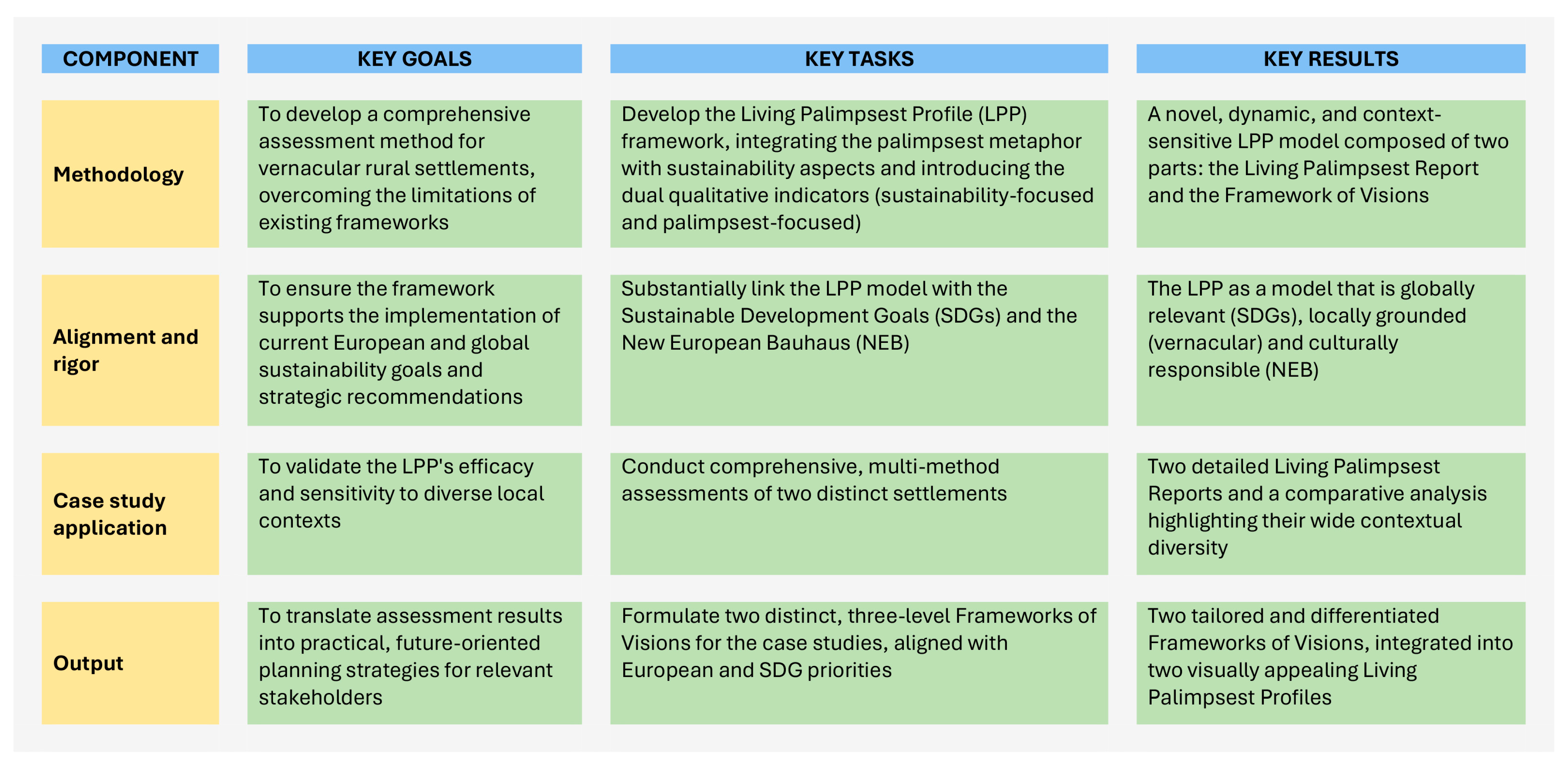
Figure 1. Development of the Living Palimpsest Profile (LPP): Key components, goals, tasks and results. (Source: Authors).
Land 14 02130 g001
Figure 2. The LPP’s methodological flaw and outcome map.
Land 14 02130 g002
Figure 3. Locations of the two case study settlements, Korogonianika and Velika Hoča. (The shapefiles used were downloaded from https://ec.europa.eu/eurostat/web/gisco/geodata (accessed on 21 October 2025) and adapted by the authors).
Land 14 02130 g003
Figure 4. Korogonianika townscape, oriented north–south, with sea views, defensive housing clusters (point 5 and 6), and Bofos’ Tower (point 3). (Source: Author E. Tousi).
Land 14 02130 g004
Figure 5. Examples of heritage and vernacular structures on the map of Velika Hoča (Source: Author M. Gvozdić).
Land 14 02130 g005
Figure 6. The Living Palimpsest Profile of Korogonianika. (Source: Authors).
Land 14 02130 g006
Figure 7. The Living Palimpsest Profile of Velika Hoča. (Source: Authors).
Land 14 02130 g007
Table 1. Proposed Vernacular & Beauty Values within the LPP.
Vernacular & Beauty ValuesPalimpsest Vernacular & Beauty
What are the settlement’s key historical characteristics?
What vernacular design principles are visible (e.g., street patterns, land use, functions, climate adaptation)?
What are the key characteristics of vernacular architecture (e.g., historical period, materials, structures, climate adaptation, unique elements, socio-cultural reflection, space organization, ornaments, etc.)?
Are there unique natural assets (e.g., relief elements, landscapes, views, or endemic living species)?
Are there protected natural assets?
Is there recognized architectural heritage?
Have any vernacular architecture elements been officially recognized as heritage?
Are there other distinguishing landmarks, aside from recognized heritage and vernacular structures, that contribute to the settlement’s distinctiveness?
Are there regulations that protect tangible and intangible vernacular/heritage values?
What are the defining characteristics of vernacular practices and knowledge in the community (e.g., in linguistics, arts and crafts, agriculture, and medicine)?
Does the community recognize, value and utilize the vernacular beauty of their settlement in a responsible manner? What do the residents value/utilize the most?
Are there cultural institutions in the settlement?
Are historical layers visible and legible? Are these layers well-documented and safeguarded? Are there signs that these layers are being discontinued/lost?
Is the settlement’s vernacular character legible and dominant, or has it been partially or completely overwritten?
Are vernacular architectural layers actively maintained and used, or are they decaying, leaving only traces?
Have past interventions aimed to preserve/restore the original values or have they added a new, potentially conflicting layer?
Have any spatial interventions erased or overwritten the original vernacular text?
Are there any ongoing interventions to preserve vernacular and heritage values? Are these interventions in line with principles of ecological sustainability, circularity, and climate resilience?
Is the intangible text of vernacular knowledge and practices still actively read and written, or has it become a faded, (un)documented layer of the past?
Are young people involved in vernacular practices?
How does heritage recognition affect the creation of new layers?
Are the non-recognized physical traces from different historical periods being preserved?
Are local cultural institutions dedicated to vernacular values?
Do residents read and understand the different historical layers? Do they value the continuity or prioritize the creation of a new, separate text?
Are there any historical vernacular practices, knowledge, or physical assets that are no longer present? If so, what are they, and what caused their disappearance?
Table 2. Proposed Environment-, Infrastructure- and Ecology-related indicators within the LPP.
Environment, Infrastructure and EcologyPalimpsest of Environment, Infrastructure, and Ecology
Is the settlement easily accessible via road network and public transportation?
What is the general state of the infrastructure (fresh water supply, energy supply, sewerage system, waste management, road network, digital technology, etc.)?
Is the settlement considered a safe place to live?
What is the intensity of traffic? Are there adequate signs and signals, and traffic calming measures?
Is the settlement walkable (are pedestrian paths connected?) and bikeable? Are these sustainable mobility qualities fully utilized by the community?
Are there sources of pollution (e.g., noise, light, heat generation, industrial facilities, landfills, agricultural activities)?
Is the area rich in biodiversity, and is there a plan for its preservation?
Are there plans for sustainable maintenance and development of the settlement?
Is land use managed in an environmentally and socially responsible manner? Does new construction contribute to densification or dispersion?
Is settlement resilient to the impacts of climate change?
Is arable land impacted by climate change?
What is the intensity of new construction, and are there regulations governing it?
What are the key characteristics of modern buildings?
Does new construction adhere to the principles of ecological sustainability (including energy efficiency), circularity, and climate resilience?
Does new construction respect the natural qualities of the settlement? Is there a clear integration between the newly built and the natural environment?
Does the settlement meet community needs? What types of spatial amenities are available?
Does the settlement have central zone and/or main street?
Are there mix use spaces?
Are public and private common spaces (e.g., parks, playgrounds, clubs) being developed to foster community connection and interaction?
Do all residents have fair access to essential services such as healthcare, education, and social support? What is the condition of these services?
Is the settlement comfortable and accommodating for all generations of residents?
Do residents care about environmental and circularity aspects (e.g., recycling, disposal of hazardous waste, construction waste management, agricultural waste, use of pesticides, energy savings, etc.)? Do they actively participate in settlement maintenance?
Is there an organic farming?
Is there a system for shared decision-making regarding the settlement’s development? Are these participatory processes transparent and inclusive?
What is the share of green space in public areas? Are common green spaces easily accessible to all residents?
What types of land are present in the settlement territory?
How are the energy and water being utilized in agricultural activities?
Are chemicals used in agricultural production?
Are there local environmental regulations?
What are the average lot size and organization?
Is there any level of local self-sufficiency in terms of basic resources: water, food, or energy?
How do new transportation networks interact with the original pathways and access points? Do new layers preserve or overwrite historical circulation patterns?
How does modern infrastructure (e.g., internet cables, new water systems) interact with older systems (e.g., public wells)? Are the older layers still visible and functional, or have they been erased?
How do the historical and modern layers of a settlement—both social and physical—interact to create a sense of safety and security?
Do new industrial or technological layers harm the historical and natural environment?
How do new developments impact biodiversity?
Are there efforts to preserve original ecological integrity? Did any native living species disappear?
What are historical climate threats?
Do development plans ensure that new layers maintain the integrity of the historical environmental and social fabric?
What land use changes were occurring in the past?
How does current land use respect the area’s historical use and environmental characteristics? Do historical land-use patterns still exist, or have they been replaced?
Do the settlement’s construction layers—both old and new—work together to make the community resilient to climate change, or do new developments undermine the resilience built into older, traditional structures?
What is the intensity of new construction on the settlement’s palimpsest?
Are there regulations to ensure that new writing is legible and does not completely erase the historical text? Are there regulations that embed heritage and vernacular values and principles into the new construction (e.g., in terms distancing, materials, height, shape, openings, colors, texture, or decorative elements)?
How does new aesthetics relate to traditional style—as a modern interpretation, a stark contrast, or an attempt to mimic the past?
How do new developments and new modes of land use interact with the historical natural landscape?
How do modern amenities and spatial layouts meet residents’ needs while preserving or building upon traditional gathering places and the community structures?
How have different historical layers shaped what is now the central zone and/or main street?
Are new common spaces being developed, and if so, do they build on a historical tradition of shared spaces? Are traditional gathering places (like an old square) still vital for social interaction?
How do modern services layer upon or overwrite historical services (e.g., old schools, local shops)?
Do new layers of development and infrastructure serve all generations, or are they creating a divide between older residents who identify with the past and younger residents who are part of the new identity?
Do residents take an active role in maintaining different settlement layers, from preserving historical buildings to caring for the natural environment?
Are new layers introduced through a collective, transparent, and inclusive process? Do all residents have a voice in settlement’s future?
Did the size of the lot change over time? Does the lot organization preserve traditional rural character?
How was resource self-sufficiency managed in the past?
Table 3. Proposed Social Dynamics indicators within the LPP.
Social DynamicsSocial Palimpsest
What are the key demographic trends, such as population growth or decline, and changes in demographic structure?
What is the general educational profile?
Is there an influx of new residents into the settlement?
Is there a program to bring back the residents who left the settlement?
Is there a visible pattern of collective community behavior and identity?
Are there joint activities and events taking place? How do the residents get informed about those?
What are the key sources of attachment and pride that residents feel for their settlement?
How frequently do different generations or social groups interact? What are the primary modes of this interaction?
Are there local associations, clubs, or organizations that are active in the community?
Are there signs of social segregation, gentrification, or ghettoization that indicate a breakdown in social equity?
Is there a fair access to the agricultural land?
How do the public spaces facilitate social dynamics? Are these spaces inclusive and accessible to all groups? Do they foster a sense of collective identity and ownership? How do they manage potential conflicts between various users?
To what extent is the community open and welcoming to new residents?
To what extent is the community open to novel ideas, initiatives or experiments?
How did historical demographic trends influence the settlement’s evolution?
How do current demographic trends affect the continuity of the traditional social fabric?
Do new residents integrate into the existing community, or do they form a new, separate layer?
Does the pattern of collective community behavior reflect the settlement’s historical identity? Are joint activities and events held in traditional places?
Are there new social practices and events? If so, do they build upon or replace older traditions?
Are people primarily attached to the settlement historical core, its natural environment, or its modern layers?
Do social interactions help preserve traditional shared values, or do they highlight a divide between old and new?
Are the historical roles of local groups still visible, or have they been supplanted by new ones?
Do new and old community organizations operate independently, or do they share resources and members? Do older organizations influence how new groups function?
Have any traditional associations disappeared? If so, what were the effects on the community’s structure?
Have any old organizations been revived from community desire to reconnect with past?
Do social divisions reflect or create new layers that are separate from the community’s historical structure?
To what extent do public spaces reveal a palimpsest of social dynamics? How does the historical and cultural layers of these spaces influence social interaction?
Has any traditional social practice disappeared?
Table 4. Proposed indicators to evaluate the Local Economy within the LPP.
Local EconomyEconomic Palimpsest
What are the primary sources of income and economic activity in the community?
Is the local economy experiencing growth, stagnation or decline?
What are the key local economic resources (e.g., natural, human, or cultural)?
Are there visible signs of economic fragmentation?
Is the settlement economically self-sustainable in the long term?
Is there a balance between public and private resources? Is there a diversity of ownership and investment models? Is there a problem with land concentration?
Does the local economy’s sustainability rely on external support or subsidies?
Are the values of the settlement actively promoted?
Is the settlement attractive to visitors?
Is there a tourism industry? What types of tourism are practiced (e.g., agritourism, religious tourism, etc.)?
What is the capacity of local accommodation and other tourism infrastructure?
What is the nature of local food production, including any certified products? Where are these products marketed?
What is the nature of the local job market, and what job opportunities are available?
What is the employment rate within the local population, and in which sectors are most people employed?
Are there any tax incentives or relief programs for starting a new business?
What is the level of entrepreneurship within community?
What are the key local historical economies?
Did any traditional economic activity disappear?
Is a traditional economy (e.g., farming, crafts) still active, or has a modern one (e.g., tourism, services) replaced it?
Is the new economy building, isolating or eroding the old one (e.g., new businesses replacing old ones)?
How do existing economic resources reflect historical activities?
Are older resources being repurposed or abandoned?
Is the long-term economic sustainability based on a single, dominant model or on the coexistence of multiple economic layers (e.g., traditional agriculture alongside modern tourism)?
Is there a diversity of ownership models that reflects both traditional and modern economic layers? Do new investments and private resources work in harmony with older, public ones?
Is there a balance between historical economic foundation and externally supported economic layers?
Does settlement promotion focus on old or new layers, or a combination of both?
Which layers attract the most visitors?
Does tourism authentically represent vernacular values and heritage, or does it create a new layer?
Are there economic programs to encourage investment in historic renovations?
Disclaimer/Publisher’s Note: The statements, opinions and data contained in all publications are solely those of the individual author(s) and contributor(s) and not of MDPI and/or the editor(s). MDPI and/or the editor(s) disclaim responsibility for any injury to people or property resulting from any ideas, methods, instructions or products referred to in the content.