Exploring the Spatial Coupling Between Visual and Ecological Sensitivity: A Cross-Modal Approach Using Deep Learning in Tianjin’s Central Urban Area
Abstract
1. Introduction
2. Materials and Methods
2.1. Study Area
2.2. Data Sources
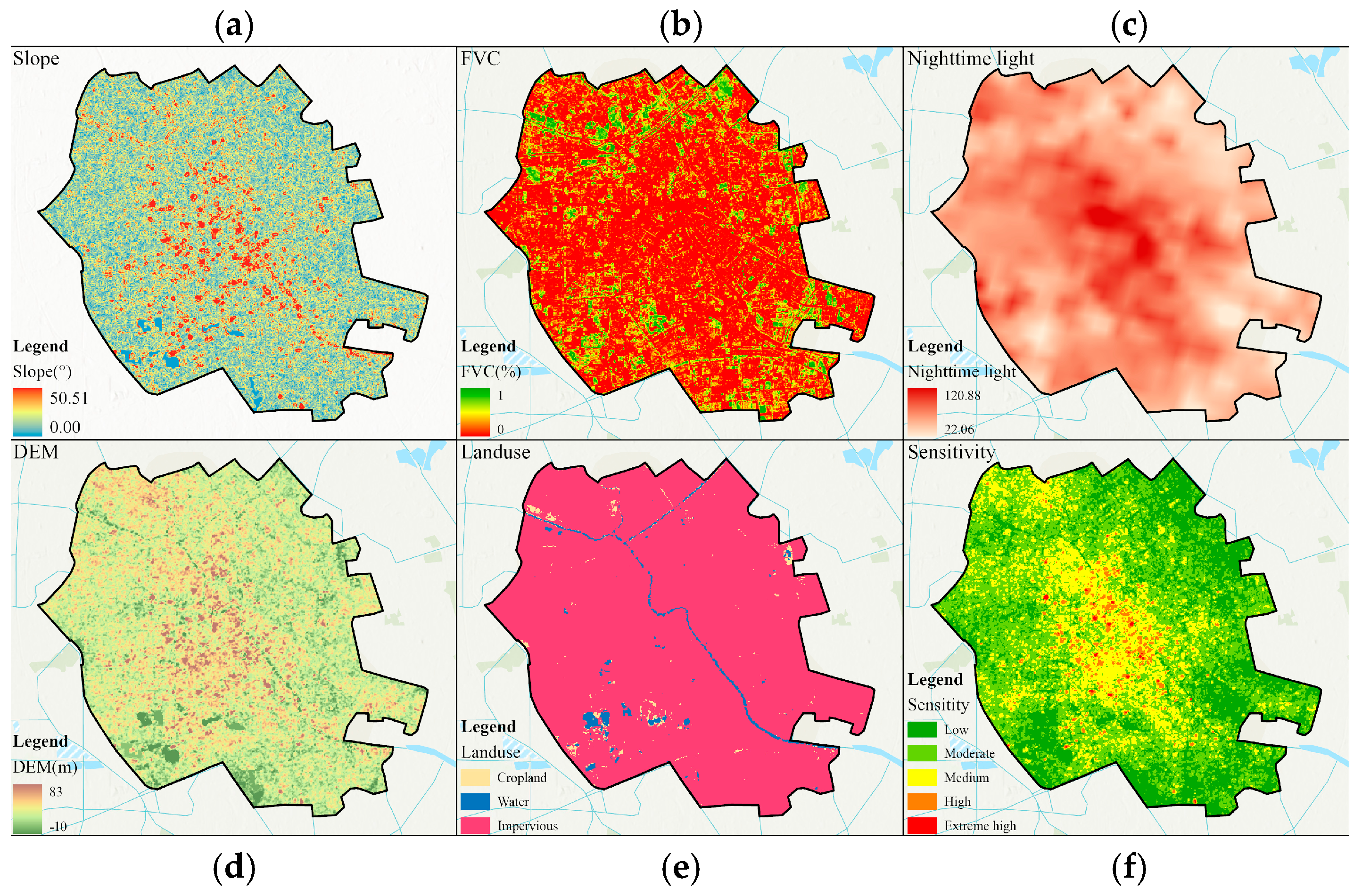
2.2.1. Traditional Ecological Sensitivity Data
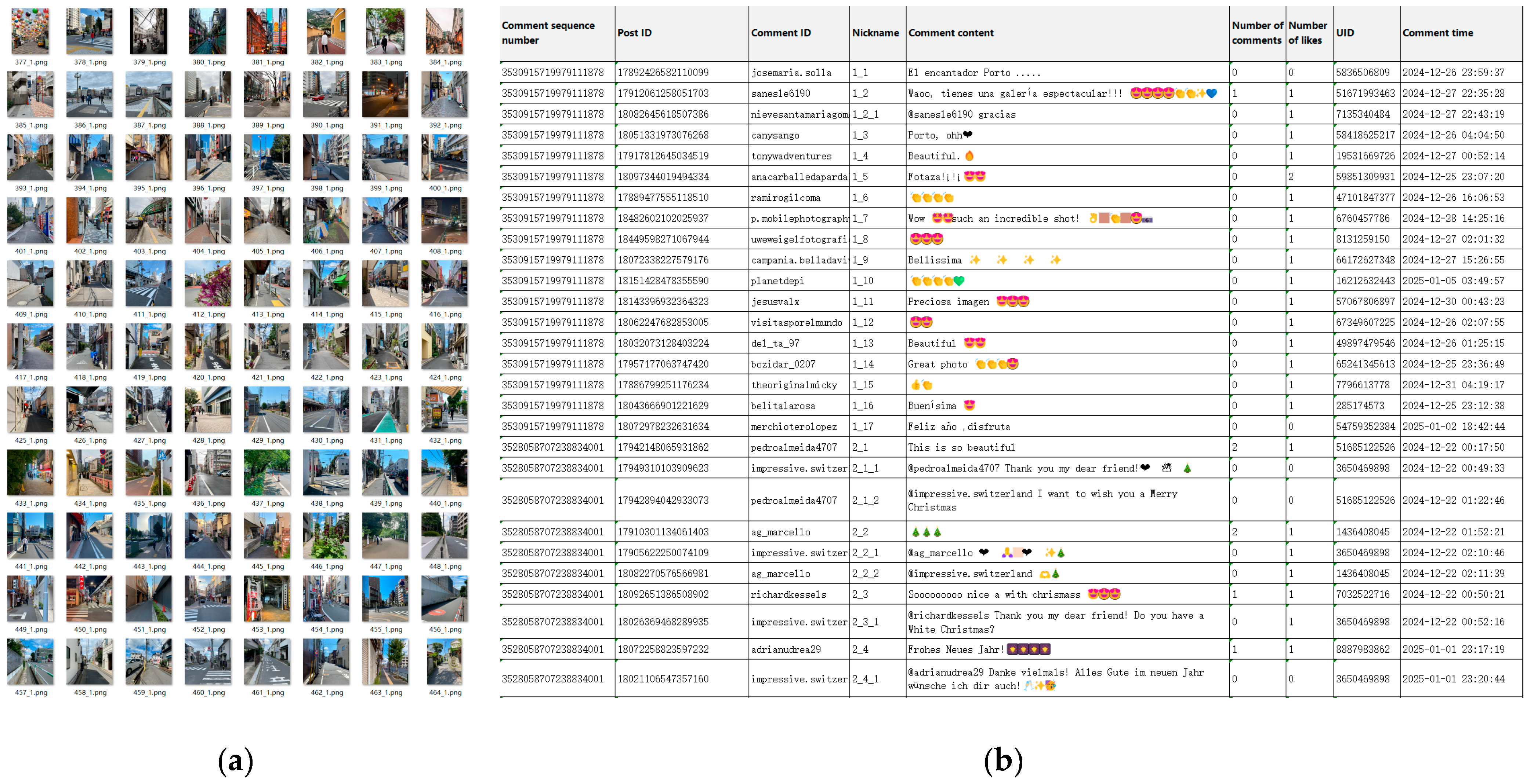
2.2.2. Social Media Data Collection
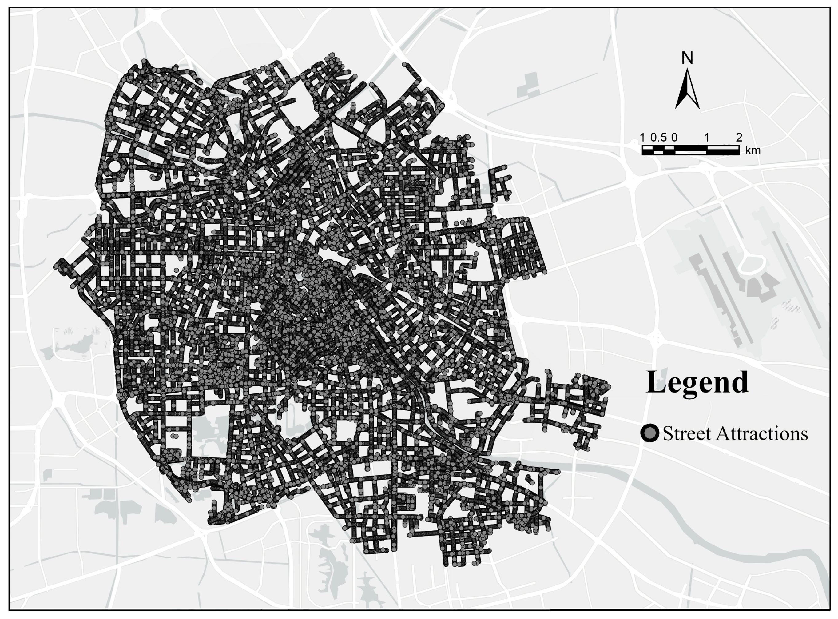
2.2.3. Baidu Street View Data Collection
2.3. Methods
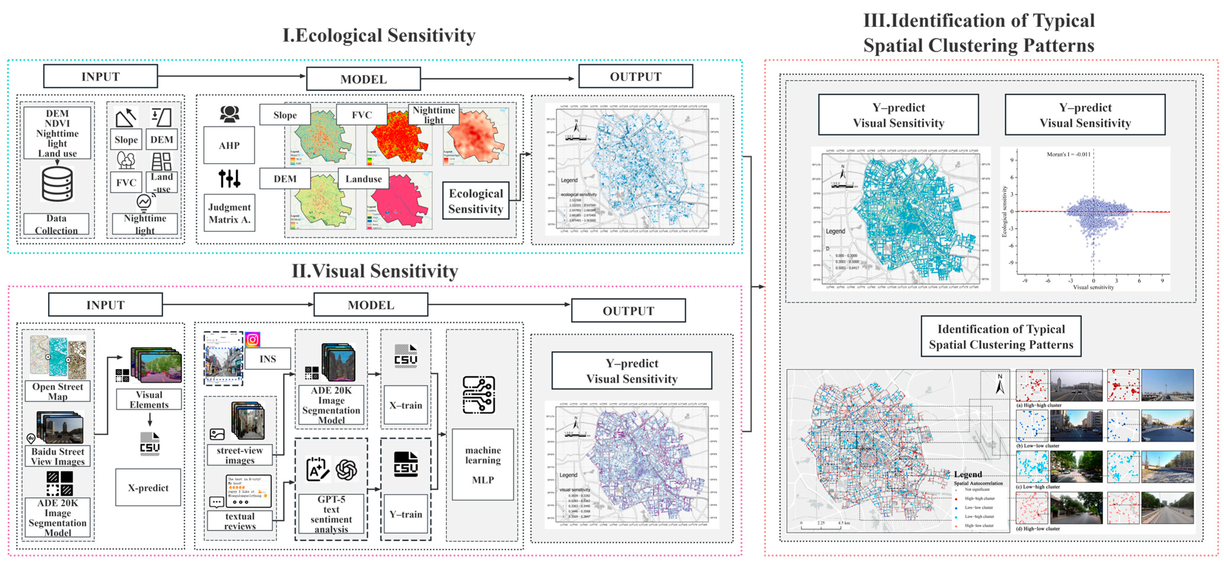
2.3.1. Research Framework
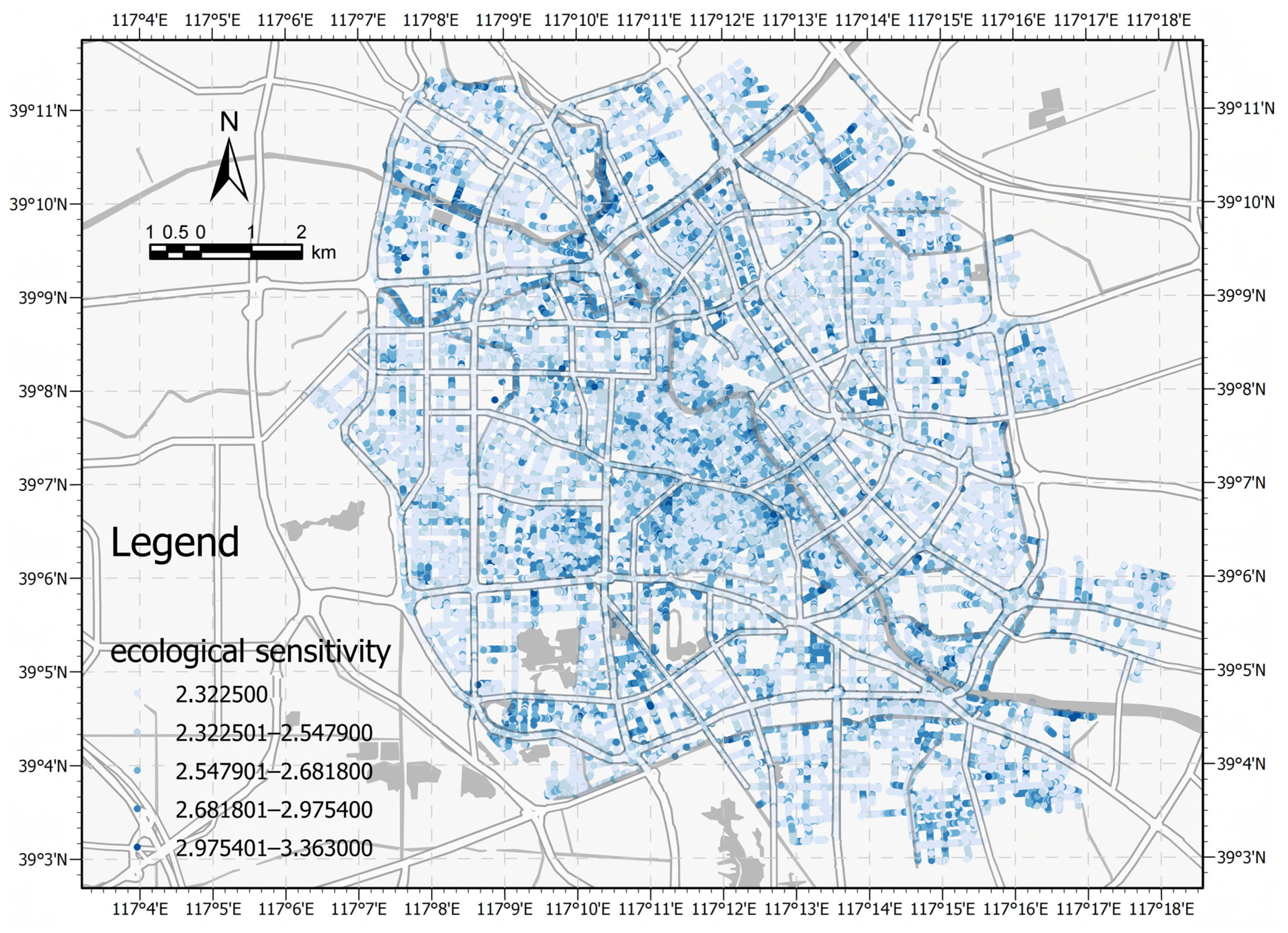
2.3.2. Ecological Sensitivity Model Construction
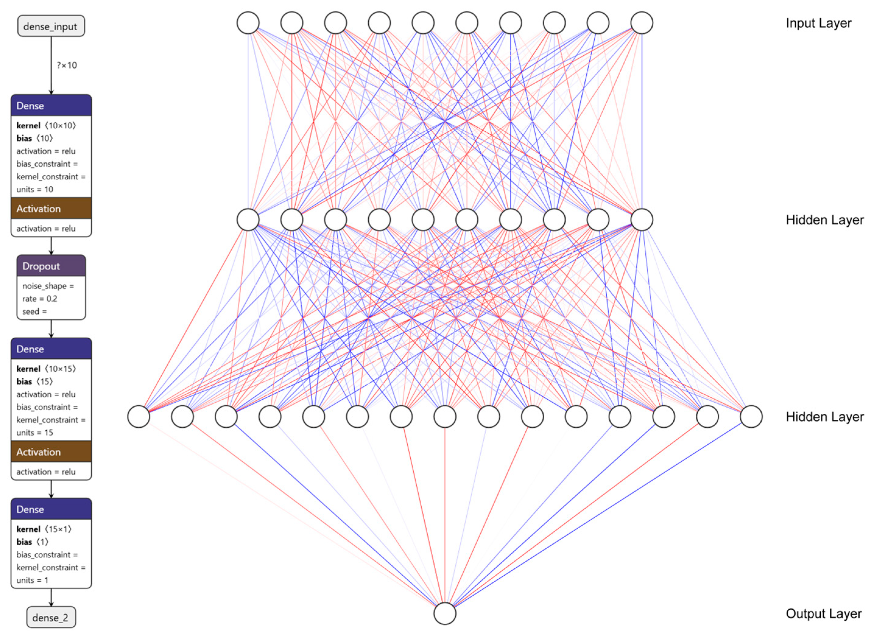
2.3.3. Construction of the Visual Sensitivity MLP Model
2.3.4. Correlation and Coupling Coordination Degree Analysis
3. Results
3.1. Results Correlation Between Landscape Features and Visual Sensitivity
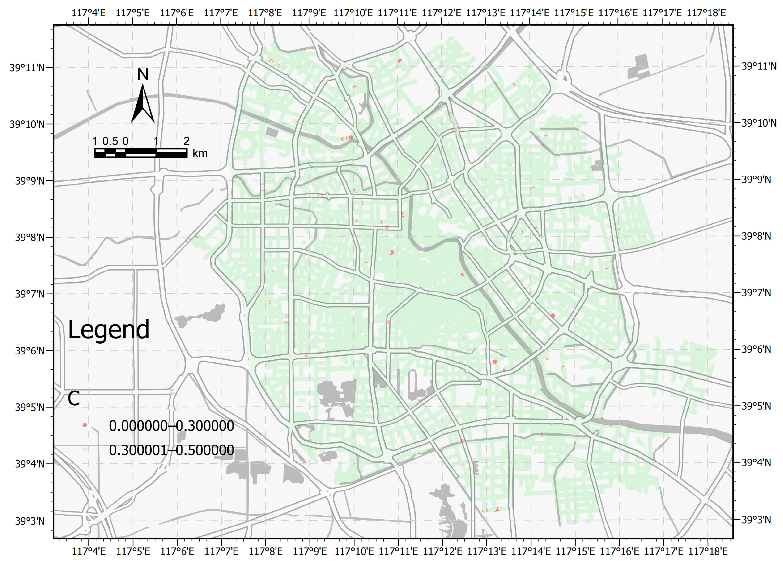
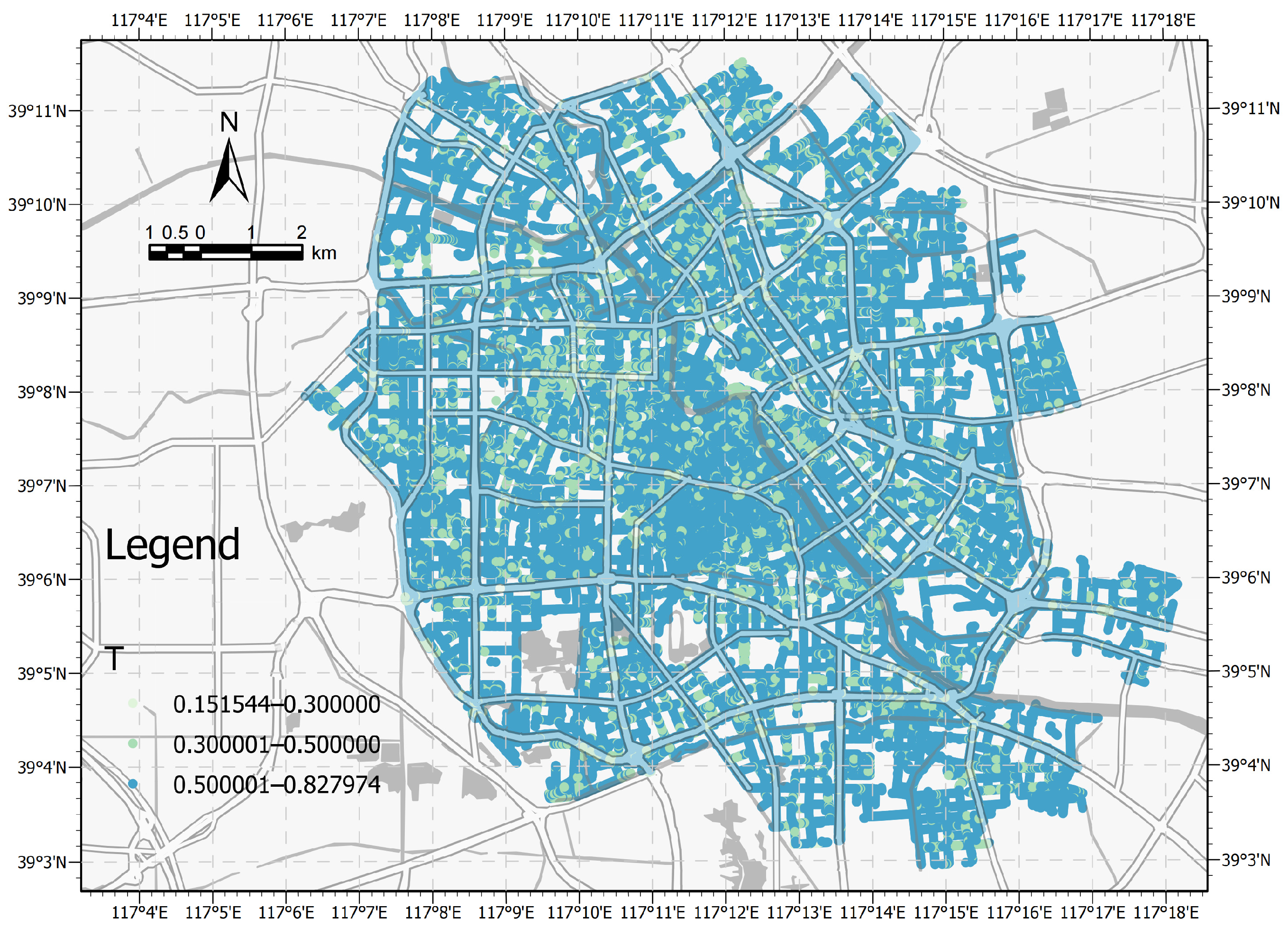
3.2. Comparative Results of Ecological and Visual Sensitivity
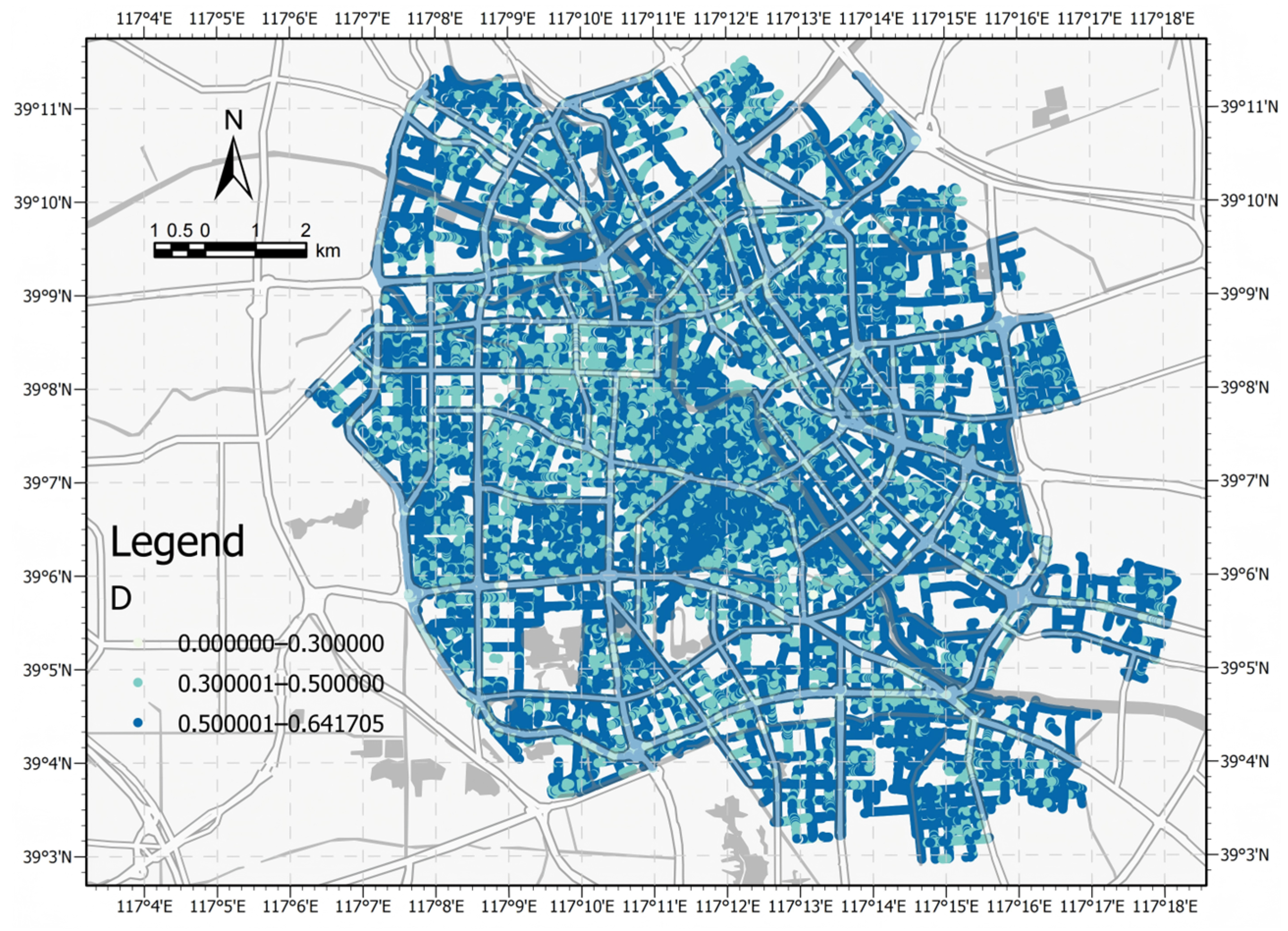
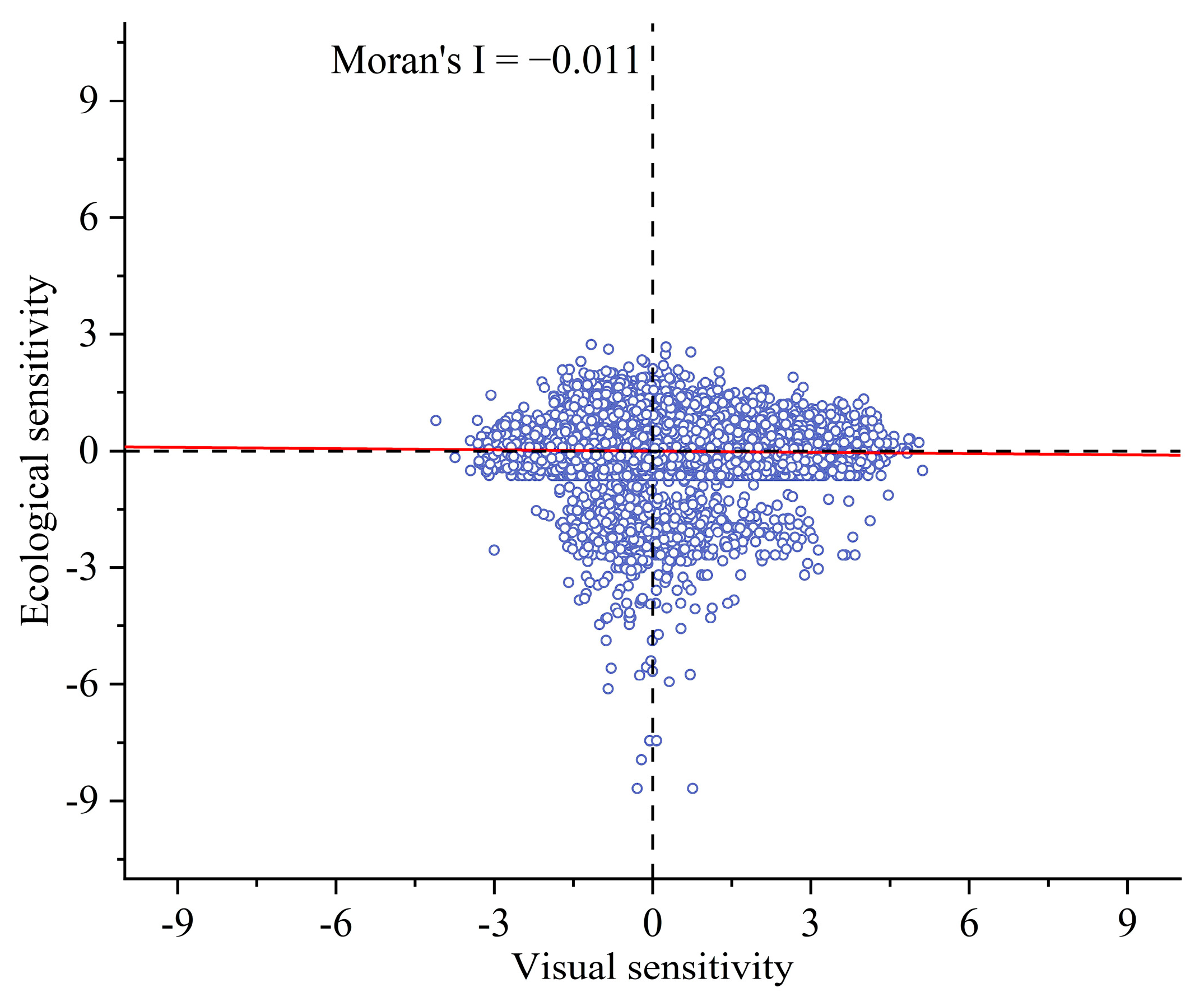
3.3. Coupling Coordination and Spatial Autocorrelation
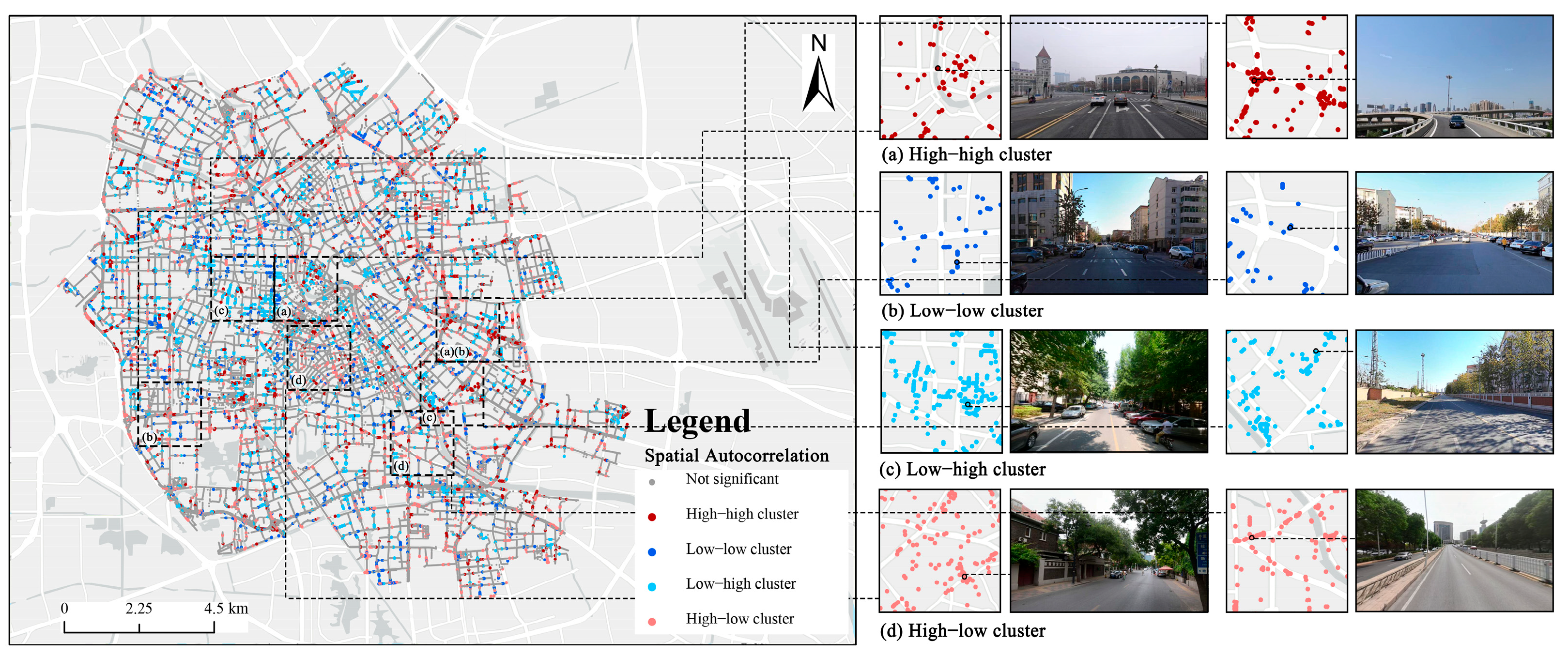
3.4. Spatial Clustering Patterns of Visual–Ecological Sensitivity
4. Discussion
4.1. Drivers of Landscape–Visual Sensitivity Correlation
4.2. Interactions Between Ecological and Visual Sensitivity
4.3. Correlation Coordination Patterns and Spatial Correlation Mechanisms
4.4. Perceptual–Ecological Mismatch and Planning Implications
4.5. Limitations
5. Conclusions
Author Contributions
Funding
Data Availability Statement
Conflicts of Interest
References
- Serra Bellini, L.; Spanò, A.; Cittadini Bellini, M.; Giulio Tonolo, F. A heterogenous-source geoinformation system to manage climate-induced modifications on the landscape for sustainable development. Discov. Sustain. 2024, 5, 297. [Google Scholar] [CrossRef]
- Peng, J.; Zhao, S.; Dong, J.; Liu, Y.; Meersmans, J.; Li, H.; Wu, J. Applying Ant Colony Algorithm to Identify Ecological Security Patterns in Megacities. Environ. Model. Softw. 2019, 117, 214–222. [Google Scholar] [CrossRef]
- Makler-Pick, V.; Gal, G.; Gorfine, M.; Hipsey, M.R.; Carmel, Y. Sensitivity Analysis for Complex Ecological Models—A New Approach. Environ. Model. Softw. 2011, 26, 124–134. [Google Scholar] [CrossRef]
- Bayraktarov, E.; Low-Choy, S.; Singh, A.R.; Beaumont, L.J.; Williams, K.J.; Baumgartner, J.B.; Laffan, S.W.; Vasco, D.; Cosgrove, R.; Wraith, J.; et al. EcoCommons Australia Virtual Laboratories with Cloud Computing: Meeting Diverse User Needs for Ecological Modeling and Decision-Making. Environ. Model. Softw. 2025, 183, 106255. [Google Scholar] [CrossRef]
- Cai, B.; Shao, Z.; Fang, S.; Huang, X.; Huq, M.E.; Tang, Y.; Li, Y.; Zhuang, Q. Finer-Scale Spatiotemporal Coupling Coordination Model between Socioeconomic Activity and Eco-Environment: A Case Study of Beijing, China. Ecol. Indic. 2021, 131, 108165. [Google Scholar] [CrossRef]
- Mingwu, Z.; Haijiang, J.; Desuo, C.; Chunbo, J. The Comparative Study on the Ecological Sensitivity Analysis in Huixian Karst Wetland, China. Procedia Environ. Sci. 2010, 2, 386–398. [Google Scholar] [CrossRef]
- Kang, J.; Dong, W.; Liu, T.; Fang, L. Exploring Ecosystem Sensitivity Patterns in China: A Quantitative Analysis Using the Importance-Vulnerability-Sensitivity Framework and Neighborhood Effects Method. Ecol. Indic. 2024, 167, 112623. [Google Scholar] [CrossRef]
- Xu, Y.; Liu, R.; Xue, C.; Xia, Z. Ecological Sensitivity Evaluation and Explanatory Power Analysis of the Giant Panda National Park in China. Ecol. Indic. 2023, 146, 109792. [Google Scholar] [CrossRef]
- Bai, Y.; Guo, R. The Construction of Green Infrastructure Network in the Perspectives of Ecosystem Services and Ecological Sensitivity: The Case of Harbin, China. Glob. Ecol. Conserv. 2021, 27, e01534. [Google Scholar] [CrossRef]
- Sahraoui, Y.; Clauzel, C.; Foltête, J.-C. A Metrics-Based Approach for Modeling Covariation of Visual and Ecological Landscape Qualities. Ecol. Indic. 2021, 123, 107331. [Google Scholar] [CrossRef]
- Zheng, Y.; Lan, S.; Chen, W.Y.; Chen, X.; Xu, X.; Chen, Y.; Dong, J. Visual Sensitivity versus Ecological Sensitivity: An Application of GIS in Urban Forest Park Planning. Urban For. Urban Green. 2019, 41, 139–149. [Google Scholar] [CrossRef]
- Qi, T.; Zhang, G.; Wang, Y.; Liu, C.; Li, X. Research on Landscape Quality of Country Parks in Beijing as Based on Visual and Audible Senses. Urban For. Urban Green. 2017, 26, 124–138. [Google Scholar] [CrossRef]
- Gobster, P.H.; Ribe, R.G.; Palmer, J.F. Themes and Trends in Visual Assessment Research: Introduction to the Landscape and Urban Planning Special Collection on the Visual Assessment of Landscapes. Landsc. Urban Plan. 2019, 191, 103635. [Google Scholar] [CrossRef]
- Bubalo, M.; van Zanten, B.T.; Verburg, P.H. Crowdsourcing Geo-Information on Landscape Perceptions and Preferences: A Review. Landsc. Urban Plan. 2019, 184, 101–111. [Google Scholar] [CrossRef]
- Huang, W.; Zhao, X.; Lin, G.; Wang, Z.; Chen, M. How to Quantify Multidimensional Perception of Urban Parks? Integrating Deep Learning-Based Social Media Data Analysis with Questionnaire Survey Methods. Urban For. Urban Green. 2025, 107, 128754. [Google Scholar] [CrossRef]
- Guo, C.; Yang, Y. A Multi-Modal Social Media Data Analysis Framework: Exploring the Complex Relationships among Urban Environment, Public Activity, and Public Perception—A Case Study of Xi’an, China. Ecol. Indic. 2025, 171, 113118. [Google Scholar] [CrossRef]
- Dunkel, A. Visualizing the Perceived Environment Using Crowdsourced Photo Geodata. Landsc. Urban Plan. 2015, 142, 173–186. [Google Scholar] [CrossRef]
- Zhang, S.; Zhou, W. Recreational Visits to Urban Parks and Factors Affecting Park Visits: Evidence from Geotagged Social Media Data. Landsc. Urban Plan. 2018, 180, 27–35. [Google Scholar] [CrossRef]
- Song, X.P.; Richards, D.R.; He, P.; Tan, P.Y. Does Geo-Located Social Media Reflect the Visit Frequency of Urban Parks? A City-Wide Analysis Using the Count and Content of Photographs. Landsc. Urban Plan. 2020, 203, 103908. [Google Scholar] [CrossRef]
- Donahue, M.L.; Keeler, B.L.; Wood, S.A.; Fisher, D.M.; Hamstead, Z.A.; McPhearson, T. Using Social Media to Understand Drivers of Urban Park Visitation in the Twin Cities, MN. Landsc. Urban Plan. 2018, 175, 1–10. [Google Scholar] [CrossRef]
- Sessions, C.; Wood, S.A.; Rabotyagov, S.; Fisher, D.M. Measuring Recreational Visitation at U.S. National Parks with Crowd-Sourced Photographs. J. Environ. Manag. 2016, 183, 703–711. [Google Scholar] [CrossRef] [PubMed]
- Gifford, R.; Ng, C.F. The relative contribution of visual and auditory cues to environmental perception. J. Environ. Psychol. 1982, 2, 275–284. [Google Scholar] [CrossRef]
- Han, T.; Tang, L.; Liu, J.; Jiang, S.; Yan, J. The Influence of Multi-Sensory Perception on Public Activity in Urban Street Spaces: An Empirical Study Grounded in Landsenses Ecology. Land 2025, 14, 50. [Google Scholar] [CrossRef]
- Peng, Y.; Li, Z.; Shah, A.M.; Lv, B.; Liu, S.; Liu, Y.; Li, X.; Song, H.; Chen, Q. Decoding the Role of Urban Green Space Morphology in Shaping Visual Perception: A Park-Based Study. Land 2025, 14, 495. [Google Scholar] [CrossRef]
- Ito, K.; Kang, Y.; Zhang, Y.; Zhang, F.; Biljecki, F. Understanding urban perception with visual data: A systematic review. Cities 2024, 152, 105169. [Google Scholar] [CrossRef]
- Tang, F.; Zeng, P.; Wang, L.; Zhang, L.; Xu, W. Urban Perception Evaluation and Street Refinement Governance Supported by Street View Visual Elements Analysis. Remote Sens. 2024, 16, 3661. [Google Scholar] [CrossRef]
- Li, Z.; Hu, L.; Lin, A.; Chen, J.; Xu, Y. The greener, the richer, the happier?—Spatial distribution and coupling analysis of urban green space and residents’ emotion based on social media data. Ecol. Indic. 2025, 177, 113754. [Google Scholar] [CrossRef]
- Guo, Y.; Su, J.G.; Dong, Y.; Wolch, J. Application of land use regression techniques for urban greening: An analysis of Tianjin, China. Urban For. Urban Green. 2019, 38, 11–21. [Google Scholar] [CrossRef]
- Wu, Y.; Shi, K.; Chen, Z.; Liu, S.; Chang, Z. Developing improved time-series DMSP-OLS-like data (1992–2019) in China by integrating DMSP-OLS and SNPP-VIIRS. IEEE Trans. Geosci. Remote Sens. 2021, 60, 1–14. [Google Scholar] [CrossRef]
- Li, Z.; Liu, J.; Ma, R.; Xie, W.; Zhao, X.; Wang, Z.; Zhang, B.; Yin, L. Construction of Ecological Security Pattern Based on Ecosystem Services, Sensitivity, Connectivity, and Resistance—A Case Study in the Huang-Huai-Hai Plain. Land 2024, 13, 2243. [Google Scholar] [CrossRef]
- Zhang, Y.; Wang, M.; Yang, X.; Zhang, R. Urban Commercial Space Vitality Evaluation Method Based on Social Media Data: The Case of Shanghai. Land 2025, 14, 697. [Google Scholar] [CrossRef]
- Huang, J.; Obracht-Prondzynska, H.; Kamrowska-Zaluska, D.; Sun, Y.; Li, L. The Image of the City on Social Media: A Comparative Study Using “Big Data” and “Small Data” Methods in the Tri-City Region in Poland. Landsc. Urban Plan. 2021, 206, 103977. [Google Scholar] [CrossRef]
- Chaudhuri, A. Visual and Text Sentiment Analysis Through Hierarchical Deep Learning Networks; Springer: New York, NY, USA, 2019. [Google Scholar]
- Cvetojevic, S.; Juhász, L.; Hochmair, H.H. Positional Accuracy of Twitter and Instagram Images in Urban Environments. GIScience 2016, 1, 191–203. [Google Scholar] [CrossRef]
- Hartman, R.; Simova, T. How changing API terms changed Instagram’s domain? A bibliometric analysis. In Proceedings of the 2021 7th International Conference on Computer Technology Applications, Vienna, Austria, 13–15 July 2021; pp. 73–79. [Google Scholar]
- Chen, Y.; Zhang, Q.; Deng, Z.; Fan, X.; Xu, Z.; Kang, X.; Pan, K.; Guo, Z. Research on Green View Index of Urban Roads Based on Street View Image Recognition: A Case Study of Changsha Downtown Areas. Sustainability 2022, 14, 16063. [Google Scholar] [CrossRef]
- Zhao, P.; Zhang, L.; Xu, M. Assessing Urban Environmental Sensitivity Using Multi-Dimensional Data: A Case Study of Beijing. Environ. Sci. Technol. 2017, 51, 4641–4649. [Google Scholar] [CrossRef]
- Li, Y.; Zhang, X. A Framework for Integrating Big Data in Urban Environmental Assessments: The Role of Social Media. Environ. Impact Assess. Rev. 2021, 81, 106388. [Google Scholar] [CrossRef]
- Miao, P.; Li, C.; Xia, B.; Zhao, X.; Wu, Y.; Zhang, C.; Wu, J.; Cheng, F.; Pu, J.; Huang, P.; et al. Incorporating Ecosystem Service Trade-Offs and Synergies with Ecological Sensitivity to Delineate Ecological Functional Zones: A Case Study in the Sichuan-Yunnan Ecological Buffer Area, China. Land 2024, 13, 1503. [Google Scholar] [CrossRef]
- Huang, Q.; Li, T. Street View Image Classification for Urban Ecological Evaluation Based on Deep Learning Techniques. Remote Sens. Environ. 2019, 234, 111417. [Google Scholar] [CrossRef]
- Luo, Q.; Bao, Y.; Wang, Z.; Chen, X.; Wei, W.; Fang, Z. Vulnerability Assessment of Urban Remnant Mountain Ecosystems Based on Ecological Sensitivity and Ecosystem Services. Ecol. Indic. 2023, 151, 110314. [Google Scholar] [CrossRef]
- Chen, Z.; Wang, H.; Liu, S. Ecological Sensitivity Evaluation and Spatial Differentiation in Urban Areas Based on Multi-Source Data. Ecol. Indic. 2020, 98, 444–455. [Google Scholar] [CrossRef]
- Hu, C.; Zhao, J.; Zhang, L. A Novel Multi-Criteria Decision-Making Model for Ecological Sensitivity Assessment in Urban Regions. Environ. Model. Softw. 2018, 101, 40–49. [Google Scholar] [CrossRef]
- Feng, H.; Zhang, X.; Nan, Y.; Zhang, D.; Sun, Y. Ecological sensitivity assessment and spatial pattern analysis of land resources in Tumen River Basin, China. Appl. Sci. 2023, 13, 4197. [Google Scholar] [CrossRef]
- Wu, D.; Wu, H.; Zhao, X.; Zhou, T.; Tang, B.; Zhao, W.; Jia, K. Evaluation of Spatiotemporal Variations of Global Fractional Vegetation Cover Based on GIMMS NDVI Data from 1982 to 2011. Remote Sens. 2014, 6, 4217–4239. [Google Scholar] [CrossRef]
- Arellano, B.; Roca, J. Identifying urban sprawl by night lights: A pending issue. Proc. SPIE 2020, 11535, 115350H. [Google Scholar] [CrossRef]
- Wang, X.; Zhu, T.; Jiang, C. Landscape ecological risk based on optimal scale and its tradeoff/synergy with human activities: A case study of the Nanjing metropolitan area, China. Ecol. Indic. 2025, 170, 113040. [Google Scholar] [CrossRef]
- Guo, T.; Xu, Z.; Zhu, L.; Zhang, Y.; Zhao, X. Sub-District Level Spatiotemporal Changes of Carbon Storage and Driving Factor Analysis: A Case Study in Beijing. Land 2025, 14, 151. [Google Scholar] [CrossRef]
- Zheng, Y.; Zhou, Q.; He, Y.; Wang, C.; Wang, X.; Wang, H. An Optimized Approach for Extracting Urban Land Based on Log-Transformed DMSP-OLS Nighttime Light, NDVI, and NDWI. Remote Sens. 2021, 13, 766. [Google Scholar] [CrossRef]
- Zheng, Y.; Tang, L.; Wang, H. An improved approach for monitoring urban built-up areas by combining NPP-VIIRS nighttime light, NDVI, NDWI, and NDBI. J. Clean. Prod. 2021, 328, 129488. [Google Scholar] [CrossRef]
- Martinez-Sanchez, L.; Hufkens, K.; Kearsley, E.; Naydenov, D.; Czúcz, B.; van de Velde, M. Semantic Segmentation Dataset of Land Use/Cover Area Frame Survey (LUCAS) Rural Landscape Street View Images. Data Brief. 2024, 54, 110394. [Google Scholar] [CrossRef]
- Inoue, T.; Manabe, R.; Murayama, A.; Koizumi, H. The effect of culture-specific differences in urban streetscapes on the inference accuracy of deep learning models. ISPRS Ann. Photogramm. Remote Sens. Spat. Inf. Sci. 2022, 10, 73–80. [Google Scholar] [CrossRef]
- Lee, D.H.; Park, H.Y.; Lee, J. A Review on Recent Deep Learning-Based Semantic Segmentation for Urban Greenness Measurement. Sensors 2024, 24, 2245. [Google Scholar] [CrossRef] [PubMed]
- Zhang, H.; Han, H.; Qiao, L.; Zhuang, J.; Ren, Z.; Su, Y.; Xia, Y. Emotional-Health-Oriented Urban Design: A Novel Collaborative Deep Learning Framework for Real-Time Landscape Assessment. Int. J. Environ. Res. Public Health 2022, 19, 13308. [Google Scholar] [CrossRef]
- Sun, H.; Xu, H.; He, H.; Wei, Q.; Yan, Y.; Chen, Z.; Li, X.; Zheng, J.; Li, T. A Spatial Analysis of Urban Streets under Deep Learning Based on Street View Imagery. Sustainability 2023, 15, 14798. [Google Scholar] [CrossRef]
- Arulananth, T.S.; Kuppusamy, P.G.; Kumar, R.; Saadat, M.A.; Mahalakshmi, M.; Vasanth, K.; Chinnasamy, P. Semantic Segmentation of Urban Environments: Leveraging U-Net Deep Learning Model for Cityscape Image Analysis. PLoS ONE 2024, 19, e0300767. [Google Scholar] [CrossRef]
- Zhang, H.; Liu, H.; Kim, C. Semantic and Instance Segmentation in Coastal Urban Spatial Perception. Sustainability 2024, 16, 833. [Google Scholar] [CrossRef]
- Hong, Q. Exploring the spatial attributes of streets in Lu Xun’s hometown of Shaoxing, China, through image semantic segmentation. J. Chin. Archit. Urban. 2024, 6, 1736. [Google Scholar] [CrossRef]
- Chen, Z.; Hao, Y. Research on Street View Information Extraction Method Based on Convolutional Neural Network. In Proceedings of the 2024 IEEE 6th International Conference on Power, Intelligent Computing and Systems (ICPICS), Shenyang, China, 26–28 July 2024; pp. 525–530. [Google Scholar]
- Suzuki, M.; Mori, J.; Maeda, T.N.; Ikeda, J. The Economic Value of Urban Landscapes in a Suburban City of Tokyo: A Semantic Segmentation Approach Using Google Street View Images. J. Asian Archit. Build. Eng. 2022, 22, 1110–1125. [Google Scholar] [CrossRef]
- Hua, C.; Lv, W. Optimizing Semantic Segmentation of Street Views with SP-UNet for Comprehensive Street Quality Evaluation. Sustainability 2025, 17, 1209. [Google Scholar] [CrossRef]
- Li, X.; Chen, Y.; Wang, J. Graph Neural Networks Optimized with Gazelle Optimization Algorithm for Urban Plantscape Design Based on Large-Scale Street View. J. Eng. Sci. 2024, 20, 3154. [Google Scholar] [CrossRef]
- Pan, S.; Li, J.; Jiang, J. A Street View Semantic Segmentation Algorithm Based on DeeplabV3+ Architecture. In Proceedings of the 3rd International Conference on Artificial Intelligence, Automation, and High-Performance Computing (AIAHPC 2023), Wuhan, China, 31 March–2 April 2023; Volume 12717. [Google Scholar] [CrossRef]
- Ma, X.; Ma, C.; Wu, C.; Xi, Y.; Yang, R.; Peng, N.; Zhang, C.; Ren, F. Measuring Human Perceptions of Streetscapes to Better Inform Urban Renewal. Cities 2021, 110, 103086. [Google Scholar] [CrossRef]
- Benesty, J.; Chen, J.; Huang, Y.; Cohen, I. Pearson correlation coefficient. In Noise Reduction in Speech Processing; Springer: Berlin/Heidelberg, Germany, 2009; pp. 1–4. [Google Scholar]
- Gong, Y.; Wang, X.; Zhang, Q.; Li, H. Correlation Analysis of Landscape Structure and Water Quality in Wetland Parks: A Case Study in Suzhou, China. Water 2021, 13, 2075. [Google Scholar] [CrossRef]


| Data | Year | Spatial Resolution | Sources |
| Land use | 2022 | 30 m | https://zenodo.org/ (accessed on 4 January 2025) |
| NDVI | 2022 | 30 m | https://www.nesdc.org.cn/ (accessed on 4 January 2025) |
| Nighttime light | 2022 | 500 m | https://dataverse.harvard.edu/dataset.xhtml?persistentId=doi:10.7910/DVN/GIYGJU (accessed on 4 January 2025) |
| DEM | 2000 | 30 m | https://www.earthdata.nasa.gov/ (accessed on 4 January 2025) |
| Ecological Sensitivity | Elevation | Slope | FVC | Land Use Types | Nighttime Light | Wi |
| Elevation | 1 | 3 | 2 | 7 | 9 | 0.4408 |
| Slope | 0.3333 | 1 | 0.25 | 4 | 5 | 0.1597 |
| FVC | 0.5 | 4 | 1 | 3 | 5 | 0.2936 |
| Land use types | 0.1429 | 0.25 | 0.3333 | 1 | 2 | 0.0657 |
| Nighttime light | 0.1111 | 0.2 | 0.2 | 0.5 | 1 | 0.0403 |
| 1 | 2 | 3 | 4 | 5 | 6 | 7 | 8 | 9 | 10 | 11 | |
| visual sensitivity (1) | 1 | ||||||||||
| Road (2) | 0.288 | 1 | |||||||||
| Building (3) | −0.806 ** | −0.053 | 1 | ||||||||
| People (4) | 0.949 ** | 0.213 | −0.728 * | 1 | |||||||
| Mountain (5) | −0.793 ** | −0.052 | 0.968 ** | −0.718 * | 1 | ||||||
| Sky (6) | 0.718 * | −0.003 | −0.973 ** | 0.645 * | −0.975 ** | 1 | |||||
| Plant (7) | −0.828 ** | −0.207 | 0.906 ** | −0.719 * | 0.845 ** | −0.862 ** | 1 | ||||
| TS (8) | −0.860 ** | −0.214 | 0.925 ** | −0.758 ** | 0.869 ** | −0.877 ** | 0.995 ** | 1 | |||
| Water (9) | −0.875 ** | −0.358 | 0.652 * | −0.808 ** | 0.654 * | −0.623 * | 0.795 ** | 0.803 ** | 1 | ||
| AB (10) | 0.730 * | 0.124 | −0.819 ** | 0.579 | −0.765 ** | 0.754 ** | −0.883 ** | −0.875 ** | −0.654 * | 1 | |
| Vehicle (11) | −0.962 ** | −0.199 | 0.904 ** | −0.915 ** | 0.900 ** | −0.848 ** | 0.867 ** | 0.897 ** | 0.796 ** | −0.787 ** | 1 |
Disclaimer/Publisher’s Note: The statements, opinions and data contained in all publications are solely those of the individual author(s) and contributor(s) and not of MDPI and/or the editor(s). MDPI and/or the editor(s) disclaim responsibility for any injury to people or property resulting from any ideas, methods, instructions or products referred to in the content. |
© 2025 by the authors. Licensee MDPI, Basel, Switzerland. This article is an open access article distributed under the terms and conditions of the Creative Commons Attribution (CC BY) license (https://creativecommons.org/licenses/by/4.0/).
Share and Cite
Kang, Z.; Xu, C.; Gu, Y.; Wu, L.; He, Z.; Heng, X.; Wang, X.; Hu, Y. Exploring the Spatial Coupling Between Visual and Ecological Sensitivity: A Cross-Modal Approach Using Deep Learning in Tianjin’s Central Urban Area. Land 2025, 14, 2104. https://doi.org/10.3390/land14112104
Kang Z, Xu C, Gu Y, Wu L, He Z, Heng X, Wang X, Hu Y. Exploring the Spatial Coupling Between Visual and Ecological Sensitivity: A Cross-Modal Approach Using Deep Learning in Tianjin’s Central Urban Area. Land. 2025; 14(11):2104. https://doi.org/10.3390/land14112104
Chicago/Turabian StyleKang, Zhihao, Chenfeng Xu, Yang Gu, Lunsai Wu, Zhiqiu He, Xiaoxu Heng, Xiaofei Wang, and Yike Hu. 2025. "Exploring the Spatial Coupling Between Visual and Ecological Sensitivity: A Cross-Modal Approach Using Deep Learning in Tianjin’s Central Urban Area" Land 14, no. 11: 2104. https://doi.org/10.3390/land14112104
APA StyleKang, Z., Xu, C., Gu, Y., Wu, L., He, Z., Heng, X., Wang, X., & Hu, Y. (2025). Exploring the Spatial Coupling Between Visual and Ecological Sensitivity: A Cross-Modal Approach Using Deep Learning in Tianjin’s Central Urban Area. Land, 14(11), 2104. https://doi.org/10.3390/land14112104


