Abstract
The social-ecological resilience of rural settlements refers to their ability to resist and mitigate the risks posed by internal and external disturbances, and to utilize the external environment to achieve a new equilibrium state. Amid rapid urbanization, it is of great significance for mountainous settlements to improve their risk resistance and development ability. Taking Dong’an Town in Chengkou County, located in the eastern part of Qinling–Bashan Mountains in southwestern China, as the research object, this study constructs an evaluation index system for rural residential resilience based on social-ecological resilience theory. It explores the resilience level of rural residences in mountainous areas from the dimensions of internal resilience and external environmental resilience and scientifically proposes an optimization path for the spatial layout of rural residences. This study provides a reference for optimizing the rural living environment, promoting spatial equity, and improving people’s livelihood according to local conditions. The results showed that: (1) The overall level of security resilience of rural settlements in Dong’an Town was relatively high, with 221 patches above the security level, accounting for 19.53% of the total area of the town. (2) The rural residents in Dong’an Town can be categorized into three types: core structure optimization, peripheral system upgrading, and relocation and withdrawal. Different types of rural settlements adapt to internal and external resource conditions and select optimal spatial layout paths according to local conditions.
1. Introduction
Rural decline has recently emerged as a global issue [1]. China’s economy and society have grown swiftly, particularly since the reform and opening up, accompanied by the world’s largest and quickest urbanization process. A vast number of resource elements have accumulated and concentrated in cities. While cities expand, the challenge of rural decline has intensified. With urban development, a large number of rural residents have moved to cities, leading to additional spatial issues such as abandoned farmland, hollow towns, and ecological degradation [2,3,4]. Sustainable rural development has become a global consensus for addressing rural decline. One of the primary objectives of the United Nations 2030 Sustainable Development Goals (SDGs) is to reduce regional development inequality. China’s rural revitalization policy is based on integrated urban–rural development and harmonious coexistence of humans and nature. Improving the resilience of rural territorial systems is a critical step toward ensuring sustainable rural development [5,6,7]. Resilience theory originated in urban studies [8,9] and refers to the ability of urban systems and regions to maintain public safety, social order, and economic development by adequately preparing for, buffering against, and responding to unknown shocks [10,11,12,13,14].
The rural settlements in mountainous regions bear complex human–land relationships, serving as both sensitive ecological zones and vulnerable socio-economic areas [2,3,15]. Amid rapid urbanization, these rural areas commonly face a paradoxical situation of continuous population outflow alongside the idle and inefficient expansion of construction land [15,16,17]. Resilience theory provides an important paradigm for analyzing the adaptive capacity of complex systems. The international academic community has undergone a profound theoretical system construction process in the theoretical research on rural resilience in mountainous areas. Early research was dominated by the concept of engineering resilience, focusing on the passive response capacity of mountainous settlements to natural disasters [18]. With the rise of sustainable development concepts, the research paradigm gradually shifted toward ecological resilience and socio-economic resilience. Some researchers have applied adaptive cycle theory to the study of rural multifunctional transitions, proposing a dynamic evolution model of “disturbance–reorganization–renewal,” providing a theoretical framework for understanding the resilience evolution of agricultural systems in the Alps [19]. Other scholars have developed a resilience assessment model encompassing institutional, economic, social, and material dimensions, applied to rural studies in the Appalachian Mountains of the United States [20,21]. In addition, some studies demonstrated through multi-agent modeling that rural areas in the Spanish Pyrenees exhibit nonlinear characteristics in system evolution under the dual pressures of population aging and climate change, necessitating the construction of dynamic resilience management systems by policymakers [22]. Additionally, some studies designed a resilience indicator system comprising 29 risk factors in the Italian Alps, and empirical findings indicate that social capital contributes up to 43% to the overall resilience of rural mountainous areas [23]. Social-ecological resilience theory emphasizes a system’s ability to withstand and adapt to internal and external disturbances, thereby fostering the capacity for sustainable development. This provides an important theoretical framework for analyzing the optimal development pathways of mountain communities in response to social, economic, and ecological challenges.
In recent years, several researchers have also begun to pay attention to the importance of social-ecological resilience theory in the optimization of rural settlement patterns. They have constructed theoretical frameworks and measurement systems for rural resilience, in addition to analyzing the optimization paths of clustering, protection, and relocation according to the resilience levels of appropriateness, redundancy, adaptability, and self-organization in typical case areas [24,25,26]. Evolution resilience theory considers that the system is not in a stable and balanced state, emphasizing the dynamic adaptation of the system to internal and external disturbances. According to the theory of evolution resilience, the social-ecological resilience of rural settlements refers to their ability to resist and mitigate the risks posed by internal and external disturbances, and to utilize the external environment, such as the economy, society, and the environment, to achieve a new state of equilibrium. Some studies have constructed resilience mechanisms for rural socio-economic systems based on evolutionary resilience theory [9,27,28]. Rural settlements have multiple functions, such as residence and business activities, as they are rooted in the social–economic–ecological system of the rural area, and are closely coupled with the resources, information, personnel, and other elements of the surrounding area. During development, they are influenced not only by their own internal functional structure but also inevitably affected by external environmental elements [29,30,31,32].
Reconstruction and optimization of rural settlements should not only consider the allocation of resource elements within the monolithic settlement, but also consider the coordinated relationships with the external environment and elements. In terms of the countryside, it is necessary to consider the internal and external functional structure of rural settlements, recognize the connotative characteristics of rural spatial resilience, identify the risks faced by rural settlements, and cultivate a resilient rural space that is capable of adapting to changes in external disturbances or withstand such disturbances. This allows it to effectively cope with and resolve risks and challenges, bridge existing gaps in the spatial research on rural settlements, and enhance the spatial research of rural settlements in the new era [33,34,35,36]. In summary, this paper integrates social-ecological resilience theory into the study of multi-functional transformation and multi-scale mechanisms of rural areas. Using Dong’an Town, Chengkou County, Chongqing, located in the eastern part of Qinling–Bashan Mountains in southwestern China, as a case area, both the internal structure of residential areas and the surrounding resources and environmental factors are considered. Furthermore, the resilience levels of rural settlements in mountainous areas are explored from the dimensions of residential kernel resilience and residential peripheral resilience. Meanwhile, this paper preliminarily explores the mechanisms underlying the social-ecological resilience of rural settlements and proposes an optimization path for their spatial layout based on the evaluation of comprehensive resilience levels. The results can provide a theoretical reference for optimizing the layout of residential areas according to local conditions, improving the rural living environment, promoting spatial equity, and enhancing people’s livelihood.
2. Data and Methods
2.1. Study Area
The southwestern mountainous areas are one of the three climate-sensitive regions in China, with diverse ecological types and rich vegetation types. Their ecological functions are important and unique, and they exhibit characteristics such as species diversity and habitat heterogeneity. However, they are also affected by the cutting of high mountains and deep waters, resulting in a cloudy and foggy climate, frequent geological disasters, and scattered land parcels. In addition, the region is densely populated and lacks construction land, leading to extremely prominent contradictions in land supply and demand, human land relations, and ecological protection. Rural villages in Southwest China’s mountainous areas have similar challenges, such as rural exodus and hollow decay, which are exacerbated by growing urbanization. The geographical characteristics include vulnerable ecosystems in mountainous areas, frequent poverty, insufficient public infrastructure, and farmers’ reliance on natural resources. Their volatility, unpredictability, and susceptibility are also apparent.
Chengkou County is located at the junction of the Chongqing, Sichuan, and Shaanxi provinces (municipalities), and serves as an important gateway to northern Chongqing (Figure 1). The terrain of the entire county is higher in the southeast and lower in the northwest, and it is often described as “90% mountains, 5% water, and 5% farmland.” Mountains and hills account for over 80% of the county’s total area. Chengkou County faces significant population loss and inconvenient external transportation, and its economic output and urbanization rate rank among the lowest of Chongqing’s districts and counties. The area studied, Dong’an Town, is located in the eastern part of Chengkou County at the southern foot of the Daba Mountains: east of Zhenping County, Shaanxi; south of Tucheng Town, Wuxi County; west of Gaoguan Town, Heyu Township and Houping Township, Chengkou County; and north of Pingli County, Shaanxi. The town covers an area of 396 km2, making it the largest town by land area in Chongqing Municipality. The maximum elevation difference within the town exceeds 1300 m, and the area designated for ecological protection redlines reaches 360 square kilometers, accounting for over 90% of the town’s total area. The overall terrain exhibits significant elevation fluctuations, and the town comprises nine villages and one community, with a total of 3323 households and 10,646 residents. Due to the unique topographic and geomorphic characteristics of the mountainous area, the maximum carrying capacity of construction land in Dong’an Town is approximately 300 hectares, representing only 0.78% of its total land area. This ranks Dong’an Town 19th out of the 25 townships in the county. Unlike rural settlements in plain areas or suburban areas, rural settlements in mountainous areas are more prone to external disturbances. Firstly, they have long been restricted by factors such as topography and geomorphology, and high-intensity natural disasters are more frequent. Secondly, the ecological space, agricultural production space, and rural settlement space are interlaced, with more spatial perturbations. Thirdly, based on preliminary field research, the leading industries in Dong’an Town primarily focus on rural tourism and specialty agriculture. Among these, rural tourism centers around the “Kanggu Scenic Area” and has now formed an area-wide tourism development pattern characterized by “one valley and four zones.” Specialty agriculture, on the other hand, emphasizes eco-agriculture practices such as intercropping medicinal herbs under forests, as well as specialty breeding. Notably, honey products have obtained national organic food and geographical indication certifications. In summary, influenced by ecological and environmental factors, the local industrial structure remains relatively focused and exhibits limited resilience to disasters. However, under the action of internal and external disturbances, realizing stable poverty alleviation has become a crucial issue, and improving rural resilience in poverty-stricken areas is critical. Dong’an Town, Chengkou County, Qinling–Bashan Mountains Area, along with 1090 rural settlements scattered throughout the township, is taken as the research object. These settlements are representative and typical for exploring the resilience of rural settlements in mountainous areas with high topographical constraints, a high risk of natural disasters, large areas of ecological protection, and a strong pressure to consolidate the achievements of poverty eradication.
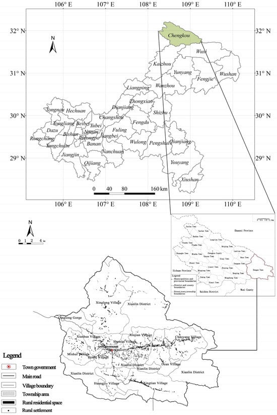
Figure 1.
Location of the study area.
2.2. Data Sources
The socio-economic data used in this paper come from the field survey and investigation interview of the research group at the end of 2020. The research group visited the district and county planning and natural resources authorities, township people’s governments, village secretaries, representatives of enterprises settled in villages, etc. Through advanced investigation methods such as unmanned aerial vehicles (UAVs) and walking site selection system, and taking the community as a unit, the research group conducted a detailed mapping of 1557 construction sites in nine villages in the whole town twice, and obtained the location, population and homestay of reception points in towns, schools, village committees and scenic spots in combination with comparative verification in the industry. The land-use data were obtained from the database of the land-use change survey in Dong’an town in 2020. Due to its unique topography and landforms, urbanization has had little impact on the town. The overall economic development mainly relies on mountain agriculture and rural tourism. Detailed analysis shows that the average annual net increase of construction land in Dong’an town was only 2.40 hectares in the past 10 years, making the 2020 data representative of the current situation. The administrative village boundary and rural residential spot boundary were extracted using ArcGIS 10.2 software. Referring to the classification standards of residential services, commercial services, public administration and public services, and industrial and mining land in the ‘Guidelines for the Classification of Land Use and Sea Use for Territorial Spatial Survey, Planning, and Use Control (Trial)’ the land within the rural settlements was subdivided, spatially segmented, attribute-numbered, and superimposed onto the attributes of the rural settlements map patches.
According to the “Spatial planning guidance to community life unit” (TD/T 1062-2021) [37], the required service radius for supporting facilities in rural community life circles is 500–1000 m or 1000 m. Taking the center of the rural settlement patches as the core point, a buffer zone with a radius of 1000 m was made to form an area that interacts with rural settlements and surrounding production, life, and ecological environment systems. Then, the area of the land-type map spot of the buffer zone can be extracted according to the space classification criteria. The land in the buffer zone is allocated to cultivated land, garden land, other agricultural land, and production space. The residential land and commercial land are allocated to living space. The nature reserve is allocated to an ecological space. Table 1 shows the list of data sources.

Table 1.
List of data sources.
2.3. Research Methods
2.3.1. Social-Ecological Resilience Connotation Characteristics of Rural Settlements
Resilience refers to the capacity of a system to return to its original state. Engineering resilience of physical systems emphasizes the speed and degree of recovery to their original steady state [38]. Ecological resilience refers to the ability of ecosystems to reach a new equilibrium state after external shocks, emphasizing their stability in terms of ecosystem structure and function [39]. Socio-ecological resilience emphasizes the ability of self-organization to enhance learning ability, adapt or change oneself to resist potential disaster risks, maintain the original balance, or form a new balance [40]. If an ecosystem in a region can restore its biodiversity through natural recovery or human intervention following pollution, this also reflects socio-ecological resilience. Rural residential land, as the spatial carrier of rural residents’ production and living activities, is a key component of the social–ecological system in rural areas. From the perspective of social–ecological system resilience, the resilience of rural settlements refers to the process of the rural settlement systems in response to the unknown risk of disturbance and impact, by enhancing the appropriateness, redundancy, and adaptability. This helps defend against and withstand external shocks, gradual restoration to the equilibrium state, and improvements to the anti-disturbance ability. Among them, suitability refers to the ability of rural residential areas to provide a better living environment, means of production, and living resources. Redundancy refers to the fact that rural residential areas have a certain level of diversity and a certain elastic space, allowing them to maintain a stable and orderly system when faced with internal and external shocks. Adaptability refers to the ability to quickly adapt to external disturbances. In contrast to previous studies that isolate rural settlements from the surrounding space and focus on the resilience characteristics of a single rural settlement, this paper embeds the resilience of rural settlements into the surrounding resource environment system based on the close interaction between rural settlements and their neighboring rural economic, social, and ecological systems, taking into account the interactions between a single rural settlement patch and its surrounding resources and environment. Taking into account the interaction between individual rural settlements and their surrounding resources and environment, the resilience of rural settlements is defined as the integrated resilience between that of the kernel system and that of the peripheral system (Figure 2). Among them, the resilience of the kernel system is assessed at the level of rural residential land parcels. It derives from the diversity of land use types, structural compatibility, and appropriate land-use intensity, enabling the system to adapt to disturbances and balance internal vulnerabilities. The resilience of the peripheral system, on the other hand, relies on a 1000-m radius buffer zone surrounding the residential areas, forming the capacity to resist external shocks and support long-term systemic development. The weighted combination of the resilience levels of these two systems constitutes the comprehensive resilience level of rural settlements.
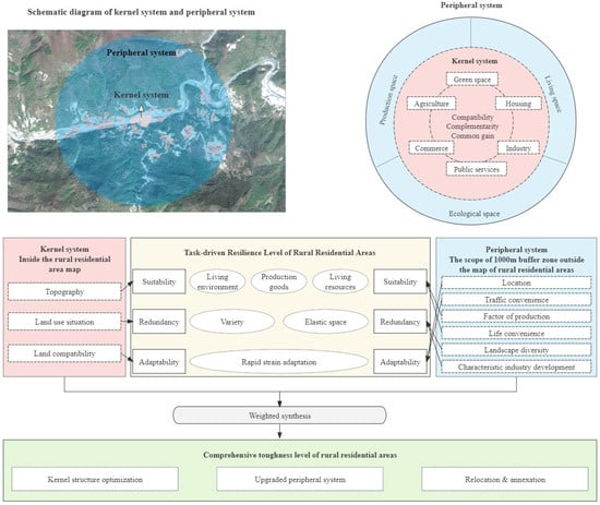
Figure 2.
Framework of social-ecological resilience level indicators for residential areas.
2.3.2. Evaluation Index System of Settlement Social-Ecological Resilience Level
(1) Constructing the evaluation index of the social-ecological resilience of the rural settlement kernel system.
Rural settlements comprise land for both production and residence, and exhibit internal structural characteristics of multiple functions such as residential, industrial, commercial, and agricultural production. If the suitability of various types of land use in rural settlements is strong, the land type structure is diverse and balanced, and the land use types are compatible with one another, the system can rapidly recover from disturbances. With reference to the multifunctional nature of rural settlements and the theory of resilience, the topographic location index (Equation (1)), the land use diversity index (Equation (2)), and the land use compatibility index (Equation (3)) are used to characterize the internal resilience of rural settlements. The topography of mountainous areas is complex, and rural settlements located in areas with lower elevations and smaller slopes have greater suitability and lower instances of natural disasters. The higher the level of diversity of land uses within the settlement, the stronger its ability to regulate its own conditions. The greater the compatibility of the various types of land within a settlement, the greater its adaptability.
The Topographic Position Index (TPI) is a versatile terrain analysis tool widely applied in fields such as geomorphology, ecology, hydrological modelling, soil erosion, archaeology, forest management, and climate change. The Land Use Diversity Index employs the Simpson’s Diversity Index, proposed by British statistician Edward Hugh Simpson in 1949. It reflects the richness and evenness of species within a community and serves as an indicator to measure the diversity of land use types in a specific area. It is commonly used to assess the complexity, balance, and multifunctionality of land use. The Land Use Compatibility Index is a quantitative tool used to evaluate the compatibility between land use and specific activities, development projects, or environmental conditions. It can be utilized to assess the coordination between different land use practices.
Topographic location index
In the above formula, T is the topographic position index, and are the elevation values of any grid in the study area and the average elevation values of all grids, respectively, and and are the slope values of any grid in the study area and the average slope values of all grids, respectively. The higher the T-value, the greater the altitude and slope of rural residential areas.
Site diversity index
In the above formula, is the land use diversity index, is the proportion of the area of land use type i to the area of rural residential land, and n is the number of land use types in rural settlements. The greater the value of , the higher the diversity of rural residential land.
Land use compatibility index
In the above formula, J is the land use compatibility index, is the compatibility value, and is the area ratio of rural residential land type i to land type j. The greater the value of , the higher the land use compatibility of rural settlements.
(2) Social-ecological resilience evaluation index of the peripheral system of residential areas.
The interactions between rural settlements and surrounding elements are reflected in several ways. First, considering the interlaced distribution of ecological space, agricultural production space, and rural settlement space in mountain settlements, which experience greater spatial disturbances, the peripheral system (which interacts closely with the settlements) should be suitable for production and life. Rural residents can make full use of the material base provided by agricultural production resources, such as cultivated land and garden land in the surrounding area, to carry out agricultural production activities, which are evaluated by indicators such as the proportion of production space, distance to the nearest school, and distance to the village committee. Considering that high-intensity natural disaster events are more frequent in the study area, the involvement of geological disaster sites is used as an index for evaluating the suitability of the peripheral system. Second, interacting with the surrounding ecological space, consuming ecological space, or disturbing the space, while utilizing the value of ecological resources, was evaluated using the distance to scenic spots and the landscape diversity index (Equation (4)). Further, considering that traditional industries—such as traditional Chinese medicine—in mountainous areas are the main source of their economy, the area of cash crop cultivation was taken as an index for evaluating the redundancy of the peripheral system. Third, social interaction with surrounding residents, as well as non-agricultural economic activities, such as the handicraft industry, rural industry, tourism, and service industry, are evaluated using the distance to the town and the density of the road network. Table 2 shows the social-ecological resilience evaluation index system for residential areas.
Table 2.
Social-ecological resilience evaluation index system for residential areas.
The Landscape Diversity Index is calculated using the Shannon Diversity Index, which was proposed by the American mathematician, engineer, and inventor Claude Shannon. It can be used to measure and evaluate the landscape characteristics of a specific area.
Landscape Diversity Index
In the above formula SHEI is the Shannon Diversity Index. is the proportion (%) of landscape type i to the total area, and is the number of patch types.
2.3.3. Standardization of the Indicator System
To eliminate the influence of the measurement unit of the evaluation indicators, the polar value method is applied to normalize the raw data.
When the indicators have a positive effect, the following formula is used:
When the indicator has a negative effect, the following formula is used:
In the above formulas, is the indicator value after normalization, and x is the original indicator value before normalization.
2.3.4. Determination of the Indicator Weights
The determination of indicator weights adopted a combination of subjective and objective methods to ensure scientific rigor and rationality. Firstly, this study preliminarily established an indicator system based on a review of the literature and calculated the objective weights of each indicator using the entropy method, applied to data from 1090 rural residential patches. To compensate for the limitations of a purely data-driven approach and incorporate multidisciplinary professional judgment, we subsequently organized an expert consultation meeting. The meeting invited 10 senior experts from various fields, including land resource management, urban and rural planning, and geography. Based on their profound disciplinary expertise and practical experience, the participating experts reviewed and discussed the initial weights derived from the entropy method. The experts’ revisions primarily focused on the following aspects: First, from a professional theoretical perspective, considering the complex topographic and geomorphological conditions of the overall study area, they suggested that the importance of the “Terrain Position Index” in the practical evaluation should be lower than indicated by data variability. Second, from a policy perspective, they recommended increasing the weight of key control factors, such as “Cash Crop Planting Area.” Third, considering local practical conditions, they clarified and optimized the definitions of certain indicators. Finally, the final weights for each indicator were determined using a weighted average method, based on a comprehensive consideration of the objective entropy weights and subjective expert opinions. This integrated process not only respected the objective patterns in the data but also incorporated multidisciplinary expertise, effectively mitigating potential biases that could arise from relying on a single method or disciplinary perspective.
2.3.5. Integration of the Kernel System and Peripheral System Resilience to Determine the Integrated Social-Ecological Resilience Level of Rural Settlements
The spatial analysis functions of ArcGIS 10.2 were used to comprehensively evaluate the social-ecological resilience results of rural settlements, and the social-ecological resilience scores of rural settlement patches were obtained. The natural breakpoint method was used to divide them into four grades: high safety, moderate safety, critical safety, and insecurity. The natural breakpoint method is based on the principles of catastrophe theory. Its fundamental approach is to cluster and categorize uncertain data by ensuring the highest possible similarity within each group while maximizing the differences between groups. This technique is particularly effective at grouping similar values together and highlighting significant distinctions between categories. It is particularly suited for identifying natural inflection points and breakpoints within datasets and is commonly used in the analysis of spatial clustering patterns [41,42].
3. Results
3.1. The Current Situation of Rural Settlements in the Study Area
Dong’an Town is located in the Qinba Mountain Area, which exhibits large altitude differences. The lowest settlement elevation is 1021 m, while the highest elevation reaches 2381 m. Approximately 75.73% of the rural residential area and 67.06% of the rural residential area were concentrated between 1100 and 1500 m above sea level (Figure 3). Above 1500 m, the number of residential areas decreased sharply. Specifically, Xianhua Village, Renhe Community, Shawan Village, Xinjian Village, Dean Village, and Chaoyang Village are closer to the township or situated along major traffic routes, with better location conditions, relatively flat terrain, and higher settlement density. Xingtian Village, located in the Kanggu Tourist Resort, also has relatively flat terrain, and the map area of the settlements is the largest, with the highest number of maps and a more centralized layout. Xinglong Village, Mishui Village, and Huangjin Village, due to their remote locations, inconvenient road traffic network, and rough terrain, have a greater concentration of settlements.
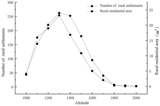
Figure 3.
Distribution of residential spots in Dong’an Town.
The internal structure of rural settlements is dominated by residential land, accounting for 58.06% of the total (Figure 4). Secondly, due to the high degree of integration between mountainous settlements and their surrounding ecological resources, the cultivated land, garden land, and other land types account for 33.25% of the total. Unlike developed areas or suburban settlements, where the internal land use structure is impacted by non-agricultural industries and the proportion of industrial and commercial land is high, the study area is located in a remote mountainous area, the level of economic development is lacking, and public services and supporting facilities are poor. Consequently, the proportion of land used for commercial service facilities, public utilities, and public administration and public service facilities is relatively low. In addition, there is no industrial land within the settlements due to the small number of secondary and tertiary industries.
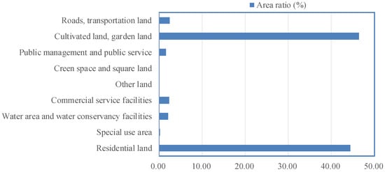
Figure 4.
Internal land use structure of residential areas in Dong’an Town.
3.2. Social-Ecological Resilience Level of Rural Settlements in the Study Area
3.2.1. Social-Ecological Resilience Level of Kernel System
The results of the evaluation of the social-ecological resilience level of the kernel system in the study area (Figure 5) show that rural residential areas with different resilience levels exhibit significant spatial differentiation characteristics. Dong’an Township has a total of 223 high-security-level rural settlement patches, with an area of 22.79 hectares, which are mainly located in areas with low elevation, good topographic conditions, and rich land use types. This reflects the significant supportive effect of superior natural conditions on the internal safety of residential areas. There are a total of 472 medium security level rural settlement patches, with an area of 58.99 hectares, whose distribution is scattered; they are mainly located in areas with medium elevation and better land use conditions. This demonstrates the adaptive layout of human activities under a certain natural carrying capacity. A total of 308 rural settlement patches are classified as having a critical security level, covering an area of 53.40 hectares. These settlements are mainly located in areas with higher elevation or poorer land-use conditions. This indicates that natural constraints are beginning to manifest and affect system resilience. Further, there are a total of 87 rural settlement maps in the insecurity level, covering an area of 32.26 hectares, which are mainly located in areas with high elevation, high slope, and other areas that are unfavorable for construction, often exhibiting a single type of land use. This reveals significant limitations of harsh natural conditions on human settlement activities. The results indicate that natural geographical conditions are the fundamental factors determining the resilient pattern of residential areas. The favorable natural conditions, including low altitude, flat terrain, and diverse land-use types, provide a stable ecological foundation and sufficient space for human settlements, supporting high system resilience. On the contrary, by limiting resource accessibility and increasing disaster risks, the sustainability of residential areas is weakened. The adaptation of human activities to natural conditions further shapes the spatial differentiation of settlement resilience. Human activities have created dispersed but resilient residential areas through moderate development. When human activities are limited by natural conditions, it will lead to increased vulnerability of residential systems.
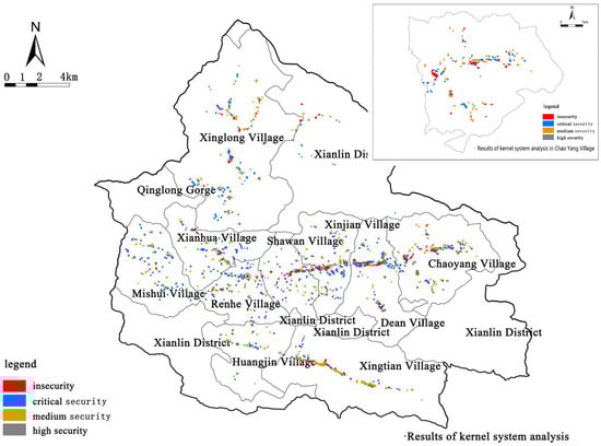
Figure 5.
Evaluation results of the social-ecological resilience level of the residential core system in Dong’an Town.
3.2.2. Social-Ecological Resilience Level of Peripheral Systems
The results of the evaluation of the social-ecological resilience level of the peripheral system in the study area (Figure 6) show that rural residential areas with different levels of resilience exhibit a circular distribution pattern centered around the town area. Dong’an Township has a total of 239 highly secure rural settlement patches, with an area of 45.74 hectares, which are mainly distributed in the periphery of the township. This reflects the crucial role of urban radiation effects in enhancing the resilience of residential areas. There are 339 moderately secure rural settlement patches, with an area of 56.45 hectares, which are mainly located in areas with relatively convenient transportation or adjacent to the tourism development industry. This indicates that infrastructure and industrial driving have a positive impact on the resilience level of residential areas. A total of 357 rural settlement patches with a critical security grade, with an area of 48.45 hectares, mainly distributed in areas far away from the town. This shows a trend of decreasing resilience of residential areas with increasing distance. Additionally, 155 low-security-level settlements were identified, covering a total area of approximately 17.12 hectares. These are primarily concentrated in Xinglong Village, Chaoyang Village, and Mishui Village. Their spatial locations share the following common characteristics: relatively high elevation, mostly situated along mountain ridges or upper slopes; significant distance from the town center, resulting in limited influence from urban radiation; and generally poor road transportation conditions, with some villages accessible only via narrow village roads, leading to low accessibility. The radiation of urban centers and the linkage between transportation and industry are the dominant factors affecting the resilience of peripheral systems. As the core of regional socio-economic activities, townships provide resilient support to surrounding residential areas through factors such as employment opportunities, public services, and market accessibility. This influence decreases with increasing distance. The development of transportation conditions and characteristic industries has effectively expanded the adaptability of the human system. In the peripheral areas of the town, the disadvantages of location and weak functions have a negative effect, leading to the vulnerability of residential areas in terms of risk response capabilities.
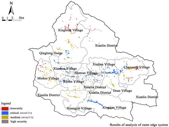
Figure 6.
Evaluation results of the social-ecological resilience level of the residential external system in Dong’an Town.
In addition, the resilience differences of residential areas at different levels are not only influenced by location and infrastructure, but also closely related to the degree of social capital accumulation and organizational level. Residential areas around the town can more effectively connect to diverse organizational networks such as government, village collectives, and enterprises. They can obtain planning guidance, resource integration, and public services, thus forming a high-resilience foundation. However, residential areas in remote areas lack effective organizational ties and external support, and their social structure is relatively loose, making it difficult to form cooperation and resource integration mechanisms. Therefore, enhancing the resilience of the peripheral system not only requires improving transportation and industrial conditions, but also emphasizes the cultivation of social organizations and network construction. Especially in peripheral areas, we should promote the establishment of grassroots self-organization, such as community cooperatives and neighborhood mutual aid groups, to enhance collective response capabilities and endogenous development momentum.
3.2.3. Comprehensive Social-Ecological Resilience Level
The results of the evaluation of the comprehensive social-ecological resilience level (Figure 7) show that the resilience level of rural residential areas in Dong’an Town exhibits a hierarchical structure of decreasing levels from the center to the periphery, accompanied by distribution characteristics extending along transportation corridors.
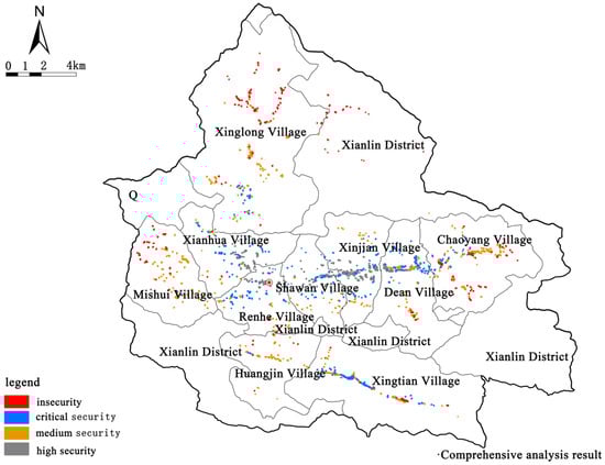
Figure 7.
Evaluation results of the comprehensive social-ecological resilience level of residential areas in Dong’an Town.
Dong’an Township has a total of 221 rural settlement patches with a high security level, covering an area of 32.70 hectares, accounting for 19.53% of the total area of rural settlements in the township, and mainly distributed in the periphery of the township. Highly secure rural settlements have good internal topography; diverse functional structures; high compatibility of land types; high external natural–social–ecological system road connectivity; diverse landscapes; good geological conditions; good conditions for the utilization of resources, such as agricultural production and tourism reception; the highest appropriateness, redundancy, and adaptability; can conveniently mobilize external resources for production and life; and can recover quickly in the face of external shocks.
Dong’an Township has a total of 292 rural settlement patches with a medium security level, covering an area of 48.58 hectares, accounting for 29.01% of the total area of rural settlements in the township. They are mainly located along the main external roads and near Xingtian Village. The suitability, redundancy, and appropriateness of the kernel and peripheral systems of the moderately safe rural settlement patches are at the intermediate level, and they have a certain adaptive ability to internal and external shocks, can adapt well to the disturbances brought by the internal and external environments, and have a certain organizational coping ability to various elements.
Dong’an Township has a total of 401 rural settlement patches with a critical safety level, covering an area of 57.57 hectares, accounting for 34.38% of the total area of rural settlements in the township. They are mainly distributed in Mishui Village, Xinglong Village, Huangjin Village, Chaoyang Village, and other areas relatively close to the township and major external roads. The suitability, redundancy, and appropriateness of the kernel and peripheral system of the critical safety residential patches are at the critical level.
There are 176 unsafe level rural settlement patches in Dong’an Township, with an area of 28.59 hectares, accounting for 17.07% of the total area of rural settlements in the township. They are mainly distributed in Xinglong Village, Mishui Village, Chaoyang Village, and Xianlin District; some of them are sporadically distributed in the fringe areas of Chaoyang Village, Dean Village, and Xingtian Village. The suitability, redundancy, and appropriateness of the system inside the rural settlements and at the periphery of the patches in the insecure level exhibit poor performance, indicating that it is difficult to effectively resist external risks and more difficult to effectively organize the recovery of the elements to adapt to internal and external disturbances.
From the perspective of spatial pattern, the resilience level of residential areas shows significant location dependence and functional agglomeration effects. On the one hand, the resilience of residential areas is influenced by the outward radiation from the central area and the guidance of infrastructure extension. This reflects the self-applicability of human activities to the geographic spatial structure through the construction of settlements and infrastructure networks. On the other hand, the degree of coupling between natural-social systems determines the foundation of residential resilience. Highly safe areas are usually located in areas with flat terrain, diverse landscapes, and stable geology. This provides sufficient ecological redundancy and adaptive capacity for human settlement activities. And the peripheral areas limit the potential for residential development.
4. Discussions and Policy Implications
4.1. Mechanistic Analysis of Social-Ecological Resilience in Rural Settlements
On the basis of the evaluation of the social-ecological resilience level of rural settlements, this paper preliminarily explores the formation mechanisms of such resilience in mountainous areas. Through a comprehensive analysis of the kernel and peripheral systems, it is found that the social-ecological resilience of rural settlements stems from the close interaction between these two systems. The kernel system primarily encompasses the land use structure, resource allocation, and spatial organization within the settlement. In contrast, the peripheral system includes infrastructure, industrial support, social resources, and other external elements that provide essential support and guarantees for the kernel system. The kernel and peripheral systems interact through multi-dimensional mechanisms such as resource flow, spatial linkage, and functional integration, ultimately shaping the comprehensive resilience of rural settlements. In this process, the coordination and balance between kernel and peripheral system factors directly influence the settlement’s resilience and adaptability.
Taking a comparative analysis of two typical rural settlements—Xingtian Village and Mishui Village—as an example, the designation of Xingtian Village as a high security rural settlement is largely attributed to its advantageous terrain and a broad spectrum of local resources (Figure 8). The village leverages rich tourism and agricultural resources, with the kernel and peripheral systems mutually reinforcing each other to form strong adaptive and restorative capacities. Especially through the joint construction and sharing of industrial projects, villagers have enhanced mutual trust and cooperation, forming a collective action ability to cope with challenges. This deep-seated social connection becomes the inherent resilience foundation for the system to cope with shocks and achieve sustainable development. Convenient transportation, a diversified industrial base, and abundant social capital enable Xingtian Village to rapidly recover and optimize its functions when faced with external disturbances. In contrast, Mishui Village exhibits a lower level of resilience due to geographic isolation, poor transportation, a single-industry structure, and a lack of external resource support. The weak coordination between its kernel and peripheral systems leads to a slower recovery from external shocks and even a tendency to fall into a negative feedback loop, thereby facing greater uncertainty and risk. This comparison highlights the significant differences in resilience performance among rural settlements under the combined influence of kernel and peripheral system factors.
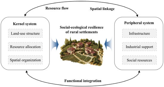
Figure 8.
Framework for the mechanism of social-ecological resilience in rural settlements.
4.2. Optimization Path of the Spatial Layout of Rural Settlements
For a long time, the spatial layout of rural settlements has lacked a scientific basis and technical support, resulting in frequent changes in spatial planning and long-term spatial conflicts. Space governance of rural settlements faces enormous challenges. Due to the scientific and practical nature of the results, the comprehensive resilience level evaluation of rural settlements can be applied to the spatial layout of rural settlements. The evaluation results of the comprehensive resilience level of rural settlements can be applied to the spatial layout of rural settlements. First of all, coupling and matching analysis was carried out using the comprehensive resilience level of residential areas and cluster grading of influence factors. The spatial layout of rural settlements is suggested to be divided into three types: kernel structure optimization, upgraded peripheral system, and relocation & annexation.
4.2.1. Kernel Structure Optimization
The overall social-ecological resilience of rural settlements at a high level of safety and severe safety is superior in terms of the location conditions, convenient external connectivity, good development prospects, and high levels of suitability, redundancy, and adaptability. Most of these settlements are located in the periphery of townships, and they have certain core driving capabilities; they will undertake some of the spillover functions of townships in the future. In terms of spatial layout optimization, full use can be made of the good location advantage, which can facilitate integration into the transportation network and public service facilities system of the township. In terms of the structural optimization arrangement, the kernel function of the settlement is focused on. In terms of industrial development, special attention should be paid to the compatibility of the functional structure of various types of land within the settlement, and the layout of low-compatibility land, such as industrial land, should be prevented from being laid out around the settlement patches. In terms of landscape transformation, it is necessary to highlight the traditional landscape features and follow the principle of protection first, followed by the overall coordination of systematic planning. For moderately safe rural settlements, it is necessary to strengthen the structural optimization of the kernel system, increase the efforts to improve the human environment around the settlement, and ensure the harmless treatment of domestic garbage and sewage, to meet the living needs of farmers by tapping into the potential of regional development.
4.2.2. Upgraded Peripheral System
For rural settlements at the critical security level, there is still much room for improvement in the level of social-ecological resilience, with particular attention required to be paid to improving the resilience of peripheral systems. This type of rural settlement needs to have a greater degree of improvement in external transportation links, infrastructure level, and industrial diversification level of farm households. A step-by-step approach needs to be adopted to synergistically combine the strengths of all parties, actively guide the participation of farmers, and realize the modernization, informatization, and environmental protection of infrastructure. Due to the dominance of a single industry, rural settlements located at the critical safety level cannot meet the diversified needs of residents’ production and life. Regional tourism resources should be actively investigated, and agriculture, culture, and tourism industries should be integrated by relying on the characteristic resources of superior villages. Further, a tourism industry chain should be created, and the regional supporting infrastructure should be enhanced to improve the employment opportunities and income levels of farmers. The tourism industry chain constructs a close community of shared interests through diverse market organizational forms such as professional cooperatives, enterprise alliances, and industry associations. This process heavily relies on the deep participation of the community. Residents not only benefit directly from industrial development through various means, such as investing in cooperatives, joining local supply chains in enterprise alliances, and participating in industry association decision-making, but also become co-builders and governance entities of the industrial chain. This organizational approach of deeply embedding communities into the industrial value chain systematically enhances internal economic connections and external risk resistance capabilities.
4.2.3. Relocation & Annexation
For rural settlements at the unsafe level, their optimization should follow the principle of encouraging rural villagers to voluntarily withdraw from their homesteads for a fee as stipulated in the Land Management Law. The main path is relocation and demolition. In specific implementation, we should prioritize the lawful recovery of long-term uninhabited and abandoned homesteads by village collectives. This should also refer to the local land acquisition compensation standards to provide reasonable compensation for the right to use homestead land and attached objects on the land. For residential areas located in ecological protection red lines and other restricted or prohibited construction areas, we should orderly relocate them through a combination of nearby resettlement, employment transfer, and policy relocation. At the same time, this should also guide residents to concentrate in areas with better transportation and resource conditions. For idle land that has been vacated, we need to reclaim it as arable land or gardens according to local land spatial planning. These reclaimed lands are used for the development of a green economy and agroforestry, and new construction activities are strictly restricted. The development of the green economy and the forest economy should be carried out in accordance with local conditions, so as to ensure that developmental and productive construction activities in relocated and demolished rural settlements are strictly controlled. In addition, employment training for relocated and dismantled rural households should also be strengthened, public welfare—with a focus on employment positions—should be set up, and the necessary social security system should be equipped. This can ensure that relocated and dismantled rural households can be stably employed and gradually obtain wealth. The key to this process is to transform the role of villagers. They should transform from passive resettlement targets to active subjects and builders of rural revitalization. They should be encouraged and supported to actively participate in local characteristic industry projects as shareholders, employees, entrepreneurs, and other multiple identities. And it should enhance their sustainable employment and self-development abilities through systematic skills training. This will truly stimulate the endogenous motivation of villagers and achieve a fundamental transformation from “passive resettlement” to “active development”.
4.3. Limitations of Applying Social-Ecological Resilience Theory to Rural Research
Resilience theory focuses on how rural settlements actively resist external shocks, recover from damage, and explore optimal paths for sustainable development under the influence of external factors, offering a new perspective for studying the optimization of rural settlement spatial layouts. Based on resilience theory, this paper evaluates the resilience level of rural settlements in Dong’an Town from the core-periphery perspective. It systematically assesses the resilience of rural settlements in Dong’an Town and proposes various layout optimization strategies based on the evaluation results. These strategies comprehensively consider the suitability of rural settlements for production and living, their compatibility with the natural environment, as well as their stability, recovery capacity, and adaptability after encountering external disturbances. The proposed spatial layout optimization strategies can guide practical efforts, thereby enhancing the resilience level of rural settlements in the study area. However, the academic community has not yet reached a consensus on the connotation and characteristics of “resilience”. The definition of “resilience” in this paper may not be sufficiently in-depth, and the research has certain limitations. Future studies can be improved in the following three aspects:
(1) Deepening the theoretical connotation of resilience and constructing a dynamic assessment system. Currently, vast rural areas in China are facing multiple pressures, including population outflow, accelerated aging, and a homogeneous industrial structure. Their social-ecological systems exhibit significant vulnerability to internal and external disturbances such as natural disasters and economic fluctuations. Against this realistic background, relying solely on static evaluation indicators can no longer accurately capture the adaptive processes of rural areas. Therefore, this study emphasizes the need to further systematically review domestic and international theoretical research, closely integrate it with the actual context of rural China, and clarify the core, typical characteristics, and key evaluation dimensions of rural settlement resilience. Particular attention should be paid to strengthening research on the dynamic interactions between the “kernel system” (e.g., built-up areas of villages) and the “peripheral system” (e.g., surrounding ecological and production spaces). This will help establish a more scientific, comprehensive resilience assessment indicator system that truly reflects the dynamic evolution of rural systems.
(2) Expand research perspectives and enhance interdisciplinary integration. The transformation of rural settlements is a complex social phenomenon influenced not only by the direct impact of population migration, such as rural-urban migration and cross-regional mobility, but also by environmental factors, including natural disasters, climate change, and resource distribution. Research on the resilience of rural settlements spans multiple academic disciplines such as geography, ecology, sociology, and economics. The characteristic of the socio-economic system is feedback, which occurs between human values, perceptions, and behaviors and the biophysical components of the ecosystem. This may lead to a decrease in resilience and ultimately lead to the collapse of sustainability. In addition, the frequency and intensity of extreme weather and climate events have increased, causing a widespread impact on rural ecosystems, humans, habitats, and infrastructure. The theory of social-ecological resilience emphasizes addressing these challenges through comprehensive solutions. This includes improving agricultural productivity, enhancing food security, and protecting biodiversity. In the future, it is imperative to strengthen interdisciplinary collaboration, draw on theories and methods from related disciplines such as ecosystem services theory and social network analysis, and construct a more comprehensive research framework.
(3) Strengthen practical applications to serve the rural revitalization strategy. Case studies should be conducted on rural settlements of different types and development stages to summarize and refine replicable and scalable experiences for enhancing resilience. The pathways for improving rural settlement resilience should be tailored to local conditions, thereby exploring diversified development models.
5. Conclusions
From the perspective of the evolution theory of social-ecological resilience, this study comprehensively considers the internal land use structure of rural settlements and their interaction with the external environment. From the two dimensions of the kernel system and the peripheral system of rural settlements, the evaluation index system of rural settlement resilience is constructed. Combining the entropy method and the analytic hierarchy process, the social-ecological resilience level of the kernel system and the peripheral system of rural settlements is obtained, and the spatial layout optimization path of rural settlements in the study area is proposed. The main conclusions are as follows:
(1) The overall social-ecological resilience level of rural settlements in Dong’an Township is high. Specifically, there are 221 highly secure rural settlement patches in Dong’an Township, covering an area of 32.70 hm2. 292 moderately secure rural settlement patches exist, covering an area of 48.58 hm2. 401 critically secure rural settlement patches exist, covering an area of 57.57 hm2. 176 unsafe rural settlement patches are present, covering an area of 28.59 hm2. The percentage of the area of settlement patches above the safe level is 48.54%. The percentage of the area of critically safe settlement patches is 34.38%. The percentage of the area of unsafe level rural settlement patches is 17.07%.
(2) The rural residents of Dong’an Township can be divided into the kernel structure optimization type, peripheral system enhancement type, and relocation and annexation type, which conform to the internal and external resource conditions. The spatial layout optimization paths for different types of rural settlements are chosen according to local conditions. Among them, the kernel structure optimization type mainly focuses on the high-security and heavy security rural settlements located around market towns, which should be actively integrated into the urban spatial system and strengthen the optimization of the internal structure and function of the maps. The peripheral enhancement type of settlements should strengthen the external transportation links and improve the level of industrial diversification. Further, the relocation and annexation type of settlements should be relocated and resettled in a step-by-step manner, in a time sequence, and in accordance with the local conditions.
(3) Within the context of the territorial spatial planning system, the study area has deeply applied the research outcomes to advance the formulation of territorial spatial planning. Guided by the planning and driven by spatial optimization strategies, Dong’an Township has demonstrated positive socio-economic development trends. By promoting the integration of agriculture, culture, and tourism and developing rural tourism, the town has attracted a large number of visitors (for instance, the Kanggu Resort has received 150,000 visitor arrivals since July 2023) and stimulated the flourishing development of businesses such as the “Daba Mountain Forest Homestays.” This has benefited 80% of the local farming households through the tourism industry. Meanwhile, specialty eco-agricultural sectors like Chinese herbal medicine have continued to grow, becoming a key pillar for increasing farmers’ income. These initiatives have effectively promoted local employment and income growth (e.g., homestay operators have seen an average annual increase of over 20,000 yuan in income), thereby enhancing the regional socio-ecological resilience while tangibly improving local social living conditions.
(4) This paper adopts an interdisciplinary research approach, integrating Geographic Information System (GIS) spatial analysis, multi-disciplinary formula index calculations, and overlay analysis techniques to conduct a quantitative analysis of the spatial distribution characteristics of rural settlements in Dong’an Town and their interactions with both internal and external environments. Through GIS spatial overlay analysis, the spatial coupling relationships between rural settlements and ecological environments, infrastructure, and socio-economic factors were identified. The calculation of core-periphery resilience evaluation indicators revealed the evolutionary patterns of the spatial layout of rural settlements. These methods provided a scientific basis for the construction of the resilience evaluation index system and laid a data foundation for proposing spatial layout optimization pathways.
Author Contributions
Conceptualization, W.C., Q.Y., and Y.L.; methodology, Y.L.; software, W.C., and Y.L.; validation, W.C., Y.L., H.H., Q.D., and Y.W.; formal analysis, Y.L., and Q.D.; investigation, Y.L., and X.L.; resources, Q.Y.; data curation, Y.L., X.L., and Q.Y.; writing—original draft preparation, W.C., Y.L., X.L., and J.Y.; writing—review and editing, W.C., H.H., J.Y., and Y.W. visualization, W.C.; supervision, Q.Y.; project administration, Y.L.; funding acquisition, W.C. All authors have read and agreed to the published version of the manuscript.
Funding
This research was funded by the National Natural Science Foundation Project (42071234, 42271263), Chongqing Natural Science Foundation Project (CSTB2022NSCQ-MSX1628, CSTB2024NSCQ-MSX1192), Chongqing Jinfo Mountain Karst Ecosystem National Research and Observation Station Open Fund Project (JFS2024A01), the Open Fund of Key Laboratory of Monitoring, Evaluation and Early Warning of Territorial Spatial Planning Implementation, Ministry of Natural Resources (LMEE-KF2024014, LMEE-GY2023001), the Southwest University Innovation Research 2035 Pilot Project (SWUPilotPlan031) and the Scientific Research Foundation of Hangzhou City University (2024010).
Data Availability Statement
The original contributions presented in the study are included in the article, further inquiries can be directed to the corresponding author.
Conflicts of Interest
The authors declare no conflicts of interest.
References
- Liu, Y.; Li, Y. Revitalize the world’s countryside. Nature 2017, 548, 275–277. [Google Scholar] [CrossRef]
- Li, Y.; Westlund, H.; Liu, Y. Why some rural areas decline while some others not: An overview of rural evolution in the world. J. Rural. Stud. 2019, 68, 135–143. [Google Scholar] [CrossRef]
- Ma, W.; Zhu, D.; Jiang, G. Research on land use structure transition of rural settlements facing the rural vitalization. Geogr. Res. 2022, 41, 2615–2630. [Google Scholar] [CrossRef]
- Zhang, Y.; Wang, J.; Liu, Y. Regional function transformation and high-quality development path in Qinling-Daba Mountains of Shaanxi province. J. Nat. Resour. 2021, 36, 2464–2477. [Google Scholar] [CrossRef]
- Li, H. Rural settlements research from the perspective of resilience theory. Sci. Geogr. Sin. 2020, 40, 556–562. [Google Scholar] [CrossRef]
- Wilson, G.A.; Hu, Z.; Rahman, S. Community resilience in rural China: The case of Hu Village, Sichuan Province. J. Rural. Stud. 2018, 60, 130–140. [Google Scholar] [CrossRef]
- Qiu, M.; Liu, D.; Liu, Y. Review on theoretical framework and evaluation system of rural resilience. China Land Sci. 2021, 35, 107–114. [Google Scholar] [CrossRef]
- Hong, B.; Bonczak, B.J.; Gupta, A.; Kontokosta, C.E. Measuring inequality in community resilience to natural disasters using large-scale mobility data. Nat. Commun. 2021, 12, 1870. [Google Scholar] [CrossRef]
- Sun, Y.; Zhang, L.; Yao, S. Evaluating resilience of prefecture cities in the Yangtze River delta region from a socio-ecological perspective. China Popul. Resour. Environ. 2017, 27, 151–158. [Google Scholar] [CrossRef]
- Assumma, V.; Bottero, M.; De Angelis, E.; Lourenço, J.M.; Monaco, R.; Soares, A.J. A decision support system for territorial resilience assessment and planning: An application to the Douro Valley (Portugal). Sci. Total Environ. 2021, 756, 143806. [Google Scholar] [CrossRef]
- Fahad, S.; Hossain, M.S.; Huong, N.T.L.; Nassani, A.A.; Haffar, M.; Naeem, M.R. An assessment of rural household vulnerability and resilience in natural hazards: Evidence from flood prone areas. Environ. Dev. Sustain. 2023, 25, 5561–5577. [Google Scholar] [CrossRef]
- Modica, M.; Reggiani, A. Spatial Economic Resilience: Overview and Perspectives. Netw. Spat. Econ. 2015, 15, 211–233. [Google Scholar] [CrossRef]
- Parsons, M.; Reeve, I.; McGregor, J.; Hastings, P.; Marshall, G.R.; McNeill, J.; Stayner, R.; Glavac, S. Disaster resilience in Australia: A geographic assessment using an index of coping and adaptive capacity. Int. J. Disaster Risk Reduct. 2021, 62, 102422. [Google Scholar] [CrossRef]
- Shi, Y.; Zhai, G.; Xu, L.; Zhou, S.; Lu, Y.; Liu, H.; Huang, W. Assessment methods of urban system resilience: From the perspective of complex adaptive system theory. Cities 2021, 112, 103141. [Google Scholar] [CrossRef]
- Parsons, M.; Glavac, S.; Hastings, P.; Marshall, G.; McGregor, J.; McNeill, J.; Morley, P.; Reeve, I.; Stayner, R. Top-down assessment of disaster resilience: A conceptual framework using coping and adaptive capacities. Int. J. Disaster Risk Reduct. 2016, 19, 1–11. [Google Scholar] [CrossRef]
- Folke, C. Resilience: The emergence of a perspective for social-ecological systems analyses. Glob. Environ. Change-Hum. Policy Dimens. 2006, 16, 253–267. [Google Scholar] [CrossRef]
- Li, Y.; Lin, J.; Li, Y.; Nyerges, T. Developing a resilience assessment framework for the Urban Land-Water System. Land Degrad. Dev. 2019, 30, 1107–1120. [Google Scholar] [CrossRef]
- Bruneau, M.; Chang, S.E.; Eguchi, R.T.; Lee, G.C.; O’Rourke, T.D.; Reinhorn, A.M.; Shinozuka, M.; Tierney, K.; Wallace, W.A.; von Winterfeldt, D. A framework to quantitatively assess and enhance the seismic resilience of communities. Earthq. Spectra 2003, 19, 733–752. [Google Scholar] [CrossRef]
- Wilson, A.G. The spatiality of multifunctional agriculture: A human geography perspective. Geoforum 2008, 40, 269–280. [Google Scholar] [CrossRef]
- Freitag, R.C.; Abramson, D.B.; Chalana, M.; Dixon, M. Whole Community Resilience: An Asset-Based Approach to Enhancing Adaptive Capacity Before a Disruption. J. Am. Plann. Assoc. 2014, 80, 324–335. [Google Scholar] [CrossRef]
- Sherrieb, K.; Norris, F.H.; Galea, S. Measuring Capacities for Community Resilience. Soc. Indic. Res. 2010, 99, 227–247. [Google Scholar] [CrossRef]
- Gil, J.D.B.; Cohn, A.S.; Duncan, J.; Newton, P.; Vermeulen, S. The resilience of integrated agricultural systems to climate change. Wiley Interdiscip. Rev.-Clim. Change 2017, 8, e461. [Google Scholar] [CrossRef]
- Schwarz, A.M.; Béné, C.; Bennett, G.; Boso, D.; Hilly, Z.; Paul, C.; Posala, R.; Sibiti, S.; Andrew, N. Vulnerability and resilience of remote rural communities to shocks and global changes: Empirical analysis from Solomon Islands. Glob. Environ. Change-Hum. Policy Dimens. 2011, 21, 1128–1140. [Google Scholar] [CrossRef]
- Roberts, E.; Anderson, B.A.; Skerratt, S.; Farrington, J. A review of the rural-digital policy agenda from a community resilience perspective. J. Rural. Stud. 2017, 54, 372–385. [Google Scholar] [CrossRef]
- Nasrnia, F.; Ashktorab, N. Sustainable livelihood framework-based assessment of drought resilience patterns of rural households of Bakhtegan basin, Iran. Ecol. Indic. 2021, 128, 107817. [Google Scholar] [CrossRef]
- Zhou, J.Z.; Hou, Q.H. Resilience assessment and planning of suburban rural settlements based on complex network. Sustain. Prod. Consum. 2021, 28, 1645–1662. [Google Scholar] [CrossRef]
- Chen, M. An international literature review of regional economic resilience: Theories and practices based on the evolutionary perspective. Prog. Geogr. 2017, 36, 1435–1444. [Google Scholar]
- Yang, X.; Shi, Y.; Wang, Z. Exploring the impacts of road construction on a local social-ecological system in Qinling mountainous area: A resilience perspective. Acta Geogr. Sin. 2015, 70, 1313–1326. [Google Scholar] [CrossRef]
- Buitenhuis, Y.; Candel, J.J.L.; Termeer, K.J.A.M.; Feindt, P.H. Does the Common Agricultural Policy enhance farming systems’ resilience? Applying the Resilience Assessment Tool (ResAT) to a farming system case study in the Netherlands. J. Rural. Stud. 2020, 80, 314–327. [Google Scholar] [CrossRef]
- Imperiale, A.J.; Vanclay, F. Using Social Impact Assessment to Strengthen Community Resilience in Sustainable Rural Development in Mountain Areas. Mt. Res. Dev. 2016, 36, 431–442. [Google Scholar] [CrossRef]
- Tran, V.T.; An-Vo, D.A.; Mushtaq, S.; Cockfield, G. Nuanced assessment of livelihood resilience through the intersectional lens of gender and ethnicity: Evidence from small-scale farming communities in the upland regions of Vietnam. J. Rural. Stud. 2022, 92, 68–78. [Google Scholar] [CrossRef]
- Tu, S.; Long, H. The theoretical cognition of rural settlements spatial restructuring. Sci. Geogr. Sin. 2020, 40, 509–517. [Google Scholar] [CrossRef]
- Wang, C.; Ren, M.; Hu, Q.; Li, Q. Rural production space system resilience and its research domains. Prog. Geogr. 2021, 40, 85–94. [Google Scholar] [CrossRef]
- Yang, B.; Feldman, M.W.; Li, S.Z. The status of perceived community resilience in transitional rural society: An empirical study from central China. J. Rural. Stud. 2020, 80, 427–438. [Google Scholar] [CrossRef]
- Zou, Y.; Gu, X.; Luo, Y.; Wang, Q.; Jia, G. Spatial layout optimization of rural settlements based on the theory of safety resilience. Trans. Chin. Soc. Agric. Eng. 2021, 37, 271–279. [Google Scholar]
- Zhou, L.L.; Su, K.C.; Yang, Q.Y.; Bi, G.H.; Chen, H.J. The coupling characteristics and influencing factors of the “homestead-cultivated land system” in the Three Gorges Reservoir Region of China: A farmer perspective. J. Rural. Stud. 2024, 111, 103383. [Google Scholar] [CrossRef]
- TD/T1062-2021; Spatial Planning Guidance to Community Life Unit. Land Administration Industry Standard: Beijing, China, 2021.
- Pimm, S.L. The Complexity and Stability of ecosystems. Nature 1984, 307, 321–326. [Google Scholar] [CrossRef]
- Holling, S.C. Resilience and Stability of Ecological Systems. Annu. Rev. Ecol. Syst. 1973, 4, 1–23. [Google Scholar] [CrossRef]
- Carpenter, S.; Walker, B.; Anderies, J.M.; Abel, N. From metaphor to measurement: Resilience of what to what? Ecosystems 2001, 4, 765–781. [Google Scholar] [CrossRef]
- Liu, R.Q.; Zhang, L.; Tang, Y.D.; Jiang, Y.M. Understanding and evaluating the resilience of rural human settlements with a social-ecological system framework: The case of Chongqing Municipality, China. Land Use Policy 2024, 136, 106966. [Google Scholar] [CrossRef]
- Cui, Z.Z.; Li, E.R.; Li, Y.H.; Deng, Q.Q.; Shahtahmassebi, A. The impact of poverty alleviation policies on rural economic resilience in impoverished areas: A case study of Lankao County, China. J. Rural. Stud. 2023, 99, 92–106. [Google Scholar] [CrossRef]
Disclaimer/Publisher’s Note: The statements, opinions and data contained in all publications are solely those of the individual author(s) and contributor(s) and not of MDPI and/or the editor(s). MDPI and/or the editor(s) disclaim responsibility for any injury to people or property resulting from any ideas, methods, instructions or products referred to in the content. |
© 2025 by the authors. Licensee MDPI, Basel, Switzerland. This article is an open access article distributed under the terms and conditions of the Creative Commons Attribution (CC BY) license (https://creativecommons.org/licenses/by/4.0/).