Article

Analysis on the “History–Space” Inter-Construction Mechanism of Traditional Villages Based on Multi-Historical Elements: A Case Study of Nankou Town, Northwest Beijing

School of Architecture and Design, Beijing Jiaotong University, Beijing 100044, China
*
Author to whom correspondence should be addressed.
Land 2025, 14(10), 2026; https://doi.org/10.3390/land14102026
Submission received: 12 September 2025 / Revised: 7 October 2025 / Accepted: 9 October 2025 / Published: 10 October 2025
(This article belongs to the Section Land Planning and Landscape Architecture)

Abstract

Traditional villages are widely recognized as vast cultural treasure troves, characterized by diverse historical elements and distinctive spatial forms. Within this context, historical factors exert varying degrees of influence on spatial configurations, and each type of space preserves a distinct facet of historical memory. Taking Nankou Village in Beijing as a case study, this paper selects three distinct periods as entry points to explore how historical elements affect the spatial morphology of villages through Multiscale Geographically Weighted Regression analysis and standard deviation ellipse methods. Under the theories of Halbwachs and Nora, this research analyzes the role of village spaces in the bearing and reshaping of historical memory. It further employs qualitative materials to inversely verify the quantitative results, thereby cross-validating the findings through both quantitative and qualitative perspectives in exploring the interactions between “historical elements” and “spatial morphology”. This integrated approach culminates in the innovative proposal of a “history–space” inter-construction mechanism. The findings reveal that different types of historical elements have significant influences on guiding and reshaping spatial features, exhibiting strong spatial heterogeneity. When multiple historical elements are coupled, the evolution of village morphology shows distinct phases, directions, and expansive characteristics. As these spaces undergo continuous practice, they drive the reconstruction of memory and reinterpretation of historical significance. Ultimately, Nankou Village has developed a unique “history–space” inter-construction mechanism, which uncovers the inherent logic of their ongoing evolution. This mechanism further holds theoretical extrapolative value for other historically and culturally significant villages. This study underscores the importance of integrating research and preservation of intangible cultural elements and physical spaces, providing critical insights into understanding spatial evolution patterns of traditional villages and their influencing factors.

1. Introduction

Traditional villages, also referred to as ancient villages, function as vital carriers and manifestations of agricultural and ecological civilizations, embodying substantial historical, cultural, and social value [1]. In recent years, with the rapid advancement of rural modernization, phenomena such as “large-scale demolition and construction” and “homogenization across thousands of villages” have become increasingly pronounced [2]. With growing emphasis on national initiatives such as China’s Rural Rejuvenation and Beautiful Countryside, traditional villages have attracted heightened scholarly and public attention, spurring calls for more robust preservation efforts [3]. Therefore, tracing the historical imprints of traditional villages becomes essential to sustaining regional distinctiveness and local culture in the face of rapid societal development [4].
Traditional villages are deeply embedded in specific historical processes, where each transformation in their physical space can be linked to corresponding historical events. It is the driving force of history that accelerates the reshaping of village spaces [5,6]. By investigating the interaction between “history” and “space” within traditional villages and exploring their inter-construction mechanisms, this research aims to decipher the roots of spatial evolution and contribute to the preservation of the historical and cultural narratives embedded within these settlements.
Current academic discourse richly explores the influence of intangible factors on the material spaces of traditional villages from various angles. Some scholars focus on natural, economic, and social environments, examining how these elements interact with village spaces to unveil the evolution, characteristics, and driving forces of traditional village developments [7,8]. Others explore the effects of rural industrialization on spatial organization and its functional replacement of historical architecture [9,10]. Additionally, some researchers study the relationship between village spaces and community power structures within a traditional societal framework, highlighting how spatial comprehension can elucidate the historical generation and maintenance of power structures [11,12]. These studies analyze multiple influences affecting village spatial characteristics, offering diverse perspectives on understanding village development processes. However, research on the historical dimensions of village spatial morphology remains relatively limited, and the reciprocal relationship between history and space requires further exploration.
In the study of village spatial morphology, scholars have employed a variety of analytical methods. In the realm of geometric determination of spatial forms, a well-established methodological system already exists. Some researchers have performed detailed spatial measurements of village clusters, individual settlements, and standalone structures, employing classification and sectional analysis to evaluate spatial layouts [13]. Moreover, methods such as space syntax, morphological index analysis, and the spatial Gini coefficient have been used to interpret the distribution patterns of villages and the evolution of spatial forms across different scales [14,15]. Furthermore, innovative techniques like nearest neighbor index analysis, kernel density estimation, the Multiscale Geographically Weighted Regression (MGWR) model, and ArcGIS spatial analysis have been applied to rigorously examine village spatial distribution characteristics, offering new quantitative perspectives for interpreting these patterns [16,17,18]. However, these studies predominantly concentrate on the current state of spatial configurations, with limited attention to the historical origins of spatial morphology.
Regarding the inter-construction between intangible and material spaces, existing research often centers on the “society–space” inter-construction relationship. Since the mid-20th century, with the introduction of concepts such as “neighborhood”, “social relations”, and “spatial scope”, scholars in urban planning and design have increasingly used space as a medium to explore its connections with intangible disciplines such as anthropology, sociology, and history [19]. Existing studies have creatively proposed village conservation strategies based on the “society–space” inter-construction perspective, emphasizing the central roles of social structures, such as “kinship”, “occupational ties”, and “geographical ties”, in shaping village spatial morphology [20,21]. Nevertheless, most of these studies concentrate on the “society–space” inter-construction, while relatively less attention has been paid to the “history–space” inter-construction relationship. From ancient frontier defense to modern transportation development, the torrent of historical progression continually reshapes the land it touches, profoundly influencing rural spatial forms. Meanwhile, villages, as spatial carriers, also serve as direct witnesses to the unfolding of historical events. Therefore, deeply interpreting the inter-construction relationship between historical events and village spatial structures not only enriches theoretical perspectives but also addresses a gap in academic research, holding significant practical relevance.
Nankou Village, located at the intersection of the northwestern plains and mountains of Beijing, serves as a confluence for the industrial heritage of the Beijing–Zhangjiakou Railway and the cultural belt of the Great Wall. Its spatial complexity and rich historical elements make it an ideal case study for this research. Accordingly, this study selects Nankou Village in Beijing as its primary subject. Section 2 elaborates on the research area, data sources, and methodologies employed. Section 3 divides the spatial development process of Nankou Village into three stages and explores them through a quantitative analysis of the “history-to-space” dimension and a qualitative analysis of the “space-to-history” dimension, examining the inter-construction mechanism between history and space. Section 4 discusses the findings, and Section 5 presents the conclusions.

2. Materials and Methods

2.1. Research Area

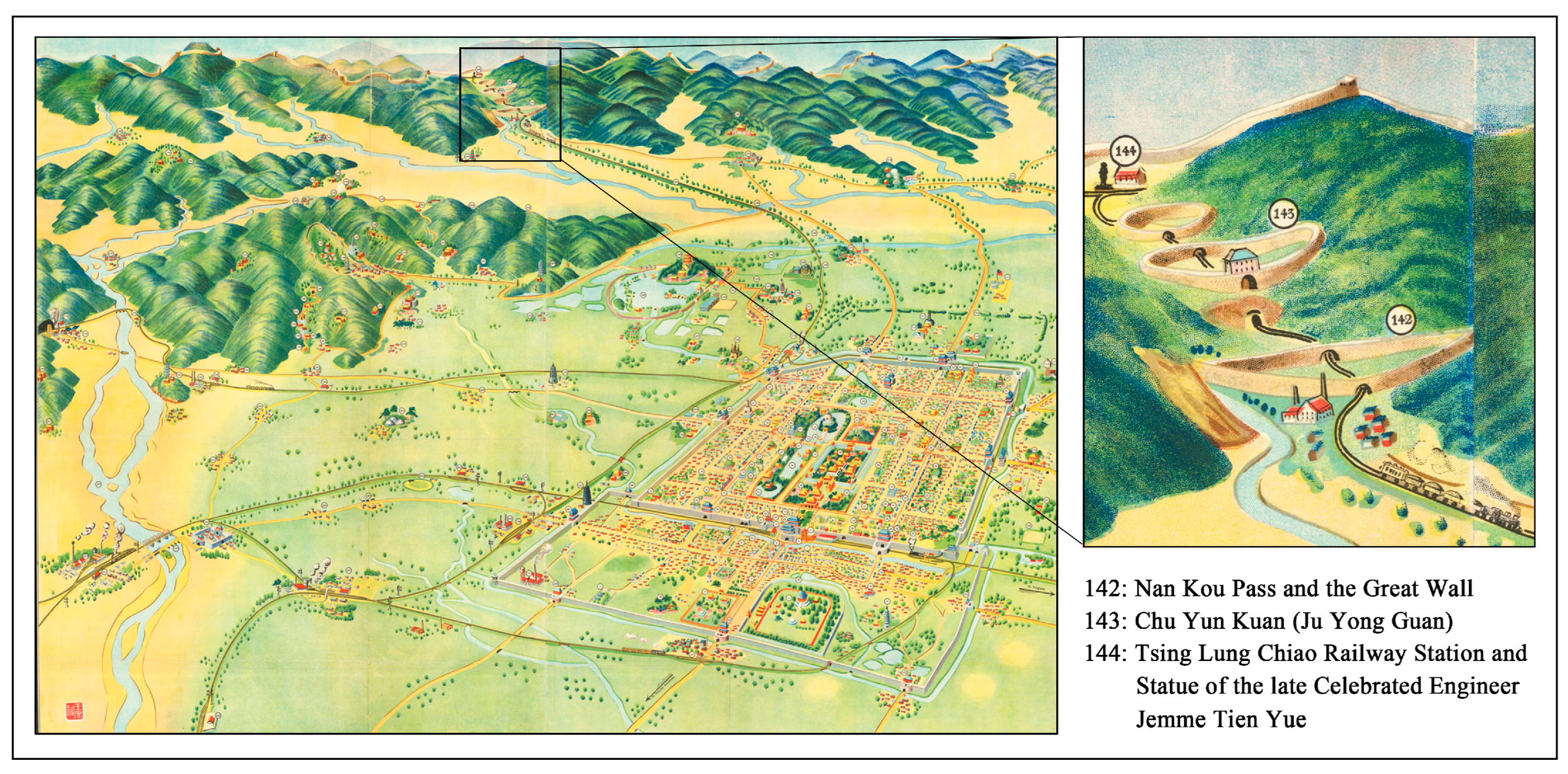
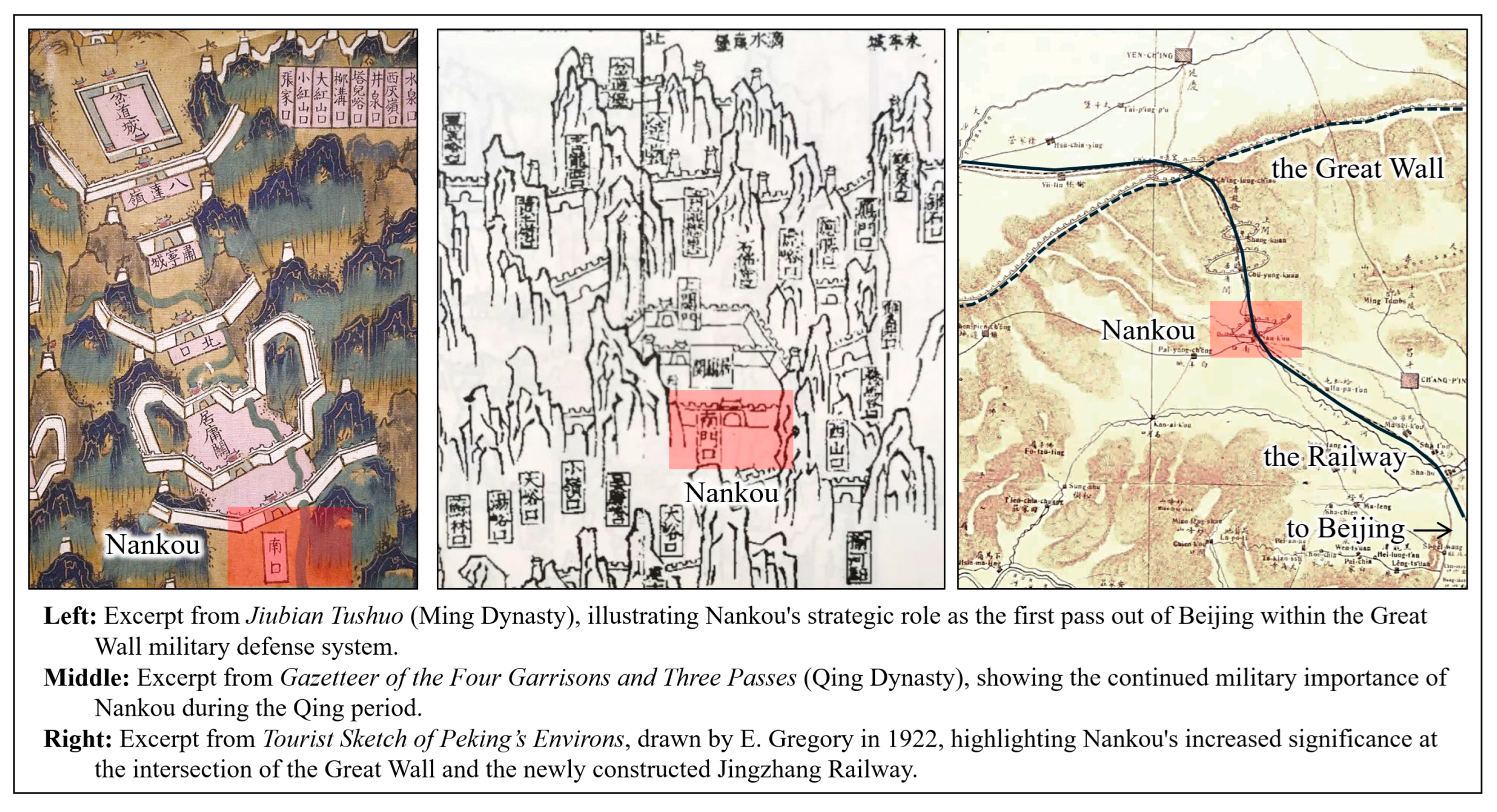
The scope of this study covers the entire jurisdiction of Nankou Village, with a particular focus on the built-up area of the traditional village within Nankou. Located in the northwest of Changping District, Beijing, Nankou Village falls under the administration of Nankou Town in Changping District, as depicted in Figure 1. The village spans approximately 3.8 square kilometers, situated at the confluence of the North China Plain and the Yanshan Mountains, endowing it with a unique geographical position nestled between two mountain ranges. To the northwest lies the Juyongguan Pass, while the southeast borders the urban areas of Beijing. This strategic geographic location has historically rendered the Nankou region a crucial military stronghold in the northwestern approaches to Beijing, making it a coveted site in military strategies (see Figure 2).
The villages in the Nankou region trace their origins back to the Northern Wei period. Due to its strategic terrain, a military garrison was established here during the Yuan dynasty, which gradually underscored the region’s military significance. In the Ming dynasty, fortifications were constructed, and perimeter walls were erected alongside defensive installations such as gates, water gates, bastions, and beacon towers—all integral components of the Great Wall’s military defense system [22]. During the late Qing and early Republic periods, this area developed into a crucial commercial route leading from Beijing to the north. In 1906, the Beijing–Zhangjiakou Railway was built, with tracks running north–south along the village’s eastern flank, further consolidating Nankou’s transportation significance. In the World War II, due to its unique military and transportation position, Nankou became a site of intense conflict, marked by the Battle of Nankou. Today, only ruins survive from the Nankou fortress, including sections of the southern city wall and gate, along with two beacon towers situated in the northwest and northeast. Meanwhile, the Beijing–Zhangjiakou Railway has been repurposed as part of the suburban rail system of Beijing and remains operational.
In 2014, the Chinese government officially defined traditional villages as “villages possessing tangible and intangible cultural heritage with significant historical, cultural, scientific, artistic, social, and economic value” [23]. Nankou Village, renowned for its ancient history, displays a unique interweaving pattern of “village–Great Wall–railway”, combined with the passage of Guangou river and the encircling northern mountains, making it a convergence point of traditional intangible and tangible values. These intertwined conditions render the historical and spatial development patterns of the village complex, necessitating further study.

2.2. Data Sources

The data used in this research consist of three main categories: historical documents, imagery data, and spatial geographic information (Table 1). First, historical documents were gathered from various sources, including physical books, the National Library of China Digital Collections (https://www.nlc.cn/web/), and firsthand contributions from history enthusiasts on various internet platforms. Official documents such as government planning files and land use maps were provided by the Nankou Village Residents’ Committee. Second, satellite imagery was sourced from Google Earth, dated 11 April 2023, while aerial photographs were captured by the researcher in December 2023. Third, building data and information on roads, railways, rivers, and city walls were obtained by tracing satellite and aerial images, then verified and refined through field surveys conducted in December 2023, January 2024, and May 2024 to ensure observational accuracy and timeliness. Additionally, informal exchanges were conducted with villagers and staff from the village committee to collect information on daily life and oral histories within the village, thereby supplementing gaps in the written documentation.

2.3. Research Methodology

To investigate the mechanisms through which history and space interact in Nankou Village, this study employs a mixed-methods approach combining quantitative and qualitative analyses. Initially, a comprehensive village database will be developed using kernel density analysis and ArcGIS spatial analysis to initially explore the spatial distribution characteristics of the village. Subsequently, quantitative indicators for each historical element are integrated with qualitative characteristics to establish mappings that bridge spatial quantification and historical narratives. On the quantitative side, MGWR analysis and standard deviation ellipse analysis, combined with shape indices, are applied to examine the objective laws of village spatial development and how history shapes its spatial forms. On the qualitative side, within the theoretical frameworks of Halbwachs and Nora, the study combines documentary research and informal exchanges with villagers to collect village history and oral histories. It qualitatively analyzes how space carries and reshapes the village’s historical memory. Finally, the quantitative and qualitative findings are synthesized and cross-validated under a unified categorization system to ensure the logical coherence of the research outcomes, thereby extracting the “history–space” interaction mechanism of Nankou Village (see Figure 3).
Map data forms the critical foundation for the analysis in this study, providing both an intuitive overview of the village and supporting objective data analysis. By meticulously tracing satellite imagery and aerial data, supplemented by field survey information, the study achieved vectorized processing of maps, creating detailed CAD diagrams of the traditional village’s built-up areas. These diagrams clearly delineate the scope of the traditional village, building outlines and heights, construction dates, and key elements such as surrounding walls, beacon towers, railway lines, rivers, and highways covering the entire village area. These CAD data were then imported into ArcGIS Pro 3.0.2 software for spatial analysis, generating key data such as kernel density and feature distances, which laid the groundwork for more in-depth subsequent analyses.
Kernel density analysis is a method that calculates density within a specified range by selecting individual feature points (the centers of building outlines) as reference centers. By specifying a radius and applying a kernel function, this analysis produces a spatial density surface, visually revealing the density and clustering of spatial feature points [24,25]. In this research, the results of the kernel density analysis depicted the density of buildings within a specified range around each building’s center point. Higher density values indicate higher construction intensity in the specific area, whereas lower density suggests relatively weaker construction intensity.
The formula for kernel density analysis is:
D ( x i , y i ) = 1 u r i = 1 u k ( d r )
where D (xi, yi) represents the kernel density at the i-th point; r is the threshold for distance decay; u denotes the number of features within a distance less than or equal to (xi, yi); k is the spatial weighting function; and d is the Euclidean distance between the current point and point (xi, yi).
Compared to traditional models, GWR model can reveal spatial heterogeneity in the effects of different factors on the dependent variable, showing how these influences vary with geographic location. However, given the historical factors involved in this study differ in terms of era, scale, and impact range, MGWR offers greater advantages over GWR. MGWR can measure differences in influence among various factors, more accurately fitting these changing characteristics [26].
The study employed the MGWR model to quantitatively analyze the impact of historical elements on the internal spatial characteristics of the traditional village’s built-up area, with the formula expressed as follows:
y i = β b w 0 μ i ,   υ i + j = 1 k β b w j μ i ,   υ i x i j + ε i
where yi is the assignment result of the kernel density analysis at each building point element; βbω0ii) is the constant term; μii is the spatial coordinate of the i-th building; βbωjii) is the regression coefficient for the j-th influencing factor fitted using a specific bandwidth; xij is the observation value of the j-th independent variable at the i-th concentration index; and εi is the residual error.
Standard Deviation Ellipse (SDE) is a spatial regression tool used to quantify the spatial attributes of geographic features, revealing their trends of spatial aggregation, orientation, and dispersion [27,28]. The primary parameters of this analysis include the center point of the regression ellipse, orientation angle, foci, major axis, and minor axis. The major axis typically indicates the primary directionality of geographic features, while the minor axis reflects their dispersion. The flattening ratio of the ellipse, defined as the ratio of the major axis to the minor axis, indicates the relative relationship between directionality and dispersion. The calculation formula is as follows:
tan θ = i = 1 n w i 2 x i 2 i = 1 n w i 2 y i 2 + i = 1 n w i 2 x i 2 i = 1 n w i 2 y i 2 2 + 4 i = 1 n w i 2 x i 2 y i 2 2 i = 1 n w i 2 x i 2 y i 2
σ x = i = 1 n w i x i cos θ w i y i sin θ 2 i = 1 n w i 2
where θ is the rotation angle and σx and σy are the standard deviations along the x-axis and y-axis, respectively. This study employed the standard deviation ellipse method within the ArcGIS platform to conduct an in-depth examination of the internal spatial pattern of Nankou Village’s built-up area, including the evolution of the village’s spatial distribution center, as well as its directional and dispersal tendencies.
Landscape Shape Index (LSI) is adopted to evaluate the spatial morphological complexity and structural compactness of the village. The calculation formula is as follows:
L S I = P 2 A
where P represents the total perimeter of the spatial unit and A is the area. A lower LSI value indicates that the village’s spatial form is closer to a regular geometric shape (such as a circle), suggesting a more compact spatial structure. Conversely, larger values indicate that the morphology tends to be more irregular, with greater external interference and more dispersed structure [29].

3. Analysis and Results

3.1. Definition and Reshaping of Village Spatial Development by Historical Elements

Nankou Village, owing to its strategic terrain, has long been a contested military site and a vital thoroughfare for trade and travel. Following the construction of the Beijing–Zhangjiakou Railway in the early 20th century, the area progressively formed a distinctive spatial layout, shaped collectively by the Great Wall, the railway, and post roads. Each major historical transition has exerted a notable influence on the village’s internal spatial organization and the distribution of buildings.
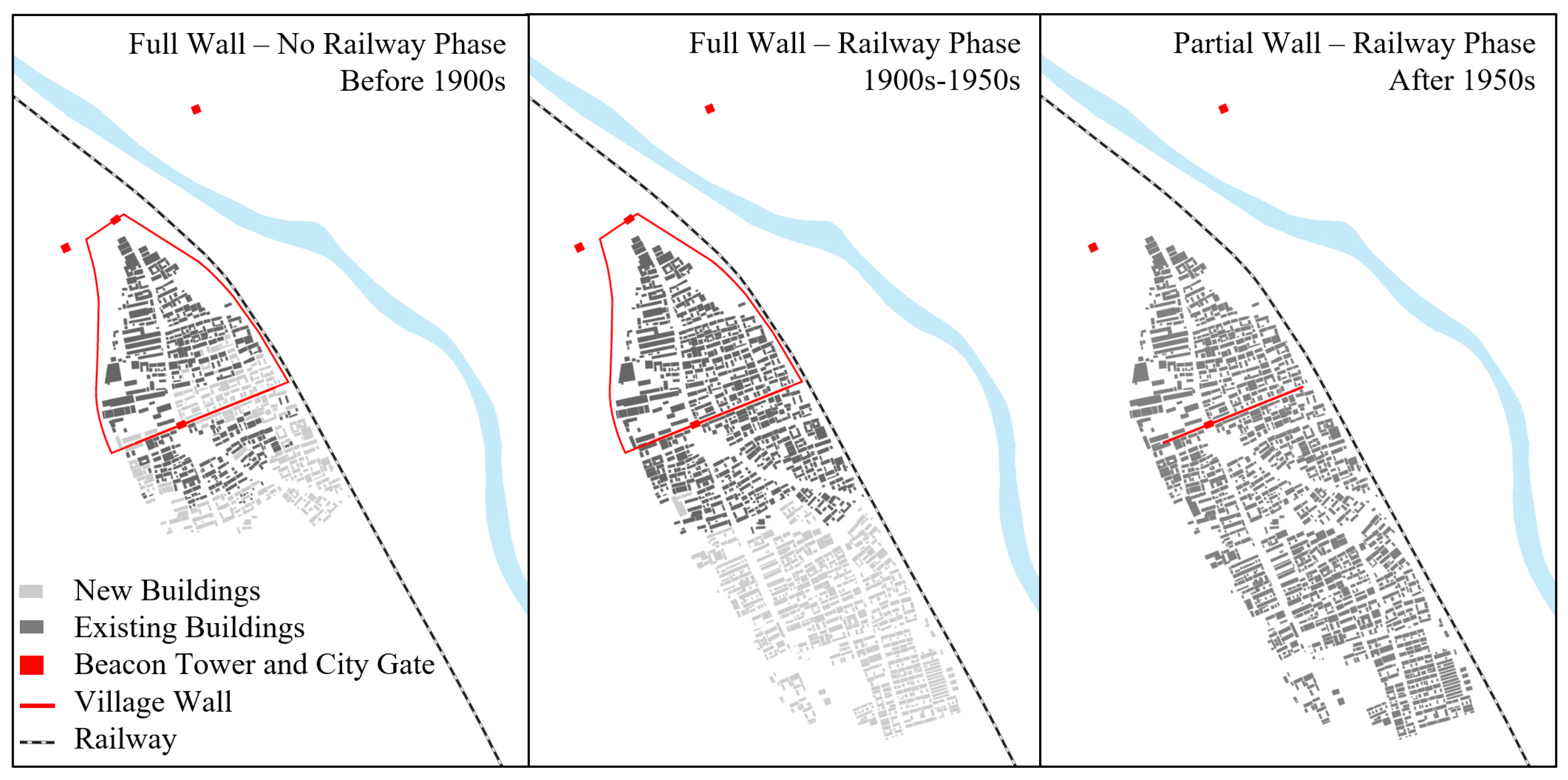
This study focuses primarily on the mechanisms through which the Great Wall’s military defense system—including its auxiliary structures such as walls and beacon towers—along with railway lines, post road routes, natural topography, and waterways, have influenced the formation of the village’s spatial structure. The historical development of Nankou Village is divided into three principal phases (see Figure 4).
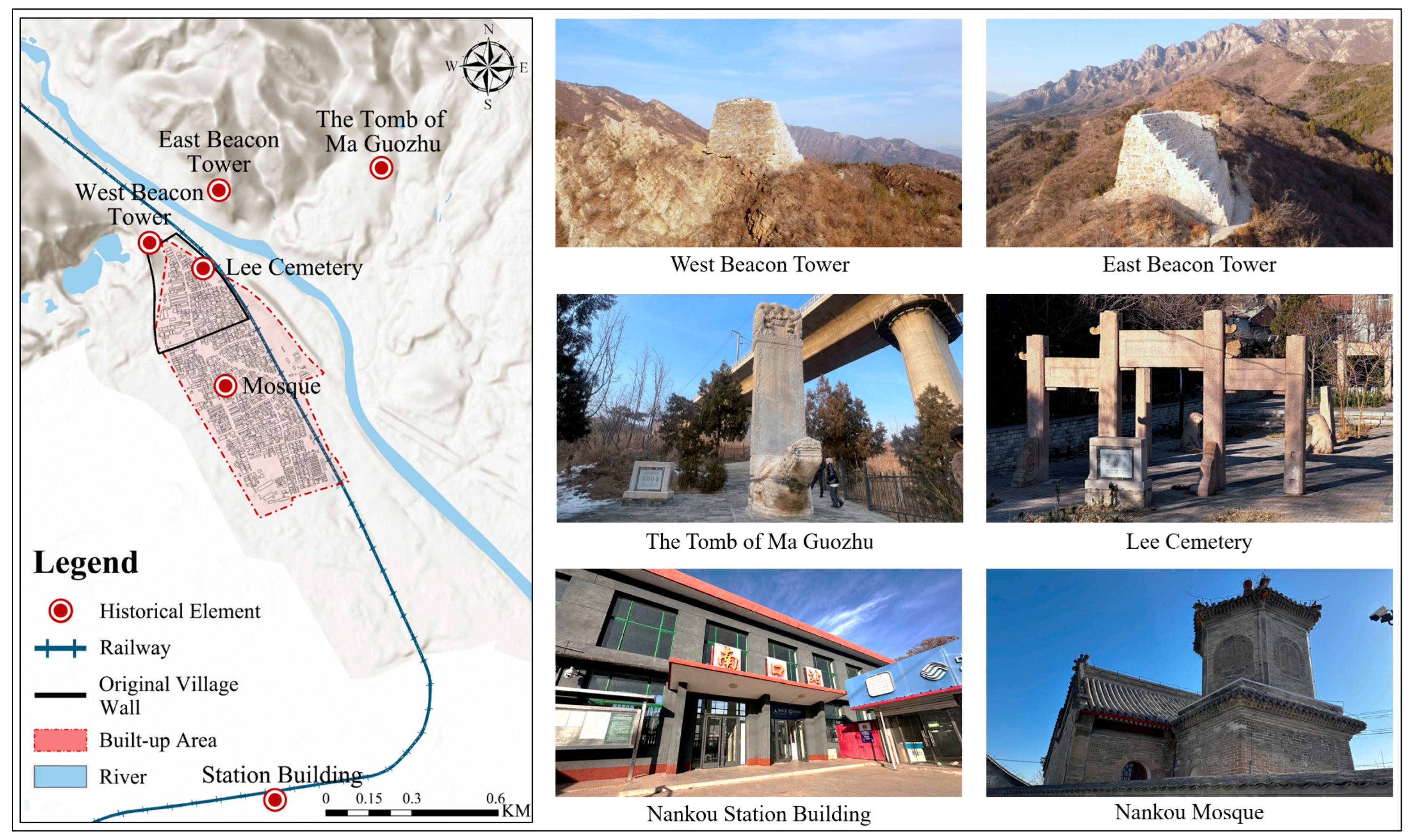
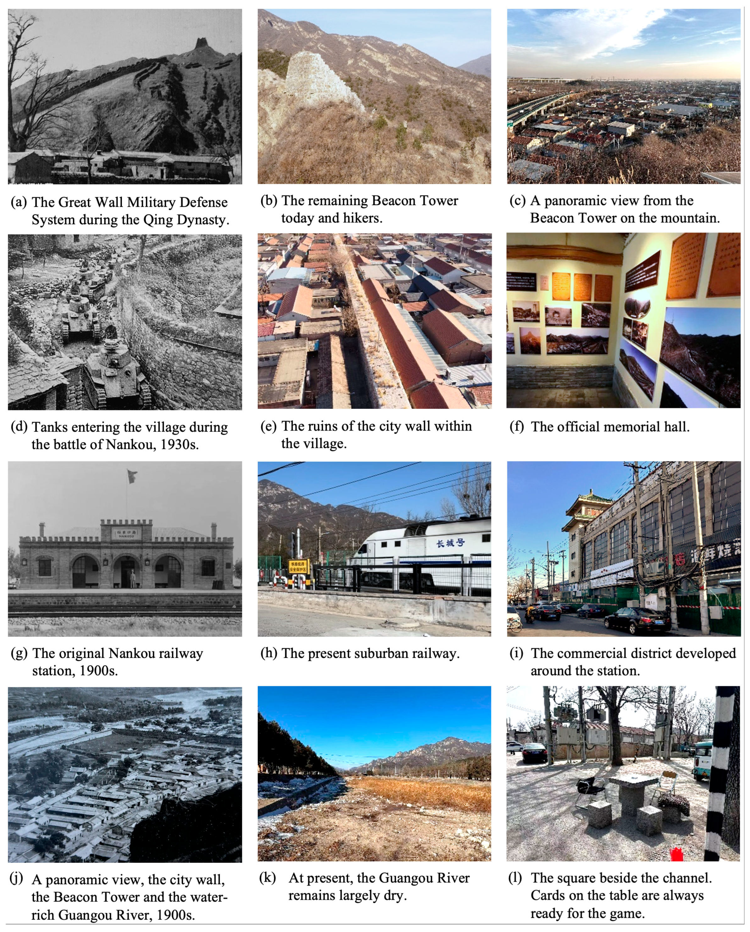
Phase 1: “Walled, No Railway”. In reviewing the development trajectory of fortress forms along the Beijing section of the Great Wall, it is evident that prior to the late Ming dynasty, the Beijing area was consistently at the forefront of ethnic political and military struggles. The Great Wall and its adjacent villages, such as passes and garrison towns, served as critical military gateways and formidable spatial barriers for defending Beijing [30]. During the mid to late Qing dynasty, as frontiers expanded outward and conflicts in Beijing stabilized, coupled with famines in the Central Plains driving inland population migration outward, the population along the Great Wall villages increased, leading to prosperous trade routes. Consequently, Nankou Village’s spatial development began to extend beyond the original wall constraints, expanding from city gates outward [31]. During this period, the social functions of Nankou town became more refined, and its spatial structure was largely established. Historical sites like Lee Cemetery, the Tomb of Ma Guozhu, and the mosque were all constructed during this time (see Figure 5). While continuing to fulfill military defense roles, Nankou increasingly took on the functions of commerce, travel, and transportation transit.
Phase 2: “Walled, With Railway”. At the end of the Qing dynasty, under the influence of the Chinese bourgeois enlightenment and the Self-Strengthening Movement, the construction of the Beijing–Zhangjiakou Railway commenced. The project was segmented into three parts, with the section near Nankou classified as the “Nankou to Chadaocheng segment”, extending 16.5 km. Among these, the Guangou section was considered the most challenging to construct. The railway’s north–south passage through the eastern part of Nankou Village imposed a barrier effect, somewhat limiting east–west spatial expansion. Due to the agglomeration effects resulting from the station’s establishment, Nankou Town’s center flourished, while Nankou Village’s spatial development slowed [32,33]. At this time, the railway freight transition function and postal functions of Nankou became increasingly prominent.
Phase 3: “Ruined Walls, With Railway”. During the Northern Expedition in 1926, the gate towers of Nankou suffered severe damage due to artillery fire. In the Battle of Nankou during the World War II, the town served as a crucial defensive position for Nationalist forces resisting Japanese invasion, which caused further damage to the walls. Following the establishment of the People’s Republic of China in 1949, sections of the wall were dismantled during the construction of the Beijing–Zhangjiakou Highway. Presently, most of the walls no longer exist, and the remaining structures exhibit clear repair traces. In March 2013, the Great Wall (Nankou Town) was listed as a national key cultural relic protection unit.
According to historical records, the built-up area of Nankou Village was initially concentrated in the northern part during the first phase. The southeastern sector within the village walls remained largely unbuilt, while rows of structures emerged outside the southern gate, likely aligned with early commercial post roads. In the second phase, settlement expanded progressively along a north–south axis, with two new residential clusters constructed during this period. By the third phase, the built-up area achieved continuous development along the north–south direction. This spatial expansion was accompanied by the construction of modern infrastructure, including residential compounds, agricultural markets, and schools around the village. The evolution of historical elements and the expansion of the built-up area clearly reinforced each other, reflecting an intrinsic spatial linkage in which the two elements mutually guided and constrained one another.

3.1.1. Analysis of the Impact of Different Historical Elements on Village Spatial Development

In the quantitative analysis, this study employs a MGWR model to analyze the specific impact of historical elements on the spatial morphology of the village. Compared with conventional regression models, MGWR can reveal the intensity of influence (i.e., impact coefficients) at different geographic locations, making it particularly effective for exploring the spatial heterogeneity of individual factors.
The study proposes that the results from the regression analysis not only demonstrate the guiding role at the material level, but also uncover an “inertia” of historical spatial patterns. Even when historical elements themselves change, the spatial boundaries, transport routes, and settlement cores they established continue to subtly influence residents’ living choices and spatial preferences. Considering practical circumstances, this study comprehensively examined factors such as city walls, railways, commercial post roads, and natural geographical conditions. Due to the antiquity of some streets and alleys, it is challenging to verify their actual ancient passage distances. Therefore, ArcGIS was employed to calculate the straight-line distance from the center points of all 1579 buildings to the aforementioned factors, establishing a database for analyzing the impact of different historical elements on village spatial development. The index system and calculation methods are detailed in Table 2.
To address potential multicollinearity among variables and avoid biased estimates, a multicollinearity test was conducted before including them in the MGWR model. This study used IBM SPSS Statistics 27 software to perform a multicollinearity test on the six independent variables. The results indicate that although all six influencing factors were statistically significant, the Gate Factor, Post-road Factor, and Elevation Factor exhibited severe multicollinearity issues due to high VIF values (exceeding 5) and low tolerance levels. Consequently, these three factors were excluded from subsequent analysis. In contrast, the VIF values for the City Wall, Railway, and River Factors fell within an acceptable range, supporting their retention in the MGWR model (see Table 3).
To demonstrate the suitability of the MGWR model for this analysis, both the GWR and MGWR models were applied to the variables for comparative modeling. The findings demonstrate that the MGWR model outperformed the GWR model, showing a better goodness-of-fit with a higher R2 value and a lower corrected AICc value. This suggests that the MGWR model offers superior goodness-of-fit (Table 4), more effectively explaining the spatial heterogeneity of the variables and more accurately capturing the impact of various historical elements on the spatial distribution differences among villages.
The spatial distribution of buildings in Nankou Village has been shaped by historical elements such as city walls and railways across different periods, leading to pronounced regional variations in layout. Following regression analysis using the MGWR model, the influence coefficients are summarized in Table 5, with visualized results interpreted below (Figure 6):
  • The intercept represents the baseline expected value of the dependent variable at specific geographic locations when the independent variables are zero, reflecting the influence of factors other than historical elements, such as natural and commercial conditions, on the village’s building layout. As shown in Figure 6, the intercept is positive across the entire village, with regression coefficients ranging from 6.757 to 18.365 and an average of 11.747. Overall, these coefficients are highest in the central area, followed by the northern area, and lowest in the southern area.
  • The influence coefficients for the city wall range from −14.032 to 13.031, with an average of 1.684, generally exhibiting a north-high-south-low pattern aligning with the intercept regression results. The northern part of Nankou Village exhibits a positive attraction effect, while the southern part shows a negative repulsion effect.
  • The railway line’s influence on the village’s building layout ranges between −9.217 and 8.875, with an average of 1.234. It generally exhibits a distribution pattern of positive attraction in the south and negative repulsion in the north.
  • The influence of the Guangou River on building layout ranges from –12.457 to 8.419, with an average of –4.544, showing a general pattern of higher values in the northeast and lower values in the southwest. This reflects a positive attraction effect in areas closer to the river and a negative repulsion effect in areas farther away.

3.1.2. Analysis of the Impact on Village Spatial Development Under Multi-Factor Coupling

The individual impacts of various historical factors on the internal spatial layout of village buildings were discussed. To validate these findings and further examine the combined effects of multiple factors on village spatial development, this paper employs standard deviation ellipse analysis along with shape indices to investigate in depth the evolutionary characteristics of development across three distinct historical stages. Compared with single-factor analysis, the multi-factor coupling approach more clearly reveals the overall trends and patterns in village spatial development. It offers a broader perspective that not only clarifies the direction of development but also provides macroscopic verification of the single-factor analysis results.
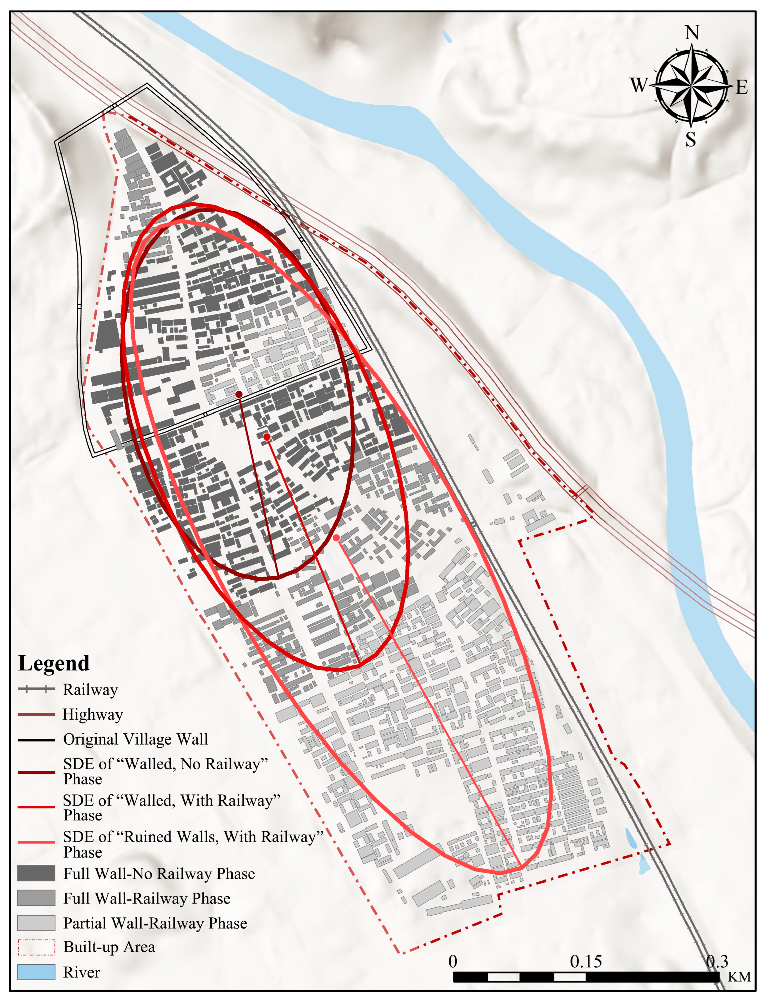
Based on historical records and oral accounts from villagers, the built-up areas of the village during three different historical stages were delineated. Standard deviation ellipse regression analysis and shape index calculations were performed for each stage’s building layouts. In the first stage, spatially constrained by the city walls, the building distribution was relatively dense, with some structures extending beyond the walls along the southern gate towards the post road. The analysis for this stage resulted in a smaller ellipse with a lower axis ratio and a shape index of 21.13, reflecting high compactness in spatial distribution. In the second stage, the building layout began expanding southeastward along the railway, significantly enlarging the built-up area and giving the village an elongated overall pattern. As a result, the ellipse became larger, the axis ratio increased, and the major axis exhibited a northwest–southeast orientation. The shape index rose to 26.40, indicating that the spatial structure began to loosen, presenting an outward expansion trend. In the third stage, the spatial configuration of Nankou Village’s built-up area became more defined, continuing its southeastern expansion. However, development was restricted further east–west by the railway’s spatial blockade. During this stage, the ellipse reached its largest size with the highest axis ratio, and the major axis continued to extend in the northwest–southeast direction, while the shape index increased to 34.46. These results further demonstrate that spatial development became more dispersed, reducing compactness (Figure 7).
In summary, the standard deviation ellipse regression analysis across the three stages indicates that the spatial development of Nankou Village exhibits clear phasic, directional, and expansive characteristics. On the east–west axis, development was constrained by multiple factors, such as the city walls, railways, and river, prompting the overall layout to extend along the north–south axis, becoming more elongated. Given that both the railway and river align “northwest–southeast”, the village increasingly reflected this directional feature over time. Thus, the standard deviation ellipse analysis has revealed the influence of historical factors on spatial layout from a macro perspective, thereby providing strong support for constructing a “history–space” interaction mechanism.

3.2. Bearing and Reshaping of History by Physical Space

In the qualitative analysis, this study drew upon a wide range of historical documents and photographic materials, supplemented by oral histories provided by villagers, to examine how physical spaces both preserve and reshape historical memory. This approach helps elucidate the process through which historical memory is reconfigured amid evolving spatial patterns in Nankou Village.
Traditional villages are important venues for carrying social memory [34]. The analysis is guided by the theoretical framework of French sociologist Maurice Halbwachs’s “collective memory” and French historian Pierre Nora’s concept of “realm of memory” (“lieux de mémoire”). Halbwachs emphasized that individual memory is continually socialized through group activities rather than purely subjective perception [35]. Nora revealed how physical spaces are continuously endowed with new historical memories through social practice [36]. From this perspective, the physical space of Nankou Village is not static but is constantly activated and reshaped through the practices and memories of its residents.
To further discuss the role of the Great Wall’s military defense system, the Beijing–Zhangjiakou Railway, and Guangou in preserving history and reshaping memory, this study highlights three key aspects:
First, the Great Wall and its associated structures, including Nankou’s city walls and beacon towers, have evolved into quintessential realms of memory through various practices. Historically, these beacon towers functioned as platforms for igniting beacons to signal enemy threats (see Figure 8), as ancient Chinese texts describe: “Beacon towers serve as observation posts. When there is a border alarm, fires are lit [37].” During World War II, the defense system formed by the Great Wall and city walls became a key line of resistance against Japanese forces, as recorded in the Local Chronicles of Nankou: “The Battle of Nankou lasted 22 days, with 10,698 soldiers wounded and 5945 sacrificing their lives [38].” This continuity in defensive function largely explains why the settlement pattern long remained confined within the city walls. In the present day, villagers regard the beacon towers as hiking destinations and vantage points, thereby establishing them as iconic landmarks of Nankou (see Figure 9). From the perspective of memory studies, these structures continually acquire new meanings through changing practices, thereby transcending their original military significance and constructing layered collective memories that facilitate historical reinterpretation.
Second, the Beijing–Zhangjiakou Railway has shaped new community memories through daily practices. Its construction turned Nankou from a military fortress into a critical transport hub linking Beijing with northern frontiers (see Figure 9). Prior to the railway, Nankou’s commercial center was along the northern post road; after its completion, the Nankou Station area fueled commercial density in the southern region. As noted in the Annals of Nankou: “After the full operation of the Beijing–Zhangjiakou Railway in 1909, Nankou emerged as a military and transportation stronghold, giving rise to various commercial shops [39].” Beyond its grand historical significance, the railway is also deeply woven into villagers’ everyday lives. The regular train schedules serve as timekeepers, while the station area becomes essential for shopping and social interaction. Through Halbwachs and Nora’s theories, the railway, with its transportation and rhythmic functions, gradually becomes internalized in residents’ daily practices and accumulates as new communal memories, overlaying its industrial heritage history.
Third, Guangou, a significant water system in northwestern Beijing, embodies the collective identity of the village. Flowing from north to south through the village, it fundamentally shaped the spatial organization, as recorded in the Gazetteer of the Four Garrisons and Three Passes which notes Nankou City was “built across the water” in 1403. Before modernization, residents lived alongside the water, constructing channels to fulfill water needs, which turned the banks into spaces for interaction and leisure, thereby driving early village development. Although modern infrastructure has reduced reliance on natural sources, these channels remain critical sites for gathering and communication. Based on the realms of memory theory, Guangou’s geographical role has lessened, yet it continues to evoke emotional cohesion at the group level, serving as a vital space for maintaining community identity through intergenerational customs.
In conclusion, the rich historical sites of Nankou have continually embedded themselves in varied social practices through functional transformation, deeply participating in the construction of historical memory and shaping new historical narratives (see Figure 10).

3.3. Comprehensive Synthesis and Joint Display

This research reveals that historical elements are integral to the spatial construction process, demonstrating their roles in defining, guiding, and periodically reconstructing village morphology through features such as city walls, railways, and waterways. Conversely, the spatial venues of Nankou, which carry national narratives and villagers’ daily experiences, validate the shaping influence of historical elements on space and are continually imbued with new meanings through collective memory and life practices, thus becoming part of history itself. This mechanism of historical bearing and reshaping is reflected in the spatial impact patterns revealed by quantitative analysis, ensuring consistency in direction, mechanism, and spatial distribution. Table 6 presents the corresponding connections between quantitative and qualitative evidence.

4. Discussion

4.1. The “History–Space” Inter-Construction Mechanism in Nankou Village

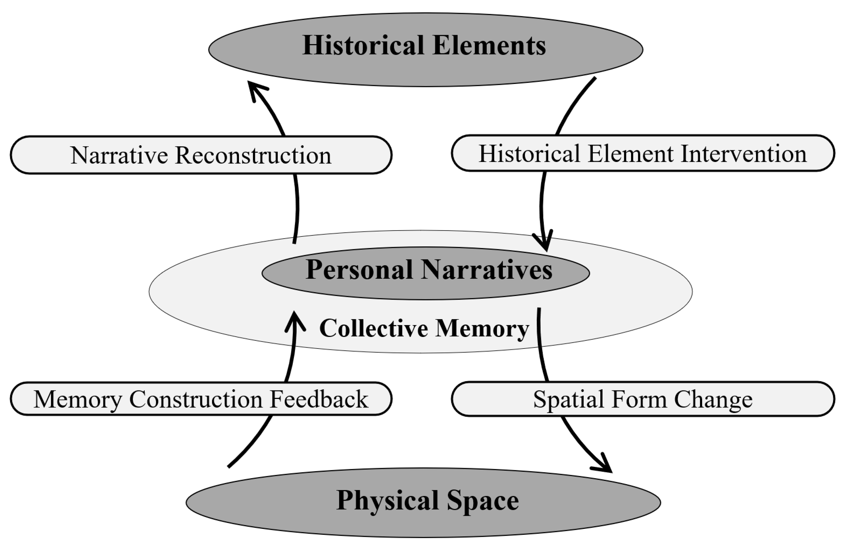
Building upon these two dimensions, this paper proposes a dynamic model of the “history–space” inter-construction mechanism. This mechanism operates as a bidirectional, multilayered, and cyclical process. On the one hand, historical elements are embedded into space in material form, guiding its morphological and functional evolution. On the other hand, spatial venues reshape memories through villagers’ daily lives and various social practices, which subsequently feed back into historical narratives. Under external influences such as urbanization, policy direction, and tourism development, these narratives undergo continuous reinterpretation and reenactment, ultimately forming a cyclical pathway of “historical element integration—spatial form transformation—memory reconstruction—narrative revision”. Figure 11 illustrates the mutual influence between history and space.

4.2. Methodological Contributions and Limitations

Since the mid-20th century, there has been increasing focus on concepts like “society”, “community”, and “space”, and therefore discussions about the inter-construction mechanisms between intangible factors and physical spaces have become increasingly important [40,41]. For traditional villages like Nankou, intangible factors, especially historical ones, play an indispensable role in spatial shaping. However, current studies on village spatial morphology often concentrate on contemporary social factors, with historical influences being less explored [42]. Moreover, these studies frequently focus on specific influencing factors using single methods, overlooking the outcomes of either separate or coupled multifactor inter-constructions and the reverse impact of space on history. This paper aims to address these research gaps.
In terms of quantitative methods, this study innovatively applies the MGWR to analyze the morphology of village built-up areas. This method evaluates the impact of different factors at various scales across locations, offering a deep analysis of spatial heterogeneity. Additionally, by exploring spatial morphology under multi-factor coupling, the study unveils intrinsic patterns in village spatial changes.
Regarding the qualitative theoretical framework, this study analyzes how traditional village spaces bear and reshape personal memory and history through the theories of Halbwachs and Nora, providing insights for applying these theories to traditional villages. However, with the advancement of urbanization in recent years, the Great Wall and its surrounding areas have gradually been endowed with modern political functions. The commercial redevelopment along the railway line has also intensified. Previously “living realms of memory” transformed into “exhibition-like historical spaces”, where villagers’ personal memories are marginalized, replaced by a uniform “official narrative”. Consequently, these spaces risk losing their original historical depth. Therefore, within the “realm of memory” framework, it is essential to question: when memory no longer stems from spontaneous social practices, how are history and memory selected, reconstructed, and imbued with new meanings by market and political forces? This remains a topic worthy of further exploration.

4.3. Broader Applications and Future Prospects

The paper examines how this inter-construction mechanism manifests within the specific historical and geographical context of Nankou Village. To preliminarily explore the potential for extrapolating this mechanism, the study attempts comparisons with other traditional villages in Western Beijing. For example, Linggong Village in Miyun District, part of the Great Wall Cultural Belt, thrived during the Ming Dynasty due to its role inmilitary frontier defense. Its core spatial structure is centered around the “fort city ruins”, making it one of the earliest settlement centers in the area. Meanwhile, spatial elements like forts and temples within the village, through their material existence, serve as anchors for sustaining, transmitting, and reshaping memory [43]. Similarly, research on Dingjiatan Village along the Jingmen Railway (Beijing–Mentougou) shows that the railway defined the village’s narrow linear spatial structure and became interwoven with villagers’ daily lives, fostering a regional spatial identity centered on historical industrial heritage [44]. Therefore, the fundamental mechanism of “historical element intervention in spatial morphology evolution and the renewal of historical memory expression” holds explanatory potential across broader regions. For instance, along the Great Wall in Gansu, China, settlements formed because of ancient military defense systems; in Germany’s Ruhr area, coal mining led to village emergence and linear spatial layouts; and in Japan’s Magome-juku on the Nakasendo, the demand for post-station transportation resulted in a street-centric configuration. Despite varying historical backgrounds and types of cultural resources, this mechanism demonstrates adaptability and potential for wider application, warranting further validation and exploration across diverse regions and village types.
As a confluence of the Great Wall cultural belt and the Beijing–Zhangjiakou railway industrial heritage, Nankou Village possesses a wealth of intangible elements. In practical terms, this research aims to overcome spatial barriers, create a continuous and communal network of historical and cultural spaces, reinforce the protection of the Great Wall and the maintenance of the Beijing–Zhangjiakou Railway, and facilitate the collaborative conservation planning of the “Village—Great Wall—Railway” framework. This approach offers a reference for further interpreting the spatial evolutionary patterns and influencing factors of traditional villages, with the ultimate aim of fostering their modernization and sustainable development through multidisciplinary cross-disciplinary cooperation.

5. Conclusions

This study examines the evolution of spatial morphology in Nankou Village across three developmental stages, focusing on how historical elements influence spatial forms and how physical space embodies and feeds back into historical memory. The findings reveal the “history–space” inter-construction mechanism in Nankou Village and yield the following conclusions:
  • Different types of historical elements exert distinctly heterogeneous impacts on the village’s spatial morphology, manifesting as guidance, restriction, or inhibition. For instance, the Nankou city wall guided the development of the built-up area at the village’s northern end; the railway shaped the development trend toward the south, while the Guangou River primarily guided construction in the northeast corner and inhibited southern expansion. Through the phases from “walled and without railway” to “coexisting walls and railway”, and ultimately to “remnant walls and railway-dominated”, the village center gradually shifted southward. This resulted in an elongated northwest–southeast form, with increasing complexity. These processes demonstrate that historical elements are not abstract backgrounds but are concretely embedded within the village space, continuously shaping and reconstructing its structure and forming the core logic of spatial evolution.
  • Locations such as Nankou’s city walls, Great Wall beacon towers, and railway tracks symbolize grand national narratives while deeply integrated into the villagers’ daily lives. They carry both collective and personal memories. As these spaces are continuously perceived and practiced, they become central vehicles for reshaping memory, allowing historical narratives to be continually reconstructed and regenerated within everyday settings. Thus, Nankou Village’s history manifests as a “living history” embedded within spatial practices. By quantitatively revealing patterns and qualitatively providing explanations, these methods cross-verify and complement each other, ensuring the reliability of the research findings and the complexity of the narrative.
  • The relationship between history and space in Nankou Village is not a straightforward linear causality. Instead, a persistent and interactive “history–space” mechanism emerges, characterized by its structured, narrative, and dynamic nature. This interaction forms a “history–space” inter-construction mechanism characterized by structure, narrativity, and dynamism. This mechanism shapes the physical spatial layout while sustaining local memory and cultural identity. Moreover, similar logics may exist in other villages with distinct historical elements, suggesting the mechanism’s adaptability and potential for theoretical extrapolation in broader contexts.

Author Contributions

Conceptualization, Y.Y. and L.X.; methodology, Y.Y., L.X. and H.W.; software, H.W. and Y.Y.; validation, Y.Y., L.X. and H.W.; formal analysis, Y.Y.; investigation, Y.Y. and L.X.; resources, Y.Y., L.X. and H.W.; data curation, H.W. and Y.Y.; writing—original draft, Y.Y.; writing-review and editing, Y.Y., H.W. and L.X.; visualization, H.W. and Y.Y.; supervision, Y.Y., L.X. and H.W.; project administration, Y.Y. and L.X.; funding acquisition, L.X. All authors have read and agreed to the published version of the manuscript.

Funding

This research was funded by National Natural Science Foundation of China (grant number: 52008019).

Data Availability Statement

Data can be provided upon request from the corresponding author.

Acknowledgments

The authors would like to thank the village committee and the villagers of Nankou for their support of this project.

Conflicts of Interest

The authors declare no conflict of interest.

References

  1. Wang, H.; Chiou, S. Study on the sustainable development of human settlement space environment in traditional villages. Sustainability 2019, 11, 4186. [Google Scholar] [CrossRef]
  2. Huang, D.; Zhang, N.; Zhang, Y. Traditional village landscape identification and remodeling strategy: Taking the Radish village as an example. Mob. Inf. Syst. 2022, 2022, 2350310. [Google Scholar] [CrossRef]
  3. Zhang, Z.; Xu, F. Times and politics background of traditional villages conservation in rural China. Res. Herit. Preserv. 2018, 3, 1–7. [Google Scholar] [CrossRef]
  4. Vos, W.; Meekes, H. Trends in European cultural landscape development: Perspectives for a sustainable future. Landsc. Urban Plan. 1999, 46, 3–14. [Google Scholar] [CrossRef]
  5. Zhu, Q.; Liu, S. Spatial morphological characteristics and evolution of traditional villages in the mountainous area of Southwest Zhejiang. ISPRS Int. J. Geo-inf. 2023, 12, 317. [Google Scholar] [CrossRef]
  6. Chen, X.; Xie, W.; Li, H. The spatial evolution process, characteristics and driving factors of traditional villages from the perspective of the cultural ecosystem: A case study of Chengkan Village. Habitat Int. 2020, 104, 102250. [Google Scholar] [CrossRef]
  7. Zheng, X.; Wu, J.; Deng, H. Spatial distribution and land use of traditional villages in Southwest China. Sustainability 2021, 13, 6326. [Google Scholar] [CrossRef]
  8. Yang, R.; Pan, Y.; Xu, Q. Space diversification process and evolution mechanism of typical village in the suburbs of Guangzhou: A case study of Beicun. J. Geogr. Sci. 2020, 30, 1155–1178. [Google Scholar] [CrossRef]
  9. Tian, L. Land use dynamics driven by rural industrialization and land finance in the peri-urban areas of China: The examples of Jiangyin and Shunde. Land Use Policy 2015, 45, 117–127. [Google Scholar] [CrossRef]
  10. Choi, Y.K. The spatial structure of power: Traditional villages and houses in Korea. Environ. Plan B Plan Des. 2003, 30, 589–603. [Google Scholar] [CrossRef]
  11. Xie, D.; Bai, C.; Wang, H.; Xue, Q. The land system and the rise and fall of China’s rural industrialization: Based on the perspective of institutional change of rural collective construction land. Land 2022, 11, 960. [Google Scholar] [CrossRef]
  12. Pei, Y.; Gong, K.; Leng, J. Study on the inter-village space of a traditional village group in Huizhou Region: Hongguan Village group as an example. Front. Archit. Res. 2020, 9, 588–605. [Google Scholar] [CrossRef]
  13. Wu, C.; Chen, M.; Zhou, L.; Liang, X.; Wang, W. Identifying the spatiotemporal patterns of traditional villages in China: A multiscale perspective. Land 2020, 9, 449. [Google Scholar] [CrossRef]
  14. Chen, C.; Li, B.; Yuan, J.; Yu, W. Spatial morphology cognition of traditional village based on space syntax: A case study of Qinchuan Village of Hangzhou. Econ. Geogr. 2018, 38, 234–240. [Google Scholar] [CrossRef]
  15. Tao, J.Y.; Dong, P.; Zhou, N.X.; Lu, Y.Q.; Gong, X.; Ma, X.B. Study on geographical distribution characteristics and influencing factors of famous historical and cultural towns and villages in the Yangtze River Economic Belt. Geogr. Geogr. Inf. Sci. 2022, 3, 66–73. [Google Scholar] [CrossRef]
  16. Li, B.; Sha, Y.; Liu, P.; Dou, Y. Spatial distribution of traditional villages and influence factors in Hunan Province. J. Landsc. Res. 2016, 8, 63. [Google Scholar] [CrossRef]
  17. Guo, Y.; Zhai, S.; Huang, J.; Guo, H. Characteristics of the spatial structure of traditional villages in the Xinjiang Uygur Autonomous Region in China and their influence mechanisms. Buildings 2024, 14, 3420. [Google Scholar] [CrossRef]
  18. Zou, Q.; Sun, J.; Luo, J.; Cui, J.; Kong, X. Spatial patterns of key villages and towns of rural tourism in China and their influencing factors. Sustainability 2023, 15, 13330. [Google Scholar] [CrossRef]
  19. Gu, Y.Y.; Huang, X. Spatial Representation of Rural Clan—Organized Society Structure:The Case of Chaoshan Culture Area. Urban Plan. Forum 2017, 3, 103–109. [Google Scholar] [CrossRef]
  20. Shi, Y.; Wang, C.; Fang, C.; Xiao, L.; Huang, Y. A theoretical framework and empirical study on the integrated conservation of traditional settlements from the perspective of society–space co-construction. Urban Plan. Forum 2023, 4, 50–60. [Google Scholar] [CrossRef]
  21. Zhang, D.; Shi, Z.; Cheng, M. A study on the spatial pattern of traditional villages from the perspective of courtyard house distribution. Buildings 2023, 13, 1913. [Google Scholar] [CrossRef]
  22. Chen, Q.; Zhang, L.; Duan, Y.; Fan, S. Spatial-temporal pattern and evolution of traditional villages in Jiangxi Province. Natl. Remote Sens. Bull. 2022, 25, 2460–2471. [Google Scholar] [CrossRef]
  23. Ministry of Housing and Urban-Rural Development, Ministry of Culture, National Cultural Heritage Administration, Ministry of Finance. Guidelines on Strengthening the Protection of Traditional Villages in China. Available online: https://www.gov.cn/zhengce/2016-05/22/content_5075656.htm (accessed on 3 April 2025).
  24. Feng, Y.; Wei, H.; Huang, Y.; Li, J.; Mu, Z.; Kong, D. Spatiotemporal evolution characteristics and influencing factors of traditional villages: The Yellow River Basin in Henan Province, China. Herit. Sci. 2023, 11, 97. [Google Scholar] [CrossRef]
  25. Silverman, B.W. Density Estimation for Statistics and Data Analysis; Routledge: London, UK, 2018. [Google Scholar] [CrossRef]
  26. Fotheringham, A.S.; Yang, W.; Kang, W. Multiscale geographically weighted regression (MGWR). Ann. Am. Assoc. Geogr. 2017, 107, 1247–1265. [Google Scholar] [CrossRef]
  27. Xiong, Y.; Zhang, F. Effect of human settlements on urban thermal environment and factor analysis based on multi-source data: A case study of Changsha city. J. Geogr. Sci. 2021, 31, 819–838. [Google Scholar] [CrossRef]
  28. Ayhan, I.; Cubukcu, K.M. Explaining historical urban development using the locations of mosques: A GIS/spatial statistics-based approach. Appl. Geogr. 2010, 30, 229–238. [Google Scholar] [CrossRef]
  29. Fang, C.; Li, G.; Wang, S. Changing and differentiated urban landscape in China: Spatiotemporal patterns and driving forces. Environ. Sci. Technol. 2016, 50, 2217–2227. [Google Scholar] [CrossRef] [PubMed]
  30. Chen, Z.; Dong, M.; Dai, J. Approach to the fortress’ form features and protection strategy for garrisoning frontier along the Great Wall in the Beijing area. Archit. J. 2008, 3, 84–87. [Google Scholar]
  31. Ding, Y.; Zhang, Y.; Zhu, X.; Xie, W.; Wan, Y. Study on spatial distribution and layout of villages in rural areas adjacent to the Cultural Belt of the Great Wall in Beijing. Beijing Surv. Map. 2022, 36, 571–575. [Google Scholar] [CrossRef]
  32. Cervero, R.; Duncan, M. Transit’s value-added effects: Light and commuter rail services and commercial land values. Transp. Res. Rec. 2002, 1805, 8–15. [Google Scholar] [CrossRef]
  33. Weinstein, B.; Clower, T. The Initial Economic Impacts of the DART LRT System; Report Prepared for the Dallas Area Rapid Transit District; University of North Texas, Center for Economic Development and Research: Denton, TX, USA, 1999; Available online: https://digital.library.unt.edu/ark:/67531/metadc30378/ (accessed on 3 April 2025).
  34. Zhang, H.; Andrade, B.; Wang, X.; Aburabee, I.; Yuan, S. A study of spatial cognition in the rural heritage based on VR 3D eye-tracking experiments. Herit. Sci. 2024, 12, 141. [Google Scholar] [CrossRef]
  35. Nora, P. Between memory and history: Les lieux de mémoire. Special Issue: Memory and Counter-Memory. Representations 1989, 26, 7–24. [Google Scholar] [CrossRef]
  36. Luyt, B. Wikipedia, collective memory, and the Vietnam War. J. Assoc. Inf. Sci. Technol. 2016, 67, 1956–1961. [Google Scholar] [CrossRef]
  37. Xu, S. Explaining Graphs and Analyzing Characters; Jiangsu Guji Press: Nanjing, China, 2001; Volume 10, p. 210. [Google Scholar]
  38. Li, G.; Li, M. The Local Chronicles of Nankou; Beijing Publishing House: Beijing, China, 2010; p. 62. [Google Scholar]
  39. Feng, H. The Annals of Nankou; Fangzhi Press: Beijing, China, 2006; p. 159. [Google Scholar]
  40. Tuan, Y.F. Space and Place: The Perspective of Experience; University of Minnesota Press: Minneapolis, MN, USA, 1977. [Google Scholar]
  41. Brenner, N.; Schmid, C. Towards a new epistemology of the urban? City 2015, 19, 151–182. [Google Scholar] [CrossRef]
  42. Huyssen, A. Twilight Memories: Marking Time in a Culture of Amnesia; Routledge: New York, NY, USA, 2012. [Google Scholar] [CrossRef]
  43. Rong, Y.; Lyu, H. Research on the Planning and Design of Traditional Villages along the Great Wall Cultural Presentation Belt Based on the Anchoring-Layering Theory: Taking Linggong Village in Beijing as an Example. Dev. Small Cities Towns 2023, 41, 5–9. [Google Scholar] [CrossRef]
  44. Tian, Z. From Fragmentation to Symbiosis: A Study on the Spatial Renewal of Dingjiatan Village along the Jingmen Railway. Archit. Cult. 2023, 4, 32–34. [Google Scholar] [CrossRef]
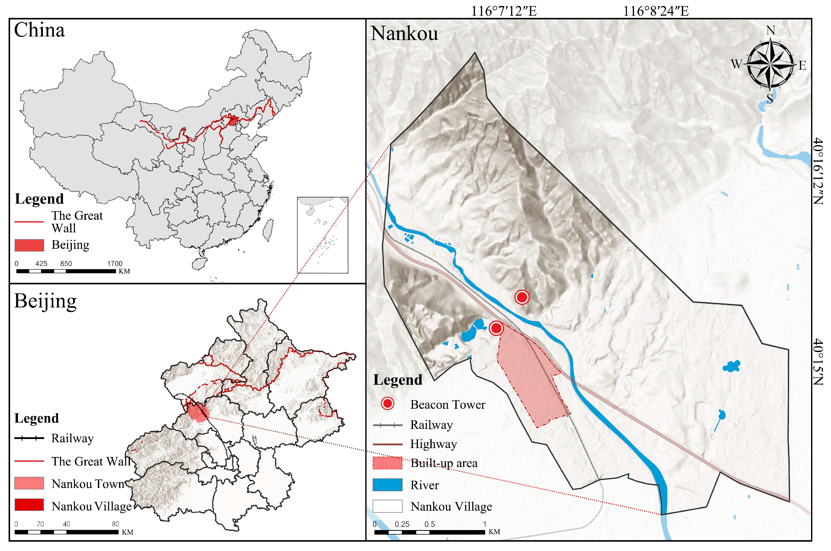
Figure 1. Location Map of Nankou Village.
Land 14 02026 g001
Figure 2. A Bird’s-Eye View of Peiping and Environs, cropped to focus on Nankou (Source: the Beijing Chronicle in 1936).
Land 14 02026 g002
Figure 3. Methodology Diagram.
Land 14 02026 g003
Figure 4. Historical Elements and Village Spatial Patterns at Different Phases.
Land 14 02026 g004
Figure 5. Historical Element Distribution Map of Nankou Village.
Land 14 02026 g005
Figure 6. Spatial Distribution Pattern of Single-Element MGWR Coefficients.
Land 14 02026 g006
Figure 7. Overall Evolution of Nankou Village Morphology under Multi-Factor Coupling.
Land 14 02026 g007
Figure 8. Historical Significance of Nankou.
Land 14 02026 g008
Figure 9. Photos of Nankou Village (The vintage photos from the left was provided by a villager; all other photos were taken by the authors).
Land 14 02026 g009
Figure 10. Modes of Historical Element Conveyance by Physical Space.
Land 14 02026 g010
Figure 11. “History–Space” Inter-construction Mechanism in Nankou Village.
Land 14 02026 g011
Table 1. Sources and Use of Research Data.
TypeDataData SourceProcessing Method
Documentary and Archival MaterialsHistorical DocumentsVarious physical books and the National Library of China Digital CollectionsUsed for the historical background analysis of Nankou Village
Government Planning DocumentsNankou Village Residents’ CommitteeUsed for basic data analysis of land use in Nankou Village
Imagery DataSatellite PhotographsGoogle EarthUsed for village plan analysis; building outlines extracted with CAD
Aerial PhotographsCaptured by researcherUsed for village plan analysis; building outlines extracted with CAD
Spatial Geographic Information DataBuilding data and
Built-environment data such as roads, rivers, railways, and road
Extracted by the author based on satellite and aerial imageryTraced with CAD from satellite and aerial imagery and supplemented with field-survey data
Interview DataOral information recordsVillagers and staff of the Residents’ CommitteeInformal exchanges with villagers and village committee staff
Table 2. Indicators and Calculation Methods for Historical Influences on Spatial Development of Nankou Village.
TypeIndicatorCalculation Method
Dependent VariableBuilding Center Point Kernel Density ValuePerform kernel density analysis for all buildings and assign the resulting values to each building center point
Independent VariablesWall FactorStraight-line distance from building center point to city wall
Gate FactorStraight-line distance from building center point to city gate
Railway FactorStraight-line distance from building center point to railway
Post Road FactorStraight-line distance from building center point to post road
River FactorStraight-line distance from building center point to river center
Elevation FactorElevation height of building center point
Table 3. The results of variance inflation factor (VIF).
Gate FactorWall FactorRailway FactorPost-Road FactorRiver FactorElevation Factor
Tolerance0.1800.6990.6560.1500.4890.130
VIF5.5561.4301.5256.6672.0457.692
Table 4. Statistical Parameters of GWR and MGWR Models.
Model IndicatorGWRMGWR
R20.0710.907
AICc4412.9371040.978
Table 5. Statistical Description of MGWR Model Coefficients.
BandwidthMeanMinimumMedianMaximum
Intercept43.00011.7476.74711.44318.365
Wall Factor43.0001.684−14.0329.81913.031
Railway Factor43.0001.234−9.2171.2238.875
River Factor43.000−4.544−12.457−6.7398.419
Table 6. Joint Display of Quantitative Results and Qualitative Validation.
Historical FactorsQuantitative ResultsQualitative Validation
Wall FactorCoefficient near the wall is positive.
Coefficients outside the South Gate is negative
Ancient military defense.
Railway FactorCoefficient near the station is positive.
Coefficients toward the north is negative
Railway spatial barrier.
Recent commercial prosperity around the station
River FactorCoefficient near water is positive.
Coefficients farther from water is negative
Ancient water supply and irrigation.
Modern riverside interaction and leisure
Disclaimer/Publisher’s Note: The statements, opinions and data contained in all publications are solely those of the individual author(s) and contributor(s) and not of MDPI and/or the editor(s). MDPI and/or the editor(s) disclaim responsibility for any injury to people or property resulting from any ideas, methods, instructions or products referred to in the content.