



Evaluating Sugarcane Yield Estimation in Thailand Using Multi-Temporal Sentinel-2 and Landsat Data Together with Machine-Learning Algorithms

 ,
,  , , ,
, , ,  and
and 
Abstract
1. Introduction
- (i)
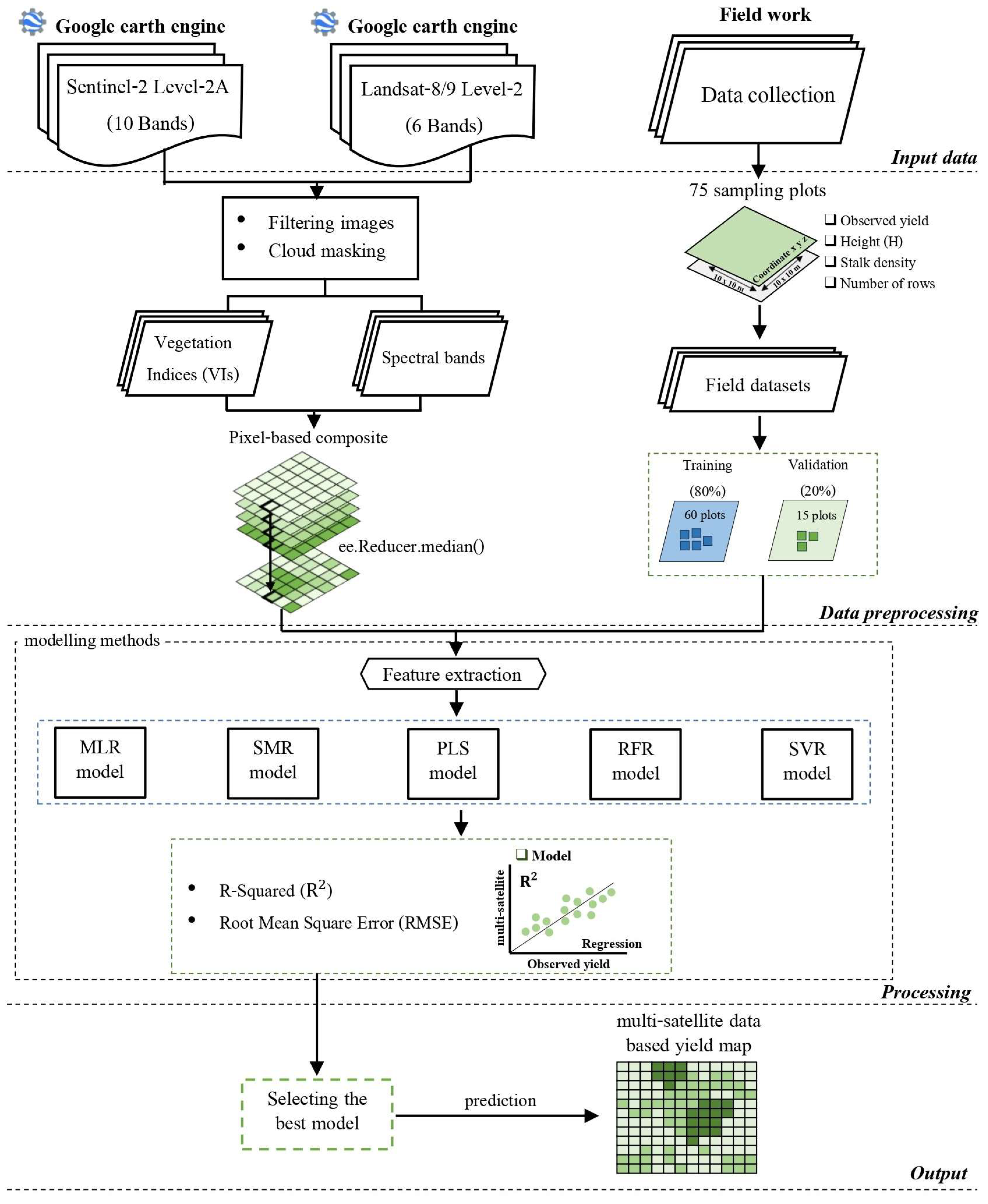
- To evaluate the best machine-learning method for sugarcane yield estimation (e.g., multiple linear regression (MLR), stepwise multiple regression (SMR), partial least squares regression (PLS), RFR and SVR);
- (ii)
- To apply the identified algorithm using joint multi-temporal S2 and L8/9 data to map the estimated sugarcane yield in 2022 within the Tha Khan Tho district of Kalasin province.
2. Materials and Methods
2.1. Study Area
2.2. Field Data Collection
2.3. Satellite Dataset
2.3.1. Sentinel-2 Data
2.3.2. Landsat Data
2.3.3. Vegetation Index Generation
2.4. The Median Compositing Approach
2.5. Sugarcane Yield Estimation
- Multiple Linear Regression (MLR) is a mathematical algorithm that leverages multiple independent variables to derive a predictive value. The MLR model is widely used in several applications across scientific disciplines [39,40]. Their adaptability and robust theoretical underpinnings make MLR an invaluable tool for researchers and practitioners seeking accurate predictions in various scientific contexts (see the details in Formula (1) below). To fit the model, we implemented the “leaps” package in R.
- Stepwise Multiple Regression (SMR) is a multiple linear model designed to incorporate or exclude variables from the regression equation based on their impact on the dependent variable. This facilitates examining linear relationships among multiple variables [41]. Prior investigations have indicated the superiority of the stepwise Akaike Information Criterion (AIC) method for variable selection compared to other stepwise techniques. Consequently, our strategy involved identifying crucial variables by all input datasets, which was guided by the AIC principle [42]. This work utilized the ‘stepwise’ package in R for the implementation, ensuring a comprehensive exploration of variable selection in the MLR model.
- Partial Least Squares Regression (PLSR) is an approach that integrate the principles of principal components analysis (PCA) and multiple linear regression and identifies components from the explanatory (X) variables that are pertinent to the response (Y) variables, reducing the dimensionality of the explanatory variables [43,44]. PLSR solves significant problems such as overfitting, multicollinearity, and outliers, simultaneously identifying factors that elucidate a substantial portion of the information shared between all ‘X’ and ‘Y’ variables [43,45,46]. Specifically, the PLSR process utilizes ‘X’ variables to predict ‘Y’. Incorporating all variables in constructing PLSR factors does not specify which variable or group of variables comparatively contributes more to predicting the ‘Y’ variable [47]. We implemented the PLSR model using the PLS library in the R software [48].
- Random Forest Regression (RFR) is a machine-learning technique introduced by Breiman [49] that leverages multiple decision trees for the classification and regression method. It is renowned for its robust performance, particularly in handling noise in training data and addressing nonlinear problems. RFR involves optimizing two key parameters during model construction: the number of trees (ntree) and the randomly chosen predictor for each node in the binary tree (mtry). The final predictors are derived by averaging the outputs of all regression trees [49]. Our implementation of the RFR model utilized the ‘randomForest’ package in R. Moreover, the RFR model was optimized through a ‘Grid Search’ process to find the best parameter settings. Specifically, the parameters of trees were tuned from 100 to 1500 (at an interval of 50) with entry from 1 to 10 (at the step of 1). The result fitted the best parameters of 500 trees and 3 mtry, resulting in the most excellent hyperparameters.
- Support Vector Regression (SVR) is a kernel-based machine-learning approach proposed by Cortes and Vapnik [50] and further developed by Vapnik [51]. This method typically utilizes a kernel function to transform training datasets into a high-dimensional feature space, enabling the identification of an optimal hyperplane that maximizes the margin between the hyperplane and the nearest positive and negative reference datasets. For the kernel function, we used the radial basis function (RBF). SVR requires two parameters, including cost (c) and gamma values, to determine the most effective configuration for the SVR model. Similar for the RFR model, also in this case, the SVR hyperparameter were optimized. In particular, the c value was set from −1 to 5 (at the interval of 1), and many gamma values were set from 0.1 to 5 (at the step of 1). This analysis resulted in the final optimization of the hyperparameter for the model with c = 1 and gamma = 0.1. Implementation of the SVR model was accomplished using the ‘e1071′ package in R.
2.5.1. Important Feature Selection
2.5.2. Sugarcane Yield Accuracy Evaluation
2.5.3. Sugarcane Yield Mapping
3. Results
3.1. Ranking Important Features
3.2. Sugarcane Yield Modelling
3.3. Estimated Sugarcane Yield Maps
4. Discussion
4.1. Evaluated Performance of Yield Estimation
4.2. Spatial Distribution of Sugarcane Yield Map
4.3. Insight on Sugarcane Crop Management
5. Conclusions
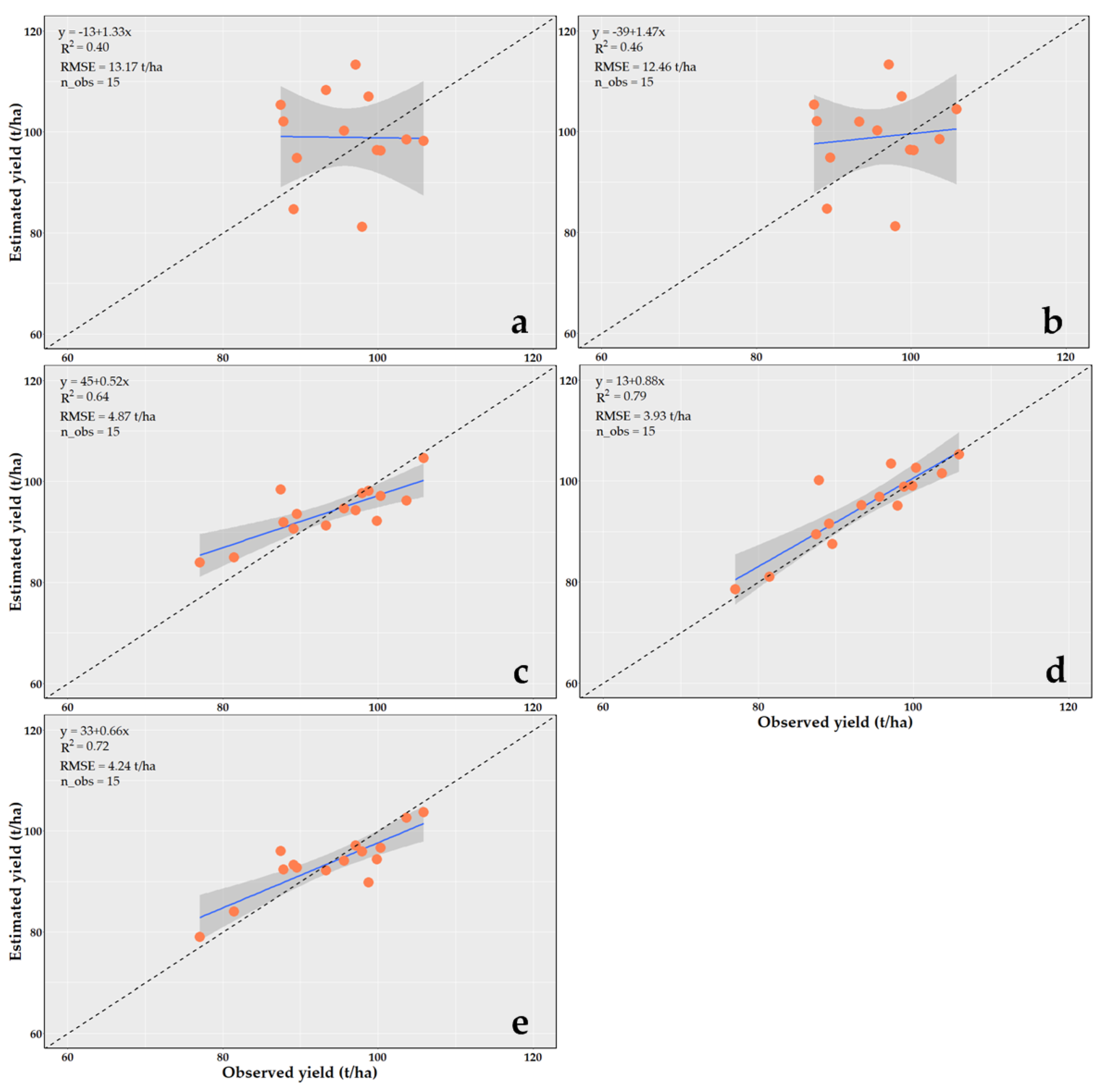
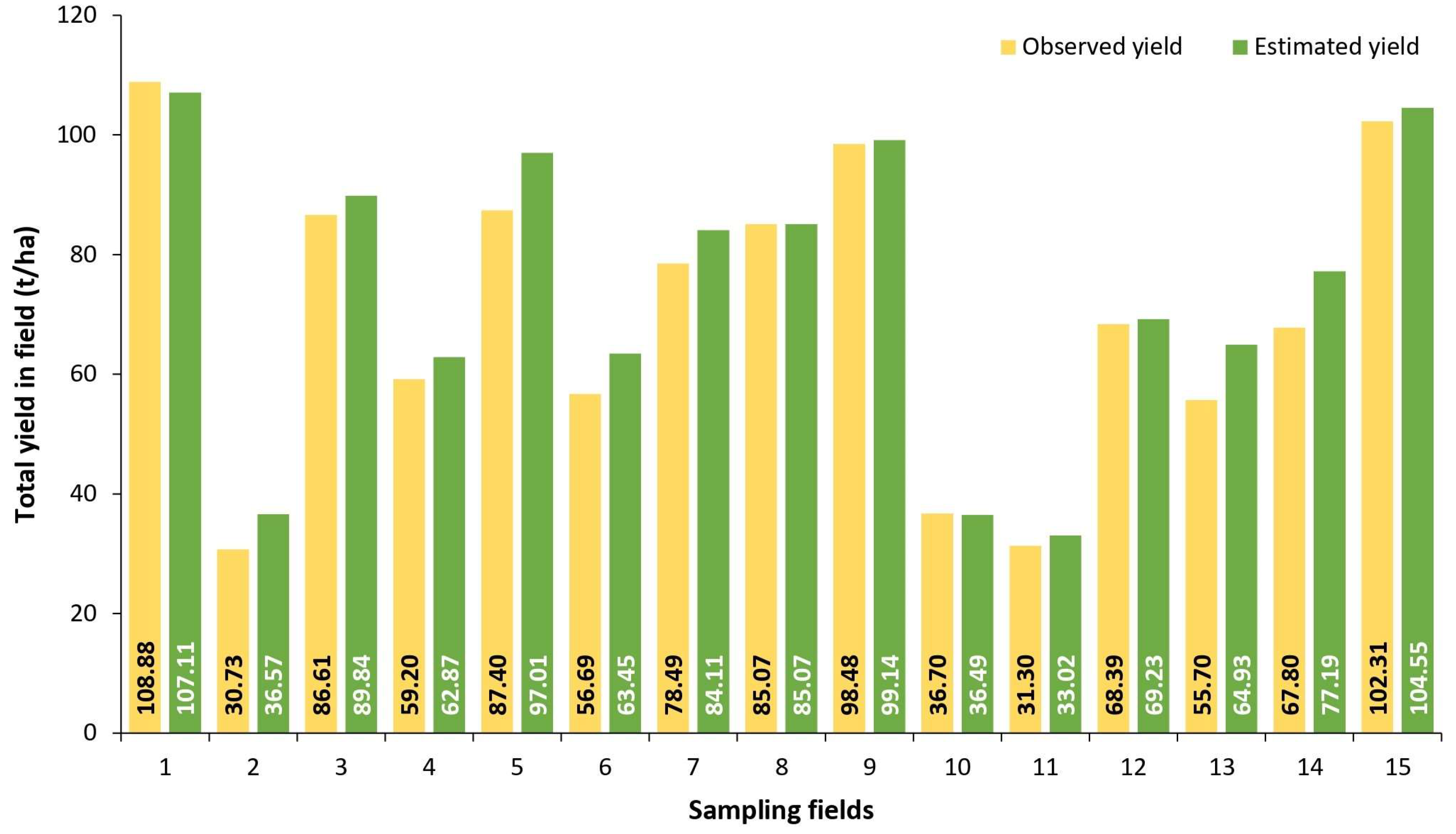
- The random forest regression (RFR) model demonstrated high accuracy in sugarcane yield estimation compared to other predictive models like MLR, SMR, PLS and SVR. The RFR model proved particularly effective in smallholder crop systems and regions with persistent cloud cover, such as Thailand’s northeast. It achieve an R2 of 0.79 and an RMSE of 3.93 t/ha;
- This study evaluated machine-learning performance for sugarcane yield estimation using a limited samples size (60 sampling plots) due to cost and time constraints. Despite the small dataset, the RFR model achieved highly accurate results for mapping sugarcane yield in small field sizes (<1 ha) and complex landscapes;
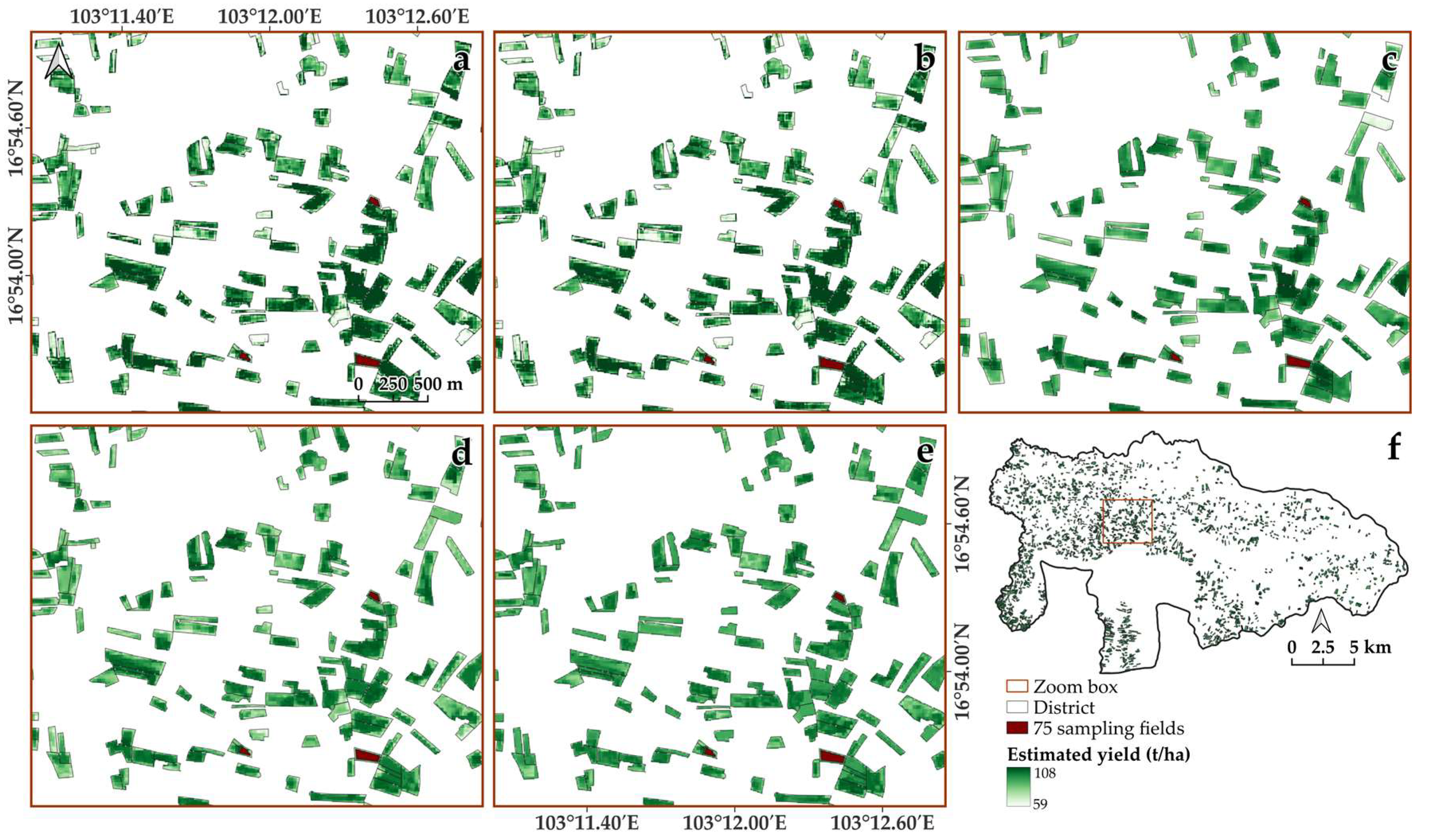
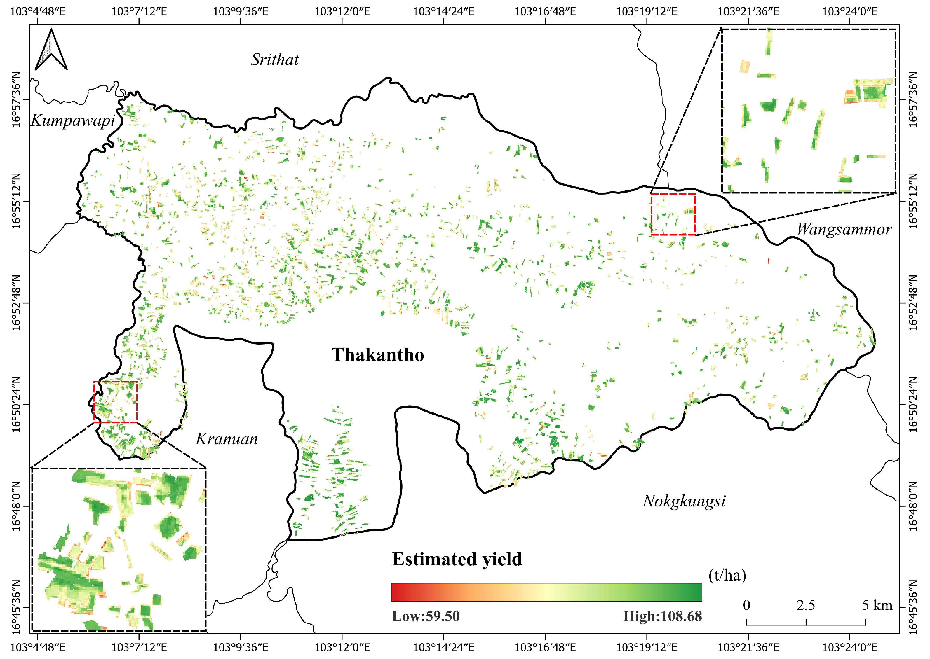
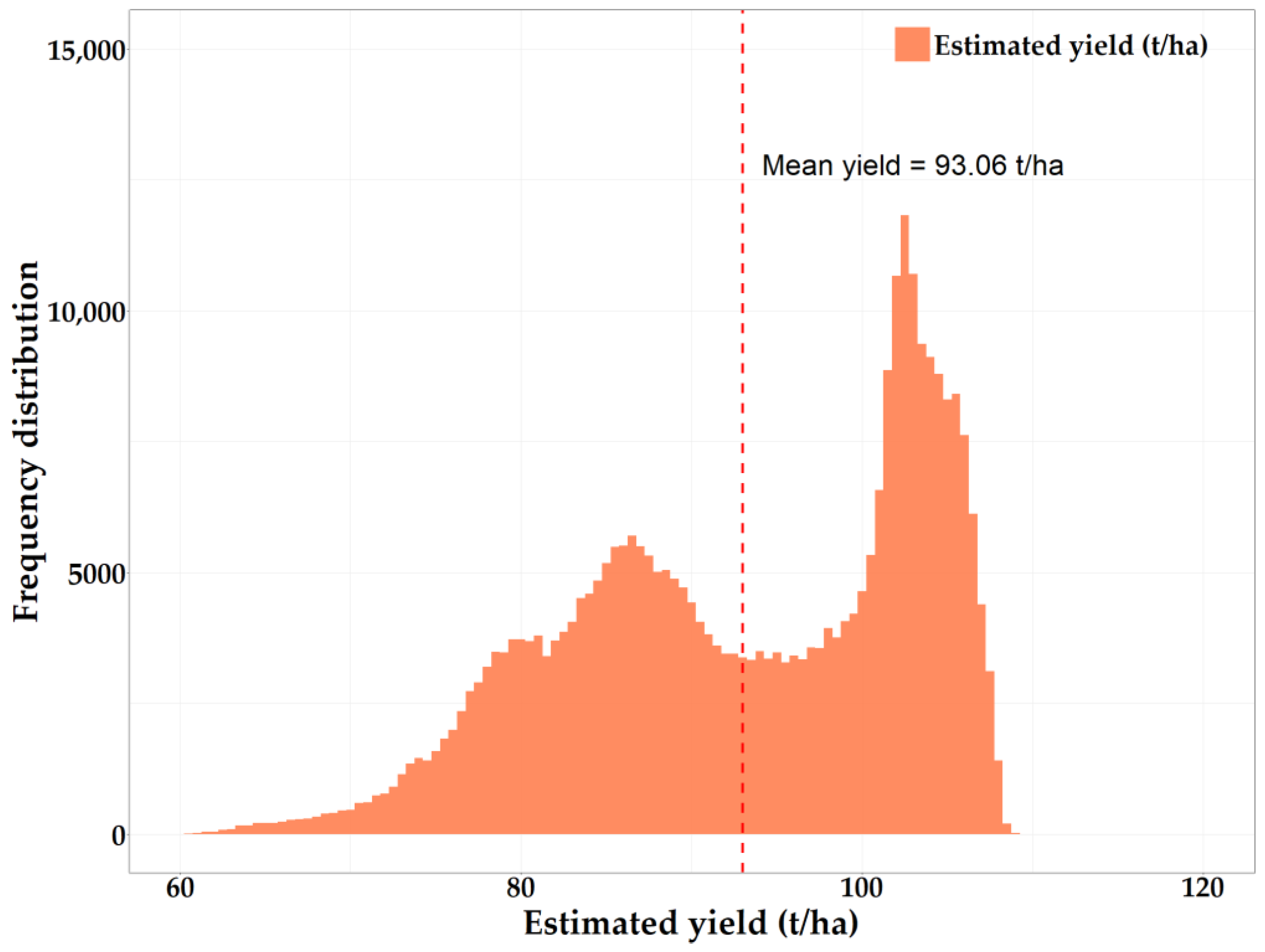
- Variability in sugarcane yield within fields was observed with results showing smooth and evenly distributed yield estimates across the region. The average estimated yield was 93.06 t/ha with a standard deviation (SD) of 10.25 t/ha;
- The RFR method, even with a limited ground dataset, showed efficiency in mapping sugarcane fields;
- The high accuracy of yield estimates at the field level provides valuable information for local farmers and stakeholders, aiding in the understanding of crop conditions and the optimizing fertilizer and irrigation practices. This approach to sugarcane yield mapping represents a significant advancement in smart agriculture for Thailand, offering farmers actionable insights to enhance productivity, profitability and environmental management.
Author Contributions
Funding
Data Availability Statement
Acknowledgments
Conflicts of Interest
References
- Barbosa Júnior, M.R.; Tedesco, D.; Corrêa, R.d.G.; Moreira, B.R.d.A.; Silva, R.P.d.; Zerbato, C. Mapping gaps in sugarcane by UAV RGB imagery: The lower and earlier the flight, the more accurate. Agronomy 2021, 11, 2578. [Google Scholar] [CrossRef] [Scilit]
- Momin, M.A.; Grift, T.E.; Valente, D.S.; Hansen, A.C. Sugarcane yield mapping based on vehicle tracking. Precis. Agric. 2019, 20, 896–910. [Google Scholar] [CrossRef] [Scilit]
- Molin, J.P.; Veiga, J.P.S. Spatial variability of sugarcane row gaps: Measurement and mapping. Cienc. Agrotec. 2016, 40, 347–355. [Google Scholar] [CrossRef] [Scilit]
- Birrell, S.J.; Sudduth, K.A.; Borgelt, S.C. Comparison of sensors and techniques for crop yield mapping. Comput. Electron. Agric. 1996, 14, 215–233. [Google Scholar] [CrossRef] [Scilit]
- Bégué, A.; Lebourgeois, V.; Bappel, E.; Todoroff, P.; Pellegrino, A.; Baillarin, F.; Siegmund, B. Spatio-temporal variability of sugarcane fields and recommendations for yield forecast using NDVI. Int. J. Remote Sens. 2010, 31, 5391–5407. [Google Scholar] [CrossRef] [Scilit]
- Palaniswami, C.; Gopalasundaram, P.; Bhaskaran, A. Application of GPS and GIS in Sugarcane Agriculture. Sugar Tech 2011, 13, 360–365. [Google Scholar] [CrossRef] [Scilit]
- Noureldin, N.; Aboelghar, M.; Saudy, H.; Ali, A. Rice yield forecasting models using satellite imagery in Egypt. Egypt. J. Remote Sens. Space Sci. 2013, 16, 125–131. [Google Scholar] [CrossRef] [Scilit]
- FAO. Food and Agriculture Organization of the United Nations. Available online: https://www.fao.org/faostat/en/?#data/QCL (accessed on 13 April 2024).
- Sriroth, K.; Vanichsriratana, W.; Sunthornvarabhas, J. The current status of sugar industry and by-products in Thailand. Sugar Tech 2016, 18, 576–582. [Google Scholar] [CrossRef] [Scilit]
- Office of the Cane & Sugar Board. Documentation Detailing the Status of Sugarcane Cultivation during the Production Year 2022/23; Office of The Cane and Sugar Board: Bangkok, Thailand, 2023. [Google Scholar]
- Som-Ard, J.; Atzberger, C.; Izquierdo-Verdiguier, E.; Vuolo, F.; Immitzer, M. Remote sensing applications in sugarcane cultivation: A review. Remote Sens. 2021, 13, 4040. [Google Scholar] [CrossRef] [Scilit]
- Chunhawong, K.; Chaisan, T.; Rungmekarat, S.; Khotavivattana, S. Sugar industry and utilization of its by-products in Thailand: An overview. Sugar Tech 2018, 20, 111–115. [Google Scholar] [CrossRef] [Scilit]
- Som-ard, J.; Immitzer, M.; Vuolo, F.; Atzberger, C. Sugarcane yield estimation in Thailand at multiple scales using the integration of UAV and Sentinel-2 imagery. Precis. Agric. 2024, 25, 1581–1608. [Google Scholar] [CrossRef] [Scilit]
- Suwanlee, S.R.; Pinasu, D.; Som-ard, J.; Borgogno-Mondino, E.; Sarvia, F. Estimating Sugarcane Aboveground Biomass and Carbon Stock Using the Combined Time Series of Sentinel Data with Machine Learning Algorithms. Remote Sens. 2024, 16, 750. [Google Scholar] [CrossRef] [Scilit]
- Canata, T.F.; Wei, M.C.F.; Maldaner, L.F.; Molin, J.P. Sugarcane yield mapping using high-resolution imagery data and machine learning technique. Remote Sens. 2021, 13, 232. [Google Scholar] [CrossRef] [Scilit]
- Shendryk, Y.; Davy, R.; Thorburn, P. Integrating satellite imagery and environmental data to predict field-level cane and sugar yields in Australia using machine learning. Field Crops Res. 2021, 260, 107984. [Google Scholar] [CrossRef] [Scilit]
- Weiss, M.; Jacob, F.; Duveiller, G. Remote sensing for agricultural applications: A meta-review. Remote Sens. Environ. 2020, 236, 111402. [Google Scholar] [CrossRef] [Scilit]
- Atzberger, C. Advances in remote sensing of agriculture: Context description, existing operational monitoring systems and major information needs. Remote Sens. 2013, 5, 949–981. [Google Scholar] [CrossRef] [Scilit]
- de França e Silva, N.R.; Chaves, M.E.D.; Luciano, A.C.d.S.; Sanches, I.D.A.; de Almeida, C.M.; Adami, M. Sugarcane Yield Estimation Using Satellite Remote Sensing Data in Empirical or Mechanistic Modeling: A Systematic Review. Remote Sens. 2024, 16, 863. [Google Scholar] [CrossRef] [Scilit]
- Rahman, M.M.; Robson, A. Integrating landsat-8 and sentinel-2 time series data for yield prediction of sugarcane crops at the block level. Remote Sens. 2020, 12, 1313. [Google Scholar] [CrossRef] [Scilit]
- Abebe, G.; Tadesse, T.; Gessesse, B. Combined use of Landsat 8 and Sentinel 2A imagery for improved sugarcane yield estimation in Wonji-Shoa, Ethiopia. J. Indian. Soc. Remote Sens. 2022, 50, 143–157. [Google Scholar] [CrossRef] [Scilit]
- Dimov, D.; Uhl, J.H.; Löw, F.; Seboka, G.N. Sugarcane yield estimation through remote sensing time series and phenology metrics. Smart Agric. Technol. 2022, 2, 100046. [Google Scholar] [CrossRef] [Scilit]
- Louis, J.; Debaecker, V.; Pflug, B.; Main-Knorn, M.; Bieniarz, J.; Mueller-Wilm, U.; Cadau, E.; Gascon, F. Sentinel-2 Sen2Cor: L2A processor for users. In Proceedings of the ‘Living Planet Symposium 2016’, Prague, Czech Republic, 9–13 May 2016; pp. 1–8. [Google Scholar]
- Som-ard, J. Rice security assessment using geo-spatial analysis. Int. J. Geoinform. 2020, 16, 21–38. [Google Scholar]
- Suwanlee, S.R.; Keawsomsee, S.; Pengjunsang, M.; Homtong, N.; Prakobya, A.; Borgogno-Mondino, E.; Sarvia, F.; Som-ard, J. Monitoring Agricultural Land and Land Cover Change from 2001–2021 of the Chi River Basin, Thailand Using Multi-Temporal Landsat Data Based on Google Earth Engine. Remote Sens. 2023, 15, 4339. [Google Scholar] [CrossRef] [Scilit]
- Rouse, J.W.; Haas, R.H.; Schell, J.A.; Deering, D.W. Monitoring vegetation systems in the Great Plains with ERTS. NASA Spec. Publ. 1974, 351, 309. [Google Scholar]
- Serrano, L.; Ustin, S.L.; Roberts, D.A.; Gamon, J.A.; Penuelas, J. Deriving water content of chaparral vegetation from AVIRIS data. Remote Sens. Environ. 2000, 74, 570–581. [Google Scholar] [CrossRef] [Scilit]
- Huete, A.; Didan, K.; Miura, T.; Rodriguez, E.P.; Gao, X.; Ferreira, L.G. Overview of the radiometric and biophysical performance of the MODIS vegetation indices. Remote Sens. Environ. 2002, 83, 195–213. [Google Scholar] [CrossRef] [Scilit]
- Klemas, V.; Smart, R. The influence of soil salinity, growth form, and leaf moisture on the spectral radiance of Spartina Alterniflora canopies. Photogramm. Eng. Remote Sens. 1983, 49, 77–83. [Google Scholar]
- Gitelson, A.A.; Kaufman, Y.J.; Merzlyak, M.N. Use of a green channel in remote sensing of global vegetation from EOS-MODIS. Remote Sens. Environ. 1996, 58, 289–298. [Google Scholar] [CrossRef] [Scilit]
- Huete, A.R. A soil-adjusted vegetation index (SAVI). Remote Sens. Environ. 1988, 25, 295–309. [Google Scholar] [CrossRef] [Scilit]
- Kaufman, Y.J.; Tanre, D. Atmospherically resistant vegetation index (ARVI) for EOS-MODIS. IEEE Trans. Geosci. Remote Sens. 1992, 30, 261–270. [Google Scholar] [CrossRef] [Scilit]
- Jin, S.; Sader, S.A. Comparison of time series tasseled cap wetness and the normalized difference moisture index in detecting forest disturbances. Remote Sens. Environ. 2005, 94, 364–372. [Google Scholar] [CrossRef] [Scilit]
- Wilson, E.H.; Sader, S.A. Detection of forest harvest type using multiple dates of Landsat TM imagery. Remote Sens. Environ. 2002, 80, 385–396. [Google Scholar] [CrossRef] [Scilit]
- Cihlar, J.; Manak, D.; D’Iorio, M. Evaluation of compositing algorithms for AVHRR data over land. IEEE Trans. Geosci. Remote Sens. 1994, 32, 427–437. [Google Scholar] [CrossRef] [Scilit]
- Griffiths, P.; van der Linden, S.; Kuemmerle, T.; Hostert, P. A pixel-based Landsat compositing algorithm for large area land cover mapping. IEEE J. Sel. Top. Appl. Earth Obs. Remote Sens. 2013, 6, 2088–2101. [Google Scholar] [CrossRef] [Scilit]
- White, J.C.; Wulder, M.; Hobart, G.; Luther, J.; Hermosilla, T.; Griffiths, P.; Coops, N.; Hall, R.; Hostert, P.; Dyk, A. Pixel-based image compositing for large-area dense time series applications and science. Can. J. Remote Sens. 2014, 40, 192–212. [Google Scholar] [CrossRef] [Scilit]
- Maxwell, S.K.; Sylvester, K.M. Identification of “ever-cropped” land (1984–2010) using Landsat annual maximum NDVI image composites: Southwestern Kansas case study. Remote Sens. Environ. 2012, 121, 186–195. [Google Scholar] [CrossRef] [Scilit]
- Araiza-Aguilar, J.; Rojas-Valencia, M.; Aguilar-Vera, R. Forecast generation model of municipal solid waste using multiple linear regression. Glob. J. Environ. Sci. Manag. 2020, 6, 1–14. [Google Scholar]
- Abrougui, K.; Gabsi, K.; Mercatoris, B.; Khemis, C.; Amami, R.; Chehaibi, S. Prediction of organic potato yield using tillage systems and soil properties by artificial neural network (ANN) and multiple linear regressions (MLR). Soil. Till. Res. 2019, 190, 202–208. [Google Scholar] [CrossRef] [Scilit]
- Xu, K.; Su, Y.; Liu, J.; Hu, T.; Jin, S.; Ma, Q.; Zhai, Q.; Wang, R.; Zhang, J.; Li, Y. Estimation of degraded grassland aboveground biomass using machine learning methods from terrestrial laser scanning data. Ecol. Indic. 2020, 108, 105747. [Google Scholar] [CrossRef] [Scilit]
- Yamashita, T.; Yamashita, K.; Kamimura, R. A stepwise AIC method for variable selection in linear regression. Commun. Stat.—Theory Methods 2007, 36, 2395–2403. [Google Scholar] [CrossRef] [Scilit]
- Abdi, H. Partial least square regression (PLS regression). Encycl. Res. Methods Soc. Sci. 2003, 6, 792–795. [Google Scholar]
- Wold, S.; Trygg, J.; Berglund, A.; Antti, H. Some recent developments in PLS modeling. Chemom. Intell. Lab. Syst. 2001, 58, 131–150. [Google Scholar] [CrossRef] [Scilit]
- Huang, Z.; Turner, B.J.; Dury, S.J.; Wallis, I.R.; Foley, W.J. Estimating foliage nitrogen concentration from HYMAP data using continuum removal analysis. Remote Sens. Environ. 2004, 93, 18–29. [Google Scholar] [CrossRef] [Scilit]
- Hubert, M.; Branden, K.V. Robust methods for partial least squares regression. J. Chemom. 2003, 17, 537–549. [Google Scholar] [CrossRef] [Scilit]
- Chun, H.; Keleş, S. Sparse partial least squares regression for simultaneous dimension reduction and variable selection. J. R. Stat. 2010, 72, 3–25. [Google Scholar] [CrossRef] [Scilit] [PubMed]
- Abdel-Rahman, E.M.; Mutanga, O.; Odindi, J.; Adam, E.; Odindo, A.; Ismail, R. A comparison of partial least squares (PLS) and sparse PLS regressions for predicting yield of Swiss chard grown under different irrigation water sources using hyperspectral data. Comput. Electron. Agric. 2014, 106, 11–19. [Google Scholar] [CrossRef] [Scilit]
- Breiman, L. Random forests. Mach. Learn. 2001, 45, 5–32. [Google Scholar] [CrossRef] [Scilit]
- Cortes, C.; Vapnik, V. Support-vector networks. Mach. Learn. 1995, 20, 273–297. [Google Scholar] [CrossRef] [Scilit]
- Vapnik, V. The Nature of Statistical Learning Theory; Springer: New York, NY, USA, 1995; Volume 10, pp. 123–160. [Google Scholar]
- Xu, J.-X.; Ma, J.; Tang, Y.-N.; Wu, W.-X.; Shao, J.-H.; Wu, W.-B.; Wei, S.-Y.; Liu, Y.-F.; Wang, Y.-C.; Guo, H.-Q. Estimation of sugarcane yield using a machine learning approach based on uav-lidar data. Remote Sens. 2020, 12, 2823. [Google Scholar] [CrossRef] [Scilit]
- Jeong, J.H.; Resop, J.P.; Mueller, N.D.; Fleisher, D.H.; Yun, K.; Butler, E.E.; Timlin, D.J.; Shim, K.-M.; Gerber, J.S.; Reddy, V.R. Random forests for global and regional crop yield predictions. PLoS ONE 2016, 11, e0156571. [Google Scholar] [CrossRef] [Scilit]
- Sakamoto, T. Incorporating environmental variables into a MODIS-based crop yield estimation method for United States corn and soybeans through the use of a random forest regression algorithm. ISPRS J. Photogramm. Remote Sens. 2020, 160, 208–228. [Google Scholar] [CrossRef] [Scilit]
- Morel, J.; Todoroff, P.; Bégué, A.; Bury, A.; Martiné, J.-F.; Petit, M. Toward a satellite-based system of sugarcane yield estimation and forecasting in smallholder farming conditions: A case study on Reunion Island. Remote Sens. 2014, 6, 6620–6635. [Google Scholar] [CrossRef] [Scilit]
- Rahman, M.M.; Robson, A.J. A novel approach for sugarcane yield prediction using landsat time series imagery: A case study on Bundaberg region. Adv. Remote Sens. 2016, 5, 93–102. [Google Scholar] [CrossRef]
- Sharifi, A. Yield prediction with machine learning algorithms and satellite images. J. Sci. Food. Agric. 2021, 101, 891–896. [Google Scholar] [CrossRef] [Scilit] [PubMed]
- Sawaengsak, W.; Gheewala, S.H. Analysis of social and socio-economic impacts of sugarcane production: A case study in Nakhon Ratchasima province of Thailand. J. Clean. Prod. 2017, 142, 1169–1175. [Google Scholar] [CrossRef] [Scilit]
- Department of Agricultural Extension. Sugar Cane Production. Available online: https://esc.doae.go.th/ (accessed on 12 April 2024).
- Burney, J.A.; Davis, S.J.; Lobell, D.B. Greenhouse gas mitigation by agricultural intensification. Proc. Natl. Acad. Sci. USA 2010, 107, 12052–12057. [Google Scholar] [CrossRef] [Scilit]
- Kropp, I.; Nejadhashemi, A.P.; Deb, K.; Abouali, M.; Roy, P.C.; Adhikari, U.; Hoogenboom, G. A multi-objective approach to water and nutrient efficiency for sustainable agricultural intensification. Agric. Syst. 2019, 173, 289–302. [Google Scholar] [CrossRef] [Scilit]

| Year | n (10 m × 10 m) | Minimum (t/ha) | Median (t/ha) | Standard Deviation (t/ha) | Mean (t/ha) | Maximum (t/ha) |
|---|---|---|---|---|---|---|
| 2022 | 75 | 43.75 | 100.00 | 12.45 | 96.00 | 112.50 |
| Index | Formula | Reference |
|---|---|---|
| Normalized Difference Vegetation Index (NDVI) | NDVI = | [26] |
| Maximum Normalized Difference Vegetation Index (MaxNDVI) | MaxNDVI = max{NDVI(i,j)1, NDVI(i,j)2,…,NDV(i,j)n} | [35] |
| Green Normalized Difference Vegetation Index (GNDVI) | GNDVI = | [30] |
| Normalized Difference Water Index (NDWI) | NDWI = | [27] |
| Enhanced Vegetation Index (EVI) | EVI = | [28] |
| Normalized Difference Infrared Index (NDII) | NDII = | [29] |
| Soil-Adjusted Vegetation Index (SAVI) | SAVI = (L+1) | [31] |
| Ratio Vegetation Index (RVI) | RVI = | [32] |
| Moisture Index (MSI) | MSI = | [34] |
| Statistics | Methods | ||||
|---|---|---|---|---|---|
| MLR | SMR | PLS | RFR | SVR | |
| R2 | 0.40 | 0.46 | 0.64 | 0.79 | 0.72 |
| MSE (t/ha)2 | 173.41 | 159.75 | 23.71 | 15.42 | 17.99 |
| RMSE (t/ha) | 13.17 | 12.64 | 4.87 | 3.93 | 4.24 |
Disclaimer/Publisher’s Note: The statements, opinions and data contained in all publications are solely those of the individual author(s) and contributor(s) and not of MDPI and/or the editor(s). MDPI and/or the editor(s) disclaim responsibility for any injury to people or property resulting from any ideas, methods, instructions or products referred to in the content. |
© 2024 by the authors. Licensee MDPI, Basel, Switzerland. This article is an open access article distributed under the terms and conditions of the Creative Commons Attribution (CC BY) license (https://creativecommons.org/licenses/by/4.0/).
Share and Cite
Som-ard, J.; Suwanlee, S.R.; Pinasu, D.; Keawsomsee, S.; Kasa, K.; Seesanhao, N.; Ninsawat, S.; Borgogno-Mondino, E.; Sarvia, F. Evaluating Sugarcane Yield Estimation in Thailand Using Multi-Temporal Sentinel-2 and Landsat Data Together with Machine-Learning Algorithms. Land 2024, 13, 1481. https://doi.org/10.3390/land13091481
Som-ard J, Suwanlee SR, Pinasu D, Keawsomsee S, Kasa K, Seesanhao N, Ninsawat S, Borgogno-Mondino E, Sarvia F. Evaluating Sugarcane Yield Estimation in Thailand Using Multi-Temporal Sentinel-2 and Landsat Data Together with Machine-Learning Algorithms. Land. 2024; 13(9):1481. https://doi.org/10.3390/land13091481
Chicago/Turabian StyleSom-ard, Jaturong, Savittri Ratanopad Suwanlee, Dusadee Pinasu, Surasak Keawsomsee, Kemin Kasa, Nattawut Seesanhao, Sarawut Ninsawat, Enrico Borgogno-Mondino, and Filippo Sarvia. 2024. "Evaluating Sugarcane Yield Estimation in Thailand Using Multi-Temporal Sentinel-2 and Landsat Data Together with Machine-Learning Algorithms" Land 13, no. 9: 1481. https://doi.org/10.3390/land13091481
APA StyleSom-ard, J., Suwanlee, S. R., Pinasu, D., Keawsomsee, S., Kasa, K., Seesanhao, N., Ninsawat, S., Borgogno-Mondino, E., & Sarvia, F. (2024). Evaluating Sugarcane Yield Estimation in Thailand Using Multi-Temporal Sentinel-2 and Landsat Data Together with Machine-Learning Algorithms. Land, 13(9), 1481. https://doi.org/10.3390/land13091481

