The Spatial-Temporal Patterns and Driving Mechanisms of the Ecological Barrier Transition Zone in the Western Jilin, China
Abstract
1. Introduction
2. Materials and Methods
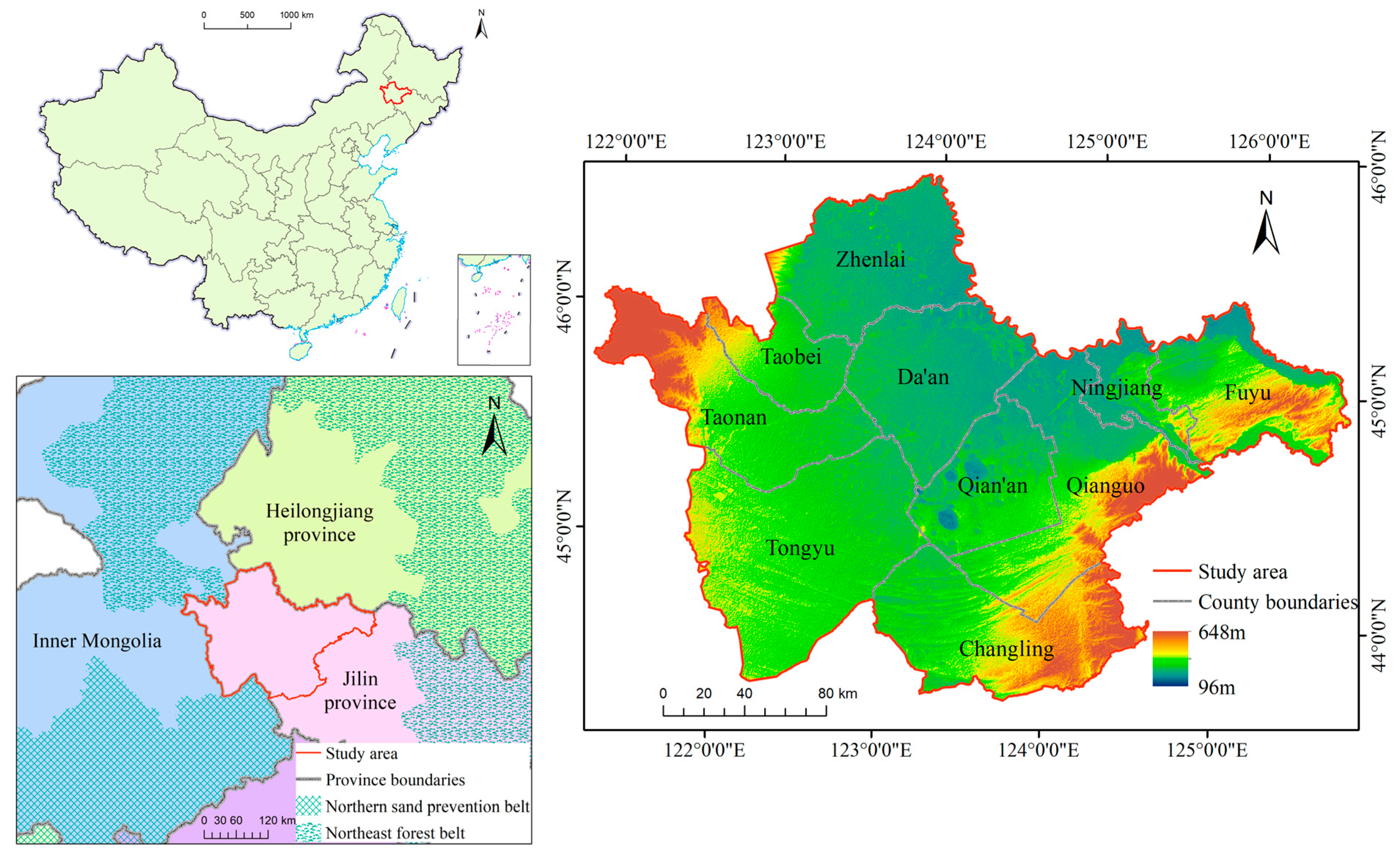
2.1. Study Area
2.2. Data and Preprocessing
| Code of Factor | Dataset | Year | Initial Resolution | Sources | |
|---|---|---|---|---|---|
| 1 | - | Land use data | 1990, 2000, 2010, 2020 | 1″ | Resource and Environment Science and Data Center (https://www.resdc.cn, accessed on 28 February 2024) |
| 2 | X1 | DEM | 1990, 2020 | 30″ | Global Climate and Weather Database (https://worldclim.org/data/index.html, accessed on 28 February 2024) |
| 3 | X2 | Slope | 1990, 2020 | 30″ | Calculate from DEM |
| 4 | X3 | Aspect | 1990, 2020 | 30″ | Calculate from DEM |
| 5 | X4 | Annual rainfall | 1990, 2020 | 1° | Global Rainfall Climatology Centre dataset [38] |
| 6 | X5 | Average annual temperature | 1990, 2020 | 30″ | Global Climate and Weather Database (https://worldclim.org/data/index.html, accessed on 28 February 2024) |
| 7 | X6 | Soil moisture | 1990, 2020 | 15′ | Plant Science Data Center (https://www.plantplus.cn/doi/doi.org/10.6084, accessed on 25 May 2024) |
| 8 | X7 | Aridity index | 1990, 2020 | 30″ | Science Data Bank (https://www.scidb.cn/, accessed on 25 May 2024) |
| 9 | X8 | GDP | 1990, 2020 | - | China Statistical Yearbooks (http://www.stats.gov.cn/, accessed on 28 February 2024) Jilin Statistical Yearbook (http://tjj.jl.gov.cn/index.html, accessed on 28 February 2024) |
| 10 | X9 | Population size | 1990, 2020 | - | |
| 11 | X10 | Agricultural population size | 1990, 2020 | - | |
| 12 | X11 | Livestock population | 1990, 2020 | - | |
| 13 | X12 | Urbanization level | 1990, 2020 | - | |
| 14 | - | Relevant policies | 1990–2020 | - |
2.3. Methods
2.3.1. Land-Use Change Index
2.3.2. Land-Use Transfer Matrix and Trajectories
2.3.3. Driving Factors Detection
3. Results
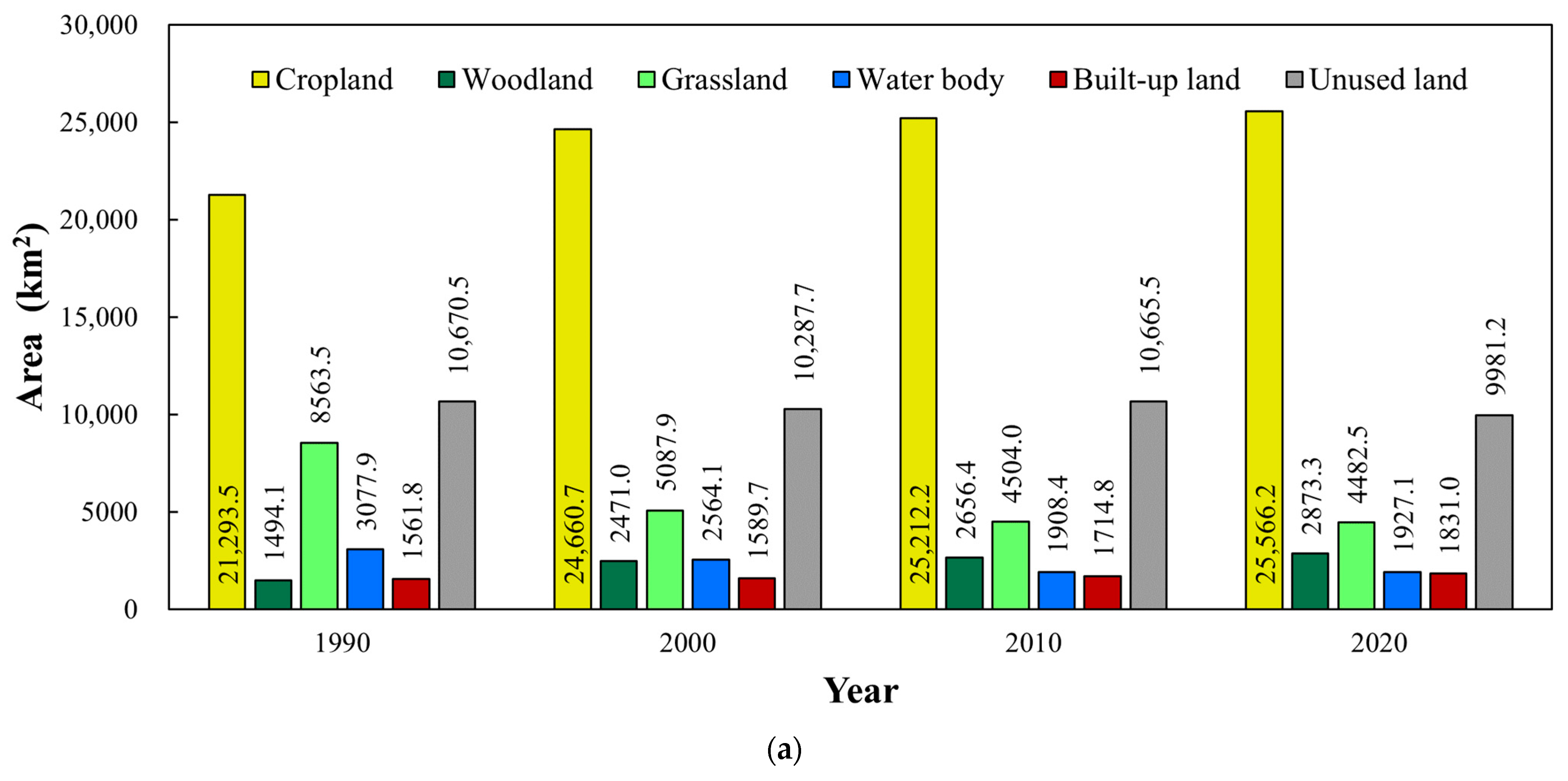
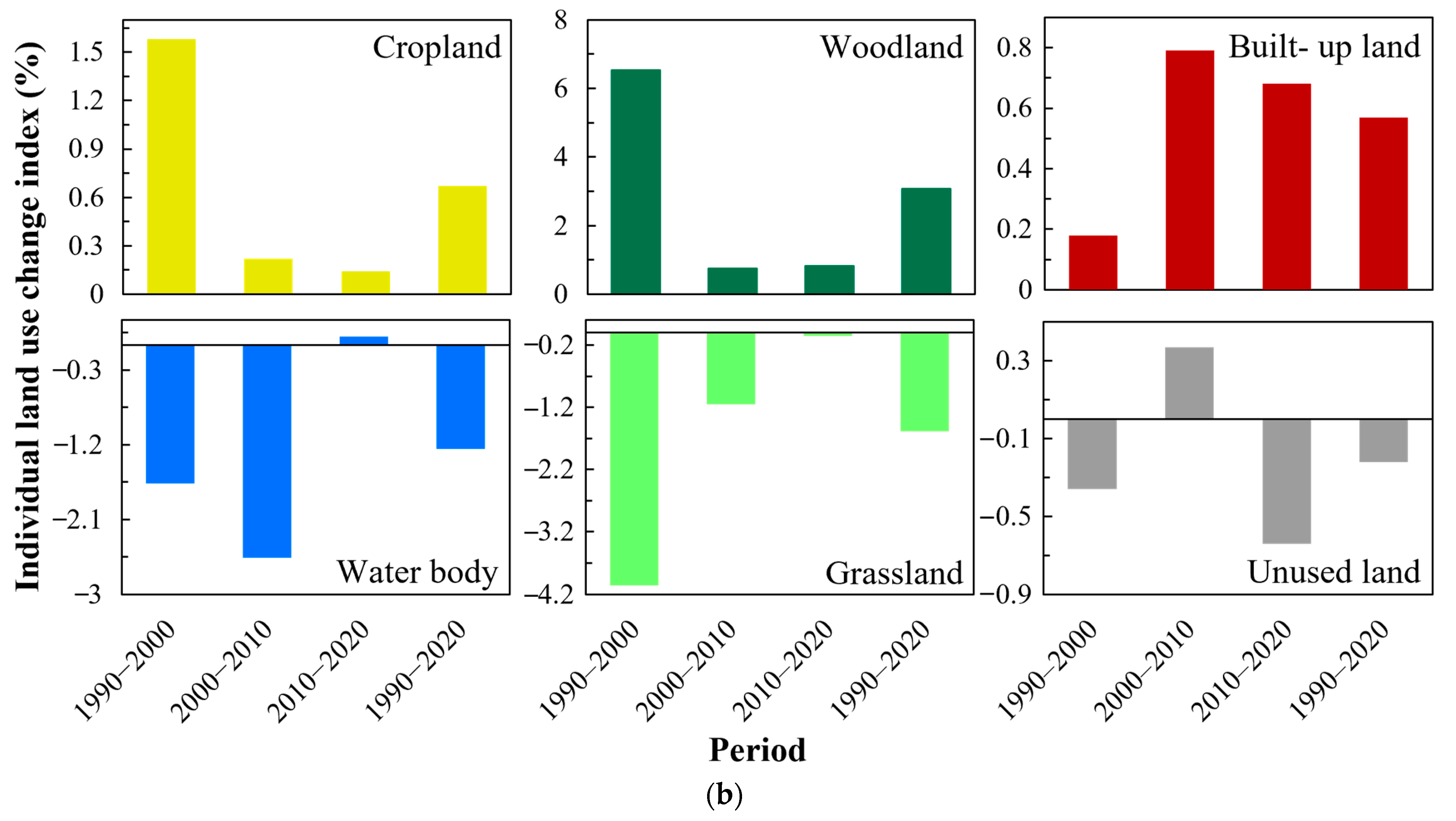
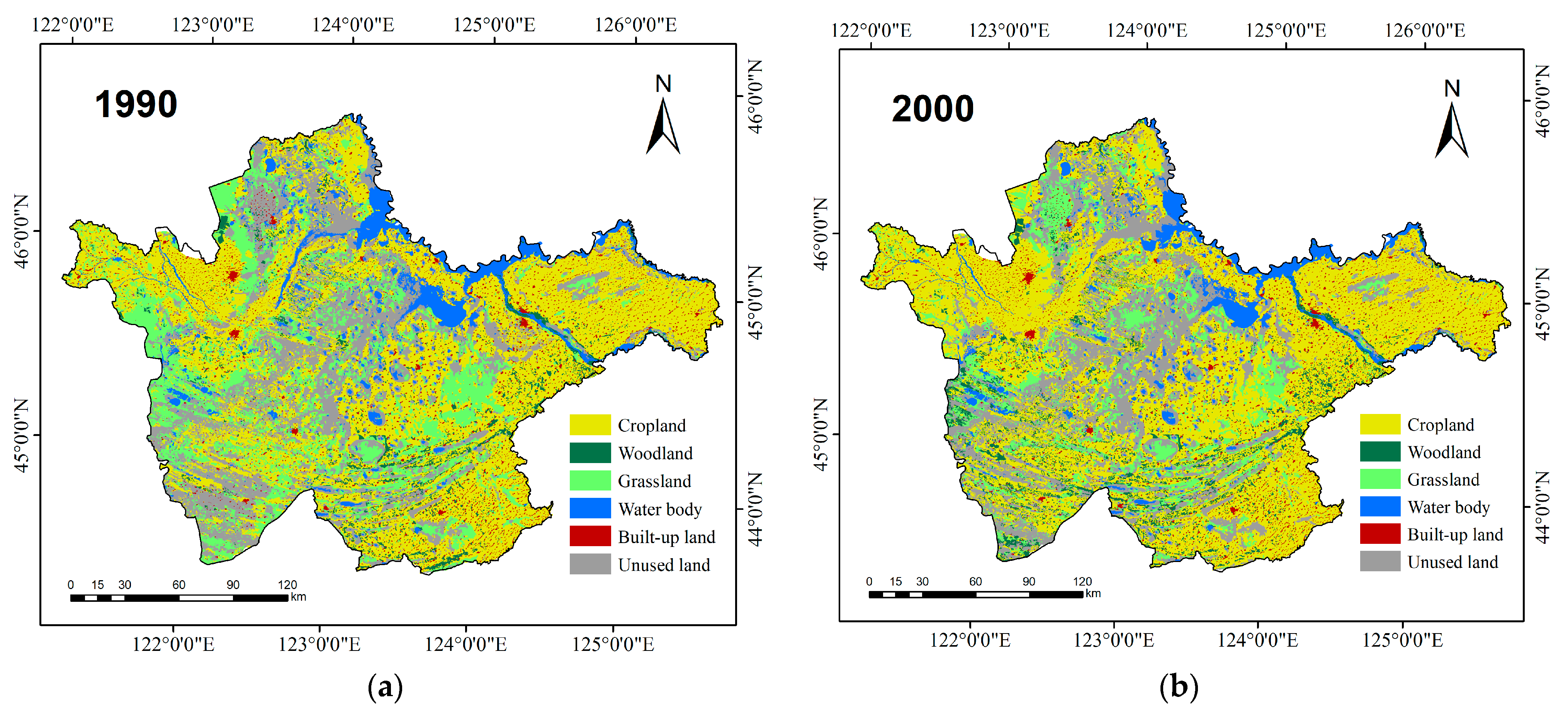
3.1. Spatiotemporal Variation Analysis
3.2. Type Conversion Characteristics
3.3. Topographic-Climatic-Economic Factors
3.3.1. Factor Detection
3.3.2. Interaction Detection
3.3.3. Risk Detection
3.4. Policy Factors
4. Discussion
5. Conclusions
Author Contributions
Funding
Data Availability Statement
Acknowledgments
Conflicts of Interest
References
- Colglazier, W. Sustainable development agenda: 2030. Science 2015, 349, 1048–1050. [Google Scholar] [CrossRef] [PubMed]
- Brito, L. Analyzing Sustainable Development Goals. Science 2012, 336, 1396. [Google Scholar] [CrossRef] [PubMed]
- Fan, J. Draft of major function oriented zoning of China. Acta Geogr. Sin. 2015, 70, 186–201. (In Chinese) [Google Scholar] [CrossRef]
- Fu, B. Several key points in territorial ecological restoration. Bull. Chin. Acad. Sci. 2021, 36, 64–69. (In Chinese) [Google Scholar] [CrossRef]
- Su, Y.-Z.; Zhao, H.-L.; Zhang, T.-H.; Zhao, X.-Y. Soil properties following cultivation and non-grazing of a semi-arid sandy grassland in northern China. Soil Tillage Res. 2004, 75, 27–36. [Google Scholar] [CrossRef]
- Piao, S.L.; Liu, Q.; Chen, A.P.; Janssens, I.A.; Fu, Y.S.; Dai, J.H.; Liu, L.L.; Lian, X.; Shen, M.G.; Zhu, X.L. Plant phenology and global climate change: Current progresses and challenges. Glob. Chang. Biol. 2019, 25, 1922–1940. [Google Scholar] [CrossRef] [PubMed]
- Wairiu, M. Land degradation and sustainable land management practices in Pacific Island Countries. Reg. Environ. Chang. 2017, 17, 1053–1064. [Google Scholar] [CrossRef]
- Wang, X.; LESI, M.; Zhang, M. Ecosystem pattern change and its influencing factors of “two barriers and three belts”. Chin. J. Ecol. 2019, 38, 2138–2148. (In Chinese) [Google Scholar] [CrossRef]
- Fei, L.; Shuwen, Z.; Jiuchun, Y.; Liping, C.; Haijuan, Y.; Kun, B. Effects of land use change on ecosystem services value in West Jilin since the reform and opening of China. Ecosyst. Serv. 2018, 31, 12–20. [Google Scholar] [CrossRef]
- Li, C.; Wu, Y.M.; Gao, B.P.; Zheng, K.J.; Wu, Y.; Li, C. Multi-scenario simulation of ecosystem service value for optimization of land use in the Sichuan-Yunnan ecological barrier, China. Ecol. Indic. 2021, 132, 108328. [Google Scholar] [CrossRef]
- Wen, S.; Wang, Y.; Song, H.; Liu, H.; Sun, Z.; Bilal, M.A. Integrated Predictive Modeling and Policy Factor Analysis for the Land Use Dynamics of the Western Jilin. Atmosphere 2024, 15, 288. [Google Scholar] [CrossRef]
- Li, Y.; Luo, Y.; Gang, L.; Ouyang, Z.; Zheng, H. Effects of land use change on ecosystem services: A case study in Miyun reservoir watershed. Acta Ecol. Sin. 2013, 33, 726–736. [Google Scholar]
- Qiu, J. China: The third pole. Nature 2008, 454, 393–396. [Google Scholar] [CrossRef] [PubMed]
- Kang, S.; Xu, Y.; You, Q.; Flügel, W.-A.; Pepin, N.; Yao, T. Review of climate and cryospheric change in the Tibetan Plateau. Environ. Res. Lett. 2010, 5, 015101. [Google Scholar] [CrossRef]
- Li, F.; Ye, Y.P.; Song, B.W.; Wang, R.S.; Tao, Y. Assessing the changes in land use and ecosystem services in Changzhou municipality, Peoples’ Republic of China, 1991–2006. Ecol. Indic. 2014, 42, 95–103. [Google Scholar] [CrossRef]
- Wang, F.; Wang, X.; Zhao, Y.; Yang, Z. Temporal variations of NDVI and correlations between NDVI and hydro-climatological variables at Lake Baiyangdian, China. Int. J. Biometeorol. 2014, 58, 1531–1543. [Google Scholar] [CrossRef] [PubMed]
- Bohnet, I.C.; Pert, P.L. Patterns, drivers and impacts of urban growth-A study from Cairns, Queensland, Australia from 1952 to 2031. Landsc. Urban Plann. 2010, 97, 239–248. [Google Scholar] [CrossRef]
- Alberti, M. The effects of urban patterns on ecosystem function. Int Reg. Sci Rev 2005, 28, 168–192. [Google Scholar] [CrossRef]
- Yuan, J.; Chen, J.; Sciusco, P.; Kolluru, V.; Saraf, S.; John, R.; Ochirbat, B. Land Use Hotspots of the Two Largest Landlocked Countries: Kazakhstan and Mongolia. Remote Sens. 2022, 14, 1805. [Google Scholar] [CrossRef]
- Diogo, V.; Koomen, E.; Kuhlman, T. An economic theory-based explanatory model of agricultural land-use patterns: The Netherlands as a case study. Agric. Syst. 2015, 139, 1–16. [Google Scholar] [CrossRef]
- Chen, K.; Long, H.; Liao, L.; Tu, S.; Li, T. Land use transitions and urban-rural integrated development: Theoretical framework and China’s evidence. Land Use Policy 2020, 92, 104465. [Google Scholar] [CrossRef]
- Venkatesh, K.; Ramesh, H.; Das, P. Modelling stream flow and soil erosion response considering varied land practices in a cascading river basin. J. Environ. Manag. 2020, 264, 110448. [Google Scholar] [CrossRef]
- Wagle, N.; Acharya, T.D.; Kolluru, V.; Huang, H.; Lee, D.H. Multi-Temporal Land Cover Change Mapping Using Google Earth Engine and Ensemble Learning Methods. Appl. Sci. 2020, 10, 8083. [Google Scholar] [CrossRef]
- Feng, L.; Lei, G.; Nie, Y. Exploring the eco-efficiency of cultivated land utilization and its influencing factors in black soil region of Northeast China under the goal of reducing non-point pollution and net carbon emission. Environ. Earth Sci. 2023, 82, 94. [Google Scholar] [CrossRef]
- Costanza, R.; dArge, R.; deGroot, R.; Farber, S.; Grasso, M.; Hannon, B.; Limburg, K.; Naeem, S.; ONeill, R.V.; Paruelo, J.; et al. The value of the world’s ecosystem services and natural capital. Nature 1997, 387, 253–260. [Google Scholar] [CrossRef]
- Wang, R.S.; Li, F.; Hu, D.; Li, B.L. Understanding eco-complexity: Social-Economic-Natural Complex Ecosystem approach. Ecol. Complex. 2011, 8, 15–29. [Google Scholar] [CrossRef]
- Xu, X.Z.; Xu, Y.; Chen, S.C.; Xu, S.G.; Zhang, H.W. Soil loss and conservation in the black soil region of Northeast China: A retrospective study. Environ. Sci. Policy 2010, 13, 793–800. (In Chinese) [Google Scholar] [CrossRef]
- Li, X.; Li, Y.; Wang, B.; Sun, Y.; Cui, G.; Liang, Z. Analysis of spatial-temporal variation of the saline-sodic soil in the west of Jilin Province from 1989 to 2019 and influencing factors. CATENA 2022, 217, 106492. [Google Scholar] [CrossRef]
- Chang, L.; Zhao, Z.; Jiang, L.; Li, Y. Quantifying the Ecosystem Services of Soda Saline-Alkali Grasslands in Western Jilin Province, NE China. Int. J. Environ. Res. Public Health 2022, 19, 4760. [Google Scholar] [CrossRef]
- Wang, M.; Liu, J.; Wang, J.; Zhao, G. Ecological footprint and major driving forces in West Jilin Province, Northeast China. Chin. Geogr. Sci. 2010, 20, 434–441. [Google Scholar] [CrossRef]
- Wang, X.; Li, Y.; Chu, B.; Liu, S.; Yang, D.; Luan, J. Spatiotemporal Dynamics and Driving Forces of Ecosystem Changes: A Case Study of the National Barrier Zone, China. Sustainability 2020, 12, 6680. [Google Scholar] [CrossRef]
- Liu, J.Y.; Kuang, W.H.; Zhang, Z.X.; Xu, X.L.; Qin, Y.W.; Ning, J.; Zhou, W.C.; Zhang, S.W.; Li, R.D.; Yan, C.Z.; et al. Spatiotemporal characteristics, patterns, and causes of land-use changes in China since the late 1980s. J. Geog. Sci. 2014, 24, 195–210. [Google Scholar] [CrossRef]
- Xu, X.; Liu, J.; Zhang, S.; Li, R.; Yan, C.; Wu, S. China’s Multi-Period Land Use Land Cover Remote Sensing Monitoring Data Set (CNLUCC); Resource and Environment Data Cloud Platform: Beijing, China, 2018. [Google Scholar] [CrossRef]
- Guo, L.Y.; Wang, D.L.; Qiu, J.J.; Wang, L.G.; Liu, Y. Spatio-temporal patterns of land use change along the Bohai Rim in China during 1985–2005. J. Geog. Sci. 2009, 19, 568–576. [Google Scholar] [CrossRef]
- Liu, J.; Zhang, Z.; Xu, X.; Kuang, W.; Zhou, W.; Zhang, S.; Li, R.; Yan, C.; Yu, D.; Wu, S.; et al. Spatial patterns and driving forces of land use change in China during the early 21st century. J. Geog. Sci. 2010, 20, 483–494. [Google Scholar] [CrossRef]
- Ning, J.; Liu, J.Y.; Kuang, W.H.; Xu, X.L.; Zhang, S.W.; Yan, C.Z.; Li, R.D.; Wu, S.X.; Hu, Y.F.; Du, G.M.; et al. Spatiotemporal patterns and characteristics of land-use change in China during 2010–2015. J. Geog. Sci. 2018, 28, 547–562. [Google Scholar] [CrossRef]
- Fick, S.E.; Hijmans, R.J. WorldClim 2: New 1-km spatial resolution climate surfaces for global land areas. Int. J. Climatol. 2017, 37, 4302–4315. [Google Scholar] [CrossRef]
- Adler, R.F.; Sapiano, M.R.P.; Huffman, G.J.; Wang, J.-J.; Gu, G.; Bolvin, D.; Chiu, L.; Schneider, U.; Becker, A.; Nelkin, E.; et al. The Global Precipitation Climatology Project (GPCP) Monthly Analysis (New Version 2.3) and a Review of 2017 Global Precipitation. Atmosphere 2018, 9, 138. [Google Scholar] [CrossRef]
- Sun, H.; Xu, Q.; Wang, Y.; Zhao, Z.; Zhang, X.; Liu, H.; Gao, J. Agricultural drought dynamics in China during 1982–2020: A depiction with satellite remotely sensed soil moisture. GISci. Remote Sens. 2023, 60, 2257469. [Google Scholar] [CrossRef]
- Zomer, R.J.; Xu, J.; Trabucco, A. Version 3 of the Global Aridity Index and Potential Evapotranspiration Database. Sci. Data 2022, 9, 409. [Google Scholar] [CrossRef]
- Long, H. Land use policy in China: Introduction. Land Use Policy 2014, 40, 1–5. [Google Scholar] [CrossRef]
- Song, Y.; Wang, J.; Ge, Y.; Xu, C. An optimal parameters-based geographical detector model enhances geographic characteristics of explanatory variables for spatial heterogeneity analysis: Cases with different types of spatial data. GISci. Remote Sens. 2020, 57, 593–610. [Google Scholar] [CrossRef]
- Guan, D.; Gao, W.; Watari, K.; Fukahori, H. Land use change of Kitakyushu based on landscape ecology and Markov model. J. Geog. Sci. 2008, 18, 455–468. [Google Scholar] [CrossRef]
- Wang, J.F.; Li, X.H.; Christakos, G.; Liao, Y.L.; Zhang, T.; Gu, X.; Zheng, X.Y. Geographical Detectors–Based Health Risk Assessment and its Application in the Neural Tube Defects Study of the Heshun Region, China. Int. J. Geog. Inf. Sci. 2010, 24, 107–127. [Google Scholar] [CrossRef]
- Chen, W.; Li, J.; Zeng, J.; Ran, D.; Yang, B. Spatial heterogeneity and formation mechanism of eco-environmental effect of land use change in China. Geogr. Res. 2019, 38, 10878. [Google Scholar] [CrossRef]
- Wang, J.; Xu, C. Geodetector: Principle and prospective. Acta Geogr. Sin. 2017, 72, 116–134. (In Chinese) [Google Scholar] [CrossRef]
- Zhai, J.; Wang, L.; Liu, Y.; Wang, C.; Mao, X. Assessing the effects of China’s Three-North Shelter Forest Program over 40 years. Sci. Total Environ. 2023, 857, 159354. [Google Scholar] [CrossRef]
- Liu, J.; Zang, C.; Tian, S.; Liu, J.; Yang, H.; Jia, S.; You, L.; Liu, B.; Zhang, M. Water conservancy projects in China: Achievements, challenges and way forward. Glob. Environ. Chang. 2013, 23, 633–643. [Google Scholar] [CrossRef]
- Ma, S.; Qiao, Y.-P.; Jiang, J.; Wang, L.-J.; Zhang, J.-C. Incorporating the implementation intensity of returning farmland to lakes into policymaking and ecosystem management: A case study of the Jianghuai Ecological Economic Zone, China. J. Clean. Prod. 2021, 306, 127284. [Google Scholar] [CrossRef]
- Yuan, C.; Shang, M.; Han, Z.; Wang, J. Research on the impact of the national ecological demonstration zone on green total factor productivity: Evidence from China. J. Environ. Manag. 2024, 356, 120421. [Google Scholar] [CrossRef]
- Yang, H. China’s Natural Forest Protection Program: Progress and impacts. For. Chron. 2017, 93, 113–117. [Google Scholar] [CrossRef][Green Version]
- Liu, Z.; Lan, J. The Sloping Land Conversion Program in China: Effect on the Livelihood Diversification of Rural Households. World Dev. 2015, 70, 147–161. [Google Scholar] [CrossRef]
- Li, W.; Wang, W.; Chen, J.; Zhang, Z. Assessing effects of the Returning Farmland to Forest Program on vegetation cover changes at multiple spatial scales: The case of northwest Yunnan, China. J. Environ. Manag. 2022, 304, 114303. [Google Scholar] [CrossRef]
- Jiang, M.K.; Wang, Z.; Qin, W.H.; He, Z.H. Effectiveness of national priority wildlife protection in nature reserves. J. Ecol. Rural Environ. 2006, 22, 35–38+VI. [Google Scholar] [CrossRef]
- Wang, X.; Bennett, J. Policy analysis of the Conversion of Cropland to Forest and Grassland Program in China. Environ. Econ. Policy Stud. 2008, 9, 119–143. [Google Scholar] [CrossRef]
- Wang, Z.; Wu, J.; Madden, M.; Mao, D. China’s Wetlands: Conservation Plans and Policy Impacts. Ambio 2012, 41, 782–786. [Google Scholar] [CrossRef]
- Liu, D.; Song, C.; Fang, C.; Xin, Z.; Xi, J.; Lu, Y. A recommended nitrogen application strategy for high crop yield and low environmental pollution at a basin scale. Sci. Total Environ. 2021, 792, 148464. [Google Scholar] [CrossRef]
- You, Y.; Zhou, N.; Wang, Y. Comparative study of desertification control policies and regulations in representative countries of the Belt and Road Initiative. Glob. Ecol. Conserv. 2021, 27, e01577. [Google Scholar] [CrossRef]
- Fan, J.; Li, P. The scientific foundation of Major Function Oriented Zoning in China. J. Geog. Sci. 2009, 19, 515–531. [Google Scholar] [CrossRef]
- Xie, X.; Li, X.; Fan, H.; He, W. Spatial analysis of production-living-ecological functions and zoning method under symbiosis theory of Henan, China. Environ. Sci. Pollut. Res. 2021, 28, 69093–69110. [Google Scholar] [CrossRef]
- Qi, Q. Application of a groundwater modelling system in groundwater environmental impact assessment of river and lake connection in western Jilin region. Appl. Ecol. Environ. Res. 2019, 17, 5059–5066. [Google Scholar] [CrossRef]
- Lu, N.; Tian, H.; Fu, B.; Yu, H.; Piao, S.; Chen, S.; Li, Y.; Li, X.; Wang, M.; Li, Z.; et al. Biophysical and economic constraints on China’s natural climate solutions. Nat. Clim. Chang. 2022, 12, 847–853. [Google Scholar] [CrossRef]
- Lv, T.; Zeng, C.; Lin, C.; Liu, W.; Cheng, Y.; Li, Y. Towards an integrated approach for land spatial ecological restoration zoning based on ecosystem health assessment. Ecol. Indic. 2023, 147, 110016. [Google Scholar] [CrossRef]
- Niu, X.; Liao, F.; Liu, Z.; Wu, G. Spatial–Temporal Characteristics and Driving Mechanisms of Land–Use Transition from the Perspective of Urban–Rural Transformation Development: A Case Study of the Yangtze River Delta. Land 2022, 11, 631. [Google Scholar] [CrossRef]
- Venkatesh, K.; John, R.; Chen, J.; Jarchow, M.; Amirkhiz, R.G.; Giannico, V.; Saraf, S.; Jain, K.; Kussainova, M.; Yuan, J. Untangling the impacts of socioeconomic and climatic changes on vegetation greenness and productivity in Kazakhstan. Environ. Res. Lett. 2022, 17, 095007. [Google Scholar] [CrossRef]
- Uisso, A.M.; Tanrıvermiş, H. Driving factors and assessment of changes in the use of arable land in Tanzania. Land Use Policy 2021, 104, 105359. [Google Scholar] [CrossRef]
- Kovács, D.D.; Amin, E.; Berger, K.; Reyes-Muñoz, P.; Verrelst, J. Untangling the Causal Links between Satellite Vegetation Products and Environmental Drivers on a Global Scale by the Granger Causality Method. Remote Sens. 2023, 15, 4956. [Google Scholar] [CrossRef]
- Overmars, K.P.; de Koning, G.H.J.; Veldkamp, A. Spatial autocorrelation in multi-scale land use models. Ecol. Model. 2003, 164, 257–270. [Google Scholar] [CrossRef]
- Tong, X.; Feng, Y. A review of assessment methods for cellular automata models of land-use change and urban growth. Int. J. Geog. Inf. Sci. 2020, 34, 866–898. [Google Scholar] [CrossRef]
- Mitsuda, Y.; Ito, S. A review of spatial-explicit factors determining spatial distribution of land use/land-use change. Landsc. Ecol. Eng. 2011, 7, 117–125. [Google Scholar] [CrossRef]
- Chakir, R.; Le Gallo, J. Predicting land use allocation in France: A spatial panel data analysis. Ecol. Econ. 2013, 92, 114–125. [Google Scholar] [CrossRef]

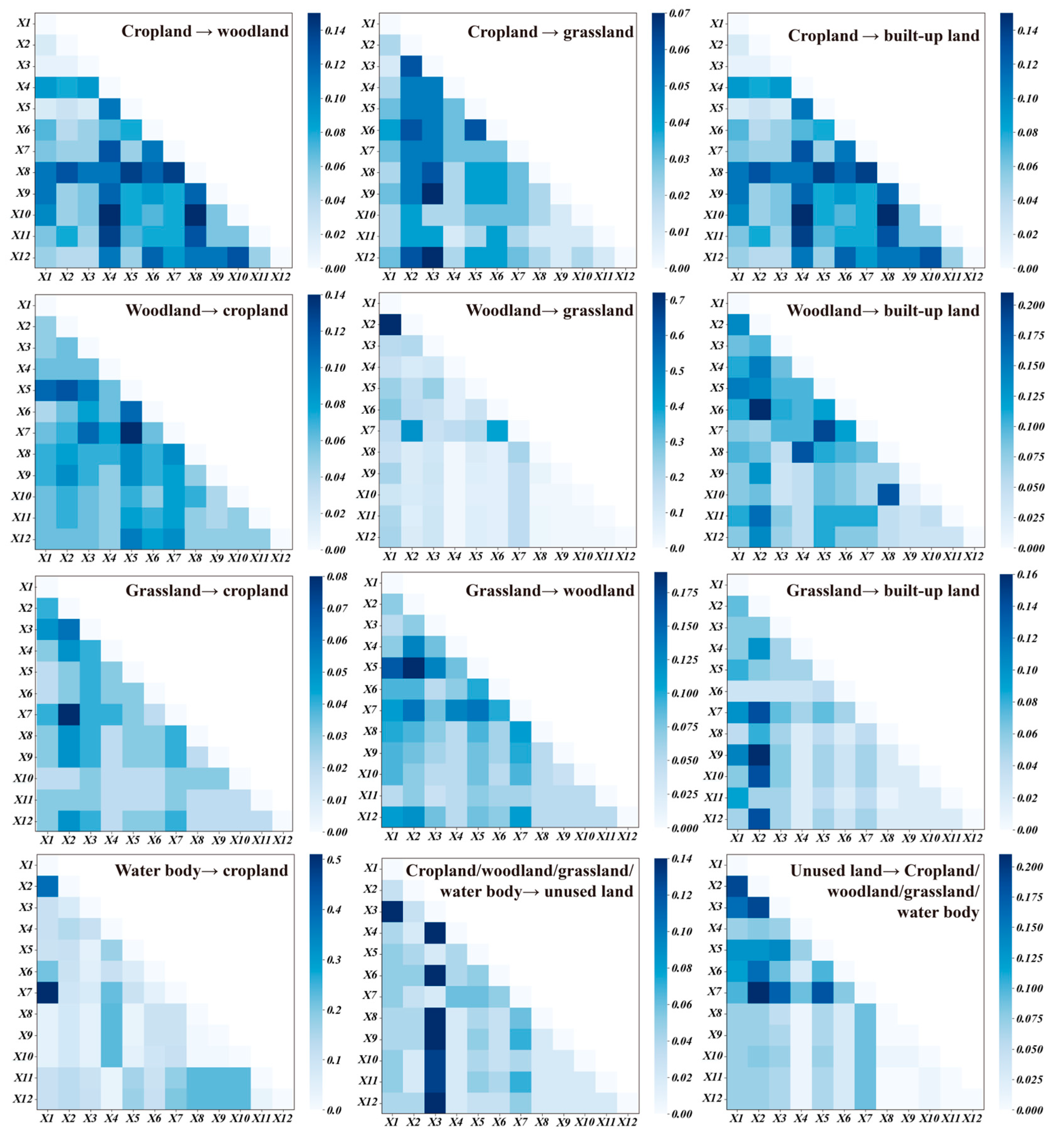
| Connotation | |
|---|---|
| 1 | Cropland → woodland |
| 2 | Cropland → grassland |
| 3 | Cropland → built-up land |
| 4 | Woodland → cropland |
| 5 | Woodland → grassland |
| 6 | Woodland → built-up land |
| 7 | Grassland → cropland |
| 8 | Grassland → woodland |
| 9 | Grassland → built-up land |
| 10 | Water body → cropland |
| 11 | Cropland/woodland/grassland/water → unused land |
| 12 | Unused land → cropland/woodland/grassland/water |
| 1990–2020 | Cropland (1) | Woodland (2) | Grassland (3) | Water Body (4) | Built-Up Land (5) | Unused Land (6) | Sum |
|---|---|---|---|---|---|---|---|
| Cropland | 20,401.7 | 587.37 | 194.17 | 9.71 | 22.64 | 77.86 | 891.75 |
| Woodland | 285.21 | 1181.81 | 20.85 | 0.88 | 1.46 | 3.86 | 312.26 |
| Grassland | 2920.88 | 588.02 | 4253.72 | 17.38 | 6.32 | 777.15 | 4309.74 |
| Water body | 131.76 | 0.3 | 20.44 | 2426.71 | 0.05 | 498.67 | 651.22 |
| Built-up land | 3.39 | 0.3 | 0.15 | 0.01 | 1557.74 | 0.2 | 4.04 |
| Unused land | 917.8 | 113.24 | 598.57 | 109.4 | 1.52 | 8929.98 | 1740.53 |
| Sum | 4259.04 | 1289.22 | 834.17 | 137.38 | 31.99 | 1357.75 | - |
| 2000–2010 | Cropland | Woodland | Grassland | Water Body | Built-Up Land | Unused Land | Sum |
| Cropland | 23,010.49 | 421.78 | 457.99 | 124.25 | 260.21 | 386.03 | 1650.25 |
| Woodland | 318.4 | 1956.86 | 104.77 | 20.94 | 15.05 | 55.02 | 514.18 |
| Grassland | 997.08 | 136.72 | 3229.79 | 13.56 | 27.37 | 683.37 | 1858.1 |
| Water body | 87.76 | 84.89 | 76.65 | 1572.54 | 15.32 | 726.95 | 991.56 |
| Built-up land | 205.38 | 11.71 | 14.31 | 1.73 | 1335.4 | 21.2 | 254.33 |
| Unused land | 593.12 | 44.49 | 620.46 | 175.34 | 61.4 | 8792.91 | 1494.81 |
| Sum | 2201.74 | 699.58 | 1274.18 | 335.82 | 379.34 | 1872.57 | - |
| 2010–2020 | Cropland | Woodland | Grassland | Water Body | Built-Up Land | Unused Land | Sum |
| Cropland | 24,513.91 | 373.51 | 78.98 | 26.12 | 133.64 | 86.07 | 698.32 |
| Woodland | 270.89 | 2337.64 | 8.98 | 17.08 | 4.25 | 17.61 | 318.8 |
| Grassland | 236.21 | 38.43 | 4120.12 | 26.44 | 13.12 | 69.64 | 383.85 |
| Water body | 22.74 | 11.39 | 8.42 | 1735.63 | 0.93 | 129.26 | 172.73 |
| Built-up land | 55.66 | 4.83 | 3.18 | 12.23 | 1632.72 | 6.12 | 82.03 |
| Unused land | 466.76 | 107.48 | 262.82 | 109.55 | 46.34 | 9672.52 | 992.95 |
| Sum | 1052.26 | 535.64 | 362.39 | 191.42 | 198.28 | 308.69 | - |
| Type | DEM (m) | Slope (°) | Aspect (°) | Annual Rainfall (mm) | Average Annual Temperature (°) | Soil Moisture (cm3/cm3) | Aridity Index |
|---|---|---|---|---|---|---|---|
| Cropland → woodland | 170–190 | 36.5–39.5 | 124–165 | 14.1–15.3 | 6.36–6.49 | 0.230–0.235 | 0.305–0.326 |
| Cropland → grassland | 303–361 | 33.9–37.8 | 170–176 | 14.1–15.8 | 6.17–6.42 | 0.215–0.232 | 0.292–0.315 |
| Cropland → built-up land | 145–156 | 16.5–32 | 151–169 | 18.1–20.9 | 6.19–6.67 | 0.256–0.286 | 0.229–0.310 |
| Woodland → cropland | 208–243 | 42.4–50.2 | 203–230 | 17.8–20.9 | 5.43–5.49 | 0.230–0.236 | 0.340–0.361 |
| Woodland → grassland | 159–165 | 41.9–45.7 | 167–180 | 16.3–17.2 | 6.15–6.26 | 0.236–0.239 | 0.355–0.367 |
| Woodland → built-up land | 159–173 | 62.2–76.5 | 202–230 | 17.5–20.9 | 5.43–5.50 | 0.222–0.230 | 0.321–0.348 |
| Grassland → cropland | 304–362 | 35.8–39.7 | 182–196 | 14.1–15.2 | 6.00–6.24 | 0.250–0.268 | 0.360–0.348 |
| Grassland → woodland | 160–167 | 35.8–39.1 | 142–155 | 16.3–17.0 | 6.61–6.67 | 0.220–0.229 | 0.292–0.298 |
| Grassland → built-up land | 146–155 | 16.9–26.7 | 164–168 | 14.1–16.2 | 5.89–6.05 | 0.219–0.241 | 0.333–0.351 |
| Water body → cropland | 159–173 | 62.2–76.5 | 202–230 | 17.8–18.1 | 5.43–5.50 | 0.222–0.230 | 0.321–0.348 |
| Cropland/woodland/grassland/water → unused land | 128–142 | 70.4–80.9 | 66.8–83.8 | 17.0–17.2 | 5.93–6.06 | 0.213–0.227 | 0.343–0.361 |
| Unused land → cropland/ woodland/grassland/water | 167–186 | 20.5–32.4 | 167–171 | 14.1–15.3 | 6.30–6.46 | 0.202–0.221 | 0.338–0.352 |
| Type | GDP (in 10,000 s RMB) | Population Size (in 10,000 s) | Agricultural Population Size (in 10,000 s) | Livestock (Head) | Urbanization Level (%) |
|---|---|---|---|---|---|
| Cropland → woodland | 777,000–1170,000 | 35.3–52.2 | 11.6–13.2 | 35,800–54,500 | 43.4–77.3 |
| Cropland → grassland | 665,000–777,000 | 29.8–35.3 | 8.02–12.4 | 25,500–43,100 | 63.7–67.2 |
| Cropland → built-up land | 1,440,000–2,240,000 | 43.8–51.2 | 28.8–43.4 | 15,100–25,500 | 33.1–45.2 |
| Woodland → cropland | 1,400,000–1,420,000 | 57.2–63.0 | 12.4–19.0 | 72,600–123,000 | 24.2–36.1 |
| Woodland → grassland | 1,400,000–1,420,000 | 57.2–63.0 | 30.4– 43.4 | 56,400–83,200 | 24.2–36.1 |
| Woodland → built-up land | 777,000–909,000 | 43.3–71.0 | 28.8–43.4 | 46,400–56,400 | 45.2–61.5 |
| Grassland → cropland | 665,000–777,000 | 27.1–35.3 | 8.02–12.4 | 25,500–43,100 | 63.7–67.2 |
| Grassland → woodland | 665,000–777,000 | 26.3–35.3 | 8.02–12.4 | 25,500–43,100 | 67.2–70.4 |
| Grassland → built-up land | 655,000–777,000 | 27.1–35.3 | 10.6–11.6 | 25,500–43,100 | 63.7–67.2 |
| Water body → cropland | 777,000–909,000 | 26.3–27.1 | 19.0–28.8 | 46,400–56,400 | 45.2–61.5 |
| Cropland/woodland/grassland/water → unused land | 901,000–1,220,000 | 35.3–37.8 | 19.0–28.8 | 15,100–25,500 | 45.2–61.5 |
| Unused land → cropland/ woodland/grassland/water | 777,000–1,310,000 | 35.3–49.0 | 11.6–13.9 | 35,800–54,500 | 43.4–77.3 |
| Time | Main Policy | Type | Trend | Direction | Rate (%) |
|---|---|---|---|---|---|
| Before 1990 | Three North Shelter Forest Program (1978–2050) [47] | - | - | - | - |
| 1990–2000 | Water Conservancy Project during 8th Five-Year Plan Period (1991–1995) [48] Returning of Farmland to River (Lake) Program (1993–2016) [49] The Outline of National Demonstration Zone Construction Planning (1996–2050) [50] Natural Forest Protection Program (1998–2020) [51] Sloping Land Conversion Program (1999–2019) [52,53] | Cropland | ↑ | Woodland | 1.58 |
| Woodland | ↑ | Cropland, Grassland | 6.54 | ||
| Grassland | ↓ | Woodland, Cropland | −4.06 | ||
| Water body | ↓ | Unused land | −1.67 | ||
| Built-up land | ↑ | Cropland, Woodland | 0.18 | ||
| Unused land | ↓ | Cropland, Woodland | −0.36 | ||
| 2000–2010 | National Wildlife Protection and Nature Reserve Construction Program (2001–2050) [54] Alkali Control Project in the West of Jilin Province (2002–) [28] Conversion of Farmland to Grassland Program (2003–2008) [55] Wetland Protection Program (2002–2030) [56] The Major Land Consolidation Project in the West of Jilin Province(2008–) [28] 100 Billion Catties Grain Production Capacity Project (2009–2020) [57] | Cropland | ↑ | Woodland | 0.22 |
| Woodland | ↑ | Cropland | 0.75 | ||
| Grassland | ↓ | Woodland, Cropland | −1.15 | ||
| Water body | ↓ | Unused land | −2.56 | ||
| Built-up land | ↑ | Unused land | 0.79 | ||
| Unused land | ↑ | Water body | 0.37 | ||
| 2010–2020 | National Desertification Prevention and Control Plan (2010–2020) [58] Nationwide Major Function Oriented Zoning (2011–2021) [59] Development Goals of “Three-life space”(2012–) [60] River-lake Connection Project (2013–) [61] Management Measures for Ecological Protection Guidelines for the Red Line of Ecological Protection (2016–) [58] Wetland Protection and Restoration System Plan (2017–) [56] | Cropland | ↑ | Woodland, Grassland | 0.14 |
| Woodland | ↑ | Cropland, Grassland | 0.82 | ||
| Grassland | ↓ | Woodland, Water body | −0.05 | ||
| Water body | ↑ | Unused land | 0.1 | ||
| Built-up land | ↑ | Cropland | 0.68 | ||
| Unused land | ↓ | Water body | −0.64 | ||
| After 2020 | The Master Plan for Major Projects of National Important Ecosystem Protection and Restoration (2021–2035) [62] Land Spatial Ecological Restoration Planning (2021–2035) [63] | - | - | - | - |
Disclaimer/Publisher’s Note: The statements, opinions and data contained in all publications are solely those of the individual author(s) and contributor(s) and not of MDPI and/or the editor(s). MDPI and/or the editor(s) disclaim responsibility for any injury to people or property resulting from any ideas, methods, instructions or products referred to in the content. |
© 2024 by the authors. Licensee MDPI, Basel, Switzerland. This article is an open access article distributed under the terms and conditions of the Creative Commons Attribution (CC BY) license (https://creativecommons.org/licenses/by/4.0/).
Share and Cite
Wen, S.; Wang, Y.; Tang, T.; Su, C.; Li, B.; Bilal, M.A.; Meng, Y. The Spatial-Temporal Patterns and Driving Mechanisms of the Ecological Barrier Transition Zone in the Western Jilin, China. Land 2024, 13, 856. https://doi.org/10.3390/land13060856
Wen S, Wang Y, Tang T, Su C, Li B, Bilal MA, Meng Y. The Spatial-Temporal Patterns and Driving Mechanisms of the Ecological Barrier Transition Zone in the Western Jilin, China. Land. 2024; 13(6):856. https://doi.org/10.3390/land13060856
Chicago/Turabian StyleWen, Shibo, Yongzhi Wang, Tianqi Tang, Congcong Su, Bowen Li, Muhammad Atif Bilal, and Yibo Meng. 2024. "The Spatial-Temporal Patterns and Driving Mechanisms of the Ecological Barrier Transition Zone in the Western Jilin, China" Land 13, no. 6: 856. https://doi.org/10.3390/land13060856
APA StyleWen, S., Wang, Y., Tang, T., Su, C., Li, B., Bilal, M. A., & Meng, Y. (2024). The Spatial-Temporal Patterns and Driving Mechanisms of the Ecological Barrier Transition Zone in the Western Jilin, China. Land, 13(6), 856. https://doi.org/10.3390/land13060856


