Article

Analysis of Dynamic Changes in Vegetation Net Primary Productivity and Its Driving Factors in the Two Regions North and South of the Hu Huanyong Line in China

1
School of Water Conservancy and Transportation, Zhengzhou University, Zhengzhou 450001, China
2
Yellow River Engineering Consulting Company Limited, Zhengzhou 450003, China
3
Key Laboratory of Water Management and Water Security for Yellow River Basin, Ministry of Water Resources (Under Construction), Zhengzhou 450003, China
4
China National Forestry-Grassland Development Research Center, Beijing 100714, China
*
Author to whom correspondence should be addressed.
Land 2024, 13(6), 722; https://doi.org/10.3390/land13060722
Submission received: 19 April 2024 / Revised: 20 May 2024 / Accepted: 20 May 2024 / Published: 22 May 2024

Abstract

:
Human activities and global environmental changes have transformed terrestrial ecosystems, notably increasing vegetation greenness in China. However, this greening is less effective across the Hu Huanyong Line (Hu Line). This study analyzes dynamic changes and driving factors of nine vegetation net primary productivities (NPPs) in regions divided by the Hu Line using remote sensing data, trend analysis, and the Geodetector model. Findings reveal that from 2001 to 2022, 38.22% of regional vegetation NPP in China increased, especially in the Loess Plateau, Sichuan Basin, and Northeast Plains, while 2.39% decreased, primarily in the southeastern region and southern Tibet. Grasslands contributed 39.71% to NPP north of the Hu Line, and cultivated vegetation contributed 50.58% south. The driving explanatory power of factors on vegetation NPP on the north side of the Hu Line is generally greater than that on the south side. Natural factors primarily drive NPP changes, with human activities having less impact. Combined factors, particularly climate and elevation, significantly enhance the driving explanatory power (q, 0–1). The joint effects of elevation and precipitation on grassland NPP dynamics (q = 0.602) are notable. GDP’s influence on broadleaf forests north of the Hu Line (q = 0.404) is significant. Grasslands respond strongly to land use changes and population density, with a combined effect of q = 0.535. Shrubs, alpine vegetation, and meadows show minimal response to individual factors (q < 0.2). These findings offer insights for devising ecological protection measures tailored to local conditions.

1. Introduction

Vegetation net primary productivity (NPP) is a crucial indicator of ecosystem function, directly related to critical scientific issues of global change such as the carbon cycle, water cycle, and food security [1]. It reflects the ecosystem’s energy storage, the productive capacity, and the combined effects of climate change and human activities on terrestrial vegetation. It offers significant reference value for ecological conservation and sustainable development [2,3]. At present, domestic and foreign scholars have achieved fruitful results in research in the fields of NPP measurement methods [4,5,6], spatiotemporal change patterns [7,8,9], and driving factors [10,11,12]. In recent years, with the rapid development of remote sensing technology, vegetation NPP estimation methods based on remote sensing observations have been effectively used for monitoring annual fluctuations and long-term trends in NPP [8,13]. Particularly, the MODIS dataset from the TERRA satellite, based on the remote sensing BIOME-BGC model [14], currently plays a significant role in global studies on vegetation growth status, spatiotemporal change patterns, and responses to climatic factor changes [15,16].
Research shows that China’s terrestrial vegetation has become significantly greener in the past 20 years [17], and regional ecosystem structures and functions have undergone changes that cannot be ignored. Many scholars have studied the spatiotemporal changes and driving factors of vegetation NPP in various regions of China and found that China’s vegetation NPP has increased significantly in recent years and is affected by climate and human activity factors to varying degrees [18,19,20]. However, it is generally difficult to cross the Hu Line when greening vegetation in China [21]. As an iconic geographical boundary, the Hu Line serves as a dividing line for population distribution density in China and as a crucial natural ecological boundary. The Hu Line divides China into two drastically different ecosystems: the northwest and the southeast [22]. In different ecosystems, the spatial and temporal changes in vegetation productivity and their complex response mechanisms to human activities, the natural environment, and other factors are still hot issues in research. Therefore, in this context, this study chose to divide China into two regions by the Hu Line and applied the geographical detector model to analyze the main driving factors and geographical differences of dynamic changes in vegetation productivity. The geographic detector model can quantitatively analyze the weights of each driving factor and detect the extent of the interactions between multiple factors and the dependent variable [23]. In recent years, many scholars have employed the geographic detector method to conduct driving factor analyses of vegetation NPP in various regions [20,24,25].
Generally speaking, the current research on changes in vegetation NPP is mainly focused on the overall regional vegetation system or specific vegetation, and there is a lack of comparative research on multiple vegetation types in different ecosystem environments; the attribution analysis of changes in vegetation NPP is also primarily limited to the influence of climate factors (mainly precipitation and temperature) [26,27,28,29] and human activities (primarily land use) [30,31,32,33]. There are still certain research gaps on the effects of soil and elevation, population density, and gross domestic product (GDP) on vegetation NPP dynamics. Through comparative analysis of multiple vegetation types in different ecosystem environments, this paper can gain a deeper understanding of the different responses of vegetation ecosystems to driving factors of the natural environment and human activities. In addition, this article expands the driving factors of the study beyond common climate variables and human activity factors, taking into account various factors, including soil, elevation, population density, and GDP. The impact of driving factors on NPP dynamics was explored from the perspectives of spatial variation and temporal variation, and the five most important driving factors affecting the dynamic changes in the NPP of various vegetation to the north and south of the Hu Line were summarized and analyzed. This provides a more comprehensive perspective for analyzing driving factors of vegetation NPP changes. The main objectives of our study are as follows: (1) to determine the dynamic changes and driving factors of the NPP of nine vegetation types in the areas north and south of the Hu Huanyong Line in China from 2001 to 2022, (2) to deeply analyze the individual and combined driving effects of various factors on the dynamic changes in the NPP for each vegetation in the two regions and to determine the five main driving factors and the driving mechanism affecting the dynamics of the NPP for each vegetation, and (3) to provide insights into China’s ecological protection projects crossing the Hu Line based on the dynamic characteristics of the NPP of Chinese vegetation and by comparing the differences in the driving factors of NPP dynamic changes across different vegetation types in various regions. In general, the research in this article aims to deeply reveal the reasons for the formation of and change in different ecosystem patterns in China. It can provide a certain reference value for realizing regional ecological protection and sustainable development based on local conditions.

2. Materials and Methods

2.1. Overview of the Study Area

China experiences distinct seasons and has a complex and diverse climate. Generally, the southern regions have a warm and humid climate with an average annual temperature ranging from approximately 15 °C to 25 °C and an annual precipitation of around 800 mm to 2000 mm. In contrast, the northern areas are cold and dry, with an average annual temperature of between −5 °C to 10 °C and an annual precipitation of about 200 mm to 800 mm (Figure 1a,b). China’s topography and landforms are complex and diverse. Overall, the terrain is higher in the west and lower in the east, with mountains, plateaus, and hills accounting for approximately 67% of the total land area. Basins and plains comprise about 33% of the total land area (Figure 1c). The region has abundant rivers and lakes (Figure 1d). Influenced by the diversity of climate and topography, China exhibits various vegetation types, including coniferous forests, broad-leaved forests, grasslands, meadows, shrublands, cultivated vegetation, high mountain vegetation, wetlands, and deserts.

2.2. Data Sources

This paper collected data from 14 representative types under six major categories: ecology, climate, soil, socio-economics, vegetation, and topography. The specific data formats, sources, and preprocessing methods are presented in Table 1. For the convenience of analysis and research, the spatial resolution of all data is unified to 1 km × 1 km, and the projection coordinate system used is the China Lambert Conformal Conic projection coordinate system.
Vegetation-type source data were reclassified into nine categories: coniferous forest (CF, covering 9.02% of the total area), broadleaf forest (BF, covering 7.25% of the total area), scrub (covering 9.96% of the total area), tussock (covering 3.40% of the total area), grassland (covering 14.52% of the total area), meadow (covering 10.67% of the total area), alpine vegetation (AV, covering 3.44% of the total area), cultivated vegetation (CV, covering 22.31% of the total area), and marsh vegetation (covering 0.64% of the total area). Unclassified desert and water bodies were collectively categorized as the no-vegetation area (accounting for 18.80% of the total area; this article does not analyze the dynamic changes and driving factors of NPP in the no-vegetation area). Among these, 99.69% of the alpine vegetation was located north of the Hu Line, and 98.20% of the tussock vegetation was located south of the Hu Line. For the convenience of analysis, alpine vegetation is classified as vegetation in the northern area of the Hu Line, and tussock is classified as vegetation in the southern area (Figure 2a).
The paper’s most crucial original dataset is the multi-year NPP data for China, sourced from NASA’s MOD17A3HGF.061 product. The data are in TIFF format as raster data. After a series of preprocessing such as cropping the source data, multiplying by scaling factors, resampling, and averaging over many years, we can obtain China’s average NPP value from 2001 to 2022 in gC/(m2·a) (Figure 2b).

2.3. Research Methods

2.3.1. Linear Trend Analysis Method

The one-variable linear regression method based on the least squares principle is a commonly used approach for studying the spatiotemporal variation of vegetation ecological indicators [35,36]. This method is employed to conduct linear trend analysis on each pixel of the processed annual NPP raster dataset, with the calculation formula presented as follows in Equation (1):
S = n × i = 1 n i × V i i = 1 n i i = 1 n V i n × i = 1 n i 2 ( i = 1 n i ) 2
In the equation, n represents the number of years of data for calculation, which in this equation is 22; i represents the year number; Vi represents the NPP value for the i-th year; and S, denoted as Slope, represents the changing slope of the vegetation NPP trend line. When S > 0 for a specific pixel, it indicates an increasing trend in vegetation NPP on that pixel; conversely, when S < 0, it indicates a decreasing trend [35]. Pixels with S equal to 0 often correspond to areas without vegetation cover.
To better express the significance of linear trend line changes on this basis, this article uses the widely used F-test to test the significance of the trend line [37,38]. The formula is as follows in Equation (2):
F = ( n 2 ) U Q U = i = 1 n ( v ^ i v ¯ ) 2 Q = i = 1 n ( v i v ^ i ) 2
In the equation, the definitions of i and n are identical to those in Equation (1); F represents the F-test statistic; U stands for the sum of squares for regression with 1 degree of freedom; Q denotes the sum of squares for residuals with n − 2 degrees of freedom, which is 20 in this equation; vi represents the value of variable v for the i-th year; v ^ i represents the linear regression value of variable v for the i-th year; and v ¯ signifies the n-year average value of variable v.
Then, using the critical value relationship between the S- and F-values at various P-levels, the changes in the linear trend lines are categorized into seven types (Table 2).

2.3.2. Geodetector Model

The Geodetector is a set of statistical methods used to detect spatial heterogeneity and uncover the underlying driving forces [23]. The Geodetector comprises primarily four types of detector models, and this article primarily utilizes the following three detector models:
(1)
Factor detector
The factor detector mainly detects the explanatory power of a certain influence factor X to the spatial differentiation of the dependent variable Y. This explanatory power is measured by the q-value, which is expressed as follows in Equation (3):
q = 1 i = 1 n N i σ i 2 N σ 2 = 1 S S W S S T
In the equation, i = 1,2,3,…, n, represents the number of partitions or categories for variable Y or factor X; Ni and N respectively denote the number of units in zone i and the entire zone; and σ i 2 and σ 2 represent the variance of Y-values in zone i and the whole zone, respectively. SSW represents the sum of within-zone variances, and SST represents the total variance of the entire zone. The range of q is [0, 1]. When q is 0, it means that factor X cannot explain the spatial heterogeneity of dependent variable Y at all, implying that factor X has no impact on Y; when q is 1, it indicates that factor X completely dominates the spatial distribution of dependent variable Y; and the higher the q value, the stronger the explanatory power of factor X for dependent variable Y.
(2)
Interaction detector
When exploring two or more influencing factors, the interaction detector can detect and calculate the degree of explanation (q-value) of the dependent variable Y when any two influencing factors Xj and Xk (jk) jointly affect it. By comparing the q-value after their interaction (q (Xj ∩ Xk)) with the q-values when they act individually (q (Xj), q (Xk)), the results of the interaction can be categorized into several types (Table 3):
In a system with multi-variable synergistic interactions, we can statistically calculate the mean value of q-value of the interaction results of a certain factor j and other factors q j ¯ to represent the comprehensive dominance degree of a certain factor in the system, as shown in Equation (4).
q j ¯ = k = 1 n q ( X j X k ) n , j = 1 , 2 , , n
(3)
Risk detector
The outcomes of the risk detector can reveal the mean of the dependent variable on each partition of the respective variable X and determine whether there is a significant difference in the mean of the dependent variable between any two partitions of variable X.

2.3.3. Determination and Partition Methods of Driving Factors

As described earlier, when applying the Geodetector model for factor detection analysis, it is essential to complete three prerequisite steps: (1) determining the independent variable X and the dependent variable Y, (2) acquiring the values of variables X and Y, and (3) performing a rational partitioning of the independent variable factor X.
For (1), this study selected a total of 12 driving factors [39,40,41] from climate, soil, socio-economic, and topographic factors as independent variables X, including mean precipitation (mean P), mean temperature (mean T), relative humidity (RH), potential evapotranspiration (PET), sunshine duration (SD), soil type (ST), soil pH (SPH), soil moisture (SM), population density (PD), gross domestic product (GDP), land use type (LUT), land use/land cover change (LUCC), and elevation (DEM). NPP serves as the dependent variable Y. The meanings and units of each variable are provided in Table 4.
For (2), due to the large study area, obtaining values for each pixel is not practical. Therefore, when conducting a Geodetector analysis, the values of variables X and Y are extracted by creating many random sampling points. In this paper, the annual mean of each factor is extracted as the spatial variation. The multi-year linear change trend S-value is used as temporal variation to analyze the driving effect of each factor’s spatial and temporal change on the NPP dynamic change of vegetation.
For (3), the partitioning of the independent variable X for each factor is shown in Table 5. Among them, soil type is digitized based on the “1:1,000,000 Soil Map of the People’s Republic of China” (1995) and reclassified into 13 categories based on data (Figure 3a), corresponding to 13 partitions; land use types are classified into 7 categories according to the first-level land classes (Figure 3b).

3. Results

3.1. Dynamic Characteristics of NPP in Vegetation on Both Sides of the Hu Line

Through spatial analysis, we got the change slope of the overall NPP of vegetation (Figure 4a), the significance of change (Figure 4b), and the annual changes in the NPP of various vegetation in China (Figure 5). It can be observed that (1) regions in China exhibiting an increasing trend in multi-year vegetation NPP are primarily located in the Loess Plateau regions of Gansu, Shanxi, and Shaanxi provinces, as well as the Sichuan Basin and the Northeast Plain. These areas are concentrated around the Hu line. Areas with decreasing NPP trends are mainly found in the southeastern parts of China, including provinces such as Jiangsu, Fujian, Jiangxi, Guangdong, Hainan, and Taiwan, as well as the southern regions of Yunnan Province and the border areas of southern Tibet. (2) In the two areas north and south of the Hu Line, the predominant trend in vegetation NPP changes for different vegetation types is either an increase or a slow increase. Among these, north of the Hu Line, the swamp vegetation exhibits the highest NPP increase trend (4.048 gC/(m2·a2)), followed by cultivated vegetation (3.490 gC/(m2·a2)), and alpine vegetation has the most miniature increase trend (0.360 gC/(m2·a2)). South of the Hu Line, grassland has the most significant NPP change trend (5.320 gC/(m2·a2)), followed by meadow (4.087 gC/(m2·a2)), and swamp vegetation shows the smallest change trend (1.787 gC/(m2·a2)).
According to the distribution of significant areas of NPP changes for the nine vegetation types (Figure 6), it is evident that on the north side of the Hu Line, the area in which the NPP of grassland shows an increasing trend (including SI, MSI, and ESI) is the largest and contributes the most to the increase in NPP, covering 52.58 × 10⁴ km2. On the south side of the Hu Line, the area where the NPP of cultivated vegetation shows an increasing trend is the largest and contributes the most to the increase in NPP, covering 103.50 × 10⁴ km2.
There is a total of 20.95 × 10⁴ km2 of vegetated areas where the NPP exhibits a decreasing trend (including SD, MSD, and ESD). Among these, cultivated vegetation, coniferous forest, broadleaf forest, and scrubland account for 29.12%, 21.00%, 14.97%, and 15.29%, respectively, making them the most significant vegetation types with decreasing NPP trends.

3.2. Identification of Driving Factors of NPP Dynamic Change in Vegetation

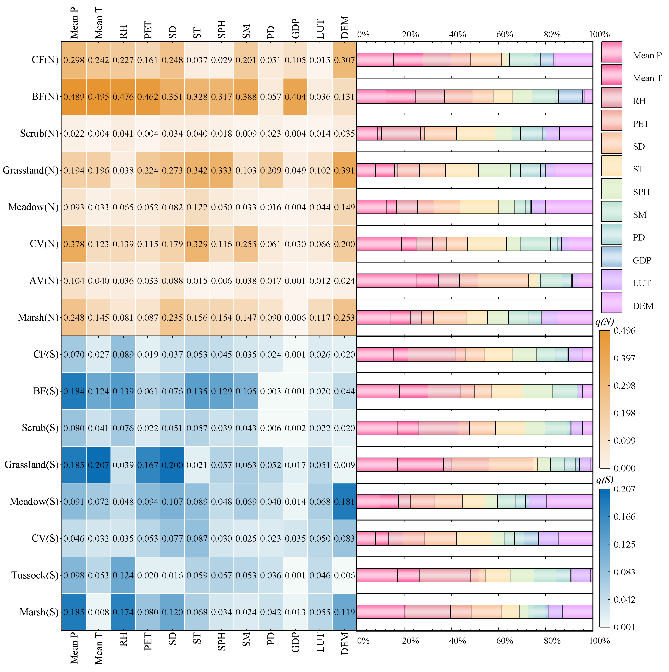
3.2.1. The Impact of Spatial Variation of Factors on Dynamic Changes in NPP

Utilizing the Geodetector model, we can obtain the factor detection results (q-values) for the influence of each factor’s spatial variation on the dynamic change trend of the NPP in vegetation types on both sides of the Hu Line (Figure 7), as well as the interaction detection results (Figure 8). Based on the interaction detection results, the comprehensive explanatory power of each factor is calculated. Combining this with the risk detection results, the driving effects of the spatial variations of five main driving factors on the dynamic changes in NPP in vegetation on both sides of the Hu Line are identified (Figure 9). The specific results of the driving effect of the spatial variations of these five main driving factors on the dynamic changes in the NPP in vegetation north and south of the Hu Line are detailed in Figure 10.
Since the article involves many vegetation types and driving factors and divides the research area into two parts for research, to discuss the results as concisely and comprehensively as possible, several abbreviations are listed here: (1) “Dynamic changes in NPP” is abbreviated as “NPPd”; (2) “spatial variation in driving factors” is abbreviated as “Xs”, where X is the abbreviation of the name of any driving factor, such as the spatial variation of DEM, abbreviated as DEMs; and (3) “temporal variation of driving factor” is abbreviated as “Xt”, where X is the abbreviation of the name of any driving factor, such as the temporal variation of mean P, abbreviated as “mean Pt”.
In general, the single-factor explanatory power of the spatial variation of each factor on the NPPd of vegetation in the northern area of Hu Line is greater than that in the southern area (q (N) = 0~0.496; q (S) = 0~0.207). The spatial variation of natural environmental factors (climate, soil, and elevation) dominates the NPPd of most vegetation, while the explanatory power of human activity factors (PD, GDP, and LUT) is generally not significant. The common explanatory power of every two factors enhances the explanatory power of every single factor, and the common driving effect of climate factors and elevation is the most obvious.
Specifically, (1) in the area north of the Hu Line, the NPPd of CF is most driven by DEMs (q = 0.307), and the joint effect of DEMs and the spatial variation of each climate factor has a significant impact on the NPPd of CF, among which DEMs∩RHs has the most significant explanatory power (q = 0.391). The NPPd of BF is largely driven by the spatial variation of climate and soil factors (q > 0.3). The explanatory power of GDPs on the NPPd of BF reaches 0.404, and BF is also the only vegetation type whose NPPd is significantly affected by GDPs. The NPPd of grassland is most driven by STs, SPHs, and DEMs (q = 0.342, 0.333, and 0.391, respectively). The joint effect of DEMs and other factors significantly impacts the NPPd of grassland, among which DEMs∩Mean Ps has the largest explanatory power, with q reaching 0.602. In addition, one point that cannot be ignored is that PDs has the greatest explanatory power for the NPPd of grassland among all vegetation (q = 0.209), and the explanatory power q of the two-factor combination of PDs and DEMs on the NPPd of grassland reaches 0.535. The NPPd of CV is mainly driven by the mean Ps and STs (q = 0.378, 0.329). The NPPd of marsh is primarily driven by the mean Ts, SDs, and DEMs (q = 0.248, 0.235, 0.253). The single-factor driving effects of the spatial variation of each factor on scrub, meadow, and AV are all small (q < 0.2), but the joint effect of DEMs and the spatial variation of each climate factor has greater explanatory power on the NPPd of meadow (q = 0.260~0.336). In the area south of the Hu Line, the single-factor explanatory power of the spatial variation of each driving factor on the NPPd of each vegetation type is small, and only mean Ts and SDs have driving explanatory power q > 0.2 for the NPPd of grassland, among which DEMs∩SDs has the largest explanatory power (q = 0.352). In addition, the joint effect of some double factors has greater explanatory power on the NPPd of meadow: DEM∩RH (q = 0.336), DEM∩SD (q = 0.309), and RH∩SD (q = 0.301).
According to the five most crucial comprehensive driving factors of each vegetation type, it can be found that there are differences in the types of driving factors and the magnitude of the driving forces for the same vegetation type in different natural geographical environments (the area south of the Hu Line and the area north of the Hu Line). In addition, it is worth emphasizing that although the overall explanatory power is not large, only the five main driver species of CV on the south side of the Hu Line have human activity category factors (LUT).

3.2.2. The Impact of Temporal Variation of Factors on Dynamic Changes in NPP

After analysis, the factor detection results for the influence of each factor’s temporal variation on the dynamic change in NPP in various vegetation types on both sides of the north and south are obtained (Figure 11), as are the interaction detection results (Figure 12). Based on the factor and interaction detection results, the influence of the temporal changes in five main driving factors on the dynamic changes in vegetation NPP on both sides of the Hu Line is analyzed (Figure 13). Further analysis based on these results yields the driving relationship results of the temporal variation of these five main driving factors on the dynamic changes in vegetation NPP on both the north and south sides of the Hu Line (Figure 14).
In general, similar to the impact of the spatial variation of factors on the NPPd of vegetation, the temporal variation of each factor has a greater single-factor driving force for each factor in the northern region of the Hu Line than in the southern region (q (N) = 0~ 0.499; q (S) = 0~0.230). However, the explanatory power of each factor has undergone some changes. The temporal variation of natural environmental factors is still the dominant reason driving most NPPd of vegetation and the driving force of human activity factors is still generally not significant. The common explanatory power of every two factors enhances the explanatory power of every single factor, and the common driving effect of RH and other climate factors is the most obvious.
Specifically, (1) in the area north of the Hu Line, PETt has the greatest driving effect on the NPPd of CF (q = 0.305), and the joint driving effect of PETt and the temporal variation of other climate factors has a significant impact on the NPPd of CF. The NPPd of BF is mainly driven by the single factors of mean Pt, RHt, PETt, and SDt (q = 0.499, 0.371, 0.451, and 0.440, respectively). The NPPd of grassland is mainly driven by mean Pt and RHt (q = 0.368, 0.212), and the explanatory power q of the joint effect of RHt∩Mean Pt reaches 0.503. In addition, for grassland, although the explanatory power of PDt and LUCC for its NPPd is not significant (q = 0.101, 0.137), this value is much greater than the explanatory power of the NPPd of PDt and LUCC on other vegetation types. In addition, the explanatory power q of the two-factor combination of PDt and mean Pt and the two-factor combination of LUCC and mean Pt reach 0.403 and 0.458, respectively, for the NPPd of grassland. The NPPd of CV is mainly driven by mean Pt, RHt, PETt, and SDt (q = 0.338, 0.290, 0.287, and 0.283, respectively), among which RHt∩Mean Pt has the greatest explanatory power (q = 0.446). The single-factor driving effects of the temporal variation of each factor on scrub, meadow, AV, and marsh are all small (q < 0.2), but among them, the combined effect of the temporal variation of mean Tt and other climate factors has a greater driving force on the NPPd of meadow (0.2 < q < 0.3), the joint effect of the temporal variation of every two climate factors has a large driving force on the NPPd of marsh (0.2 < q < 0.3), and the joint effect of LUCC and the temporal variation of each climate factor also has certain explanatory power on its NPPd. (2) In the area south of the Hu Line, the temporal variation of each driving factor has a small single-factor driving effect on the NPPd of each vegetation type. Only the driving explanatory power of RHt on grassland is q > 0.2, among which the explanatory power q of RHt∩Mean Pt reaches 0.436. In addition, the joint driving effects of some dual factors have greater explanatory power for the NPPd of marsh: SDt∩LUCC (q = 0.298), SDt∩RHt (q = 0.293), and SDt∩PETt (q = 0.291).

4. Discussion, Implications, and Limitations

4.1. Discussion

From 2001 to 2022, 38.22% of the vegetation coverage areas in China showed an increasing trend for NPP. Among them, the regions showing a relatively significant increase (MSI) and an extremely significant increase (ESI) are mainly located in the Northeast Plain, the Greater Khingan Range, the Inner Mongolia Plateau, the Loess Plateau, the Hexi Corridor, the central Qinghai Plateau, and the Sichuan Basin. Grassland and cultivated vegetation, which are widely distributed in these regions, are the two main types of vegetation showing an increasing trend in NPP. They contribute the most to the increase in NPP to the north and south of the Hu Line, respectively. This can be attributed to positive changes in natural factors such as climate in the region in recent years, as well as a series of ecological restoration and vegetation greening policies implemented by China in the area, such as “grain for green” (returning farmland to forests/grasses) [42,43,44], the “Three-North Shelterbelt Program” [45], and “natural forest resource protection” [46]. By quantifying the benefits of these policies in the form of NPP, we can intuitively see China’s “Green Breakthrough Hu Line” efforts in recent years. The regions showing a decreasing trend in NPP mainly include parts of the southeastern areas, including Jiangsu Province, Fujian Province, Jiangxi Province, Guangdong Province, Hainan Province, and Taiwan Province, as well as the border regions in the southern part of Yunnan Province and the southern part of Tibet, primarily due to the intensification of industrialization and urbanization processes in southwestern and coastal regions in recent years [47].
For the entire study area, the spatiotemporal changes in various factors have a generally greater driving effect on the dynamic changes in vegetation NPP in the areas north of the Hu Line than in the areas south. This shows that the dynamics of vegetation NPP in the area north of the Hu Line are generally more sensitive to the driving response of various factors. In contrast, the dynamics of vegetation NPP in the area south of the Hu Line are more stable in response to the driving factors of various factors. This is because the climate pattern in the area north of the Hu Line in China is generally relatively singular, the ecosystem is very fragile, and the vegetation structure and function will respond more obviously to changes in factors [22].
According to the detection results of driving factors, it can be found that climate factors, especially spatial changes in precipitation or temperature, play an important role in the dynamic changes of NPP of most vegetation (CF (N) BF, grassland, CV (N), and marsh), which is consistent with the conclusions of Li et al., Chen et al., and Hou et al. [48,49,50]. In addition, elevation and soil factors also greatly influence the dynamic changes in NPP of some vegetation. For example, the spatial variation of DEM has the greatest driving effect on CF (N), grassland (N), and marsh (N) (q = 0.307, 0.391, and 0.253, respectively). The influence of ST on BF (N), grassland (N), and CV (N) is significant (q = 0.328, 0.342, and 0.329, respectively). Moreover, the joint effect of DEM and the spatial variation of various climate factors has an obvious driving effect on the dynamic changes in NPP of various vegetation. This is mainly because elevation changes directly affect the light and heat environment, moisture, and soil physical and chemical properties for plant growth, and then affect its structure and function [51]. This shows that some scholars only consider climate factors to be natural driving factors of NPP changes, which lacks a certain degree of comprehensiveness [27,49].
From the perspective of human activity factors, the dynamic change in the broad-leaved forest on the north side of the Hu Line significantly responds to the spatial variation of GDP (q = 0.404). Combined with the distribution region of broad-leaved forest, it can be seen that the broad-leaved forest on the north side of the Hu Line is concentrated in southern Tibet, China. Southern Tibet is densely populated, and in recent years, the economy based on tourism has developed rapidly, which greatly impacts the ecological environment [52]. The dynamic changes in NPP in grassland on the north side of the Hu Line are greatly affected by human activity factors. In particular, the joint effect of the spatial variation of PD and DEM, the joint effect of the temporal variation of mean T, and LUCC significantly drive the dynamic changes in NPP (q = 0.535 and 0.458, respectively). This is because the grassland vegetation on the northwest side of the Hu Line is mainly desert grassland and pasture grassland. The desert grassland habitat is fragile and susceptible to external factors; the pasture grassland is mainly affected by human intervention. The dynamic changes in NPP of marsh vegetation on the north and south sides of the Hu Line are significantly affected by SD and LUCC. This is because marshes, as fragile ecosystems, are greatly affected by light and heat conditions and are more susceptible to the impact of human activities [53].
The explanatory power of the interaction between human activity and natural activity factors is greater than the explanatory power of the two alone, indicating that natural factors and human factors promote each other and cooperatively control the dynamic changes in NPP of each vegetation type.

4.2. Implications and Suggestions

This paper conducted an in-depth analysis of the NPP dynamics and driving factors of various vegetation types on both sides of the Hu Huanyong Line and found large differences in the size, changing trend, main driving factors, and driving effects of each vegetation NPP in different areas. Therefore, regional differences should be fully considered in formulating relevant policies such as ecological restoration and protection, and a more directional coordinated regional development of the country’s ecological environment should be achieved. Specifically, grassland vegetation contributes greatly to the increase in NPP for the ecologically fragile areas north of the Hu Line. Still, it is greatly affected by climate, elevation, and human activity factors. Therefore, ecological protection projects for grasslands should be implemented in a planned manner. As for broad-leaved forests and marsh vegetation, attention should also be paid to their protection in economic and social development. In addition, this paper found that on the north side of Hu Line, in addition to meadows and alpine vegetation mainly distributed in plateau areas, which are less affected by multiple driving factors, scrub vegetation also has great stability in the influence of various factors. Therefore, it is recommended that when carrying out preliminary greening work in the northwest, shrubbery vegetation should be planted first and then other vegetation types should be planted after the ecological environment improves.
Affected by the natural endowment of altitude, the “ecological barrier” of the Hu Huanyong Line cannot be eliminated, but this does not mean that it cannot be crossed from certain areas. Combined with the spatial and temporal changes in China’s NPP, it can be found that the northwest region is not all deserts that are difficult to develop. There are also some green areas with a good ecological environment in the form of points or lines, such as the Lanzhou–Xining area, the Ningxia Yellow River area, the Gansu Hexi Corridor area, the Urumqi area on the northern slope of the Tianshan Mountains, and the southeastern Tibet area. These areas are relatively rich in natural resources and have a good ecological environment. Priority can be given to expanding the ecological greening of this area, thereby promoting economic development and making it grow into an urban agglomeration, improving population agglomeration capacity, connecting points to lines, forming lines into planes, and ultimately achieving further crossing of the Hu Huanyong Line.

4.3. Limitations and Prospects

This paper uses the Geodetector model to analyze the dynamic driving factors of vegetation NPP. This model does not require any preset model form, can intuitively measure each factor’s degree and mechanism of influence on the research object, and can determine every two joint driving effects of factors. However, the accuracy of the results has extensive requirements for the quantity and quality of data and is greatly affected by variable selection and variable partitioning methods [54]. In subsequent research, we can consider combining geographical detectors with other driving factor identification methods such as decision trees [55,56], random forests [57,58], and geographically weighted regression (GWR) [59,60] for mutual verification to ensure the reliability of the results further. In addition, compared with the three human activity factors selected in this article (GDP, population density, and land use), to further highlight the impact of human activity factors on vegetation NPP dynamics, it may be considered to add some factors that better reflect the intensity of human activities for analysis, such as human activity footprint, resource consumption intensity, and environmental pollution level [61,62].

5. Conclusions

With the change in global climate and the intensification of human activities, the structure and function of terrestrial ecosystems have undergone tremendous changes in recent years. Most studies have shown that China’s land cover has become significantly greener in recent years, but this greening trend is not effective when crossing the Hu Huanyong Line. Therefore, this study conducted a comprehensive and targeted analysis of the dynamic changes and driving factors of the net primary productivity of nine vegetation types in two areas separated by the Hu Line. The research conclusions are as follows:
(1)
Over the past 20 years, 38.22% of the regional vegetation NPP in China increased, mainly in the Loess Plateau, Sichuan Basin, and Northeast Plains, while 2.39% decreased, primarily in southeastern China and southern Tibet. The NPP for all vegetation types increased. Grasslands contributed the most to NPP growth north of the Hu Line (39.71%), while cultivated vegetation was the primary contributor south of the Hu Line (50.58%).
(2)
The spatiotemporal changes in various factors have a generally more significant driving effect on the dynamic changes in vegetation NPP in the areas north of the Hu Line than in the regions south. The vegetation ecosystem on the north side of the Hu Line is more fragile than that on the south side.
(3)
The grassland and broad-leaved forest on the north side of the Hu Line, as well as the marshes on the north and south sides, are greatly affected by human activities. The dynamic changes in NPP of other vegetation types are mainly affected by natural activities, with the most significant effect being the combined effect of elevation and climate factors. Shrubs, alpine vegetation, and meadows show minimal response to the driving impact of individual factors (q < 0.2).

Author Contributions

Methodology, D.Y., Z.Y., Z.W. and J.Y.; Software, W.L.; Validation, W.L. and Z.W.; Formal analysis, D.Y.; Resources, Z.Y., H.W., J.Y., S.L. and T.W.; Data curation, Z.Y.; Writing—original draft, W.L.; Writing—review & editing, Z.Y.; Visualization, W.L.; Supervision, D.Y., Z.Y. and Z.W.; Funding acquisition, H.W. All authors have read and agreed to the published version of the manuscript.

Funding

This research was funded by the National Science and Technology Major Project of the Ministry of Science and Technology of China (grant Nos. 2023YFC3208605 and 2021YFC3000204), the National Natural Science Foundation of China (grant Nos. 52109038, 52209038, 52279028), and the Research Fund of the Key Laboratory of Water Management and Water Security for the Yellow River Basin, Ministry of Water Resources (grant No. 2023-SYSJJ-10).

Data Availability Statement

The original contributions presented in the study are included in the article, further inquiries can be directed to the corresponding author.

Acknowledgments

We sincerely thank all members of Zhengzhou University who contributed to the collection and processing of the data for this article.

Conflicts of Interest

Author Dengming Yan was employed by the Yellow River Engineering Consulting Company Limited. The remaining authors declare that the research was conducted in the absence of any commercial or financial relationships that could be construed as a potential conflict of interest.

References

  1. Wang, Z.; Guo, Z.; Song, K.; Liu, D.; Zhang, B.; Zhang, S.; Li, F.; Jin, C.; Yang, T.; Huang, N. Effects of Land Use/Cover Change on Net Primary Productivity of Sanjiang Plain, during 2000–2005. J. Nat. Resour. 2009, 24, 136–146. [Google Scholar]
  2. Ahlstrom, A.; Xia, J.; Arneth, A.; Luo, Y.; Smith, B. Importance of vegetation dynamics for future terrestrial carbon cycling. Environ. Res. Lett. 2015, 10, 054019. [Google Scholar] [CrossRef]
  3. Zhou, Y.; Yue, D.; Li, C.; Mu, X.; Guo, J. Identifying the spatial drivers of net primary productivity: A case study in the Bailong River Basin, China. Glob. Ecol. Conserv. 2021, 28, e01685. [Google Scholar] [CrossRef]
  4. Clark, D.A.; Brown, S.; Kicklighter, D.W.; Chambers, J.Q.; Thomlinson, J.R.; Ni, J. Measuring net primary production in forests: Concepts and field methods. Ecol. Appl. 2001, 11, 356–370. [Google Scholar] [CrossRef]
  5. Schuur, E.A.G.; Bockheim, J.; Canadell, J.G.; Euskirchen, E.; Field, C.B.; Goryachkin, S.V.; Hagemann, S.; Kuhry, P.; Lafleur, P.M.; Lee, H.; et al. Vulnerability of permafrost carbon to climate change: Implications for the global carbon cycle. Bioscience 2008, 58, 701–714. [Google Scholar] [CrossRef]
  6. Wang, Y.; Xia, W.; Liang, T. Research progress on spatial-temporal dynamic simulation model of net primary productivity of terrestrial ecosystems. Pratacultural Sci. 2010, 27, 77–88. [Google Scholar]
  7. Nemani, R.R.; Keeling, C.D.; Hashimoto, H.; Jolly, W.M.; Piper, S.C.; Tucker, C.J.; Myneni, R.B.; Running, S.W. Climate-driven increases in global terrestrial net primary production from 1982 to 1999. Science 2003, 300, 1560–1563. [Google Scholar] [CrossRef]
  8. Pan, J.; Li, Z. Temporal-spatial change of vegetation net primary productivity in the arid region of Northwest China during 2001 and 2012. Chin. J. Ecol. 2015, 34, 3333–3340. [Google Scholar]
  9. Kamali, A.; Khosravi, M.; Hamidianpour, M. Spatial-temporal analysis of net primary production (NPP) and its relationship with climatic factors in Iran. Environ. Monit. Assess. 2020, 192, 718. [Google Scholar] [CrossRef]
  10. Nautiyal, M.C.; Nautiyal, B.P.; Prakash, V. Effect of Grazing and Climatic Changes on Alpine Vegetation of Tungnath, Garhwal Himalaya, India. Environmentalist 2004, 24, 125–134. [Google Scholar] [CrossRef]
  11. Del Grosso, S. Global potential net primary production predicted from vegetation class, precipitation, and temperature. Ecology 2008, 89, 2971. [Google Scholar] [CrossRef] [PubMed]
  12. Ge, W.; Deng, L.; Wang, F.; Han, J. Quantifying the contributions of human activities and climate change to vegetation net primary productivity dynamics in China from 2001 to 2016. Sci. Total Environ. 2021, 773, 145648. [Google Scholar] [CrossRef]
  13. Cui, L.; Shi, J.; Xiao, F. Impacts of climatic factors and El Nino/La Nina events on the changes of terrestrial ecosystem NPP in China. Acta Geogr. Sin. 2018, 73, 54–66. [Google Scholar]
  14. Potter, C.S.; Randerson, J.T.; Field, C.B.; Matson, P.A.; Vitousek, P.M.; Mooney, H.A.; Klooster, S.A. Terrestrial ecosystem production-a process model-based on global satellite and surface data. Glob. Biogeochem. Cycles 1993, 7, 811–841. [Google Scholar] [CrossRef]
  15. Liu, M.; Jiao, J.; Pan, J.; Song, J.; Che, Y.; Li, L. Spatial and temporal patterns of planting NPP and its driving factors in Qinghai Province. Acta Ecol. Sin. 2020, 40, 5306–5317. [Google Scholar]
  16. Liu, L.; Sun, H.; Li, C. Estimation of grassland NPP in the Qinghai-Tibet Plateau based on the improved Biome-BGC model considering soil freeze-thaw water cycle. Geogr. Res. 2021, 40, 1253–1264. [Google Scholar] [CrossRef]
  17. Chen, C.; Park, T.; Wang, X.; Piao, S.; Xu, B.; Chaturvedi, R.K.; Fuchs, R.; Brovkin, V.; Ciais, P.; Fensholt, R.; et al. China and India lead in greening of the world through land-use management. Nat. Sustain. 2019, 2, 122–129. [Google Scholar] [CrossRef]
  18. Ma, B.; Jing, J.; Liu, B.; Xu, Y.; Dou, S.; He, H. Quantitative assessment of the relative contributions of climate change and human activities to NPP changes in the Southwest Karst area of China. Environ. Sci. Pollut. Res. 2022, 29, 80597–80611. [Google Scholar] [CrossRef]
  19. Shi, Z.; Wang, Y.; Zhao, Q.; Zhang, L.; Zhu, C. The Spatiotemporal Changes of NPP and Its Driving Mechanisms in China from 2001 to 2020. Ecol. Environ. Sci. 2022, 31, 2111–2123. [Google Scholar]
  20. Xu, Y.; Huang, W.; Zheng, Z.; Dai, Q.; Li, X. Detecting Influencing Factor of Vegetation NPP in Southwest China Based on Spatial Scale Effect. Environ. Sci. 2023, 44, 900–911. [Google Scholar] [CrossRef]
  21. Liu, H. It is difficult for China’s greening through large-scale afforestation to cross the Hu Line. Sci. China-Earth Sci. 2019, 62, 1662–1664. [Google Scholar] [CrossRef]
  22. Wang, K.; Deng, Y. Can new urbanization break through the Hu Huanyong Line? Further discussion on the geographical connotations of the Hu Huanyong Line. Geogr. Res. 2016, 35, 825–835. [Google Scholar]
  23. Wang, J.; Xu, C. Geodetector: Principle and prospective. Acta Geogr. Sin. 2017, 72, 116–134. [Google Scholar]
  24. Pan, H.; Huang, P.; Xu, J. The spatial and temporal pattern evolution of vegetation NPP and its driving forces in middle-lower areas of the Min river based on geographical detector analyses. Acta Ecol. Sin. 2019, 39, 7621–7631. [Google Scholar]
  25. Wang, Y.; Shen, X.; Lv, X. Change Characteristics of Landscape Pattern and Climate in Marsh Areas of Northeast China during 1980-2015. Earth Environ. 2020, 48, 348–357. [Google Scholar]
  26. Eisfelder, C.; Klein, I.; Niklaus, M.; Kuenzer, C. Net primary productivity in Kazakhstan, its spatio-temporal patterns and relation to meteorological variables. J. Arid Environ. 2014, 103, 17–30. [Google Scholar] [CrossRef]
  27. Tong, L.; Liu, Y.; Wang, Q.; Yang, Y.; Li, J. Spatial and Temporal Dynamics of Net Primary Productivity and Its Driving Factors in Northwest China. Res. Soil Water Conserv. 2019, 26, 367–374. [Google Scholar]
  28. Zheng, Z.; Zhu, W.; Zhang, Y. Seasonally and spatially varied controls of climatic factors on net primary productivity in alpine grasslands on the Tibetan Plateau. Glob. Ecol. Conserv. 2020, 21, e00814. [Google Scholar] [CrossRef]
  29. Liu, Z.; Yang, J.; Ma, L.; Ke, Z.; Hu, Y.; Yan, X. Spatial-temporal trend of grassland net primary production and their driving factors in the Loess Plateau, China. Chin. J. Appl. Ecol. 2021, 32, 113–122. [Google Scholar] [CrossRef]
  30. Yan, H.; Zhan, J.; Wu, F.; Yang, H. Effects of Climate Change and LUCC on Terrestrial Biomass in the Lower Heihe River Basin during 2001–2010. Energies 2016, 9, 260. [Google Scholar] [CrossRef]
  31. Yan, Y.; Liu, X.; Wen, Y.; Ou, J. Quantitative analysis of the contributions of climatic and human factors to grassland productivity in northern China. Ecol. Indic. 2019, 103, 542–553. [Google Scholar] [CrossRef]
  32. Yang, H.; Hu, D.; Xu, H.; Zhong, X. Assessing the spatiotemporal variation of NPP and its response to driving factors in Anhui province, China. Environ. Sci. Pollut. Res. 2020, 27, 14915–14932. [Google Scholar] [CrossRef] [PubMed]
  33. Yang, A.; Zhang, X.; Li, Z.; Li, Y.; Nan, F. Quantitative analysis of the impacts of climate change and human activities on vegetation NPP in the Qilian Mountain National Park. Acta Ecol. Sin. 2023, 43, 1784–1792. [Google Scholar]
  34. Chen, J.; Gao, M.; Cheng, S.; Hou, W.; Song, M.; Liu, X.; Liu, Y. Global 1 km × 1 km gridded, revised, real gross domestic product and electricity consumption during 1992–2019 based on calibrated nighttime light data. Sci. Data 2022, 9, 202. [Google Scholar] [CrossRef] [PubMed]
  35. Liu, Y.; Zhang, J.; Zhang, C.; Xiao, B.; Liu, L.; Cao, Y. Spatial and temporal variations of vegetation net primary productivity and its responses to climate change in Shandong Province from 2000 to 2015. Chin. J. Ecol. 2019, 38, 1464–1471. [Google Scholar]
  36. Fox, J. Applied Regression Analysis and Generalized Linear Models, 3rd ed.; Sage Publications: Thousand Oaks, CA, USA, 2015. [Google Scholar]
  37. Mu, S.; Li, J.; Zhou, W.; Yang, H.; Zhang, C. Spatial-temporal distribution of net primary productivity and its relationship with climate factors in Inner Mongolia from 2001 to 2010. Acta Ecol. Sin. 2013, 33, 3752–3764. [Google Scholar]
  38. Fisher, R.A. Statistical Methods for Research Workers, 1st ed.; Oliver and Boyd: Edinburgh, UK, 1925. [Google Scholar]
  39. Li, J.; Yang, Y.; Zhang, H.; Huang, L.; Gao, Y. Spatio-temporal variations of net primary productivity and its natural and human factors analysis in Qinling-Daba Mountains in the past 15 years. Acta Ecol. Sin. 2019, 39, 8504–8515. [Google Scholar]
  40. Wang, W.; Alim, S.; Jilili, A. Geo—detector based spatio—Temporal variation characteristics and driving factors analysis of NDVI in Central Asia. Remote Sens. Land Resour. 2019, 31, 32–40. [Google Scholar]
  41. Sun, Z.; Xie, S. Spatiotemporal variation in net primary productivity and factor detection in Yunnan Province based on geodetector. Chin. J. Ecol. 2021, 40, 3836–3848. [Google Scholar]
  42. Li, S.; Yan, J.; Liu, X.; Wan, J. Response of vegetation restoration to climate change and human activities in Shaanxi-Gansu-Ningxia Region. J. Geogr. Sci. 2013, 23, 98–112. [Google Scholar] [CrossRef]
  43. Xie, B.; Qin, Z.; Wang, Y.; Chang, Q. Spatial and temporal variation in terrestrial net primary productivity on Chinese Loess Plateau and its influential factors. Trans. Chin. Soc. Agric. Eng. 2014, 30, 244–253. [Google Scholar]
  44. Yi, L.; Ren, Z.; Zhang, C.; Liu, W. Vegetation Cover, Climate and Human Activities on the Loess Plateau. Resour. Sci. 2014, 36, 166–174. [Google Scholar]
  45. Wang, Q.; Zhang, B.; Dai, S.; Zhang, F.; Zhao, Y.; Yin, H.; He, X. Analysis of the vegetation cover chang and its relationship with factors in the Three-North Shelter Forest Program. China Environ. Sci. 2012, 32, 1302–1308. [Google Scholar]
  46. Li, D.; Wang, Z. Quantitative Analysis of the Impact of Climate Change and Human Activities on Vegetation NPP in Shaanxi Province. Ecol. Environ. Sci. 2022, 31, 1071–1079. [Google Scholar]
  47. Xue, P.; Liu, H.; Zhang, M.; Gong, H.; Cao, L. Nonlinear Characteristics of NPP Based on Ensemble Empirical Mode Decomposition from 1982 to 2015-A Case Study of Six Coastal Provinces in Southeast China. Remote Sens. 2022, 14, 15. [Google Scholar] [CrossRef]
  48. Hou, Y.; Liu, Q.; Yan, H.; Tian, G. Variation trends of China terrestrial vegetation net primary productivity and its responses to climate factors in 1982–2000. J. Appl. Ecol. 2007, 18, 1546–1553. [Google Scholar]
  49. Chen, F.; Shen, Y.; Li, Q.; Guo, Y.; Xu, L. Spatio-temporal Variation Analysis of Ecological Systems NPP in China in Past 30 years. Sci. Geogr. Sin. 2011, 31, 1409–1414. [Google Scholar]
  50. Li, Z.; Chen, J.; Chen, Z.; Sha, Z.; Yin, J.; Chen, Z. Quantifying the contributions of climate factors and human activities to variations of net primary productivity in China from 2000 to 2020. Front. Earth Sci. 2023, 11, 1084399. [Google Scholar] [CrossRef]
  51. Xu, Y.; Huang, J.; Lu, X.; Ding, Y.; Zang, R. Priorities and conservation gaps across three biodiversity dimensions of rare and endangered plant species in China. Biol. Conserv. 2019, 229, 30–37. [Google Scholar] [CrossRef]
  52. Li, Y.; Li, F.; Chen, C. The spatial evolution characteristics and driving forces of village and town settlements in the Qinghai-Tibet Plateau. Res. Agric. Mod. 2021, 42, 1114–1125. [Google Scholar]
  53. Feng, X.K.; Zhao, Z.Z.; Ma, T.; Hu, B.X. A study of the effects of climate change and human activities on NPP of marsh wetland vegetation in the Yellow River source region between 2000 and 2020. Front. Ecol. Evol. 2023, 11, 1123645. [Google Scholar] [CrossRef]
  54. Liang, J.; Chen, W.; Li, J.; Dong, M.; Zhou, T.; Pan, S. Spatiotemporal patterns of landscape fragmentation and causes in the Yellow River Basin. Acta Ecol. Sin. 2022, 42, 1993–2009. [Google Scholar]
  55. Guo, Q.; Fu, B.; Shi, P.; Cudahy, T.; Zhang, J.; Xu, H. Satellite Monitoring the Spatial-Temporal Dynamics of Desertification in Response to Climate Change and Human Activities across the Ordos Plateau, China. Remote Sens. 2017, 9, 525. [Google Scholar] [CrossRef]
  56. Wang, Y.; Tang, W.; Li, S.; Zhao, H.; Xie, J.; Ma, C.; Yan, C. Change in grassland productivity in Qinghai Province and its driving factors. Acta Prataculturae Sin. 2022, 31, 1–13. [Google Scholar]
  57. Li, C.; Sun, H.; Wang, Y.; Cao, H.; Yin, H.; Zhou, M.; Zhu, T. Estimation of grassland net primary productivity in permafrost of Qinghai-Tibet Plateau based on machine learning. Chin. J. Ecol. 2020, 39, 1734–1744. [Google Scholar]
  58. Huang, C.; Yang, Q.; Huang, W. Analysis of the Spatial and Temporal Changes of NDVI and Its Driving Factors in the Wei and Jing River Basins. Int. J. Environ. Res. Public Health 2021, 18, 11863. [Google Scholar] [CrossRef] [PubMed]
  59. Zhao, Y.; Sun, R.; Ni, Z. Identification of Natural and Anthropogenic Drivers of Vegetation Change in the Beijing-Tianjin-Hebei Megacity Region. Remote Sens. 2019, 11, 1224. [Google Scholar] [CrossRef]
  60. Liu, Y.; Liu, S.; Sun, Y.; Li, M.; An, Y.; Shi, F. Spatial differentiation of the NPP and NDVI and its influencing factors vary with grassland type on the Qinghai-Tibet Plateau. Environ. Monit. Assess. 2021, 193, 48. [Google Scholar] [CrossRef]
  61. Wei, J.; Xiao, D.; Xie, F. Evaluation and Regulation Principles for the Effects of Human Activities on Ecology and Environment. Prog. Geogr. 2006, 25, 36–45. [Google Scholar]
  62. Cheng, Y.; Liu, K.; Xu, C.; Ren, J. A Comparative Study of Man-Land System in Shandong Peninsula Blue Economic Zone about Sustainable Evaluation and Spatial Types. Econ. Geogr. 2015, 35, 118–125. [Google Scholar] [CrossRef]
Figure 1. Overview of the study area: (a) average annual precipitation in the study area; (b) average annual temperature in the study area; (c) elevation of the study area; (d) water system in the study area).
Land 13 00722 g001
Figure 2. Vegetation types (a) and the annual average spatial distribution of NPP in the study area (b). (In Figure (a): CF is coniferous, BF is broadleaf forest, AV is alpine vegetation, and CV is cultivated vegetation).
Land 13 00722 g002
Figure 3. Study area soil type (a) and land use type (b) in 2020.
Land 13 00722 g003
Figure 4. Dynamic change pattern of the NPP in the study area: (a) The linear trend of the NPP change in the study area from 2001 to 2022; (b) NPP change significance in the study area. In the figure, SI, MSI, and ESI indicate significant increases, more significant increases, and extremely significant increases, respectively. SD, MSD, and ESD respectively indicate significant decreases, more significant decreases, and extremely significant decreases.
Land 13 00722 g004
Figure 5. The variation trend of NPP of vegetation from year to year. (In the figure: CF is coniferous, BF is broadleaf forest, AV is alpine vegetation, and CV is cultivated vegetation. N refers to the north side of the Hu Huanyong Line. S refers to the south side of the Hu Huanyong Line).
Land 13 00722 g005
Figure 6. Cumulative area statistics chart of significant change types in vegetation NPP in the overall study area (a) and north (b) and south (c) of the Hu Line. In the Figure, CF is coniferous, BF is broadleaf forest, AV is alpine vegetation, and CV is cultivated vegetation. SI, MSI, and ESI indicate significant increases, more significant increases, and extremely significant increases, respectively. SD, MSD, and ESD respectively indicate significant decreases, more significant decreases, and extremely significant decreases.
Land 13 00722 g006
Figure 7. Factor detector results of the impact of the spatial variation of driving factors on the dynamic changes in vegetation NPP on both sides of the Hu Line.
Land 13 00722 g007
Figure 8. Interactive detector results of the impact of the spatial variation of driving factors on the dynamic changes in vegetation NPP on both sides of the Hu Line.
Land 13 00722 g008
Figure 9. The five main driving factors (spatial variation) and the driving mechanism affecting the dynamics of NPP for each vegetation type.
Land 13 00722 g009
Figure 10. Driving mechanisms of spatial variations of five primary driving factors on the dynamic changes in vegetation NPP on both the north and south sides of the Hu Line in the study area (in this figure: X represents the annual average of each factor, and Y represents the linear trend of vegetation NPP).
Land 13 00722 g010
Figure 11. Factor detector results of the impact of the temporal variation of driving factors on the dynamic changes of vegetation NPP on both sides of the Hu Line.
Land 13 00722 g011
Figure 12. Interactive detector results of the impact of the temporal variation of driving factors on the dynamic changes of vegetation NPP on both sides of the Hu Line.
Land 13 00722 g012
Figure 13. The five main driving factors (temporal variation) and the driving mechanism affecting the dynamics of NPP for each vegetation type.
Land 13 00722 g013
Figure 14. Driving mechanisms of temporal variation in five primary driving factors on the dynamic changes in vegetation NPP on both the north and south sides of the Hu Line in the study area (in this figure, X represents the linear trend of each factor, and Y represents the linear trend of vegetation NPP).
Land 13 00722 g014
Table 1. Data sources and processing methods.
Data SetTime ResolutionData Source
TypeName
EcologyNPP Data Set (2001–2022)1 yearNASA’s MOD17A3HGF.061 product
ClimateAverage Precipitation Data Set (2001–2021)1 monthNational Earth System Science Data Center (www.geodata.cn) (accessed on 20 October 2023)
Average Temperature Data Set (2001–2021)
Potential EvAPOtranspiration Data Set (2001–2021)
Relative Humidity Data Set (2001–2020)
Sunshine Duration Data Set (2001–2020)
SoilSoil Type Data Set (1995)1 yearHarmonized World Soil Database (HWSD)
Soil pH Data Set (2010)
Soil Moisture (30 cm) Data Set (2001–2020)1 dayNational Tibetan Plateau Scientific Data Center
Socio-economicLand Use Data Sets (2000, 2005, 2010, 2015, 2020)1 year
GDP Raster Data Sets (2000, 2005, 2010, 2015, 2020)Chen J. et al., 2022 [34]
Population Density Data Set (2001–2021)LandScan population dataset developed by the U.S. Department of Energy’s Oak Ridge National Laboratory
Vegetation typeSpatial Distribution Data Set of Vegetation Types in China (2000)1 yearResources and Environmental Science and Data Center, Chinese Academy of Sciences
LandformChina DEM Data Set (2000)1 year
Table 2. Trend line change degree division.
S-ValueSignificance Test Level p-ValueF-ValueSignificance Change Type
( 0 , + ) ( , 0.05 ) ( 4.351 , 8.096 ) Significant increase (SI)
( 0 , + ) ( , 0.01 ) ( 8.096 , 14.819 ) More significant increase (MSI)
( 0 , + ) ( , 0.001 ) ( 14.819 , + ) Extremely significant increase (ESI)
( , + ) ( 0.05 , + )   or   ( , 4.351 ) No significant change
( , 0 ) ( , 0.05 ) ( 4.351 , 8.096 ) Significant decrease (SD)
( , 0 ) ( , 0.01 ) ( 8.096 , 14.819 ) More significant decrease (MSD)
( , 0 ) ( , 0.001 ) ( 14.819 , + ) Extremely significant decrease (ESD)
Table 3. Interaction type criteria.
q-Value RelationInteraction Type
q (XjXk) < Min (q (Xj), q (Xk))Nonlinearity attenuation
Min (q (Xj), q (Xk)) < q (XjXk) < Max (q (Xj), q (Xk))The single-factor nonlinearity decreases
q (XjXk) > Max (q (Xj), q (Xk))Two-factor enhancement
q (XjXk) = q (Xj) + q (Xk)Independent
q (XjXk) > q (Xj) + q (Xk)Nonlinear enhancement
Table 4. Factor description.
Variable TypeVariable NameVariable DescriptionVariable Unit
ClimateMean PAverage annual precipitation from 2001 to 2021mm
Mean TAverage annual temperature from 2001 to 2021
PETAverage annual potential evapotranspiration 2001–2021mm
RHAverage annual relative humidity from 2001 to 2020%
SDAnnual average sunshine duration 2001–2020hr
SoilSMAnnual average soil moisture from 2001 to 2020 (30 cm)m3/m3
SPHSoil pH value in 2010/
STSoil types in 1995/
Socio-economicPDAverage annual population density 2001–2021People/km2
GDPGDP in 2000, 2010, 2015, and 2020trillion yuan
LUTLand use types in 2000, 2010, 2015, and 2020/
LUCCLand use/land cover-type changes in 2000, 2010, 2015, and 2020/
LandformDEMDigital elevation modelm
Table 5. Partition method for argument X.
Factor TypeFactor NameX
MeanSlope Value
Partition MethodNumber of PartitionsPartition MethodNumber of Partitions
ClimateMean precipitationJenks natural breakpoint method6Jenks natural breakpoint method8
Mean temperature68
Relative humidity88
Potential evapotranspiration68
Sunshine duration88
SoilSoil typePartition by definition13\\
Soil pHJenks natural breakpoint method6\\
Soil moisture8Jenks natural breakpoint method8
Socio-economicPopulation densityQuantile classification10Quantile classification10
GDP1010
Land usePartition by definition8Partition by definition43
LandformDEMJenks natural breakpoint method8\\
Note: “\” indicates factors that do not possess or are not considered for multi-year change trends. ①: The conversion of land use types for 2000 and 2020 is subjected to visual transformation analysis. This analysis is conducted based on the first-level categorization into 7 classes, resulting in 6 × 7 = 42 distinct combinations of changes. Additionally, the transformation within the same category is classified as “no change”, resulting in 43 categories.
Disclaimer/Publisher’s Note: The statements, opinions and data contained in all publications are solely those of the individual author(s) and contributor(s) and not of MDPI and/or the editor(s). MDPI and/or the editor(s) disclaim responsibility for any injury to people or property resulting from any ideas, methods, instructions or products referred to in the content.

