


A Land Cover Change Detection Approach to Assess the Effectiveness of Conservation Projects: A Study Case on the EU-Funded LIFE Projects in São Miguel Island, Azores (2002–2021)


Abstract
1. Introduction
2. Materials and Methods
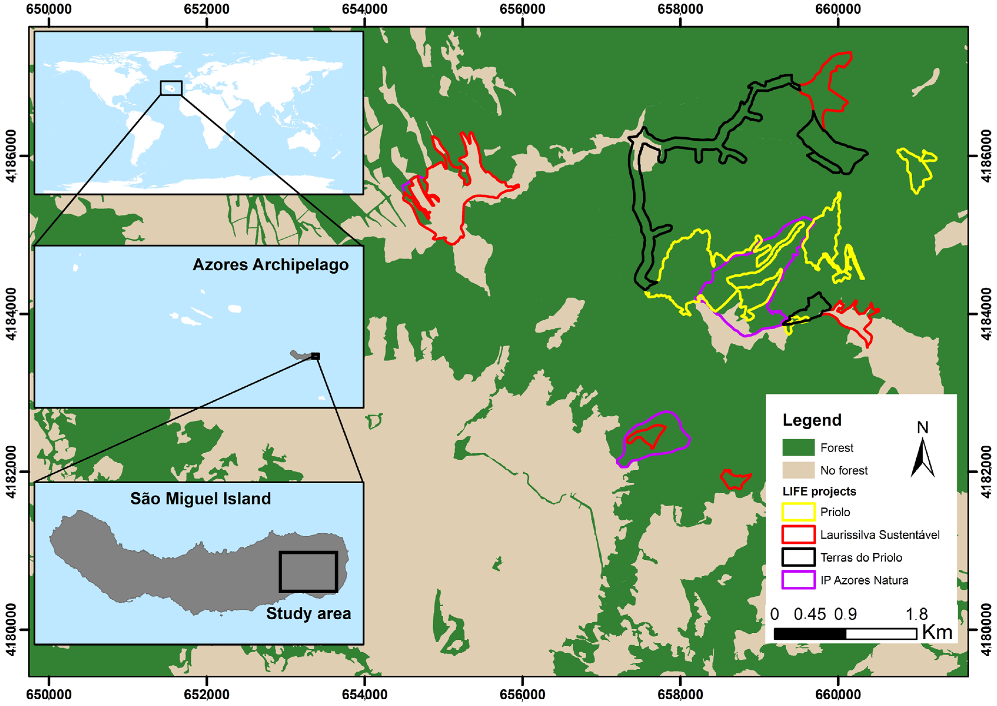
2.1. Study Area
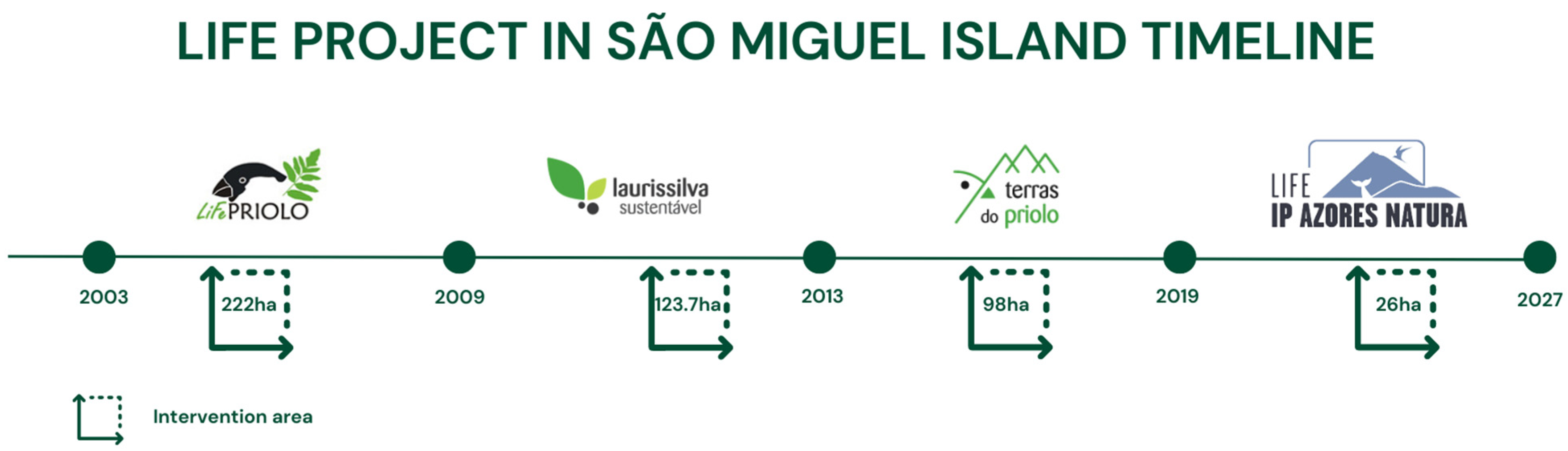
2.2. EU-Funded LIFE Nature Projects in São Miguel Island
2.3. Challenges of Satellite Remote Sensing of Islands
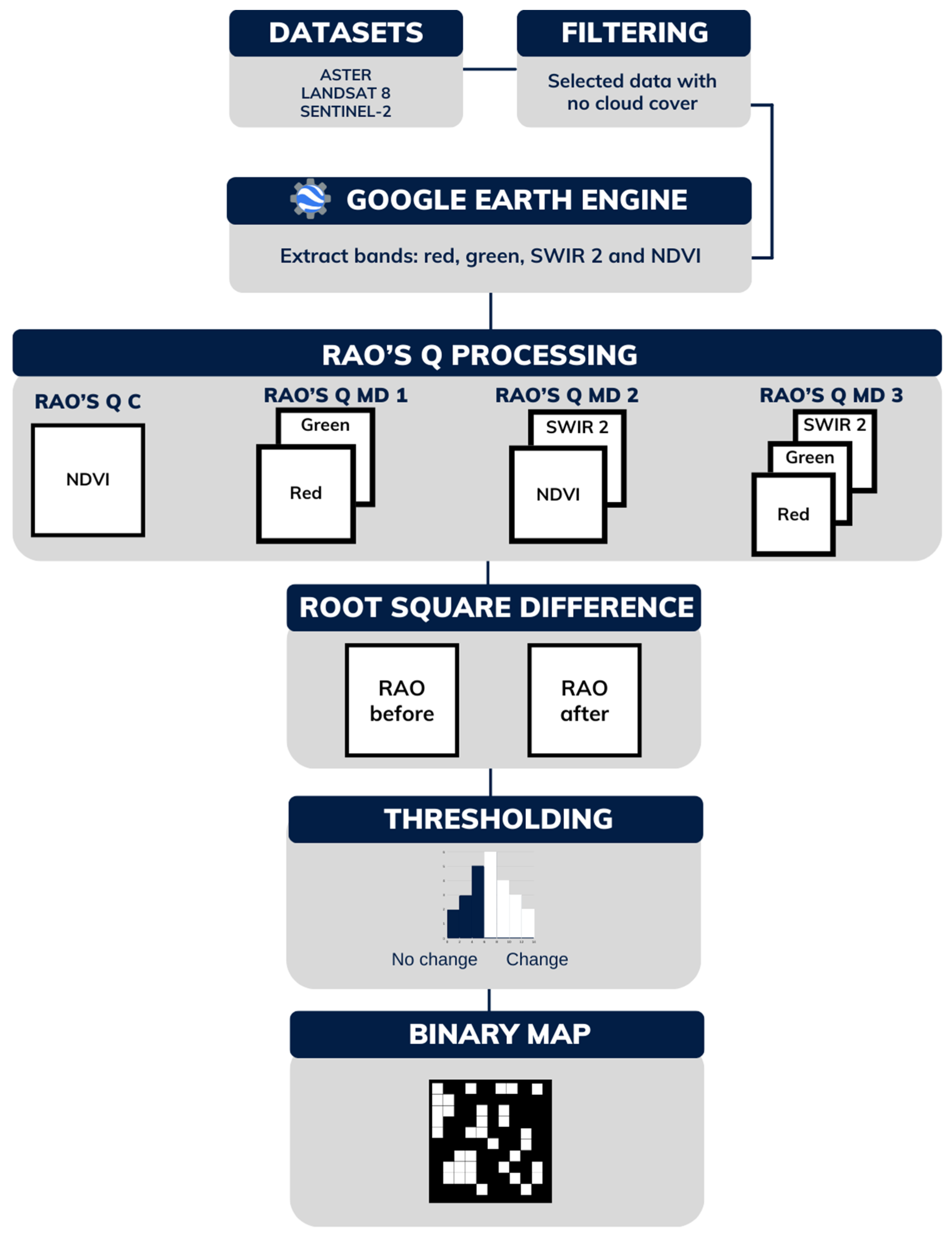
2.4. Methodological Workflow
2.4.1. NDVI Processing
2.4.2. Calculating Rao’s Q Index
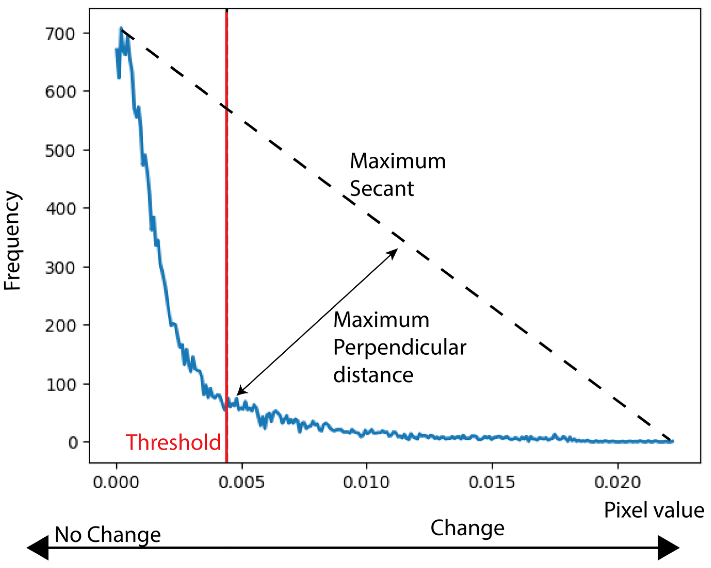
2.4.3. Threshold-Based Change Detection
2.4.4. Overall Accuracy Assessment
3. Results
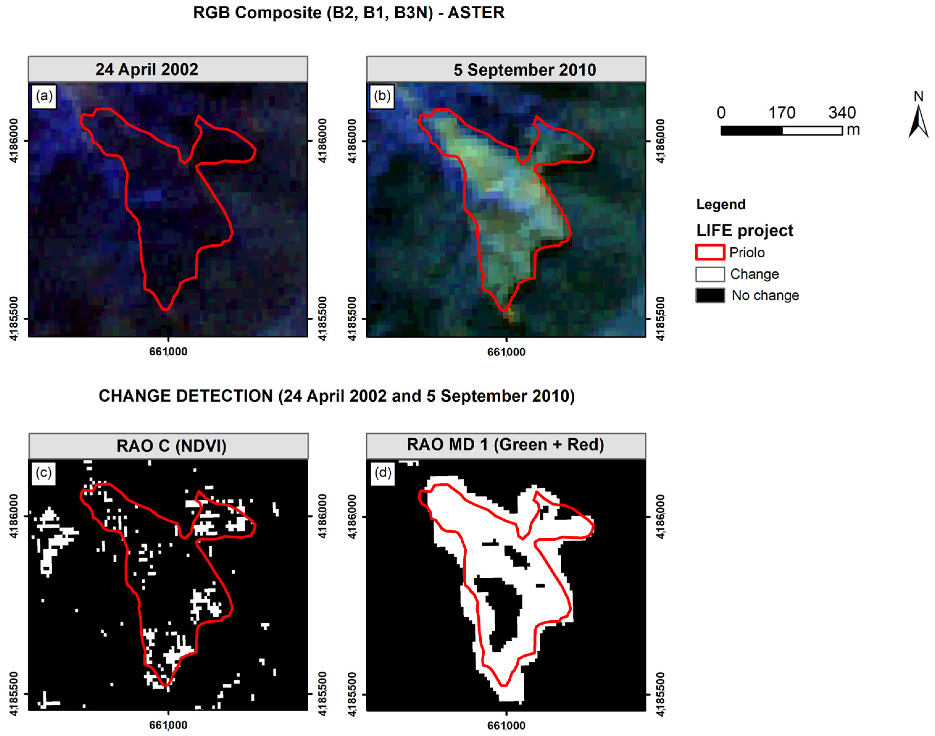
3.1. Priolo Project (2003–2008)
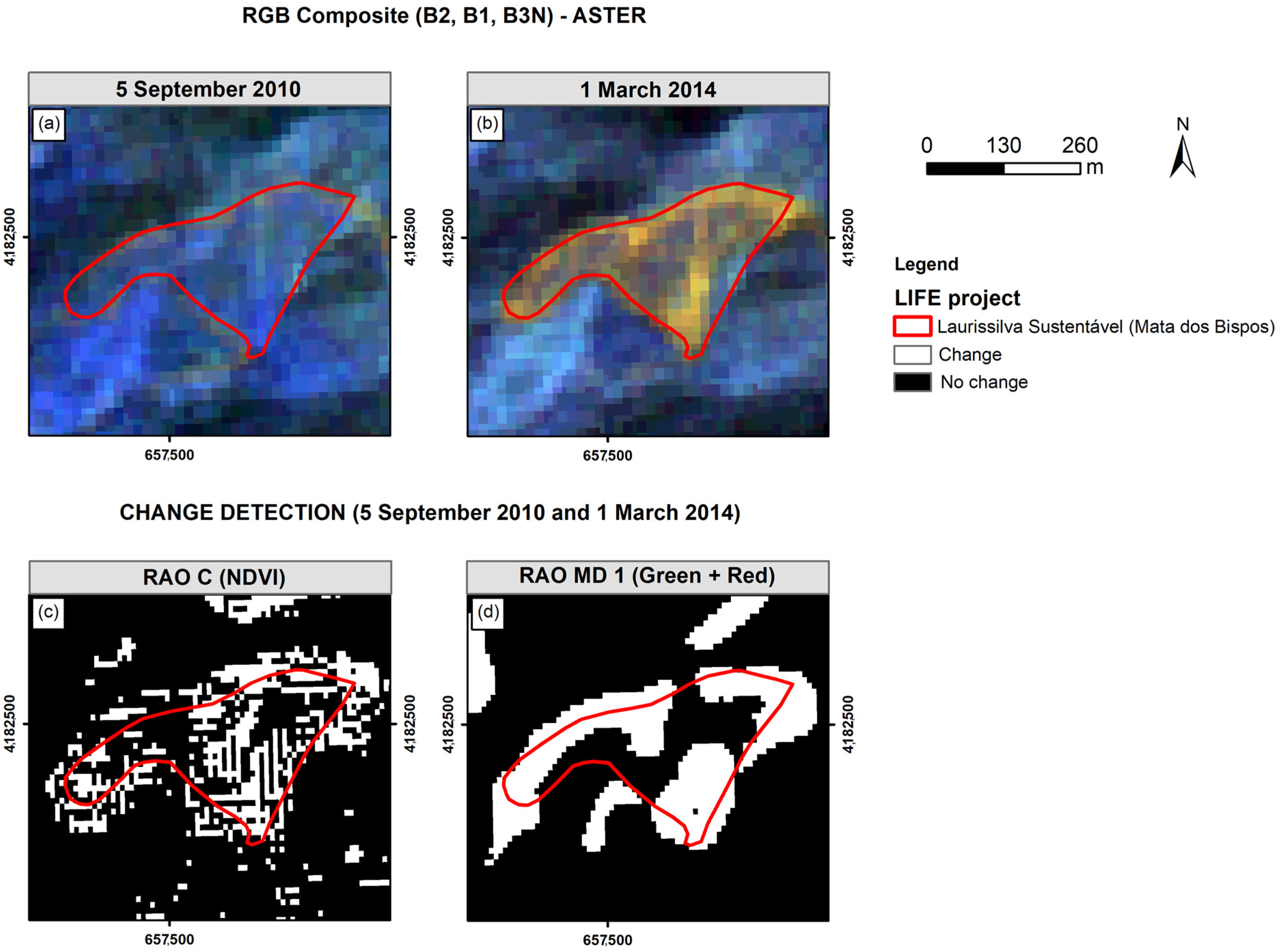
3.2. Laurissilva Sustentável Project (2009–2013)
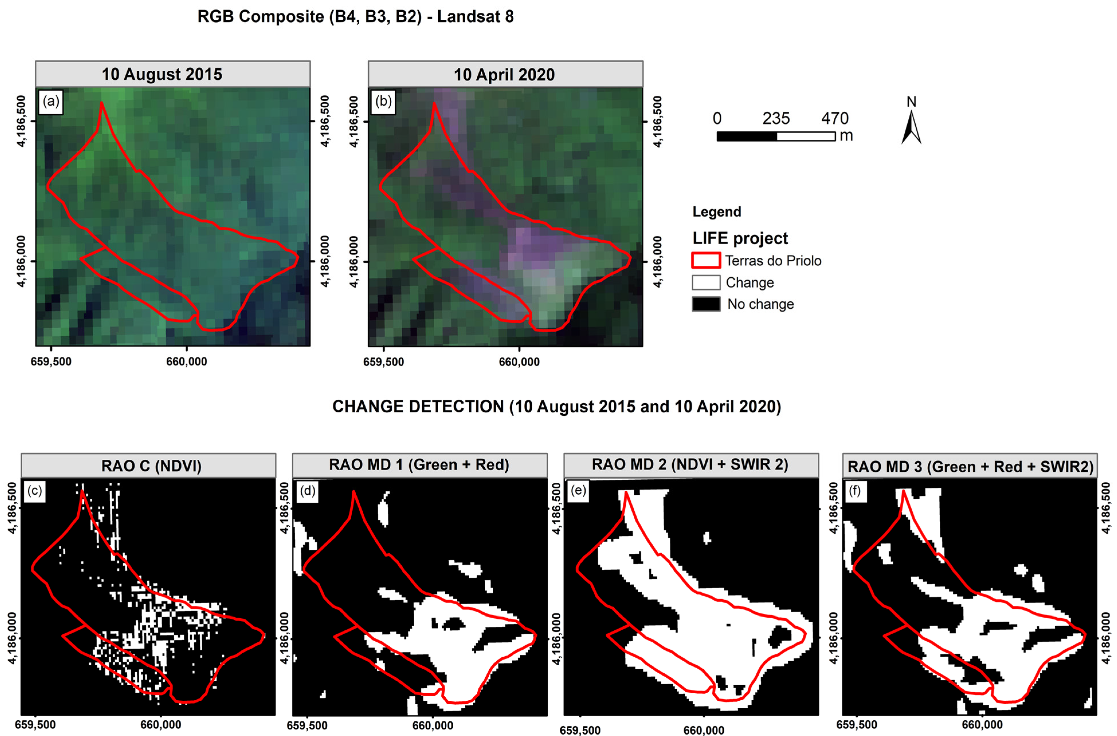
3.3. Terras do Priolo Project (2013–2019)
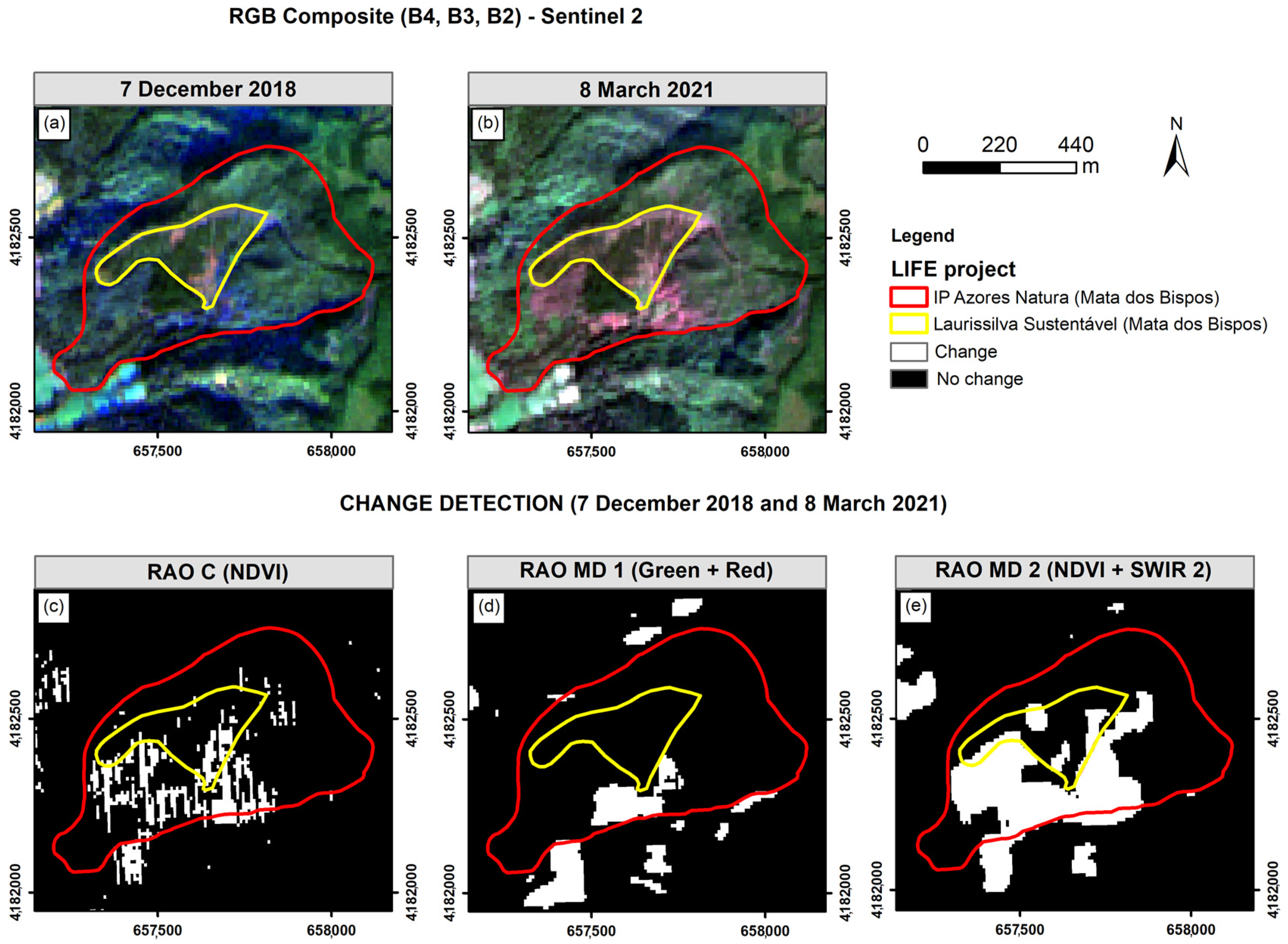
3.4. IP Azores Natura Project (2019–2027)
3.5. Overall Accuracy Assessment
4. Discussion
5. Conclusions
Author Contributions
Funding
Institutional Review Board Statement
Data Availability Statement
Acknowledgments
Conflicts of Interest
References
- Chape, S.; Harrison, J.; Spalding, M.; Lysenko, I. Measuring the Extent and Effectiveness of Protected Areas as an Indicator for Meeting Global Biodiversity Targets. Philos. Trans. R. Soc. 2005, 360, 443–455. [Google Scholar] [CrossRef]
- Rietbergen, S.; Hammond, T.; Sayegh, C.; Hesselink, F.; Mooney, K. Island Voices-Island Choices Developing Strategies for Living with Rapid Ecosystem Change in Small Islands World Headquarters International Union for Conservation of Nature Ecosystem Management Series No. 6; IUCN: Gland, Switzerland, 2008. [Google Scholar]
- Massetti, A.; Gil, A. Mapping and Assessing Land Cover/Land Use and Aboveground Carbon Stocks Rapid Changes in Small Oceanic Islands’ Terrestrial Ecosystems: A Case Study of Madeira Island, Portugal (2009–2011). Remote Sens. Environ. 2020, 239, 111625. [Google Scholar] [CrossRef]
- Gil, A.; Fonseca, C.; Benedicto-Royuela, J. Land Cover Trade-offs in Small Oceanic Islands: A Temporal Analysis of Pico Island, Azores. Land Degrad. Dev. 2018, 29, 349–360. [Google Scholar] [CrossRef]
- Thunig, H.; Wolf, N.; Naumann, S.; Siegmund, A.; Jurgens, C.; Uysal, C.; Maktav, D. Land Use/Land Cover Classification for Applied Urban Planning—The Challenge of Automation. In Proceedings of the 2011 Joint Urban Remote Sensing Event, Munich, Germany, 11–13 April 2011; IEEE: Piscataway, NJ, USA, 2011; pp. 229–232. [Google Scholar]
- Bhandari, A.; Joshi, R.; Thapa, M.S.; Sharma, R.P.; Rauniyar, S.K. Land Cover Change and Its Impact in Crop Yield: A Case Study from Western Nepal. Sci. World J. 2022, 2022, 5129423. [Google Scholar] [CrossRef]
- Setiawan, C.; Muzani, M.; Warnadi, W.; A’Rachman, F.R.; Qismaraga, Q. Analysis of Land Cover Changes after the Eruption of Mount Sinabung Using Satellite Imagery. J. Phys. Conf. Ser. 2019, 1402, 022108. [Google Scholar] [CrossRef]
- Zhao, Y.; Zhang, J.; Bai, Y.; Zhang, S.; Yang, S.; Henchiri, M.; Seka, A.M.; Nanzad, L. Drought Monitoring and Performance Evaluation Based on Machine Learning Fusion of Multi-Source Remote Sensing Drought Factors. Remote Sens. 2022, 14, 6398. [Google Scholar] [CrossRef]
- Shastry, A.; Carter, E.; Coltin, B.; Sleeter, R.; McMichael, S.; Eggleston, J. Mapping Floods from Remote Sensing Data and Quantifying the Effects of Surface Obstruction by Clouds and Vegetation. Remote Sens. Environ. 2023, 291, 113556. [Google Scholar] [CrossRef]
- Casagli, N.; Intrieri, E.; Tofani, V.; Gigli, G.; Raspini, F. Landslide Detection, Monitoring and Prediction with Remote-Sensing Techniques. Nat. Rev. Earth Environ. 2023, 4, 51–64. [Google Scholar] [CrossRef]
- Causon Deguara, J.; Gauci, R.; Inkpen, R. Monitoring Coastal Erosion Using Remote Images: Comparison between Physically and Remotely Acquired Data on a Limestone Coast. Remote Sens. 2022, 15, 36. [Google Scholar] [CrossRef]
- Forget, Y.; Shimoni, M.; Gilbert, M.; Linard, C. Mapping 20 Years of Urban Expansion in 45 Urban Areas of Sub-Saharan Africa. Remote Sens. 2021, 13, 525. [Google Scholar] [CrossRef]
- Fernandes, J.P.; Guiomar, N.; Gil, A. Strategies for Conservation Planning and Management of Terrestrial Ecosystems in Small Islands (Exemplified for the Macaronesian Islands). Environ. Sci. Policy 2015, 51, 1–22. [Google Scholar] [CrossRef]
- Costa, H.; Bettencourt, M.J.; Silva, C.M.N.; Teodósio, J.; Gil, A.; Silva, L. Invasive Alien Plants in the Azorean Protected Areas: Invasion Status and Mitigation Actions; Springer: Berlin/Heidelberg, Germany, 2013. [Google Scholar]
- Zhao, Y.; Huang, Y.; Sun, X.; Dong, G.; Li, Y.; Ma, M. Forest Fire Mapping Using Multi-Source Remote Sensing Data: A Case Study in Chongqing. Remote Sens. 2023, 15, 2323. [Google Scholar] [CrossRef]
- Achour, H.; Toujani, A.; Trabelsi, H.; Jaouadi, W. Evaluation and Comparison of Sentinel-2 MSI, Landsat 8 OLI, and EFFIS Data for Forest Fires Mapping. Illustrations from the Summer 2017 Fires in Tunisia. Geocarto Int. 2022, 37, 7021–7040. [Google Scholar] [CrossRef]
- Tiengo, R.; Palácios-Orueta, A.; Uchôa, J.; Gil, A. Remote Sensing Approaches for Land Use/Land Cover Change in Coastal Areas and Oceanic Islands: An Open Science-Based Systematic Review. Rev. Gestão Costeira Integr. 2023, 23, 155–177. [Google Scholar] [CrossRef]
- Mishra, S.; Shrivastava, P.; Dhurvey, P. Change Detection Techniques in Remote Sensing. J. Adv. Inf. Technol. Converg. 2016, 6, 51. [Google Scholar] [CrossRef]
- Panuju, D.R.; Paull, D.J.; Griffin, A.L. Change Detection Techniques Based on Multispectral Images for Investigating Land Cover Dynamics. Remote Sens. 2020, 12, 1781. [Google Scholar] [CrossRef]
- Mishra, S.; Shrivastava, P.; Dhurvey, P. Change Detection Techniques in Remote Sensing: A Review. Int. J. Wirel. Mob. Commun. Ind. Syst. 2017, 4, 1–8. [Google Scholar] [CrossRef]
- Wright, D.; Harder, C. GIS for Science: Applying Mapping and Spatial Analytics, 1st ed.; Esri Press: Redlands, CA, USA, 2019; Volume 1. [Google Scholar]
- Bannari, A.; Morin, D.; Bonn, F.; Huete, A.R. A Review of Vegetation Indices. Remote Sens. Rev. 1995, 13, 95–120. [Google Scholar] [CrossRef]
- Rocchini, D.; Marcantonio, M.; Da Re, D.; Bacaro, G.; Feoli, E.; Foody, G. From Zero to Infinity: Minimum to Maximum Diversity of the Planet by Spatio-Parametric Rao’s Quadratic Entropy. Glob. Ecol. Biogeogr. 2021, 30, 1153–1162. [Google Scholar] [CrossRef]
- Khare, S.; Latifi, H.; Rossi, S. A 15-Year Spatio-Temporal Analysis of Plant β-Diversity Using Landsat Time Series Derived Rao’s Q Index. Ecol. Indic. 2021, 121, 107105. [Google Scholar] [CrossRef]
- Tassi, A.; Gil, A. A Low-Cost Sentinel-2 Data and Rao’s Q Diversity Index-Based Application for Detecting, Assessing and Monitoring Coastal Land-Cover/Land-Use Changes at High Spatial Resolution. J. Coast. Res. 2020, 95, 1315. [Google Scholar] [CrossRef]
- Tassi, A.; Massetti, A.; Gil, A. The Spectralrao-Monitoring Python Package: A RAO’s Q Diversity Index-Based Application for Land-Cover/Land-Use Change Detection in Multifunctional Agricultural Areas. Comput. Electron. Agric. 2022, 196, 106861. [Google Scholar] [CrossRef]
- Michele, T.; Duccio, R.; Marc, Z.; Ruth, S.; Giustino, T. Testing the Spectral Variation Hypothesis by Using the RAO-Q Index to Estimate Forest Biodiversity: Effect of Spatial Resolution. In Proceedings of the IGARSS 2018—2018 IEEE International Geoscience and Remote Sensing Symposium, Valencia, Spain, 22–27 July 2018; IEEE: Piscataway, NJ, USA, 2018; pp. 1183–1186. [Google Scholar]
- Liccari, F.; Sigura, M.; Bacaro, G. Use of Remote Sensing Techniques to Estimate Plant Diversity within Ecological Networks: A Worked Example. Remote Sens. 2022, 14, 4933. [Google Scholar] [CrossRef]
- Rocchini, D.; Marcantonio, M.; Ricotta, C. Measuring Rao’s Q Diversity Index from Remote Sensing: An Open Source Solution. Ecol. Indic. 2017, 72, 234–238. [Google Scholar] [CrossRef]
- Khare, S.; Latifi, H.; Rossi, S. Forest Beta-Diversity Analysis by Remote Sensing: How Scale and Sensors Affect the Rao’s Q Index. Ecol. Indic. 2019, 106, 105520. [Google Scholar] [CrossRef]
- Rocchini, D.; Marcantonio, M.; Da Re, D.; Chirici, G.; Galluzzi, M.; Lenoir, J.; Ricotta, C.; Torresani, M.; Ziv, G. Time-Lapsing Biodiversity: An Open Source Method for Measuring Diversity Changes by Remote Sensing. Remote Sens. Environ. 2019, 231, 111192. [Google Scholar] [CrossRef]
- Jornal Oficial das Comunidades Europeias. European Commission Council Regulation (EEC) No 1973/92. Off. J. Eur. Communities 1992, 35, 1–6. [Google Scholar]
- SPEA. Priolo LIFE: Recuperação Do Habitat. Do Priolo Na Zpe Picoda Vara/Ribeira Do Guilherme; Sociedade Portuguesa para o Estudo das Aves: Lisboa, Portugal, 2009. [Google Scholar]
- SPEA. Relatório Final Do Projeto LIFE+ Laurissilva Sustentável (LIFE07 ENV/P/000630); Sociedade Portuguesa para o Estudo das Aves: Lisboa, Portugal, 2013; pp. 3–56. [Google Scholar]
- SPEA. Relatório Final Do Projeto LIFE+ Terras Do Priolo—Proteção Ativa Da População Do Priolo e Seus Habitats e Gestão Sustentável Das ZPE Do Pico Da Vara/Ribeira Do Guilherme; Sociedade Portuguesa para o Estudo das Aves: Lisboa, Portugal, 2020. [Google Scholar]
- SPEA. Plano Operacional Da Mata Dos Bispos, São Miguel—Versão 1.0 Projeto LIFE IP AZORES NATURA—Proteção Ativa e Gestão Integrada Da Rede Natura 2000 Nos Açores; Azores: Nordeste, Portugal, 2020. [Google Scholar]
- Botelho, R.; De la Cruz, A.; Figueiredo, F.; Costa, T.; Mendonça, A.; Amaral, A.; Marquez, B.; Teixeira, R. Priolo, Como a Conservação de Uma Espécie Pode Alterar a Gestão de Um Território.
- de Costa, T.M.M.; Gil, A.; Timóteo, S.; Ceia, R.S.; Coelho, R.; de la Cruz Martin, A. How Many Azores Bullfinches (Pyrrhula Murina) Are There in the World? Case Study of a Threatened Species. Diversity 2023, 15, 685. [Google Scholar] [CrossRef]
- Gil, A.; Fonseca, C.; Lobo, A.; Calado, H. Linking GMES Space Component to the Development of Land Policies in Outermost Regions—The Azores (Portugal) Case-Study. Eur. J. Remote Sens. 2012, 45, 263–281. [Google Scholar] [CrossRef]
- Gorelick, N.; Hancher, M.; Dixon, M.; Ilyushchenko, S.; Thau, D.; Moore, R. Google Earth Engine: Planetary-Scale Geospatial Analysis for Everyone. Remote Sens. Environ. 2017, 202, 18–27. [Google Scholar] [CrossRef]
- Kumar, L.; Mutanga, O. Google Earth EngineApplications Since Inception: Usage, Trends and Potential. Remote Sens. 2018, 10, 1509. [Google Scholar] [CrossRef]
- Navarro, J. First Experiences with Google EarthEngine. In Proceedings of the 3rd International Conference on Geographical Information Systems Theory, Applications and Management, Porto, Portugal, 27–28 April 2017. [Google Scholar]
- Beller, W.; Beller, W.S.; D’Ayala, P.G.; Hein, P. Sustainable Development and Environmental Management of Small Islands; UNESCO: Lancashire, UK, 1990; Volume 5. [Google Scholar]
- Tucker, C.J. Red and Photographic Infrared Linear Combinations for Monitoring Vegetation. Remote Sens. Environ. 1979, 8, 127–150. [Google Scholar] [CrossRef]
- Jena, J.; Misra, S.R.; Tripathi, K. Normalized Difference Vegetation Index (NDVI) and Its Role in Agriculture. Agric. Food 2019, 1, 387–389. [Google Scholar]
- Tenreiro, T.R.; García-Vila, M.; Gómez, J.A.; Jiménez-Berni, J.A.; Fereres, E. Using NDVI for the Assessment of Canopy Cover in Agricultural Crops within Modelling Research. Comput. Electron. Agric. 2021, 182, 106038. [Google Scholar] [CrossRef]
- Sruthi, S.; Aslam, M.A.M. Agricultural Drought Analysis Using the NDVI and Land Surface Temperature Data; a Case Study of Raichur District. Aquat. Procedia 2015, 4, 1258–1264. [Google Scholar] [CrossRef]
- Matas-Granados, L.; Pizarro, M.; Cayuela, L.; Domingo, D.; Gómez, D.; García, M.B. Long-Term Monitoring of NDVI Changes by Remote Sensing to Assess the Vulnerability of Threatened Plants. Biol. Conserv. 2022, 265, 109428. [Google Scholar] [CrossRef]
- Skarlatos, D.; Vlachos, M. Vegetation Removal from UAV Derived DSMS, Using Combination of RGB and NIR Imagery. Remote Sens. Spat. Inf. Sci. 2018, IV-2, 255–262. [Google Scholar] [CrossRef]
- Roy, B. Assssment of Vegetation Health in Saint Martins Island, Bangladesh Using Remote Sensing and GIS. Int. J. Innov. Eng. Res. Technol. 2020, 7, 87–89. [Google Scholar] [CrossRef]
- Thouverai, E.; Marcantonio, M.; Bacaro, G.; Da Re, D.; Iannacito, M.; Marchetto, E.; Ricotta, C.; Tattoni, C.; Vicario, S.; Rocchini, D. Measuring Diversity from Space: A Global View of the Free and Open Source Rasterdiv R Package under a Coding Perspective. Community Ecol. 2021, 22, 1–11. [Google Scholar] [CrossRef]
- Lillesand, T.M.; Kiefer, R.W. Remote Sensing and Image Interpretation; John Wiley & Sons: Hoboken, NJ, USA, 2000; Volume 736. [Google Scholar]
- Shivakumar, R.; Rajashekararadhya, S. An Investigation on Land Cover Mapping Capability of Classical and Fuzzy Based Maximum Likelihood Classifiers. Int. J. Eng. Technol. 2018, 7, 939. [Google Scholar] [CrossRef]
- Richards, J.A. (Ed.) Remote Sensing Digital Image Analysis, 5th ed.; Springer: Berlin/Heidelberg, Germany, 2013; 494p, ISBN 978-3-642-30061-5. [Google Scholar]
- Okwuashi, O.; Isong, M.; Eyo, E.; Eyoh, A.; Nwanekezie, O.; Olayinka, D.N.; Udoudo, D.O.; Ofem, B. GIS Cellular Automata Using Artificial Neural Network for Land Use Change Simulation of Lagos, Nigeria. J. Geogr. Geol. 2012, 4, 94–101. [Google Scholar] [CrossRef]
- SPEA. Recuperação Do Habitat Do Priolo Na ZPE Pico Da Vara/Ribeira Do Guilherme. LIFE 03NAT/P/000013. Relatório Final; SPEA: Lisboa, Portugal, 2009. [Google Scholar]
- Motohka, T.; Nasahara, K.N.; Oguma, H.; Tsuchida, S. Applicability of Green-Red Vegetation Index for Remote Sensing of Vegetation Phenology. Remote Sens. 2010, 2, 2369–2387. [Google Scholar] [CrossRef]
- Cimtay, Y.; Ozbay, B.; Yilmaz, G.N.; Bozdemir, E. A New Vegetation Index in Short-Wave Infrared Region of Electromagnetic Spectrum. IEEE Access 2021, 9, 148535–148545. [Google Scholar] [CrossRef]
- Mayer, R.R.; Scribner, D.A. Extending the Normalized Difference Vegetation Index (NDVI) to Short-Wave Infrared Radiation (SWIR) (1- to 2.5-Μm); Shen, S.S., Ed.; SPIE: Bellingham, DC, USA, 2002; p. 182. [Google Scholar]


| Rao’s Q Classic (ASTER, L8, and S2) | Rao’s Q MD 1 (ASTER, L8, and S2) | Rao’s Q MD 2 (L8 and S2) | Rao’s Q MD 3 (L8 and S2) |
|---|---|---|---|
| NDVI | Red + Green | NDVI + SWIR2 | Red + Green + SWIR 2 |
| Study Area (Sensor) | Rao’s Q Classic (NDVI) | Rao’s Q MD 1 (Green + Red) | Rao’s Q MD 2 (NDVI + SWIR2) | Rao’s Q MD 3 (Green + Red + SWIR2) |
|---|---|---|---|---|
| Priolo (ASTER) | 62 | 83 | ||
| Laurissilva Sustentável (ASTER) | 73 | 79 | ||
| Terras do Priolo (L8) | 64 | 74 | 94 | 74 |
| IP Azores Natura (S2) | 88 | 60 | 91 | 68 |
Disclaimer/Publisher’s Note: The statements, opinions and data contained in all publications are solely those of the individual author(s) and contributor(s) and not of MDPI and/or the editor(s). MDPI and/or the editor(s) disclaim responsibility for any injury to people or property resulting from any ideas, methods, instructions or products referred to in the content. |
© 2024 by the authors. Licensee MDPI, Basel, Switzerland. This article is an open access article distributed under the terms and conditions of the Creative Commons Attribution (CC BY) license (https://creativecommons.org/licenses/by/4.0/).
Share and Cite
Tiengo, R.; Merino-De-Miguel, S.; Uchôa, J.; Gil, A. A Land Cover Change Detection Approach to Assess the Effectiveness of Conservation Projects: A Study Case on the EU-Funded LIFE Projects in São Miguel Island, Azores (2002–2021). Land 2024, 13, 666. https://doi.org/10.3390/land13050666
Tiengo R, Merino-De-Miguel S, Uchôa J, Gil A. A Land Cover Change Detection Approach to Assess the Effectiveness of Conservation Projects: A Study Case on the EU-Funded LIFE Projects in São Miguel Island, Azores (2002–2021). Land. 2024; 13(5):666. https://doi.org/10.3390/land13050666
Chicago/Turabian StyleTiengo, Rafaela, Silvia Merino-De-Miguel, Jéssica Uchôa, and Artur Gil. 2024. "A Land Cover Change Detection Approach to Assess the Effectiveness of Conservation Projects: A Study Case on the EU-Funded LIFE Projects in São Miguel Island, Azores (2002–2021)" Land 13, no. 5: 666. https://doi.org/10.3390/land13050666
APA StyleTiengo, R., Merino-De-Miguel, S., Uchôa, J., & Gil, A. (2024). A Land Cover Change Detection Approach to Assess the Effectiveness of Conservation Projects: A Study Case on the EU-Funded LIFE Projects in São Miguel Island, Azores (2002–2021). Land, 13(5), 666. https://doi.org/10.3390/land13050666