
Integrating Heritage and Environment: Characterization of Cultural Landscape in Beijing Great Wall Heritage Area


Abstract
1. Introduction
2. Literature Review
2.1. Holistic Conservation of Heritage Areas
2.2. Landscape Character Assessment (LCA)
2.3. The Great Wall’s Heritage Value
3. Materials and Methods
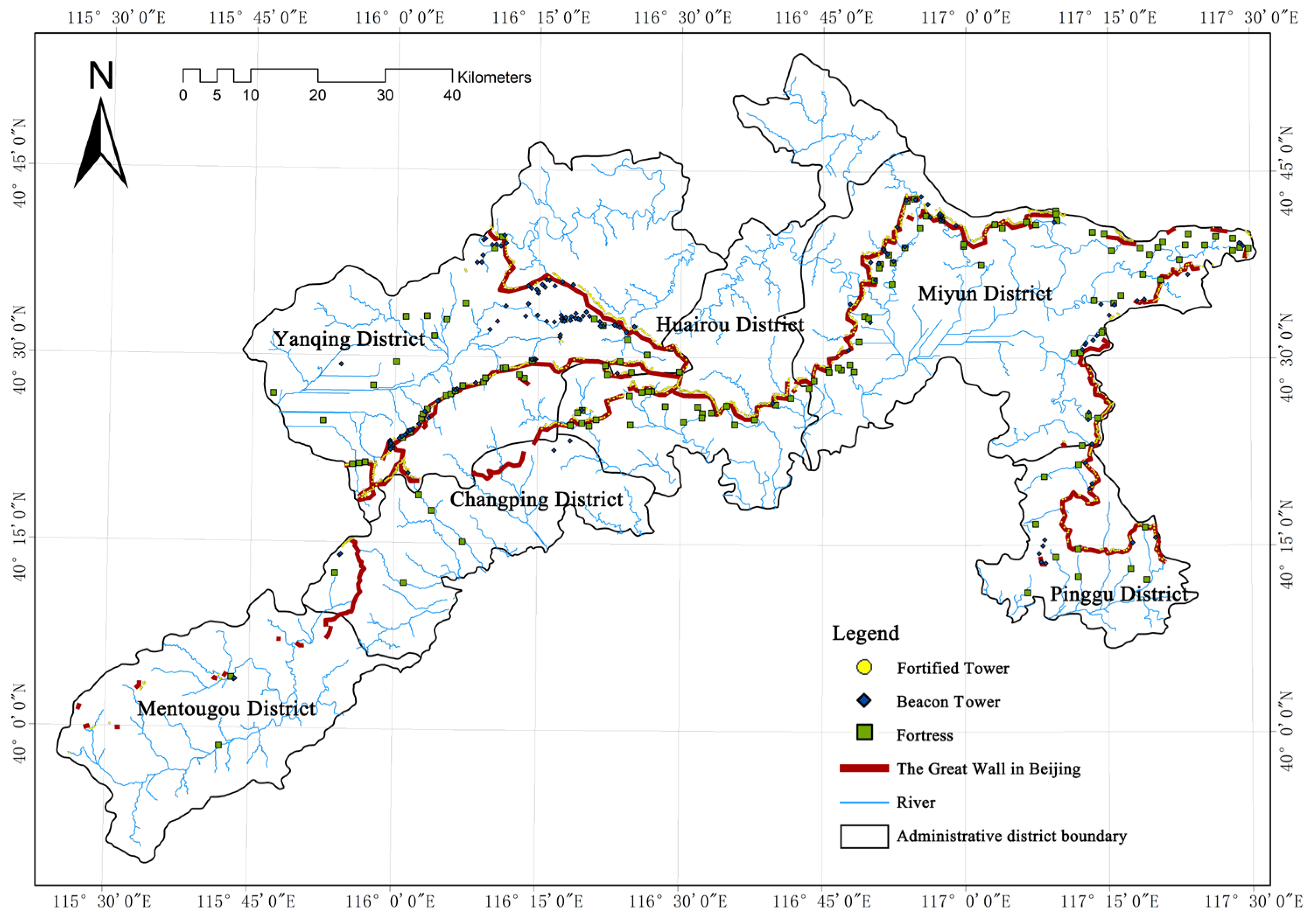
3.1. Study Area
3.2. Landscape Character Assessment Based on the Coupling of Heritage and the Environment
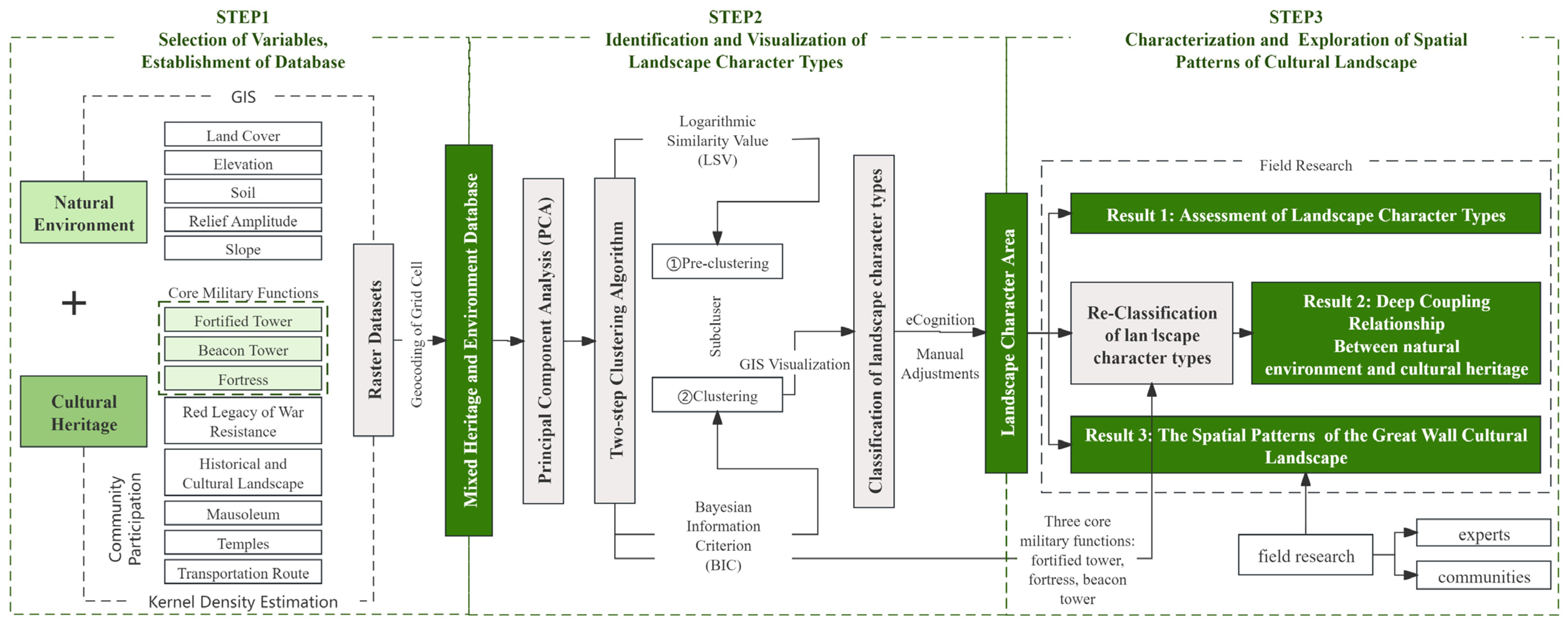
3.2.1. Methodology
3.2.2. Selection of Variables and Establishment of Database
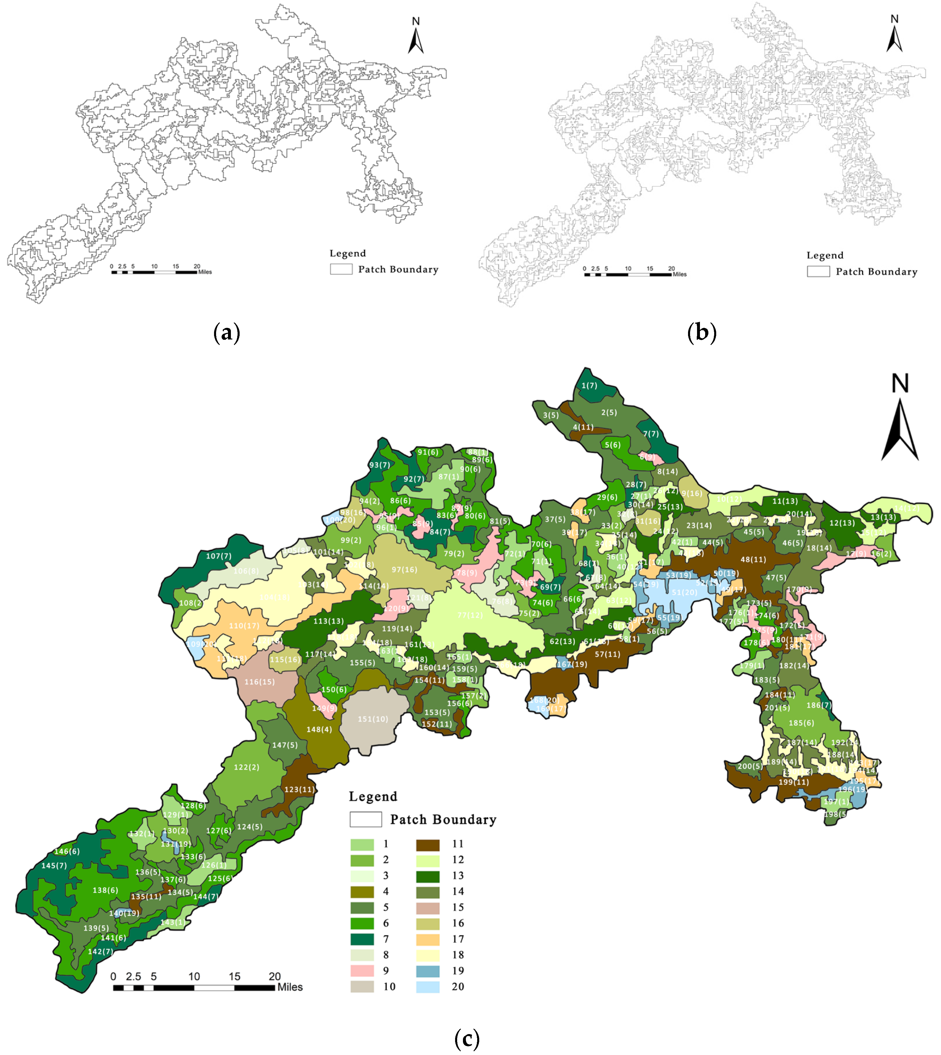
3.2.3. Identification and Visualization of Landscape Character Types
3.2.4. Characterization and Exploration of Spatial Patterns of the Cultural Landscape
4. Results
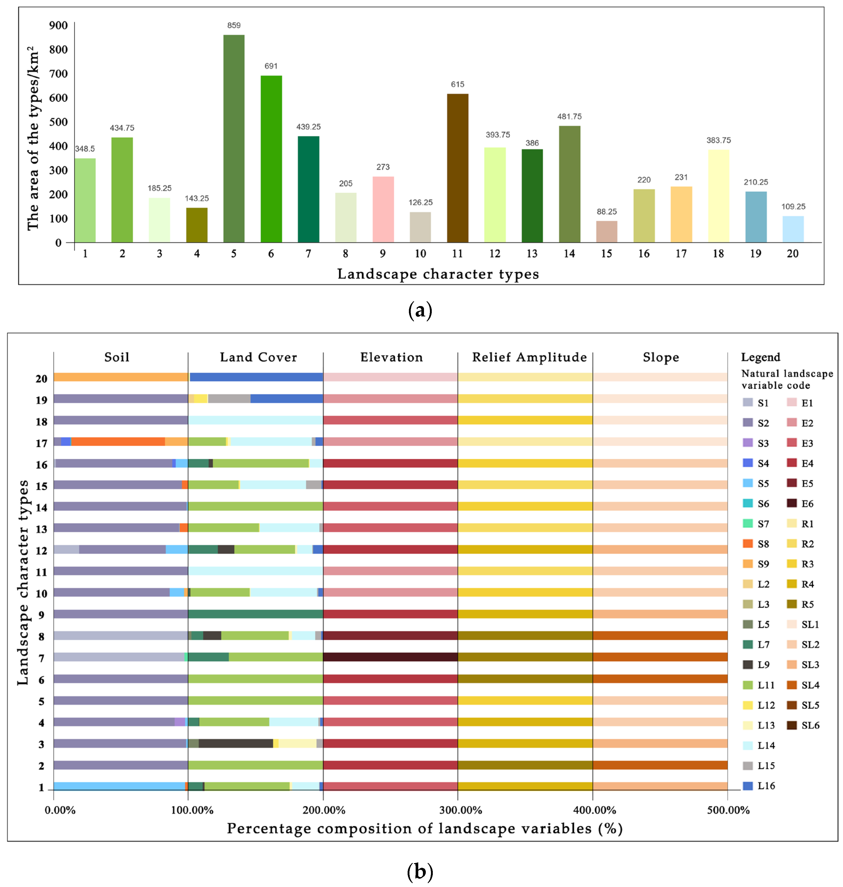
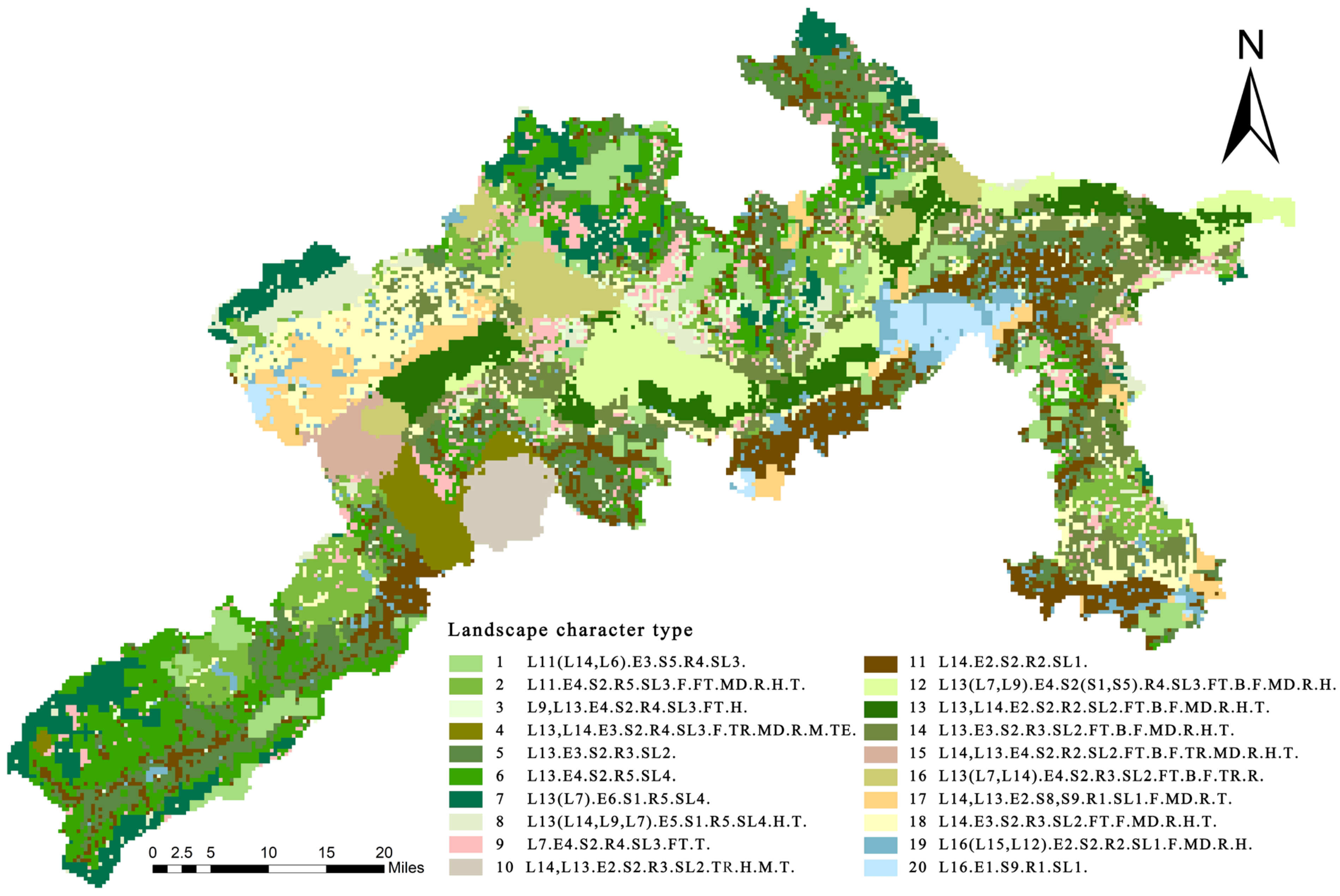
4.1. Zoning and Description of Landscape Character Types
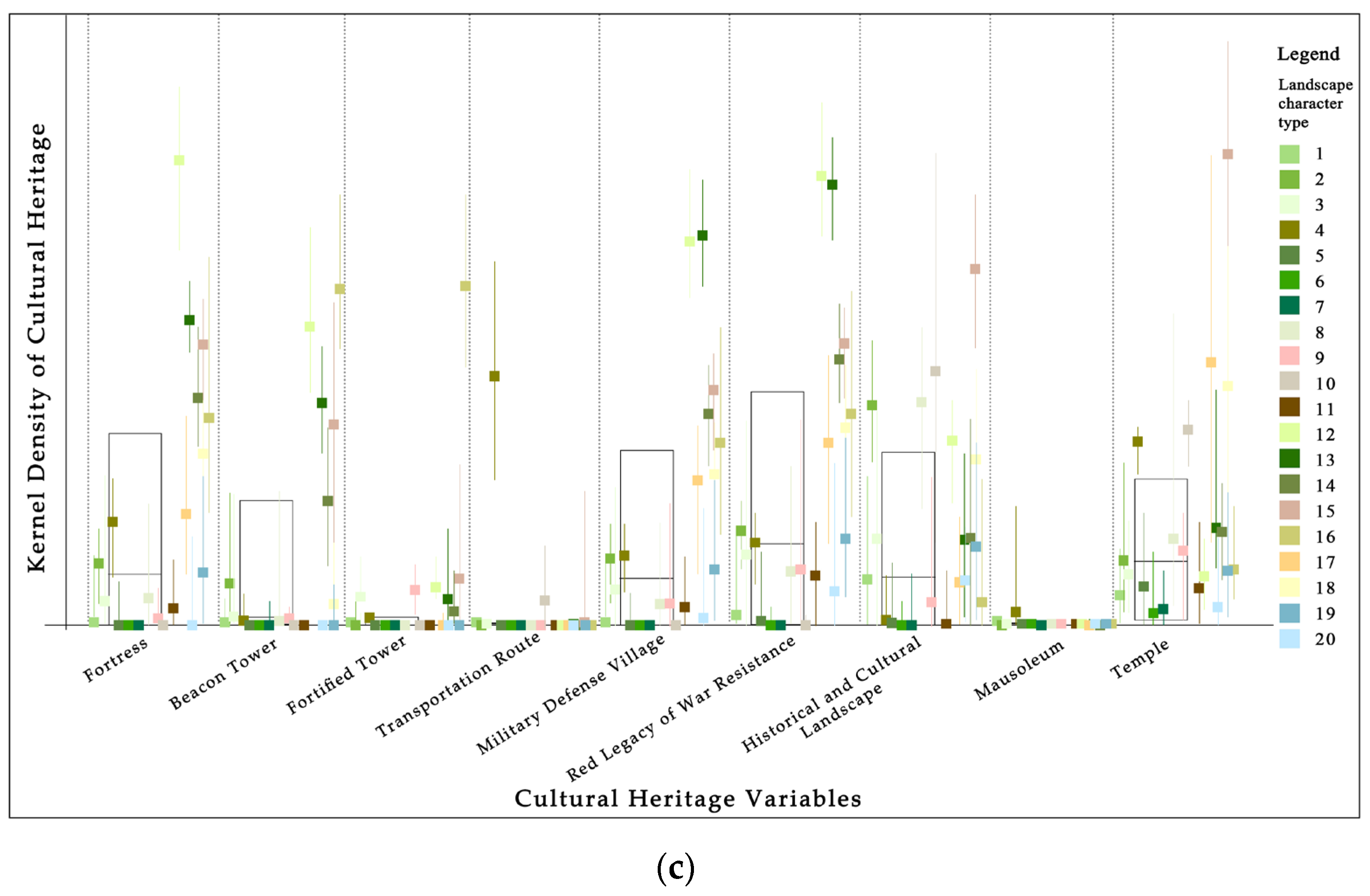
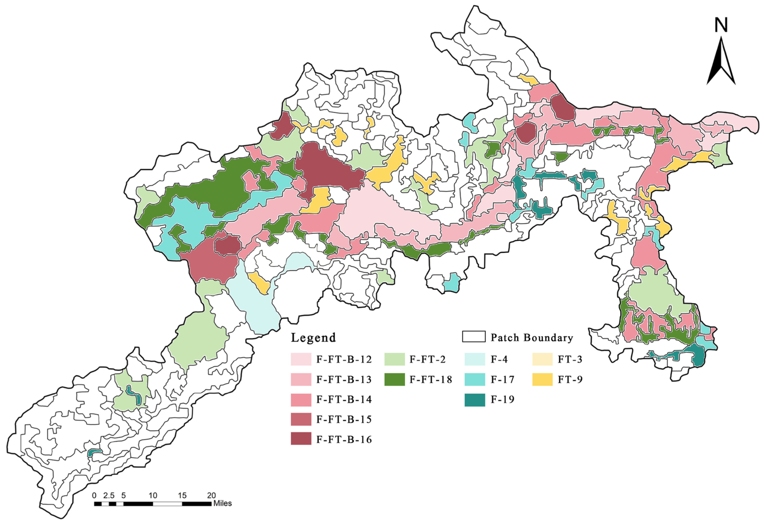
4.2. Coupling of the Cultural Heritage and the Natural Environment in the Core Area of the Great Wall Heritage Site (Reclassification)
4.3. Spatial Patterns of the Cultural Landscape in the Core Area of the Beijing Great Wall heritage Site
5. Discussion
5.1. Landscape Management Based on Coupled Nature–Culture Relationships
5.2. Planning and Designing Based on Natural–Cultural Spatial Patterns
5.3. Historic Landscape Character Study Based on Landscape Archaeology and Historical Documents
5.4. Limitations and Future Research
6. Conclusions
Author Contributions
Funding
Data Availability Statement
Conflicts of Interest
Appendix A

| Type | Description |
|---|---|
| 1 | Surrounded by steep mountainous areas with an average elevation of around 600 m, there are large areas of grassland accompanied by small amounts of construction land and artificial evergreen coniferous forests. The soil type is all skeletal soil, not suitable for agricultural use and treatment. The largest patch is located in the northwestern corner, which is a mountainous ecological conservation area and the location of the Beijing Silica Trees National Geopark. Surrounded by mountains on all sides, the park contains numerous geological, anthropogenic, and natural landscapes and is the only national geopark in North China with typical rare and precious silica tree groups as its main landscape. |
| 2 | Located in a treacherous mountainous area with an average elevation of about 750 m, the unique terrain presents more fortified towers and fortresses to match, historically, the offense and defense efforts in this area. The southwestern corner of the patch is located in the Changyu Fortress, a military fortress of the Ming Dynasty, built in a high mountain valley, next to the White Sheep Fortress, which constitutes the defense line of the Northwest Border Pass. In ancient times, it was a place to resist the invasion of northern nomads, and, in more modern times, it has been a battlefield against Japanese invaders. |
| 3 | Patches are scattered throughout the map. The fortified towers are distributed in a continuous line in the steep mountainous area, with forest vegetation formed by deciduous coniferous forest and deciduous broad-leaved forest with a small amount of wetland distributed on both sides. Nearby are more historical and cultural landscapes such as the Liuli River (the site of China’s early Western Zhou capital) and the Qifeng Mountain (strange peaks, pines, and springs). |
| 4 | Numerous fortresses are located in areas of high relief and low elevation, and the area presents a unique landscape type in the Beijing Great Wall region. The only patch is located in the “Juyongguan Pass Ravine”. This 20 km long ravine is surrounded by two mountains, in the east and west, with steep cliffs and narrow roads, making the terrain very dangerous. Therefore, the main road of the Guan Gou including the Shangguan Fortress, the Juyongguan Fortress, the Nankou Fortress, and the Badaling Fortress together constitute the Guan Gou military defense system. |
| 5 | It is located in a grassy hilly area far from the Great Wall heritage site; the average elevation is around 500 m above the sea level; and the main soil type is brown soil, located on higher ground with a certain slope, well drained, and suitable for fruit trees and crops. |
| 6 | It is located in the Meadow Mountain area, which is far away from the heritage assets of the Great Wall, and the average altitude is around 800 m, with high vegetation coverage, mostly nature reserves, a low population density, and less human interference. |
| 7 | It is located in a high-altitude mountainous area far from the Great Wall heritage site, with an average elevation of around 1100 m. The surrounding landscape is dominated by meadows and woodlands. Influenced by the altitude, the soil type of the area is brown soil, which is an important forest soil type suitable for the development of forestry, with a large number of oak and pine trees distributed in this area. |
| 8 | It is located in a high-altitude mountainous area far away from the Great Wall heritage site, with an average elevation of about 1000 m. The surrounding landscape is rich and diverse, dominated by grasslands, with a small amount of construction land, artificial evergreen coniferous forests, and artificial deciduous coniferous forests. The Beijing Songshan National Nature Reserve and part of the Yudu Mountain Scenic Area are distributed within this plot, with rich historical and cultural landscapes, monasteries, and temples. |
| 9 | The fortified towers are distributed in the steep mountainous terrain, with an average elevation of around 700 m. The surrounding landscape is dominated by artificial evergreen coniferous forests, and there are temples such as the Nine Immortals’ Temple and the Guandi Temple within this plot of land. |
| 10 | The patches are all located in the area of Beijing’s Ming Thirteen Tombs, a complex of burial buildings for Ming emperors, with multiple mausoleum burial sites, listed as a World Heritage Site in 2003. The mausoleum area is surrounded by mountains on three sides and has a vast territory, with the emperors’ tombs staggered in the middle basin, which was regarded as a feng shui site by the Ming Dynasty and was planted with evergreen pine and cypress trees. A large number of villages exist around the mausoleum, most of which are the descendants of the guardians of the mausoleum. Within the mausoleum area, there are cultural heritage sites such as the Thirteen Mausoleums’ Sacred Path (postal transportation road), the Shuigouquan Memorial Forest (historical and cultural landscape), and the Longwangmiao (temple) of Jingling Village. The construction of the Thirteen Mausoleums was closely related to the Great Wall, large sections of which were built not only to guard the capital but also to serve as an important gateway to guard the Thirteen Ming Tombs. |
| 11 | Located in a combination of low mountains and plains, there are the Xiong’erying Fortress and the Zhaitang Fortress. The Zhaitang Fortress is located on a terrain that is relatively flat and is west of Beijing with respect to the main transportation and old trade routes, as the Ming Dynasty built this fortress to guard the ancient road running through it. The Zhaitang Fortress is rich in historical and cultural resources: there are the Lingyue Temple, Ming and Qing Dynasty ancient residential villages, and other historical relics in the city. |
| 12 | Located in a steep mountainous area, the surrounding land types are grassland, artificial evergreen coniferous forests, and artificial deciduous coniferous forests, with more than 90% of vegetation cover and rich soil types. The central patch is the location of the “Beijing Knot” of the Arrowbolt Great Wall, which is the meeting point of the three Great Walls. This section of the Great Wall is the most treacherous and majestic section of the Great Wall in Beijing, with a unique architectural style and a dense number of fortified towers, and it was an important gate to guard the capital and the imperial tombs in the Ming Dynasty. |
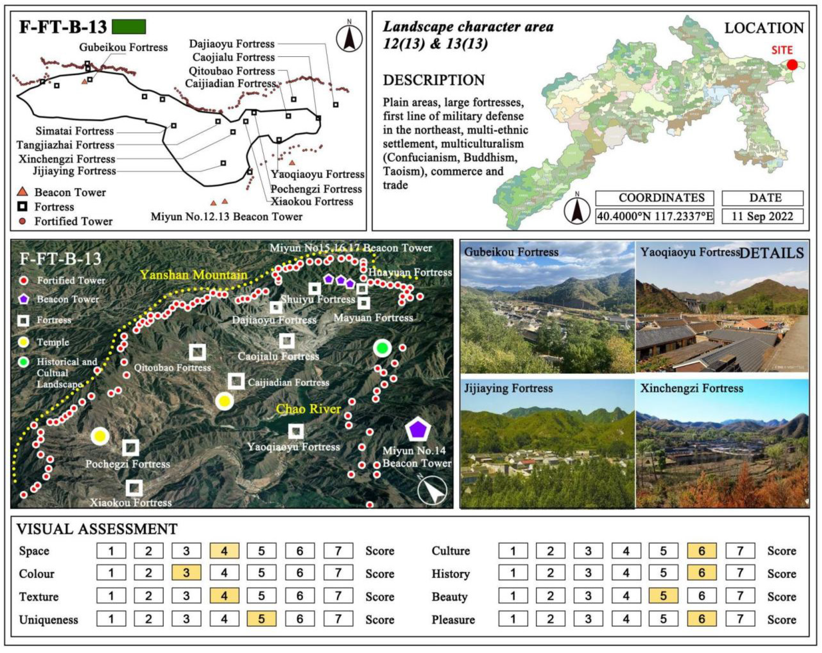
| 13 | It is located in a hilly area with a low terrain, surrounded by grasslands and construction sites. The central part of this area is the site of the Huanghua Fortress and the Bohai Fortress, and, in order to strengthen the defense, a defense system was formed with the most important fortress (Yellow Flower Fortress) as the military command center, with the related facilities (fortified towers and beacon towers) around it and smaller surrounding fortresses. The place was named Yellow Flower Great Wall (黄花城) because of the yellow flowers on the mountains, and it is also called the Water Great Wall because there are three sections of the Great Wall that enter the water, i.e., the lake disconnects the Great Wall, creating a strange landscape, with the Great Wall playing with water. |
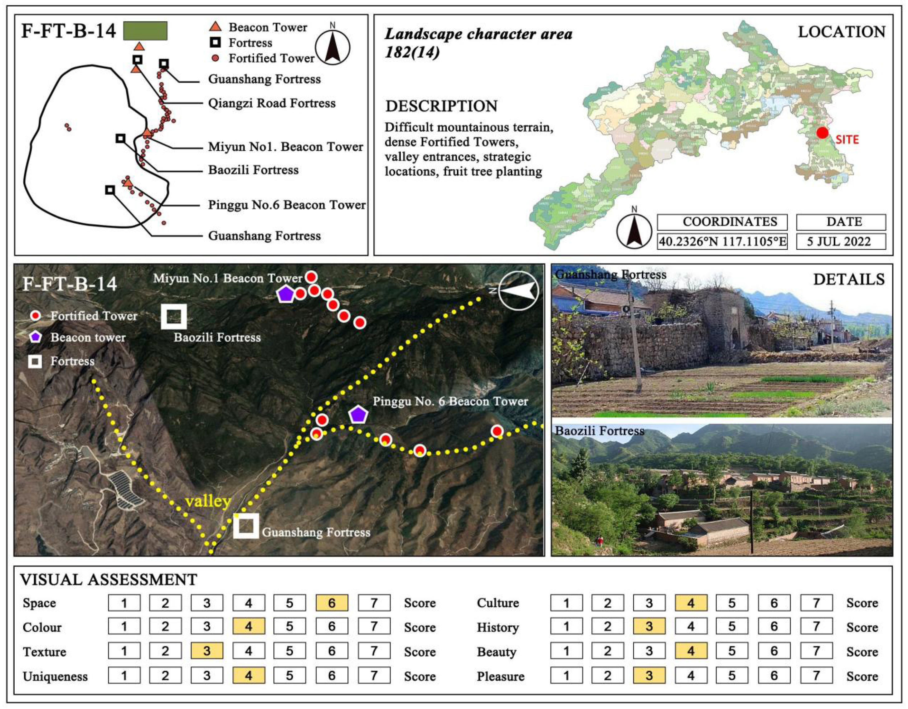
| 14 | It is located at the edge of the core conservation area of the Great Wall, with great reliefs, an average elevation of about 500 m, and the land type being mainly grassland. The facilities related to fortresses, fortified towers, and beacon towers form a complete and tight military defense system. In addition to the facilities of the Great Wall itself, there are many military defense villages, historical and cultural landscapes, and temples in the area, which are various types of historical and cultural sites related to the Great Wall. |
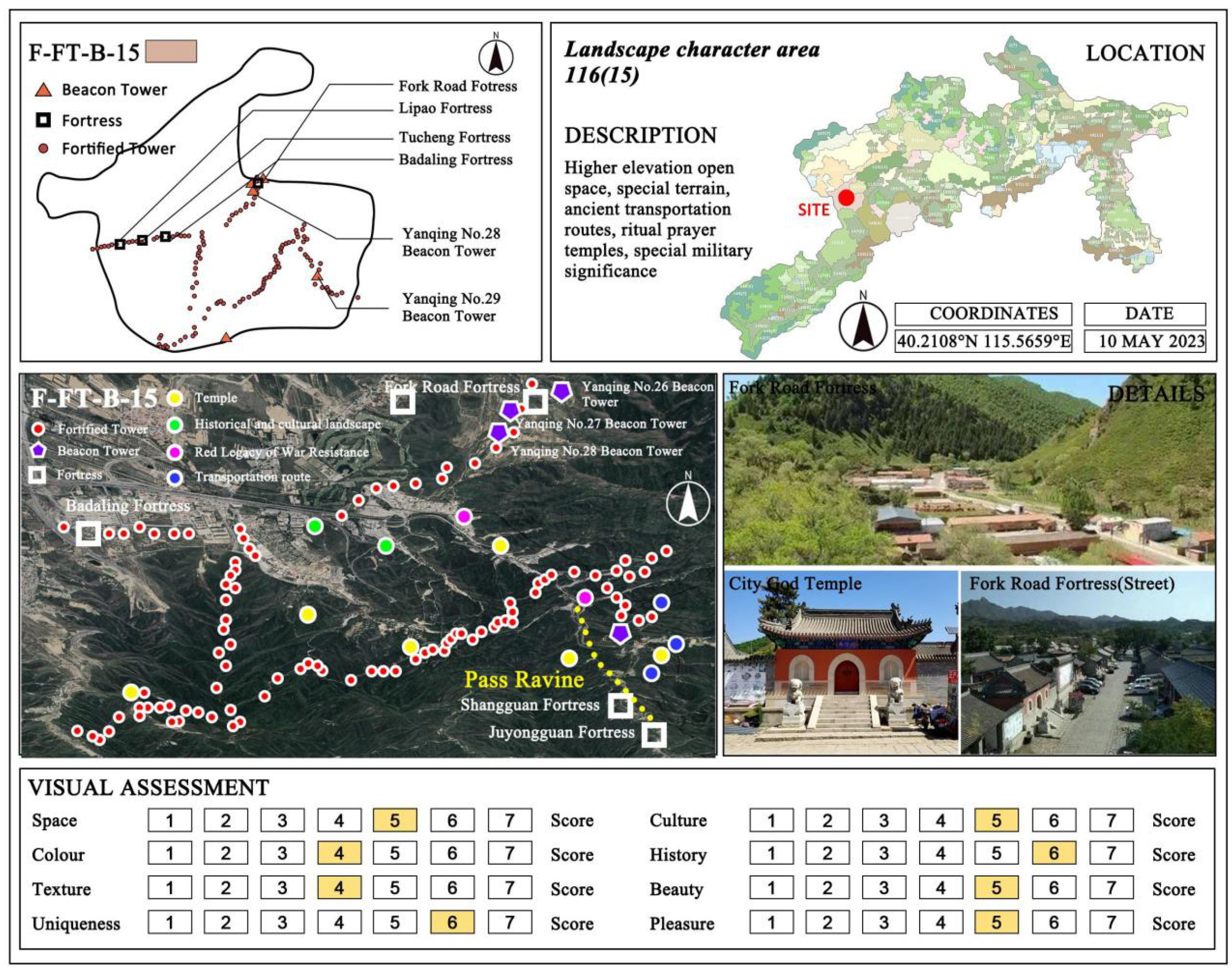
| 15 | The whole patch is located in the northern part of the Badaling Great Wall section in an open area with higher elevation, surrounded by construction land and grassland. There are four fortresses, namely, the Lipao Ancient Fortress, the Tucheng Ancient Fortress, the Badaling Fortress, and the Fork Road Ancient Fortress. The Fork Road Fortress has been a transportation fortress since ancient times and is surrounded by mountains, which are full of red leaves in the fall. This area comprises an historical military cultural zone of the Great Wall and the cultural exchange zone of the northwest seaside, with the Guandi Temple, the Chenghuang Temple, mosque ruins, government offices, mansions, theaters, other architectural remains, and 300-year-old acacia trees, as well as a military drill ground, an ammunition warehouses, and other cultural heritage sites. |
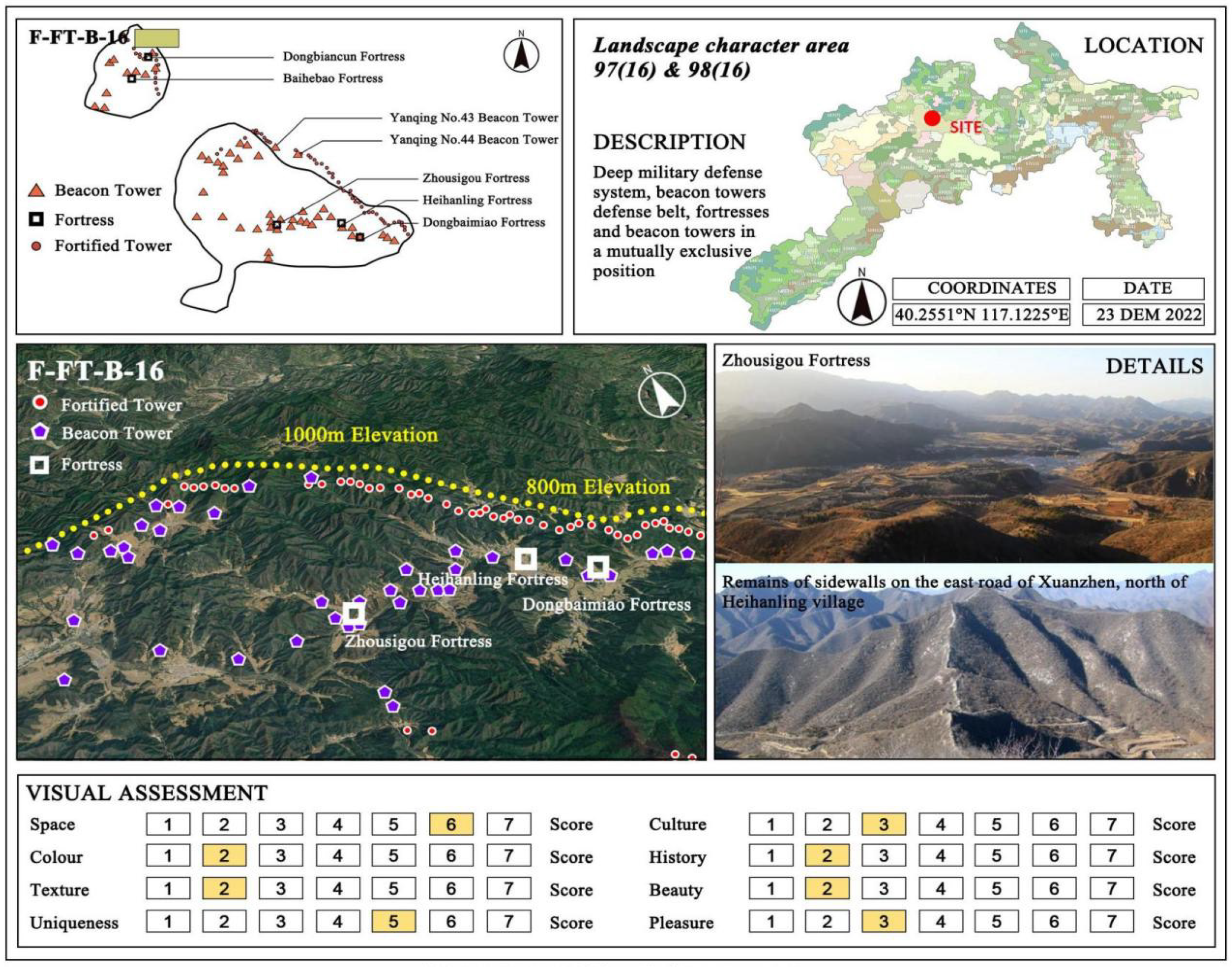
| 16 | Located in a steep mountainous area with an average elevation of about 700 m, the surrounding land is rich in grasslands, artificial evergreen coniferous forests, and construction land. The northwestern part of this patch is a belt of nearly dozens of beacon towers connected in the Yanqing district, and the wall and the belt of the beacon towers historically formed a deep defense system with the fortresses and the fortified towers. |
| 17 | Located in hilly areas of river valleys, the surrounding land is dominated by built-up land and grassland, and the soil is predominantly moist. The fortresses in the patch, such as the Xiangying Fortress and the Ma Ying Fortress, are all abandoned and used for other purposes. There are other patches that are currently used more as wetland parks for public recreation, such as the Mallard Lake Wetland Park and the Sanlihe Wetland Park. |
| 18 | Located in the plain area, it is surrounded by construction land. The northwestern part of this patch is the location of Ming Dynasty fortresses such as Shuangying, Miliangtun, Dongbaimiao Fortress, etc. The fortresses had various functions, not only as barracks but also for postal communications, forming a network system, which is now mostly abandoned. The southeastern part of this patch comprises Xiong’erzhai, Yuzishan, the Beizhai Village, Emeishanying, Heishuiwan, and other Ming Dynasty fortresses, now developed into fortress-city-type villages, adapted from military to civilian use. These fortress cities attach importance to the construction of temples, so the Guandi Temple, the City God Temple, the Niangniang Temple, and other temple buildings can be found here. |
| 19 | The area is mostly located on a riverbank, and the geographical environment, with suitable cultivated land and water sources, was suitable for the construction of fortresses. The largest patch is located around the Miyun Reservoir, with Maying Fortress and Shitanglu Fortress to the west. With the expansion of the reservoir area, Maying Fortress has now sunk to the bottom of the reservoir, and only Shitanglu Fortress still exists. |
| 20 | The central patch is the site of the present-day Miyun Reservoir in Beijing, which is the largest comprehensive water conservancy project in North China and is a water conservation area. The northwestern patch is the site of the present-day Guanting Reservoir in Beijing, surrounded by numerous tourist attractions. |
Appendix B


References
- Zhou, X.; Li, J.; Liu, Y. Landscape-Based Heritage Research and Practice. Landsc. Archit. Front. 2023, 11, 4. [Google Scholar] [CrossRef]
- Knitter, D.; Braun, R.; Clare, L.; Nykamp, M.; Schütt, B. Göbekli Tepe: A Brief Description of the Environmental Development in the Surroundings of the UNESCO World Heritage Site. Land 2019, 8, 72. [Google Scholar] [CrossRef]
- Perry, J.; Gordon, I.J. Adaptive Heritage: Is This Creative Thinking or Abandoning Our Values? Climate 2021, 9, 128. [Google Scholar] [CrossRef]
- He, D.; Hu, J.; Zhang, J. Assessment of Sustainable Development Suitability in Linear Cultural Heritage—A Case of Beijing Great Wall Cultural Belt. Land 2023, 12, 1761. [Google Scholar] [CrossRef]
- Li, L.; Feng, R.; Xi, J. Ecological Risk Assessment and Protection Zone Identification for Linear Cultural Heritage: A Case Study of the Ming Great Wall. Int. J. Environ. Res. Public Health 2021, 18, 11605. [Google Scholar] [CrossRef] [PubMed]
- Merciu, F.-C.; Păunescu, C.; Dorobanţu, M.; Merciu, G.-L. Assessing the Value of Railway Heritage for Sustainable Development: The Case Study of the Oraviţa–Anina Railway, Romania. Sustainability 2022, 14, 13262. [Google Scholar] [CrossRef]
- Yue, F.; Li, X.; Huang, Q.; Li, D. A Framework for the Construction of a Heritage Corridor System: A Case Study of the Shu Road in China. Remote Sens. 2023, 15, 4650. [Google Scholar] [CrossRef]
- UNESCO. The Great Wall. 1987. Available online: https://whc.unesco.org/en/list/438/ (accessed on 11 December 2023).
- Xu, H.; Chen, F.; Zhou, W. A Comparative Case Study of MTInSAR Approaches for Deformation Monitoring of the Cultural Landscape of the Shanhaiguan Section of the Great Wall. Herit. Sci. 2021, 9, 71. [Google Scholar] [CrossRef]
- Zhang, R.; Wang, J.; Brown, S. ‘The Charm of a Thousand Years’: Exploring Tourists’ Perspectives of the ‘Culture-Nature Value’ of the Humble Administrator’s Garden, Suzhou, China. Landsc. Res. 2021, 46, 1071–1088. [Google Scholar] [CrossRef]
- Zhang, S.; Chen, W.; Guo, Z. Study on the Spatial Regularity of Rammed Pits of the Ming Great Wall Using 3D Scanning Technique and Random Forest Algorithm. J. Cult. Herit. 2023, 62, 230–241. [Google Scholar] [CrossRef]
- Mücher, C.A.; Klijn, J.A.; Wascher, D.M.; Schaminée, J.H.J. A New European Landscape Classification (LANMAP): A Transparent, Flexible and User-Oriented Methodology to Distinguish Landscapes. Ecol. Indic. 2010, 10, 87–103. [Google Scholar] [CrossRef]
- Romportl, D.; Chuman, T. Present Approaches to Landscape Typology in the Czech Republic. J. Landsc. Ecol. 2012, 5, 24–35. [Google Scholar] [CrossRef]
- Recommendation Concerning the Safeguarding and Contemporary Role of Historic Areas; Recommendation; UNESECO: Nairobi, Kenya, 1976; Available online: https://unesdoc.unesco.org/ark:/48223/pf0000114038.page=136 (accessed on 12 October 2023).
- Richards, J.; Orr, S.A.; Viles, H. Reconceptualising the Relationships between Heritage and Environment within an Earth System Science Framework. J. Cult. Heritage Manag. Sustain. Dev. 2019, 10, 122–129. [Google Scholar] [CrossRef]
- Eiter, S.; Fjellstad, W.; Puschmann, O.; Krøgli, S.O. Long-Term Monitoring of Protected Cultural Heritage Environments in Norway: Development of Methods and First-Time Application. Land 2019, 8, 75. [Google Scholar] [CrossRef]
- Yang, C.; Sim, J.; Lawson, G. Deciphering Historic Landscapes: A Case Study of Slender West Lake in Yangzhou, China. Landsc. Res. 2016, 41, 95–112. [Google Scholar] [CrossRef]
- Guo, J. Heritage Landscape Conservation and Development. In Digital Heritage. Progress in Cultural Heritage: Documentation, Preservation, and Protection; Ioannides, M., Magnenat-Thalmann, N., Fink, E., Žarnić, R., Yen, A.-Y., Quak, E., Eds.; Lecture Notes in Computer Science; Springer International Publishing: Cham, Switzerland, 2014; Volume 8740, pp. 687–696. [Google Scholar] [CrossRef]
- Wu, Z.; Ma, J.; Zhang, H. Spatial Reconstruction and Cultural Practice of Linear Cultural Heritage: A Case Study of Meiguan Historical Trail, Guangdong, China. Buildings 2022, 13, 105. [Google Scholar] [CrossRef]
- Leong, C.; Takada, J.; Hanaoka, S.; Yamaguchi, S. Impact of Tourism Growth on the Changing Landscape of a World Heritage Site: Case of Luang Prabang, Lao PDR. Sustainability 2017, 9, 1996. [Google Scholar] [CrossRef]
- Agapiou, A.; Lysandrou, V.; Alexakis, D.D.; Themistocleous, K.; Cuca, B.; Argyriou, A.; Sarris, A.; Hadjimitsis, D.G. Cultural Heritage Management and Monitoring Using Remote Sensing Data and GIS: The Case Study of Paphos Area, Cyprus. Comput. Environ. Urban Syst. 2015, 54, 230–239. [Google Scholar] [CrossRef]
- Zhang, X.; Zhou, L.; Wu, Y.; Skitmore, M.; Deng, Z. Resolving the Conflicts of Sustainable World Heritage Landscapes in Cities: Fully Open or Limited Access for Visitors? Habitat Int. 2015, 46, 91–100. [Google Scholar] [CrossRef]
- Bray, P.M. The Heritage Area Phenomenon Where It Is Coming From? Cult. Resour. Manag. Inf. 1994, 17, 3–4. [Google Scholar]
- Laven, D.N.; Jewiss, J.L.; Mitchell, N.J. Toward Landscape-Scale Stewardship and Development: A Theoretical Framework of United States National Heritage Areas. Soc. Nat. Resour. 2013, 26, 762–777. [Google Scholar] [CrossRef]
- Gong, D.D. The Origin and Characteristics of the Concept of National Cultural Park. Chin. Landsc. Archit. 2021, 37, 38–42. [Google Scholar] [CrossRef]
- Jouan, P.; Hallot, P. Digital Twin: Research Framework to Support Preventive Conservation Policies. ISPRS Int. J. Geo-Inf. 2020, 9, 228. [Google Scholar] [CrossRef]
- Harvey, D. Landscape and Heritage: Trajectories and Consequences. Landsc. Res. 2015, 40, 911–924. [Google Scholar] [CrossRef]
- D’Ascanio, R.; Barbieri, L.; De Pasquale, G.; Filpa, A.; Palazzo, A.L. Landscape Works. Balancing Nature and Culture in the Pantelleria National Park. Sustainability 2021, 13, 13371. [Google Scholar] [CrossRef]
- Pilquiman Vera, M.J.; Merino Espeso, A.; Cabrera Campos, G. Paisaje Patrimonial y Turismo En La Zona Precordillerana de Panguipulli, Sur de Chile. Investig. Tur. 2020, 20, 262. [Google Scholar] [CrossRef]
- Yu, H.; Verburg, P.H.; Liu, L.; Eitelberg, D.A. Spatial Analysis of Cultural Heritage Landscapes in Rural China: Land Use Change and Its Risks for Conservation. Environ. Manag. 2016, 57, 1304–1318. [Google Scholar] [CrossRef] [PubMed]
- ICOMOS. Yatra Aur Tammanah Yatra: Our Purposeful Journey and Tammanah: Our Wishful Aspirations for Our Heritage; ICOMOS: Paris, France; Available online: https://www.icomos.org/images/DOCUMENTS/General_Assemblies/19th_Delhi_2017/19th_GA_Outcomes/ICOMOS_GA2017_CNJ_YatraStatement_final_EN_20180207circ.pdf (accessed on 20 January 2023).
- IUCN. Connecting Practice: Defining New Methods and Strategies to Support Nature and Culture through Engagement in the World Heritage Convention; IUCN: Gland, Switzerland; Available online: https://www.iucn.org/our-work/protected-areas-and-land-use (accessed on 20 January 2023).
- ICOMOS. Connecting Practice: A Commentary on Nature-Culture Keywords, 1st ed.; ICOMOS International Secretariat: Paris, France, 2021. [Google Scholar]
- Li, W.; Yang, R.; Yan, L.; Xie, Y.; Liu, H.; Chen, F. Risk Assessment of City Site Landscapes in the Central Plains of China. Herit. Sci. 2023, 11, 14. [Google Scholar] [CrossRef]
- Cai, Z.; Li, J.; Wang, J. The Protection and Landscape Characteristics of Traditional Villages in Coastal Areas of SW China. J. Coast. Res. 2020, 111, 331–335. [Google Scholar] [CrossRef]
- Li, G.; Hu, W. A Network-Based Approach for Landscape Integration of Traditional Settlements: A Case Study in the Wuling Mountain Area, Southwestern China. Land Use Policy 2019, 83, 105–112. [Google Scholar] [CrossRef]
- Brown, M.; Murtha, T. Integrating Natural and Cultural Resources in North American Large-Landscape Conservation. Environ. Pract. 2019, 21, 57–68. [Google Scholar] [CrossRef]
- Swanwick, C. Landscape Character Assessment: Guidance for England and Scotland; The Countryside Agency: Cheltenham, UK, 2002. [Google Scholar]
- Butler, A.; Åkerskog, A. Awareness-Raising of Landscape in Practice. An Analysis of Landscape Character Assessments in England. Land Use Policy 2014, 36, 441–449. [Google Scholar] [CrossRef]
- Fairclough, G.; Herlin, I.S.; Swanwick, C. (Eds.) Routledge Handbook of Landscape Character Assessment: Current Approaches to Characterisation and Assessment, 1st ed.; Routledge: Abingdon, UK; New York, NY, USA, 2018. [Google Scholar] [CrossRef]
- Terkenli, T.; Gkoltsiou, A.; Kavroudakis, D. The Interplay of Objectivity and Subjectivity in Landscape Character Assessment: Qualitative and Quantitative Approaches and Challenges. Land 2021, 10, 53. [Google Scholar] [CrossRef]
- Zhuang, Q.D.; Hussein, M.K.; Ariffin, N.F.M.; Yunos, M.Y.M. Landscape Character: A Knowledge Mapping Analysis Using CiteSpace. Int. J. Environ. Sci. Technol. 2022, 19, 10477–10492. [Google Scholar] [CrossRef]
- Brown, G.; Brabyn, L. The Extrapolation of Social Landscape Values to a National Level in New Zealand Using Landscape Character Classification. Appl. Geogr. 2012, 35, 84–94. [Google Scholar] [CrossRef]
- Carlier, J.; Doyle, M.; Finn, J.A.; Ó hUallacháin, D.; Moran, J. A Landscape Classification Map of Ireland and Its Potential Use in National Land Use Monitoring. J. Environ. Manag. 2021, 289, 112498. [Google Scholar] [CrossRef]
- Pihler, V.; Vasiljević, N.; Đorđević, D.; Bajić, L.; Dunčić, D. New Landscape Conceptualization as a Guideline for Spatial Development: A Case Study from Serbian Spatial Planning Practice. Geogr. Pannonica 2021, 25, 204–213. [Google Scholar] [CrossRef]
- Guneroglu, N.; Acar, C.; Guneroglu, A.; Dihkan, M.; Karsli, F. Coastal Land Degradation and Character Assessment of Southern Black Sea Landscape. Ocean Coast. Manag. 2015, 118, 282–289. [Google Scholar] [CrossRef]
- Atik, M.; Işikli, R.C.; Ortaçeşme, V.; Yildirim, E. Definition of Landscape Character Areas and Types in Side Region, Antalya-Turkey with Regard to Land Use Planning. Land Use Policy 2015, 44, 90–100. [Google Scholar] [CrossRef]
- Gkoltsiou, A.; Paraskevopoulou, A. Landscape Character Assessment, Perception Surveys of Stakeholders and SWOT Analysis: A Holistic Approach to Historical Public Park Management. J. Outdoor Recreat. Tour. 2021, 35, 100418. [Google Scholar] [CrossRef]
- Martín, B.; Ortega, E.; Otero, I.; Arce, R.M. Landscape Character Assessment with GIS Using Map-Based Indicators and Photographs in the Relationship between Landscape and Roads. J. Environ. Manag. 2016, 180, 324–334. [Google Scholar] [CrossRef]
- Wu, Y.; Wang, H.; Zhang, B. Landscape Character Diversity and Zoning Management: Case of Wuhan Metropolitan Area. J. Urban Plann. Dev. 2021, 147, 04020062. [Google Scholar] [CrossRef]
- Mou, J.; Chen, Z.; Huang, J. Predicting Urban Expansion to Assess the Change of Landscape Character Types and Its Driving Factors in the Mountain City. Land 2023, 12, 928. [Google Scholar] [CrossRef]
- Pan, Y.; Wu, Y.; Xu, X.; Zhang, B.; Li, W. Identifying Terrestrial Landscape Character Types in China. Land 2022, 11, 1014. [Google Scholar] [CrossRef]
- Wang, Y.; Du, J.; Kuang, J.; Chen, C.; Li, M.; Wang, J. Two-Scaled Identification of Landscape Character Types and Areas: A Case Study of the Yunnan–Vietnam Railway (Yunnan Section), China. Sustainability 2023, 15, 6173. [Google Scholar] [CrossRef]
- Brabyn, L. Classifying Landscape Character. Landsc. Res. 2009, 34, 299–321. [Google Scholar] [CrossRef]
- Simensen, T.; Halvorsen, R.; Erikstad, L. Methods for Landscape Characterisation and Mapping: A Systematic Review. Land Use Policy 2018, 75, 557–569. [Google Scholar] [CrossRef]
- Li, G.; Zhang, B. Identification of Landscape Character Types for Trans-Regional Integration in the Wuling Mountain Multi-Ethnic Area of Southwest China. Landsc. Urban Plan. 2017, 162, 25–35. [Google Scholar] [CrossRef]
- Yang, D.; Gao, C.; Li, L.; Van Eetvelde, V. Multi-Scaled Identification of Landscape Character Types and Areas in Lushan National Park and Its Fringes, China. Landsc. Urban Plan. 2020, 201, 103844. [Google Scholar] [CrossRef]
- Lu, Y.; Xu, S.; Liu, S.; Wu, J. An Approach to Urban Landscape Character Assessment: Linking Urban Big Data and Machine Learning. Sustain. Cities Soc. 2022, 83, 103983. [Google Scholar] [CrossRef]
- Council of Europe. European Landscape Convention; Council of Europe: Strasbourg, France, 2000; Available online: http://www.coe.int/en/web/conventions/full-list/-/conventions/treaty/176 (accessed on 23 October 2023).
- Vlami, V.; Kokkoris, I.P.; Zogaris, S.; Cartalis, C.; Kehayias, G.; Dimopoulos, P. Cultural Landscapes and Attributes of “Culturalness” in Protected Areas: An Exploratory Assessment in Greece. Sci. Total Environ. 2017, 595, 229–243. [Google Scholar] [CrossRef] [PubMed]
- Abdelrahman, A.; Alghamdi, M. Evaluating Cultural Heritage Landscape Design as an Approach for Al Bujairi Park Development, Saudi Arabia; WIT Press: Lisbon, Portugal, 2022; pp. 73–85. [Google Scholar] [CrossRef]
- Kirchner, K.; Kuda, F.; Kubalíková, L.; Machar, I.; Pechanec, V. Cultural Heritage and Geodiversity of Landforms in the Landscape of the Archdiocese of Olomouc; Masarykova Univerzita Nakladatelství: Brno, Czech Republic, 2018; pp. 165–172. [Google Scholar]
- Bandarin, F.; van Oers, R. The Historic Urban Landscape: Managing Heritage in an Urban Century; Wiley Blackwell: Chichester, UK, 2014. [Google Scholar]
- Taylor, K. The Historic Urban Landscape Paradigm and Cities as Cultural Landscapes. Challenging Orthodoxy in Urban Conservation. Landsc. Res. 2016, 41, 471–480. [Google Scholar] [CrossRef]
- UNESCO. Recommendation on the Historic Urban Landscape; UNESCO: Paris, France, 2011; Available online: https://whc.unesco.org/uploads/activities/documents/activity-638-98.pdf (accessed on 15 July 2023).
- Cunha Ferreira, T.; Rey-Pérez, J.; Pereira Roders, A.; Tarrafa Silva, A.; Coimbra, I.; Breda Vazquez, I. The Historic Urban Landscape Approach and the Governance of World Heritage in Urban Contexts: Reflections from Three European Cities. Land 2023, 12, 1020. [Google Scholar] [CrossRef]
- Hussein, F.; Stephens, J.; Tiwari, R. Cultural Memories and Sense of Place in Historic Urban Landscapes: The Case of Masrah Al Salam, the Demolished Theatre Context in Alexandria, Egypt. Land 2020, 9, 264. [Google Scholar] [CrossRef]
- Zetter, R.; Watson, G.B. Designing Sustainable Cities in the Developing World; Routledge: London, UK, 2016. [Google Scholar]
- Fagerholm, N.; Käyhkö, N.; Van Eetvelde, V. Landscape Characterization Integrating Expert and Local Spatial Knowledge of Land and Forest Resources. Environ. Manag. 2013, 52, 660–682. [Google Scholar] [CrossRef] [PubMed]
- Chen, T.B.; Wang, L.F.; Ren, J. Study on the Cultural Heritage Value of the Great Wall. China Cult. Herit. 2018, 3, 4–14. [Google Scholar]
- Zhang, Y.K.; Li, Y. Illustration on the Defense System Distribution of the Nine Important Defense Areas in the Great Wall of Ming Dynasty. Huazhong Archit. 2005, 2, 116–119+153. [Google Scholar]
- Li, H.B.; Ma, B.C. (Eds.) The Great Wall of China; Environment-Economy-Ethnicity; Jiangsu Phoenix Science and Technology Press: Nanjing, China, 2016. [Google Scholar]
- Hu, P.P.; Tang, Y. Research on the Historic Feature and Protection Project of Natural Environment for the Great Wall. J. Beijing Univ. Civ. Eng. Archit. 2007, 3, 40–44. [Google Scholar]
- Hu, P.P. Study on the Relationship between Physical Geography and the Beijing Section of the Great Wall; Beijing University of Civil Engineering and Architecture: Beijing, China, 2007. [Google Scholar]
- He, D.; Wang, Z.Y.; Zhang, J.; Zhang, J.; Yang, Z.; Sun, Z. Spatial distribution characteristics of the Ming Great Wall heritages in Beijing. J. Arid. Land Resour. Environ. 2022, 36, 184–191. [Google Scholar]
- The Great Wall Conservation Master Plan; Ministry of Culture and Tourism, State Administration of Cultural Heritage: Beijing, China, 2019. Available online: https://www.gov.cn/zhengce/zhengceku/2019-12/09/5459721/files/683a92ff615c44788c5ccc378931d2c9.pdf (accessed on 25 September 2023).
- ICOFORT. ICOMOS Guidelines on Fortifications and Military Heritage; ICOFORT: Juazeiro, Brazil, 2021; Available online: https://www.icomos.org/images/DOCUMENTS/General_Assemblies/GA_2021/AGA_202111_6-1_ICOMOS_Guidelines_Fortifications_MilitaryHeritage_2021_EN.pdf (accessed on 18 September 2023).
- Tang, Y.Y.; Liu, Z.Y. Reflections on the Preparation of the Protection Plan for the Great Wall of Beijing. China Cult. Herit. 2018, 41–47. [Google Scholar]
- Plan for the Protection and Development of the Beijing Great Wall Cultural Belt (2018–2035); Beijing Municipal Bureau of Cultural Heritage: Beijing, China, 2019.
- Zhao, S.; Yang, D.; Gao, C. Identifying Landscape Character for Large Linear Heritage: A Case Study of the Ming Great Wall in Ji-Town, China. Sustainability 2023, 15, 2615. [Google Scholar] [CrossRef]
- Atik, M.; Işıklı, R.C.; Ortaçeşme, V.; Yıldırım, E. Exploring a Combination of Objective and Subjective Assessment in Landscape Classification: Side Case from Turkey. Appl. Geogr. 2017, 83, 130–140. [Google Scholar] [CrossRef]
- Carlier, J.; Moran, J. Landscape Typology and Ecological Connectivity Assessment to Inform Greenway Design. Sci. Total Environ. 2019, 651, 3241–3252. [Google Scholar] [CrossRef]
- Fňukalová, E.; Romportl, D. A Typology of Natural Landscapes of Central Europe. AUC Geogr. 2014, 49, 57–63. [Google Scholar] [CrossRef][Green Version]
- Soto, S.; Pintó, J. Delineation of Natural Landscape Units for Puerto Rico. Appl. Geogr. 2010, 30, 720–730. [Google Scholar] [CrossRef]
- Chiu, T.; Fang, D.; Chen, J.; Wang, Y.; Jeris, C. A Robust and Scalable Clustering Algorithm for Mixed Type Attributes in Large Database Environment. In Proceedings of the Seventh ACM SIGKDD International Conference on Knowledge Discovery and Data Mining, San Francisco, CA, USA, 26–29 August 2001; ACM: San Francisco, CA, USA, 2001; pp. 263–268. [Google Scholar] [CrossRef]
- Skånes, H.M.; Bunce, R.G.H. Directions of Landscape Change (1741–1993) in Virestad, Sweden—Characterised by Multivariate Analysis. Landsc. Urban Plan. 1997, 38, 61–75. [Google Scholar] [CrossRef]
- Bacher, J.; Wenzig, K.; Vogler, M. SPSS Two-Step Cluster: A First Evaluation; Friedrich-Alexander-Universität Erlangen-Nürnberg, Lehrstuhl für Soziologie: Amsterdam, The Netherlands, 2004. [Google Scholar]
- Chuman, T.; Romportl, D. Multivariate Classification Analysis of Cultural Landscapes: An Example from the Czech Republic. Landsc. Urban Plan. 2010, 98, 200–209. [Google Scholar] [CrossRef]
- Flanders, D.; Hall-Beyer, M.; Pereverzoff, J. Preliminary Evaluation of eCognition Object-Based Software for Cut Block Delineation and Feature Extraction. Can. J. Remote Sens. 2003, 29, 441–452. [Google Scholar] [CrossRef]
- Petrova, P.; Hristov, D. Collaborative Management and Planning of Urban Heritage Tourism: Public Sector Perspective. J. Tour. Res. 2016, 18, 1–9. [Google Scholar] [CrossRef]
- Su, M.M.; Wall, G. Global–Local Relationships and Governance Issues at the Great Wall World Heritage Site, China. J. Sustain. Tour. 2012, 20, 1067–1086. [Google Scholar] [CrossRef]
- Preece, P.B.E.J. Exmoor Landscape Character Assessment Report; Exmoor National Park Authority: Somerset, UK, 2007.
- Wood, R.; Handley, J. Landscape Dynamics and the Management of Change. Landsc. Res. 2001, 26, 45–54. [Google Scholar] [CrossRef]
- UNESCO WHC. Operational Guidelines for the Implementation of the World Heritage Convention; UNESCO World Heritage Center: Paris, France, 2021; Available online: https://whc.unesco.org/en/guidelines/ (accessed on 20 May 2023).
- Douglass, K.; Morales, E.Q.; Manahira, G.; Fenomanana, F.; Samba, R.; Lahiniriko, F.; Chrisostome, Z.M.; Vavisoa, V.; Soafiavy, P.; Justome, R.; et al. Toward a Just and Inclusive Environmental Archaeology of Southwest Madagascar. J. Soc. Archaeol. 2019, 19, 307–332. [Google Scholar] [CrossRef]


| Variables | Code | Variables | Code |
|---|---|---|---|
| Land cover | L | Relief Amplitude (m) | R |
| Rainfed cropland | L1 | <20 | R1 |
| Herbaceous cover | L2 | 20–50 | R2 |
| Irrigated cropland | L3 | 50–80 | R3 |
| Open deciduous broad-leaved forest (0.15 < fc < 0.4) | L4 | 80–110 | R4 |
| Closed deciduous broad-leaved forest (fc > 0.4) | L5 | >110 | R5 |
| Open evergreen needle-leaved forest (0.15 < fc < 0.4) | L6 | Slope (°) | SL |
| Closed evergreen needle-leaved forest (fc > 0.4) | L7 | 0–7 | SL1 |
| Open deciduous needle-leaved forest (0.15 < fc < 0.4) | L8 | 7–15 | SL2 |
| Closed deciduous needle-leaved forest (fc > 0.4) | L9 | 15–20 | SL3 |
| shrubland | L10 | 20–30 | SL4 |
| Grassland | L11 | 30–40 | SL5 |
| Sparse vegetation (f < 0.15) | L12 | 40–80 | SL6 |
| Wetlands | L13 | Soil | S |
| Impervious surfaces | L14 | Brown soil | S1 |
| Bare areas | L15 | Cinnamon soil | S2 |
| Water body | L16 | Aeolian soil | S3 |
| Elevation (m) | E | Litho soil | S4 |
| <200 | E1 | Skeletal soil | S5 |
| 200–400 | E2 | Lime concretion black soil | S6 |
| 400–600 | E3 | ||
| 600–800 | E4 | Mountain meadow soil | S7 |
| 800–1000 | E5 | Fluvo-aquic soil | S8 |
| 1000–2200 | E6 | Reservoir | S9 |
| Variables | Code |
|---|---|
| Great Wall Heritage Registration Form for Immovable Cultural Relics of the Third National Cultural Relics Census | |
| Fortified Tower | FT |
| Beacon Tower | B |
| Fortress | F |
| Cultural Resources Related to the Great Wall Beijing Great Wall Cultural Belt Protection and Development Plan (2018–2035) | |
| Red Legacy of War Resistance | R |
| Historical and Cultural Landscape | H |
| Mausoleum | M |
| Temples | T |
| Transportation Route | TR |
| Military Defense Village | MD |
| Category | Cluster | Dominated Land Cover | Average Elevation | Average Amplitude | Average Slope | Dominated Soil | Percentage | |
|---|---|---|---|---|---|---|---|---|
| F-FT-B Fortress, Fortified Tower, and Beacon Tower | 14 | L11 | 479 m | 76.81 m | 14.64° | S2, S1, S5 | 14.09% | 45.83% |
| 12 | L11, L7, L9, L14, L13 | 604 m | 99.78 m | 17.67° | S2 | 11.51% | ||
| 16 | L11, L7, L14 | 695 m | 60.92 m | 12.43° | S2 | 6.35% | ||
| 15 | L11, L14, L15 | 634 m | 46.10 m | 8.25° | S2 | 2.58% | ||
| 13 | L11, L14, L15 | 389 m | 47.30 m | 9.15° | S2 | 11.31% | ||
| F-FT Fortress and Fortified Tower | 2 | L11 | 734 m | 118.96 m | 20.91° | S2 | 12.70% | 23.81% |
| 18 | L14 | 476 m | 50.78 m | 7.22° | S2 | 11.11% | ||
| F Fortress | 17 | L14, L11, L16 | 393 m | 13.66 m | 3.35° | S8, S9 | 6.75% | 17.06% |
| 4 | L11, L14, L7 | 460 m | 83.24 m | 15.00° | S2 | 4.17% | ||
| 19 | L16, L15, L12 | 308 m | 28.63 m | 6.88° | S2 | 6.15% | ||
| FT Fortified Tower | 9 | L7 | 720 m | 94.58 m | 18.38° | S2 | 7.94% | 13.29% |
| 3 | L9, L5, L13, L12 | 630 m | 86.58 m | 16.24° | S2 | 5.36% | ||
| Category | Cluster | Pattern Category | Typical Pattern Combinations 1 | Specific Characteristics | Occurrence of Landscape Character Type Related to Geographic Location | Typical Case |
|---|---|---|---|---|---|---|
| F-FT-B | 12 | Random |  | F, FT, and B evenly and densely distributed; mountainous; woodland–grassland | Most treacherous section of the Arrowbolt Great Wall in the central and northeastern mountainous areas |  |
| 14 | Random |  | F, FT, and B evenly and densely distributed; hilly; grassland | Distributed along the Great Wall, complementary to Types 12 and 13, in low/middle mountainous areas |  | |
| 13 | Random |  | F and FT-B clusters are farther apart, and the distribution is related to the relief and land use; hilly; grassland–building land | Distributed along the Great Wall, complementary to Type 12, in low/middle mountainous areas |  | |
| 15 | Regular |  | FT distributed near ravines and F in open plateaus; mountainous; grassland–building land | Higher-elevation open areas in the northern part of the Badaling Great Wall section |  | |
| 16 | Regular |  | Dozens of B are clustered around the F-FT to form a defensive belt; mountainous; woodland–grassland | Beacon belt between the East Road Border Wall and the Nanshan Road Border Wall in the northwestern Yanqing district |  | |
| F-FT | 2 | Random |  | Dominated by FT, the other elements are farther apart from each other; mountainous; grassland | Southwestern, southeastern, and northern areas, such as the Changyu Fortress area in the southwestern corner |  |
| 18 | Random |  | Dominated by F elements, with close proximity between the elements; hilly; building land | Northwestern and southeastern plains region |  | |
| F | 4 | Regular |  | Combat F located in areas of high relief and low elevation; hilly; grassland–building land | “Juyongguan Gully” in the southwestern part |  |
| 17 | Random |  | Cantonment F located at lower elevations in relatively flat and open areas; grassland–building | Western part |  | |
| 19 | Regular |  | Garrison F located around rivers with cropland and water sources; river | Around Miyun Reservoir |  | |
| 3 | Random |  | Appears as scattered patches; rich land use; middle mountainous areas | Scattered within the study area |  | |
| 9 | Regular |  | Dense and evenly distributed elements; single land use (woodland); high mountainous areas | Scattered in steep mountainous areas above 750 m |  |
 stands for beacon tower heritage elements. The number of curves is related to the elevation, and the higher the number, the higher the elevation. The curvature of the curves is related to the degree of relief, and the higher the curve, the higher of relief.
  stands for the land use of a woodland–grassland combination,
  stands for the land use of a grassland–building land combination, and a blank background means the distribution of a single land type.
Disclaimer/Publisher’s Note: The statements, opinions and data contained in all publications are solely those of the individual author(s) and contributor(s) and not of MDPI and/or the editor(s). MDPI and/or the editor(s) disclaim responsibility for any injury to people or property resulting from any ideas, methods, instructions or products referred to in the content. |
© 2024 by the authors. Licensee MDPI, Basel, Switzerland. This article is an open access article distributed under the terms and conditions of the Creative Commons Attribution (CC BY) license (https://creativecommons.org/licenses/by/4.0/).
Share and Cite
He, D.; Chen, W.; Zhang, J. Integrating Heritage and Environment: Characterization of Cultural Landscape in Beijing Great Wall Heritage Area. Land 2024, 13, 536. https://doi.org/10.3390/land13040536
He D, Chen W, Zhang J. Integrating Heritage and Environment: Characterization of Cultural Landscape in Beijing Great Wall Heritage Area. Land. 2024; 13(4):536. https://doi.org/10.3390/land13040536
Chicago/Turabian StyleHe, Ding, Wenting Chen, and Jie Zhang. 2024. "Integrating Heritage and Environment: Characterization of Cultural Landscape in Beijing Great Wall Heritage Area" Land 13, no. 4: 536. https://doi.org/10.3390/land13040536
APA StyleHe, D., Chen, W., & Zhang, J. (2024). Integrating Heritage and Environment: Characterization of Cultural Landscape in Beijing Great Wall Heritage Area. Land, 13(4), 536. https://doi.org/10.3390/land13040536