


Discussion on the Optimization Method of Public Service Facility Layout from the Perspective of Spatial Equity: A Study Based on the Central City of Shanghai


Abstract
:1. Introduction
2. Materials and Methods
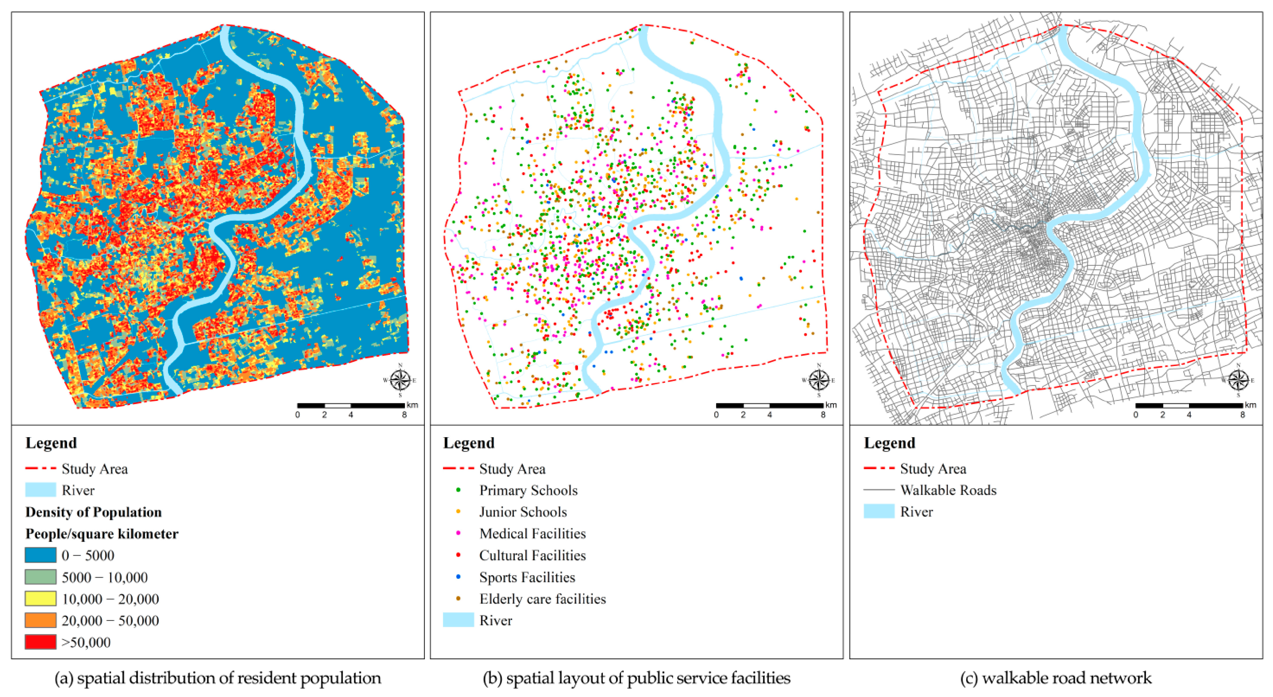
2.1. Materials
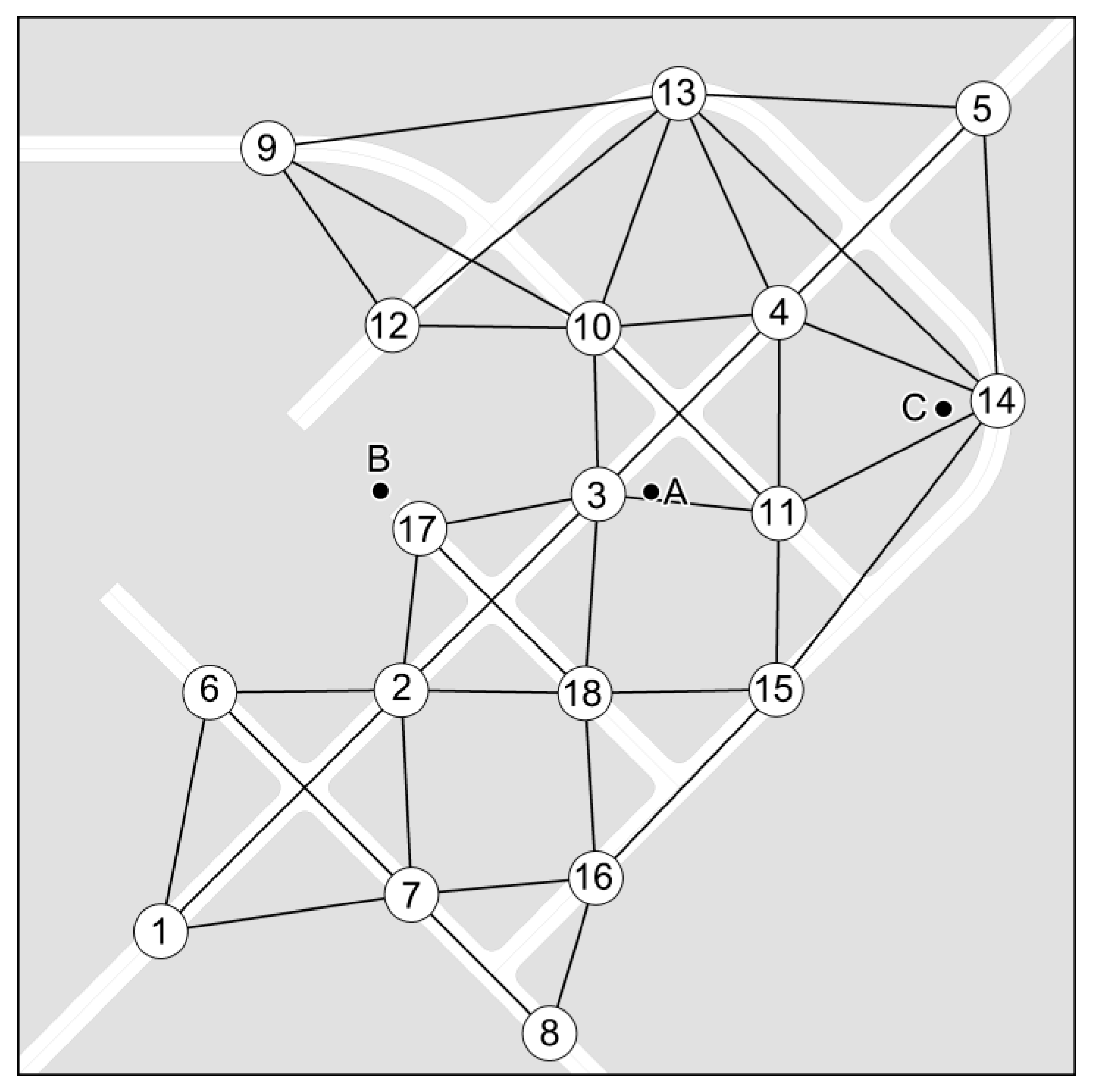
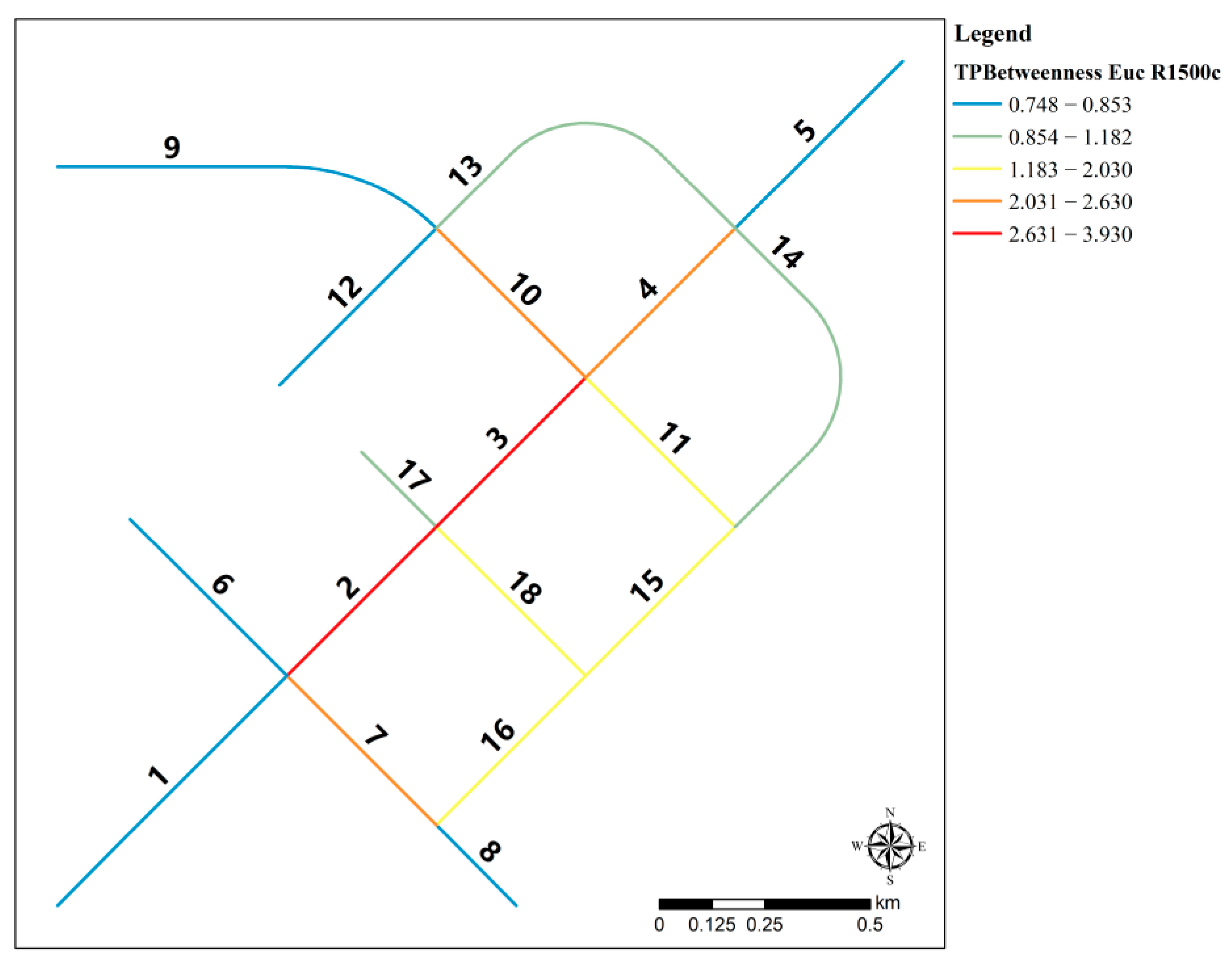
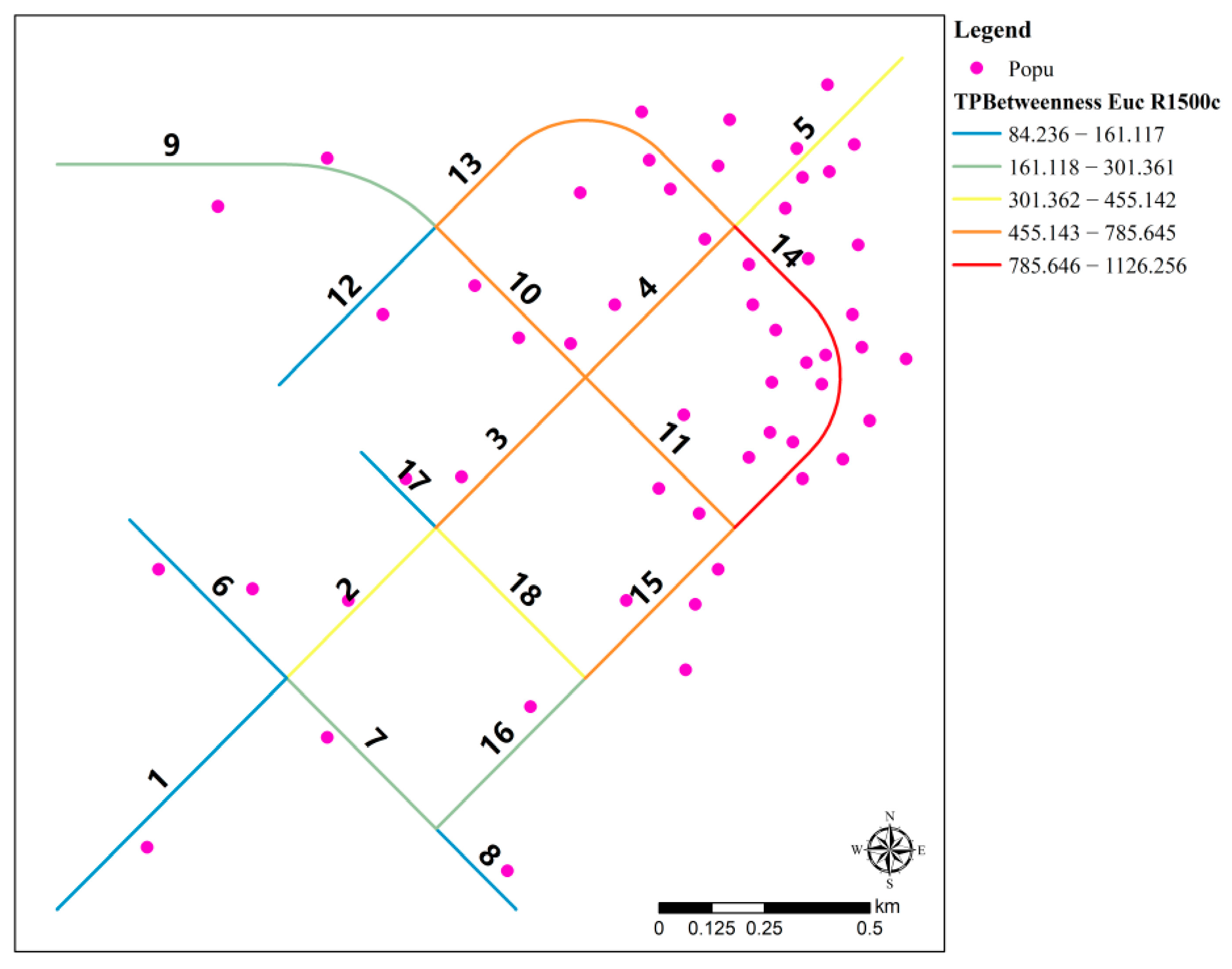
2.2. Methods
3. Results
3.1. Analysis of Public Service Demand
3.2. Analysis of Public Service Facilities Supply
3.3. Spatial Equity Based on the Relationship of Supply and Demand
4. Discussion
4.1. Enhancing Equity via Optimizing the Layout of Public Service Facilities
4.2. Enhancing Equity via Optimizing Residential Spatial Patterns
4.3. Enhancing Equity via Optimizing Pedestrian Transportation Networks
5. Conclusions
Funding
Data Availability Statement
Conflicts of Interest
References
- Rawls, J. A Theory of Justice; The Belknap Press of Harvard University Press: Cambridge, MA, USA, 1971. [Google Scholar]
- Jiang, H.; Zhou, C.; Gao, J. Advance in the Equity of Spatial Distribution of Urban Public Service in Western Countries. City Plan. Rev. 2011, 35, 72–77. [Google Scholar]
- Li, A.; Zhang, J. Equal Urban Rural Public Service Facility Development. Planners 2011, 27, 5–11. [Google Scholar]
- Lucy, W. Equity and Planning for Local Services. J. Am. Plan. Assoc. 1981, 47, 447–457. [Google Scholar] [CrossRef]
- Hay, A.M. Concepts of Equity, Fairness and Justice in Geographical Studies. Trans. Inst. Br. Geogr. 1995, 20, 500–508. [Google Scholar] [CrossRef]
- Yhee, H.; Kim, S.; Kang, S. GIS-Based Evaluation Method for Accessibility of Social Infrastructure Facilities. Appl. Sci. 2021, 11, 5581. [Google Scholar] [CrossRef]
- Heynen, N.; Perkins, H.A.; Roy, P. The Political Ecology of Uneven Urban Green Space. Urban Aff. Rev. 2006, 42, 3–25. [Google Scholar] [CrossRef]
- Perkins, H.A.; Heynen, N.; Wilson, J. Inequitable access to urban reforestation: The impact of urban political economy on housing tenure and urban forests. Cities 2004, 21, 291–299. [Google Scholar] [CrossRef]
- Gao, J.; Zhou, C.; Ye, C. The Equitable Distribution of Public Services in Guangzhou. Planners 2010, 26, 12–18. [Google Scholar]
- Jiang, H.; Zhou, C.; Xiao, R. Spatial Differentiation and Social Equity of Public Parks in Guangzhou. City Plan. Rev. 2010, 4, 43–48. [Google Scholar]
- Zhang, Y.; Tarrant, M.A.; Green, G.T. The importance of differentiating urban and rural phenomena in examining the unequal distribution of locally desirable land. J. Environ. Manag. 2008, 88, 1314–1319. [Google Scholar] [CrossRef]
- Comber, A.; Brunsdon, C.; Green, E. Using a GIS-based network analysis to determine urban greenspace accessibility for different ethnic and religious groups. Landsc. Urban Plan. 2008, 86, 103–114. [Google Scholar] [CrossRef]
- Wicks, B.E.; Crompton, J.L. Citizen and Administrator Perspectives of Equity in the Delivery of Park Services. Leis. Sci. 1986, 8, 341–365. [Google Scholar] [CrossRef]
- Erkip, F. The distribution of urban public services: The case of parks and recreational services in Ankara. Cities 1997, 14, 353–361. [Google Scholar] [CrossRef]
- Wolch, J.; Wilson, J.P.; Fehrenbach, J. Parks and Park Funding in Los Angeles: An Equity-Mapping Analysis. Urban Geogr. 2005, 26, 4–35. [Google Scholar] [CrossRef]
- Wang, S.; Yung, E.; Hiu, K.; Yu, Y.; Tsou, J.Y. Right to the city and community facility planning for elderly: The case of urban renewal district in Hong Kong. Land Use Policy 2022, 114, 105978. [Google Scholar] [CrossRef]
- Weng, M.; Ding, N.; Li, J.; Jin, X.; Xiao, H.; He, Z.; Su, S. The 15-minute walkable neighborhoods: Measurement, social inequalities and implications for building healthy communities in urban China. J. Transp. Health 2019, 13, 259–273. [Google Scholar] [CrossRef]
- Caselli, B. From urban planning techniques to 15-minute neighbourhoods. A theoretical framework and GIS-based analysis of pedestrian accessibility to public services. Eur. Transp./Trasp. Eur. 2021, 85, 1–15. [Google Scholar] [CrossRef]
- Caselli, B.; Carra, M.; Rossetti, S.; Zazzi, M. Exploring the 15-minute neighbourhoods. An evaluation based on the walkability performance to public facilities. Transp. Res. Procedia 2022, 60, 346–353. [Google Scholar] [CrossRef]
- Song, G.; He, X.; Kong, Y.; Li, K.; Song, H.; Zhai, S.; Luo, J. Improving the Spatial Accessibility of Community-Level Healthcare Service toward the ‘15-Minute City’ Goal in China. ISPRS Int. J. Geo-Inf. 2022, 11, 436. [Google Scholar] [CrossRef]
- Lin, L.; Chen, T. The activity space and the 15-minute neighborhood: An empirical study using big data in Qingdao, China. J. Transp. Land Use 2023, 16, 1–17. [Google Scholar] [CrossRef]
- Zhang, S.; Zhen, F.; Kong, Y.; Lobsang, T.; Zou, S. Towards a 15-minute city: A network-based evaluation framework. Environ. Plan. B Urban Anal. City Sci. 2023, 50, 500–514. [Google Scholar] [CrossRef]
- Shanghai Municipal People’s Government. Shanghai Master Plan (2017–2035); Shanghai Scientific & Technical Publishers: Shanghai, China, 2018. [Google Scholar]
- Standard TD/T 1062-202; Spatial Planning Guidance to Community Life Unit. Ministry of Natural Resources of the People’s Republic of China: Beijing, China, 2021.
- Joel, E. GIS-based Network Analysis for Optimisation of Public Facilities Closure: A Study on Libraries in Leicestershire, United Kingdom. J. Geogr. Environ. Earth Sci. Int. 2019, 23, 1–18. [Google Scholar] [CrossRef]
- Hakimi, S.L. Optimum Locations of Switching Centers and the Absolute Centers and Medians of a Graph. Oper. Res. 1964, 12, 450–459. [Google Scholar] [CrossRef]
- Church, R.; ReVelle, C. The Maximal Covering Location Problem; Springer: Berlin/Heidelberg, Germany, 1974. [Google Scholar]
- ReVelle, C.; Toregas, C.; Falkson, L. Applications of the Location Set-covering Problem. Geogr. Anal. 1976, 8, 65–76. [Google Scholar] [CrossRef]
- Cornuéjols, G.; Nemhauser, G.; Wolsey, L. The Uncapacitated Facility Location Problem; School of Operations Research and Industrial Engineering, College of Engineering, Cornell University: Ithaca, NY, USA, 1983. [Google Scholar]
- Talen, E. Visualizing Fairness: Equity Maps for Planners. J. Am. Plan. Assoc. 1998, 64, 22–38. [Google Scholar] [CrossRef]
- Ribeiro, A.; Antunes, A.P. A GIS-based decision-support tool for public facility planning. Environ. Plan. B Plan. Des. 2002, 29, 553–569. [Google Scholar] [CrossRef]
- Talen, E.; Anselin, L. Assessing spatial equity: An evaluation of measures of accessibility to public playgrounds. Environ. Plan. A 1998, 30, 595–613. [Google Scholar] [CrossRef]
- Lindsey, G.; Maraj, M.; Kuan, S. Access, equity, and urban greenways: An exploratory investigation. Prof. Geogr. 2001, 53, 332–346. [Google Scholar] [CrossRef]
- Omer, I. Evaluating accessibility using house-level data: A spatial equity perspective. Comput. Environ. Urban Syst. 2006, 30, 254–274. [Google Scholar] [CrossRef]
- Comer, J.C.; Skraastad-Jurney, P.D. Assessing the Locational Equity of Community Parks through the Application of Geographic Information Systems. J. Park Recreat. Adm. 2008, 26, 122–146. [Google Scholar]
- Neutens, T.; Schwanen, T.; Witlox, F.; De Maeyer, P. Equity of urban service delivery: A comparison of different accessibility measures. Environ. Plan. A 2010, 42, 1613–1635. [Google Scholar] [CrossRef]
- Tome, A.; Santos, B.; Carvalheira, C. GIS-Based Transport Accessibility Analysis to Community Facilities in Mid-Sized Cities. IOP Conf. Ser. Mater. Sci. Eng. 2019, 471, 62034. [Google Scholar] [CrossRef]
- Wang, F. Why Public Health Needs GIS: A Methodological Overview. Ann. GIS 2020, 26, 1–12. [Google Scholar] [CrossRef] [PubMed]
- Huang, B.; Chiou, S.; Li, W. Accessibility and Street Network Characteristics of Urban Public Facility Spaces: Equity Research on Parks in Fuzhou City Based on GIS and Space Syntax Model. Sustainability 2020, 12, 3618. [Google Scholar] [CrossRef]
- Al-Rashid, M.A.; Rao, M.N.; Ahmad, Z. Using GIS measures to analyze the spatial equity to public parks in Lahore metropolitan. J. Res. Archit. Plan. 2020, 28, 8–19. [Google Scholar]
- Delbosc, A.; Currie, G. Using Lorenz curves to assess public transport equity. J. Transp. Geogr. 2011, 19, 1252–1259. [Google Scholar] [CrossRef]
- Tang, Z.; Gu, S. An Evaluation of Social Performance in the Distribution of Urban Parks in the Central City of Shanghai: From Spatial Equity to Social Equity. Urban Plan. Forum 2015, 222, 48–56. [Google Scholar]
- MA, Y. An Evaluation Method of Resident-oriented Urban Public Green Space Services Level: Comparison of 1982 and 2015 in Shanghai Inner-ring. Shanghai Urban Plan. Rev. 2017, 3, 121–128. [Google Scholar]
- Zhang, J.; Ge, Z.; Luo, Z.; Sun, S. Research on Equalized Layout of Urban and Rural Public Facilities: A Case Study of Educational Facilities in Changzhou. City Plan. Rev. 2012, 36, 9–15. [Google Scholar]
- Liu, W.; Sun, W.; Xing, Y. GIS Network Analysis Based Old City Educational Facilities Service Area Zoning and Scale Calculation: Tianjin Binhai New District Old City Primary School Example. Planners 2012, 28, 82–85. [Google Scholar]
- Song, X.; Chen, C.; Zhou, J.; Zhai, Y.; Li, S. Exploration and Improvement of Planning Methods for the Distribution of Primary and Secondary Schools. City Plan. Rev. 2014, 38, 48–56. [Google Scholar]
- Batty, M. A New Theory of Space Syntax; Centre for Advanced Spatial Analysis, University College London: London, UK, 2004. [Google Scholar]
- Batty, M. Accessibility: In search of a unified theory. Environ. Plan. B Plan. Des. 2009, 36, 191–194. [Google Scholar] [CrossRef]
- Batty, M. Exploring isovist fields: Space and shape in architectural and urban morphology. Environ. Plan. B Plan. Des. 2001, 28, 123–150. [Google Scholar] [CrossRef]
- Batty, M.; Rana, S. The automatic definition and generation of axial lines and axial maps. Environ. Plan. B Plan. Des. 2004, 31, 615–640. [Google Scholar] [CrossRef]
- Bavelas, A. Communication Patterns in Task-Oriented Groups. J. Acoust. Soc. Am. 1950, 22, 725–730. [Google Scholar] [CrossRef]
- Freeman, L.C. The gatekeeper, pair-dependency and structural centrality. Qual. Quant. 1980, 14, 585–592. [Google Scholar] [CrossRef]
- Freeman, L.C. The intuitive background for measures of structural centrality in social. Soc. Netw. 1978, 1, 215–239. [Google Scholar] [CrossRef]
- Freeman, L.C. A Set of Measures of Centrality Based on Betweenness. Sociometry 1977, 40, 35–41. [Google Scholar] [CrossRef]
- Cooper, C.H.V.; Chiaradia, A.J.F. sDNA: 3-d spatial network analysis for GIS, CAD, Command Line & Python. SoftwareX 2020, 12, 100525. [Google Scholar]
- Cooper, C. Spatial Design Network Analysis (sDNA) Version 4.1 Manual; Cardiff University: Cardiff, UK, 2021. [Google Scholar]
- Chen, C. The Suitable Structure of Urban Road Network for Normal Bus Transit; Shanghai People’s Publishing House: Shanghai, China, 2022. [Google Scholar]


Disclaimer/Publisher’s Note: The statements, opinions and data contained in all publications are solely those of the individual author(s) and contributor(s) and not of MDPI and/or the editor(s). MDPI and/or the editor(s) disclaim responsibility for any injury to people or property resulting from any ideas, methods, instructions or products referred to in the content. |
© 2023 by the author. Licensee MDPI, Basel, Switzerland. This article is an open access article distributed under the terms and conditions of the Creative Commons Attribution (CC BY) license (https://creativecommons.org/licenses/by/4.0/).
Share and Cite
Chen, C. Discussion on the Optimization Method of Public Service Facility Layout from the Perspective of Spatial Equity: A Study Based on the Central City of Shanghai. Land 2023, 12, 1780. https://doi.org/10.3390/land12091780
Chen C. Discussion on the Optimization Method of Public Service Facility Layout from the Perspective of Spatial Equity: A Study Based on the Central City of Shanghai. Land. 2023; 12(9):1780. https://doi.org/10.3390/land12091780
Chicago/Turabian StyleChen, Chen. 2023. "Discussion on the Optimization Method of Public Service Facility Layout from the Perspective of Spatial Equity: A Study Based on the Central City of Shanghai" Land 12, no. 9: 1780. https://doi.org/10.3390/land12091780
APA StyleChen, C. (2023). Discussion on the Optimization Method of Public Service Facility Layout from the Perspective of Spatial Equity: A Study Based on the Central City of Shanghai. Land, 12(9), 1780. https://doi.org/10.3390/land12091780