Article

Management Implications at a Protected, Peri-Urban, Salt Lake Ecosystem: The Case of Larnaca’s Salt Lakes (Cyprus)

by
Eleni S. Bekri
1,
Ioannis P. Kokkoris
2,
Charalambos S. Christodoulou
3,
Antonia Sophocleous-Lemonari
4 and
Panayotis Dimopoulos
2,*
1
Environmental Engineering Laboratory, Department of Civil Engineering, University of Patras, 26504 Patras, Greece
2
Laboratory of Botany, Department of Biology, University of Patras, 26504 Patras, Greece
3
Ministry of Agriculture, Rural Development and Environment, Amfipoleos 6, P.O. Box 22016, Nicosia CY-2025, Cyprus
4
Architecture Research Center (ARC), University of Nicosia, 31 Michael Giorgalla, P.O. Box 24005, Nicosia CY-1700, Cyprus
*
Author to whom correspondence should be addressed.
Land 2023, 12(9), 1781; https://doi.org/10.3390/land12091781
Submission received: 28 July 2023 / Revised: 31 August 2023 / Accepted: 10 September 2023 / Published: 14 September 2023

Abstract

:
Larnaca’s salt lakes constitute one of the most important protected areas in Cyprus and in the southeast Mediterranean. It is in continuity with the urban area of Larnaca city, being the major green infrastructure in the area, supporting (among others) biodiversity, recreation, culture, and food production. The present study aims to provide an overview of the area’s ecosystem types and their potential to provide ecosystem services, focusing on assessing the water ecosystem condition and drafting the relevant baseline accounts. The results of the study include an ecosystem type map of the area, followed by potential supply maps of ecosystem services, for the three major categories (i.e., provisioning, regulating and maintenance, and cultural) and the estimation and assessment of ecosystem condition variables for wetlands, as proposed by the EU-wide methodology to map and assess the ecosystem condition, in line with the System of Environmental Economic Accounting—Ecosystem Accounting (SEEA EA). A critical exceedance (over 10%) of the imperviousness and the increase in the soil moisture deficit within the wider salt lakes area have been identified and can constitute useful variables associated with the anthropogenic, climatic, and other effects on the condition of the salt lakes. Discussion for integrating this information to existing knowledge is provided toward supporting scientifically informed decision and policymaking for the sustainable development of protected areas.

1. Introduction

Since its inception in the 19th century, the concept and practice of protecting areas for conservation have been at the heart of conservation policy. Today, there is still a widespread belief that an effective way to preserve species and habitats and avoid habitat loss and the extinction of species is by interrupting human activity [1]. However, the ambition and international targets, as set in Montreal at COP15, to protect at least 30% of the planet for nature conservation by the end of the decade [2], sets the challenge to also integrate human-induced ecosystem types and/or areas of cultural landscapes into protected areas [3]. For European Union (EU) Member States (MS), there are countries where the establishment of the EU-wide Natura 2000 protected area network follows the landscape approach (e.g., in Greece and Cyprus) including wilderness as well as cultural areas [3] such as cropland, pastures, settlements and sites of cultural and historical importance. The Natura 2000 network constitutes the backbone of Green Infrastructure (GI) in the European Union, defined as “A strategically planned network of natural and semi-natural areas with other environmental features, designed and managed to deliver a wide range of ecosystem services, while also enhancing biodiversity” [4]. GI is now rendered as a key component of the sustainable development and growth strategies in Europe and is prioritized in the environmental agenda (see e.g., [5]), while recent studies (e.g., [6]) have highlighted the need for a systematically planned GI network for and among Natura 2000 sites to enhance connectivity as well as safeguard and ameliorate ecosystem services. During the last few decades, a lot of effort has been made to provide win–win solutions for biodiversity, ecosystem services, and integrated development, with EU funded projects piloting possible solutions and applications such as the pioneer and iconic at the EU level, the project of the restoration of Lake Karla (Greece) (see e.g., [7,8]) and its surrounding wetlands as well as the ongoing GI project LIFE for Lake Varna (Black Sea, Bulgaria) [9].
Saline lakes and their wetlands, covering a significant part of the world’s inland aquatic ecosystems, are important natural assets with considerable environmental, social and economic value, characterized by challenging environmental conditions, but still lacking sustainable management strategies and technology [10]. These wetlands are small and shallow ecosystems characterized by changing water parameters and frequent drying [11]. They are situated in semi-arid and arid climate, where potential evaporation is greater than precipitation, corresponding to circa 40–45% of the total land surface and is projected to increase in the coming decades [12]. They are generally permanent or temporary bodies of water with salinities greater than 3 g/l and lacking any recent connection to the marine environment [13]. They are identified as unique ecosystems with valuable economic, esthetic, cultural, and recreational activity (e.g., tourism, mining, fisheries and aquaculture industries), some of which are exclusive to these ecosystems due to their unique functions and biodiversity [14]. In parallel, they also have an extremely high environmental value, being vital habitats for millions of migratory shorebirds and waterfowl, fish, brine shrimp, and plants, contributing to temperature and humidity moderation, help protect air quality [13], and accumulate and recycle nutrients better than freshwater systems [15]. Many salt lakes have been degraded because of human activities, mainly from dam construction and the diversion of surface inflows, increased salinization, and other catchment activities such as mining, pollution, the introduction of exotic species, and human-induced climate change [16]. Characteristic examples in recent decades include the disappearance of the Aral Sea (Central Asia), the critical state of the Great Salt Lake (USA) and the drying up of Lake Urmia (Northern Iran) [13]. To protect and restore these vulnerable and unique ecosystems and achieve a sustainable future for life that depends on them, intense conservation efforts and recovery actions are urgently required [17].
The Alykes Larnakas or Larnaca’s salt lakes, Cyprus, constitute a unique Mediterranean landscape and an impressive natural and cultural entity, encompassing the protected wetland, important archeological sites, and the traditional methods for harvesting salt, revealing the bonds that unite people and nature over time [18]. The salt lake area has been shaped and evolved throughout the years by its long-term constant interaction with human activities as an integral whole, which as such must be evaluated and studied. Some of the area’s human activities have not had positive effects on the area’s sensitive, natural ecosystems, but in recent years many of the harmful anthropogenic interventions have been addressed [19]. A reducing trend in the provision of ecosystem services (i.e., food provision, climate regulation, avifauna support, and landscape aesthetics) have been identified based on spatiotemporal land use and land cover changes between 1963 and 2015 [14]. The salt lakes have served as a valuable resource and habitat for the wider Larnaca region. Some of the most important human pressures are associated with the neighboring desalination plant, the international airport, and several farms, affecting the area’s cultural and natural characteristics. Illegal trespassing into the sensitive wetland areas during temporal lake drying due to high evaporation rates together with prohibited disposal of garbage and other solid waste material have been observed.
To enhance the protection and conservation of the salt lake areas, first, the Committee for the Protection and Management of the Larnaka salt lakes was established and authorized to control and manage any human intervention through a Ministerial Decision in 1997. Second, various technical measures have been undertaken (LIFE 04 NAT/CY/000013) such as enclosing some parts of Alyki Lake to prevent vehicle entry and protect sensitive halophytic communities, the construction of two bird-watching towers, the closure of a shooting club that operated next to Alyki Lake, the regular cleaning of the wetland, the analyses of the water and substrate of the salt lakes, and the eradication of the strongly invasive acacia, an alien tree species that negatively influences the life cycle and maintenance of native species.
Bearing in mind the degradation, pressures applied, and the scarcity of saline lakes and their role in providing and supporting numerous ecosystem services, the present study builds on the outcomes and present the efforts made by the government agencies and stakeholders [19,20,21,22,23,24] to support, improve, and integrate the Larnaca’s salt lakes as the dominant GI in the peri-urban area of the metropolitan city of Larnaca (Cyprus). More precisely, the main goal of this study was to exploit officially produced and/or adopted data for the protected area of the Larnaca salt lakes in order to provide evidence-based support to the decision and policymaking process. More specifically, this work aims to: (a) map and assess ecosystem types at the local (large scale) level, (b) identify, map, and assess the potential supply for ecosystem services, and (c) estimate and assess the water related, ecosystem condition variables for accounts using the SEEA framework [25,26].

2. Material and Methods

2.1. Study Area

The case study area (Figure 1) (i.e., Larnaca’s salt lakes (or Alykes Larnakas)) is located on the southeast coast of Cyprus, surrounded on its northern part by the city of Larnaca (third largest city of Cyprus). It embodies an important biotope complex of five lakes and their associated wetlands: (i) Lake Alyki (or Salt Lake), (ii) Lake Orphani, (iii) Lake Soros, (iv) Airport Lake, and (v) Lake Spiros. All lakes, being below sea level, fold out on an axis of around 7.5 km long running from north to south and are separated by dykes of natural sand deposits together with shells and gravels as well as artificial dykes. In Figure 1, the area of the salt lakes in the Natura 2000 network is highlighted with the magenta dotted line. The wider salt lake area, which is our case study area, includes the surrounding/neighboring region directly interacting with the protected area, as defined in the Larnaca salt lake management plan [19] (red dotted line in Figure 1). To the southeast, it is separated by a strip of sand from the sea, while to the west, it is adjacent to agricultural lands and to residential areas (i.e., two small communities, Dromolaxia and Meneo). The highest percentage of the salt lake area (56.5%) is state, a significant fraction (21.3%) belongs to the church, a small part (5.3%) is state forest land, and the rest is private. The national and international importance of the Larnaca salt lake ecosystem is recognized by being part of the European Network Natura 2000, of the European Habitats Directive (92/43/EEC) and Bird Directive (2009/147/EC), the Cypriot Law for the Protection and Management of Nature and Wildlife (153(Ι)/2003), and the Ramsar List of Wetlands of International Importance. Prior to the formation of the salt lakes, this area of coastline was connected to the sea, latterly in the form of a lagoon that gradually became isolated through sedimentation, forming the largest sheltered anchorage on the island in the second millennium BC [27].
Alyki Lake is the largest lake of the complex, with an area of 449 ha and a perimeter of 11.5 km. On the northern side, it is isolated from the sea as well as from the other lakes by strips of land or artificial embankments. Its strong interaction with the neighboring urban environment is featured by its penetration to the city of Larnaca on its northernmost end, while its southernmost end borders on Larnaca’s International Airport. On the west bank of Alyki, an important cultural asset of Cyprus, Hala Sultan Tekke, described as the third holiest place for Muslims in the world, looms. Its deepest point is at −2.16 m above sea level, with its central part at −0.9 m above sea level [23,24]. Looking back into ancient times, the Alyki Lake area was larger than nowadays, and probably connected to the sea with a fairly large mouth. The lake’s drainage area was drastically reduced from 50 km2 to 5.7 km2 after the construction of two peripheral canals before the 18th century to prevent rainwater from flowing into the lake [19]. Airport Lake has an area of 39 ha, constituting a small part of Alyki, separated by an artificial embankment over which a highway (Larnaca-Kiti) passes. Airport Lake is connected to Orphani Lake by pipes and a canal, which pass through the airport roads, while it is also connected to Alyki by pipelines under the embankment [24].
Lake Orfani, extends a 140 ha area and situated at −0.56 m below sea level, is connected underground to Airport Lake as well as to Aliki. Through an artificial embankment, it is separated into two parts. After the airport’s construction, the northern part of the lake was embanked and covered by the canal and the facilities of the Larnaca Airport [20,23]. In the southernmost coastal part, Lake Soros has an area of approximately 40 ha. The lake is located at −0.18 m below mean sea level and is separated from the rest of the lakes and the sea by a local road (Meneou-Kitiou). Finally, Lake Spiros covers an area of 20 ha within the region where the wastewater treatment plant of Larnaca is also situated. It is separated from Lake Orfani through a natural embankment and from the sea through sand dunes [25]. Despite its small area, the wetland hosts ducks and other birds in winter as well as migrating birds during autumn and spring.
Larnaca’s salt lakes are an important wetland complex for waterbirds in winter including thousands of flamingos, wild ducks, and gulls. At the base of the food chain is the phytoplankton species Dunaliella salina, serving as food for two zooplankton species of crustaceans, Artemia salina and Phallocryptus spinosa [22]. These two species are in turn the exclusive food of flamingos (Phoenicopterus ruber), which are the most characteristic forms of organisms that lend their presence to the particularity of the salt marsh ecosystem [20,22]. The reproduction and survival of this crustacean depends on the salinity rates of the salt lakes and its seasonal variations. In the case of food chain disruptions, flamingos and other waterbirds are forced to relocate to neighboring salt lakes (e.g., Lake Akrotiri, Cyprus) or south toward Africa.

Hydrological Status

The total annual water inputs into the salt lakes are estimated to be 2,470,000 m3 [21]. The main and most critical water source is precipitation, with a mean annual rainfall height of 340 mm, corresponding to circa 1,880,000 m3 of freshwater volume. More than half (62%) of the annual rainfall is observed in winter. Surface runoff volumes (from Kalo Chorio watershed) have been estimated to be 130,000 m3 and groundwater volumes of 360,000 m3. The puzzle of the water inputs of the salt lakes is completed through underground seawater intrusion mainly into Orfani Lake with an annual seawater volume of 100,000 m3. A noteworthy water exchange is observed from Orfani Lake to Airport Lake and Alyki Lake when high water inflows are registered [21,23]. The high evaporation rates control the water level within the salt lakes, resulting in lake water only from circa the end of autumn to the start of summer.
Larnaca’s (temporary) salt lakes are characterized by high salinity with great spatial and temporal variability throughout the year, being strongly dependent mainly on the precipitation rates [19,21,22]. The maximum salinity values are recorded in summer (up to 350 psu) and are associated with high temperatures and evaporation rates whereas the lowest values in winter (>10 psu) are due to freshwater inputs. The interannual salinity variations are of critical importance for all living organisms and their life cycle. Alyki Lake has the highest salinity values with all other lakes characterized by lower values, resulting in a great diversity in terms of their ecology [22,23].

2.2. Ecosystem Type Mapping

To identify and map ecosystem types, data from previous research works [21,28,29] were used and the typology of the updated mapping provided by the protected area’s management plan [19] was also considered and integrated. The methodology to create the study area’s ecosystem type map followed the typology developed by [30], alongside that provided by the European Environment Agency (EEA) Linkages of Species and Habitat Types to MAES Ecosystems [31]; this mapping typology provides a MAES level 3 ecosystem type mapping. Photointerpretation of recent satellite images from Google Earth [32] was also used to improve the mapping detail. All thematic mapping procedures and representations were developed using the QGIS platform [33].

2.3. Ecosystem Services Mapping and Assessment

To identify, map, and assess the potential supply of ecosystem services, we followed the typology provided by the Common International Classification of Ecosystem Services (CICES) [34]. Each identified and mapped ecosystem type was rated for its potential to provide ecosystem services at the CICES section level using a Likert scale (i.e., 1: very low, 2: low, 3: medium, 4: high, 5: very high) following [35,36]. For each ES CICES section, the relevant thematic maps were prepared using the QGIS platform [33].

2.4. Water Ecosystem Condition Assessment and Accounting

To undertake the pilot water ecosystem condition assessment used for the accounting of Larnaca’s salt lakes, we used the EU-wide methodology as proposed in the EU scientific report [25]. The proposed methodology adopted the System of Environmental Economic Accounting—Ecosystem Accounting (SEEA EA) as the reference framework, building also on previous work carried out within the MAES initiative. More precisely, based on the variables (see Table 12 of the EU report [25]), who suggest assessing the condition of wetland ecosystems and taking into consideration the availability of data from which the different variables can be obtained (i.e., mapping or EU/MS reporting (see Tables 12 and 13 of the EU report [25])), we assessed the following variables: (a) water occurrence decrease intensity based on the JRC Global Surface Water [37] including additional (supporting) variables (i.e., maximum water extent, transitions as changes between the three classes of not water, seasonal water and permanent water (%), and recurrence concerning the inter-annual behavior of water surfaces,) (b) imperviousness of the wider wetland area, (c) soil moisture deficit, and (d) wetland connectivity. Finally, as an overall and representative indicator of the salt lake ecosystem condition, the WFD status indicators of (i) the salt lake water bodies and (ii) the neighboring surface water (river), groundwater, and marine water bodies are also presented, as reported for two WFD reporting time periods (i.e., 1st (2009–2015) and 2nd (2016–2021)) within the river basin management plan [38].

3. Results

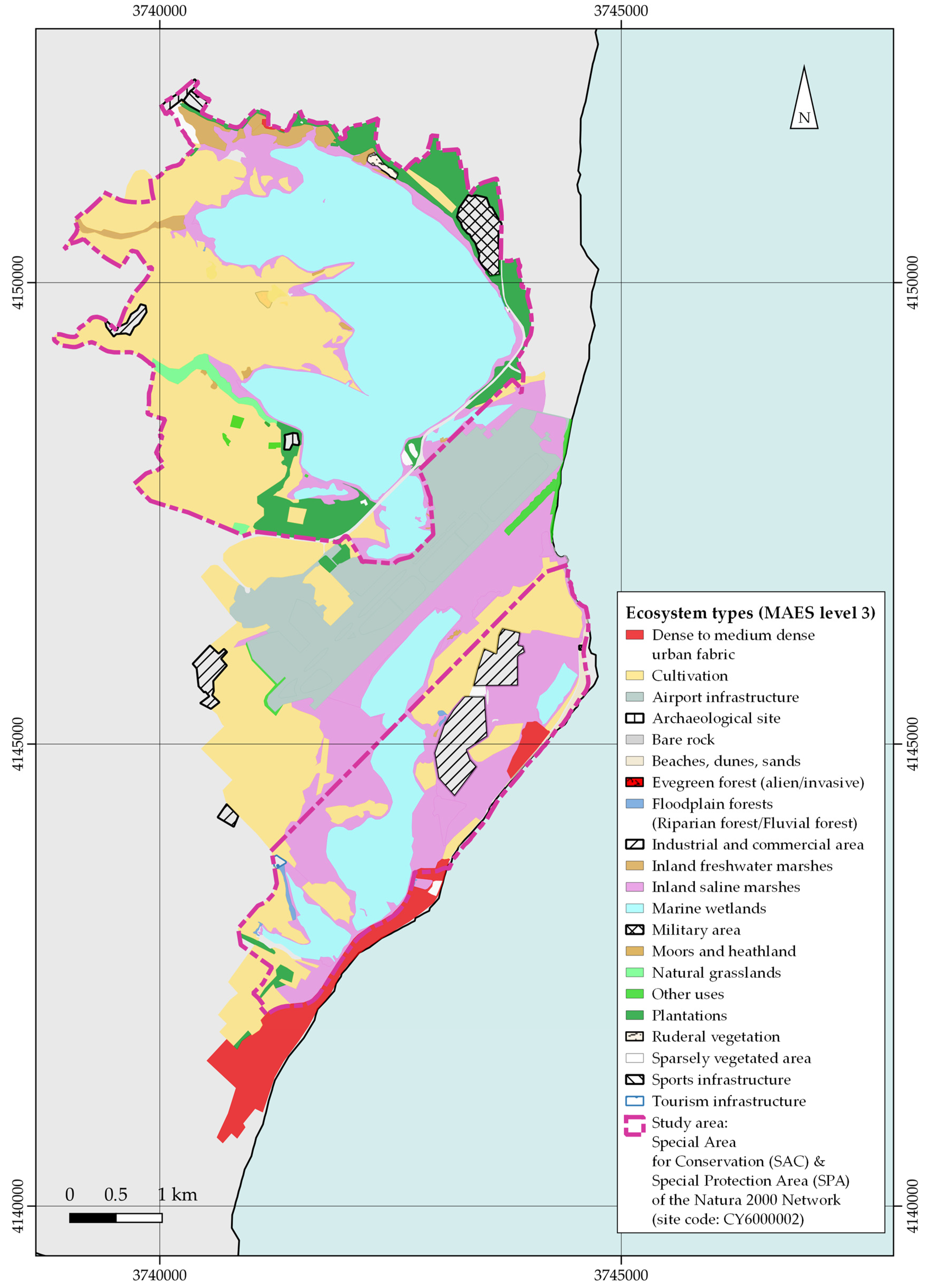
3.1. Ecosystem Type Mapping

In the area of Larnaca’s salt lakes, thirteen (13) natural habitat types have been identified (i.e., four character codes correspond to Natura 2000 habitat codes): (i) 1150 *coastal lagoons, (ii) 1210 drift line vegetation, (iii) 1310 Salicornia and other annuals colonizing mud and sand, (iv) 1410 Mediterranean salt meadows, (v) 1420 Mediterranean and thermo-Atlantic halophilous scrubs (Sarcocornetea fruticosi), (vi) 1430 Halo-nitrophilous scrubs (Pegano-Salsoletea), (vii) 2110 embryonic shifting dunes, (viii) 2260 Cisto-Lavenduletalia dune sclerophyllous scrubs, (ix) 5420 Sarcopoterium spinosum phryganas, (x) 6220 *pseudo-steppe with grasses and annuals (Thero-Brachypodietea), (xi) 92D0 southern riparian galleries and thickets (Nerio-Tamaricetea and Securinegion tinctoriae), (xii) CY02 reed beds, and (xiii) CY14 synanthropic communities, alongside human induced habitats and land uses. These habitat types and land uses have been accordingly assigned to the relevant ecosystem types as presented in Table 1 and are thematically illustrated in Figure 2. Cultivation is the prevailing ecosystem type, covering 31.01% of the area, followed by marine wetlands (26.83% of the area). Airport infrastructure covers 10.39% of the area, and inland saline marshes 17.14%; all other ecosystem types cover smaller areas, less than 5% each (most of them less than 1%).

3.2. Ecosystem Services Maps

The ecosystem services assessment, based on the CICES section level, revealed:
(a) Provisioning ecosystem services are mainly supported in the western part of the area (including the majority of cultivations) as well as some patches that can support grazing;
(b) Regulating and maintenance ecosystem services are mainly supported by natural ecosystems, with the marine wetlands (saline lakes), dunes, and natural grasslands presenting the highest score; however, cultivations of the area are considered valuable for supporting, regulating, and maintenance services, corresponding to a medium score;
(c) Cultural services are supported by marine wetlands, dunes, and natural grasslands (“very high” score), followed by floodplain forests (“high” score), moors, and heathland (“high” score), inland saline and freshwater marshes (“medium” score), and cultivations (“medium” score). All other ecosystems follow with lower scores.
In Figure 3, a thematic representation of the potential supply of the area’s ecosystem services is presented.
Salt lakes, the largest natural ecosystem of the area (745.01 ha, i.e., 26.83% out of total area) is highlighted as the most important, rated with a ‘very high’ score, both for regulating and maintenance as well as for cultural services.
It is also important to mention the contribution of cultivated land, the largest cultural, human induced ecosystem of the area (861.34 ha, i.e., 31.01% of the total area) to regulating and maintenance services, as well as to cultural services. This result can be interpreted due to the low pressures that current practices apply on natural habitats [19] and due to the different types of cultivation techniques (even some traditional ones).
Finally, areas with no potential (N/A), or with “very low” to “low” scores (i.e., the airport infrastructure, archaeological sites, dense to medium dense urban fabric, military area, sports infrastructure, tourism infrastructure, ruderal vegetation, alien/invasive vegetation, sparsely vegetated area, and bare rock) covered a significant part of the area (427.60 ha, i.e., 15.40% of the total area) and acted as borders and/or exclusion zones for ecosystem services in the pattern of the land use/land cover context.

3.3. Water Ecosystem Condition

(a) Water occurrence decrease intensity: The Global Surface Water Occurrence Change Intensity map [37] provides information on where surface water occurrence increased, decreased, or remained the same between 1984 and 1999 and 2000–2021. Using this GIS information, the percentage area change (i.e., decrease, increase, and no change, also including the % of the area with not enough data for consistency reasons), of each of Larnaca’s salt lake complex, was estimated and is shown in Table 2. An overall increase in the surface water occurrence for all salt lakes between 1984 and 1999 and 2000–2021 was designated.
The maximum water extent map [37] of the JRC Global Surface Water [37] shows the maximum extent of detected water over the 1984–2021 period. For Larnaca’s salt lakes, the corresponding results were assessed and are presented in Table 3. This can be used as the reference condition for the wetland ecosystem extent (water lake area extent).
The transitions map of the JRC Global Surface Water [37] was used to identify the percentage of the total lake area between seasonal, permanent and not water for each salt lake (Table 4). For example, Alyki Lake receives more than ¾ of its area of new seasonal water, at 20% of its area no water, and at circa 9%, ephemeral seasonal water. On the other hand, Spiros Lake receives no water at circa half of its area and to 40% of its area, ephemeral water.
The recurrence map of the JRC Global Surface Water [37] provides information concerning the inter-annual behavior of water surfaces and captures the frequency with which water returns from year to year (%). The water period runs from the first month in the first year in which water is observed to the last month of the last year in which water is observed of the entire 38-year period. The corresponding results for Larnaca’s salt lakes are presented in Table 5 in five range classes (see first column of Table 5). For example, for Alyki and Airport Lakes, circa 36% of their areas are covered with water with a frequency of above 75%; for Orfani Lake, circa 23% of its area; for all other lakes, below 15% of their area.
(b) Imperviousness of the wider wetland area: Soil sealing, expressed as ‘the substitution of the original (semi-)natural land cover or water surface with an artificial, often impervious cover, can be considered as a quantifiable indicator of the wetlands’ functional state, closely correlating with the impacts on water resources [39]. As levels of imperviousness increase, the wetland condition degrades [25]. A direct relationship was seen between wetland habitat quality and impervious surface area, with wetlands being impacted once the imperviousness of the local drainage basin exceeded 10% [40]. Based on the ecosystem type mapping of the extended area of the Larnaca‘s salt lakes, as described in Section 3.1, the individual impervious areas (as defined above), the total impervious area, and the imperviousness index as a percentage (total impervious area divided by the study area) is given in Table 6. The imperviousness (25.7%) was above the proposed 10% limit given by [40], therefore, a negative effect on the wetland habitat quality was identified. Moreover, it is worth mentioning that 0.365 km2 of Orfani Lake was lost after the construction of the International Airport of Larnaca, resulting in a circa 31% reduction in its lake area.
(c) Soil moisture deficit: Soil moisture is essential for the development of plants, the regulation of soil temperature, salinity, the availability of nutrients and the presence of toxic substances, and it gives structure to soil and contributes to preventing soil erosion [25]. The EEA annual soil moisture deficit during the vegetation growing season [41] from 2000 to 2022 shows the annual deviation in the soil moisture content of each 500-m grid cell from the long-term (1995–2019) average.
For Larnaca’s salt lakes, the mean EEA annual soil moisture deficit variable was estimated from 2009 to 2021 (the period overlapping with the WRF reporting period) and is presented in Table S1. To convert this variable to an appropriate SEEA EA ecosystem condition index, we proposed a five-class assessment as follows: (i) “bad” for variable values <0, (ii) “low” for values between 0 and 0.25, (iii) “medium” for values between 0.25 and 0.5, (iv) “good” for values between 0.5 and 0.75, and (v) “high” for values between 0.75 and 1. In 2000–2019, soil moisture in the growing season was several times below the long-term average in Larnaca’s salt lake complex. Table 7 shows the accounting table based on the mean EEA annual soil moisture deficit, for each Larnaca’s salt lake, its mean value for the overall salt lake complex, and the proposed index characterization, taking as opening stock the mean value for the period of the 1st RBMP (2009–2015), and the closing stock was the mean value for the period of the 2nd RBMP (2016–2021). In the closing period, the mean annual soil deficit soil, being ≤0, was lower than the opening period (>0), featuring a declining trend of the soil moisture in the growing season, being below the long-term average of the Larnaca’s salt lake complex for the closing period.
(d) Wetland connectivity: Wetland connectivity (Table 8), reflecting the probabilities of movement for animal species as well as the dispersal range of plants and invertebrate propagules [25], was estimated as the distance from one wetland to its nearest neighboring wetland [42]. The borders of the salt lakes’ water surface, as depicted in the wetland ecosystem mapping in Section 3.1, were used for the computation of the salt lakes’ distance. The presence of the airport between the two upper lakes (i.e., Alyki and Airport Lakes) and the other lakes should be considered together with the high distance between the lakes, since it disrupts their connectivity.
(e) Water status based on WFD reporting: Based on the reporting of the EU Member States within the framework of the Water Framework Directive (WFD) (Directive 2000/60/EC11), the surface water status based on: (a) the chemical status to refer to the environmental quality standards for annual average and maximum allowable concentrations of certain chemical substances, and (b) the ecological status referring to the quality of the structure and functioning of aquatic ecosystems, of the four main lakes (the Lake Spiros, due to its low lake area, is not included) is used as a measure of wetland health. Considering the WFD’s assessment philosophy determined by the poorer status of either the ecological or chemical status (see Table S2), the water condition of the salt lake ecosystems and its neighboring water bodies is provided synoptically using the five-class classification of water bodies (bad, poor, moderate, good, and high).
Considering the high uncertainty of the results due to insufficient data or/and lack of data and use of expert judgment, the ecological status of the salt lakes between the opening and the closing stock remained medium, whereas the chemical status changed from good to unknown. The marine water body, Episkopi (CY_9_C4), connected underground with the salt lakes, is in good state. The neighboring groundwater bodies (see [43]), Arapidou GW (CY-2), on the east of the salt lakes, is in good state and Kiti–Perivola (CY-3), on the south of the salt lakes, is in bad state. The river water bodies, interconnected (draining into) to the salt lakes (i.e., Tremithos River (r-8-4-3-40) (included in the 1st RBMP) and Kalo Chorio River (CY_8-3-a_RE) (included in the 2nd RBMP), have poor and medium ecological status and an unknown chemical status.

4. Discussion

The protected area of Alykes Larnakas is the most important green infrastructure of Larnaka city (alongside the blue infrastructure of the marine area). Study outcomes highlight that its proximity to the urban area provides opportunities for recreation, climate regulation, biodiversity and game maintenance, and control of the erosion rates, soil, and water quality. However, this proximity to the urban environment and human activities poses significant threats to ecosystems and their services, deteriorating the role of this unique green infrastructure in the Larnakas (as well as in the wider-area) socio-ecological context. This study points out that valuable sources of ES that are supported by the protected area are at stake, mainly due to water-related management and uses. The most recent management plan for the area [19] suggests a list of measures and actions to ameliorate the ecosystem condition based on scientific findings as well as on the opinions of the stakeholders and decision makers for the future development of the area. However, the complex proprietary status (e.g., cultivation and other uses of the protected area and in various spatial patterns) and the demand for the development of tourism activities (even of low impact alongside the seafront) challenges the immediate application of all measures and actions proposed in a hierarchical way and temporally scheduled by the area management plan. The results of this study act as an overview of the current condition, highlighting, under the ecosystem services and ecosystem condition accounting in the EU and international frameworks, important areas and tasks to be considered during the implementation of the management plan and of future conservation actions in the area. This work complements all other relevant efforts and provides guidance for decision and policymaking at the local scale.

4.1. Ecosystems and Ecosystem Services

Ecosystem types and ecosystem services mapping and assessment document the areas’ importance not only for conservation purposes (regulating and maintenance services) as well as for food production (provisioning services) and recreation/cultural activities, since it includes not only trails and paths for walking and hiking, sites for birdwatching, or beaches for sunbathing and swimming, but also host important religious and archeological monuments (cultural services).
The water ecosystem condition of the salt lakes is based on the assessment of the variables proposed in the EU-wide methodology for the mapping and assessment of the ecosystem condition for wetlands [25]. A decrease in the water occurrence intensity can assess the main aggregate property of the terrestrial part of the wetland ecosystem, identifying the sites where surface water occurrence has increased, decreased, or remained stable across 32 years [25]. Surface water occurrence changes can be attributed to anthropogenic and/or climatic change effects on wetlands. Any decrease in the surface water occurrence hence indicates a depletion in the ecosystem conditions [25]. An increase in the new seasonal water has been identified between the two time periods ((1984–1999) and (2000–2021)) provided from JRC’s Global Surface Water. A more detailed analysis of the water occurrence change within the WFD reporting period from 2009 to 2021 (for the two reporting periods, i.e., (2009–2015) and (2016–2021)) was not able due to the lack of sufficient annual mapping data for Larnaca’s salt lakes.
The transitions map of the JRC Global Surface Water provides information on the change in seasonality between the first and last years and captures changes between the classes of not water, seasonal water, and permanent water [44]. In this way, a deeper insight into the change in the seasonal (temporary) water surface of the salt lakes is provided. A diverse profile of the water type changes has been pointed out for the various salt lakes. The recurrence of the JRC Global Surface Water features the water frequency for the salt lakes, constituting useful statistical information, connecting the water surface area and its frequency.
Monitoring the pressure from soil moisture deficits can warn of potential impacts on plant development and soil health, supporting the assessment of drought-tolerant, resilient, and vulnerable ecosystems [45]. Negative soil moisture deficits show that the annual average availability of soil moisture to plants drops to such a level that it has the potential to affect terrestrial vegetation, and hence cause persistent changes in the ecosystem condition [25]. When negative long-term averages and negative trends in the annual data are identified, then increasing pressures on vegetation and ecosystems are also indicated. From this point of view, this variable represents a climatic driver that should be considered in EU nature restoration plans [44], informing policy action on ecosystem restoration in the EU, but also on adaptation to climate change [25]. This aspect is crucial since salt lakes support biota that is extremely ancient in an evolutionary sense (e.g., stromatolites and thrombolites), have physiological and biochemical mechanisms that enable them to tolerate high salt levels, and are highly sensitive to even small changes in the climate [13].
A simple ecosystem condition variable, reflecting the probabilities of movement for animal species as well as the dispersal range of plants and invertebrate propagules, is the wetland connectivity, broadly used as a wetland landscape/seascape indicator of the ecosystem condition [25]. A well-connected network of wetland habitats is crucial for the ecological functioning of this ecosystem since its deterioration can have a significant impact, for instance, on waterbird populations [46]. This variable can support decision making for restoring and maintaining connectivity patterns of the wetlands. For Larnaca’s salt lakes, a gross estimation of the distance between the lakes was possible, setting the reference condition for future temporal and spatial variations of the lakes’ water surface.
As deducted from the RBMPs’ synopsis of the salt lakes’ water status and their neighboring surface and groundwater bodies in this study, a high uncertainty of water status due to insufficient or complete lack of measurement for some of the required parameters hinders the integration and capitalization of this constant reporting dataset into the wetland ecosystem condition and water accounts. This has been also pointed out by [47] (i.e., “Data coming from WFD reporting obligations for wetlands cover only part of the whole ecosystem, with no consistent time series and are very fragmented”). In conclusion, these results provide the baseline for future assessments and supports national efforts for the implementation of MAES in Cyprus and can support the ongoing work of the relevant LIFE IP Physis (Pandoteira) project [48].

4.2. Raising Awareness

To safeguard saline lakes worldwide, society and governments must recognize their economic, cultural, and ecological values and decrease water development in their basins [16,49]. Stakeholder and public participation in decision-making processes is essential to reach successful management and policy decisions, especially for protected areas, where conservation benefits lay well beyond a particular area, especially when they are compared to the costs incurred by a smaller group of local stakeholders [50]. To build upon the great interest of local stakeholders and citizens for the sustainable development of the Alykes Larnakas wider area, concrete, scientifically-based information, well-documented and presented, is needed to adequately inform the participatory process. By this, informed and aware citizens and stakeholders will be able to constructively participate in the decision-making procedures; however, and given the fact that participation in such processes is a voluntary activity, it is crucial to identify who represents the general public, since there is a chance that participants either belong or not to the category of aware citizens [50]. This is the main reason that public and stakeholder awareness raising projects and campaigns should always be applied and developed hand-by-hand with conservation, development, and management efforts.

4.3. Management Implications

When saline lakes are desiccated, (i) the amount of habitat decreases and salinities can rise beyond the tolerance of these invertebrates, limiting both food and habitat for birds [51], (ii) they become sources of fine dust that harm human health [52] and agriculture [53], (iii) recreational activities (e.g., swimming, boating, fishing, birdwatching, and waterfowl hunting) are reduced or eliminated, and (iv) direct economic losses of mineral extraction, commercial fishery, harvesting the resting eggs (cysts) of brine shrimp is negatively associated with increased salinity [54]. The integrated management of terrestrial and aquatic ecosystems in the catchment area is required to preserve saline lake characteristics [54], focusing on the conservation of the fluctuation of the hydrological balance, avoiding or reducing water abstractions [17] and identifying the pollution sources and human-induced stresses. The improvement in water management and reuse of water, conservation measures, and the introduction of climate-smart agriculture are some of the basic proposed measures for sustaining healthy saline lake ecosystems. In response to concerns regarding the shrinking of saline lakes and the consequent impacts on the local environment, many ongoing national and sub-national efforts are aimed at increasing flows in upstream rivers [55,56].
The quantitative and qualitative water balance of the salt lakes is expected to change with the implementation of the storm water drainage system in western Larnaca, diverting a large part of Larnaca’s western area that is draining at present into the salt lakes [19]. Key management goals of the salt lake hydroecosystems should include, among others, the conservation of the constant hydrological status of the drying and filling of salt lakes, safeguarding a satisfactory conservation status of Anostraca Artemia salina and Phallocryptus spinosa. Moreover, the further increase in impervious areas between the salt lakes should be restricted to avoid negatively affecting the salt lakes’ connectivity. After the widespread clearance of the natural vegetation and other land-use changes within the catchments, the salinity of salt lakes can also increase because of secondary salinization [13].

4.4. Limitations of the Study

This study provides a first, generalized overview of the Alykes Larnakas ecosystems, trying to highlight the main issues for management handling and consideration. It should be noted that this study presents a snapshot of the ecosystem extent in the area, at a specific time; the mapping of ecosystems, especially of those related to the water balance, water level, and quality (i.e., wetland habitats), should also be mapped in temporal scales (e.g., within the different seasons of the year and for different years), in order to capture the changes over time. Regarding the mapping and assessment of ecosystem services, the present study provides a first approach to spatially present areas with the potential to support and provide different types of services; however, a field-based survey is required to obtain information for a more detailed identification, assessment, and trade-off analysis, using methods and platforms such as the one proposed by Kokkoris et al. [57], in combination with participatory mapping and assessment platforms and tools (e.g., see ppGIS-WebGIS [58] developed for the Greek LIFE IP 4 Natura project), to enrich the relevant geospatial information on ecosystem services. Additionally, the proposed set of ecosystem service indicators per ecosystem type and methods for their mapping, as provided by Vogiatzakis et al. [36], should be integrated in future studies and followed as a high priority task for the Alykes Larnakas area, in order to support evidence-based decision making. Moreover, the high interannual variations of the water surface of the temporary salt lakes set a great difficulty and an increased challenge in monitoring and identifying the temporal and spatial scales of these changes. The salt lakes directly reflect the climatic conditions (i.e., they shrink and grow with natural climatic variation) [10,59]. The herein computed variables of the wetland ecosystem condition, as proposed in the EU-wide framework [44], should be regularly updated and interpreted based on this limitation.

5. Conclusions

The present study highlights the ecosystem types and potential supply of ecosystem services in the area of Alykes Larnakas as the baseline information for future management decisions. It focuses on the water ecosystem, providing water-related ecosystem condition assessment and accounts for the wetlands of the salt lakes, following the SEEA EA international standards, as proposed in the EU-wide framework for the mapping and assessment of the ecosystem condition. Various ecosystem condition variables of the salt lakes have been evaluated based on existing datasets and scientific works. By this, it complements national efforts for the implementation of MAES in Cyprus, presenting a local scale study, which together with the Akrotiri salt lakes are the only natural lakes in the area under the effective control of the Government of the Republic of Cyprus. Moreover, this study acts as a pilot for saline lakes in the Mediterranean and points out their importance by presenting the first results from the southeast Mediterranean Sea. An alarming exceedance of the imperiousness (e.g., over 10%) and an increasing trend in the soil moisture deficit of the salt lake area (NATURA 2000 network area) and its surrounding region have been pointed out and can serve as appropriate and handy variables linked with the human, climate, and other impacts on the salt lakes’ ecosystem condition. Nevertheless, more detailed assessments for ecosystem services, based on fine-scale data and regular and systematic monitoring and mapping, are needed to provide evidence-based guidance for successful decision and policymaking.

Supplementary Materials

The following supporting information can be downloaded at: https://www.mdpi.com/article/10.3390/land12091781/s1, Table S1. Mean EEA annual soil moisture deficit for Larnaca’s salt lake complex, its mean value, and the proposed index characterization; Table S2: Water status based on the WFD reporting for the salt lakes’ ecosystem and the neighboring surface (river and marine) and groundwater bodies with opening stock referring to the period of the 1st RBMP (2009–2015) and closing stock to the period of the 2nd RBMP (2016–2021).

Author Contributions

Conceptualization, E.S.B. and I.P.K.; Methodology, E.S.B. and I.P.K.; Validation, C.S.C. and P.D.; Formal analysis, E.S.B. and I.P.K.; Investigation, E.S.B.; Resources, P.D. and C.S.C.; Data curation, E.S.B. and I.P.K.; Writing—original draft preparation, E.S.B. and I.P.K.; Writing—review and editing, All authors; Visualization, E.S.B. and I.P.K.; Supervision, P.D.; Project administration, P.D. and A.S.-L.; Funding acquisition, P.D. and A.S.-L. All authors have read and agreed to the published version of the manuscript.

Funding

This research received no external funding.

Data Availability Statement

Not applicable.

Conflicts of Interest

The authors declare no conflict of interest.

References

  1. Millenium Ecosystem Assessment. Ecosystems & Human Well-Being; Island Press: Washington, DC, USA, 2005. [Google Scholar]
  2. CBD. Kunming-Montreal Global Biodiversity Framework-Draft Decision Submitted by the President. In Proceedings of the Conference of the Parties to the Convention on Biological Diversitya, Montreal, QC, Canada, 7–19 December 2022; p. 14. [Google Scholar]
  3. Vlami, V.; Kokkoris, I.P.; Zogaris, S.; Cartalis, C.; Kehayias, G.; Dimopoulos, P. Cultural Landscapes and Attributes of “Culturalness” in Protected Areas: An Exploratory Assessment in Greece. Sci. Total Environ. 2017, 595, 229–243. [Google Scholar] [CrossRef] [PubMed]
  4. European Commission Communication from the Commission to the European Parliament, the Council, the European Economic and Social Committee and the Committee of the Regions Green Infrastructure (GI)—Enhancing Europe’s Natural Capital. Available online: https://eur-lex.europa.eu/legal-content/EN/TXT/?uri=CELEX%3A52013DC0249 (accessed on 13 June 2023).
  5. European Parliament Texts Adopted-Action Plan for Nature, People and the Economy-Wednesday, 15 November 2017. Available online: https://www.europarl.europa.eu/doceo/document/TA-8-2017-0441_EN.html (accessed on 13 June 2023).
  6. Hermoso, V.; Morán-Ordóñez, A.; Lanzas, M.; Brotons, L. Designing a Network of Green Infrastructure for the EU. Landsc. Urban Plan. 2020, 196, 103732. [Google Scholar] [CrossRef]
  7. Panagopoulos, Y.; Dimitriou, E. A Large-Scale Nature-Based Solution in Agriculture for Sustainable Water Management: The Lake Karla Case. Sustainability 2020, 12, 6761. [Google Scholar] [CrossRef]
  8. Ministry of Environment. Regional Planning and Public Works. In Final Study for the Construction of Karla’s Reservoir and the Accompanying Projects; Ministry of Environment: Athens, Greece, 2004. [Google Scholar]
  9. Bulgarian Ports Infrastructure Company. Demonstration of a Pilot Green Infrastructure as a Win-Win Solution for Biodiversity and Development in Lake Varna; Bulgarian Ports Infrastructure Company: Sofia, Bulgaria, 2022. [Google Scholar]
  10. Shadrin, N.; Anufriieva, E.; Gajardo, G. Ecosystems of Inland Saline Waters in the World of Change. Water 2022, 15, 52. [Google Scholar] [CrossRef]
  11. Rudneva, I.I.; Gaisky, P.V.; Shaida, V.G.; Shaida, O.V. Assessing Climate and Human Activity Effects on Hypersaline Lake Ecosystem: Case Study of Saki Lake, Crimea. Water 2023, 15, 456. [Google Scholar] [CrossRef]
  12. Berdugo, M.; Delgado-Baquerizo, M.; Soliveres, S.; Hernández-Clemente, R.; Zhao, Y.; Gaitán, J.J.; Gross, N.; Saiz, H.; Maire, V.; Lehman, A.; et al. Global Ecosystem Thresholds Driven by Aridity. Science 2020, 367, 787–790. [Google Scholar] [CrossRef]
  13. Finlayson, C.M. Salt Lakes. In The Wetland Book; Springer: Dordrecht, The Netherlands, 2016; pp. 1–12. [Google Scholar] [CrossRef]
  14. Ioannidou, I.; Manolaki, P.; Litskas, V.D.; Vogiatzakis, I.N. Temporary Salt Lakes: Ecosystem Services Shift in a Ramsar Site Over a 50-Year Period. Front. Ecol. Evol. 2021, 9, 410. [Google Scholar] [CrossRef]
  15. Bortels, L.; Chan, J.C.-W.; Merken, R.; Koedam, N. Long-Term Monitoring of Wetlands along the Western-Greek Bird Migration Route Using Landsat and ASTER Satellite Images: Amvrakikos Gulf (Greece). J. Nat. Conserv. 2011, 19, 215–223. [Google Scholar] [CrossRef]
  16. Williams, W.D. Environmental Threats to Salt Lakes and the Likely Status of Inland Saline Ecosystems in 2025. Environ. Conserv. 2002, 29, 154–167. [Google Scholar] [CrossRef]
  17. Lu, S.; Wang, Y.; Zhou, J.; Hughes, A.C.; Li, M.; Du, C.; Yang, X.; Xiong, Y.; Zi, F.; Wang, W.; et al. Active Water Management Brings Possibility Restoration to Degraded Lakes in Dryland Regions: A Case Study of Lop Nur, China. Sci. Rep. 2022, 12, 18578. [Google Scholar] [CrossRef]
  18. Lyratzaki, I.; Dodouras Photos, S.; Dodouras, S.; Ioannou, A.; Fischer, P.; Michaelides, A.; Sozou, E. Cultural Heritage Um Haram Shrine-Hala Sultan Tekke, In Programm “Culture and wetlands in the Mediterranean: Using cultural values for wetland restoration”, Med-INA. Available online: https://med-ina.org/wp-content/uploads/2019/11/Larnaka-leaflet-f.pdf (accessed on 10 July 2023).
  19. Dimopoulos, P.; Pappas, E.; Katsimanis, N.; Kehayias, G.; Kokkoris, I.; Panagiotou., N.; Foui, E.; Aleksandropoulou, E.; Zacharaki, T. Revision of the Management Plan of the Network NATURA 2000 Area “Alykes Larnakas”; I.A.CO Ltd.: Nicosia, Cyprus, 2016. [Google Scholar]
  20. Karavokiris, G.; Kaimaki, R.S. Provision of Consulting Services for Result Assessment of Monitoring Programmes for Surface Waters within the Article 8 of WFD 2000/60/EC; Ministry of Agriculture, Natural Resources and Environment, Department of Water Development: Nicosia, Cyprus, 2009. [Google Scholar]
  21. Tziortzis, I. Monitoring of Ecological Quality of Coastal Ecosystems in Greece and Cyprus in the Framework of the Implementation of Water Framework Directive 2000/60/EC for Water; Lagoons Kotichi-Prokopos and Alykes Larnaca-Akrotiriou; University of Patras: Patras, Greece, 2008. [Google Scholar]
  22. Fotiou, M. Characterisation and Dynamics of Brine Shrimps in Alykes Larnacas; Department of Biology, Aristotle University of Thessaloniki: Thessaloniki, Greece, 2013. [Google Scholar]
  23. Hatzichristophourou, M. Larnacas Salt Lakes; Nicosia, Cyprus, 2007. [Google Scholar]
  24. Hatzistefanou, N. Study on Alykes Larnacas Salt Lakes Ecosystem, Cyprus, with Emphasis on Artemia Population; National and Kapodistrian University of Athens: Athens, Greece, 1989. [Google Scholar]
  25. Vallecillo, S.; Maes, J.; Teller, A.; Babí Almenar, J.; Barredo, J.I.; Trombetti, M.; Malak, A. EU-Wide Methodology to Map and Assess Ecosystem Condition. In Towards a Common Approach Consistent with a Global Statistical Standard; Publications Office of the EU: Luxembourg, 2022. [Google Scholar] [CrossRef]
  26. United Nations. (UN) System of Environmental-Economic Accounting—Ecosystem Accounting (SEEA EA); White Cover Publication, Pre-Edited Text Subject to Official Editing; United Nations: New York, NY, USA, 2021. [Google Scholar]
  27. Devillers, B.; Brown, M.; Morhange, C. Paleo-Environmental Evolution of the Larnaca Salt Lakes (Cyprus) and the Relationship to Second Millennium BC Settlement. J. Archaeol. Sci. Rep. 2015, 1, 73–80. [Google Scholar] [CrossRef]
  28. Delipetrou, P.; Christodoulou, C.S. Guide to Identifying and Mapping the Habitats of Annex I of Directive 92/43/EEC in Cyprus; Department of Environment, Ministry of Agriculture: Nicosia, Cyprus, 2010. [Google Scholar]
  29. Delipetrou, P.; Chatzichampis, A. Monitoring Plan for the Halophytic Habitats of the Larnaca Salt Lakes Wetland; 2007.
  30. Kokkoris, I.P.; Mallinis, G.; Bekri, E.S.; Vlami, V.; Zogaris, S.; Chrysafis, I.; Mitsopoulos, I.; Dimopoulos, P. National Set of MAES Indicators in Greece: Ecosystem Services and Management Implications. Forests 2020, 11, 595. [Google Scholar] [CrossRef]
  31. Linkages of Species and Habitat Types to MAES Ecosystems—European Environment Agency. Available online: https://www.eea.europa.eu/data-and-maps/data/linkages-of-species-and-habitat (accessed on 9 July 2023).
  32. Google Earth. Available online: https://earth.google.com/web/@0,-1.40880005,0a,22251752.77375655d,35y,0h,0t,0r (accessed on 9 July 2023).
  33. Welcome to the QGIS Project! Available online: https://qgis.org/en/site/ (accessed on 9 July 2023).
  34. Haines-Young, R.; Potschin, M.B. Common International Classification of Ecosystem Services (CICES) V5. 1 and Guidance on the Application of the Revised Structure; Fabis Consulting Ltd.: Nottingham, UK, 2018. [Google Scholar]
  35. Kokkoris, I.P.; Drakou, E.G.; Maes, J.; Dimopoulos, P. Ecosystem Services Supply in Protected Mountains of Greece: Setting the Baseline for Conservation Management. Int. J. Biodivers. Sci. Ecosyst. Serv. Manag. 2018, 14, 45–59. [Google Scholar] [CrossRef]
  36. Vogiatzakis, I.N.; Zotos, S.; Litskas, V.D.; Manolaki, P.; Sarris, D.; Stavrinides, M.C. Towards Implementing Mapping and Assessment of Ecosystems and Their Services in Cyprus: A First Set of Indicators for Ecosystem Management. One Ecosyst. 2020, 5, e47715. [Google Scholar] [CrossRef]
  37. Pekel, J.F.; Cottam, A.; Gorelick, N.; Belward, A.S. High-resolution mapping of global surface water and its long-term changes. Nature 2016, 540, 418–422. [Google Scholar] [CrossRef]
  38. Water Framework Directive|Home Page. Available online: http://www.moa.gov.cy/moa/WDD/wfd.nsf/home_en/home_en?opendocument (accessed on 9 July 2023).
  39. Arnold, C.L., Jr.; Gibbons, C.J. Impervious Surface Coverage: The Emergence of a Key Environmental Indicator. J. Am. Plan. Assoc. 1996, 62, 243–258. [Google Scholar] [CrossRef]
  40. Hicks, A.L.; Larson, J.S.; Von Nebeker, A. Impervious Surface Area and Benthic Macroinvertebrate Response as an Indicator of Impact from Urbanization of Freshwater Wetlands; US Environmental Protection Agency, Office of Research and Development: Washington, DC, USA, 1995. [Google Scholar]
  41. Files-SDI Datashare. Available online: https://sdi.eea.europa.eu/data/0fa3c2b0-cfbc-474a-a96c-1ec86f9cac24 (accessed on 9 July 2023).
  42. Calabrese, J.M.; Fagan, W.F. A Comparison-shopper’s Guide to Connectivity Metrics. Front. Ecol. Environ. 2004, 2, 529–536. [Google Scholar] [CrossRef]
  43. Groundwater Bodies of Cyprus. Available online: http://www.moa.gov.cy/moa/wdd/wdd.nsf/All/1253ACB7F4BE524AC225839F002F98E0/$file/GW_bodies_FINAL_1st_Sxedio_2015_26oct_2020.pdf?OpenElement (accessed on 9 July 2023).
  44. Vallecillo, S.; La Notte, A.; Ferrini, S.; Maes, J. How Ecosystem Services Are Changing: An Accounting Application at the EU Level. Ecosyst. Serv. 2019, 40, 101044. [Google Scholar] [CrossRef]
  45. Anderegg, W.R.L.; Kane, J.M.; Anderegg, L.D.L. Consequences of Widespread Tree Mortality Triggered by Drought and Temperature Stress. Nat. Clim. Chang. 2013, 3, 30–36. [Google Scholar] [CrossRef]
  46. Merken, R.; Deboelpaep, E.; Teunen, J.; Saura, S.; Koedam, N. Wetland Suitability and Connectivity for Trans-Saharan Migratory Waterbirds. PLoS ONE 2015, 10, e0135445. [Google Scholar] [CrossRef]
  47. Maes, J.; Teller, A.; Erhard, M.; Conde, S.; Vallecillo, S.; Barredo, J.I.; Paracchini, M.-L.; Abdul Malak, D.; Trombetti, M.; Vigiak, O. Mapping and Assessment of Ecosystems and Their Services: An EU Wide Ecosystem Assessment in Support of the EU Biodiversity Strategy; Publications Office of the European Union: Ispra, Italy, 2020. [Google Scholar]
  48. Homepage-Pandoteira. Available online: https://pandoteira.cy/ (accessed on 9 July 2023).
  49. Wurtsbaugh, W.A.; Sima, S. Contrasting Management and Fates of Two Sister Lakes: Great Salt Lake (USA) and Lake Urmia (Iran). Water 2022, 14, 3005. [Google Scholar] [CrossRef]
  50. Kokkoris, I.P.; Skuras, D.; Maniatis, Y.; Dimopoulos, P. Natura 2000 Public Awareness in EU: A Prerequisite for Successful Conservation Policy. Land Use Policy 2023, 125, 106482. [Google Scholar] [CrossRef]
  51. Wurtsbaugh, W.A.; Miller, C.; Null, S.E.; Derose, R.J.; Wilcock, P.; Hahnenberger, M.; Howe, F.; Moore, J. Decline of the World’s Saline Lakes. Nat. Geosci. 2017, 10, 816–821. [Google Scholar] [CrossRef]
  52. Griffin, D.W.; Kellogg, C.A. Dust Storms and Their Impact on Ocean and Human Health: Dust in Earth’s Atmosphere. EcoHealth 2004, 1, 284–295. [Google Scholar] [CrossRef]
  53. Micklin, P. The Aral Sea Disaster. Annu. Rev. Earth Planet. Sci. 2007, 35, 47–72. [Google Scholar] [CrossRef]
  54. Comín, F.A.; Cabrera, M.; Rodó, X. Saline Lakes: Integrating Ecology into Their Management Future. In The Ecological Bases for Lake and Reservoir Management; Springer: Dordrecht, The Netherlands, 1999; pp. 241–251. [Google Scholar] [CrossRef]
  55. Hassani, A.; Azapagic, A.; D’Odorico, P.; Keshmiri, A.; Shokri, N. Desiccation Crisis of Saline Lakes: A New Decision-Support Framework for Building Resilience to Climate Change. Sci. Total Environ. 2020, 703, 134718. [Google Scholar] [CrossRef]
  56. Hamidi-Razi, H.; Mazaheri, M.; Carvajalino-Fernández, M.; Vali-Samani, J. Investigating the Restoration of Lake Urmia Using a Numerical Modelling Approach. J. Great Lakes Res. 2019, 45, 87–97. [Google Scholar] [CrossRef]
  57. Kokkoris, I.P.; Kokkinos, V.; Michos, E.; Kalogeropoulos, R.; Charalambides, M.; Kounelis, A.; Iliadou, E.; Damianidis, C.K.; Mallinis, G.; Bouras, C. MAES_GR: A Web-Based, Spatially Enabled Field Survey Platform for the MAES Implementation in Greece. Land 2021, 10, 381. [Google Scholar] [CrossRef]
  58. Roustanis, T.; Chalkidou, E.; Tselepis, S.; Kokkoris, I.P.; Dimopoulos, P.; Kavvadia, A.; Mitsopoulos, I.; Mallinis, G. Technical Report on the PPGIS-WebGIS Development. LIFE-IP 4 NATURA: Integrated Actions for the Conservation and Management of NATURA 2000 Sites, Species, Habitats and Ecosystems in Greece (LIFE16 IPE/GR/000002). Deliverable of Action C.4.; Aristotle University of Thessaloniki: Thessaloniki, Greece, 2021. [Google Scholar]
  59. Gajardo, G.M.; Sorgeloos, P.; Beardmore, J.A. Inland Hypersaline Lakes and the Brine Shrimp Artemiaas Simple Models for Biodiversity Analysis at the Population Level. Saline Syst. 2006, 2, 14. [Google Scholar] [CrossRef]
Figure 1. Map of the study area. (1) Alyki Lake, (2) Airport Lake, (3) Lake Orfani, (4) Lake Soros, (5) Lake Spiros.
Land 12 01781 g001
Figure 2. Ecosystem type map (MAES level 3) of the study area.
Land 12 01781 g002
Figure 3. The potential supply of ecosystem services in the study area. (a) Provisioning services. (b) Regulating and maintenance services. (c) Cultural services.
Land 12 01781 g003
Table 1. Ecosystem type (MAES level 2 and level 3) area and their corresponding percentage of the total mapped study area.
MAES Level 2 Ecosystem TypesHabitat Types and Land Use CodesMAES Level 3 Ecosystem TypesArea (ha)% Total
UrbanA/PAirport infrastructure288.6410.39%
ARCArcheological site4.880.18%
BDense to medium dense urban fabric97.193.50%
IIndustrial and commercial area66.542.40%
MMilitary area20.330.73%
SSports infrastructure2.510.09%
HTourism infrastructure1.010.04%
CroplandCCultivation861.3431.01%
Grassland6220 *Natural grasslands17.910.65%
CY14Ruderal vegetation2.760.10%
Heathland and shrub5420Moors and heathland2.370.09%
Woodland and forestACAEvergreen forest (alien and invasive)1.320.05%
92D0, 92D0 × 1420Floodplain forests (riparian forest/fluvial forest)3.260.12%
PLPlantations126.254.55%
Sparsely vegetated land8250Bare rock0.810.03%
1210, 2110Beaches, dunes, sands7.590.27%
FSparsely vegetated area8.170.29%
WetlandCY02Inland freshwater marshes30.271.09%
1310, 1410, 1420, 1420 × 1410, 1420 × 92D0, 1430Inland saline marshes476.0517.14%
1150 *Marine wetlands745.0126.83%
OtherXOther uses13.070.47%
*: Priority habitat types for conservation in the EU. The four-character codes correspond to the Natura 2000 habitat codes; all other codes are abbreviations for the MAES level 3 ecosystem types.
Table 2. Water occurrence decrease intensity (Global Surface Water, JRC) (%).
OrfaniSorosAlikiAirport Spiros
Decrease0.10.00.00.50.0
No change0.00.00.10.00.0
Increase69.942.882.072.849.5
Not enough data 30.057.218.026.750.5
Table 3. Maximum water extent (km2) for Larnaca’s salt lake complex.
Larnaca Salt Lakes ContentOrfaniSorosAlikiAirportSpiros
Maximum water area extent (km2)1.5010.1864.4670.2140.217
Table 4. Transitions as changes between the classes of not water, seasonal water, and permanent water (Global Surface Water, JRC) (%) for Larnaca’s salt lake complex.
Transitions (Global Surface Water, JRC) (%)
OrfaniSorosAlikiAirport Spiros
Not water29.857.217.924.949.3
Seasonal1.00.00.123.10.3
New seasonal50.037.973.342.77.8
Lost seasonal0.20.00.01.41.5
Ephemeral
seasonal
18.94.98.68.041.0
Table 5. Recurrence (%) (Global Surface Water, JRC) (%) for Larnaca’s salt lake complex.
Transitions (Global Surface Water, JRC) (%)
OrfaniSorosAlikiAirport Spiros
0%68.181.655.359.763.3
1–25%0.00.00.00.00.0
26–50%2.40.13.11.76.0
51–75%6.22.55.52.517.0
76–100%23.315.936.136.213.7
Table 6. Impervious areas (km2) within Larnaca’s salt lake complex and imperviousness index (%).
AirportResidential ZoneHotel ZoneArcheological Zone Military ZoneIndustrial and Commercial ZoneTotal Impervious AreaStudy AreaImperviousness (%)
Area (km2)5.5780.7950.0010.0400.1660.5457.12427.68325.7
Table 7. Accounting table based on the wetland variable, the mean EEA annual soil moisture deficit, for each Larnaca salt lake, its mean value for the overall salt lake complex, and the proposed index characterization with opening stock for the time period of the 1st RBMP (20092015) and closing stock for the time period of the 2nd RBMP (20162021).
Orfani SorosAlikiAirportSpirosMean Value for Larnaca’s Salt LakesStatus Characterization
Opening stock
(2009–2015)
0.1650.1720.1020.2250.1370.160POOR
Closing stock
(2016–2021)
0.008−0.081−0.1570.075−0.003−0.032BAD
Table 8. Wetland connectivity as a distance (m) between the limits of the water surface area of each lake.
Connected Salt LakesAlyki–AirportAirport–OrfaniAirport–SpirosOrfani–SorosOrfani–Spiros
Wetland connectivity (m)407002000701200
Disclaimer/Publisher’s Note: The statements, opinions and data contained in all publications are solely those of the individual author(s) and contributor(s) and not of MDPI and/or the editor(s). MDPI and/or the editor(s) disclaim responsibility for any injury to people or property resulting from any ideas, methods, instructions or products referred to in the content.

