Article

Historical Memory as an Effective and Useful Tool for Proper Land Use Planning: Lessons Learnt from Some Italian Cases

1
Istituto di Ricerca per la Protezione Idrogeologica, Consiglio Nazionale delle Ricerche, Strada della Cacce 73, 10135 Torino, Italy
2
Istituto di Scienze del Patrimonio Culturale, Consiglio Nazionale delle Ricerche, C.da S. Loja, 85050 Potenza, Italy
3
Istituto di Studi sul Mediterraneo, Consiglio Nazionale delle Ricerche, Via Guglielmo Sanfelice, 8, 80134 Napoli, Italy
4
Istituto di Scienze dell’Alimentazione, Consiglio Nazionale delle Ricerche, Via Roma 64, 83100 Avellino, Italy
5
INGV, Osservatorio Vesuviano, Via Diocleziano 328, 80124 Napoli, Italy
*
Author to whom correspondence should be addressed.
Land 2023, 12(9), 1751; https://doi.org/10.3390/land12091751
Submission received: 7 July 2023 / Revised: 28 August 2023 / Accepted: 3 September 2023 / Published: 8 September 2023

Abstract

:
Many Italian cities and towns have been affected by geological or geohydrological processes. However, due to the loss of historical memory, lessons of the past have been ignored; new urbanized areas have expanded into the same zones where damage and casualties occurred in the past. Despite current practices, researchers are showing how historical data can be among the most valid tools for identifying the most affected and hazardous areas. When the completeness and quality of historical sources are sufficiently high, we can make useful statistical inferences regarding the spatiotemporal variations of natural processes. This information is of great importance for land use planning, as it makes us able to rely not only on the current state of the investigated areas but also on their dynamic evolutionary framework over time. In this article, we present a chronological review of past Italian works describing the occurrence of natural extreme events making use of historical data. Then, we present some Italian case studies in which the awareness of hazards gained by paying attention to past information would have ensured better management of the risk for the benefit of public safety. Finally, the authors stress the need to safeguard, manage, and enhance the large collection of historical data that constitutes Italy’s heritage.

1. Introduction

Italy is a young peninsula from a geological point of view: its shape and physical configuration originate from the collision between the African and Eurasian plates that occurred during the Cenozoic. This geological event caused the closure of the Tethys Sea and was accompanied by the compression and piling up of its sediment, which determined the formation of the two important mountain chains that now characterize the Italian territory: the Alps and the Apennines [1,2]. This tectonic evolution is still ongoing, causing remarkable seismic and volcanic activity, which threatens human settlements and activities. The diversity of the Italian landscape is also due to the wide variety of lithotypes, including pre-orogenic basement and successive sedimentary cover [3,4]. This situation, combined with the high population density, especially distributed in coastal areas, makes the peninsula particularly vulnerable to extreme natural events, such as earthquakes and volcanic eruptions, as well as landslides, mud debris flows, and floods.
Looking at Catalogo Parametrico dei Terremoti Italiani (Parametric Catalogue of Italian Earthquakes) [5], we can easily see that earthquakes often occur in areas that have already been shaken by past events. The strongest historical events occurred in Sicily, in the eastern Alps, and along the central–southern Apennines, from Abruzzo to Calabria. However, major earthquakes have also hit the northern–central Apennines and the Gargano (Apulia) promontory.
Specifically, 75 earthquakes from medium to high magnitude (Mw ≥ 5.5) have occurred since 1900, some of which caused heavy losses and had significant environmental effects. The strongest of these was the Mw 7.1 earthquake that destroyed Messina and Reggio Calabria in December 1908 [5,6,7,8,9,10], causing about 80,000 deaths.
In the last 60 years, the most damaging earthquakes occurred on 6 May 1976 in Friuli Venezia Giulia (Mw 6.5, 989 casualties) [5,11,12], on 23 November 1980 in the Campania–Basilicata region (Mw 6.9, 2914 victims) [5,13,14,15,16], and on 6 April 2009 in Abruzzo (Mw 6.3, 309 victims) [5,17,18], as well as the 2016–2017 seismic sequence in Central Italy (299 victims) [5,19,20,21,22].
However, it should not be forgotten that Italy also has many volcanoes, at least 10 of which are “active” (which means that they have “woken up” at least once in the last 10,000 years): Etna, Stromboli, Vesuvius, Ischia, Lipari, Vulcano, Pantelleria, Colli Albani, Campi Flegrei, and Isola Ferdinandea. The only two that currently erupt continuously, separated by short intervals, are Etna and Stromboli. When we consider volcanic eruptions that occurred historically in Italy, we are immediately reminded of 79 BC, when there was the great eruption of Vesuvius, which buried the nearby cities of Pompeii and Herculaneum under a cloud of ash and pumice rocks, causing thousands of casualties (based on descriptions in two Epistulae by Gaius Plinius Caecilius Secundus). Vesuvius has apparently been “dormant” (which does not mean extinct) since 1944, but it is perfectly active [23]; the risk linked to Vesuvius is determined by the fact that a densely settled area has developed around it over the centuries, with millions of inhabitants. Mount Etna, in Sicily, is the largest active volcano. The most impressive effusive eruption of Etna in historical times took place in 1669 [24], when lava buried numerous villages, reaching as far as the sea near Catania, with a flow up to 17 km long but without casualties. In recent decades, only Etna and Stromboli have erupted. Etna is usually active, sometimes more so, sometimes less so. In 1979, Mount Etna had a sudden explosion that caused 9 deaths and 23 injuries among a group of tourists on an excursion [25,26]; at that time, the last official order for the evacuation of a town due to an eruption was issued.
In addition to endogenous phenomena, exogenous phenomena also contribute to increasing the risk. Every year, in Italy, hundreds of floods and thousands of landslides occur, affecting the environment and causing severe damage and casualties. The reason for such activity is that Italy is a peninsula with a highly articulated and complex hydrographic network. There are about 1200 rivers, 57 of which are longer than 100 km. Therefore, thousands of torrents and streams make up a very dense network. This inevitably brings a high risk of possible flooding for a large part of the peninsula. In conjunction with rainy periods, landslides can be triggered; they are superficial if the rainfall is short and intense, and deeper if the rainfall lasts for several days. For this reason, we treat them together, defined as geohydrological processes [27].
Although geohydrological processes have been occurring since remote times, they have accelerated considerably since around the end of World War II [28], with numerous serious geohydrological processes devastating Italy, in terms of both human victims and damage to structures and infrastructure. However, it is important to distinguish the different phenomena: on one hand, landslides, mudflows, and debris flows, and on the other hand, floods.
Regarding landslides, the most damaging event, which was world-renowned and widely studied, was the Vajont landslide (Friuli Venezia Giulia, Northern Italy) on 9 October 1963. It is one of the largest mass movements ever to occur in Italy (about 240 million m3). Earth that detached from the slope fell into a large hydroelectric reservoir. The resulting water wave passed over the dam and poured over the Piave Valley floor, sweeping away many villages; in total, 1911 casualties were reported [29,30], but there were probably more.
Concerning mudflows and debris flows, one of the most catastrophic events (considered anthropogenic) took place in July 1985 in Prestavel (Trentino, Northern Italy), when a huge mudflow occurred. The tailing ponds of the Prestavel fluorite mine broke their banks, discharging 180,000 m3 of mud in a matter of minutes onto the small tourist village of Stava. Many houses and hotels were razed to the ground, and there were 269 casualties and many injuries [31,32].
Another large mudflow struck several towns in Campania (Southern Italy), including Sarno, in May 1998. Numerous mudflows invaded the villages, rapidly filling houses and causing as many as 160 casualties [33,34].
Italy also has a very long history of floods. Since the end of the Second World War, some noteworthy floods have occurred. In particular, in November 1951, the famous Polesine (Veneto) flood caused 100 deaths (84 died on a truck). About 100,000 hectares was flooded, and 5674 houses were destroyed or damaged; a total of 33% of the population was forced to leave Polesine after the flood [35].
Fifteen years later, in November 1966, the great flood of Florence occurred (which also involved Veneto, Trentino, and Friuli), with 111 casualties [36]. This flood greatly shocked the international community, especially because of the serious damage to art museums and the national library of Florence [37]. Lastly, we also remember the two great floods of 1994 and 2000 that hit Piedmont in particular, causing very serious damage, with 69 casualties (1994) [38] and 36 casualties (2000) [39,40].
Knowledge of the above-mentioned endogenous and exogenous phenomena was possible thanks to the extensive and critical use of historical sources, in which Italy is particularly rich. The wealth of written sources and their widespread availability come from the different foreign rules and subsequent administrative structures that have succeeded one another over the centuries.
Historical sources can be used to identify urban areas that were affected by extreme natural events in the past; thus, we can understand the impact that these events had on humanity, the built environment, and the territory. The aim is to obtain a powerful tool to prevent the occurrence of hazards and mitigate risks. With this in mind, in this article, we discuss five case studies scattered throughout the peninsula dealing with processes that differ in terms of type, evolution, kinematics, and damage. The five case studies, covering areas affected by both hydrogeological and seismic hazards, can be considered illustrative of how knowledge of the memory of places and humanity’s respect for the natural evolution of the territory would have contributed to mitigating the risk of natural hazards to prevent disasters.
Following the Section 1, the article is divided into four main parts: (a) an overview of the main works that made use of historical sources to report on the occurrence of natural hazards in Italy; (b) the Section 3, which describes the approach followed to analyze the five case studies; (c) the Results section, in which the natural hazards that occurred at each of the five sites are analyzed, along with the role of humans in mitigating risks (or not); (d) the Section 5, which provides a critical analysis of the five case studies; and (e) the Section 6, in which the authors sum up the research and propose concrete actions of interest to stakeholders and policymakers with regard to improving the management of natural risks.

2. Pioneers in the Use of Historical Sources to Study Natural Hazards in Italy: An Overview

In past centuries, Italian scholars dealt with natural extreme events, which attracted their interest based on the causes of natural processes and their possible repetitiveness over time. Certainly, geological and geomorphological phenomena are among the events that cause concern and spark the imagination; thus, information about them is worth handing down, and people have frequently had the propensity to pass on significant events they have witnessed to posterity. Often, those who witnessed the effects of extreme natural events felt the desire and the need to leave a testimony, perhaps a long narrative or even a simple description of, for example, the exceptional height reached by the waters of a river or the effects of an earthquake or a landslide on a certain area or town.

2.1. Floods and Landslides

For example, browsing through the pages of an anthology of ancient Latin poets, we can find this passage by Silius Italicus in his Punica Liber IV [41], which refers to the Battle of the Trebbia, which took place on 25 December in 218 BC. In epic form, the author describes a violent raging of the river that caused the death of numerous soldiers (Figure 1). Gaius Plinius Caecilius Secundus [42], in his Naturalis Historia, told of a landslide that during the great eruption of Vesuvius prevented people from approaching the shoreline. [43]. The poet Dante Alighieri, in Inferno, the first canticle of The Divine Comedy (about 1320) [44], could not fail to mention the “ruina di Marco” near Rovereto (Trento province, Northern Italy), an area he had known during his travels. It was an area of more than 35 hectares where cyclopean boulders detached from Monte Zugna and were carried downstream by water, diverting the course of the Adige River in prehistoric times [45], an event so terrifying that Dante had to mention it.
We can consider the attention paid by the people of Rome, more than 800 years ago, to the heights reached by the waters of the Tiber in the “Urbs Aeterna”. Today, walking some distance from the Tiber’s riverbed, we can still find some epigraphs, the so-called “flood notches”, known also as “little hands”, indicating the height reached by the Tiber in the city. Many epigraphs can also be found on the façade of the Basilica di Santa Maria sopra Minerva in Piazza della Minerva, near the Pantheon. The oldest marble plaque, placed at Castel Sant’Angelo, recalls the flood of 6 November 1277, although written sources mention that older flood notches were once present and later disappeared [46].
In Florence, there are also many epigraphs testifying to the various floods of the Arno that hit the city over the centuries. The oldest is from 1333 [47], and the great floods that followed, which occurred in 1547, 1557, 1589, 1740, and 1758 and on 3 November 1844, are commemorated by plaques. The Florence municipality made a census of the epigraphs, and georeferenced them to implement the data in a Web GIS [48]. The Web GIS reports include, in addition to the geographic coordinates of each epigraph’s location, the details of the information on the plaque, such as the date of the flood and, above all, the height reached by the floodwaters.
In the Roman period, descriptions of Tiber floods were recorded by Titus Livius (at least eight before 189 BC), Horace and Dione Cassius (nine around the time of Christ’s birth), and other Latin authors such as Tacitus and Plinius [49]. Floods in the medieval period and up to 1870 were studied and reported by contemporary writers such as Castiglione [50] and Bonini [51]. Later, other historians sporadically described the floods they witnessed. The records of the earliest period, up to 1870, are essentially based on the chronicles of floods in Rome and the records of flood levels handed down through the generations, as attested by the many tombstones that can still be seen today. Although height measurements from the first hydrometer in Ripetta (Cavour bridge in Rome) have existed since 1782, it was not until 1871, following the great flood of 29 December 1870, that the Ministry of Public Works began to systematically observe the river level daily under normal conditions and hourly during floods, as Di Loreto and Bersani [49] recently reported.
Descriptions of the old catastrophic floods of the Arno River in Florence were published in 1762 by Ferdinando Morozzi [52], a hydraulic engineer, and the work was later resumed in 1845 by Giuseppe Aiazzi [53]. Some historians have gone further, not limiting themselves to describing just one episode [54] but describing in detail different areas of specific regions [55], also mentioning the various disasters that affected the territory. For example, Goffredo Casalis [56], an Italian abbot and historian, completed a tremendous 31-volume work that has become a touchstone for historical research. His dictionary illustrated the civil conditions of every inhabited part of the Sardinian Kingdom, which included four regions of present-day Italy and part of Switzerland and France. Casalis described the morphological characteristics, the geographical position, and the climate of each one; the information is completed by descriptions of historical events of each country, including extreme natural events such as landslides and floods.
Pantanelli and Santi [57], late-19th-century scholars, writing about the Emilian Apennines, stressed that “all or almost all the big landslides of our day are nothing more than a renewal of landslides occurred in periods before the nineteenth century” (translated from Italian).
Shortly thereafter, Santi [58] cited ancient gravitational movements in the Modena area, which destroyed fortresses and towns. Following Santi, there were also numerous reports by Almagià (1907, 1910) in his two important volumes [59,60] focusing on landslides in the Apennine chain.
In 1900, Comandini and Monti [61] published a significant collection of data related to Italy throughout the 19th century. After reviewing many sources (journal articles, books, technical reports) in their work, they provided a good synthesis of all the events for which they had found at least one record, listing all of the storms; dry, rainy, hot, and cold periods; and hydrogeological processes.
Three years later, Berta [62] published a volume on the history of the city of Alessandria from 1168 to 1900; it contains numerous references to flooding originated from the Tanaro and Bormida Rivers, which the city straddles [63].
Returning to the Apennines, in accordance with the oral traditions still widespread in the Langhe Hills (Piedmont), Pullè [64] wrote that “many are the legends of the small town of Frignano that tell of countries swallowed up by the earth or submerged by the waters […] such legends betray the ancient terror I would say almost atavistic of disasters” (translated from Italian). More realistically, in reference to Piacenza and Parma, Almagià [59] wrote that “some local names testify to disasters that occurred in past times” (e.g., “Lacereto, Lama, Rovina, Rovinaglia, and Rovinasso”, names of Italian areas affected by past landslides). Toponyms, in fact, are an indispensable complement to historical research in a certain territory; they can provide us with much information that we cannot always find in documents. There are many toponyms throughout the peninsula that recall places where, in the more or less recent past, harmful phenomena occurred. On the slopes, we can find the localities of Ruinon (equivalent to “big ruin”) in Valfurva (Lombardy), ”Le Rotte” (equivalent to “the breaks”) in Bosia (Piedmont), and “Lavini di Marco” (“lavini” is for “landslides”). These toponyms refer to the giant landslides in the Rovereto area (Trentino Alto Adige) mentioned by Dante in The Divine Comedy [44]. In addition, there are the hamlet of Sommarovina (“supreme ruin”) in San Giacomo Filippo (Lombardy), and some built-up rivers where mud/debris flows are called “inferno” (“hell”) in Omegna (Piedmont), “Rabbia” (“rage”) in Sonico (Lombardy), and “Rotolon” (“tumble”) in Recoaro T. (Veneto). Moreover, along waterways, there are places such as “Borgata La Rotta” (“break levee”) in Moncalieri (Piedmont) along the Po River; “Cascina Malpensata” (“badly thought farm”) along the Chisone (Piedmont); up to the banks of the Po in the town of “Alluvioni Cambiò” (“changed by floods”) in Piedmont, a town with a singular history behind it [65].
The examples continue for other areas of the peninsula: the term “lama” with all its derivatives, such as “lavina”, “lavanga”, “calanca”, “rovina”, “motta” and “smotta”, and “sciolle”, is emblematic of the traces left throughout Italy by landslides [66].
This concept was taken up for the Piedmontese alpine environment by geographer Giorgio Roletto [67], who stated that “Our mountains still await many revelations from archive research, which on the other hand can never be dispelled by the research done on the ground […]. In the Pellice Valley (Piedmont) has been affirmed the conviction that every hundred years there is a periodic ineluctable return of the flood”.
The development of a research sector for the historical reconstruction of geological and geomorphological phenomena in Italy has gradually gained momentum in the scientific community since the 1970s. This research sector makes use of competencies that straddle the humanistic and geological disciplines. For example, since its founding in 1970, the Research Institute for Hydrogeological Protection (IRPI) of the National Research Council (CNR) has specialized in historical research, based on the belief that knowing the past well makes it easier to predict the future. In this way, under the supervision of geologist Mario Govi, director of the Turin IRPI, many researchers have dedicated themselves to the historical investigation of geomorphological phenomena in specific valleys or entire regions. Thus, the idea of developing a national catalogue to collect all historical information concerning the geological–geomorphological processes that have caused damage was born. At the end of the 1980s, the Minister for the Coordination of Civil Protection commissioned the CNR to conduct historical research with the aim of carrying out a census of areas historically affected by geological and hydraulic hazards (landslides and floods). In this way, the Aree Vulnerate Italiane (Italian Affected Sites; AVI) Special Project (1994) was developed [68]. The archive of the project collected historical information related to the natural instability processes that had occurred in Italy since 1917 (much earlier events were also included, albeit sporadically) by searching 100 national and local newspapers. The archive contained over 22,000 pieces of information related to landslides, covering over 18,500 affected locations, and over 7500 pieces of information related to floods, covering 12,000 affected locations. It was considered the first work of its kind on a national scale. Unfortunately, after funding ran out, the project was not continued. The information was later used by many other authors in their works, although the analysis only started in 1918.
Del Din Dall’Armi [69] published an interesting volume, a collection of geohydrological events in a mountainous region of Veneto (an area known as Agordino) particularly prone to instability.
In 1987, the Agency for New Technologies, Energy, and Environment (ENEA) published the Giano Project [70]. The plan was to catalogue hydrogeological instability events in Italy during the 18th and 19th centuries. However, the project was discontinued after only three years, which inevitably affected the completeness and representativeness of the data. Later, in the late 1980s, the Study of Unstable Inhabited Centers (SCAI) Project [71] was promoted by the National Hydrogeological Disaster Defense Group (GNDCI) within the framework of activities for the prediction and prevention of high-risk landslides (“Previsione e prevenzione dei fenomeni franosi a grande rischio”). The aim of the project was to evaluate the instability conditions of some inhabited Italian towns. With detailed and specific investigations, the conditions of instability associated with various types of mass movements affecting inhabited areas and dwellings were mapped and described, with particular attention being given to the safety of buildings and inhabitants. In that study, the historical reconstruction of past phenomena was a necessary and essential methodological step, with a very important role. The SCAI Project is based on Law No. 445, promulgated in 1908. The law was intended to sustain the investigations on the geological instability of towns to identify both conditions that were dangerous to public safety and situations that required the relocation or consolidation of settlements. Law No. 445 of 1908 classified 1306 inhabited centers to be consolidated and 323 to be relocated throughout the country. Since 1988, several research groups have worked on the project, publishing many papers based on historical analysis and geological–geomorphological studies.
In 1992, Vincenzo Catenacci [72] published a volume of over 300 pages covering major slope instability phenomena that affected Italy from 1945 to 1990. The book was based on data gathered from scientific publications and newspapers, and it was enriched with many photographs.
Another important study was conducted by Govi and Turitto [73]. Following the serious event that occurred in Valtellina (Lombardy) in July 1987, they launched a fact-finding investigation to obtain a picture of similar phenomena occurring in the same territory over the centuries. Their attention was focused on selecting scientific papers and local newspapers that dealt directly or indirectly with the problem of geohydrological processes in the Valtellina Valley (Lombardy). The content of each text was analyzed and summarized, and the types of phenomena reported were highlighted, indicating the degree of technical or purely informative detail in the description. In addition to the names of affected places and the event dates, the resulting damage and any further useful information for characterization were systematically reported.
Luino, in collaboration with some researchers from IRPI Torino, systematically analyzed the hydraulic criticality of five important rivers in Lombardy—the Staffora stream [74], the Pioverna and Serio streams [75], the Oglio River [76], and the Lago Maggiore-Ticino River [77]—using a well-established methodology at the CNR-IRPI in Turin. This geological–geomorphological study was accompanied by a deep historical analysis concerning all past floods (with heights, casualties, and damage) and the subsequent identification of potentially flood-prone areas on the valley floor. At the end, an urban layer was superimposed to verify the suitability of the regulatory plans. The IRPI research method was also considered in the Piedmont and Liguria regions. The whole path of the methodological approach consists in comparing archival findings with field evidence to assess the processes of natural hazards, and their occurrence and magnitude, and arranging all the data in a GIS to be properly managed [78,79,80,81,82].
In the south of Italy, Petrucci, in collaboration with some colleagues, conducted several historical studies [83,84,85,86]. These works are the result of a long and patient research process in which he consulted ancient maps and unpublished documents dealing with the geohydrological instability phenomena that have occurred in different areas of Calabria over time.
Another important study area in southern Italy is the Campania region. Especially after the famous Sarno landslide in 1998, studies on landslides and alluvial phenomena that affected that area (and neighboring areas) in historical times have multiplied [87,88,89,90,91,92].
Tropeano and Turconi [93] published a paper precisely concerning the use of historical data in investigating the prevention of natural hazards such as landslides, debris flows, and floods in northern Italy. They argued that today’s processing of archival data allows for possible analytical applications for the structural remediation of natural hazards in built-up areas. In any case, the research results make it possible to raise public awareness of natural hazards and to implement the appropriate civil protection strategies.
Luino et al. [94] conducted extensive historical research on the city of Alba (Piedmont), which was severely affected in November 1994. By comparing old maps and recovering old documents, the authors discovered that large areas of the city had already been affected by severe flooding in the past and that new residential districts and industries (Ferrero confectionery) had sprung up in those areas.
Alluvial phenomena that occurred before the birth of Christ are found in various works, involving both the Po River [95] and the Tiber River [96,97].
In 2014, Lazzari noted the usefulness of historical data in defining geomorphological risk and in subsequent risk assessment in the spatial planning phase. In that paper, he described past studies using historical data [98].
In addition to the conscious need to hand down written memories of such news in an appropriately elaborated form, the cardinal concept that has guided the main activities of all bodies that have collected data over the past 50 years, primarily the CNR-IRPI of Turin, is that exogenous and endogenous phenomena are likely to repeat themselves in space (very often in the same places) and in time (according to extremely variable intervals of recurrence), in ways similar to those in the past.

2.2. Earthquakes

Historical sources are also a significant tool to obtain information on earthquake activity in the past. The earliest “catalogue” of Italian earthquakes goes back to the “paradoxography” literary genre [99], which consists of “paradoxical” objects and events in the natural and human worlds, i.e., things that are strange but true [100]. The first important catalogue of the Italian region was compiled in 1457, at the beginning of the modern age: “De terraemotu libri tres”, by politician and humanist Giannozzo Manetti [101]. The book covers the period from antiquity to 1456, with the last date being when the strongest earthquake since the 11th century hit peninsular Italy (Mw 7.2) [5]. After about two and a half centuries, during which other catalogues were also compiled, the monumental work by Marcello Bonito was printed [102]. Bonito made extensive and critical use of original sources to list earthquakes from all over the then known world. However, it was not until the 19th century that a paradigm shift occurred in earthquake data compilation. Indeed, the early 19th century saw the catalogues shifting from a simple list for intellectuals and historians toward a positivistic–scientific interpretation of the correlation between earthquakes and volcanic phenomena [103,104]. Leopoldo Pilla [105] stressed the importance of historical memory to put into practice what we call prevention today: “[…] The tremor occurs in one place, and in a short time it devastates […] but the time that destroys everything, still erases the memory of past disasters […]. Thirty, fifty, and one hundred years pass by, and here the trembling again melts the same district, which so that it did not find more attentive than in the previous attack, becomes a new field of death […]” (translated from Italian).
The next “maturation” phase in dealing with historical data was introduced by the “milestone” catalogue by Baratta [106], “I Terremoti d’Italia” (“Italian Earthquakes”). Baratta catalogued the major earthquakes from the first century BC until the end of the 19th century, identifying over 250 seismic centers. He made wide use of historical sources, whose references he provides in the third part of his volume under the title “Saggio di Bibliografia Sismica Italiana” (“Italian Seismic Bibliography”). The relevance of Baratta’s work is attested by the fact that it is a source widely used by current compilers of seismic catalogues.
Other national and local catalogues have been published since Baratta’s. Among these, the efforts made within the framework of Progetto Finalizzato Geodinamica (Geodynamic Oriented Project; PFG) of the Italian National Research Council (CNR) are worth noting. Indeed, the aim of PFG was to make the most of historical data for practical purposes. The results were “Atlas of Macroseismic Maps of Italian Earthquakes”, concerning specific historical–seismological studies of past earthquakes, and “Catalogo dei Terremoti Italiani dall’Anno 1000 al 1980” (“Catalogue of Italian Earthquakes from 1000 to 1980”) [107,108].
Improvements in interpreting historical data, new extensive research on unknown earthquakes, and an increase in the quality and completeness of information related to already known past events have led to the following versions of the current catalogues and databases: (1) Parametric Catalogue of Italian Earthquakes, CPTI15 [5], with the associated Database of Italian Macroseismic Database, DBMI15 [109], and (2) the parametric–descriptive Catalogue of Strong Italian Earthquakes, CFTI5Med [110].
The CPTI catalogue, the first version of which dates back to 1999, has been adopted for seismic hazard analysis; it lists about 4900 earthquakes with maximum or epicentral intensity greater than or equal to 5 during the period 1000–2020. The catalogue is supported by DBMI15, which supplies historical source-derived intensity data points useful for assessing the earthquake parameters of CPTI15.
The parametric–descriptive CFTI5Med catalogue includes more than 1600 earthquakes in Italy and the Mediterranean region from 760 BC to 1997. The catalogue represents the (temporary) landing point of a long-term project that had its first outcomes in 1995, with the publication of the first version (CFTI 1). However, this last version was planned to only include earthquakes that occurred in Italy [111]. Later historical studies [112,113] allowed the catalogue to be extended to cover the Mediterranean region. CTI5Med is aimed at helping researchers to retrieve information useful for analyzing and reinterpreting earthquakes from different points of view (e.g., damage, environmental effects, reconstruction, institutional response, and relocation of settlements). For this purpose, it included some original historical sources, transcribed or printed. The historical sources used for the analysis of earthquakes included individual and institutional testimony, sources on literary and naturalistic erudition, gazettes and newspapers, historiographical studies, oral tradition, epigraphs, scientific reports and field surveys, and macroseismic surveys. However, historical data have also been considered in other fields of earthquake research. For example, historical sources can be examined to learn about urban damage patterns caused by past earthquakes in detail, supplying information useful for seismic microzoning purposes [114]. Primary sources were extensively used to map earthquake effects on urban areas in several Italian localities, allowing damage events to be pinpointed at different levels of spatial accuracy depending on the quality and completeness of the sources [115,116,117,118,119,120,121].

2.3. Volcanoes

Historical sources are also required to know the eruptive chronology of the most important Italian volcanoes; in addition to field analysis, historical evidence of volcanic activity over at least the last 2000 years is essential. The history of volcanoes cannot be ignored, as it provides a key to interpreting their setting, as well as a view on future activity.
The most important example is certainly the history of Vesuvius, starting from the eruption in 79 AD. The masterful description of this eruption, which destroyed Pompeii and Herculaneum, by Gaius Plinius Caecilius Secundus (61-11 AD) can be considered the best historical documentation regarding the activities of Vesuvius that has been handed down to us from antiquity [122,123]. The term “Plinian eruptions”, currently used in volcanology to describe extremely explosive eruptions, comes from the description of Vesuvius by Pliny the Younger. Again, a subplinian eruption occurred in medieval times in 472. This eruption was described by Marcellinus Comite in Chronicon; then, many sources provide details on the destructive eruption of Vesuvius in 1631 [123]. This last eruption was well documented by eyewitnesses such as Manzo [124], Braccini [125], and Recupito [126], who described not only the eruptive phases but also the precursor phenomena, the impact on towns, and the consequences for the population and the volcano setting. The history of the most important Italian volcanic complexes in addition to Vesuvius (Campi Flegrei, Etna, etc.) has been collected and described extensively over the centuries, but a systematic study with an analysis of historical sources and direct field observations is due to seismologist and volcanologist Mercalli in 1883 [127]. The study was developed into the publication Vulcani e fenomeni vulcanici in Italia (Volcanoes and volcanic phenomena in Italy). Mercalli first proposed a classification of volcanic and seismic phenomena in the Italian region (e.g., Campi Flegrei, Vesuvio, Etna, Isole Eolie, Stromboli, Vulcano, and Pantelleria e Linosa). Currently, the eruptive history of Italian volcanoes is mainly documented by INGV, which publishes daily updates on its institutional website [128].

3. Materials and Methods

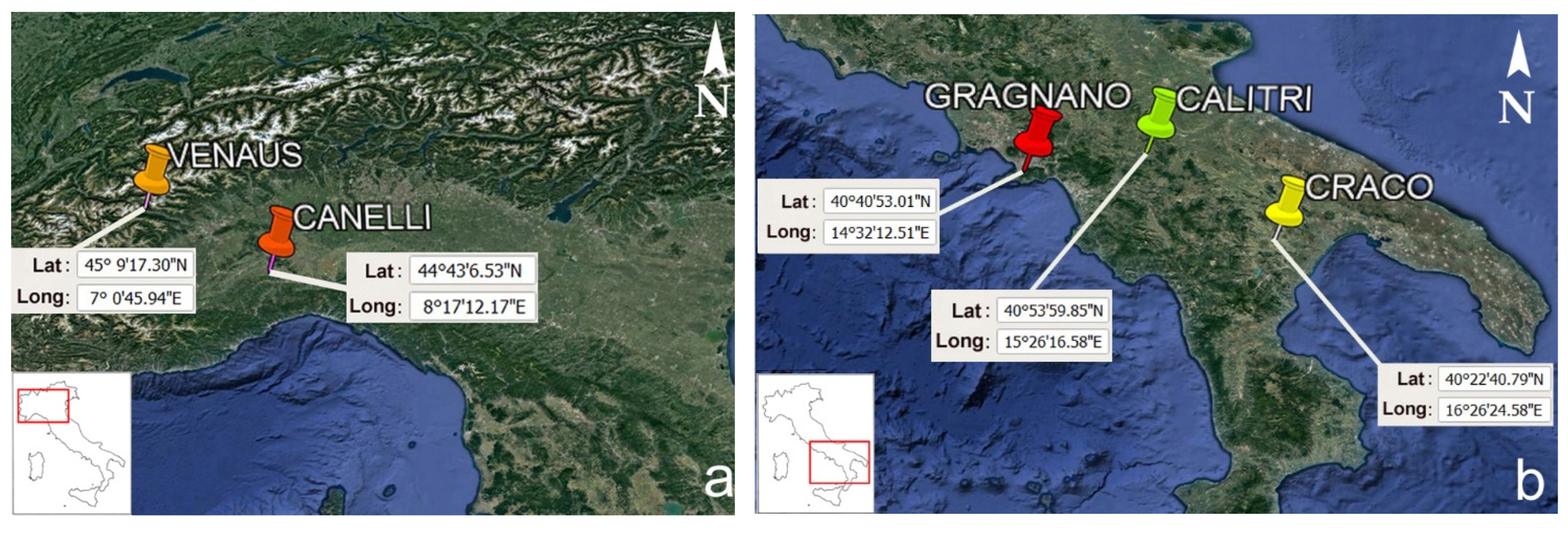
3.1. General Settings of the Case Studies

In the following subsections, five case studies in Italy concerning different geohydrological and geological hazards are investigated. All five towns or villages considered (Figure 2, Table 1) have been frequently hit by extreme natural events in the past, and we investigated such events, making extensive use of historical sources. Although the natural processes were repeated over time and many historical documents reflect the hazardous nature of these areas, no correct land use planning was adopted [94]. For each case study, both the research methodology and materials used, and the results obtained are discussed in depth.

3.2. Methods

According to Ibsen and Brunsden [129], historical data can be categorized into four groups: (a) data that directly report the occurrence of natural hazards (e.g., floods, landslides, earthquakes); (b) data that indirectly offer evidence that can support causal or explanatory models (e.g., climatic records); (c) auxiliary surveys that refer to other significant information (e.g., geomorphological surveys); and (d) phenological accounts concerning timing (e.g., changed groundwater levels after rainy periods).
The historical data we considered in our five case studies mainly belonged to groups (a) and (c). The data were used to identify the following: (1) the chronology of the triggers of natural hazards; (2) the features (e.g., magnitude, size) and causes of natural hazards; (3) the toll on human life (dead and wounded); (4) the damage to buildings, infrastructure, and cultural heritage; (5) the environmental consequences, such as primary and secondary effects of earthquakes; (6) the relationship between built-up areas and hazardous areas over time; (7) the transfer of urban areas due to the hazard; (8) consolidation works and their efficacy over time.
To shed light on these aspects, we carried out studies referring to documentary and ichnographic sources derived from (1) State archives, (2) historical archive of the National Department of Civil Protection, (3) municipal archives, and (4) archives of research institutes.
As regards the State archives, they are located in each provincial capital, with about 100 offices being scattered throughout the Italian peninsula. The role of these archives is to safeguard and make the most of documentary heritage and to ensure its public use. They conserve documentation produced by the central and peripheral administrations of the pre-unification states and the archives of the peripheral administrations of the unitary state [130]. In our study, we searched for and analyzed material related to documentation produced by Commissariato Civile per la Basilicata (CCB), preserved at the National State Archive of Potenza, the chief town of the Basilicata region. CCB was a body established by Basilicata Law No. 140 of 31 March 1904. It had a role in the planning and building of public infrastructure in Basilicata, including construction aimed at consolidating the towns affected by slope instability, in an attempt to mitigate the local geohydrological risk [131,132].
The second archive analyzed was Archivio Storico Nazionale del Dipartimento della Protezione Civile (National Historical Archive of the Civil Protection Department) in Rome. The documents were consulted before the historical archive was acquired by Archivio di Stato di Roma (State Archive of Rome). The collection amounts to about 15,000 documents related to disasters that have occurred in Italy since 1908. The archive grew thanks to several acquisitions from other bodies that were responsible for civil protection in Italy before the establishment of the Civil Protection Department of the Presidency of the Council of Ministers in 1982 [133].
The third archives we considered in our research were the municipal historical archives, the documents of which are recorded following a standardized methodology fixed toward the end of the century [134] by a circular by the Ministry of the Interior. These documents are categorized under 15 topics. Researchers interested in studying natural hazards usually focus their efforts on two main subject categories: X, Lavori Pubblici (Public Works), and XV, Pubblica Sicurezza (Public Safety). Research on the five case studies discussed in this article also focused on these two categories.
The fourth repository we analyzed was the historical archive of the IRPI-CNR. In particular, the historical archive of the IRPI of Turin contains over 120,000 unpublished documents concerning landslides and floods that have occurred in the basin of the Po River (the longest river in Italy) since 1800. For some areas, such as the Piedmont region, the available documents date back to the 1700s.
The documents largely consist of descriptive reports following technical inspections, declarations of public disasters, municipal resolutions, reports of instability and damage, field surveys, requests for subsidies, and so on. Much information on topics of interest is included in projects accompanied by floor plans, reports of direct testimonies, interviews, and black-and-white or color photographs. The collection of this documentary heritage was possible thanks to a long search carried out in numerous archives, such as state archives, prefectures, civil engineering offices, municipal archives, and archives of associations and private citizens. To safeguard the documents and make them available to researchers for faster consultation, they were all scanned and converted to Portable Document Format (PDF) files in 2011. Part of the documentation was also included in a relational database for the easier searching and consultation of historical records [135]. For the case studies analyzed in this article, we made extensive use of reports on the occurrence of natural hazards, descriptive reports on post-event inspections, municipal resolutions on remedial works to be carried out, descriptions by competent territorial authorities, maps of the affected areas, and photographs.
Beyond the original documentary records preserved in the public archives, we also considered printed sources, such as field surveys, monographic studies on natural hazards, historical cartography, local historiography, and newspapers. The latter were especially useful for identifying the chronology of natural phenomena and related damage.
In the analysis of natural phenomena and their impact on the built and natural environment, documentary sources from bodies with a public function (e.g., municipalities, civil engineering) were favored. These records usually guarantee higher quality and more complete information. Furthermore, to both ascertain the reliability of the information retrieved and ensure data completeness, we performed cross-correlation analysis on different historical sources. Overall, for the analysis of the five case studies presented here, the historical sources taken for reference span from the 17th to the 19th century. The next five sections describe, for each locality, specific aspects of the historical records used.

4. Results

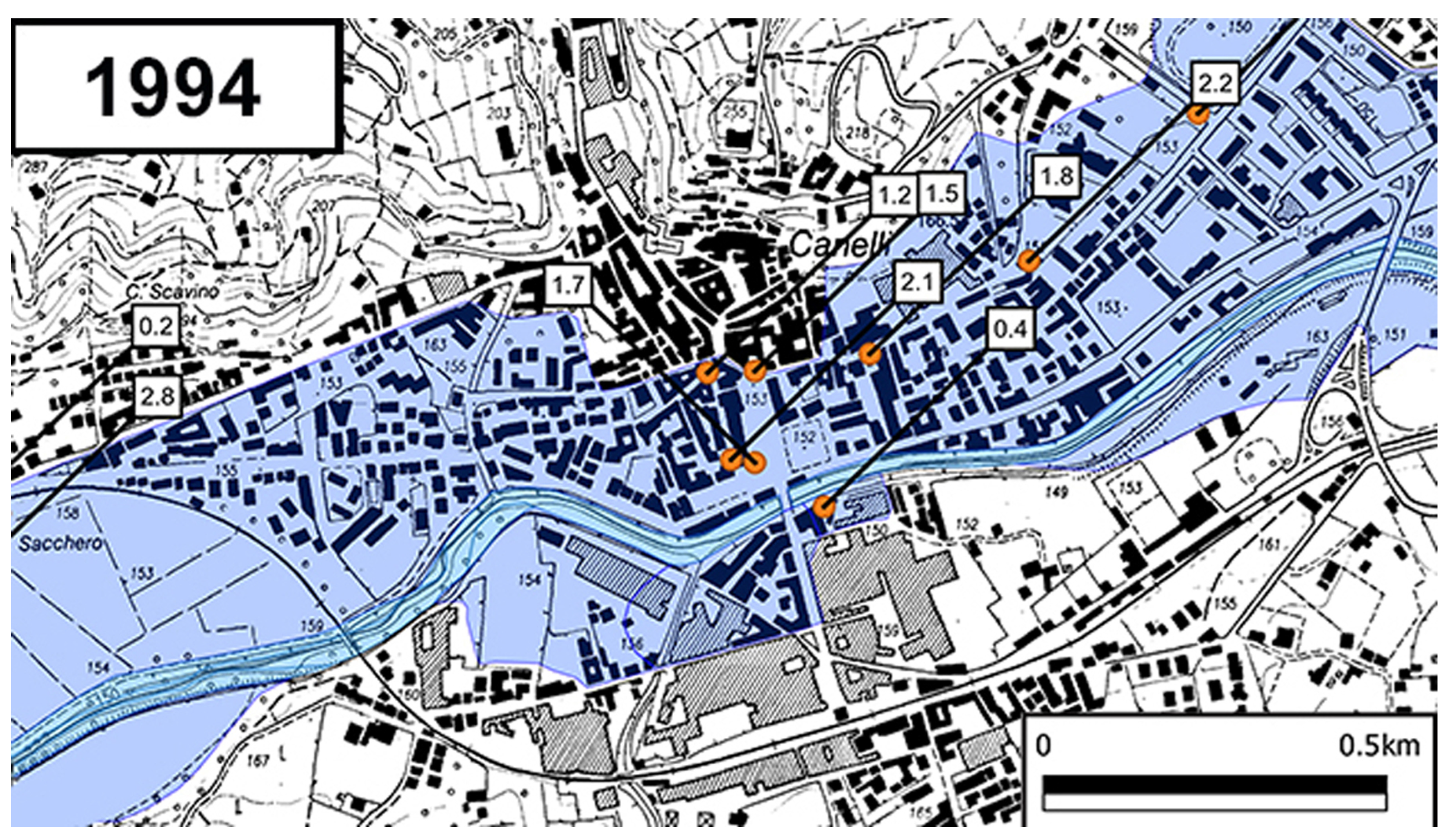
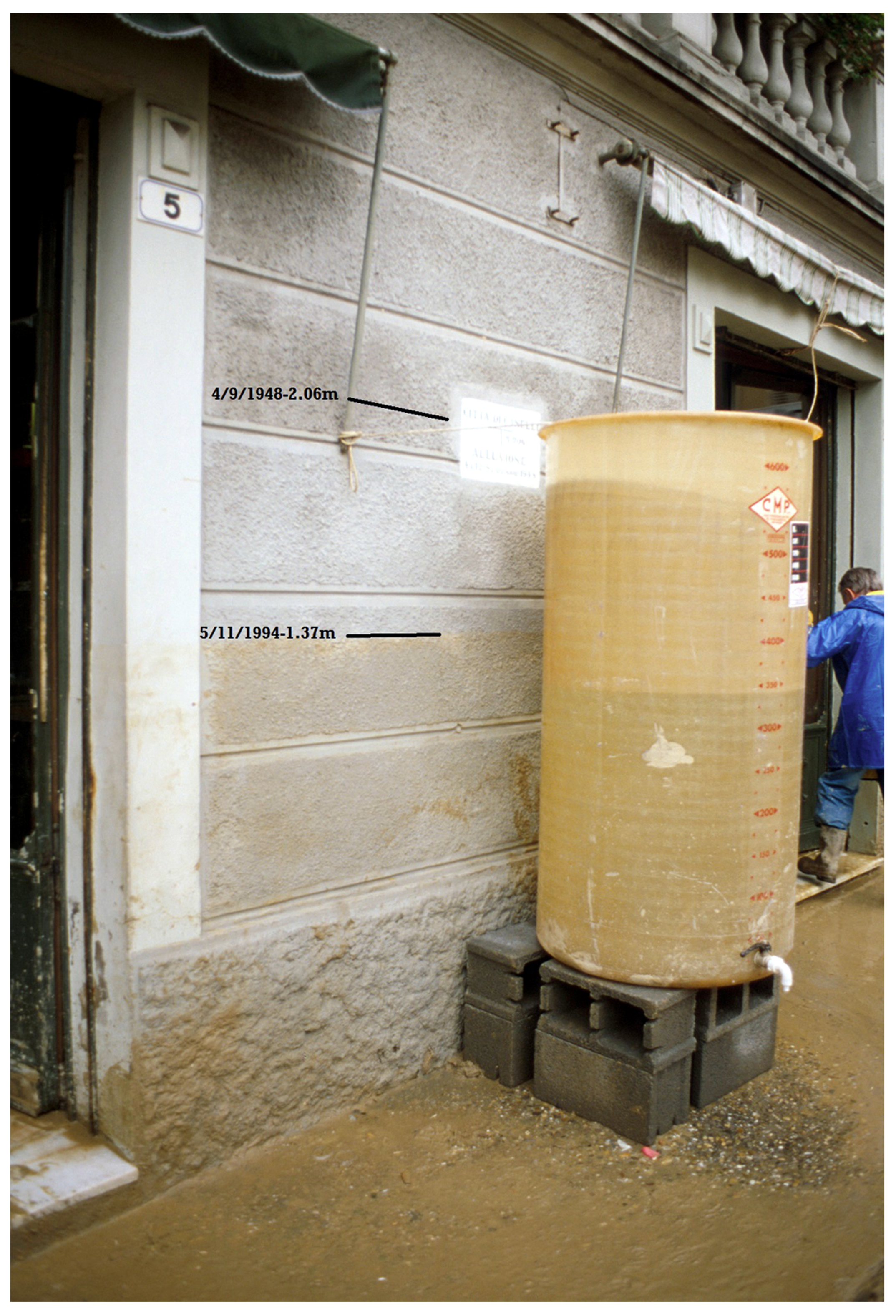
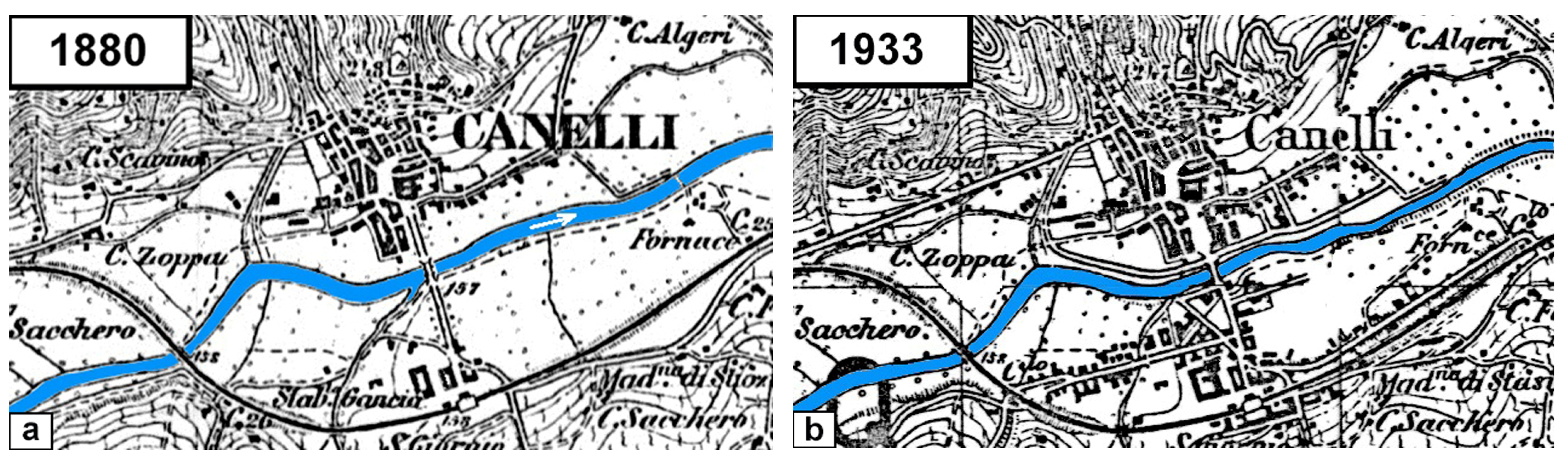
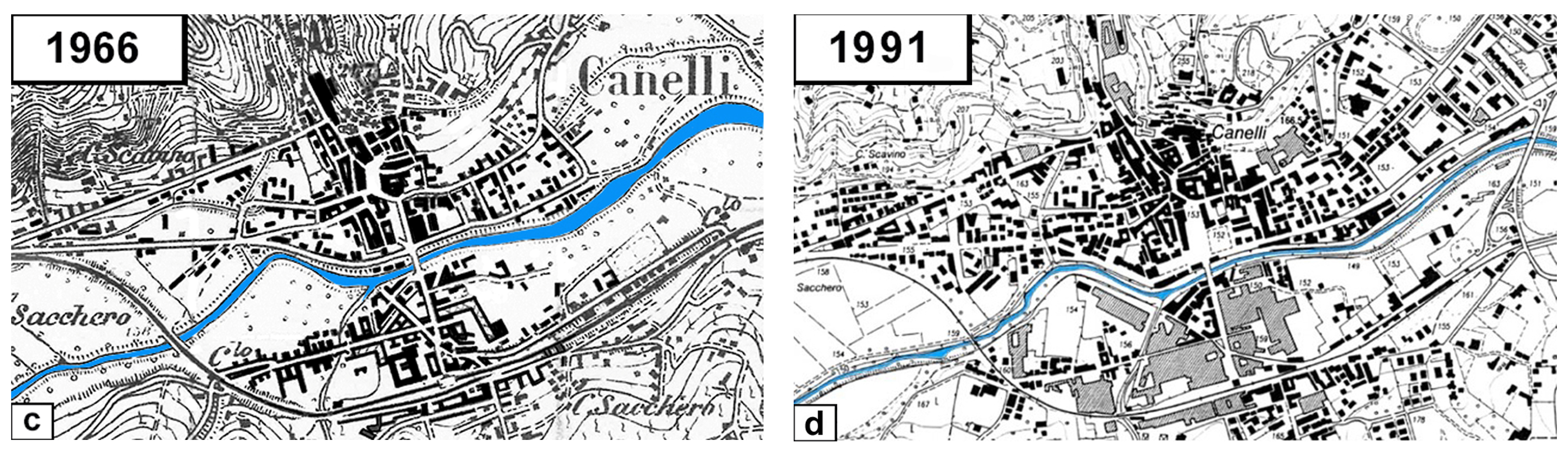
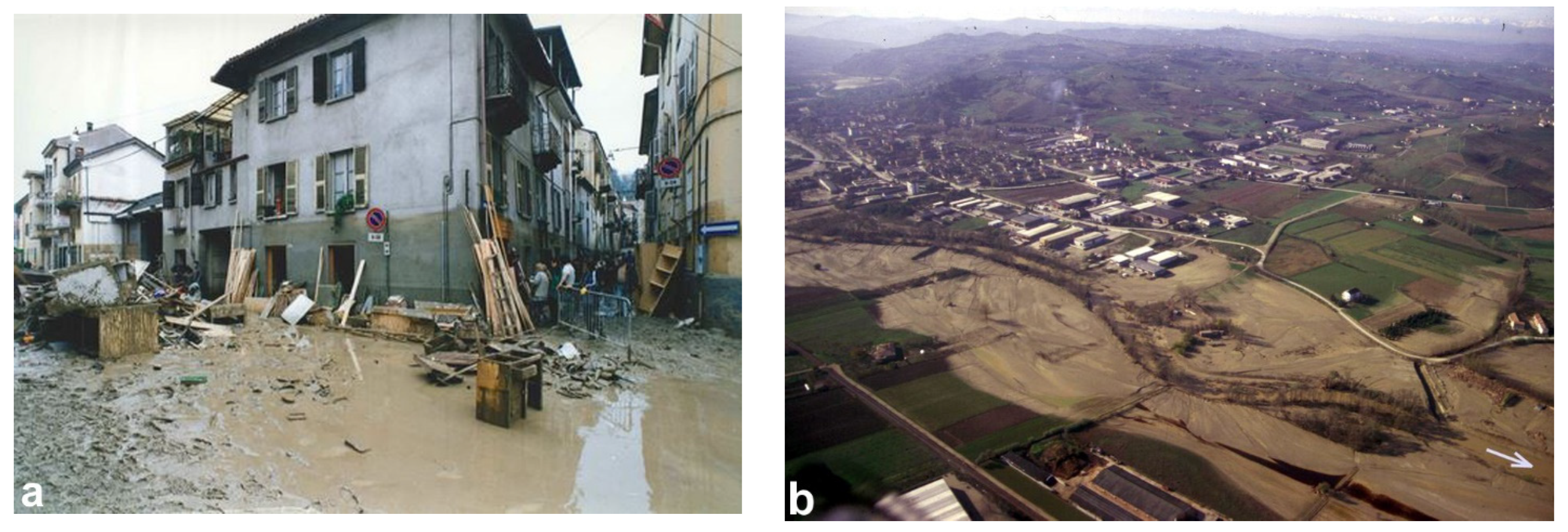
4.1. Belbo Stream and Its Floods in Canelli Town (Northwestern Italy)

Canelli town, with about 10,400 inhabitants, is located on the valley floor of the Belbo stream (Piedmont—Asti province), a right tributary of the Tanaro River, at an altitude of 155 m a.s.l.; the upper part extends over a hilly area that reaches up to 251 m.
The earliest historical information on flooding originated from the Belbo along the valley floor dates back to the mid-16th century [136]. The large municipal area of Canelli that borders the riverbed of the Belbo has been flooded several times; leaving aside the periods for which the information is incomplete and sometimes difficult to interpret, and considering only from 1800 to the present day, the concentric area turns out to have been inundated at least 17 times, 9 of which were particularly severe. The last disastrous flood occurred on 5 November 1994.
Like almost all inhabited centers, the old nucleus developed in the morphologically higher area, sufficiently distant from the riverbed, especially on the left slope of the Belbo. The valley bottom was still wide in 1852 [137]; the area belonging to the river was occupied exclusively by fields and pastures. The only historical additions were a road bridge that connected the two sides for centuries and the Alessandria–Bra railway, inaugurated in 1865, with the associated embankment and bridge upstream of the town. In 1880, on the right bank, the house closest to the watercourse was about 170 m away (Figure 3a) [138], while on the left bank, most of the houses along the main road were about 120 m from the riverbed, apart from two buildings that pushed toward the stream at a distance of about 50–60 m.
Two violent floods at the end of May 1879 and on 30 March 1892, with an overflowing of the Belbo stream, caused serious damage to the houses, small businesses, and workshops closest to the streambed. Over the years, the land on the valley floor that had remained vacant began to be occupied, mainly by craft workshops and houses. In the last years of the 1800s, the Piedmontese economy was transformed with the establishment of a system of large companies engaged in new types of production, such as the modern mechanical and electrical industry. Canelli, for example, became the headquarters of Gancia, a company internationally renowned for sparkling wines and vermouth. The Belbo valley floor gradually became more urbanized, so while the floods of the Belbo previously only involved the fields located on the valley floor, with the progress of urbanization, the first real problems began.
From 1880 to 1933, the town doubled in area from 1.08 to 2.16 km2 (Figure 3b) [139]. Businesses and homes began to appear on the right bank of the Belbo. In May 1926, a very serious flood occurred: over 100 houses in the capital were flooded, some up to a height of 2.5–3 m. There was serious damage not only to residential buildings but also to farmhouses, companies, craftsmen’s shops, and infrastructure. After the substantial post-flood interventions carried out along the banks and on the embankments by civil engineers, it would have been optimal to choose the areas farthest from the Belbo riverbed for buildings. Conversely, in the period between the two world wars, colonization of the territorial strip next to the riverbed of the Belbo continued at a rate of about 9 hectares per year. After a particularly rainy period, on 4 and 12 September, two very serious floods severely affected the economy of the little town. On 4 September, the Belbo stream flooded, overcame the banks, and invaded the whole concentric area on both banks, with heights exceeding 2 m. Several houses collapsed, and there was one casualty. In addition, in this case, the damage to commercial and industrial activities was serious, as many cattle drowned, the wells of the aqueduct were clogged, and telephone service and post offices were destroyed. Other infrastructure for public use suffered severe damage.
An exceptional flow rate of about 1100 m3/s was estimated for the Belbo stream. Only 8 days later, incredibly, another great flood occurred in the Belbo. The water invaded the town again and, although reaching a lower level (70 cm less than the level reached 8 days before), advanced with greater violence, causing greater damage than the previous flood. A total of 70 hectares were flooded [140]; in total, 18 houses were destroyed, and 97 were damaged. Damage was estimated at 1 billion and 300 million lire (equivalent to EUR 25 million today). The waters of the Belbo flooded the town again on 11 February 1951 [141] and 10 November 1951; on the latter occasion, the cost for restoring public works and repairing the damage to individual buildings was estimated at EUR 15.5 in today’s currency (“Report on the damage of the flood of 10 November 1951”). Despite these very serious events, the urban expansion of the town did not stop; rather, it continued. The built-up areas increased from 4.3 km2 in 1951 to 6 km2 in 1966, at a rate of 11 hectares per year. Historical research also includes two minor floods of the concentric area of Canelli on 10 April 1957 and 30 August 1968 caused by tributaries of the Belbo. However, nothing compared to the events of 2 November 1968. In Canelli, a torrential flood, with a flow of about 300 m3/s and a duration of 14 h, which was only partially contained within the previously built defense works, caused very serious damage. Occupying a large swath of the valley floor, 10 industrial, 170 artisanal, and 143 commercial companies were affected. The damage to public assets amounted to at least 380 million lire [142] or more than EUR 7 million today. Flooding originated from the Belbo also involved some side canals [140].
Massive works carried were out along the valley floor in the post-flood periods: robust walls, ripraps, and embankments were built upstream and in the concentric area. By the 1970s and 1980s, the last areas of the Belbo River still remained undeveloped. From 1966 to 1991 (Figure 3c,d) [143,144], the built-up area increased from 6.05 to 9.41 km2 at an annual rate of 13.4 hectares per year, greater than that during the period 1951–1966. In particular, upstream of the main bridge on the hydrographic right, just behind the riverbed, a large warehouse was built at the historic Gancia Winery, while on the left bank, several houses were built not far from the stream.
Figure 3. Historical reconstruction of Canelli’s urban development from historical maps: (a) 1880 [138], (b) 1933 [139], (c) 1966 [143], (d) 1991 [144]. The Belbo River is indicated in blue. North is up.
Land 12 01751 g003aLand 12 01751 g003b
In this urban situation, the great flood of 5 November 1994 occurred (Figure 4), the most serious in the city to date. The floodwaters of the Belbo broke through the railway embankment at the entrance of the town and poured into the town using the main artery as a means of outflow.
Witnesses reported that the water breaking through the railway embankment caused a sudden wave of more than 3 m (Figure 5a). Two inhabitants of buildings located near the breakthrough left their homes, were hit by the water, and drowned. There was also a third victim. The water transported and deposited sediments, floating material, and debris of all kinds in the inhabited areas. The embankment wall slowed the return of floodwaters into the riverbed. Despite the effects of gravity, in the central Piazza Cavour, a comparison of the height of traces left on buildings during the event and the level reported on a plaque referring to the flood of 4 September 1948 shows that the traces associated with the 1948 flood (2.06 m) are 69 cm higher than those from 1994 (1.37 m) (Figure 5b). It is true that the floodwaters in the town did not reach the historical heights of May 1926 and September 1948 (Figure 6), but on such a heavily urbanized valley floor, the damage was proportionally much greater.

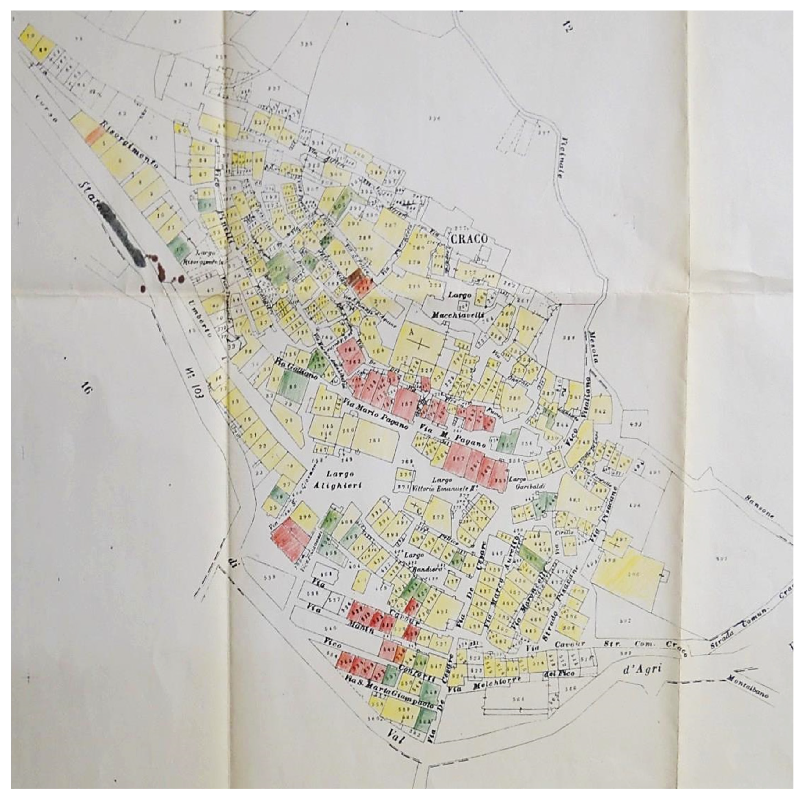
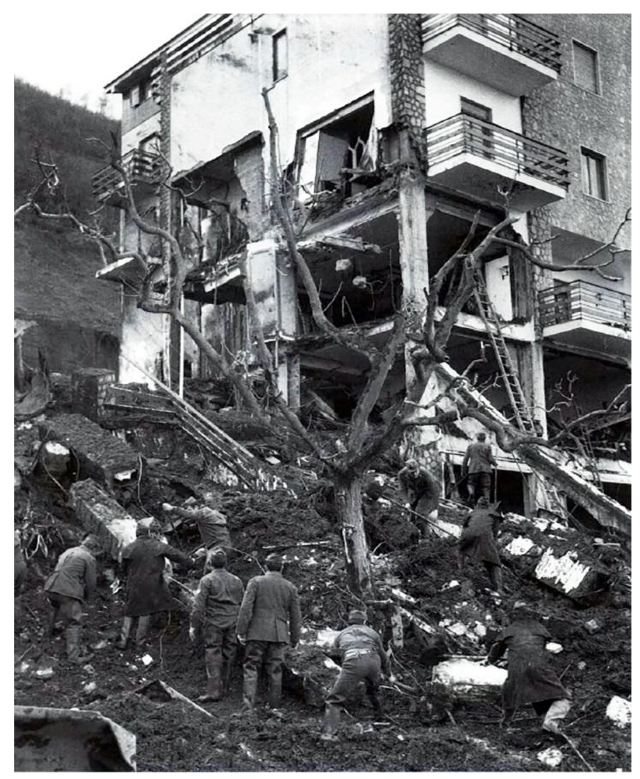
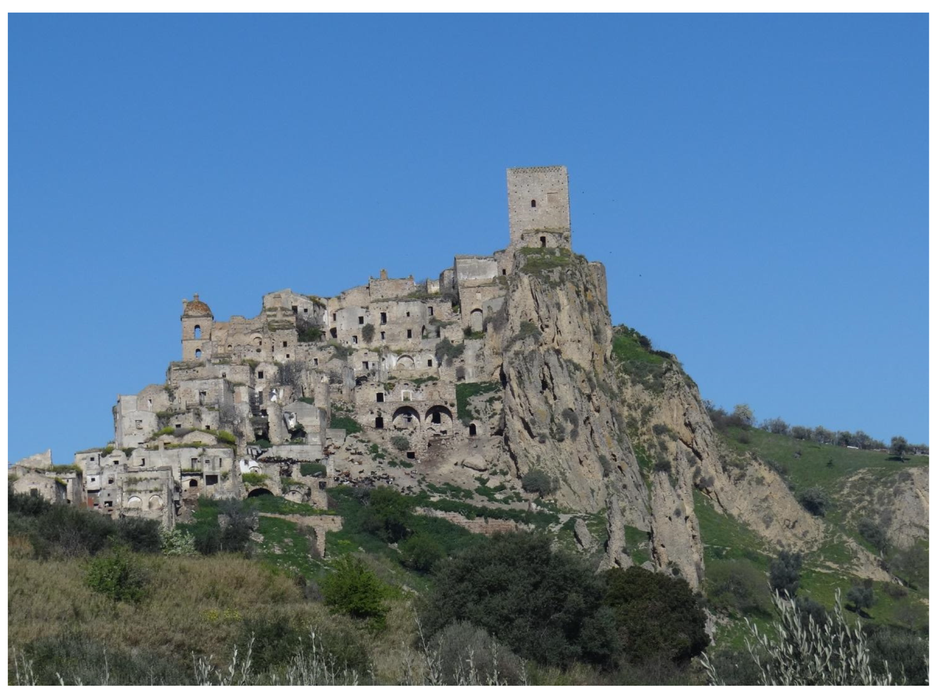
4.2. Forced Abandonment of Craco (Basilicata, Southern Italy)

The (abandoned) historical center of Craco (Figure 7) is in the Basilicata region (southern Italy). The region, which can be seen as an open-air laboratory for multidisciplinary and interdisciplinary research, is prone to earthquakes and landslides, which have affected towns and cultural heritage over time [145,146].
Craco, among the most famous and iconic “ghost towns” in Italy and the best known on an international scale, sits at about 390 m a.s.l. and extends over a NW-SE oriented ridge, delimited by two streams. Along the slopes of the ridge, allochthonous Cretaceous–Oligocene units are in contact with conglomerates, sands, and clays of Pliocene age. The northeastern slope of the ridge is affected by numerous landslides, some of which develop along the entire slope, up to the bottom of the valley. The southern slope is also marked by instability phenomena, including the Centro Storico (historic center; CS) and Convento (convent; CV) landslides, responsible for damage to buildings and infrastructure, with the subsequent transfer of the town [147].
The first notice regarding the activity of the CS landslide dates to the last decades of the 19th century, when a mass movement was recorded in the southern part of the town [148]. The reactivation of both the CS and CV landslides continued at different rates until the end of the 1940s. Following the landslides, several consolidation works were planned [149,150,151,152,153,154,155].
After a period of apparent inactivity, a football field was built on the body of the CS landslide, downstream of the state road surrounding the town [156]. However, the field was destroyed due to reactivation of the CS mass movement [156].
In December 1963 (Figure 8), both landslides reactivated, leading to the technical and administrative transfer procedures of the town [157,158]. The CS landslide reactivated again in January 1965, with partial collapse of the retaining wall built to support SS103 and significant damage to buildings (Figure 9). Because of the 1963 movements, after a field survey performed in early 1964, the technicians of the Italian Geological Service suggested transferring the town: “The phenomenon [landslide] is currently in such an advanced stage as to exclude any possibility of slope consolidation and, consequently, of consolidation of the town. Therefore, it is necessary to prepare the gradual transfer of the latter [Craco] to a more suitable area” (translated from Italian) [156].
Two possible areas were recommended: the first (Sant’Angelo) was close to the historical center, but with limited extension, and the second was located a few kilometers away (Peschiera) [156]. At first, the municipal administration approved the transfer of the town to the latter site. However, the identification of a transfer location changed in the following years. The technicians of the Geological Service carried out another field survey in June 1964 and suggested transferring the town to the site closer to the historical center [159]. This technical opinion was seen as supporting the widespread discontent among the population due to the socioeconomic disadvantages that would have resulted from transferring to the Peschiera site. Therefore, the municipal administration revoked the decision taken a few years earlier and ratified the Decree of the President of the Republic on 23 April 1965, No. 800, defining that the transfer should take place both at the site close to the historical center and at the site far from it [160].
Figure 8. Original map of damage caused by 1963 landslide reactivation in Craco historical center; effects were ascertained with coeval-to-landslide field surveys. Buildings that suffered lesioni forti (heavy cracks) are depicted in red; those that suffered lesioni notevoli (significant cracks), in green; and those that suffered lesioni lievi (slight cracks), in yellow [161]. North is up.
Land 12 01751 g008
Figure 9. Effects of CS landslide reactivation in Craco in January 1965. (a) Area close to the retaining wall, damaged and partially collapsed due to landslide movement; (b) same areas with damage to residential buildings in foreground. A counterfort sustaining a building can be seen, indirectly suggesting old movements of the landslide [162].
Land 12 01751 g009
From this depiction of the events, two observations can be made. The first remark is that the inhabitants and institutions did not consider the repeated mass movements, with the effects that they caused, as a “warning” sign; on the contrary, the areas affected by reactivation were, in some cases, subject to reconstruction. Furthermore, the urban expansion of Craco toward the southern areas of the relief continued in the 19th and 20th centuries even if the retroactive nature of the CS landslide should have advised against this choice. In fact, the urban development of the historic center of Craco can be divided into three main phases [147,163]: (1) the first settlement nucleus (11th–14th centuries), which developed around the Norman Tower; (2) the expansion phase between the 15th and 18th centuries; and (3) the expansion phase that can be dated between the 19th and 20th centuries, a period during which landslide phenomena (in particular CS), despite having largely shown signs of their activity, did not discourage urban development in areas at risk.
The second observation is that, in most cases, the consolidation works were designed and carried out only after the landslide had occurred, thus highlighting the lack of resolute institutional action aimed at preparing an organic plan to try to mitigate the hydrogeological risk in “peacetime” (prior to paroxysmal phenomena). Furthermore, some superficial infrastructure interventions were carried out by technicians and/or workers, such as the construction of retaining walls at the end of the 19th century and a sports field on the landslide body, which certainly contributed to the reactivation of the CS landslide in the late 1950s. There was also no close convergence of actions between national and local bodies to coordinate an organic plan for risk mitigation. Additionally, some of the preventive actions were met with resistance by the inhabitants, who were reluctant to follow the ordinances (e.g., closing of the tanks), thus making efforts to reduce risk somewhat useless.
All of this must be added to the lack of in-depth knowledge of the characteristics of mass movements (particularly the CS landslide), such as the depth of the sliding surface. These considerations can make us hypothesize that the settlement did not acquire resilience over time but gradually lost it, thus facilitating the decision to transfer. As for the latter, during the initial phase (mid-1960s), there was a divergence between the topographical and geological requirements of the new site, favored by the municipal administration, and the socioeconomic ones, claimed by the inhabitants. Therefore, the area initially selected for the transfer was considered inadequate by some of the citizens who were worried about the economic impact on their families. Later, the local government accommodated the citizens’ needs and supported the transfer of Craco to two places at different distances from the unstable village. This change in policy, certainly dictated by political opportunity, was also conditioned by two socioeconomic ideas about the development of the area. The first idea was focused on a paradigm shift in the economic perspective of the inhabitants of Craco to select a place (Peschiera) closer to a developing industrial area (areas of Pisticci and Val Basento), while the second idea considered the historical rural disposition of the inhabitants who emphatically rejected this paradigm shift and vigorously asked for a new settlement closer to the location of the owned land. Obviously, the change in perspective affected the timing and planning of the town transfer.

4.3. Gragnano Debris Flows (Naples District)

Gragnano, in the district of Naples, is almost entirely surrounded by carbonate reliefs that form the first branches of Monti Lattari. This is a geologically unstable area because of its pyroclastic deposits from millennial eruptions of nearby Vesuvius. Fast mudflows in pyroclastites (or, better, volcaniclastic debris flows) from Mount Pendolo have occurred in this area. In Italian, “pendolo” means “pendulum”; it is a toponym that, as has been remarked, “says it all because of its swings once to Pimonte and again, but mostly, toward Gragnano” (translated from Italian) [164].
On 21 January 1841, a debris flow from Mount Pendolo, at that time also known as Mount Suppezza, devastated the crops, ruined some houses, and killed three people. During the night, after two more victimless landslides, a catastrophic mudflow battered “rione Trivoncello”, destroyed houses, and buried 103 people. Among them, only 6 were taken out of the rubble alive, although 1 girl did not survive, so the overall number of deaths was 101.
As is often the case with great catastrophes, especially very ancient ones, there is no agreement on the figures; some sources at that time spoke instead of 113 victims. Despite the limited geological knowledge available at the time—the reports and descriptions of hydrogeological instabilities were provided by people other than geologists—at least one contemporary author shows an indisputable awareness of the causes of the phenomenon. Camillo Ranieri wrote that the mountains above Gragnano (Figure 10) are “of calcareous spar mixed with calcium carbonate. The Vesuvius eruptions have blanketed them of layers of lapilli […]. The heavy rains, especially last January, saturated those soils and lapilli that had abundantly accumulated on limestone rock, and because they could not penetrate into the bowels of the mountain, all materials which blanketed them lost balance: they fell precipitously down for both steepness of the mountain, and enormous weight in comparison with volume, and, overcoming all obstacles, crashed many houses which were unstable and not newly built” (translated from Italian) [165].
Ranieri’s final reflections are based on strong pessimism regarding the geologic stability of that area: “further rains could do repeat the disasters”, he wrote. This is a cautionary tale that came about with awareness of the weakness of those slopes, an admonition that—as often happens with the permanent loss of historical memory of previous disasters—was unable to create widespread awareness, through collective consciousness, of avoiding, especially in the following century, the anthropization of land with a high degree of risk.
It should be remembered, however, that not all historical sources agreed that the catastrophic event was a pyroclastic flow. Geological science still took a pioneering approach in Southern Italy in the 19th century, thus, in an article published at the same time, another architect [166] questioned this point of view. His argument was that the main cause of that crash was determined to be some unspecified “electrical currents coming from the depths of the mountain”; therefore, his conclusion was that there would be no risk in the future.
The catastrophic magnitude of that event could not but leave a mark, and in fact, other writers, in the following decades, pieced together the event scenario [167,168,169,170,171]; at the beginning of the next century, Roberto Almagià [60], the author of a famous treaty on landslides in Italy, recalled that tragedy. However, all these publications and all these witnesses were unable to settle, in the collective consciousness, awareness of the high-risk level of that territory.
To confirm the high-risk level of that area, it should be noted that most of the historical sources above, in addition to the event of 21 January 1841, mentioned a previous episode, the debris flow of 20 January 1764, which destroyed “Rione Bagnulo” in the same municipality, causing the death of 42 people.
More recently, similar events have been reported in scientific work, especially after a similar phenomenon occurred in the neighboring Sarno in May 1998, killing 160 people. The clamor after that disaster was an incentive for carrying out new research to provide a complete picture of debris flows in Campania over the centuries [87,172,173,174]. These new studies identified another event like what occurred at Mount Pendolo as long ago as October 1540, in the locality of Congiaria. In contemporary times, further debris flows occurred on 20 August 1935, on the east side of the village (contrada Tavernarola), and on 17 February 1963, destroying a farmhouse and burying four people.
Despite this centuries-old sequence of events, and despite the evident risk exposure, the period that began after World War II, under the pressure of significant demographic growth, appears to be characterized by a sort of collective removal of the problem. Gragnano’s urban development proceeded in a confused way: wild anthropization characterized by new settlements, usually built with little attention to the geolithological balance of the land. The most emblematic event occurred on 2 January 1971: Upstream of the hotel La Selva, built a few years earlier in a zone exposed to landslide risk, an excavation was carried out to build a house (Figure 11) [175]. After two days of torrential rain, a 7000 m3 mudflow collapsed from the altered hillside and destroyed the hotel and four houses. Six people died, and a wedding procession headed to the hotel was almost involved. But this was not the final event: other mudflows, although much smaller, occurred, including one in February 1987 on a highway and one on 11 January 1997, which destroyed a stable and killed livestock.

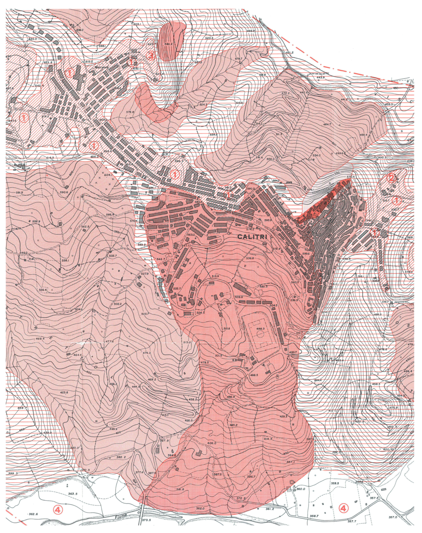
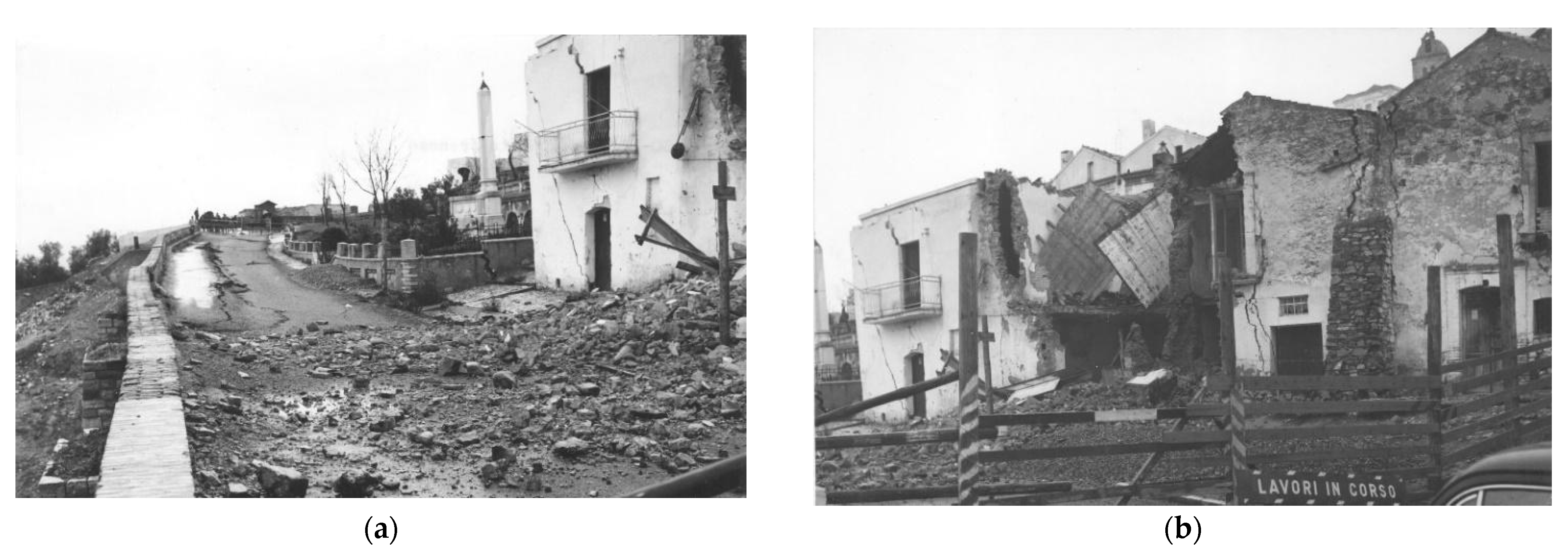
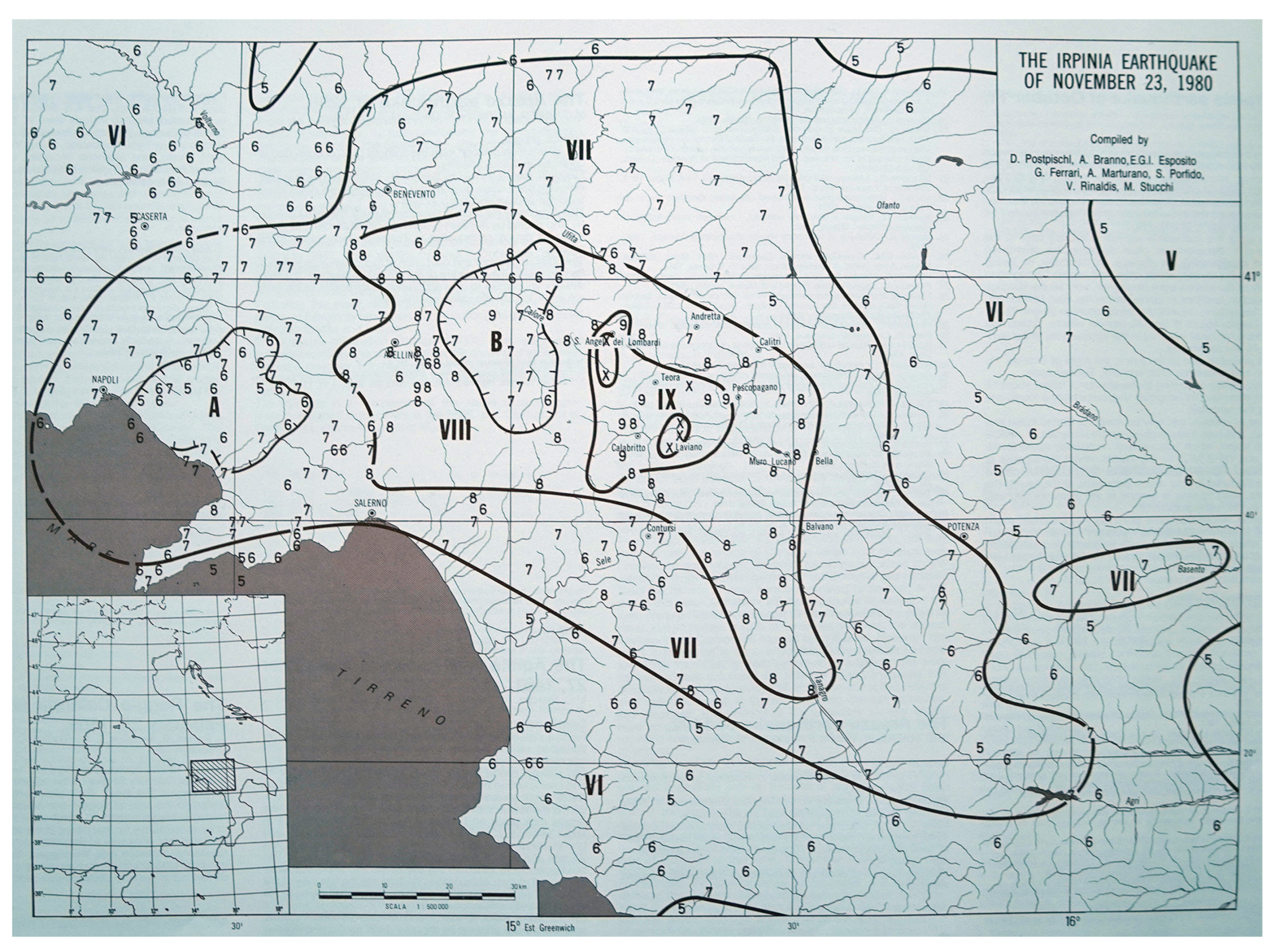
4.4. The Memory of Earthquake-Induced Instability in Calitri

The backwards history can start from the last strong seismic event, which struck Southern Italy on 23 November 1980 (Mw 6.9; Io = X MCS) (Figure 12 and Figure 13). The earthquake caused serious damage in almost 800 localities; a total of 75,000 houses were destroyed, and 275,000 were severely damaged. About 3000 people were killed, and 10,000, injured. Fifteen municipalities throughout the Avellino, Salerno, and Potenza provinces were nearly totally destroyed with MCS/MSK level I ≥ IX intensity (Figure 12) [13].
The effects on the natural environment were also devastating, including primary effects such as superficial faults and secondary effects (sensu Michetti et al., 2007) [176] such as landslides (200 were identified), fractures in the soil, hydrological variations, and liquefaction phenomena [177,178].
Calitri, a small village with about 5000 inhabitants in the hinterland of Irpinia in the southern Apennines (Campania region) suffered VIII MCS/MSK and ESI-07 level damage [13,178,179], with six fatalities (Figure 13).
In addition to the damage to buildings, there were multiple environmental effects, such as liquefaction phenomena, ground fractures, and significant gravitational phenomena [177,180,181]. Among the latter, particularly devastating was the extensive landslide movement, approximately 850 m long and about 100 m deep, classified as slump-earth flow, which mobilized 23 million m3 of land, with destructive consequences for the houses in the historic center [180,182,183,184].
Similar to what happened after the 1980 earthquake (Figure 14), the village had already been affected in the past by sliding phenomena triggered by earthquakes that occurred in 1694, 1805, 1851, 1910, and 1930 in the southern Apennines [179,185,186].
Figure 13. Seismic microzonation map of Calitri drawn by Samuelli-Ferretti and Siro [180] for the PFG-CNR immediately after the November 1980 earthquake. “① very good foundation soils; ② moderate foundation soils; ③ bad foundation soils; ④ flat areas with increases in seismic coefficients” North is up.
Land 12 01751 g013
To understand the evolution of today’s landslides, we also need to study what happened in the past, particularly the landslides induced by past earthquakes. Essential to the reconstruction of the process of landslides triggered by earthquakes is appropriately choosing historical documentation contemporary to the seismic events examined. We propose, as an example, significant extracts from original sources related to two strong earthquakes in the southern Apennines: one on 8 September 1694 (epicentral area between the Campania and Basilicata regions: Lat 40.862 Long 15.406) and one on 26 July 1805 (epicentral area in the Molise region: Lat 41.500 Long 14.474). Historical documents are of fundamental importance because they highlight the level of damage not only in the center but also in the surrounding territory, areas that over time could constitute expansion zones to be kept under proper control before being used. After the earthquake of 1694, Calitri, located in the epicenter, was almost completely destroyed, reaching X MCS, with the loss of at least 311 people, as shown by the parish documents of the time (other historical sources report between 700 and 1200 victims).
The earthquake also triggered a landslide phenomenon, which developed from the top of the village, where a castle was located. The movement was characterized by “two very large, very wide, deep openings” (translated from Italian), as an anonymous source of the time described. “At 8… of the fallen September 1694 at about a quarter to 6 p.m. of the Italian clock, … a frightful earthquake made itself felt, shaking the earth for the space of a Creed… The village of Calitri, it is all destroyed, with the churches, houses, and monasteries. The castle of Calitri, situated above a very large mountain in the manner of a fortress, with bridges, which opened on one side, and fell over the soil, which was below them… In the castle of Calitri, in the two courtyards, two very large openings were made very wide and deep, which make it a great surprise, calculated to be in this village perished about 700 people” (translated from Italian) [188].
The second description refers to the 26 July 1805 earthquake, which mainly devastated the Molise region (Io = XI MCS), with also considerable damage in the Campania region [177,189]. Even though Calitri was located far away, more than 100 km from the epicenter, it experienced the triggering of a large landslide movement, as reported by naturalist physicist G. S. Poli [190]:
“In Calitri’s land… on the way to Castiglione, a large piece of land was turned upside down, and in the act of trembling, flames were seen coming out of it… The trees, which had been planted there, sank into the ground as a sign that now you can barely see the tops; and a rustic pagliajo [pile of straw] was completely absorbed in it. The fracture then occurred one mile away from the said land, starting from the Vallone de’ Monaci up to the place called the Mountains, extending from East to West for the length of one mile, having the width of five palms. Here, also the land has been furiously upset and undermined, partly absorbed oak trees and almond trees and olive trees, and partly covered and buried them in the same way, which can no longer be seen” (translated from Italian).
The history of Apennine villages such as Calitri is often very complex, since in addition to the natural socioeconomic factors governing development, the role of natural hazards in the territory must also be appropriately considered. In this case, not only hydrogeological instability but also seismic phenomena have played a significant and in some cases even predominant role, and together, they have caused severe damage in the urban context, constrained development, and caused damage to the surrounding natural environment.
Hydrogeological upheaval and seismic hazards can, at times, merge. We must not forget that earthquakes with sometimes very distant epicenters have triggered considerable landslides both within and outside urban centers, which are certainly not negligible contributions to the modification of cultural heritage. Similarly to what happened after the 1980 earthquake, the village of Calitri had already been affected by complex sliding phenomena triggered by earthquakes that occurred in 1694, 1805, 1851, 1910, and 1930.
This is why, when planning the future development of villages, it is desirable to never neglect the historical memory of what happened many centuries ago, which has been passed on to us by detailed historical sources, chronicles, letters, etc. A reading of the recent past can help us understand how much these phenomena have affected people’s capacity for resilience and thus their attachment to the territory, even if not always under optimal conditions. Therefore, historical information should represent a systematic approach to obtaining a rich database for the overall assessment of the territorial risk of any technical intervention. This is certainly an important approach, the results of which, in all their complexity, should be provided by administrations to the population as a starting point for responsible and knowledgeable territorial planning.

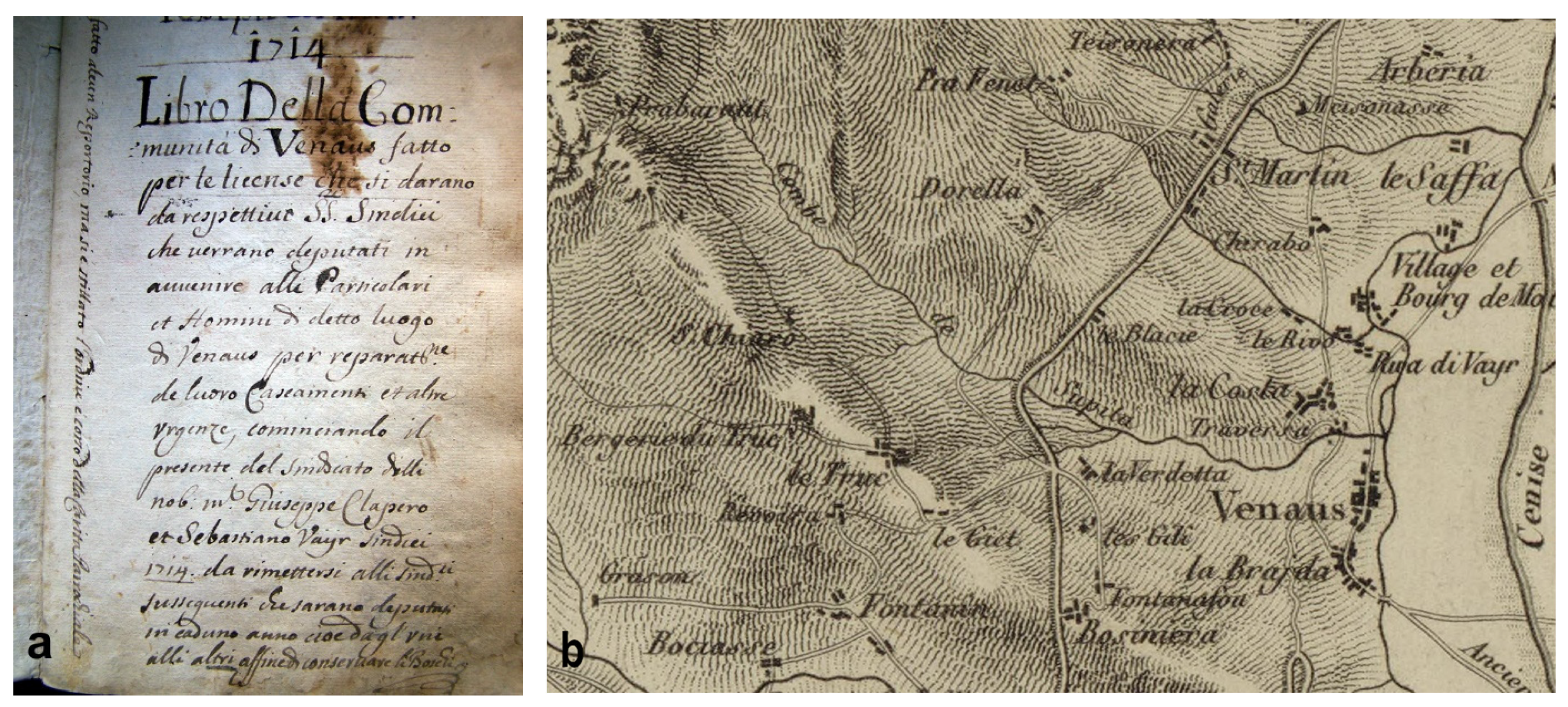
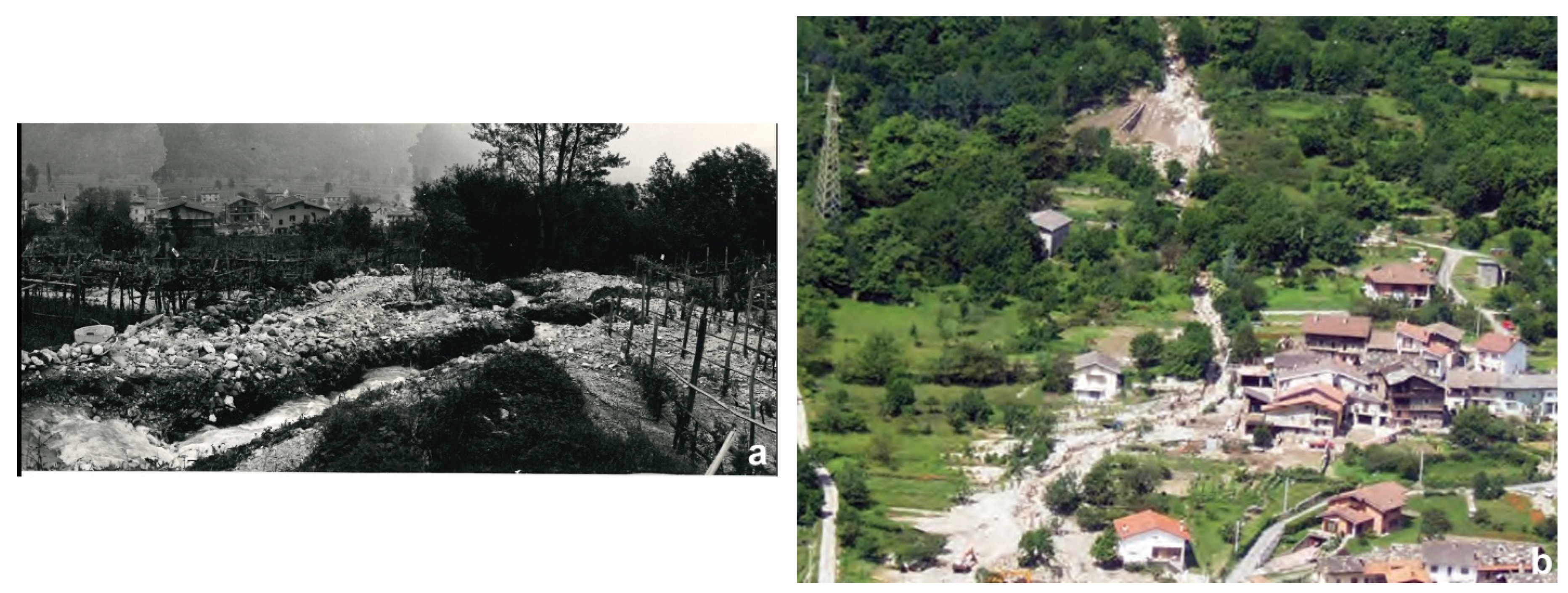
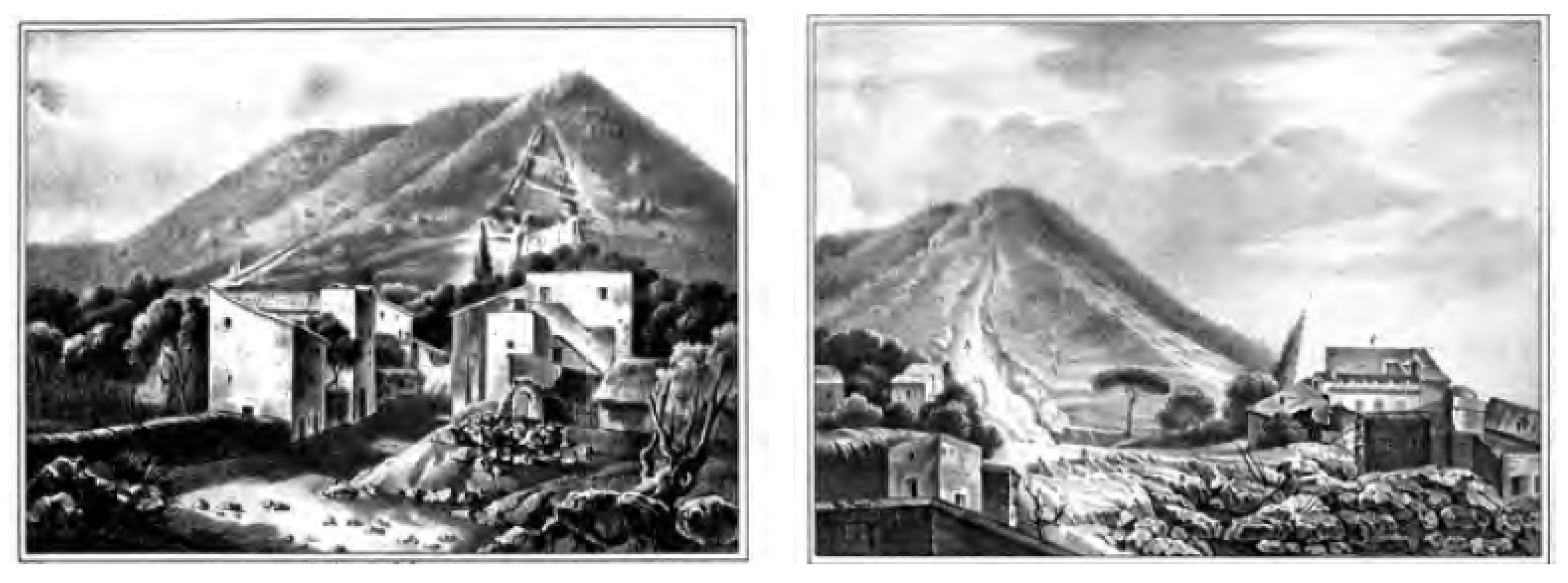
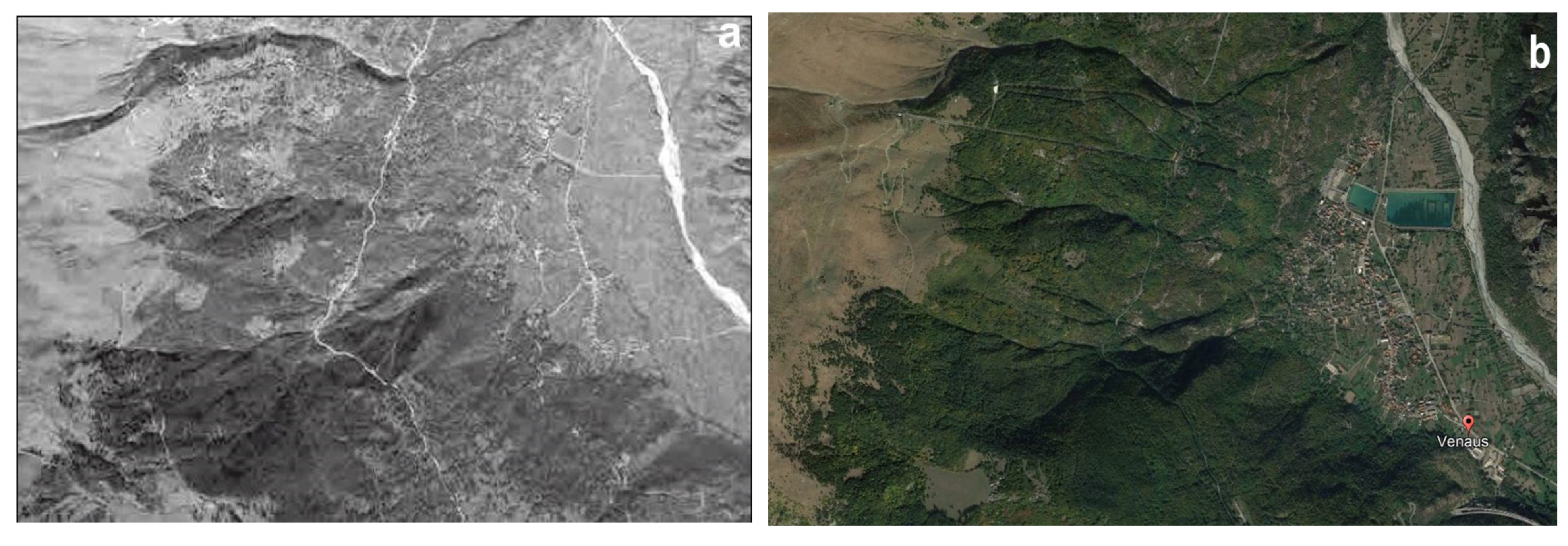
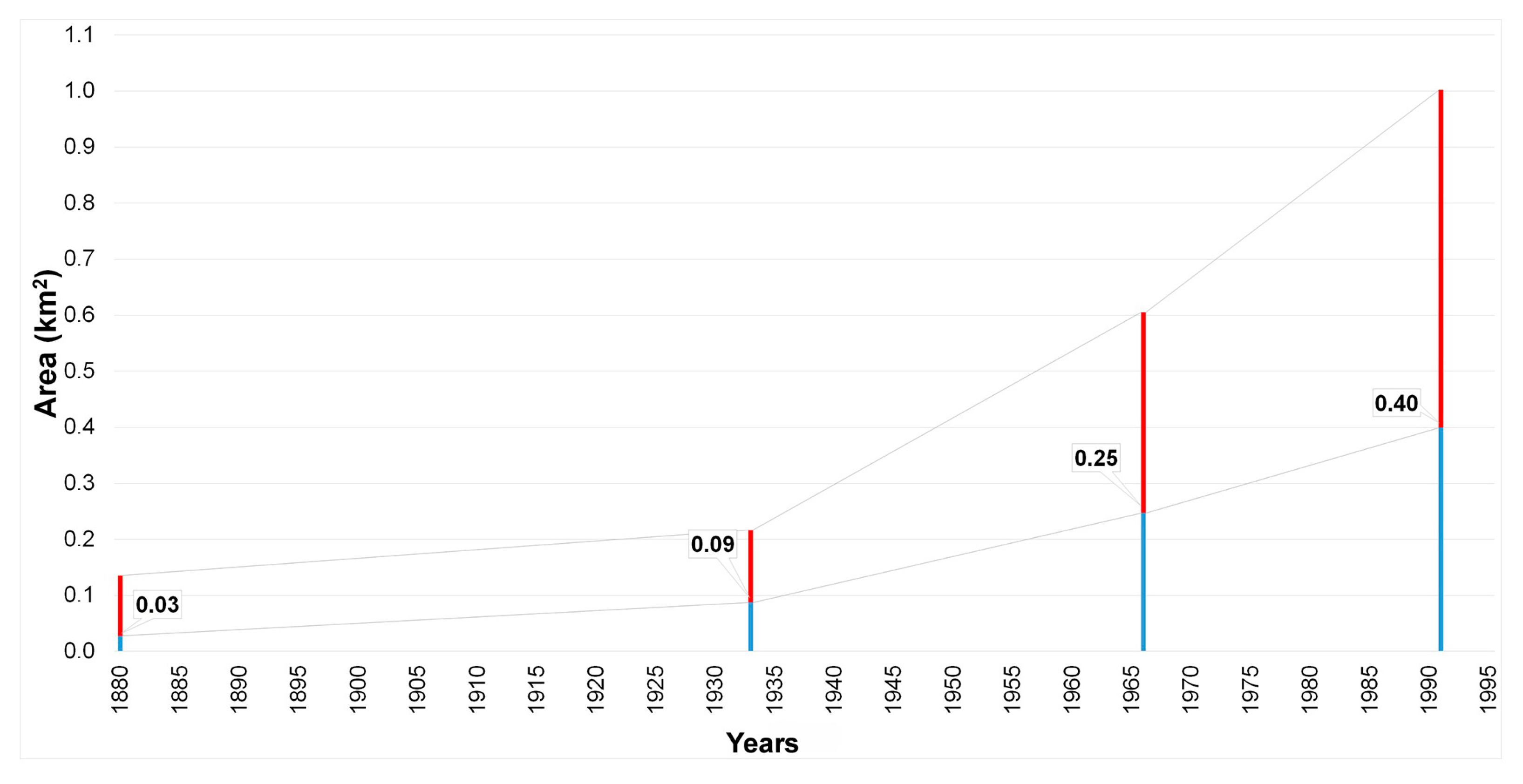
4.5. Debris Flows on Supita Alluvial Fan (Venaus—Turin)

There are hundreds of historical reports that describe mud–debris flows causing casualties and damage in the alpine basins [93,191]. Often, the predisposing factors are acclivity, debris cover, fractured bedrock, and the presence of unstable boulders along the banks and slopes [192]. The case presented here represents one of many [193] in which the elements of geomorphological and hydraulic risk are merged.
The catchment area of the Supita stream, the right tributary of the Cenischia stream in the middle of the Susa Valley (municipality of Venaus, about 80 km west of Turin), has an average slope of 62% and an area of 2.2 km2, and it develops for about 4.2 km, with an altimetric excursion of over 1500 m between the closing point (720 m) and the highest peak of the watershed ridge (2320 m) located in the northwestern end of the header watershed.
In the terminal section of the basin, the accumulation of debris with significant volume can quickly reach the apex of the alluvial fan due to mud–debris flows [194,195]. The watercourse near the inhabited center flows channeled up to the closing section at the confluence with the Cenischia stream. The distal part of the large fan is blurred with the extensive Cenischia alluvial plain. This includes other contributing factors that recurrently behave similarly to those described and on which there has been detailed research [82,196,197,198,199]. The high level of anthropization in the distal and central sections of the Supita alluvial fan obliterates the morphological evidence of torrential dynamics, except for the area close to the apex.
In this area, it is still possible to recognize some secondary channels and elongated lobed shapes parallel to the banks [200]. The “defensive” system is tied to the conformation of the inhabited core, where dedicated spaces for the watercourse are extremely small and undergo alternating mud–debris flows and avalanches [201].
Thanks to the cartographic and iconographic heritage (Figure 15, Figure 16 and Figure 17), the historical analysis made it possible to identify numerous previous events of debris flow and slope instability that affected the territory of Venaus.
The main paroxysmal geohydrological and morphological instability events documented for the Supita basin are listed in chronological form in Table 2. In addition to the episodes of debris flow and torrential floods, there are those related to avalanche activity, which historically occurred with high frequency. The SIVA catalogue and the Web GIS of ARPA Piemonte report 11 avalanches that occurred between 1845 and 2020, only 6 of which caused damage.

5. Discussion

The five cases presented in this paper cover the most widespread geological and geomorphological phenomena in the Italian peninsula: floods, landslides, debris flows, and earthquakes. All cases provide evidence showing how events that occurred repeatedly in the same places over time were not appropriately considered in land use planning; we could dramatically state that history has taught nothing.
Take, for example, the case of Canelli, a classic town located near a waterway on the valley floor that has expanded over the decades despite recurring floods (average of one flood every 24 years for the past 160 years) sending unmistakable signals about where not to build. In addition, despite the damage caused by floods, the city administration continued to shortsightedly grant building permits in areas that had been flooded. It always relied on expensive river works that were carried out in post-flood months; unfortunately, for citizens, such works always create an extremely dangerous false sense of security. In Canelli, after the last very serious flood occurred in 1994, a water retention basin was built upstream of the town, with an area of 39 hectares; it is expected to mitigate but certainly not drastically reduce problems associated with future flooding. If the municipal administration had practiced good urban planning over the decades, could the recent floods, and particularly the 1994 flood, have caused less damage? In other words, if they had not built new buildings in the areas closest to the Belbo riverbed and in the most morphologically depressed areas, could much damage have been avoided? Historical mapping and data from retrospective research were used to answer this simple question. By superimposing the inundated area on the Belbo valley floor in November 1994 over the oldest maps, it can be seen that it increased from 0.03 km2 hypothetically inundated in 1880 (20.35% of the total urbanized area) to 0.09 km2 in 1933 (40.35%), 0.25 km2 in 1966 (40.86%), and up to 0.40 km2 in 1994 (39.86%) (Figure 18). Since the proportion remained practically the same from 1933 to 1994, we can say that during this period of construction in Canelli, almost every second building was located in a potentially flood-prone area, despite the repeated severe flooding in the town during the same period.
Canelli is a typical small Italian town located on a valley floor where the acquisition of pertinent riverine areas, not supported by adequate basic knowledge, has inevitably led to the suffering from the effects of river activity, with consequences that are all the more catastrophic the more they are unforeseen. While under ordinary conditions, hydraulic defense works can guarantee a good level of safety, because they can control river processes and limit their effects, it is primarily during extreme events that the rapidity and violence of these processes often disrupt the implemented interventions, leaving the population completely unprepared. A clear example of this is the catastrophic flood of November 1994 in the Canelli area.
There have been erroneous land planning choices dictated by the local administrators’ need to acquire new land to be urbanized without ascertaining its hazards in advance, despite the rich historical documentation available for such an assessment being evident. Above all, they almost never turn to river geomorphologists, only to hydraulic engineers, who have a softer and more tolerant approach to the problem of land loss. Particularly surprising is the obstinacy and obtuseness of administrators who continue to build in areas that were repeatedly flooded in the past, trusting in mitigation works, as well as fate and in the welfare state. The proposed investigation methodology, applied to the Canelli territory and adaptable to other territorial situations, is based on consultation of historical documentation, consisting of bibliographic, cartographic, and archival material; it represents a first basic approach to gathering the knowledge of areas exposed to flood risk but should be integrated with geomorphological investigation and hydraulic verification for a more precise delimitation of areas that could be flooded following a reference flood [208].
Also interesting is the case of Craco, in Basilicata. From a methodological point of view, two main deductions can be made from this case study. First, the results of the research underline the importance of extensive, in-depth, cross-correlated historical investigation. This is useful to identify both the sequence of occurrence of landslides, and their effects on the built environment and the actions implemented by institutions. In this case, examining historical sources helped to show the weaknesses in the management of the risk chain. In this view, a retrospective analysis can be useful to identify possible actions to be taken to increase the resilience of small settlements and improve the decisions regarding their fate (transfer or in situ reconstruction) in case of disasters triggered by natural hazards.
Regarding risk management, the study highlights the need for close synergy between central and local institutions. Furthermore, the research suggests actively involving the population by making people aware of territorial risks and stimulating the use of adaptation strategies. Regarding post-event management and the possible transfer of inhabited areas subject to natural hazard risk, conducting an in-depth socioeconomic analysis of the territory is essential, as well as considering the old, hazard-affected settlements as places where the identity of local communities is strongly rooted. Furthermore, there should be an emphasis on the valorization and rehabilitation of “ghost towns” throughout Italy. In-depth studies would increase our knowledge of such places, as a preliminary phase in their valorization. In fact, Craco, along with other towns abandoned after extreme natural events, can be considered an open-air laboratory through which the population, especially young generations, can be informed about natural and geological risks of the territory in which they live.
As for Gragnano, historical research has shown the occurrence of numerous landslide events since ancient times. The pyroclastic coverings deposited on the surrounding mountains as a result of the eruptions of nearby Vesuvius have always made the area particularly fragile. Rapid flows of loose pyroclastites, which are often triggered by violent rainfall events, are widespread throughout the vast area surrounding Vesuvius. The inhabitants of that area remember what happened in nearby Sarno, where, on 5 May 1995, several debris flows caused enormous devastation and the death of more than 160 people. In the Gragnano area, the first known events of this type date back to 1540, and the first catastrophic event was in 1764, when 42 people died. A much more serious event occurred on 21 January 1841, when several landslides killed over 100 people. It should be remembered that these events, although very serious, occurred in a territory that was still scarcely anthropized. The scarce historical memory of what happened, the rapid economic development of that area (Gragnano is world-famous for its numerous pasta factories), and a lack of territorial planning along with a marked increase in population have greatly increased the level of risk. In the decades that followed, further disastrous events occurred, the most significant of which was a landslide in 1971, which destroyed a hotel and killed six people.
Aspects similar to those of Canelli can be considered for Gragnano. Despite the high level of hazard in the area and despite the numerous catastrophic events that have occurred there, safety measures have been sporadic and often ineffective. The loss of historical memory became evident in the second half of the 20th century, when under the impetus of economic growth (Gragnano became world-famous for its pasta production), the extensive use of cement was not compatible with the landslide risk to which it was subjected. Unlike the situation in Canelli, in Gragnano, it is not only a matter of wrong urban planning choices but also an almost total absence of planning: houses, workshops, and industrial sheds are being built illegally. The widespread illegality has been only partially remedied in recent years with the demolition of a few unauthorized buildings by the police. In addition, at least until recent years, no hazard map of the municipal territory has been drawn up; no warning system has been created based on the identification of rain thresholds; no channeling and drainage systems have been built, nor structures to reduce the speed of water.
The history of Apennine villages such as Calitri (Avellino province) may seem even more complex, since in addition to the natural socioeconomic factors governing development, the role of natural hazards within the territory must also be appropriately considered. In this case, not only the geohydrological processes but also seismic phenomena have played a significant and in some cases a predominant role, and together, they have caused severe damage in the urban context, constrained development, and affected the surrounding natural environment.
Geohydrological processes and seismic phenomena can, at times, merge. We must not forget that earthquakes with sometimes very distant epicenters have triggered considerable landslides both within and outside urban centers, which are certainly not negligible contributions to the modification of cultural heritage. Like what happened following the 1980 earthquake, the village of Calitri had already been historically affected by complex sliding phenomena triggered by earthquakes in 1694, 1805, 1851, 1910, and 1930.
This is why, when planning the future development of villages, it is desirable to never neglect the historical memory of what happened many centuries ago, which has been passed on to us in the form of detailed records, chronicles, letters, etc.
A reading of the recent past helps us to understand how much these phenomena have affected people’s capacity for resilience and thus their attachment to the territory, even if not always under optimal conditions. Therefore, examining historical information should represent a systematic approach to obtaining a rich database for the overall assessment of territorial risk for any technical intervention. This is certainly an important approach, the results of which, in all their complexity, should be provided by administrations to the population, as a starting point for responsible and knowledgeable territorial planning choices.
Finally, there is Venaus, in the Cenischia valley (Turin province), a municipality affected by debris flows from the stream that crosses it. The historical research on the Supita stream documents how the paroxysms of avalanche and debris flow connected to the periodic processes described lead to the accumulation of stone and vegetal material in the riverbed, which is constantly available for further debris flows and facilitates mass transport to inhabited areas in conjunction with intense thunderstorms.
As happened in May 2008, a debris flow event can jeopardize the homes, bridges, and roads along the active canal, despite any costly interventions having been carried out. Some critical points remain, essentially regarding the active bed in the fan and the possible reactivation of the secondary channels located at the apex of the fan, according to the scenarios that have already partially materialized in previous cases and to the crossing works that must be able to guarantee the outflow of solid–liquid mixtures. Added to this is periodic forest depletion threatened by avalanches and extensive fires (such as what occurred in October 2017).
Despite the damaging effects on the buildings of Venaus described based on rich historical information, the small town has been resilient over the centuries, having adopted mitigation strategies with a considerable outlay of resources. Despite the recurrence of debris flows and floods in the past, the experience of Venaus and the testimonies collected during CNR-IRPI’s research revealed that the basis for the lack of the perception of risk (not only geohydrological but also avalanche risk) among the resident population was a substantial loss of collective memory and a sort of refusal, highlighting the need for interventions aimed at disseminating basic knowledge and encouraging behavior appropriate to the specific vulnerability of an area. Institutions also failed to fully assess the risk inherent in urban transformation and to apply firm intervention measures in the territory, in terms of both post-event reconstruction and urban planning. Different communication and planning practices are necessary to face and mitigate possible and foreseeable risks connected to paroxysmal events. The contribution of technicians, coherently adapted to dissemination, can be central in the implementation of these processes, to avoid the frequent cases in which risk is often denied or not considered, also because of the consequences that effective awareness would entail for the development of projects with a strong impact that is certainly economic but also environmental.

6. Conclusions and Perspectives

The historical approach appears to be indispensable from a cognitive perspective for more targeted forecasting, prevention, and risk mitigation activities. These actions are intended to safeguard collective and individual assets as well as public safety in case of risk associated with the occurrence of natural events. In addition to the need to pass on the written memory of such events in an appropriately elaborated form, the most important concept that has guided the main activities of various bodies that deal with territorial issues over the past 50 years is that exogenous and endogenous phenomena are likely to repeat in space (very often in the same places) and over time (according to extremely variable intervals of recurrence) in ways similar to those previously seen.
It is evident that collecting historical data to understand natural processes allows us to considerably improve the cognitive framework developed with typical geological–geomorphological analysis, the main product of which is the mapping of instability, and it certainly better defines some fundamental aspects of territorial hazard and vulnerability assessments aimed at mitigating risks.
Emphasizing the usefulness of the historical approach certainly does not imply underestimating the importance of other types of research of a more distinctly methodological or applicative nature in the vast range of disciplines concerning protection from natural risks; it does mean that retrieving historical data should be considered an indispensable phase of assessing territorial hazard within a wider methodological approach that includes integration and dialogue among multiple disciplines. However, along with specific competencies and experiences, the recovery and use of historical memory require a considerable commitment of time, which is not always rewarded by fruitful results. The need to have updated databases that are accessible not only to the entire scientific community but also to institutions and technical professions is, therefore, evident.
In recent years, the importance of using historical studies in land use planning has also been emphasized at the regulatory level. In particular, in the assessment of possible flood risk scenarios, it has become indispensable to provide descriptions of past floods that had significant adverse effects on human health, the environment, cultural heritage, and economic activities and that, with high probability, could recur in the future in a similar manner, including the extent of flooding and water flow paths, and the adverse consequences (Art. 4, paragraph 2b of European Directive No. 60/EC issued in 2007, implemented in Italy by Legislative Decree No. 49 issued in 2010). Good examples of the need for planning studies to include information on historical research of past events can also be found in Circular No. 7LAP (1999) of the Piedmont Region (Northern Italy).
In this lengthy paper, the experiences of the authors, who have been using historical data for decades to deal with land instability problems and geological hazards, have been condensed. Italy is unfortunately a peninsula where endogenous and exogenous processes are widespread. Five cases in different areas of the peninsula are presented; for each one, it is amply described how the use of historical data proved to be helpful in the prediction and prevention of instability phenomena.
The historical sources, as extensively described, are mainly preserved in public and private archives. As far as public archives (which make up almost the entirety of those normally consulted) are concerned, it must be emphasized that the state archives are for the most part ordered and indexed. For the archives of individual Italian municipalities, the situation is quite different. The general impression of technicians who rely on them (geologists, engineers, etc.) is that municipal archives are still considered cumbersome and useless by most local administrations. This is why, except in a few municipalities, folders are usually piled up, or in the attic or basement of the town hall, in a dusty, humid room without adequate ventilation, and even more problematically for a scholar, the materials are not inventoried. In this context, digitizing the data seems ideal, which, considering the size and historical importance of the documents, should be the responsibility of each Italian municipality. Such cataloguing would also allow for more rapid and in-depth searches, not only for the aspects covered in this work but also for economic, sociological, and legislative studies, and obviously, it would be very useful for purely bureaucratic, administrative issues.
The hope of all those who work in this field is that the Italian state values historical data, imposing rules and constraints on municipalities to safeguard and use such heritage of inestimable historical and social value for the benefit of the community, contributing to mitigate risks and shape safer cities of tomorrow.

Author Contributions

Conceptualization and methodology, F.L., F.T.G., W.P., S.P. and L.T.; validation, F.L., F.T.G., W.P., S.P. and L.T.; investigation, F.L., F.T.G., W.P., S.P. and L.T.; resources, F.L., F.T.G., W.P., S.P. and L.T.; data curation, F.L., F.T.G., W.P., S.P. and L.T.; writing—original draft preparation, F.L., F.T.G., W.P., S.P. and L.T.; writing—review and editing, F.L., F.T.G., W.P., S.P. and L.T.; supervision, F.L.; project administration, F.L., F.T.G., W.P., S.P. and L.T.; funding acquisition, F.L., F.T.G., W.P., S.P. and L.T. All authors have read and agreed to the published version of the manuscript.

Funding

This research was funded by FONTES Italian Projects of Relevant National Interest (PRIN), Project CNR Number DTA.AD003.737. The research activity was also sustained by the BEGIN project (DUS.AD017.190, CUP C39J20001760002), financed by Basilicata ERDF-ROP 2014–2020.

Data Availability Statement

The sources considered to perform the analyses of the five case studies are freely accessible in the Italian public libraries or archives mentioned in the text and references.

Conflicts of Interest

The authors declare no conflict of interest.

Abbreviation

Word shortening for archive sources (shown in the References in full Italic): ARB—SPIX (Archivio Regione Basilicata—Basilicata Region Archive—c/o Spix); B. (Busta—Portfolio); s.l. (Senza indicazione del luogo—Without indication of place); s.d. (Senza indicazione della data—Without date indication); ASDPC (Archivio Storico Dipartimento della Protezione Civile—Historical Archive of Civil Protection Department), MM.LL.PP. (Ministero dei Lavori Pubblici, Ministry of Public Works), Div. (Divisione—Division), C. (Consolidamenti—Consolidation works), B. (Busta—Portfolio), SNB (Senza Numero Busta—Without portfolio number); ASPZ (Archivio di Stato di Potenza—State Archive of Potenza), CC (Commissariato Civile—Civil Commission), FP (Fondo Prefettura—Prefecture Documents), S2 (Serie 2), Cat. (Categoria—Category), B. (Busta—Portfolio), F. (Fascicolo—File), s.l. (Senza indicazione del luogo—Without indication of place); s.d. (Senza indicazione della data—Without date indication). ACC (Archivio del Comune di Canelli—Canelli Municipality Archive).

References

  1. Desio, A. Geologia dell’Italia, 1st ed.; UTET: Torino, Italy, 1973; p. 1081. (In Italian) [Google Scholar]
  2. Dal Piaz, G.V.; Bistacchi, A.; Massironi, M. Geological outline of the Alps. Episodes 2003, 26, 175–181. [Google Scholar] [CrossRef]
  3. Pasquarè, G.; Venturini, C. Mapping Geology in Italy, 1st ed.; Selca: Firenze, Italy, 2004; p. 330. ISBN 88 448 0189 2. [Google Scholar]
  4. Marchetti, M.; Soldati, M.; Vandelli, V. The Great Diversity of Italian Landscapes and Landforms: Their Origin and Human Imprint. In Landscapes and Landforms of Italy. World Geomorphological Landscapes, 1st ed.; Soldati, M., Marchetti, M., Eds.; Springer: Cham, Switzerland, 2017. [Google Scholar] [CrossRef]
  5. Rovida, A.; Locati, M.; Camassi, R.; Lolli, B.; Gasperini, P.; Antonucci, A. Catalogo Parametrico dei Terremoti Italiani (CPTI15), 4th ed.; Istituto Nazionale di Geofisica e Vulcanologia (INGV): Bologna, Italy, 2022.
  6. Baratta, M. La Catastrofe Sismica Calabro-Messinese. 28 Dicembre 1908; Società Geografica Italiana: Roma, Italy, 1910; Volume 2, p. 426. (In Italian) [Google Scholar]
  7. Caciagli, M. Le Tracce del Terremoto del 1908 Nell’ambiente Naturale. In Il Terremoto e il Maremoto del 28 Dicembre 1908: Analisi Sismologica, Impatto, Prospettive, 1st ed.; Bertolaso, G., Boschi, E., Guidoboni, E., Valensise, G., Eds.; INGV-DPC: Roma, Bologna, Italy, 2008; pp. 197–214. (In Italian) [Google Scholar]
  8. Porfido, S.; Esposito, E.; Violante, C.; Molisso, F.; Sacchi, M.; Spiga, E. Earthquakes-Induced Environmental Effects in Coastal Area: Some Example in Calabria and Sicily (Southern Italy), 1st ed.; Marine Research at CNR Dta: Venezia, Italy, 2011; Volume DTA/06-2011, ISSN 2239-5172. [Google Scholar]
  9. Barbano, M.S.; Castelli, V.; Pantosti, D.; Pirrotta, C. Integration of historical, archaeoseismic and paleo-seismological data for the reconstruction of the early seismic history in Messina Strait (south Italy): The 1st and 4th centuries AD earthquakes. Ann. Geophys. 2014, 57, S0192. [Google Scholar] [CrossRef]
  10. Comerci, V.; Vittori, E.; Blumetti, A.M.; Brustia, E.; Di Manna, P.; Guerrieri, L.; Lucarini, M.; Serva, L. Environmental effects of the December 28, 1908, Southern Calabria–Messina (Southern Italy) earthquake. Nat. Hazards 2015, 76, 1849–1891. [Google Scholar] [CrossRef]
  11. Procházková, D.; Schenková, Z.; Kárník, V. Macroseismic fields of the main Friuli shocks of 1976. Tectonophysics 1979, 53, 249–259. [Google Scholar] [CrossRef]
  12. Slejko, D.; Neri, G.; Orozova, I.; Renner, G.; Wyss, M. Stress field in Friuli (NE Italy) from fault plane solutions of activity following the 1976 mainshock. Bull. Seism. Soc. Am. 1999, 89, 1037–1052. [Google Scholar] [CrossRef]
  13. Postpischl, D.; Branno, A.; Esposito, E.; Ferrari, G.; Marturano, A.; Porfido, S.; Rinaldis, V.; Stucchi, M. The Irpinia earthquake of November 23, 1980. In Atlas of Isoseismal Maps of Italian Earthquakes, 1st ed.; Postpischl, D., Ed.; Quaderni della Ricerca Scientifica: Roma, Italy, 1985; Volume 114, pp. 152–157. [Google Scholar]
  14. Gizzi, F.T.; Potenza, M.R.; Zotta, C. 23 November 1980 Irpinia-Basilicata earthquake (Southern Italy): Towards a full knowledge of the seismic effects. Bull. Earthq. Eng. 2012, 10, 1109–1131. [Google Scholar] [CrossRef]
  15. Gizzi, F.T.; Potenza, M.R. The Scientific Landscape of November 23rd, 1980 Irpinia-Basilicata Earthquake: Taking Stock of (Almost) 40 Years of Studies. Geosciences 2020, 10, 482. [Google Scholar] [CrossRef]
  16. Porfido, S.; Alessio, G.; Gaudiosi, G.; Nappi, R.; Michetti, A.M. 40 Years Later: New Perspectives on the 23 November 1980, Ms 6.9, Irpinia-Lucania Earthquake. Geosciences 2022, 12, 173. [Google Scholar] [CrossRef]
  17. Galli, P.; Camassi, R.; Azzaro, R.; Bernardini, F.; Castenetto, S.; Molin, D.; Tertulliani, A. Il terremoto aquilano del 6 aprile 2009: Rilievo macrosismico, effetti di superficie ed implicazioni sismotettoniche. Quaternario 2009, 22, 235–246. (In Italian) [Google Scholar]
  18. Vittori, E.; Di Manna, P.; Blumetti, A.M.; Comerci, V.; Guerrieri, L.; Esposito, E.; Michetti, A.M.; Porfido, S.; Piccardi, L.; Roberts, G.P.; et al. Surface Faulting of the 6 April 2009 Mw 6.3 L’Aquila Earthquake in Central Italy. Bull. Seismol. Soc. Am. 2011, 101, 1507–1530. [Google Scholar] [CrossRef]
  19. Galli, P.; Peronace, E.; Bramerini, F.; Castenetto, S.; Naso, G.; Cassone, F.; Pallone, F. The MCS intensity distribution of the devastating 24 August 2016 earthquake in central Italy (Mw 6.2). Ann. Geophys. 2016, 59, 13. [Google Scholar] [CrossRef]
  20. Galli, P.; Castenetto, S.; Peronace, E. The macroseismic intensity distribution of the October 30, 2016 earthquake in central Italy (Mw 6.6). Seismotectonic implications. Tectonics 2017, 36, 2179–2197. [Google Scholar] [CrossRef]
  21. Rossi, A.; Tertulliani, A.; Azzaro, R.; Graziani, L.; Rovida, A.; Maramai, A.; Pessina, V.; Hailemikael, S.; Buffarini, G.; Bernardini, F.; et al. The 2016–2017 earthquake sequence in central Italy: Macroseismic survey and damage scenario through the EMS-98 intensity assessment. Bull. Earthq. Eng. 2019, 17, 2407–2431. [Google Scholar] [CrossRef]
  22. Gizzi, F.T.; Kam, J.; Porrini, D. Time windows of opportunities to fight earthquake under-insurance: Evidence from Google Trends. Humanit. Soc. Sci. Commun. 2020, 7, 61. [Google Scholar] [CrossRef]
  23. Morgan, D.J.; Blake, S.; Rogers, N.W.; DeVivo, B.; Rolandi, G.; Macdonald, R.; Hawkesworth, C.J. Time scales of crystal residence and magma chamber volume from modelling of diffusion profiles in phenocrysts: Vesuvius 1944. Earth Planet. Sci. Lett. 2004, 222, 933–946. [Google Scholar] [CrossRef]
  24. Branca, S.; De Beni, E.; Proietti, C. The large and destructive 1669 AD eruption at Etna volcano: Re-construction of the lava flow field evolution and effusion rate trend. Bull. Volcanol. 2013, 75, 694. [Google Scholar] [CrossRef]
  25. Sanderson, T. Direct gravimetric detection of magma movements at Mount Etna. Nature 1982, 297, 487–490. [Google Scholar] [CrossRef]
  26. Branca, S.; Del Carlo, P. Eruptions of Mt Etna During the Past 3,200 Years: A Revised Compilation Integrating the Historical and Stratigraphic Records. In Mt. Etna: Volcano Laboratory; Bonaccorso, A., Calvari, S., Coltelli, M., Del Negro, C., Falsaperla, S., Eds.; AGU: Washington, DC, USA, 2004; Volume 143, pp. 1–27. [Google Scholar]
  27. Canuti, P.; Casagli, N.; Pellegrini, M.; Tosatti, G. Geo-Hydrological Hazards. Anatomy of an Orogen: The Apennines and Adjacent Mediterranean Basins; Kluwer Academic Publishers: Alphen aan den Rijn, The Netherlands, 2001; pp. 513–532. [Google Scholar]
  28. ISPRA Rapporto Sulle Condizioni di Pericolosità da Alluvione in Italia e Indicatori di Rischio Associati. In ISPRA Rep.; 2021; 353, p. 184. Available online: https://www.isprambiente.gov.it/files2021/pubblicazioni/rapporti/rapporto_alluvioni_ispra_353_16_11_2021_rev2.pdf (accessed on 4 December 2022). (In Italian)
  29. Semenza, E.; Ghirotti, M. History of the 1963 Vaiont slide: The importance of geological factors. Bull. Eng. Geol. Env. 2000, 59, 87–97. [Google Scholar] [CrossRef]
  30. Kilburn, C.R.J.; Petley, D.N. Forecasting giant, catastrophic slope collapse: Lessons from Vajont, Northern Italy. Geomorphology 2003, 54, 21–32. [Google Scholar] [CrossRef]
  31. Chandler, R.J.; Tosatti, G. The Stava tailings dams failure, Italy, July 1985. Proc. Inst. Civ. Eng.-Geotech. Eng. 1995, 113, 67–79. [Google Scholar] [CrossRef]
  32. Luino, F.; De Graff, J.V. The Stava mudflow of 19 July 1985 (Northern Italy): A disaster that effective regulation might have prevented. NHESS 2012, 12, 1029–1044. [Google Scholar] [CrossRef]
  33. Del Prete, M.; Guadagno, F.M.; Hawkins, A.B. Preliminary report on the landslides of 5 May 1998, Campania, southern Italy. Bull. Eng. Geol. Environ. 1998, 57, 113–129. [Google Scholar] [CrossRef]
  34. Guadagno, F.M.; Forte, R.; Revellino, P.; Fiorillo, F.; Focareta, M. Some aspects of the initiation of debris avalanches in the Campania Region: The role of morphological slope discontinuities and the development of failure. Geomorphology 2005, 66, 237–254. [Google Scholar] [CrossRef]
  35. Govi, M.; Maraga, F. Inundation on the Po Plain caused by levee breaches. G. Geol. Appl. 2005, 1, 167–176. [Google Scholar] [CrossRef]
  36. Malguzzi, P.; Grossi, G.; Buzzi, A.; Ranzi, R.; Buizza, R. The 1966 “century” flood in Italy: A meteorological and hydrological revisitation. JGR Atmos. 2006, 111, D24106. [Google Scholar] [CrossRef]
  37. Arrighi, C.; Brugioni, M.; Castelli, F.; Franceschini, S.; Mazzanti, B. Flood risk assessment in art cities: The exemplary case of Florence (Italy). J. Flood Risk Manag. 2018, 11, S616–S631. [Google Scholar] [CrossRef]
  38. Luino, F. The flood and landslide event of November 4-6 1994 in Piedmont Region (Northwestern Italy): Causes and related effects in Tanaro Valley. Phys. Chem. Earth Part A Solid Earth Geod. 1999, 24, 123–129. [Google Scholar] [CrossRef]
  39. Ratto, S.; Bonetto, F.; Comoglio, C. The October 2000 flooding in Valle d’Aosta (Italy): Event description and land planning measures for the risk mitigation. Int. J. River Basin Manag. 2003, 1, 105–116. [Google Scholar] [CrossRef]
  40. Luino, F. Sequence of instability processes triggered by heavy rainfall in northwestern Italy. Geomorphology 2005, 66, 13–39. [Google Scholar] [CrossRef]
  41. Damiano, B. (Ed.) Silius Italicus (88–89 B.C.)–De Secundo Bello Punico. Impressum Lugduni: Expensis Bartholomei Troth, 1514; Mense Ianuario: Lyon, France, 1514; p. 102. [Google Scholar]
  42. Caecilius, G.P. II Naturalis Historia; Letter from Pliny the Younger to Tacitus on the eruption of Vesuvius in 79 AD, Editio Princeps. 1469. [Google Scholar]
  43. Mori, A. Considerazioni sull’erosione accelerata del suolo in Abruzzo. Boll. Della Soc. Geogr. Ital. 1968, IX, 67–78. (In Italian) [Google Scholar]
  44. Alighieri, D. (c. 1320)-La Divina Commedia. Inferno; Feltrinelli: Milano, Italy, 2021; p. 764. (In Italian) [Google Scholar]
  45. Noriller, G. I Lavini di Marco Celebrati da Dante; Sottochiesa, Rovereto, Italy, 1871; p. 237. (In Italian) [Google Scholar]
  46. D’Onofrio, C. Il Tevere e Roma, 1st ed.; Ugo Bozzi Editore: Rome, Italy, 1968; p. 275. (In Italian) [Google Scholar]
  47. Gramigni, T. La Memoria Epigrafica Dell’alluvione Dell’Arno Del 1333, in Acqua Nemica. Fiumi, Inondazioni e Città Storiche Dall’antichità Al contemporaneo. In Proceedings of the 29–30 January 2015 Converence, Florence, Italy, 29–30 January 2015. (In Italian). [Google Scholar]
  48. DatiOpen.it. Available online: http://www.datiopen.it/it/opendata/Comune_di_Firenze_Targhe_alluvioni_storiche?fbclid=IwAR0jmZ5u38PjDG9RAYry5wbIFlJ-rkBD8mprQPLiAAT4JZyuB6kQ3vajW6M (accessed on 15 May 2022).
  49. Di Loreto, E.; Bersani, P. Le alluvioni storiche del Tevere a Roma, nella memoria delle lapidi e dei dipinti. Mem. Descr. Carta Geol. D’it. 2021, 108, 209–220. (In Italian) [Google Scholar]
  50. Castiglione, J. Trattato Dell’inondatione del Tevere; Facciotto: Rome, Italy, 1599; p. 78. (In Italian) [Google Scholar]
  51. Bonini, F.M. Il Tevere Incatenato Overo L’arte di Frenar L’acque Correnti; Francesco Moneta: Rome, Italy, 1663. (In Italian) [Google Scholar]
  52. Morozzi, F. Dello Stato Antico E Moderno Del Fiume Arno E Delle Cause E De’ Rimedi Delle Sue Inondazioni (1762); Nella Stamperia di Gio. Batista Stecchi, All’insegna di S. Ignazio Lojola: Firenze, Italy, 1762. (In Italian) [Google Scholar]
  53. Aiazzi, G. Inondazioni Dell’arno e Notizie Scientifiche Sul Medesimo; Piatti, T., Ed.; Florence, Italy, 1845. (In Italian) [Google Scholar]
  54. Gherardi, A. Di Alcune Memorie Storiche Risguardanti L’inondazione Avvenuta in Firenze L’anno 1333; Archivio Storico Italiano: Florence, Italy, 1873; pp. 240–261. (In Italian) [Google Scholar]
  55. Salvestrini, F. Libera Città Su Fiume Regale. Firenze e L’ARNO Dall’antichità al Quattrocento; Nardini, Ed.; Nardini: Florence, Italy, 2005; pp. 51–86. (In Italian) [Google Scholar]
  56. Casalis, G. Il Dizionario Geografico Storico-Statistico-Commerciale Degli Stati di S. M. il Re di Sardegna, Volume 6; Maspero Libraio e Cassone e Marzorati Tipografi: Turin, Italy, 1856; p. 790. (In Italian) [Google Scholar]
  57. Pantanelli, D.; Santi, V. Itinerari, L’APPENNINO Modenese, 900–1164; Rocca, S., Ed.; Cappelli: Casciano, Italy, 1895; p. 1166. (In Italian) [Google Scholar]
  58. Santi, V. Le Frane dell’Appennino Modenese; Antica Tipografia Soliani: Modena, Italy, 1897; p. 104. (In Italian) [Google Scholar]
  59. Almagià, R. Studi Geografici Sopra le Frane in Italia. Vol. I, L’appennino Settentrionale e il Prealpino Tosco Romano; Società Geografica Italiana: Rome, Italy, 1907. (In Italian) [Google Scholar]
  60. Almagià, R. Studi Geografici Sopra le Frane in Italia, II L’appennino Centrale e Meridionale; Società Geografica Italiana: Rome, Italy, 1910. (In Italian) [Google Scholar]
  61. Comandini, A.; Monti, A. L’Italia Nei Cento Anni del Secolo XIX (1801–1900) Giorno per Giorno Illustrate; A. Vallardi: Milan, Italy, 1900; p. 7799. (In Italian) [Google Scholar]
  62. Berta, G. Cenni di Cronistoria Alessandrina Dall’anno 1168 al 1900; (re-printed by SEAB: Bologna, Italy, 1977); Tip. G. Jacquemod Figli: Alessandria, Italy, 1903; p. 301. (In Italian) [Google Scholar]
  63. Mandarino, A.; Luino, F.; Turconi, L.; Faccini, F. Urban geomorphology of a historical city straddling the Tanaro River (Alessandria, NW Italy). JOM 2020, 17, 29–41. [Google Scholar] [CrossRef]
  64. Pullè’, F.L. Paesi che se ne vanno. Le frane dell’Appennino Modenese. Riv. D’italia 1901, 3, 291–315. (In Italian) [Google Scholar]
  65. Rao, R. Villaggi abbandonati fra Tanaro e Po (X-XIX secolo): Una dinamica di lungo periodo. Archeol. Mediev. 2017, XLIV, 171–192. [Google Scholar]
  66. Arena, G. Denominazioni varie attribuite alle forme del terreno. In Atlante dei Tipi Geografici; IGV: Florence, Italy, 2004; pp. 702–709. (In Italian) [Google Scholar]
  67. Roletto, G. Alcune considerazioni geografiche sull’alluvione del 1728 nell’alta Val Pellice. L’Universo 1930, 895–899. (In Italian) [Google Scholar]
  68. AVI Project. Available online: http://avi.gndci.cnr.it/en/progetto/introprogetto_en.htm (accessed on 5 December 2022).
  69. Del Din Dall’Armi, M. Dissesti Idrogeologici ed Eventi Calamitosi Nell’agordino Dal 1000 al 1966; Istituto Bellunese di Ricerche Sociali e Culturali: Balluno, Italy, 1986; p. 285. (In Italian) [Google Scholar]
  70. ENEA (1987)-Catalogo cronologico di eventi eccezionali di origine naturale in Italia (1000–1985). Progetto Giano: Raccolta, Analisi, Elaborazione E Interpretazione Di Informazioni Storiche Sugli Effetti Prodotti Da Eventi Naturali Eccezionali in Italia Dall’anno 1000 al 1985, S.G.A. Bologna, Italy, 1987; Volume II, p. 501. Available online: http://sici.irpi.cnr.it/storici.htm (accessed on 10 November 2022). (In Italian).
  71. GNDCI The SCAI Project. Available online: http://www.gndci.cnr.it/en/scai/welcome_en.htm (accessed on 27 May 2023).
  72. Catenacci, V. Il Dissesto Geologico e Geoambientale in Italia dal Dopoguerra al 1990; Ist. Poligrafico e Zecca dello Stato: Rome, Italy, 1992; p. 300. ISBN 978-88-240-0286-8. (In Italian) [Google Scholar]
  73. Govi, M.; Turitto, O. Ricerche Bibliografiche Per un Catalogo Sulle Inondazioni, Piene Torrentizie e Frane in Valtellina e Valchiavenna. In Quaderni di Studi e di Documentazione; Geam, Ed.; Associazione Mineraria Subalpina: Turin, Italy, 1994. (In Italian) [Google Scholar]
  74. Luino, F.; Tetamo, G.; Belloni, A.; Padovan, N. Individuazione Delle Zone Potenzialmente Inondabili Dal Punto Di Vista Storico E Geomorfologico Ai Fini Urbanistici: Torrente Staffora (PV); Istituto di Ricerca per la Protezione Idrogeologica: Torino, Italy, 1999; p. 55. (In Italian) [Google Scholar]
  75. Luino, F.; Bassi, M.; Fassi, P.; Belloni, A.; Padovan, N. Individuazione delle Zone Potenzialmente Inondabili dal Punto di Vista Storico e Geomorfologico ai Fini Urbanistici: Torrente Pioverna (Valsassina) e Fiume Serio (Val Seriana); Istituto di Ricerca per la Protezione Idrogeologica: Torino, Italy, 2000; p. 60. (In Italian) [Google Scholar]
  76. Luino, F.; Belloni, A.; Padovan, N. Historical and Geomorphological Analysis as a Research Tool for the Identification of Flood-Prone Zones and Its Role in the Revision of Town Planning: The Oglio Basin (Valcamonica-Northern Italy). In Proceedings of the 9th Congress of the IAEG, Durban, South Africa, 16–20 September 2002. [Google Scholar]
  77. Luino, F.; Fassi, P.; Lerbini, M.; Belloni, A.; Caldiroli, G.; Braghin, F. Individuazione Delle Zone Potenzialmente Inondabili Della Sponda Lombarda Del Lago Maggiore. Ricerca Storica, Studio Geomorfologico Ed Analisi Urbanistica Ai Fini Della Pianificazione Di Emergenza Comunale E Intercomunale; P.I.C. INTERREG IIIA: Milano, Italy, 2005; p. 366, (In Italian). [Google Scholar] [CrossRef]
  78. Audisio, C.; Turconi, L. Urban floods: A case study in the Savigliano area (North-Western Italy). NHESS 2011, 11, 2951–2964. [Google Scholar] [CrossRef]
  79. Turconi, L.; Tropeano, D.; Savio, G.; De, S.K.; Mason, P.J. Landscape analysis for multi-hazard preven-tion in Orco and Soana valleys, Northwest Italy. NHESS 2015, 15, 1963–1972. [Google Scholar] [CrossRef]
  80. Paliaga, G.; Luino, F.; Turconi, L.; Marincioni, F.; Faccini, F. Exposure to Geo-Hydrological Hazards of the Metropolitan Area of Genoa, Italy: A Multi-Temporal Analysis of the Bisagno Stream. Sustainability 2020, 12, 1114. [Google Scholar] [CrossRef]
  81. Turconi, L.; Casazza, M.; Bono, B.; Luino, F. Increasing geohydrological instability in a valley of the Italian Central Alps: A study in the Anthropocene. JOM 2022, 19, 2145917. [Google Scholar] [CrossRef]
  82. Turconi, L.; Tropeano, D.; Savio, G.; Bono, B.; De, S.K.; Frasca, M.; Luino, F. Torrential Hazard Prevention in Alpine Small Basin through Historical, Empirical and Geomorphological Cross Analysis in NW Italy. Land 2022, 11, 699. [Google Scholar] [CrossRef]
  83. Petrucci, O.; Polemio, M. The use of historical data for the characterisation of multiple damaging hydrogeological events. NHESS 2003, 3, 17–30. [Google Scholar] [CrossRef]
  84. Petrucci, O.; Polemio, M.; Pasqua, A.A. Flash Floods Risk Variation of Steep Drainage Basins in Ca-Labria (Italy) and the Role of Rainfall and Anthropogenic Modifications since 1800. In Global Change: Facing Risks and Threats to Water Resources; Servat, E., Demuth, S., Dezetter, A., Daniell, T., Eds.; IAHS Press Ed.: Oxfordshire, UK, 2010; pp. 103–110. [Google Scholar]
  85. Petrucci, O.; Gullà, G. A simplified method for landslide damage scenario assessment based on historical data. Nat. Hazards 2010, 52, 539–560. [Google Scholar] [CrossRef]
  86. Petrucci, O.; Palmieri, W.; Versace, P. La difesa del Suolo Nell’ottocento nel Mezzogiorno d’Italia; Rubbettino: Soveria Mannelli, Italy, 2011; p. 184. ISBN 978-88-95172-02-6. (In Italian) [Google Scholar]
  87. Migale, L.S.; Milone, A. Colate di fango in terreni piroclastici della Campania. Primi dati della ricerca storica. Rass. Stor. Salernitana 1998, 30, 235–271. (In Italian) [Google Scholar]
  88. Aversano, V.; Ruggiero, G. Montagna Assassina o Vittima? Per Una Storia del Territorio e Delle Alluvioni di Bracigliano, Quindici, Sarno e Siano; Laveglia Carlone: Battipaglia, Italy, 2000; p. 330. (In Italian) [Google Scholar]
  89. Porfido, S.; Esposito, E.; Alia, F.; Esposito, G.; Iaccarino, G. Censimento dei Maggiori Dissesti Idrogeo-Logici che Hanno Colpito Quindici in Epoca Storica. In Proceedings of the Giornata Dell’ambiente “Il Dissesto Idrogeologico: Inventario e Prospettive”, XIX Giornata Dell’ambiente, Accademia Naz. Dei Lincei, Rome, Italy, 5 June 2001. (In Italian). [Google Scholar]
  90. Porfido, S.; Esposito, E.; Alaia, F.; Molisso, F.; Sacchi, M. The Use of Documentary Sources for Reconstructing Flood Chronologies on the Amalfi Rocky Coast (southern Italy). In Geohazard in Rocky Coastal Areas; Violante, C., Ed.; Geological Society London Special Publications: London, UK, 2009; pp. 173–187. [Google Scholar] [CrossRef]
  91. Porfido, S.; Esposito, E.; Molisso, F.; Sacchi, M.; Violante, C. Flood Historical Data for Flood Risk Estimation in Coastal Areas, Eastern Tyrrhenian Sea, Italy. In Landslide Science and Practice; Margottini, C., Canuti, P., Sassa, K., Eds.; Springer: Berlin/Heidelberg, Germany, 2011; Volume 5, pp. 103–108. ISBN 978-3-642-31427-8. [Google Scholar]
  92. Foscari, G.; Esposito, E.; Mazzola, S.; Porfido, S.; Sciarrotta, S.; Santoro, G. Lo Alluvione. Il Disastro Del 1773 A Cava Tra Memoria Storica e Rimozione; Edisud: Salerno, Italy, 2013; p. 314. ISBN 978–88-95154–87-9. (In Italian) [Google Scholar]
  93. Tropeano, D.; Turconi, L. Using Historical Documents for Landslide, Debris Flow and Stream Flood Prevention. Applications in Northern Italy. Nat. Hazards 2004, 31, 663–679. [Google Scholar] [CrossRef]
  94. Luino, F.; Turconi, L.; Petrea, C.; Nigrelli, G. Uncorrected land-use planning highlighted by flooding: The Alba case study (Piedmont, Italy). NHESS 2012, 12, 2329–2346. [Google Scholar] [CrossRef]
  95. Luino, F. Le Inondazioni Storiche del Fiume Po in Particolare dal 1861 a Oggi. In L’Italia dei Disastri: Dati e Riflessioni Sull’impatto Degli Eventi Naturali 1861–2013. Eventi Estremi e Disastri; Guidoboni, E., Valensise, G., Eds.; Bonomia University Press: Bologna, Italy, 2013; pp. 109–158. Available online: https://publications.cnr.it/doc/285439 (accessed on 20 October 2022).
  96. Di Martino, V.; Belari, M. Qui Arrivò il Tevere; Multigrafica: Rome, Italy, 1980; p. 236. (In Italian) [Google Scholar]
  97. Lanzini, M.; Mazza, R.; Capelli, G. Le Antiche Alluvioni del Tevere ed i Dissesti Storici (Prati-Balduina XVII Municipio). In La Geologia Di Roma: Dal Centro Storico Alla Periferia; Funiciello, R., Praturlon, A., Giordano, A., Eds.; APAT: Rome, Italy, 2008; Volume 80, pp. 186–194. ISBN 978-88-240-2893-6. (In Italian) [Google Scholar]
  98. Lazzari, M. Utilizzo delle fonti storiche per lo studio della pericolosità e del rischio geomorfologico. Mem. Descr. Carta Geol. D’it. 2014, XCVI, 251–260. (In Italian) [Google Scholar]
  99. Camassi, R. Catalogues of historical earthquakes in Italy. Ann. Geophys. 2004, 47, 645–657. [Google Scholar] [CrossRef]
  100. Geus, K.; Colin, G.K. Paradoxography. In Oxford Handbook of Science and Medicine in the Classical World; Keyser, P.T., Scarborough, J., Eds.; Oxford University Press: Oxford, UK, 2018; pp. 431–444. [Google Scholar]
  101. Manetti, G. De Terraemotu Libri Tres; Biblioteca Apostolica Vaticana: Vatican City, Italy, 1457. (In Italian) [Google Scholar]
  102. Bonito, M. Terra Tremante, o Vero, Continuatione de Terremoti, Dalla Creatione del Mondo Sino al Tempo Presente; : Arnaldo Forni Ed., Bologna, Italy, 1980; Nella Nuova Stampa Delli Socii Dom. Ant. Parrino, e Michele Luigi Mutii, ad Istanza di Dom. Ant. Parrino: Naples, Italy, 1691; p. 822. (In Italian) [Google Scholar]
  103. Guidoboni, E. Method of investigation, typology and taxonomy of the basic data: Navigating between seismic effects and historical contexts. Ann. Geophys. 2000, 43, 621–666. [Google Scholar]
  104. Gizzi, F.T.; Lazzari, M. Il Dibattito Scientifico sui Terremoti. In La Città Ferita. Il Terremoto Dello Stretto e la Comunità Internazionale; Motta, G., Ed.; Franco Angeli Ed.: Milan, Italy, 2008; pp. 129–135, EAN 9788856802658. (In Italian) [Google Scholar]
  105. Pilla, L. Poche Parole Sul Tremuoto Che Ha Desolato I Paesi Della Costa Toscana; Vannucchi Ed.: Pisa, Italy, 1846; p. 22. (In Italian) [Google Scholar]
  106. Baratta, M. I Terremoti d’Italia; Arnaldo Forni Ed.: Sala Bolognese, Italy, 1901; p. 960. (In Italian) [Google Scholar]
  107. Postpischl, D. Atlas of Isoseismal Maps of Italian Earthquakes; Consiglio Nazionale Ricerche, Progetto Finalizzato Geodinamica Ed.: Rome, Italy, 1985; Volume 114, p. 164. [Google Scholar]
  108. Postpischl, D. Catalogo Dei Terremoti Italiani Dall’anno 1000 Al 1980; Consiglio Nazionale Ricerche, Progetto Finalizzato Geodinamica Ed.: Bologna, Italy, 1985; p. 239. (In Italian) [Google Scholar]
  109. Locati, M.; Camassi, R.; Rovida, A.; Ercolani, E.; Bernardini, F.; Castelli, V.; Caracciolo, C.H.; Tertulliani, A.; Rossi, A.; Azzaro, R.; et al. Italian Macroseismic Database (DBMI15), v4.0. INGV 2022. (In Italian) [Google Scholar] [CrossRef]
  110. Guidoboni, E.; Ferrari, G.; Mariotti, D.; Comastri, A.; Tarabusi, G.; Sgattoni, G.; Valensise, G. CFTI5Med, Catalogo dei Forti Terremoti in Italia (461 a.C.-1997) e nell’area Mediterranea (760 a.C.-1500). Ist. Naz. Geofis. E Vulcanol. (INGV) 2018. [Google Scholar] [CrossRef]
  111. Boschi, E.; Ferrari, G.; Gasperini, P.; Guidoboni, E.; Smriglio, G.; Valensise, G. Catalogo dei Forti Terremoti in ltalia dal 461 a.C. al 1980; ING-SGA: Bologna, Italy, 1995; p. 973. (In Italian) [Google Scholar]
  112. Guidoboni, E.; Comastri, A.; Traina, G. Catalogue of Ancient Earthquakes in the Mediterranean Area up to the l0th Century; ING-SGA: Bologna, Italy, 1994; p. 504. [Google Scholar]
  113. Guidoboni, E.; Comastri, A. Catalogue of Earthquakes and Tsunamis in the Mediterranean Area from the 11th to the 15th Century; INGV-SGA: Bologna, Italy, 2005; p. 1037. [Google Scholar]
  114. Gizzi, F.T. To What Degree Can Historical Seismicity Records Assist in Seismic Microzonation? Eng. Geol. 2006, 87, 1–12. [Google Scholar] [CrossRef]
  115. Esposito, E.; Laurelli, L.; Porfido, S. Damage pattern in historical centers: Isernia, an example in Southern Italy. Ann. Geofis. 1995, 38, 663–677. [Google Scholar] [CrossRef]
  116. Gizzi, F.T.; Masini, N. Damage scenario of the earthquake on 23 July 1930 in Melfi: The contribution of the technical documentation. Ann. Geofis. 2004, 47, 1641–1665. [Google Scholar] [CrossRef]
  117. Tertulliani, A.; Riguzzi, F. Earthquakes in Rome during the past one hundred years. Ann. Geofis. 1995, 38, 581–590. [Google Scholar] [CrossRef]
  118. Guidoboni, E.; Mariotti, D.; Giammarinaro, M.S.; Rovelli, A. Identification of amplified damage zones in Palermo, Sicily (Italy), during the earthquakes of the last three centuries. Bull. Seismol. Soc. Am. 2003, 93, 1649–1669. [Google Scholar] [CrossRef]
  119. Gizzi, F.T.; Masini, N. Historical Earthquakes and Damage Patterns for Potenza (Basilicata, Southern Italy). Ann. Geofis. 2007, 50, 599–611. [Google Scholar]
  120. Gizzi, F.T.; Masini, N. Historical damage pattern and differential seismic effects in a town with ground cavities: A case study from Southern Italy. Eng. Geol. 2006, 88, 41–58. [Google Scholar] [CrossRef]
  121. Gizzi, F.T. Il “Terremoto Bianco” del 21 Agosto 1962. Aspetti Macrosismici, Geologici E Risposta Istituzionale. Con la Collaborazione di Maria Rosaria Potenza e Cinzia Zotta. Prefazione di Sergio Castenetto; Zaccara Editore: Lagonegro, Italy, 2012; p. 736. ISBN 788895-508443. (In Italian) [Google Scholar]
  122. De Carolis, E.; Patricelli, G. Vesuvius, A.D. 79. The Destruction of Pompeii and Herculaneum; L’Erma di Bretschneider: Rome, Italy, 2003; p. 140. ISBN 8882651991. [Google Scholar]
  123. Ricciardi, G.P. Diario del Monte Vesuvio: Venti Secoli di Immagini e Cronache di un Vulcano Nella Città. Volume 3; ESA ed.: Naples, Italy, 2009; p. 896. ISBN 8895430166. (In Italian) [Google Scholar]
  124. Manzo, G.B. Lettera in materia del Vesuvio scritta da Napoli al Sig. Antonio Bruni a Roma. In Diario del Monte Vesuvio: Venti secoli di Immagini e Cronache di un Vulcano nella citta; Ricciardi, G.P., Ed.; Edizioni Scientifiche ed Artistiche: Napoli, Italy, 2009; Volume I, pp. 204–205 + 220–221. (In Italian) [Google Scholar]
  125. Braccini, C. Relazione dell’incendio fattosi nel Vesuvio alli 16 di Dicembre 1631. In Diario del Monte Vesuvio: Venti secoli di Immagini e Cronache di un Vulcano nella citta; Ricciardi, G.P., Ed.; Edizioni Scientifiche ed Artistiche: Napoli, Italy, 2009; Volume I, pp. 198–199 + 201 + 208–209 + 214 + 222–224. (In Italian) [Google Scholar]
  126. Recupito, G.C. de vesuviano Incendio nuntius. In Diario del Monte Vesuvio: Venti secoli di Immagini e Cronache di un Vulcano nella citta; Ricciardi, G.P., Ed.; Edizioni Scientifiche ed Artistiche: Napoli, Italy, 2009; Volume I, pp. 207 + 211–212 + 216–232. (In Italian) [Google Scholar]
  127. Mercalli, G. Vulcani e Fenomeni Vulcanici in Italia; Forni Ed.: Sala Bolognese, Italy, 1883; p. 374. (In Italian) [Google Scholar]
  128. INGV. Available online: https://www.ingv.it/en/index.php (accessed on 18 March 2022).
  129. Ibsen, M.L.; Brunsden, D. The nature, use and problems of historical archives for the temporal occurrence of landslides, with specific reference to the south coast of Britain, Ventnor, Isle of Wight. Geomorphology 1996, 15, 241–258. [Google Scholar] [CrossRef]
  130. Ministero della Cultura, Direzione Generale degli Archivi, Archivi di Stato. Available online: https://archivi.cultura.gov.it/istituti-archivistici/archivi-di-stato (accessed on 18 December 2022).
  131. Verrastro, D. L’istituzione del Commissariato civile per la Basilicata. Basilicata Reg. Not. 2000, 97, 85–92. (In Italian). Available online: http://dati.san.beniculturali.it/SAN/produttore_SIAS_san.cat.sogP.28613 (accessed on 8 December 2021).
  132. Bentivenga, M.; Gizzi, F.T.; Palladino, G.; Piccarreta, M.; Potenza, M.R.; Perrone, A.; Bellanova, J.; Calamita, G.; Piscitelli, S. Multisource and Multilevel Investigations on a Historical Landslide: The 1907 Servigliano Earth Flow in Montemurro (Basilicata, Southern Italy). Land 2022, 11, 408. [Google Scholar] [CrossRef]
  133. Civil Protection Department, Presidency of the Council of Ministers. Available online: https://www.protezionecivile.gov.it/en/ (accessed on 10 January 2022).
  134. Ministero dell’Interno Regno d’Italia. Circolare ministeriale 1° Marzo 1897; n. 17100-2 (c.d. circolare Astengo); Ministero dell’Interno Regno d’Italia: Rome, Italy. (In Italian)
  135. Sacco, G.M.; Nigrelli, G.; Bosio, A.; Chiarle, M.; Luino, F. Dynamic taxonomies applied to a web-based relational database for geo-hydrological risk mitigation. Comput. Geosci. 2012, 39, 182–187. [Google Scholar] [CrossRef]
  136. Tropeano, D.; Terzano, P. Eventi alluvionali nel bacino del Belbo: Tipologia e frequenza dei dissesti in base a notizie storiche. Bull. Assoc. Mineraria Subalp. 1987, 24, 437–474. (In Italian) [Google Scholar]
  137. Corpo Reale di Stato Maggiore. Gran Carta degli Stati Sardi in Terraferma-F. LX Acqui; Scala 1:50.000. Rilievi del 1852; Corpo Reale di Stato Maggiore: Rome, Italy, 1852. [Google Scholar]
  138. Istituto Geografico Militare. F. 69, II SO Canelli. Scala 1:25.000. Rilievi del 1880. In Dai tipi dell’Archivio Topocartografico dell’Istituto Geografico Militare Italiano; Original map; Istituto Geografico Militare: Florence, Italy, 1880. [Google Scholar]
  139. Istituto Geografico Militare. F. 69, II SO-Canelli. Scala 1:25.000. Rilievi del 1880, con ricognizioni parziali del 1897. In Dai tipi dell’Archivio Topocartografico dell’Istituto Geografico Militare Italiano; Original map; Istituto Geografico Militare: Florence, Italy, 1933. [Google Scholar]
  140. IRES. Answers to Questionnaires Concerning Hydrogeological Disruptions; Canelli Municipality: Canelli, Italy.
  141. LA STAMPA Magazine. 12 February 1951.
  142. ACC. Dichiarazione del Sindaco di Canelli; ACC: Canelli, Italy, 1968. [Google Scholar]
  143. Istituto Geografico Militare. F. 69, II SO-Canelli. Scala 1:25.000. Rilievi del 1880, con ricognizioni generali del 1923 e del 1966. In Dai tipi dell’Archivio Topocartografico dell’Istituto Geografico Militare Italiano; Original map; Istituto Geografico Militare: Florence, Italy, 1966. [Google Scholar]
  144. Regione Piemonte. Carta Tecnica Regionale: Sezione 193080-Canelli. Scala 1:10.000. In Dai Rilievi Aerofotogrammetrici del 1991; Original map; Regione Piemonte: Turin, Italy, 1991. [Google Scholar]
  145. Gizzi, F.T.; Proto, M.; Potenza, M.R. The Basilicata region (Southern Italy): A natural and ‘human-built’ open-air laboratory for manifold studies. Research trends over the last 24 years (1994–2017). Geomat. Nat. Hazards Risk 2019, 10, 433–464. [Google Scholar] [CrossRef]
  146. Gizzi, F.T. Identifying geological and geo-technical influences that threaten historical sites: A method to evaluate the usefulness of data already available. J. Cult. Herit. 2008, IX, 302–310. [Google Scholar] [CrossRef]
  147. Gizzi, F.T.; Bentivenga, M.; Lasaponara, R.; Danese, M.; Potenza, M.R.; Sileo, M.; Masini, N. Natural Hazards, Human Factors, and “Ghost Towns”: A Multi-Level Approach. Geoheritage 2019, 11, 1533–1565. [Google Scholar] [CrossRef]
  148. ASPZ, FP, S2, Cat. 89, F. 38F, Q. (1888-92b)-Craco Frana. Lettera del Sottoprefetto del Circondario di Matera al Prefetto di Potenza con Oggetto Craco: Trasmissione del Verbale di Deliberazione del Consiglio Comunale di Craco tenutosi il giorno 2 ottobre 1887, Matera, Italy, 11 November 1887.
  149. ASPZ, CC, B. 1. (1908)-Lettera del Commissariato Civile di Potenza all’Ingegnere Capo del Genio Civile–Servizio Idraulico di Potenza con Oggetto Consolidamento delle frane minaccianti l’abitato di Craco, Potenza, Italy, 1 February 1908. (In Italian)
  150. ASPZ, CC, B. 1. (1905)-Lettera dell’Ingegnere Capo del Genio Civile–Ufficio Speciale per le Opere Idrauliche e di Bonifica in Basilicata di Potenza al Prefetto Commissario Civile di Potenza con oggetto consolidamento dell’abitato di Craco–Progetto, Potenza, Italy, 28 October 1905. (In Italian)
  151. ASPZ, CC, B. 1. (1917)-Processo verbale di consegna a firma dell’ingegnere capo del Genio Civile–Ufficio Speciale per e Opere Idrauliche e di Bonifica In Basilicata di Potenza riguardante i lavori di consolidamento dell’abitato di Craco, Craco, Italy, 25 November 1917. (In Italian)
  152. ASPZ, CC, B. 1. Lettera Dell’ingegnere Capo Del Genio Civile–Ufficio Speciale Per Le Opere Idrauliche e Di Bonifica In Basilicata al Prefetto Commissario Civile di Potenza Riguardante Craco–Consolidamento dell’abitato, Potenza, Italy, 18 July 1922. (In Italian)
  153. ASPZ, CC, B. 1. Consiglio del Commissariato Civile per la Basilicata riguardante Craco–Consolidamento dell’abitato: Stralcio con aggiornamento e modifiche dal progetto 28/10/1915 no. 2830. Potenza, Italy, 30 July 1922. (In Italian)
  154. ASPZ, CC, B. 1. Lettera del Prefetto Commissario Civile al Ministro LL.PP.–Direzione Speciale dei Servizi Speciali di Roma con Oggetto Craco–Consolidamento dell’abitato: Perizia di stralcio 18/07/1922 no. 1967. s.l. 8 August 1922. (In Italian)
  155. ASPZ, CC, b. 1. Lettera del Sindaco di Craco al Prefetto di Potenza con oggetto Lavori Consolidamento dell’abitato, Craco, Italy, 4 November 1922. (In Italian)
  156. ASDPC, Trasferimento di Craco, SNB. Relazione Geologica del Dott. Walter Brugner del Servizio Geologico d’Italia riguardante le condizioni di stabilità dell’abitato di Craco (Provincia di Matera), Roma, Italy, 2 January 1964. (In Italian)
  157. ASDPC, Div. 29 Matera, C., Colobraro–Craco, B. 4. Lettera del Provveditorato Regionale alle Opere Pubbliche per la Basilicata al Ministero LL.PP. Direzione Generale dei Servizi Speciali Div. 26 con oggetto Craco–Movimenti Franosi, Potenza, Italy, 13 December 1963. (In Italian)
  158. ASDPC, Div. 29 Matera, C., Colobraro–Craco, B. 4. Telegramma del Provveditorato alle Opere Pubbliche al Ministero LL.PP. Riguardante L’informativa circa la situazione determinatosi nell’abitato di Craco a causa di un vasto movimento franoso. s.l. 30 December 1963. (In Italian)
  159. ASDPC, Trasferimento di Craco, SNB. Relazione Geologica del Dott. Ing. Amedeo Balboni del Servizio Geologico d’Italia riguardante il trasferimento dell’abitato di Craco (Provincia di Matera), Roma, Italy, 26 June 1964. (In Italian)
  160. ASDPC, Trasferimento di Craco, SNB. All. 1 Relazione del Provveditorato Regionale alle Opere Pubbliche per la Basilicata–Ufficio del Genio Civile di Matera- riguardante la proposta di trasferimento parziale dell’abitato di Craco nelle località Peschiera e S. Angelo, Matera, Italy, 1 April 1968. (In Italian)
  161. ARBa–SPIX, B. 305. Mappa del danneggiamento. s.l., s.d.
  162. ASDPC, MM.LL.PP. Div.29. Matera, C., Colobraro–Craco, B. 4. Craco–Zona movimento franoso, Craco, Italy, 17 June 1965. (In Italian)
  163. Angelucci, F.; Domenici, F.; Ricci, S. Prime acquisizioni sull’abitato e la torre normanna di Craco (Matera). In Case e Torri Medievali Indagini Sui Centri Dell’italia Meridionale E Insulare (Sec. XI–XV) Campania, Basilicata, Puglia, Calabria, Sicilia e Sardegna; Edizioni Kappa: Roma, Italy, 2014. (In Italian) [Google Scholar]
  164. Di Palma, C. Il dissesto idrogeologico dei monti Lattari: Cause e possibili rimedi. In Proceedings of the Convegno Fidapa di Gragnano, Gragnano, Italy, 2 April 2004; Available online: http://www.centroculturalegragnano.it/monti-lattari/ (accessed on 14 October 2022). (In Italian).
  165. Ranieri, C. Sul Funesto Avvenimento Della Notte Del 21 al 22 Gennaio 1841 nel Comune di Gragnano; Boezio: Naples, Italy, 1841. (In Italian) [Google Scholar]
  166. Montella, N. Sposizione del Disastro Avvenuto in Gragnano Diretta ad Allontanare il Timore di Ulteriori Pericolic; Tip. del Petrarca: Naples, Italy, 1841. (In Italian) [Google Scholar]
  167. De Maricourt, L. Un Éboulement a Gragnano. In Mes Heures De Paresse à Naples; Goujon et Milon: Paris, France, 1842; pp. 199–206. [Google Scholar]
  168. Gigante, A. Un avvenimento funesto. In Viaggio da Napoli a Castellammare; Stamp. dell’Iride: Naples, Italy, 1845; pp. 149–152. (In Italian) [Google Scholar]
  169. De Luca, F.; Mastriani, R. Dizionario Corografico-Universale dell’Italia, Vol. IV, Parte I; Civelli: Milan, Italy, 1852; pp. 155–156. (In Italian) [Google Scholar]
  170. Mastriani, F. La frana. In Il Conte di Castelmoresco, Vol. I; Tommaso Guerrero and C. Ed.: Naples, Italy, 1855; pp. 5–16. (In Italian) [Google Scholar]
  171. Liguori, F.S. Cenni Storico Critici Della Città Di Gragnano; Tip. Spinelli: Naples, Italy, 1863. (In Italian) [Google Scholar]
  172. Celico, P.; Guadagno, F.M. L’instabilità delle coltri piroclastiche delle dorsali carbonatiche in Campania: Attuali conoscenze. Quad. Di Geol. Appl. 1998, 5, 75–133. (In Italian) [Google Scholar]
  173. Mele, R.; Del Prete, S. Lo studio della franosità storica per la valutazione della pericolosità da frane. Un esempio dell’area di Gragnano (Campania). Boll. Soc. Geol. Ital. 1999, 118, 91–111. (In Italian) [Google Scholar]
  174. De Riso, R.; Budetta, P.; Calcaterra, D.; Santo, A.; Del Prete, S.; Del Luca, C.; Di Crescenzo, G.; Guarino, P.M.; Mele, R.; Palma, B.; et al. Fenomeni di instabilità dei Monti Lattari e dell’area flegrea (Campania): Scenari di suscettibilità da frana in aree-campione. Quad. Geol. Appl. 2004, 11, 1–26. (In Italian) [Google Scholar]
  175. Vallario, A. Sarno: Sei anni dalla Catastrophe; Guida: Naples, Italy, 2004; pp. 36–37. (In Italian) [Google Scholar]
  176. Michetti, A.M.; Esposito, E.; Guerrieri, L.; Porfido, S.; Serva, L.; Tatevossian, R.; Vittori, E.; Audemard, F.; Azuma, T.; Clague, J.; et al. Environmental Seismic Intensity Scale ESI 2007. Mem. Descr. Carta Geol. D’italia 2007, 74, 11–20. [Google Scholar]
  177. Porfido, S.; Esposito, E.; Guerrieri, L.; Vittori, E.; Tranfaglia, G.; Pece, R. Seismically induced ground effects of the 1805, 1930 and 1980 earthquakes in the Southern Apennines, Italy. Ital. J. Geosci. 2007, 126, 333–346. [Google Scholar]
  178. Serva, L.; Esposito, E.; Guerrieri, L.; Porfido, S.; Vittori, E.; Comerci, V. Environmental Effects from some historical earthquakes in Southern Apennines (Italy) and macroseismic intensity assessment. Contribution to INQUA EEE scale project. Quat. Int. 2007, 173–174, 30–44. [Google Scholar] [CrossRef]
  179. Porfido, S.; Alessio, G.; Gaudiosi, G.; Nappi, R.; Spiga, E. The Resilience of Some Villages 36 Years After the Irpinia-Basilicata (Southern Italy) 1980 Earthquake. In Advancing Culture of Living with Landslides; Mikoš, M., Vilímek, V., Yin, Y., Sassa, K., Eds.; Springer: Cham, Switzerland, 2017; pp. 121–133. [Google Scholar] [CrossRef]
  180. Samuelli-Ferretti, A.; Siro, L. (1983a)-Comune di Calitri (AV). In Indagini di Microzonazione Sismica CNR- PFG, Pubbl. n. 492; CNR-PFG: Bologna, Italy, 1983; 221p. (In Italian) [Google Scholar]
  181. Porfido, S.; Esposito, E.; Michetti, A.M.; Blumetti, A.M.; Vittori, E.; Tranfaglia, G.; Guerrieri, L.; Ferreli, L.; Serva, L. Areal distribution of ground effects induced by strong earthquakes in the Southern Apennines (Italy). Surv. Geophys. 2002, 23, 529–562. [Google Scholar] [CrossRef]
  182. Del Prete, M.; Trisorio Liuzzi, G. Risultati dello studio preliminare della frana di Calitri (AV) mobilitata dal terremoto del 23/11/1980. Geol. Appl. Idrogeol. 1981, 16, 153–165. Available online: https://hdl.handle.net/11586/71536 (accessed on 20 September 2022). (In Italian).
  183. Del Gaudio, V.; Wasowski, J. Time probabilistic evaluation of seismically induced landslide hazard in Irpinia (Southern Italy). Soil Dyn. Earthq. Eng. 2004, 24, 915–928. [Google Scholar] [CrossRef]
  184. Martino, S.; Scarascia Mugnozza, G. The role of the seismic trigger in the Calitri landslide (Italy): Historical reconstruction and dynamic analysis. Soil Dyn. Earthq. Eng. 2005, 25, 933–950. [Google Scholar] [CrossRef]
  185. Porfido, S.; Esposito, E.; Luongo, G.; Marturano, A. Terremoti ed effetti superficiali: Esempi nell’Appennino meridionale. In Proceedings of the Convegno “Studio Centri Abitati Instabili”, Portonovo di Ancona, Italy, 10–12 May 1989. (Published in 1991) (In Italian). [Google Scholar]
  186. Parise, M.; Wasowski, J. Aspetti evolutivi e dato attuale della franosità nei dintorni dell’abitato di Calitri. In Proceedings of the International Conference “La Prevenzione Delle Catastrofi Idrogeologiche: Il Contributo Della Ricerca Scientifica”, Alba, Italy, 5–7 November 1996. (In Italian). [Google Scholar]
  187. Pro Loco Calitri. Available online: www.prolococalitri.it (accessed on 3 January 2022).
  188. Vera, e distinta Relatione del Terremoto accaduto in Napoli, e parte del suo Regno il giorno 8 di Settembre 1694. Con il Numero De’ morti, e Feriti che Nelle Medesime Sono Restati Sotto delle Pietre, Per Gio. Francesco Buagni: Napoli, Italy; Roma, Italy. (In Italian)
  189. Esposito, E.; Luongo, G.; Marturano, A.; Porfido, S. Il terremoto di S. Anna del 26 luglio 1805. Mem. Soc. Geol. It. 1987, 37, 171–191. Available online: http://eprints.bice.rm.cnr.it/id/eprint/2761 (accessed on 10 September 2022). (In Italian).
  190. Poli, G.S. Memoria sul Tremuoto de’ 26 Luglio del Corrente Anno 1805; Orsini Ed.: Naples, Italy, 1806; p. 224. (In Italian) [Google Scholar]
  191. Luino, F.; Turconi, L. Eventi di Piena e Frana in Italia Settentrionale nel Periodo 2005–2016; Ed. SMS: Moncalieri, Italy, 2017; p. 478. ISBN 8890302380/9788890302381. (In Italian) [Google Scholar]
  192. Luino, F.; De Graff, J.; Roccati, A.; Biddoccu, M.; Cirio, C.G.; Faccini, F.; Turconi, L. Eighty Years of Data Collected for the Determination of Rainfall Threshold Triggering Shallow Landslides and Mud-Debris Flows in the Alps. Water 2020, 12, 133. [Google Scholar] [CrossRef]
  193. Turconi, L.; Nigrelli, G.; Conte, R. Historical datum as a basis for a new GIS application to support civil protection services in NW Italy. Comput. Geosci. 2014, 66, 13–19. [Google Scholar] [CrossRef]
  194. Tropeano, D.; Turconi, L. Geomorphic classification of alpine catchments for debris-flow hazard reduction. In Proceedings of the Debris-Flow Hazards Mitigation: Mechanics, Prediction and Assessment, Davos, Switzerland, 10–12 September 2003. [Google Scholar]
  195. ARPA PIEMONTE-Progetto Risknat Programma Operativo di cooperazione transfrontaliera tra Italia-Francia 2007–2013 ALCOTRA nel campo dei rischi idrogeologici, Rapporto di sintesi, in Italian. Available online: https://www.interreg-alcotra.eu/sites/default/files/rfe_2016_finale_wp4.pdf (accessed on 23 October 2022).
  196. Turconi, L.; Tropeano, D.; Savio, G. Debris flows in the Marderello catchment in Summer 2005 (Cenischia Valley, Western Italian Alps): A critical rainfall-process analysis. Wildbach Und Lawinenverbau 2008, 72, 42–61. Available online: http://www.cnr.it/prodotto/i/67023 (accessed on 14 September 2022).
  197. Coviello, V.; Arattano, M.; Turconi, L. Detecting torrential processes from a distance with a seismic monitoring network. Nat. Hazards 2015, 78, 2055–2080. [Google Scholar] [CrossRef]
  198. Pasculli, A.; Cinosi, J.; Turconi, L.; Sciarra, N. Learning Case Study of a Shallow-Water Model to Assess an Early-Warning System for Fast Alpine Muddy-Debris-Flow. Water 2021, 13, 750. [Google Scholar] [CrossRef]
  199. Turconi, L.; Luino, F.; Gussoni, M.; Faccini, F.; Giardino, M.; Casazza, M. Intrinsic Environmental Vulnerability as Shallow Landslide Susceptibility in Environmental Impact Assessment. Sustainability 2019, 11, 6285. [Google Scholar] [CrossRef]
  200. Tropeano, D.; Govi, M.; Mortara, G.; Turitto, O.; Sorzana, P.; Negrini, G.; Arattano, M. Eventi Alluvionali e Frane Nell’italia Settentrionale. Periodo 1975-81; CNR-IRPI GNDCI: Turin, Italy, 1999; pp. 240–243. (In Italian) [Google Scholar]
  201. ARPA PIEMONTE. Rapporto Preliminare Sull’evento Alluvionale del 28–30 maggio 2008; ARPA PIEMONTE: Turin, Italy, 2008; p. 39. (In Italian) [Google Scholar]
  202. Carte Topographique et Militaire du Mont Cenis 1821. Available online: https://upload.wikimedia.org/wikipedia/commons/a/a4/Carte_topographique_et_militaire_du_mont_Cenis_1821.jpg (accessed on 16 December 2022).
  203. GEOPORTAIL. Available online: https://www.geoportail.gouv.fr/carte (accessed on 26 July 2022).
  204. SIVA: SISTEMA INFORMATIVO VALANGHE Scheda di Caratterizzazione del Sito Valanghivo. Available online: http://webgis.arpa.piemonte.it/webval/valdati_new.php?CODECATE=35_M_TO (accessed on 12 November 2022).
  205. Newspaper “The independent”, (Susa, year 18, number 18, 24 April 1904); Geologia dell’Ambiente. 2020. Available online: https://www.sigeaweb.it/2012-07-23-20-10-41/supplementi-a-gda/1178-supplemento-gda4-2021.html (accessed on 23 September 2021).
  206. REGIONE PIEMONTE. Rapporto Sull’evento Alluvionale del 13–16 ottobre 2000, Versione 1.1; Regione Piemonte: Turin, Italy, 2000; p. 82. (In Italian) [Google Scholar]
  207. Bertea, A.; Cordola, M.; Dutto, F.; Longo, F.; Dotta, A.; Caffo, L.; Vangelista, Z.; Fontan, D. Il piano di protezione civile per emergenza valanghe del comune di Venaus. Neve Valanghe 2010, 36, 36–43. (In Italian) [Google Scholar]
  208. AUTORITÀ DI BACINO DEL FIUME PO Progetto di Piano Stralcio per l’Assetto Idrogeologico, Norme di Attuazione; Autorità di Bacino del Fiume Po: Parma, Italy. 1999, p. 9. Available online: http://www.adbpo.it/download/MorfologiaFluviale/psff_pai/8702All-3_tit_II-Metodo_di_delimit_fasce_fluviali.pdf (accessed on 7 September 2022).
Figure 1. Passage from Punica Liber IV by Silius Italicus [41] (verses 570–580) describing the Battle of the Trebbia, in which many soldiers drowned due to a flood.
Land 12 01751 g001
Figure 2. The five case studies examined with their geographical coordinates: two in the north (a) and three in the south of Italy (b) (from Google Earth, modified).
Land 12 01751 g002
Figure 4. Canelli, 5–6 November 1994, with superimposition of area flooded in November 1994 and relative heights (meters) reached by water at ground level [144]. North is up.
Land 12 01751 g004
Figure 5. (a) Canelli town center on Monday 7 November 1994. Dark flood mark on perimeter wall of a house in Via Solferino is evident (photo by Canelli Municipality). (b) Helicopter view of eastern part of city. Silty clay deposits left by the Belbo on flooded valley floor are evident (photo by F. Luino).
Land 12 01751 g005
Figure 6. Canelli: In Cavour Square, marble marker of famous flood of 4 September 1948 compared with water level (meters) on 5 November 1994 (photo by F. Luino).
Land 12 01751 g006
Figure 7. Overview of Craco historical center, now abandoned (photo by F.T. Gizzi).
Land 12 01751 g007
Figure 10. Two Gragnano landslides triggered in 1841: Mulino Gottoli (left) and Trivioncello (right) [163].
Land 12 01751 g010
Figure 11. La Selva Hotel partially destroyed by mudslide of 2 January 1971 [72].
Land 12 01751 g011
Figure 12. Isoseismal lines of 1980 earthquake [13]. Roman numerals (X–IV) indicate the intensity value on the MCS scale. The area marked by the letter (A) corresponds to the Vesuvian attenuation area, instead the letter (B) shows the attenuation area up to two degrees of intensity. Arabic numerals indicate the intensity on the MCS scale at individual locations. North is up.
Land 12 01751 g012
Figure 14. Calitri (Avellino province): effects of landslide in the historic center (Courtesy of the “Pro Loco of Calitri”): (a) via Matteotti, parallel view of the niche of the landslide triggered by the 1980 earthquake; (b) via Matteotti, angular view of the tilting of the retaining wall due to the landslide movement [187].
Land 12 01751 g014
Figure 15. Example of historical documents at historical archive of municipality of Venaus from 1714. (a) Description and (b) detail of territory of Venaus and Supita, extracted from “Carte topographique et militaire du mont Cenis 1821” [202] (last accessed on 25 January 2020). North is up.
Land 12 01751 g015
Figure 16. Growth of built-up areas in alluvial fan section of Supita stream: (a) aerial shot of terminal sector of Supita stream and its alluvial fan in 1953 (Photographies aériennes de la France, Institut national de l’information geographique et forestiere [203]; last accessed on 25 January 2020); (b) recent image (Google Earth, 2022). North is up.
Land 12 01751 g016
Figure 17. Effects of May 1977 debris flow (photo: IRPI Archive): (a) images of area invaded by debris transported along Supita stream on 29 May 2008; (b) aerial view of accumulation in alluvial fan [191].
Land 12 01751 g017
Figure 18. Increased urbanized area in Canelli (sum of blue and red), measured on topographical bases of 1880, 1933, 1966, and 1991. Blue indicates percentage of urban area that would have been flooded in those years as extensively as in November 1994.
Land 12 01751 g018
Table 1. Case studies: region and province of inhabited centers, and number of inhabitants.
Town/VillageRegionProvinceInhabitants (2021)
VenausPiedmontTurin883
CanelliPiedmontAsti10,165
GragnanoCampaniaNaples28,293
CalitriCampaniaAvellino4256
Craco (old town)BasilicataMatera0 (abandoned)
Table 2. Synthesis of mud–debris flows and avalanche events that caused damage in Supita basin. For avalanches, see Web GIS of ARPA Piemonte [204] (last accessed on 20 January 2020). MDF, mud–debris flow; TF, torrential flood; A, avalanche.
DateEventDescriptionSource
20–21 May 1728MDFDue to heavy rain on 20 and 21 May, the Cenischia and Supita streams and others transported a large quantity of land and demolished most of the road and some houses, with loss of furnitureAtti delle visite di corrosione per la comunità di Venaus [200]
25 May 1836MDFClearance of boulder that fell on Moncenisio road in Supita regionHistorical Archive of Venaus Municipality
15 January 1845 ACivil buildings buried, 6 casualtiesARPA Piemonte Archive
18 January 1885 ACivil buildings damagedARPA Piemonte Archive
April 1904MDFMass transport along Supita stream, with damage to national road and Mont Cenis; flooded distant land [205]
March 1930AWooded area damaged; avalanche arrived nearly uphill of Case Costa ARPA Piemonte Archive
March 1934AAvalanche dammed Moncenisio state roadARPA Piemonte Archive
13–14 June 1957TFTorrential flood of Supita stream with intense solid contribution to fan, damage to crossing and defense works[200]
19 May 1977TFSupita, powered by three landslides in late evening, partially flooded land in the fan and part of Venaus also due to the undersizing of bridge crossing river[200]
15 October 2000 TFTorrential flooding originated from the Supita stream; at a crossing, outflow surmounted a municipal road; phenomenon also involved a river crossing[206]
29 May 2008MDFAt around 7:00 am on 29 May, a significant process of mud–debris flow occurred; after totally obstructing the State Road 25 bridge in Moncenisio, the solid–liquid mixture invaded numerous buildings in the historical center; Supita stream deposit was not contained by retention basin recently built above[191]
13 April 2008AMass interrupted one roadARPA Piemonte Archive
15 December 2018AAvalanche repeatedly hindered transit along main access road to Colle del Moncenisio, destroyed an extensive area of wood, and stopped in the canals about 200 m from some houses below[195,207]
Disclaimer/Publisher’s Note: The statements, opinions and data contained in all publications are solely those of the individual author(s) and contributor(s) and not of MDPI and/or the editor(s). MDPI and/or the editor(s) disclaim responsibility for any injury to people or property resulting from any ideas, methods, instructions or products referred to in the content.

