
Spatiotemporal Changes and Driving Force Analysis of Land Sensitivity to Desertification in Xinjiang Based on GEE


Abstract
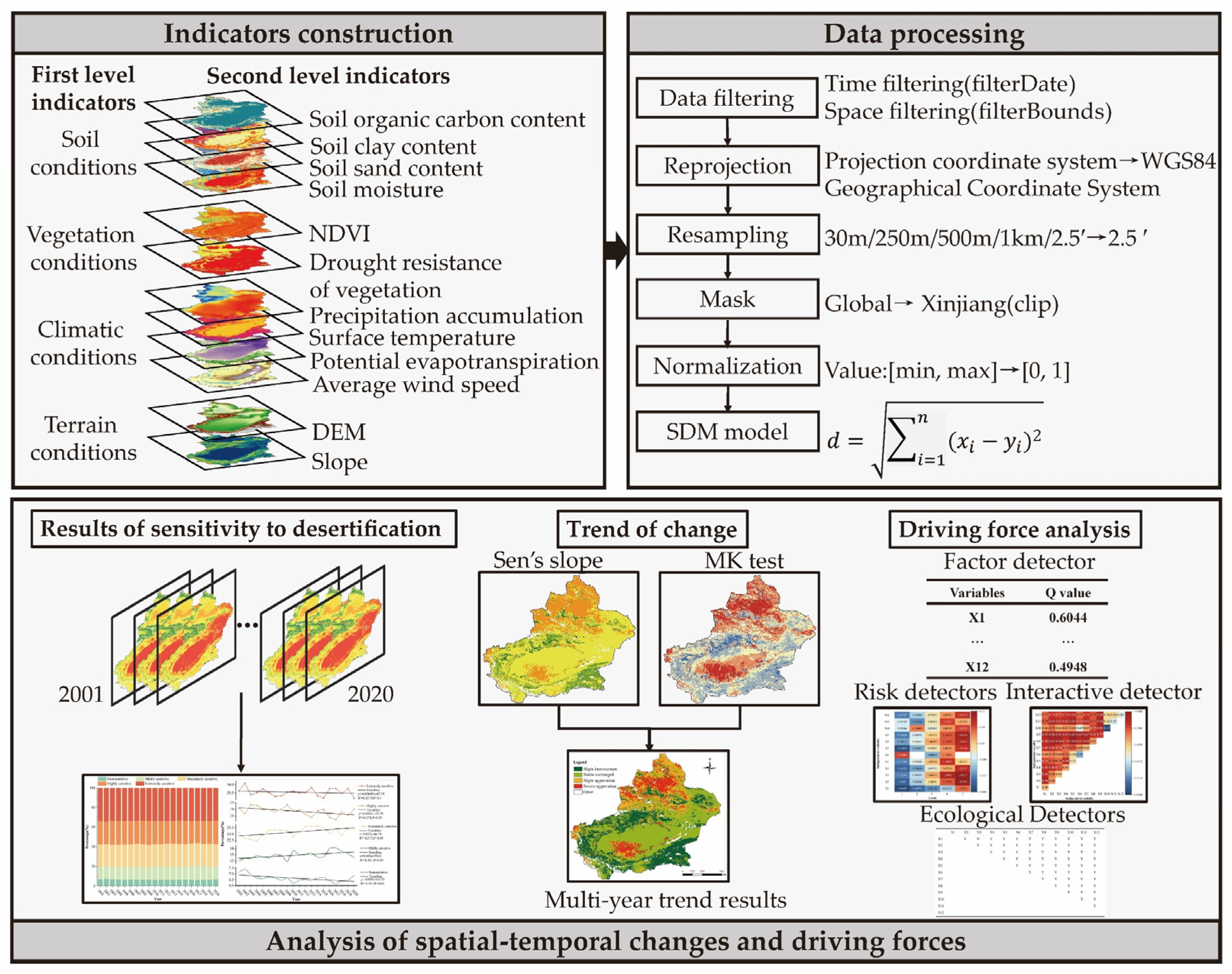
1. Instruction
- (1)
- What are the spatial and temporal distribution characteristics of Xinjiang’s land sensitivity to desertification?
- (2)
- What is the trend of land sensitivity to desertification in the last 20 years?
- (3)
- What is the driving effect of the evaluation indicators on land sensitivity to desertification?
2. Study Area and Data Sources
2.1. Study Area
2.2. Data Sources
3. Methods
3.1. Assessment of Sensitivity to Desertification
3.2. Sen’s Slope
3.3. Mann–Kendall Test
3.4. Geodetector
4. Results
4.1. Spatiotemporal Distribution Patterns of Desertification Sensitivity
4.2. Spatial Divergence of First-Level Indicators
4.3. Temporal Trends in Desertification Sensitivity
4.4. Attribution Analysis of Desertification Sensitivity
5. Discussion
5.1. Evaluation Indicators Selection
5.2. Comparison with Previous Studies
5.3. Policy Implication
6. Conclusions
Author Contributions
Funding
Data Availability Statement
Acknowledgments
Conflicts of Interest
References
- Wang, Y.; Zhang, J.; Tong, S.; Guo, E. Monitoring the trends of aeolian desertified lands based on time-series remote sensing data in the Horqin Sandy Land, China. Catena 2017, 157, 286–298. [Google Scholar] [CrossRef]
- Sarparast, M.; Ownegh, M.; Sepehr, A. Evaluating the impacts of combating-action programs on desertification hazard trends: A case study of Taybad-Bakharz region, northeastern Iran. Environ. Sustain. Indic. 2020, 7, 100043. [Google Scholar] [CrossRef]
- Chasek, P.S. The convention to combat desertification: Lessons learned for sustainable development. J. Environ. Dev. 1997, 6, 147–169. [Google Scholar] [CrossRef]
- Hulme, M.; Kelly, M. Exploring the links between desertification and climate change. Environ. Sci. Policy Sustain. Dev. 1993, 35, 4–45. [Google Scholar] [CrossRef]
- Sivakumar, M.V.K. Interactions between climate and desertification. Agric. For. Meteorol. 2007, 142, 143–155. [Google Scholar] [CrossRef]
- Alibekov, L.; Alibekov, D. Causes and Socio-Economic Consequences of Desertification in Central Asia: Causes and Consequences of Desertification. In The Socio-Economic Causes and Consequences of Desertification in Central Asia; Springer: Berlin/Heidelberg, Germany, 2008. [Google Scholar] [CrossRef]
- Feng, Q.; Tian, Y.; Yu, T.; Yin, Z.; Cao, S. Combating desertification through economic development in northwestern China. Land Degrad. Dev. 2019, 30, 910–917. [Google Scholar] [CrossRef]
- Mabbutt, J.A. A new global assessment of the status and trends of desertification. Environ. Conserv. 1984, 11, 103–113. [Google Scholar] [CrossRef]
- Ma, X.; Zhu, J.; Yan, W.; Zhao, C. Projections of desertification trends in Central Asia under global warming scenarios. Sci. Total Environ. 2021, 781, 146777. [Google Scholar] [CrossRef]
- Stringer, L.C.; Dyer, J.C.; Reed, M.S.; Dougill, A.J.; Twyman, C.; Mkwambisi, D. Adaptations to climate change, drought and desertification: Local insights to enhance policy in southern Africa. Environ. Sci. Policy 2009, 12, 748–765. [Google Scholar] [CrossRef]
- Ma, Z.; Xie, Y.; Jiao, J.; Wang, X. The construction and application of an Aledo-NDVI based desertification monitoring model. Procedia Environ. Sci. 2011, 10, 2029–2035. [Google Scholar] [CrossRef]
- Lamchin, M.; Lee, J.-Y.; Lee, W.-K.; Lee, E.J.; Kim, M.; Lim, C.-H.; Choi, H.-A.; Kim, S.-R. Assessment of land cover change and desertification using remote sensing technology in a local region of Mongolia. Adv. Space Res. 2016, 57, 64–77. [Google Scholar] [CrossRef]
- Zerrouki, Y.; Harrou, F.; Zerrouki, N.; Dairi, A.; Sun, Y. Desertification detection using an improved variational autoencoder-based approach through ETM-landsat satellite data. IEEE J. Sel. Top. Appl. Earth Obs. Remote Sens. 2020, 14, 202–213. [Google Scholar] [CrossRef]
- Tripathy, G.; Ghosh, T.; Shah, S. Monitoring of desertification process in Karnataka state of India using multi-temporal remote sensing and ancillary information using GIS. Int. J. Remote Sens. 1996, 17, 2243–2257. [Google Scholar] [CrossRef]
- Afrasinei, G.-M.; Melis, M.T.; Buttau, C.; Arras, C.; Pistis, M.; Zerrim, A.; Guied, M.; Ouessar, M.; Essifi, B.; Zaied, M.B. Classification methods for detecting and evaluating changes in desertification-related features in arid and semiarid environments. Euro-Mediterr. J. Environ. Integr. 2017, 2, 1–19. [Google Scholar] [CrossRef]
- Tomasella, J.; Vieira, R.M.S.P.; Barbosa, A.A.; Rodriguez, D.A.; de Oliveira Santana, M.; Sestini, M.F. Desertification trends in the Northeast of Brazil over the period 2000–2016. Int. J. Appl. Earth Obs. Geoinf. 2018, 73, 197–206. [Google Scholar] [CrossRef]
- Zhang, J.; Guan, Q.; Du, Q.; Ni, F.; Mi, J.; Luo, H.; Shao, W. Spatial and temporal dynamics of desertification and its driving mechanism in Hexi region. Land Degrad. Dev. 2022, 33, 3539–3556. [Google Scholar] [CrossRef]
- Hillel, D.; Rosenzweig, C. Desertification in relation to climate variability and change. Adv. Agron. 2002, 77, 1–38. [Google Scholar] [CrossRef]
- Guo, B.; Wei, C.; Yu, Y.; Liu, Y.; Li, J.; Meng, C.; Cai, Y. The dominant influencing factors of desertification changes in the source region of Yellow River: Climate change or human activity? Sci. Total Environ. 2022, 813, 152512. [Google Scholar] [CrossRef]
- Santini, M.; Caccamo, G.; Laurenti, A.; Noce, S.; Valentini, R. A multi-component GIS framework for desertification risk assessment by an integrated index. Appl. Geogr. 2010, 30, 394–415. [Google Scholar] [CrossRef]
- Lamqadem, A.A.; Saber, H.; Pradhan, B. Quantitative assessment of desertification in an arid oasis using remote sensing data and spectral index techniques. Remote Sens. 2018, 10, 1862. [Google Scholar] [CrossRef]
- Kosmas, C.; Kirkby, M.; Geeson, N. The MEDALUS Project: Mediterranean Desertification and Land Use; Manual on key indicators of Desertification mapping environmental sensitive areas to desertification; European Commission: Office for Official Publications of the European Communities: Luxembourg, 1999. [Google Scholar]
- Sterk, G.; Boardman, J.; Verdoodt, A. Desertification: History, causes and options for its control. Land Degrad. Dev. 2016, 27, 1783–1787. [Google Scholar] [CrossRef]
- Salvati, L.; Bajocco, S. Land sensitivity to desertification across Italy: Past, present, and future. Appl. Geogr. 2011, 31, 223–231. [Google Scholar] [CrossRef]
- Salvati, L.; Zitti, M.; Perini, L. Fifty years on: Long-term patterns of land sensitivity to desertification in Italy. Land Degrad. Dev. 2016, 27, 97–107. [Google Scholar] [CrossRef]
- Egidi, G.; Cividino, S.; Paris, E.; Palma, A.; Salvati, L.; Cudlin, P. Assessing the impact of multiple drivers of land sensitivity to desertification in a Mediterranean country. Environ. Impact Assess. Rev. 2021, 89, 106594. [Google Scholar] [CrossRef]
- Joy, R.; Das, S. Monitoring land sensitivity to desertification using the ESAI approach and evaluation of the key indicators: A spatio-temporal study in India. Land Degrad. Dev. 2021, 32, 3045–3061. [Google Scholar] [CrossRef]
- Jiang, L.; Bao, A.; Jiapaer, G.; Guo, H.; Zheng, G.; Gafforov, K.; Kurban, A.; De Maeyer, P. Monitoring land sensitivity to desertification in Central Asia: Convergence or divergence? Sci. Total Environ. 2019, 658, 669–683. [Google Scholar] [CrossRef]
- Kairis, O.; Karamanos, A.; Voloudakis, D.; Kapsomenakis, J.; Aratzioglou, C.; Zerefos, C.; Kosmas, C. Identifying degraded and sensitive to desertification agricultural soils in Thessaly, Greece, under simulated future climate scenarios. Land 2022, 11, 395. [Google Scholar] [CrossRef]
- Sepehr, A.; Hassanli, A.; Ekhtesasi, M.; Jamali, J. Quantitative assessment of desertification in south of Iran using MEDALUS method. Environ. Monit. Assess. 2007, 134, 243–254. [Google Scholar] [CrossRef]
- Uzuner, Ç.; Dengiz, O. Desertification risk assessment in Turkey based on environmentally sensitive areas. Ecol. Indic. 2020, 114, 106295. [Google Scholar] [CrossRef]
- Shao, W.; Wang, Q.; Guan, Q.; Zhang, J.; Yang, X.; Liu, Z. Environmental sensitivity assessment of land desertification in the Hexi Corridor, China. Catena 2023, 220, 106728. [Google Scholar] [CrossRef]
- Ferrara, A.; Kosmas, C.; Salvati, L.; Padula, A.; Mancino, G.; Nolè, A. Updating the MEDALUS-ESA framework for worldwide land degradation and desertification assessment. Land Degrad. Dev. 2020, 31, 1593–1607. [Google Scholar] [CrossRef]
- Guo, Z.; Wei, W.; Shi, P.; Zhou, L.; Wang, X. Spatiotemporal changes of land desertification sensitivity in the arid region of Northwest China. Acta Geogr. Sin. 2020, 75, 1948–1965. [Google Scholar] [CrossRef]
- Wilson, A.M.; Jetz, W. Remotely sensed high-resolution global cloud dynamics for predicting ecosystem and biodiversity distributions. PLoS Biol. 2016, 14, e1002415. [Google Scholar] [CrossRef] [PubMed]
- C Vega, G.; Pertierra, L.R.; Olalla-Tárraga, M.Á. MERRAclim, a high-resolution global dataset of remotely sensed bioclimatic variables for ecological modelling. Sci. Data 2017, 4, 170078. [Google Scholar] [CrossRef] [PubMed]
- Gorelick, N.; Hancher, M.; Dixon, M.; Ilyushchenko, S.; Thau, D.; Moore, R. Google Earth Engine: Planetary-scale geospatial analysis for everyone. Remote Sens. Environ. 2017, 202, 18–27. [Google Scholar] [CrossRef]
- Kumar, L.; Mutanga, O. Google Earth Engine Applications Since Inception: Usage, Trends, and Potential. Remote Sens. 2018, 10, 1509. [Google Scholar] [CrossRef]
- Amani, M.; Ghorbanian, A.; Ahmadi, S.A.; Kakooei, M.; Moghimi, A.; Mirmazloumi, S.M.; Moghaddam, S.H.A.; Mahdavi, S.; Ghahremanloo, M.; Parsian, S. Google earth engine cloud computing platform for remote sensing big data applications: A comprehensive review. IEEE J. Sel. Top. Appl. Earth Obs. Remote Sens. 2020, 13, 5326–5350. [Google Scholar] [CrossRef]
- Jamali, A.A.; Kalkhajeh, R.G.; Randhir, T.O.; He, S. Modeling relationship between land surface temperature anomaly and environmental factors using GEE and Giovanni. J. Environ. Manag. 2022, 302, 113970. [Google Scholar] [CrossRef]
- Elnashar, A.; Zeng, H.; Wu, B.; Gebremicael, T.G.; Marie, K. Assessment of environmentally sensitive areas to desertification in the Blue Nile Basin driven by the MEDALUS-GEE framework. Sci. Total Environ. 2022, 815, 152925. [Google Scholar] [CrossRef]
- Chen, X.; Bao, A.; Wang, X.; Hang, Y. Ecological Effect Evaluation of Comprehensive Control Project in Tarim River Basin. Bull. Chin. Acad. Sci. 2017, 32, 20–28. [Google Scholar] [CrossRef]
- Fu, A.; Li, W.; Chen, Y.; Wang, Y.; Hao, H.; Li, Y.; Sun, F.; Zhou, H.; Zhu, C.; Hao, X. The effects of ecological rehabilitation projects on the resilience of an extremely drought-prone desert riparian forest ecosystem in the Tarim River Basin, Xinjiang, China. Sci. Rep. 2021, 11, 18485. [Google Scholar] [CrossRef] [PubMed]
- Yu, T.; Liu, P.; Zhang, Q.; Ren, Y.; Yao, J. Detecting Forest Degradation in the Three-North Forest Shelterbelt in China from Multi-Scale Satellite Images. Remote Sens. 2021, 13, 1131. [Google Scholar] [CrossRef]
- Zhu, B.; Yu, X.; Qin, X.; Liu, Z.; Xiong, H. Formation and evolution of sandy deserts in Xinjiang:The palaeo-environmental evidences. Acta Geogr. Sin. 2013, 68, 661–679. [Google Scholar] [CrossRef]
- Li, X.; Jiang, F.; Li, L.; Wang, G. Spatial and temporal variability of precipitation concentration index, concentration degree and concentration period in Xinjiang, China. Int. J. Climatol. 2011, 31, 1679–1693. [Google Scholar] [CrossRef]
- Spinoni, J.; Vogt, J.; Naumann, G.; Carrao, H.; Barbosa, P. Towards identifying areas at climatological risk of desertification using the Köppen–Geiger classification and FAO aridity index. Int. J. Climatol. 2015, 35, 2210–2222. [Google Scholar] [CrossRef]
- National Center for Atmospheric Research (NCAR). TerraClimate: Global, High-Resolution Gridded Temperature, Precipitation, and Other Water Balance Variables. Available online: https://climatedataguide.ucar.edu/climate-data/terraclimate-global-high-resolution-gridded-temperature-precipitation-and-other-water (accessed on 9 June 2022).
- Wang, J.; Wang, Y.; Yan, C.; Qi, Y. 1:100,000 Desert (Sand) Distribution Dataset in China. National Tibetan Plateau/Third Pole Environment Data Center. Available online: https://data.tpdc.ac.cn/zh-hans/data/122c9ac2-53ee-4b9a-ae87-1a980b131c9b/ (accessed on 9 June 2022).
- Abatzoglou, J.T.; Dobrowski, S.Z.; Parks, S.A.; Hegewisch, K.C. TerraClimate, a high-resolution global dataset of monthly climate and climatic water balance from 1958–2015. Sci. Data 2018, 5, 170191. [Google Scholar] [CrossRef]
- National Aeronautics and Space Administration (NASA). General Accuracy Statement of Vegetation Indices (MOD13). Available online: https://modis-land.gsfc.nasa.gov/ValStatus.php?ProductID=MOD13 (accessed on 9 June 2022).
- Yang, Y.; Xiao, P.; Feng, X.; Li, H. Accuracy assessment of seven global land cover datasets over China. ISPRS J. Photogramm. Remote Sens. 2017, 125, 156–173. [Google Scholar] [CrossRef]
- Uuemaa, E.; Ahi, S.; Montibeller, B.; Muru, M.; Kmoch, A. Vertical accuracy of freely available global digital elevation models (ASTER, AW3D30, MERIT, TanDEM-X, SRTM, and NASADEM). Remote Sens. 2020, 12, 3482. [Google Scholar] [CrossRef]
- OpenLandMap. OpenLandMap Soil Organic Carbon Content. Available online: https://zenodo.org/record/2536040#.ZC7gvnZBxPY (accessed on 9 June 2022).
- OpenLandMap. OpenLandMap Soil Sand Content. Available online: https://zenodo.org/record/1476852#.ZC7hInZBxPY (accessed on 9 June 2022).
- OpenLandMap. OpenLandMap Soil Clay Content. Available online: https://zenodo.org/record/2525663#.ZC7hkHZBxPY (accessed on 9 June 2022).
- United States Geological Survey (USGS). MOD13A2.061 Terra Vegetation Indices 16-Day Global 1 km. Available online: https://lpdaac.usgs.gov/products/mod13a2v061/ (accessed on 9 June 2022).
- United States Geological Survey (USGS). MCD12Q1.061 MODIS Land Cover Type Yearly Global 500 m. Available online: https://lpdaac.usgs.gov/products/mcd12q1v061/ (accessed on 9 June 2022).
- United States Geological Survey (USGS). MOD11A2.061 Terra Land Surface Temperature and Emissivity 8-Day Global 1 km. Available online: https://lpdaac.usgs.gov/products/mod11a2v061/ (accessed on 9 June 2022).
- National Aeronautics and Space Administration (NASA). NASADEM: NASA NASADEM Digital Elevation 30 m. Available online: https://lpdaac.usgs.gov/products/nasadem_hgtv001/ (accessed on 9 June 2022).
- Chardon, J.P.; Adriaensen, F.; Matthysen, E. Incorporating landscape elements into a connectivity measure: A case study for the Speckled wood butterfly (Pararge aegeria L.). Landsc. Ecol. 2003, 18, 561–573. [Google Scholar] [CrossRef]
- Vignieri, S.N. Streams over mountains: Influence of riparian connectivity on gene flow in the Pacific jumping mouse (Zapus trinotatus). Mol. Ecol. 2005, 14, 1925–1937. [Google Scholar] [CrossRef]
- Murad, A. Planning and location of health care services in Jeddah City, Saudi Arabia: Discussion of the constructive use of geographical information systems. Geospat. Health 2018, 13, 322–329. [Google Scholar] [CrossRef] [PubMed]
- Liu, X.; Pan, Y.; Zhu, X.; Li, S. Spatiotemporal variation of vegetation coverage in Qinling-Daba Mountains in relation to environmental factors. J. Geogr. Sci. 2015, 26, 45–58. [Google Scholar] [CrossRef]
- Pandey, B.K.; Khare, D. Identification of trend in long term precipitation and reference evapotranspiration over Narmada river basin (India). Glob. Planet. Chang. 2018, 161, 172–182. [Google Scholar] [CrossRef]
- Waked, A.; Sauvage, S.; Borbon, A.; Gauduin, J.; Pallares, C.; Vagnot, M.-P.; Léonardis, T.; Locoge, N. Multi-year levels and trends of non-methane hydrocarbon concentrations observed in ambient air in France. Atmos. Environ. 2016, 141, 263–275. [Google Scholar] [CrossRef]
- Song, Y.; Wang, J.; Ge, Y.; Xu, C. An optimal parameters-based geographical detector model enhances geographic characteristics of explanatory variables for spatial heterogeneity analysis: Cases with different types of spatial data. GIScience Remote Sens. 2020, 57, 593–610. [Google Scholar] [CrossRef]
- Wang, J.; Xu, C. Geodetector: Principle and prospective. Acta Geogr. Sin. 2017, 72, 116–134. [Google Scholar] [CrossRef]
- Du, Z.; Xu, X.; Zhang, H.; Wu, Z.; Liu, Y. Geographical Detector-Based Identification of the Impact of Major Determinants on Aeolian Desertification Risk. PLoS ONE 2016, 11, e0151331. [Google Scholar] [CrossRef]
- Liu, Y.; Yang, R. The Spatial Characteristics and Formation Mechanism of the County Urbanization in China. Acta Geogr. Sin. 2012, 67, 1011–1020. [Google Scholar] [CrossRef]
- Ren, Y.; Deng, L.; Zuo, S.; Luo, Y.; Shao, G.; Wei, X.; Hua, L.; Yang, Y. Geographical modeling of spatial interaction between human activity and forest connectivity in an urban landscape of southeast China. Landsc. Ecol. 2014, 29, 1741–1758. [Google Scholar] [CrossRef]
- Zhang, M.; Kafy, A.-A.; Ren, B.; Zhang, Y.; Tan, S.; Li, J. Application of the optimal parameter geographic detector model in the identification of influencing factors of ecological quality in Guangzhou, China. Land 2022, 11, 1303. [Google Scholar] [CrossRef]
- Meng, X.; Gao, X.; Lei, J.; Li, S. Development of a multiscale discretization method for the geographical detector model. Int. J. Geogr. Inf. Sci. 2021, 35, 1650–1675. [Google Scholar] [CrossRef]
- Meng, Z.; Dang, X.; Gao, Y.; Ren, X.; Ding, Y.; Wang, M. Interactive effects of wind speed, vegetation coverage and soil moisture in controlling wind erosion in a temperate desert steppe, Inner Mongolia of China. J. Arid Land 2018, 10, 534–547. [Google Scholar] [CrossRef]
- Daly, C.; Conklin, D.R.; Unsworth, M.H. Local atmospheric decoupling in complex topography alters climate change impacts. Int. J. Climatol. 2010, 30, 1857–1864. [Google Scholar] [CrossRef]
- Veron, S.R.; Paruelo, J.M. Desertification alters the response of vegetation to changes in precipitation. J. Appl. Ecol. 2010, 47, 1233–1241. [Google Scholar] [CrossRef]
- Li, F.; Zhao, W.; Liu, H. Productivity responses of desert vegetation to precipitation patterns across a rainfall gradient. J. Plant Res. 2015, 128, 283–294. [Google Scholar] [CrossRef] [PubMed]
- Daham, A.; Han, D.; Rico-Ramirez, M.; Marsh, A. Analysis of NVDI variability in response to precipitation and air temperature in different regions of Iraq, using MODIS vegetation indices. Environ. Earth Sci. 2018, 77, 1–24. [Google Scholar] [CrossRef]
- Liu, C.; Yan, X.; Jiang, F. Desert vegetation responses to the temporal distribution patterns of precipitation across the northern Xinjiang, China. Catena 2021, 206, 105544. [Google Scholar] [CrossRef]
- Wang, Y. Phenological observations of short-lived and short-lived-like plants in early spring in Xinjiang. Arid Zone Res. 1993, 10, 34–39. [Google Scholar] [CrossRef]
- Shan, N.; Shi, Z.; Yang, X.; Zhang, X.; Guo, H.; Zhang, B.; Zhang, Z. Trends in potential evapotranspiration from 1960 to 2013 for a desertification-prone region of China. Int. J. Climatol. 2016, 36, 3434–3445. [Google Scholar] [CrossRef]
- Joseph, O.; Gbenga, A.E.; Langyit, D.G. Desertification risk analysis and assessment in Northern Nigeria. Remote Sens. Appl. Soc. Environ. 2018, 11, 70–82. [Google Scholar] [CrossRef]
- Zhang, C.; Wang, X.; Li, J.; Hua, T. Identifying the effect of climate change on desertification in northern China via trend analysis of potential evapotranspiration and precipitation. Ecol. Indic. 2020, 112, 106141. [Google Scholar] [CrossRef]
- Ziadat, F.M.; Taimeh, A.Y. Effect of rainfall intensity, slope, land use and antecedent soil moisture on soil erosion in an arid environment. Land Degrad. Dev. 2013, 24, 582–590. [Google Scholar] [CrossRef]
- Xu, D.; You, X.; Xia, C. Assessing the spatial-temporal pattern and evolution of areas sensitive to land desertification in North China. Ecol. Indic. 2019, 97, 150–158. [Google Scholar] [CrossRef]
- Karavitis, C.A.; Tsesmelis, D.E.; Oikonomou, P.D.; Kairis, O.; Kosmas, C.; Fassouli, V.; Ritsema, C.; Hessel, R.; Jetten, V.; Moustakas, N.; et al. A desertification risk assessment decision support tool (DRAST). Catena 2020, 187. [Google Scholar] [CrossRef]
- Curto, J.D.; Pinto, J.C. New multicollinearity indicators in linear regression models. Int. Stat. Rev. 2007, 75, 114–121. [Google Scholar] [CrossRef]
- Ouyang, Z.; Wang, X.; Miao, H. China’s eco-environmental sensitivity and its spatial heterogeneity. Acta Ecol. Sin. 1994, 20, 10–13. [Google Scholar] [CrossRef]
- Zhao, M.; Zhao, W.; Jin, T.; An, Y.; Xu, H. Land Desertification Sensitivity Evaluation in Qinghai Lake Basin. Chin. Agric. Sci. Bull. 2012, 28, 32. [Google Scholar] [CrossRef]
- Tian, L.; Qiu, S.; Peng, J.; Yina, H. Desertification sensitivity assessment in Inner Mongolia Autonomous Region based on PSR framework. Prog. Geogr. 2018, 37, 1682–1692. [Google Scholar] [CrossRef]
- Zhang, F.; Yushanjiang, A.; Jing, Y. Assessing and predicting changes of the ecosystem service values based on land use/cover change in Ebinur Lake Wetland National Nature Reserve, Xinjiang, China. Sci. Total Environ. 2019, 656, 1133–1144. [Google Scholar] [CrossRef]
- Jing, Y.; Zhang, F.; He, Y.; Johnson, V.C.; Arikena, M. Assessment of spatial and temporal variation of ecological environment quality in Ebinur Lake Wetland National Nature Reserve, Xinjiang, China. Ecol. Indic. 2020, 110, 105874. [Google Scholar] [CrossRef]
- Ling, H.; Guo, B.; Zhang, G.; Xu, H.; Deng, X. Evaluation of the ecological protective effect of the “large basin” comprehensive management system in the Tarim River basin, China. Sci. Total Environ. 2019, 650, 1696–1706. [Google Scholar] [CrossRef] [PubMed]
- Sun, B.; Wang, X. On Assessment of Sandy Desertification Sensitivity in Xinjiang. J. Southwest China Norm. Univ. (Nat. Sci. Ed.) 2015, 40, 108–112. [Google Scholar] [CrossRef]


| Quality | Indicator | Variable | Spatial Resolution | Data Sources and References | Normalization |
|---|---|---|---|---|---|
| Soil | X1 | Soil organic carbon content | 250 m | OpenLandMap [54] | − |
| X2 | Soil sand content | 250 m | OpenLandMap [55] | + | |
| X3 | Soil clay content | 250 m | OpenLandMap [56] | − | |
| X4 | Soil moisture | 2.5′ | TERRACLIMATE [48] | − | |
| Vegetation | X5 | NDVI | 1 km | MOD13A2 [57] | − |
| X6 | Drought resistance | 500 m | MCD12Q1 [58] | + | |
| Climate | X7 | Precipitation | 2.5′ | TERRACLIMATE [48] | − |
| X8 | PET | 2.5′ | TERRACLIMATE [48] | + | |
| X9 | Surface temperature | 1 km | MOD11A2 [59] | + | |
| X10 | Average wind speed | 2.5′ | TERRACLIMATE [48] | + | |
| Terrain | X11 | DEM | 30 m | NASADEM [60] | − |
| X12 | Slope | 30 m | NASADEM [60] | − |
| Level | Area (km2) | X2 | X4 | X7 | X8 | X10 |
|---|---|---|---|---|---|---|
| Non-sensitive | 104,822.3 | 23–65 | 0.1–73.85 | 1.74–55.82 | 8.13–84.88 | 1.36–4.72 |
| Mildly sensitive | 206,175.1 | 20–73 | 0–132.5 | 1.25–56.34 | 0.04–96.36 | 1.15–5.11 |
| Moderately sensitive | 360,743 | 23–85 | 0–68.3 | 1.17–54.13 | 0–118.11 | 1.09–5.51 |
| Highly sensitive | 3,628,81.5 | 28–93 | 0–62.8 | 1.11–52.76 | 0–132.49 | 1.08–5.15 |
| Extremely sensitive | 548,083.3 | 30–100 | 0–22.9 | 0.93–23.73 | 1.45–140.55 | 1.06–5.03 |
| Variable | Nodes | q Value | Sig | |||
|---|---|---|---|---|---|---|
| X1 | 1000 | 2000 | 3000 | 5000 | 0.6044 | 0.000 * |
| X2 | 20,000 | 60,000 | 71,000 | 87,000 | 0.6570 | 0.000 * |
| X3 | 1000 | 6000 | 12,000 | 22,000 | 0.6025 | 0.000 * |
| X4 | 213 | 513 | 3706 | 6080 | 0.6477 | 0.000 * |
| X5 | 302,267 | 625,165 | 833,485 | 1,431,314 | 0.5457 | 0.000 * |
| X7 | 3537 | 7112 | 15,150 | 22,995 | 0.6153 | 0.000 * |
| X8 | 74,234 | 89,028 | 93,355 | 101,084 | 0.6668 | 0.000 * |
| X9 | 286,382 | 292,918 | 297,981 | 301,940 | 0.7946 | 0.000 * |
| X10 | 1640 | 2002 | 3078 | 3428 | 0.1676 | 0.000 * |
| X11 | 7870 | 14,030 | 19,090 | 38,590 | 0.4706 | 0.000 * |
| X12 | 136 | 1166 | 2050 | 3728 | 0.4948 | 0.000 * |
| X6 | — | — | — | — | 0.3776 | 0.000 * |
Disclaimer/Publisher’s Note: The statements, opinions and data contained in all publications are solely those of the individual author(s) and contributor(s) and not of MDPI and/or the editor(s). MDPI and/or the editor(s) disclaim responsibility for any injury to people or property resulting from any ideas, methods, instructions or products referred to in the content. |
© 2023 by the authors. Licensee MDPI, Basel, Switzerland. This article is an open access article distributed under the terms and conditions of the Creative Commons Attribution (CC BY) license (https://creativecommons.org/licenses/by/4.0/).
Share and Cite
Zhao, Y.; Li, S.; Yang, D.; Lei, J.; Fan, J. Spatiotemporal Changes and Driving Force Analysis of Land Sensitivity to Desertification in Xinjiang Based on GEE. Land 2023, 12, 849. https://doi.org/10.3390/land12040849
Zhao Y, Li S, Yang D, Lei J, Fan J. Spatiotemporal Changes and Driving Force Analysis of Land Sensitivity to Desertification in Xinjiang Based on GEE. Land. 2023; 12(4):849. https://doi.org/10.3390/land12040849
Chicago/Turabian StyleZhao, Yazhou, Shengyu Li, Dazhi Yang, Jiaqiang Lei, and Jinglong Fan. 2023. "Spatiotemporal Changes and Driving Force Analysis of Land Sensitivity to Desertification in Xinjiang Based on GEE" Land 12, no. 4: 849. https://doi.org/10.3390/land12040849
APA StyleZhao, Y., Li, S., Yang, D., Lei, J., & Fan, J. (2023). Spatiotemporal Changes and Driving Force Analysis of Land Sensitivity to Desertification in Xinjiang Based on GEE. Land, 12(4), 849. https://doi.org/10.3390/land12040849