Application of GPR Prospection to Unveil Historical Stratification inside Monumental Buildings: The Case of San Leonardo de Siete Fuentes in Santu Lussurgiu, Sardinia, Italy
Abstract
1. Introduction
2. Materials and Methods: The Site of Study
2.1. The Fabric of San Leonardo de Siete Fuentes in Santu Lussurgiu, Sardinia, Italy
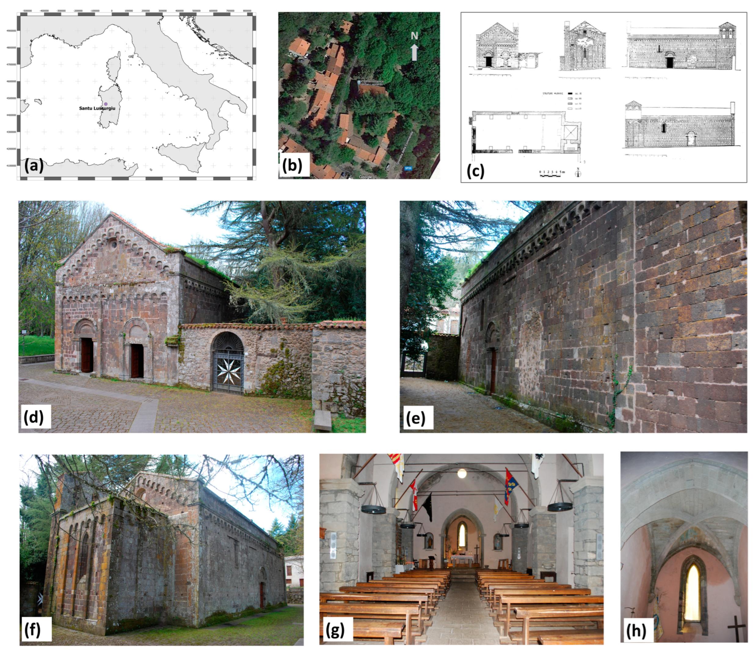
Description of the Fabric
2.2. The Problem of Dating the Building Stages: History of the Church of San Leonardo and of the Critics
2.2.1. Critics and History on the First Building Stages
2.2.2. Historical Documents Related to the Expansion
2.2.3. Stylistic Comparison with Other Monuments in the Region of Known Building Time (for Dating to XIV the Most Part of the Current Structure)
2.2.4. Critics on the First-Stage Building
3. Materials and Methods: The Experimental Framework
3.1. GPR Analysis: Acquisition and Standard Processing
- Remove header gain
- Subtract-mean (dewow)
- Move start-time
- Background removal
- Divergence compensation
- Energy decay
- Bandpass Butterworth (50–700 MHz)
- Multiplication
- Declipping plateau
- Time-to-depth conversion
- Signal envelope by Hilbert transform (only for C-scans or depth-slices)
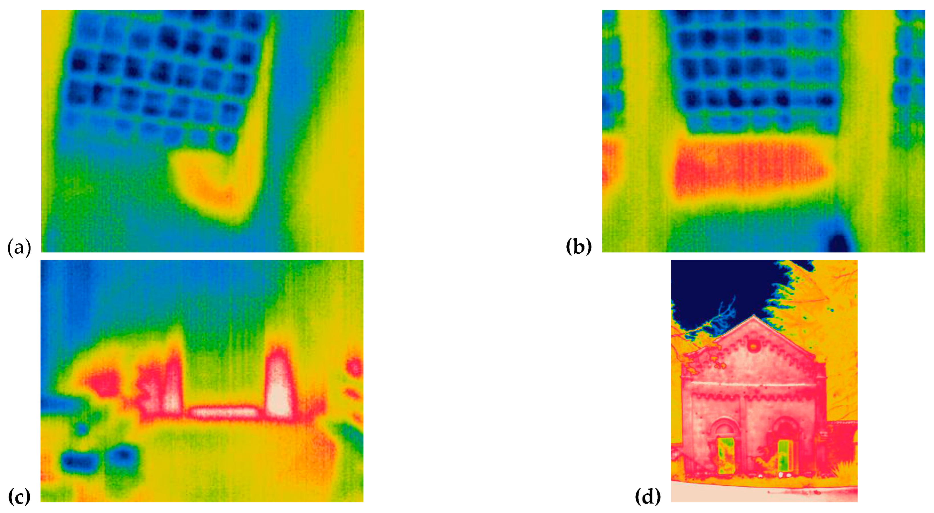
3.2. IR Thermography: Technique and Acquisitions
4. Results and Discussion
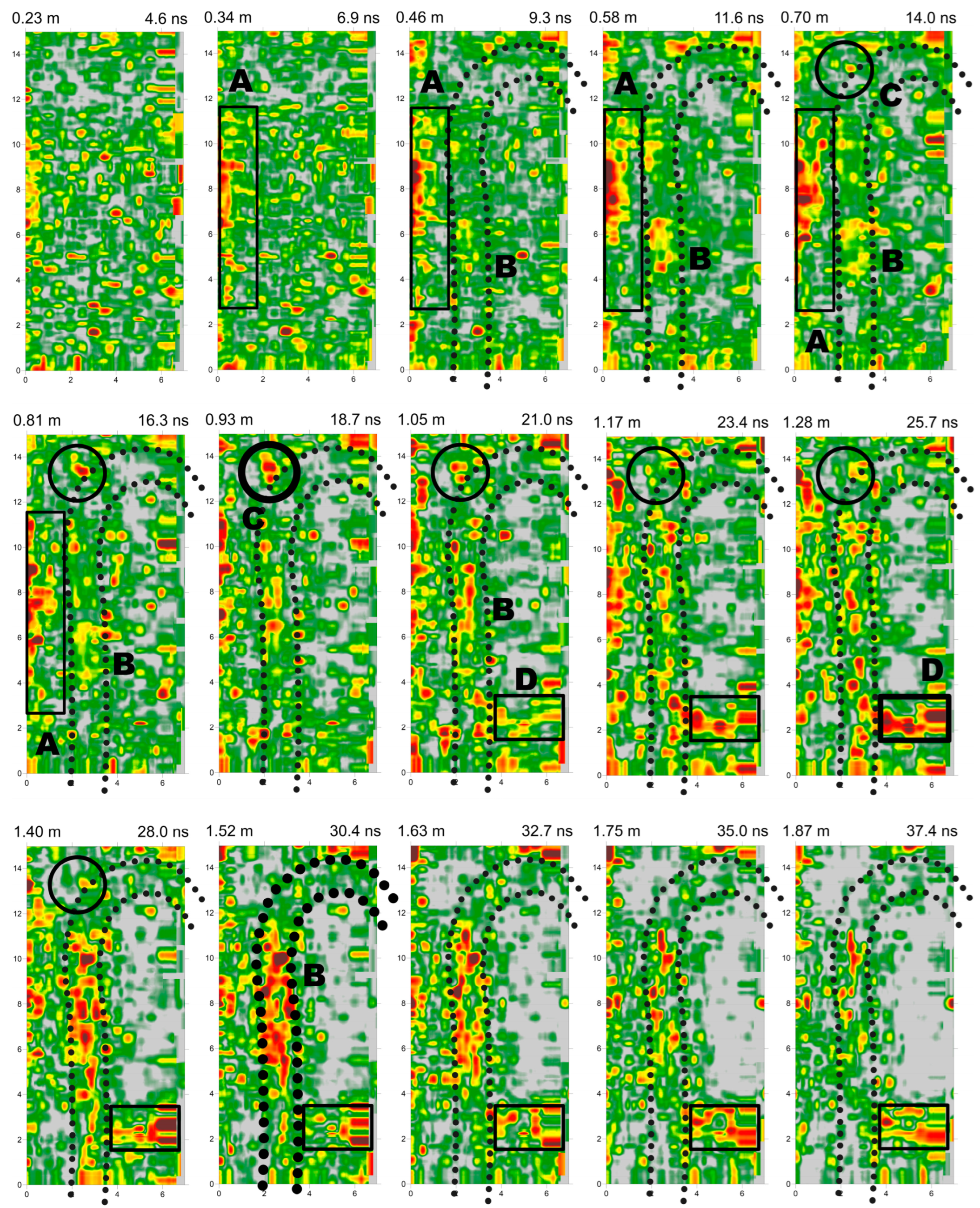
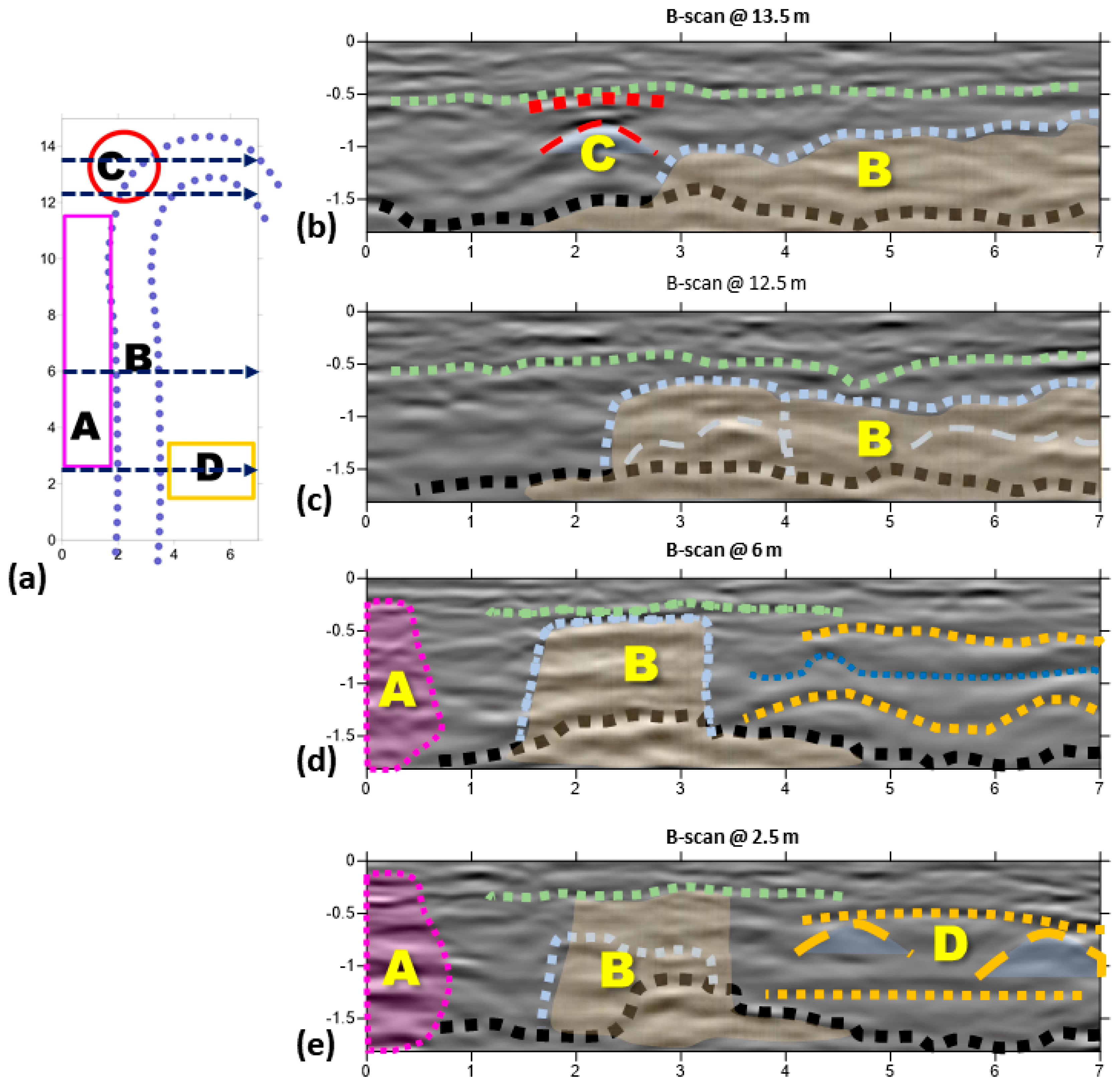
4.1. 2D Geophysical Results and Discussion
4.2. Further 2D and 3D Analysis
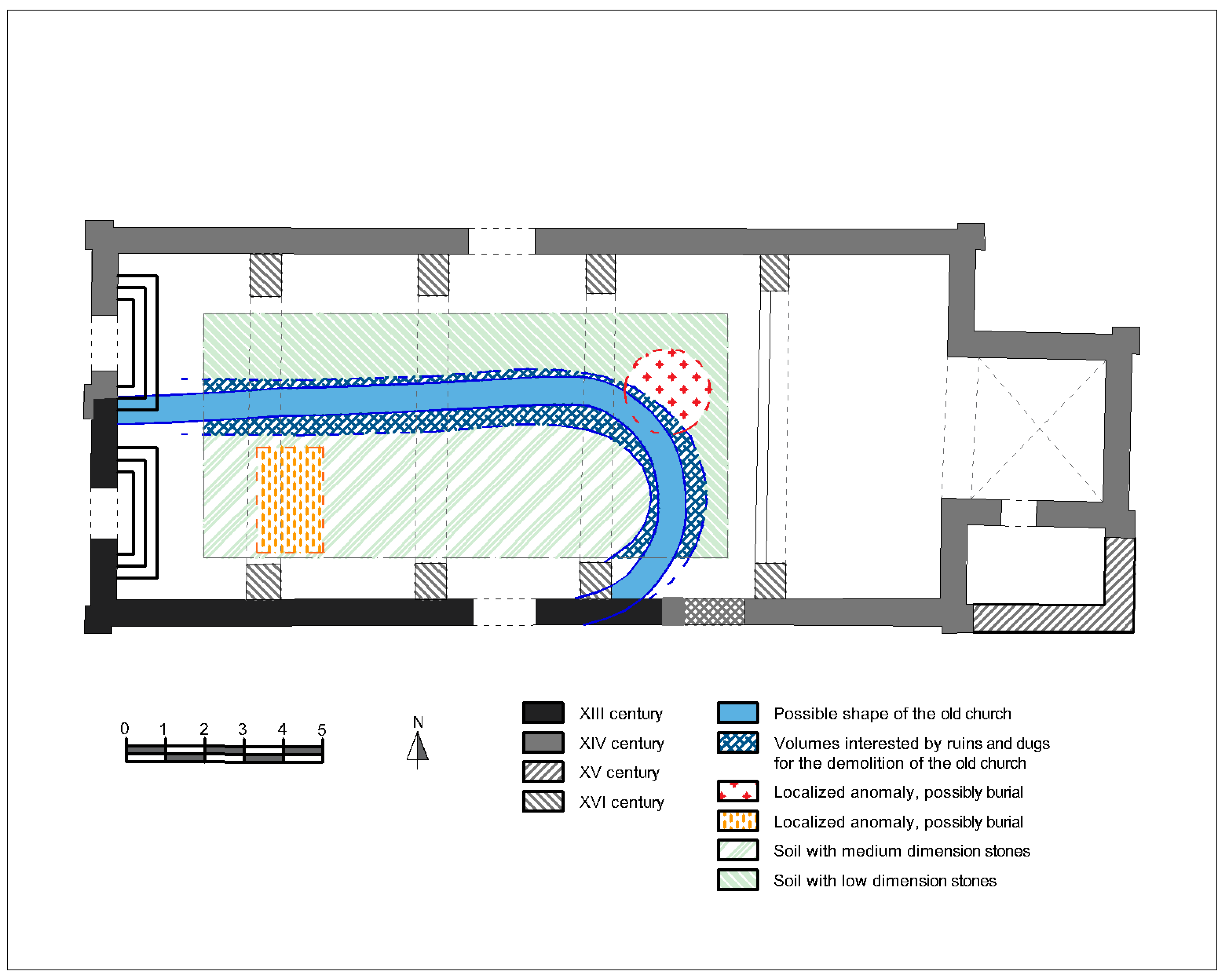
4.3. Further Discussion
5. Concluding Remarks
Author Contributions
Funding
Data Availability Statement
Acknowledgments
Conflicts of Interest
References
- Stratigraphy (Archaeology) @ Wikipedia.org. Available online: https://en.wikipedia.org/wiki/Stratigraphy_(archaeology) (accessed on 28 January 2023).
- Harris, E.C. Principles of Archaeological Stratigraphy, 2nd ed.; Academic Press: London, UK, 1989. [Google Scholar]
- Compare, V.; Cozzolino, M.; Mauriello, P.; Patella, D. Resistivity probability tomography imaging at the Castle of Zena, Italy. EURASIP J. Image Video Process. 2009, 2009, 693274. [Google Scholar] [CrossRef]
- Papadopoulos, N.G.; Sarris, A.; Parkinson, W.A.; Gyucha, A.; Yerkes, R.W.; Duffy, P.R.; Tsourlos, P. Electrical resistivity tomography for the modelling of cultural deposits and geomophological landscapes at Neolithic sites: A case study from Southeastern Hungary. Archaeol. Prospect. 2014, 21, 169–183. [Google Scholar] [CrossRef]
- Piroddi, L.; Vignoli, G.; Trogu, A.; Deidda, G.P. Non-destructive Diagnostics of Architectonic Elements in San Giuseppe Calasanzio’s Church in Cagliari: A Test-case for Micro-geophysical Methods within the Framework of Holistic/integrated Protocols for Artefact Knowledge. In Proceedings of the 2018 Metrology for Archaeology and Cultural Heritage (MetroArchaeo), Cassino, Italy, 22–24 October 2018; pp. 17–21. [Google Scholar]
- Fischanger, F.; Catanzariti, G.; Comina, C.; Sambuelli, L.; Morelli, G.; Barsuglia, F.; Ellaithy, A.; Porcelli, F. Geophysical anomalies detected by electrical resistivity tomography in the area surrounding Tutankhamun’s tomb. J. Cult. Herit. 2019, 36, 63–71. [Google Scholar] [CrossRef]
- Cozzolino, M.; Gentile, V.; Mauriello, P.; Peditrou, A. Non-destructive techniques for building evaluation in urban areas: The case study of the redesigning project of Eleftheria square (Nicosia, Cyprus). Appl. Sci. 2020, 10, 4296. [Google Scholar] [CrossRef]
- Piroddi, L.; Calcina, S.V.; Trogu, A.; Ranieri, G. Automated Resistivity Profiling (ARP) to explore wide archaeological areas: The prehistoric site of Mont’e Prama, Sardinia, Italy. Remote Sens. 2020, 12, 461. [Google Scholar] [CrossRef]
- Barbieri, A.; Regala, F.T.; Cascalheira, J.; Bicho, N. The sediment at the end of the tunnel: Geophysical research to locate the Pleistocene entrance of Gruta da Companheira (Algarve, Southern Portugal). Archaeol. Prospect. 2022, 1–18. [Google Scholar] [CrossRef]
- Deiana, R.; Deidda, G.P.; Cusí, E.D.; van Dommelen, P.; Stiglitz, A. FDEM and ERT measurements for archaeological prospections at Nuraghe S’Urachi (West-Central Sardinia). Archaeol. Prospect. 2022, 29, 69–86. [Google Scholar] [CrossRef]
- Vacilotto, A.; Deiana, R.; Mozzi, P. Understanding Ancient Landscapes in the Venetian Plain through an Integrated Geoarchaeological and Geophysical Approach. Remote Sens. 2020, 12, 2973. [Google Scholar] [CrossRef]
- Ranieri, G.; Calcina, S.V.; Piroddi, L. Preventive geophysical surveys for the evaluation of the archaeological risk: Examples from the region of the ancient Pylos (western Peloponnese, Greece). In Proceedings of the 2021 21st International Conference on Computational Science and Its Applications (ICCSA), Cagliari, Italy, 13–16 September 2021; pp. 242–250. [Google Scholar]
- Gaffney, C.; Gaffney, V.; Neubauer, W.; Baldwin, E.; Chapman, H.; Garwood, P.; Moulden, H.; Sparrow, T.; Bates, R.; Locker, K.; et al. The Stonehenge hidden landscapes project. Archaeol. Prospect. 2012, 19, 147–155. [Google Scholar] [CrossRef]
- Pisciotta, A.; Vitale, G.; Scudero, S.; Martorana, R.; Capizzi, P.; D’Alessandro, A. A lightweight prototype of a magnetometric system for unmanned aerial vehicles. Sensors 2021, 21, 4691. [Google Scholar] [CrossRef]
- Forte, E.; Pipan, M. Integrated seismic tomography and ground-penetrating radar (GPR) for the high-resolution study of burial mounds (tumuli). J. Archaeol. Sci. 2008, 35, 2614–2623. [Google Scholar] [CrossRef]
- Abu Zeid, N.; Corradini, E.; Bignardi, S.; Nizzo, V.; Santarato, G. The Passive Seismic Technique ‘HVSR’as a Reconnaissance Tool for Mapping Paleo-soils: The Case of the Pilastri Archaeological Site, Northern Italy. Archaeol. Prospect. 2017, 24, 245–258. [Google Scholar] [CrossRef]
- Pirinu, A.; Balia, R.; Piroddi, L.; Trogu, A.; Utzeri, M.; Vignoli, G. Deepening the knowledge of military architecture in an urban context through digital representations integrated with geophysical surveys. The city walls of Cagliari (Italy). In Proceedings of the 2018 Metrology for Archaeology and Cultural Heritage (MetroArchaeo), Cassino, Italy, 22–24 October 2018; pp. 211–215. [Google Scholar]
- Cardarelli, E.; De Donno, G.; Oliveti, I.; Scatigno, C. Threedimensional reconstruction of a masonry building through electrical and seismic tomography validated by biological analyses. Near. Surf. Geophys. 2018, 16, 53–65. [Google Scholar] [CrossRef]
- Sfarra, S.; Marcucci, E.; Ambrosini, D.; Paoletti, D. Infrared exploration of the architectural heritage: From passive infrared thermography to hybrid infrared thermography (HIRT) approach. Mater. Construcción 2016, 66, e094. [Google Scholar] [CrossRef]
- Piroddi, L.; Calcina, S.V.; Fiorino, D.R.; Grillo, S.; Trogu, A.; Vignoli, G. Geophysical and remote sensing techniques for evaluating historical stratigraphy and assessing the conservation status of defensive structures heritage: Preliminary results from the military buildings at San Filippo Bastion, Cagliari, Italy. In ICCSA 2020. Lecture Notes in Computer Science; Gervasi, O., Murgante, B., Misra, S., Garau, C., Blečić, I., Taniar, D., Apduhan, B.O., Rocha, A.M., Tarantino, E., Torre, C.M., et al., Eds.; Springer Nature: Cham, Switzerland, 2020; Volume 12255, pp. 944–959. [Google Scholar]
- Martorana, R.; Capizzi, P. Joint Investigation with Ground Penetrating Radar and Infrared Thermography as a Diagnostic Support for the Restoration of Two Wall Mosaics in the Church of St. Mary of the Admiral in Palermo, Italy. Heritage 2022, 5, 2298–2314. [Google Scholar] [CrossRef]
- Liang, H. Advances in multispectral and hyperspectral imaging for archaeology and art conservation. Appl. Phys. A 2012, 106, 309–323. [Google Scholar] [CrossRef]
- Legnaioli, S.; Lorenzetti, G.; Cavalcanti, G.H.; Grifoni, E.; Marras, L.; Tonazzini, A.; Salerno, E.; Pallecchi, P.; Giachi, G.; Palleschi, V. Recovery of archaeological wall paintings using novel multispectral imaging approaches. Herit. Sci. 2013, 1, 33. [Google Scholar] [CrossRef]
- Piroddi, L.; Ranieri, G.; Cogoni, M.; Trogu, A.; Loddo, F. Time and spectral multiresolution remote sensing for the study of ancient wall drawings at san salvatore hypogeum, Italy. In Proceedings of the 22nd European Meeting of Environmental and Engineering Geophysics, Near Surface Geoscience 2016, Barcelona, Spain, 4–8 September 2016; p. 5. [Google Scholar]
- Piroddi, L.; Calcina, S.V.; Trogu, A.; Vignoli, G. Towards the definition of a low-cost toolbox for qualitative inspection of painted historical vaults by means of modified DSLR cameras, open source programs and signal processing techniques. In ICCSA 2020. Lecture Notes in Computer Science; Gervasi, O., Murgante, B., Misra, S., Garau, C., Blečić, I., Taniar, D., Apduhan, B.O., Rocha, A.M., Tarantino, E., Torre, C.M., et al., Eds.; Springer Nature: Cham, Switzerland, 2020; Volume 12255, pp. 971–991. [Google Scholar]
- Tapete, D.; Casagli, N.; Fanti, R. Radar interferometry for early stage warning on monuments at risk. In Landslide Science and Practice; Margottini, C., Canuti, P., Sassa, K., Eds.; Springer: Berlin, Germany, 2013; pp. 619–625. [Google Scholar]
- Montuori, A.; Luzi, G.; Stramondo, S.; Casula, G.; Bignami, C.; Bonali, E.; Bianchi, M.G.; Crosetto, M. Combined use of ground-based systems for Cultural Heritage conservation monitoring. In Proceedings of the 2014 IEEE Geoscience and Remote Sensing Symposium, Québec City, QC, Canada, 13–18 July 2014; pp. 4086–4089. [Google Scholar]
- Calcina, S.V.; Piroddi, L.; Ranieri, G. Vibration analysis of historic bell towers by means of contact and remote sensing measurements. Nondestruct. Test. Eva. 2016, 3, 331–359. [Google Scholar] [CrossRef]
- Piroddi, L.; Calcina, S.V. Integrated vibration analysis for historical dome structures: A complementary approach based on conventional geophysical methods and remote sensing techniques. In ICCSA 2020. Lecture Notes in Computer Science; Gervasi, O., Murgante, B., Misra, S., Garau, C., Blečić, I., Taniar, D., Apduhan, B.O., Rocha, A.M., Tarantino, E., Torre, C.M., et al., Eds.; Springer Nature: Cham, Switzerland, 2020; Volume 12255, pp. 928–943. [Google Scholar]
- Chase, A.F.; Chase, D.Z.; Awe, J.J.; Weishampel, J.F.; Iannone, G.; Moyes, H.; Yaeger, J.; Brown, M.K.; Shrestha, R.L.; Carter, W.E.; et al. Ancient Maya regional settlement and inter-site analysis: The 2013 west-central Belize LiDAR survey. Remote Sens. 2014, 6, 8671–8695. [Google Scholar] [CrossRef]
- Inomata, T.; Triadan, D.; López, V.A.V.; Fernandez-Diaz, J.C.; Omori, T.; Bauer, M.B.M.; Hernandez, M.G.; Beach, T.; Cagnato, C.; Aoyama, K.; et al. Monumental architecture at Aguada Fénix and the rise of Maya civilization. Nature 2020, 582, 530–533. [Google Scholar] [CrossRef]
- Tapete, D.; Fanti, R.; Cecchi, R.; Petrangeli, P.; Casagli, N. Satellite radar interferometry for monitoring and early-stage warning of structural instability in archaeological sites. J. Geophys. Eng. 2012, 9, S10–S25. [Google Scholar] [CrossRef]
- Agapiou, A.; Lysandrou, V.; Lasaponara, R.; Masini, N.; Hadjimitsis, D.G. Study of the variations of archaeological marks at neolithic site of Lucera, Italy using high-resolution multispectral datasets. Remote Sens. 2016, 8, 723. [Google Scholar] [CrossRef]
- Moriarty, C.; Cowley, T.D.; Wade, C.; Nichol, C.J. Deploying multispectral remote sensing for multi-temporal analysis of archaeological crop stress at Ravenshall, Fife, Scotland. Archaeol. Prospect. 2019, 26, 33–46. [Google Scholar] [CrossRef]
- Chen, F.; Lasaponara, R.; Masini, N. An overview of satellite synthetic aperture radar remote sensing in archaeology: From site detection to monitoring. J. Cult. Herit. 2017, 23, 5–11. [Google Scholar] [CrossRef]
- Chen, F.; Masini, N.; Yang, R.; Milillo, P.; Feng, D.; Lasaponara, R. A space view of radar archaeological marks: First applications of COSMO-SkyMed X-band data. Remote Sens. 2015, 7, 24–50. [Google Scholar] [CrossRef]
- Orlando, L. Georadar data collection, anomaly shape and archaeological interpretation–a case study from central Italy. Archaeol. Prospect. 2007, 14, 213–225. [Google Scholar] [CrossRef]
- Papadopoulos, N.; Sarris, A.; Yi, M.J.; Kim, J.H. Urban archaeological investigations using surface 3D ground penetrating radar and electrical resistivity tomography methods. Explor. Geophys. 2009, 40, 56–68. [Google Scholar] [CrossRef]
- Conyers, L.B.; Leckebusch, J. Geophysical archaeology research agendas for the future: Some ground-penetrating radar examples. Archaeol. Prospect. 2010, 17, 117–123. [Google Scholar] [CrossRef]
- Piro, S.; Campana, S. GPR investigation in different archaeological sites in Tuscany (Italy). Analysis and comparison of the obtained results. Near. Surf. Geophys. 2012, 10, 47–56. [Google Scholar] [CrossRef]
- Lasaponara, R.; Leucci, G.; Masini, N.; Persico, R. Investigating archaeological looting using satellite images and georadar: The experience in Lambayeque in North Peru. J. Archaeol. Sci. 2014, 42, 216–230. [Google Scholar] [CrossRef]
- Conyers, L.B. Analysis and interpretation of GPR datasets for integrated archaeological mapping. Near. Surf. Geophys. 2015, 13, 645–651. [Google Scholar] [CrossRef]
- Piro, S.; Goodman, D.; Zamuner, D. New Results from a Project of Urban Geophysics. GPR Surveys of Palatino’s Archaeological Area (Roma, Italy). In Proceedings of the Near Surface Geoscience 2015-21st European Meeting of Environmental and Engineering Geophysics, Turin, Italy, 6–10 September 2015; Volume 2015, No. 1. pp. 1–5. [Google Scholar]
- Zhao, W.; Forte, E.; Levi, S.T.; Pipan, M.; Tian, G. Improved high-resolution GPR imaging and characterization of prehistoric archaeological features by means of attribute analysis. J. Archaeol. Sci. 2015, 54, 77–85. [Google Scholar] [CrossRef]
- Trinks, I.; Hinterleitner, A.; Neubauer, W.; Nau, E.; Löcker, K.; Wallner, M.; Gabler, M.; Filzwieser, R.; Wilding, J.; Schiel, H.; et al. Large-area high-resolution ground-penetrating radar measurements for archaeological prospection. Archaeol. Prospect. 2018, 25, 171–195. [Google Scholar] [CrossRef]
- Persico, R.; D’Amico, S.; Matera, L.; Colica, E.; De Giorgio, C.; Alescio, A.; Sammut, C.; Galea, P. GPR Investigations at St John’s Co-Cathedral in Valletta. Near Surf. Geophys. 2019, 17, 213–229. [Google Scholar] [CrossRef]
- Orlando, L.; Michetti, L.M.; Belelli Marchesini, B.; Papeschi, P.; Giannino, F. Dense georadar survey for a large-scale reconstruction of the archaeological site of Pyrgi (Santa Severa, Rome). Archaeol. Prospect. 2019, 26, 369–377. [Google Scholar] [CrossRef]
- Verdonck, L.; Launaro, A.; Vermeulen, F.; Millett, M. Ground-penetrating radar survey at Falerii Novi: A new approach to the study of Roman cities. Antiquity 2020, 94, 705–723. [Google Scholar] [CrossRef]
- Gustavsen, L.; Stamnes, A.A.; Fretheim, S.E.; Gjerpe, L.E.; Nau, E. The effectiveness of large-scale, high-resolution ground-penetrating radar surveys and trial trenching for archaeological site evaluations—A comparative study from two sites in Norway. Remote Sens. 2020, 12, 1408. [Google Scholar] [CrossRef]
- Tonning, C.; Schneidhofer, P.; Nau, E.; Gansum, T.; Lia, V.; Gustavsen, L.; Filzwieser, R.; Wallner, M.; Kristiansen, M.; Trinks, I. Halls at Borre: The discovery of three large buildings at a Late Iron and Viking Age royal burial site in Norway. Antiquity 2020, 94, 145–163. [Google Scholar] [CrossRef]
- Colica, E.; Antonazzo, A.; Auriemma, R.; Coluccia, L.; Catapano, I.; Ludeno, G.; D’Amico, S.; Persico, R. GPR investigation at the archaeological site of Le Cesine, Lecce, Italy. Information 2021, 12, 412. [Google Scholar] [CrossRef]
- Manataki, M.; Vafidis, A.; Sarris, A. GPR data interpretation approaches in archaeological prospection. Appl. Sci. 2021, 11, 7531. [Google Scholar] [CrossRef]
- Persico, R.; Colica, E.; Zappatore, T.; Giardino, C.; D’Amico, S. Ground-Penetrating Radar and Photogrammetric Investigation on Prehistoric Tumuli at Parabita (Lecce, Italy) Performed with an Unconventional Use of the Position Markers. Remote Sens. 2022, 14, 1280. [Google Scholar] [CrossRef]
- Masini, N.; Sogliani, F.; Sileo, M.; Abate, N.; Danese, M.; Vitale, V.; Lasaponara, R.; Piro, S. Fusion and integration of heterogeneous close range remote sensing and geophysical data. The case of Grumentum. In Proceedings of the 2021 International Conference on Metrology for Archaeology and Cultural Heritage (MetroArchaeo 2021), Milan, Italy, 20–22 October 2021; p. 5. [Google Scholar]
- Neubauer, W.; Eder-Hinterleitner, A.; Seren, S.; Melichar, P. Georadar in the Roman civil town Carnuntum, Austria: An approach for archaeological interpretation of GPR data. Archaeol. Prospect. 2002, 9, 135–156. [Google Scholar] [CrossRef]
- Colombero, C.; Comina, C.; Rocchietti, D.; Garbarino, G.B.; Sambuelli, L. Ground penetrating radar surveys in the archaeological area of Augusta Bagiennorum: Comparisons between geophysical and archaeological campaigns. Archaeol. Prospect. 2022, 29, 451–464. [Google Scholar] [CrossRef]
- Jol, H.M. Ground Penetrating Radar Theory and Applications, 1st ed.; Elsevier: Amsterdam, The Netherlands, 2008. [Google Scholar]
- Tronicke, J.; Villamor, P.; Green, A.G. Detailed shallow geometry and vertical displacement estimates of the Maleme Fault Zone, New Zealand, using 2D and 3D georadar. Near Surf. Geophys. 2006, 4, 155–161. [Google Scholar] [CrossRef]
- Marcak, H.; Golebiowski, T. Analysis of GPR trace attributes and spectra for LNAPL contaminated ground. In Proceedings of the Near Surface 2006-12th EAGE European Meeting of Environmental and Engineering Geophysics, Helsinki, Finland, 4–6 September 2006; p. 5. [Google Scholar]
- Zhao, W.; Forte, E.; Pipan, M.; Tian, G. Ground penetrating radar (GPR) attribute analysis for archaeological prospection. J. Appl. Geophys. 2013, 97, 107–117. [Google Scholar] [CrossRef]
- Zhao, W.; Forte, E.; Pipan, M. Texture attribute analysis of GPR data for archaeological prospection. Pure Appl. Geophys. 2016, 173, 2737–2751. [Google Scholar] [CrossRef]
- Wiewel, A.; Conyers, L.B.; Piroddi, L.; Papadopoulos, N. An experimental use of ground-penetrating radar to identify human footprints. ArcheoSciences 2021, 45, 143–146. [Google Scholar] [CrossRef]
- Coroneo, R. La chiesa di San Leonardo di Siete Fuentes. In Santu Lussurgiu. Dalle Origini Alla Grande Guerra; Mele, G., Ed.; Solinas: Nuoro, Italy, 2005; Volume 1, pp. 45–58. [Google Scholar]
- Rassu, M. La Chiesa di San Leonardo di Siete Fuentes; Iskra: Ghilarza, Italy, 2011. [Google Scholar]
- Crudeli, G. Chiesa di San Leonardo di Siete Fuentes in territorio di Santu Lussurgiu. In Studi Sardi; Cedam: Padova, Italy, 1952; pp. 477–490. [Google Scholar]
- Scano, D. Storia dell’arte in Sardegna dall’XI al XIV Secolo; Stabilimenti Tipografici Gaetano Montorsi: Cagliari, Italy, 1907. [Google Scholar]
- Delogu, R. L’architettura del Medioevo in Sardegna; La Libreria dello Stato: Roma, Italy, 1953. [Google Scholar]
- Coroneo, R. Architettura Romanica Dalla Metà del Mille al Primo ‘300 [Storia dell’arte in Sardegna]; Ilisso: Nuoro, Italy, 1993. [Google Scholar]
- Deplano, G. L’Ordine di Malta in Sardegna nel Trecento. In Templari e Ospitalieri in Sardegna; Rassu, M., Ed.; Grafica del Parteolla: Dolianova, Italy, 2008; pp. 67–88. [Google Scholar]
- Rassu, M. L’Ordine di Malta in Sardegna; Artigianarte: Cagliari, Italy, 1996. [Google Scholar]
- Filia, D. La Sardegna Cristiana: Storia Della Chiesa, 2, Dal Periodo Giudicale al 1720; Tipografia U. Satta: Sassari, Italy, 1913. [Google Scholar]
- Melis, E. L’Ordine di San Giovanni di Gerusalemme a San Leonardo. Un documento inedito dall’archivio medioevale dell’Ospedale di San Leonardo. Nae 2005, 4, 59–63. [Google Scholar]
- Melis, E. Alcuni documenti medievali della Domus sive Preceptoria di San Leonardo di Sette Fontane. Quad. Bolotanesi 2008, 34, 111–152. [Google Scholar]
- Ruggieri, A. Le croci scolpite nella chiesa di San Leonardo di Siete Fuentes. In Militia Christi e Templari in Sardegna; Rassu, M., Ed.; Domusdejanas: Selargius, Italy, 2010; pp. 149–162. [Google Scholar]
- Piroddi, L. GPR prospection at the San Leonardo de Siete Fuentes’ church, Santu Lussurgiu, Italy. In Proceedings of the 2021 11th International Workshop on Advanced Ground Penetrating Radar (IWAGPR), Valletta, Malta, 1–4 December 2021; pp. 1–5. [Google Scholar]
- Avdelidis, N.P.; Moropoulou, A. Applications of infrared thermography for the investigation of historic structures. J. Cult. Herit. 2004, 5, 119–127. [Google Scholar] [CrossRef]
- Damiata, B.N.; Steinberg, J.M.; Bolender, D.J.; Zoëga, G. Imaging skeletal remains with ground-penetrating radar: Comparative results over two graves from Viking Age and Medieval churchyards on the Stóra-Seyla farm, northern Iceland. J. Archaeol. Sci. 2013, 40, 268–278. [Google Scholar] [CrossRef]
- Testone, V.; Longo, V.; Mameli, P.; Rovina, D. Geophysical prospection pilot in rock-cut tombs: The case study of Anghelu Ruju necropolis (Sardinia). Archaeol. Prospect. 2018, 25, 271–277. [Google Scholar] [CrossRef]
- Alsharahi, G.; Faize, A.; Louzazni, M.; Mostapha, A.M.M.; Bayjja, M.; Driouach, A. Detection of cavities and fragile areas by numerical methods and GPR application. J. Appl. Geophys. 2019, 164, 225–236. [Google Scholar] [CrossRef]
- Armstrong, B.J.; Edwards-Baker, S.; Penzo-Kajewski, P.; Herries, A.I. Ground-penetrating radar analysis of the Drimolen early Pleistocene fossil-bearing palaeocave, South Africa. Archaeol. Prospect. 2021, 28, 419–433. [Google Scholar] [CrossRef]
- Berezowski, V.; Moffat, I.; Shendryk, Y.; MacGregor, D.; Ellis, J.; Mallett, X. A multidisciplinary approach to locating clandestine gravesites in cold cases: Combining geographic profiling, LiDAR, and near surface geophysics. Forensic. Sci. Int. Synerg. 2022, 5, 100281. [Google Scholar] [CrossRef]
- Douglas, S.S.; Everett, M.E. 3D polarimetric GPR coherency attributes and full-waveform inversion of transmission data for characterizing fractured rock. Geophysics 2009, 74, J23–J34. [Google Scholar]
- Catakli, A.; Mahdi, H.; Al-Shukri, H. Texture analysis of GPR data as a tool for depicting soil mineralogy. In Proceedings of the 2011 IEEE Applied Imagery Pattern Recognition Workshop (AIPR), Washington, DC, USA, 11–13 October 2011; pp. 1–8. [Google Scholar]
- Topp, G.C.; Davis, J.L.; Annan, A.P. Electromagnetic determination of soil water content: Measurements in coaxial transmission lines. Water Resour. Res. 1980, 16, 574–582. [Google Scholar] [CrossRef]
- Greaves, R.J.; Lesmes, D.P.; Lee, J.M.; Toksoz, M.N. Velocity variations and water content estimated from multi-offset, ground-penetrating radar. Geophysics 1996, 61, 683–695. [Google Scholar] [CrossRef]




Disclaimer/Publisher’s Note: The statements, opinions and data contained in all publications are solely those of the individual author(s) and contributor(s) and not of MDPI and/or the editor(s). MDPI and/or the editor(s) disclaim responsibility for any injury to people or property resulting from any ideas, methods, instructions or products referred to in the content. |
© 2023 by the authors. Licensee MDPI, Basel, Switzerland. This article is an open access article distributed under the terms and conditions of the Creative Commons Attribution (CC BY) license (https://creativecommons.org/licenses/by/4.0/).
Share and Cite
Piroddi, L.; Rassu, M. Application of GPR Prospection to Unveil Historical Stratification inside Monumental Buildings: The Case of San Leonardo de Siete Fuentes in Santu Lussurgiu, Sardinia, Italy. Land 2023, 12, 590. https://doi.org/10.3390/land12030590
Piroddi L, Rassu M. Application of GPR Prospection to Unveil Historical Stratification inside Monumental Buildings: The Case of San Leonardo de Siete Fuentes in Santu Lussurgiu, Sardinia, Italy. Land. 2023; 12(3):590. https://doi.org/10.3390/land12030590
Chicago/Turabian StylePiroddi, Luca, and Massimo Rassu. 2023. "Application of GPR Prospection to Unveil Historical Stratification inside Monumental Buildings: The Case of San Leonardo de Siete Fuentes in Santu Lussurgiu, Sardinia, Italy" Land 12, no. 3: 590. https://doi.org/10.3390/land12030590
APA StylePiroddi, L., & Rassu, M. (2023). Application of GPR Prospection to Unveil Historical Stratification inside Monumental Buildings: The Case of San Leonardo de Siete Fuentes in Santu Lussurgiu, Sardinia, Italy. Land, 12(3), 590. https://doi.org/10.3390/land12030590


