Article

The Contribution of GPR to the Historical Research of Urban and Rural Landscapes of Antiquity

by
Lázaro G. Lagóstena-Barrios
1 and
Enrique Aragón-Núñez
2,*
1
Departamento de Historia, Geografía y Filosofía, Grupo de Investigación “Patrimonio Histórico de Andalucía en la Antigüedad (HUM-240)”, Coordinador de la Unidad de Geodetección, IVAGRO, Universidad de Cádiz, 11003 Cádiz, Spain
2
Departamento de Geografía, Historia y Humanidades, Grupo de Investigación ABDERA (HUM-145), Universidad de Almería, CEI·MAR. CEIPATRIMONIO., 04120 Almería, Spain
*
Author to whom correspondence should be addressed.
Land 2023, 12(6), 1165; https://doi.org/10.3390/land12061165
Submission received: 1 April 2023 / Revised: 27 May 2023 / Accepted: 29 May 2023 / Published: 1 June 2023
(This article belongs to the Special Issue Application of Georadar Mapping for Landscape Archaeology)

Abstract

:
This article observes the main trends in GPR research through a bibliometric analysis of a large corpus of contributions published between 1996 and 2021. This review aims to identify the scope of a flourishing methodology that has changed with technological advances and improvements. GPR research is at a similar development stage to other geophysical analysis techniques. Among archaeologists and historians interested in applying new techniques, the use of GPR has emerged as a critical tool to review historical themes. Covering from a new perspective with possibilities of success to the extent that there is active collaboration with experts who bring to the research experience an appropriate multidisciplinary prism. This allowed us to highlight positive experiences and errors that help us improve and move forward. This article is presented in two distinct but ultimately complementary parts. First, bibliometric analysis of the use of GPR in archaeology is addressed based on Publish or Perish Software. Second, we narrow the discussion using GPR results applied to rural/urban archaeological contexts from Roman times and how they can contribute to the knowledge of past societies, being an essential resource for understanding the historical expression of the occupation, management, and uses of the territory and landscape.

1. Introduction

Research applying ground-penetrating radar (GPR) in ancient history, particularly on the issues of rural and urban occupation during antiquity, has a relatively short history in the field of historiography. It is an incipient perspective that aims to critically explore geophysical methods to obtain visualisation models of archaeological data for the historical analysis of settlements and their stratigraphic contexts and to contribute to promoting traditional lines of research currently conditioned by the scarcity of new and reliable documentary sources.
The development achieved in recent decades by the GPR technique has meant a real revolution for ancient studies in obtaining archaeological documentation, especially relating to the material manifestations of the urban phenomenon and forms of rural occupation and uses of territories from civic communities. This potential has become particularly evident through the incorporation of multi-channel equipment in an array configuration developed by various commercial companies, which has proved to be a powerful instrument for obtaining data on large surfaces and land with varied topographies. Moreover, this documentation of large archaeological surfaces can be carried out in a few working days, being highly profitable from the point of view of the investment of effort and economic resources in the knowledge of a given settlement. The result is a notable advance in the knowledge of the immovable material culture associated with the urban, public, and domestic manifestations in antiquity. However, the GPR technique has been reserved, at least during what we could characterise as its first phase of the application, to specialists in geophysics and, specifically, to teams of archaeologists who showed interest in this type of method and whose results were initially somewhat abstract due to the characteristics of the first equipment used. A second phase in using the GPR technique in the historical/archaeological discipline has extended its use as an important tool for its application in research projects on various archaeological sites. In this second phase, an archaeological perspective has taken precedence over more far-reaching historical analytical approaches which connect with the problems of the forms and evolution of urban planning associated with the control and exploitation of the territory.
The authors of this paper argue that it is now necessary to fully move to a third stage. Following this, it is proposed to define a close relationship between the GPR technique, its results, and interpretations with some of the most relevant lines of historical research in studying ancient societies. More specifically, those aspects related to the genesis and evolution of ancient urban planning applied to cities and the forms of occupation of the territory in general and rural space in particular. In other words, it is necessary to initiate a stage with a greater weight of historical thought and analysis to interpret and use geophysical information provided by modern GPR equipment and others based on similar techniques. It is now a matter of reconnecting the study of geophysical results with the historical epistemology related to the analysis of ancient urban planning.
In order to develop this argument and proposal, we will address two lines of work in this contribution. On the one hand, the authors conducted an analytical study of a representative selection of bibliographical contributions based on the use of GPR in archaeological cases of study. On the other hand, authors developed the historical perspectives that constitute outstanding lines of research on the classical world considering, furthermore, its occupation of the territory, which, in our opinion, can now be taken up and strengthened thanks to the results that can be obtained from the use of these geophysical instruments. However, it is necessary to mediate the knowledge of antiquity and the historical interpretation of the classical world.
Publish or Perish (PoP) software has been used for this study [1]. PoP offers a quick tool to generate bibliometric indicators from the results of Google Scholar, Scopus, or Web of Science (although in this article, only the first two have been used as a reference). PoP generates rankings that allow identifying the principal authors (or at least the most cited) in a thematic area and a specific publication. The search allows filtering through several chained keywords (for this article, some keywords were GPR; archaeology; structures; burial; Bronze Age; Iron Age; Phoenician; Roman; Greek; medieval; villa; urban). However, this type of software, which focuses on the so-called h-index or the number of citations a publication receives, also implies a series of limitations. Among these limitations is the creation of unfair assessments of each author’s research contributions. Identifying how an author’s number of N articles with N citations shows his or her real impact on the field of research he or she represents is questionable [2]. The authors of this article are aware of this. For this reason, we add throughout the content authors and institutions that, without appearing in the results of the study through PoP, have shown a relevant contribution to the advancement of the use of GPR in archaeology in general and for the area of Roman archaeology in particular. Despite these limitations, PoP allows for a broad review of the selected field of study to identify through the use of “big data” patterns that help us better understand trends in a speciality.
The bibliometric analysis is a set of 999 publications based on Google Scholar citations and is on the use of GPR in archaeological issues in a generic way (although, as part of the analysis, a restricted search of the data was applied to the period from 1951 to 2021). Complementarily, authors applied a search of 200 publications based on a more accurate source as Scopus, applied to a narrower search in the use of GPR in Roman settlements. This analysis of bibliographic metrics also covers a period from 1996 to 2021. Additional publications derived from those in the initial sample were subsequently included. These publications have been manually assessed to determine whether or not they meet our selection criteria. It is relevant to mention that the publications used to show metrics on GPR application have a more general character. The publications we have used for applying GPR to Roman sites include articles that only apply, develop, or explicitly address GPR methods in urban and rural contexts of antiquity. Those that are dedicated to other historical chronologies or focused on refining the method are excluded from this analysis (see Table S1 in Supplementary Material).
This paper explores chronological trends in the number of publications per year, research trends, and co-authorship among antiquity researchers who apply GPR in their research. Of course, all the patterns we document below are limited to the 200 publications collected for the specific case of Roman chronologies. It is almost certain that we have not drawn on works using GPR methods in relevant contexts, but the values shown are still representative. It is also important to note that this is a bibliometric analysis focused on a single area of research, so it is more difficult to draw firm conclusions, although we consider the contributions of the analysis to be indicative of the direction and trends that this discipline is pointing out.
In summary, it should be stressed that this document is not intended to be a complete bibliographical review but rather an orientation that allows us to obtain a general picture of the use of the GPR method in historical research to assess its evolution and to glimpse its current path and direction. The aim is, therefore, to offer a quantified view of a sub-discipline related to historical and archaeological research. Finally, it should be mentioned that other in-depth reviews of the use of GPR in archaeology provide more contextual information on the development of the technique and its use [3,4,5,6,7,8,9,10].
Regarding the possibilities of the technique for historical study, it is stated that it first proposes the need to characterise and recognise the results of GPR exploration as a beneficial primary source. Secondly, a review of the current state of studies dedicated to public and private urban planning in rural and urban areas is proposed, subsequently focusing on Roman Hispania. We will identify the main lines of research that, in the authors’ opinion, is enhanced by the use of GPR, and we will propose a reflection on the need to connect literary sources and analytical perspectives with the information provided by GPR surveys.

2. Bibliographic Analysis
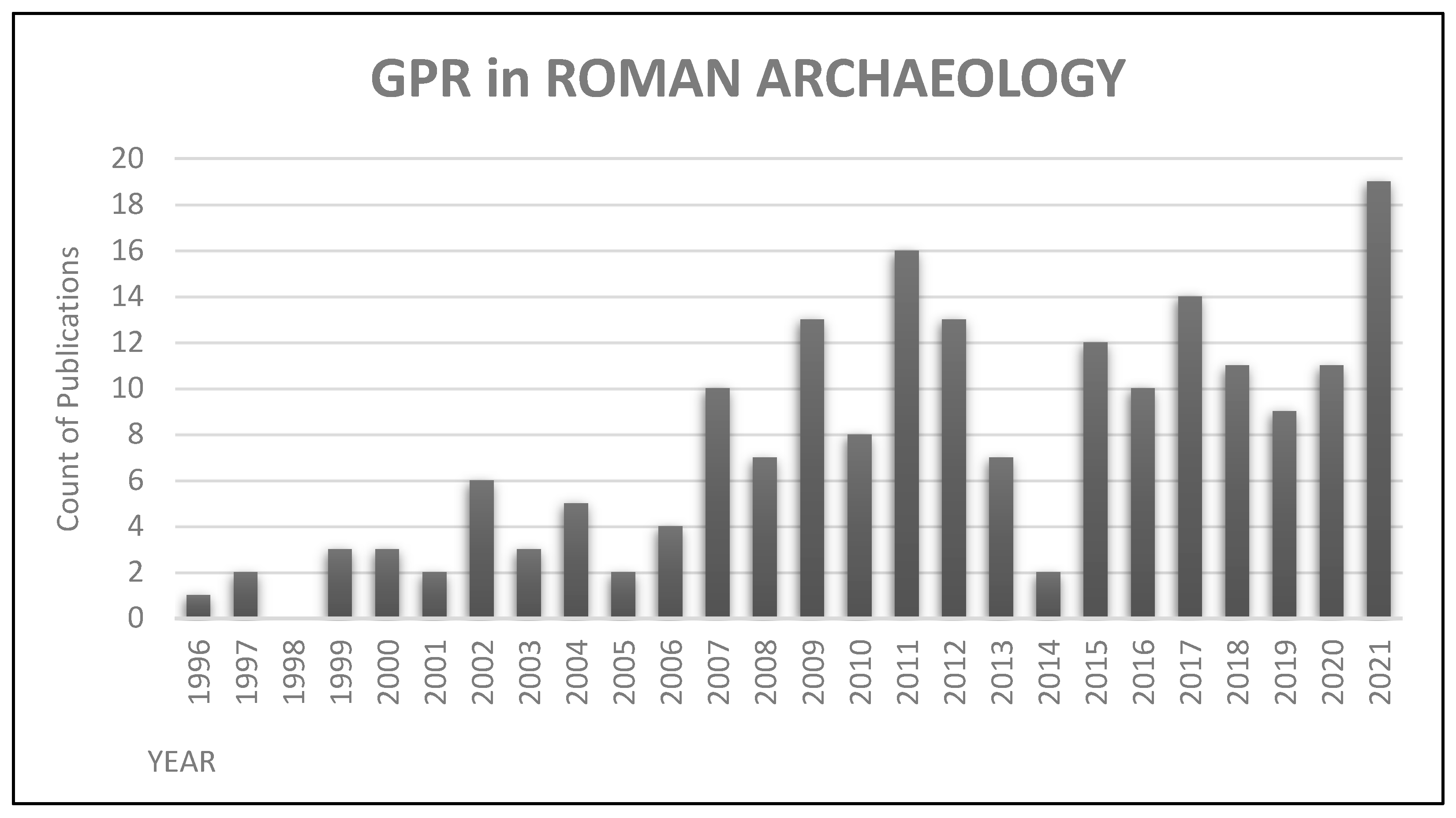
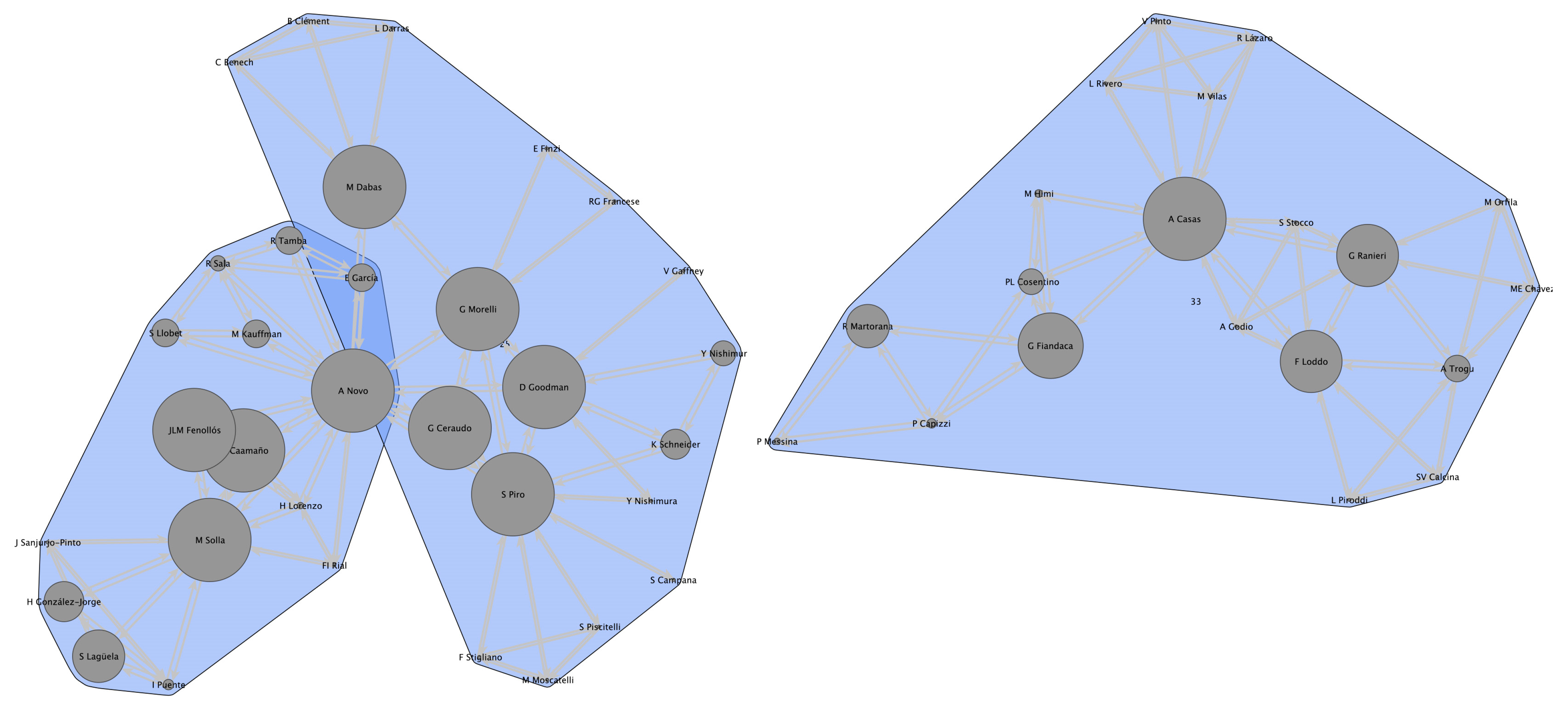
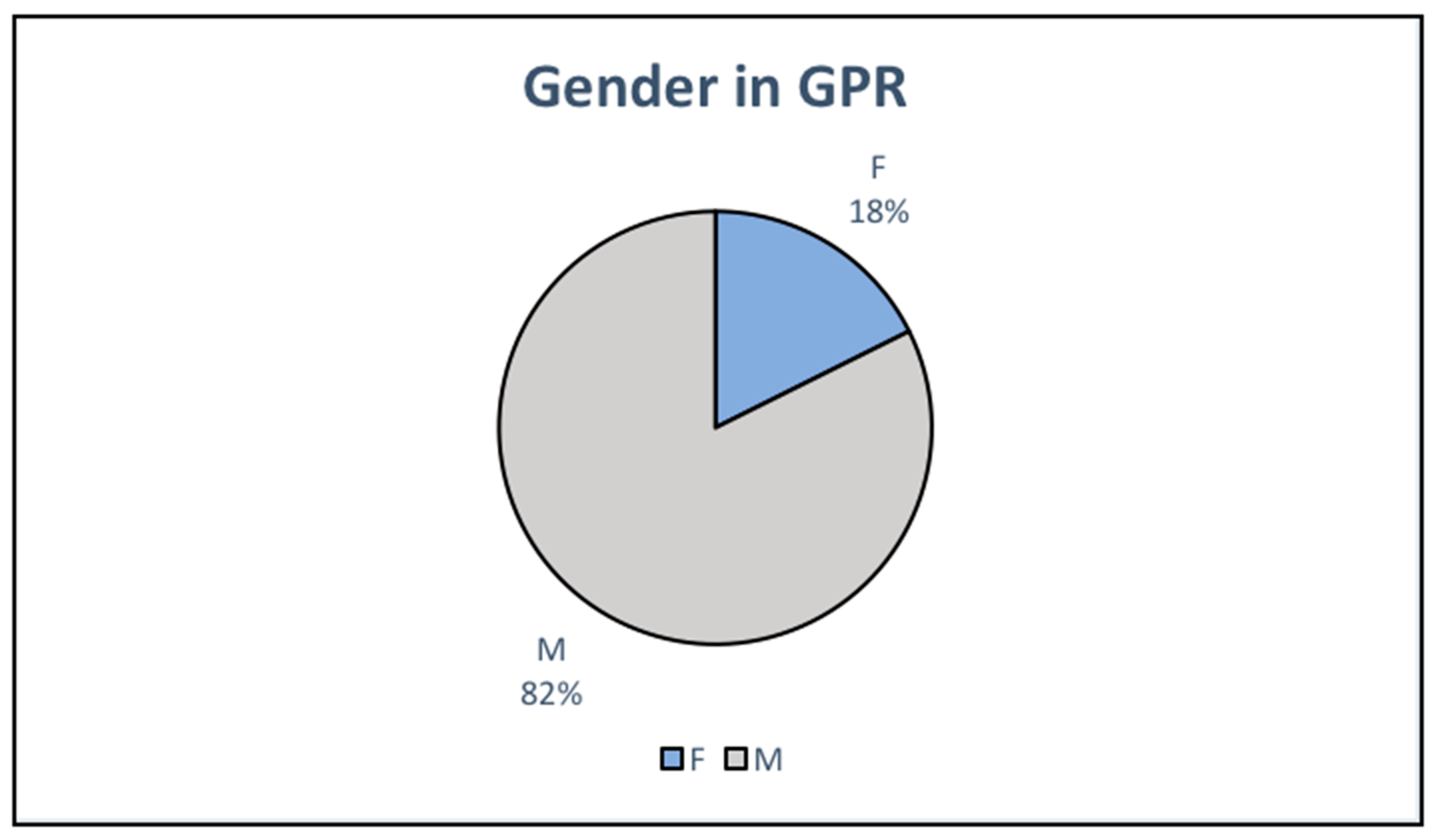
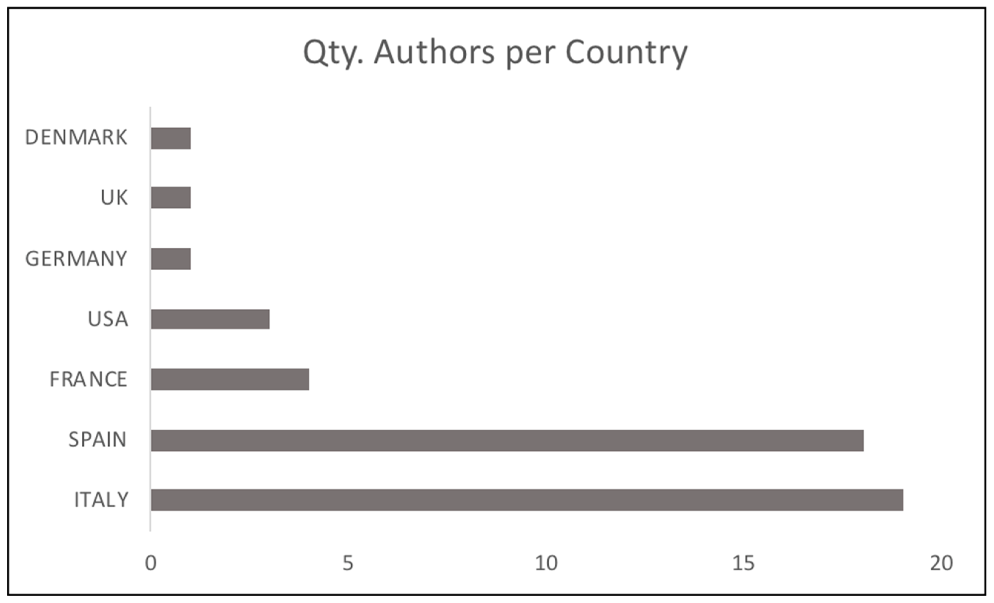
2.1. Methodology

One of the objectives of this contribution is to carry out a bibliometric analysis that allows us to monitor the dynamics and evolution of research topics linked to the use of non-invasive methods and, specifically, to the application of GPR in historical/archaeological research. Along the lines of bibliometric analysis, methods and tools have been developed that allow this type of analysis. The citations, keywords, and textual descriptors extracted from the textual body of the publications is used in this paper as a methodology based on the co-citation system.
However, it should be noted that there are limitations to this type of method [11] which must be taken into account when developing this type of analysis. One of the main limitations is the time scale set for such analyses, which can sometimes be too long to detect new research topics. However, considering this limitation and the above-mentioned h-index-centred search, it is clear that bibliographic analysis based on a co-citation methodology has obvious advantages compared to other systems [12].
Most importantly, as soon as articles are published and indexed in the database, directly related contributions highlight the evolution of an emerging research topic. As we have seen roughly in the previous sections, for the present bibliometric study, the scales of use of a non-invasive methodology in archaeology have been selected from a more general perspective to more specific fields. Differentiation based on areas of specialisation has been used as categories of association to produce a selection by co-citation for the analysis of clusters over a specific period. Thus, the outline of the bibliometric analysis developed can be summarised as follows. For the metric analysis, the use of GPR in historical/archaeological studies has been selected as an emerging theme; then, a broad chronological period has been subdivided into sub-periods based on the use of GPR by field of specialisation. A separate structural analysis has been carried out in these specialisations based on the emerging themes, the participating authors own expertise, and their collaboration on the selected theme.
In the same way, to detect emergence, the evolution of specialisations within the historical/archaeological disciplines has been monitored by observing the internal structures. Finally, linking relationships have been established between each temporal moment’s sub-structures (clusters) obtained in the first step. This last step constitutes the real core of the analysis. Over time, the change in cluster structures is assessed, and new emerging or substantially changing clusters are identified. As an added analysis to the emerging themes, identifying the main actors has been included to identify patterns of international collaboration, analysis of publication activity, and citation impact.

2.2. Results

Formal remote sensing approaches have been applied in archaeological research since the late 1960s but have only recently become widespread [13]. This trend is illustrated in Figure 1, which shows the number of research publications per year (only data from 1996 to 2021 have been selected for the use of GPR in archaeology to match the comparative application in Roman archaeology—Figure 2). The early application of GPR in archaeology was primarily dedicated to methodological articles and reviews focusing on using the techniques in archaeology. In these early publications, the methods, the anomalies recorded by the radargram, and the visualisation tools were suggested as potentially helpful methods for reviewing and analysing archaeological data [14,15,16]. Perhaps the first examples of the application of GPR to address archaeological questions in a relevant way, without focusing on methodological issues, appear reliably from the beginning of the 21st century, with examples of case studies such as Neubauer W. et al. (2002); Piro S. et al. (2003); or Campana, S. et al. (2009) [17,18,19].
This research was very influential in Roman archaeology, demonstrating great success in effectively mapping sites and extended data record capabilities of GPR. In the subsurface, the foundations and walls of destroyed Roman buildings often have strong reflection contrasts that can be detected and mapped with GPR. If we take a closer look at the applications of GPR in Roman archaeology (Figure 2), we see how the graph applied to the metrics obtained from Scopus reflects the broader trends, which increase exponentially between the years 2015 and 2021, where a large number of formal methods were introduced into multidisciplinary survey approaches [20].
Similar methods have recently been applied in different regional contexts, raising the number of examples in this ‘Roman’ speciality compared to other areas of historical/archaeological studies (Figure 3). Within the specialisation in Roman chronologies, in the period analysed (1996–2021), research in GPR seems to have focused almost exclusively on isolated publications or the result of conferences. Significantly, few authors published books dedicated to applying GPR on sites or around archaeological issues, and contributions to other research as part of a book chapter were equally rare (Table 1). This situation can be partly explained by the derivation of purely geophysical studies on case studies and the lack of full integration of the application of non-invasive methods into the historical/archaeological training. In this sense, the best example is the parallel that can be found in introducing geographic information systems (GIS) in historical studies, experiencing the same technical limitations in its beginnings. For this reason, it is exposed, as a possible cause of the interdisciplinary presence of authors of works in the beginnings of the application of GPR in archaeological analysis, where on multiple occasions, we can see how different professionals collaborate in the analysis of case studies separately, without the sufficient complementarity.
Recent years have seen GPR approaches in historical/archaeological studies explore different directions across regional contexts. Complexity-based approaches to applying GPR influenced by physics and related fields have remained popular and incredibly influential in Europe. It is possible to describe trends further using GPR in Roman chronologies through the metrics analysed. Following this, most of the studies have been applied to identify settlements or the urban layout of a site. It is a less common practice for the applications in rural case studies, and the last position is the use in the analysis of villas and the identification of their constructive spaces. Finally, we find the use of GPR in studying historical landscapes from a broader point of view. This type of analysis (Figure 3) undoubtedly, shows us the shortcomings or opportunities of applying non-invasive methodology and, precisely, the use of GPR on settlements of Roman chronology. There is also an increase in the development of original models and methods designed to address archaeological research questions. Thus, researchers are no longer exclusively adopting non-invasive techniques from other disciplines but are now actively contributing to the methodology of their application.
Returning to the global analysis of the use of GPR in our discipline through Google Scholar metrics, we see that 423 authors participated in writing the 999 publications analysed. We can explore co-authorship in this corpus of past publications by considering it a network in which authors are represented as nodes with connections defined by co-authorship. The resulting co-authorship network is shown in Figure 4 and further illustrates that co-authorship is the norm in applying GPR in antiquity studies. Furthermore, it adds to the fact that the use of this particular formal method by historians and archaeologists on an individual basis is infrequent. Collaboration with experts in the field, usually from outside the humanities, is therefore often sought. The most significant connected component includes mainly authors whose recent research output is dominated by the formal science of geophysics. Figure 4 shows, that most publications are collaborative. In this specific corpus dedicated to applying GPR in archaeology, we find 12 groups with two collaborations, 51 with more than three collaborating authors, and 8 finally representing extensive collaborations with 10 authors. These trends would corroborate the idea put forward earlier that, for most archaeologists, the use of GPR in an autonomous way is rare, being linked to a specific aspect of their research and not dominating their research output and being limited to collaboration with experts in the field, without these necessarily being professionals in the field of humanities.
The use of Louvain’s clustering method (Figure 5) [21] on the network analysis presented allows us to identify groups of authors who have more or less co-authorship between them. The two largest groups are those dominated by A. Novo and A. Casas, with several co-authors and papers in which one of these authors is a co-author. The relevance of these authors acting as a “bridge” to other co-authors is identified by the centrality measure [22] between them (represented as node size in Figure 5 and Figure 6). The two authors mentioned above are co-authors with members of different groups, which gives them a high degree-of-connectedness score with other authors. We can see how A. Novo is in a central position between two groups although sharing relevance with other authors, while A. Casas is not only positioned centrally in a group but also shows the highest ranking in the connectivity function within the collaboration. Therefore, we can interpret that the groups of authors identified with a higher connection function pursue a methodological interest in investigating the use of GPR in archaeological applications (together with their research), which leads them to be co-authors with some authors who share their methodological interests.
Using as a sample the two main clusters detected through the correlation of publications by authors, we can glimpse relevant data. In this line, the majority presence of the male gender compared to the female gender in publications related to GPR applied in archaeology is evident (Figure 7). Despite focusing on a small sample, the proportions shown are still significant, with 18% for female authors, while male authors account for 82%. Similarly, based on the interdisciplinary presence at the beginning of the application of GPR, as mentioned above, we have drawn attention to the professional profile of the researchers who make up the research groups applying GPR (Figure 8). Visualising the data obtained in the main co-authorship clusters gives us a characteristic image that seems to mark a continuity of the interdisciplinary profile detected at the beginning of applying GPR in archaeological studies. That is to say, a predominance of professionals from outside humanistic disciplines who technically support the development of specific studies. In this way, we can observe how the presence of professionals from the field of geophysics is overwhelming compared to other fields of expertise. Likewise, the specific field of ancient history is practically absent when compared with the works that use an archaeological approach to study the realities of the past, leaving a gap in the analyses that use a perspective from ancient history itself. Finally, it is worth noting that when we analyse which countries contribute to developing studies involving GPR in the knowledge of the past (Figure 9), the main clusters of co-authorship show a significant difference, with Spain and Italy at the forefront of this type of practice.

3. GPR Survey and Its Potential for Historical Studies

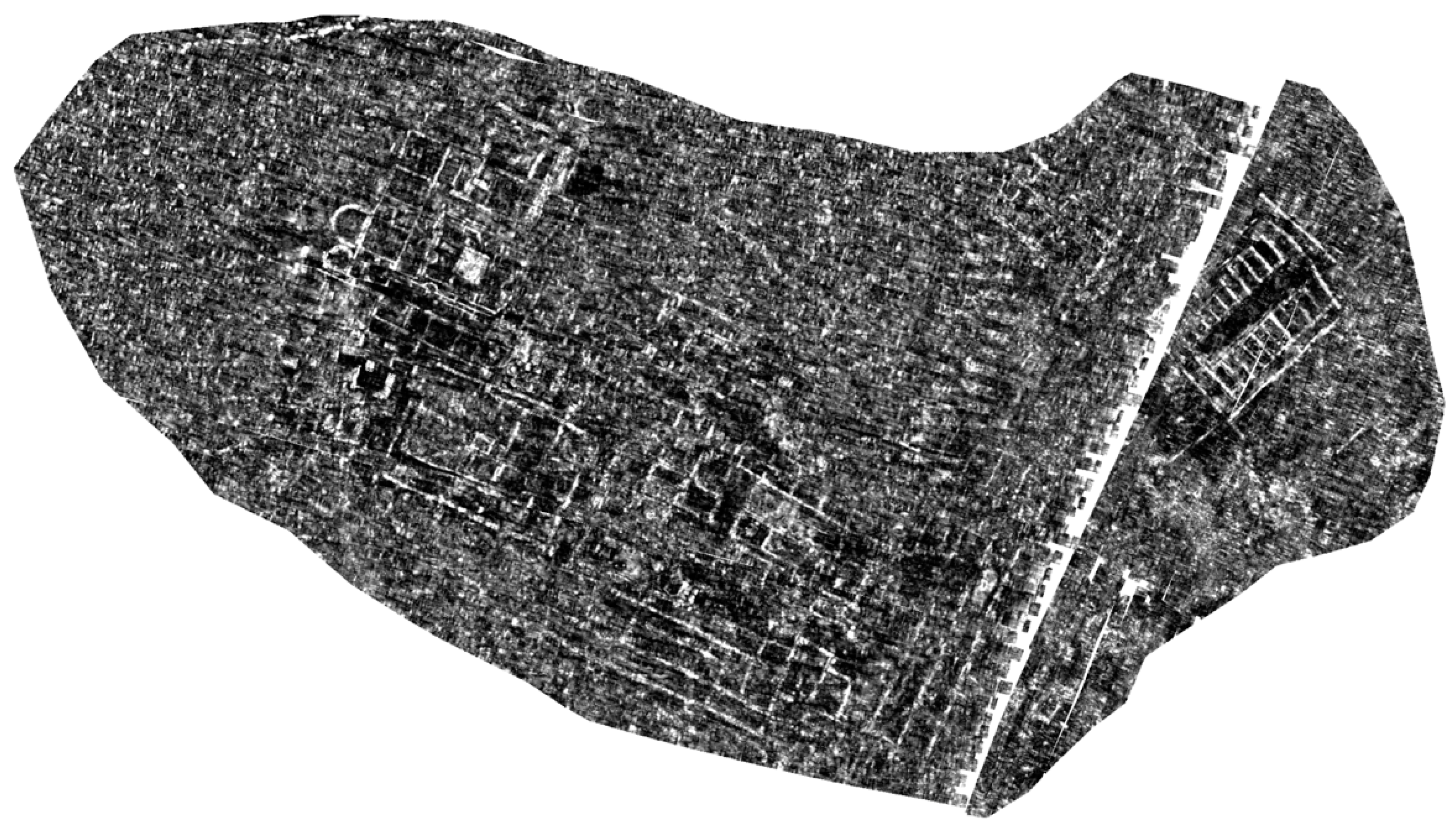
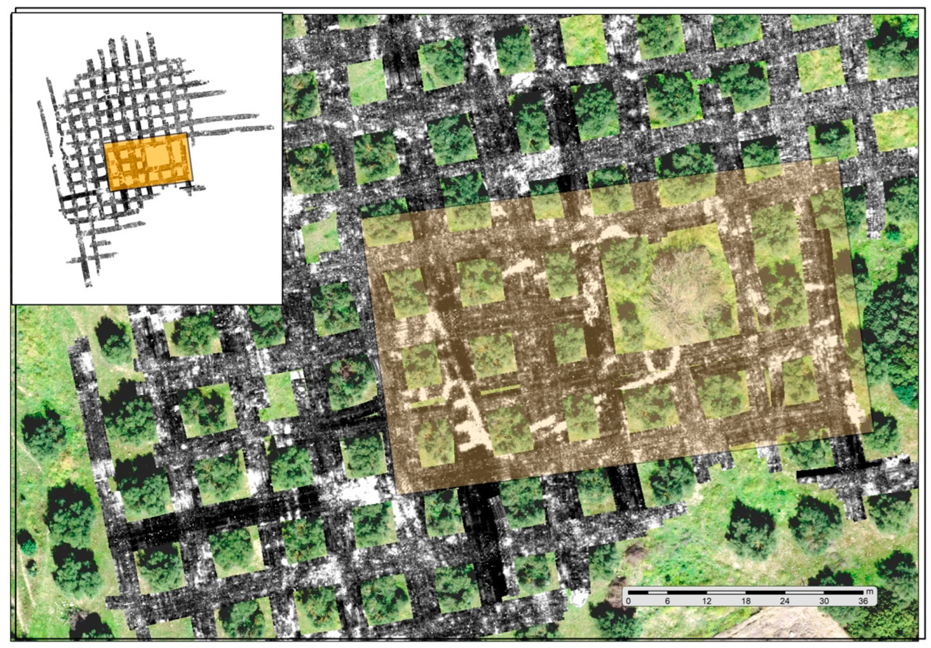
3.1. The Radargram as a Historical/Archaeological Source

The progress in applying historical/archaeological studies of methods based on advanced techniques for detecting and documenting master cultures and their digital results leads to a reflection on the definition of primary sources and their representations. Although this is not our contribution’s primary purpose, we believe initiating this debate is appropriate.
As we have indicated, the GPR technique provides valuable information for developing certain lines of research into antiquity, lines that already have a long historiographical tradition and to which recognised specialists are dedicated. However, it is striking how little impact the contributions and results of GPR surveys carried out on relevant archaeological sites have on publications from historians of antiquity. It seems important to identify the reasons for this compartmentalisation between the documentation obtained by this geophysical technique and its use by specialists in antiquity from a historical rather than an archaeological perspective.
Firstly, as detailed in previous sections, the very evolution of the technique and its application has led to it being perceived, on the one hand, as a geophysical discipline and, on the other, as a strictly archaeological discipline. The value of the results that can be obtained has not yet been generalised among historians of antiquity. Improving techniques and instruments has brought a dimension to GPR results similar to what primary historical documentation can offer. The second is because the configuration of the research groups that incorporate the technique in their projects and the leadership of these teams made the development of geophysical surveys, generally, a collaborative work, requiring specific instruments and specialised technicians. This scenario implies a significant investment in infrastructure and qualified training. The model developed in Europe in recent decades, due to these same circumstances—investment and specialisation—has been linked to universities or research institutes of particular importance and capacity.
There are a number of prominent centres specialised in historical/archaeological research rather than in geophysical application in general. Some but not all of them are the Ludwig Boltzmann Institute for Archaeological Prospection and Virtual Archaeology, Vienna; the Foundation for Research and Technology, Hellas (F.O.R.T.H.); the Laboratory of Landscape Archaeology and Remote Sensing at the University of Siena; the Unidad de Geodetección y Georeferenciación del Patrimonio Histórico-Arqueológico, IVAGRO, Universidad de Cádiz; PATRICIA: Unidad de Investigación, Innovación y competitividad para el medio Patrimonial, Universidad de Córdoba; the Geoarchäologisches Labor des Vorgeschichtlichen Seminars, Philipps University of Marburg; or the MINARQLAB-Laboratorio de Arqueología no Invasiva, Instituto de Arqueología de Mérida, CSIC. The management of these specialised teams (together with others not mentioned in this paper for space reasons) has rarely been linked to the areas of knowledge of ancient history but usually to the fields of geophysics and archaeology. This situation contributes to the separation that exists between the results this kind of innovative methods, potentially useful for ancient history and the academics who really represent this field. It is also interesting to highlight the fact that many of these groups that are currently contributing to the field appear underrepresented within PoP analysis.
Moreover, the products obtained, once they have undergone the necessary post-processing in the laboratory, even though they are digital products, can and usually are presented as analogue results through publications. However, the conversion of digital and three-dimensional archaeological data, with all the potential for analysis that this entails, into analogue formats limits the historical analysis that can be made of the results. Even so, the resulting maps from geophysical surveys at archaeological sites are not usually considered at the same level as the maps derived from traditional excavations, an essential source in studying ancient urban layouts and public and private spaces within rural and urban contexts. To a large extent, this circumstance can be explained by the lack of utilisation of geographic information systems (GIS) by many historians of antiquity. GIS is an essential tool for correctly treating and analysing digital and georeferenced cartographic products created by GPR techniques.
As a result of the causes described above, such as the non-identification of GPR exploration as a methodology specific to historians, the lack of involvement of ancient historians in the leadership of teams specialised in non-invasive techniques, the lack of predisposition in certain areas of knowledge to the analysis of digital sources and the use of GIS, the perception that the information provided by geophysical equipment such as GPR is not considered as a source that can be analysed from the perspective of historians’ competences. It can be concluded that, as a general rule, the documentary products offered by modern geophysical equipment are not perceived and recognised by specialists studying antiquity as a primary source, at least not on the same level of recognition as cartography derived from traditional archaeological excavations. Because of this, the need to characterise and recognise the results of the GPR surveys as a record of a primary historical source is argued. In this sense, this information should be considered an essential step to revitalise research in lines of study that today can be considered a priority. For example, identifying ancient urban layouts is understood as a form of historical expression of the occupation, management, and uses of the territory and landscape.
As is well known to specialists, modern multi-channel GPR equipment and the software developed for processing the results provide an accurate three-dimensional image of the archaeological space explored. Although the optimum depth ranges for the visualisation of these results do not generally exceed −2.5 metres in depth, the information provided can be of high quality, as well as allowing, as a digital product, a detailed analysis in plan and longitudinal and transversal profiles, i.e., three-dimensionally, of all detected anomalies that correspond to structural archaeological remains, regardless of their nature.
The data obtained from the diverse process described above is analysed, processed, and put under evaluation of the necessary historical criticism. It is necessary to highlight then that the mapping resulting from this type of exploration should be considered as a representation of a source of primary information, as reliable, as the one provided by a traditional archaeological intervention. Further, it contributes to the advantages of its potential three-dimensional analysis, its georeferenced nature, and the preservation of the original state of the archaeological site under study. Precisely therein lies one of the advances achieved in the GPR application, and that is that the skills required for the interpretation of these planimetric models are no longer, neither primarily nor preferably, those of geophysicists but those of historians and archaeologists specialised, in this case, in the classical world. Thus, for example, the explorations we have carried out at the site of El Carrascal (Figure 10) are related to the problem of the location of the municipality of Flavia Sabora, a new city established in the time of Vespasian. The image obtained can be analysed by historians, and from the current knowledge about the urban patterns of the Flavian period, identify its architectural elements and confirm or refute the identification of the site with the foundation of the last third of the first century AD.
It can be argued that the field has witnessed an advance in methodology based on technology and new instruments without alteration of the epistemology of our disciplines when resorting to the use of GPR but instead has accomplished the strength and reactivation of the discipline, acquiring new sources of information of great qualitative and quantitative value.
It is the historical analysis of the product obtained, in its archaeological context, with the help of previous historiographic knowledge and the help of other primary sources, which can turn the radargram into a primary source, as if the information came from a site that has already been excavated. Our historically based interpretation of the mapping obtained by geophysical methods, even if they are considered, in the author’s opinion, a primary source, still retains a margin of hypothesis. They can be discussed and interpreted differently, but in the same way that the interpretation of an archaeological site published by its excavators can be discussed, or the interpretation of a literary or epigraphic source, which has been historically analysed, can be disagreed with diverse arguments.
It can be objected that there are limitations to the results provided by the GPR survey, e.g., that the quality of the data depends on somewhat random natural factors, such as the environmental, orographic, or lithological conditions of the area under study. Additionally, methodological strategies limit the results of the survey. These circumstances may be comparable to traditional archaeological practice, i.e., the state of conservation and the physical characterisation of the archaeological elements condition the result of the intervention, or that not all teams, projects or researchers base their projects on the same level of methodological quality. Therefore, the valuation of the data must be based on the quality of its collection, whether conditioned by the context of the study or the methodology applied. Once these two conditions have been positively assessed, there is nothing to prevent us from analysing the results regarding their veracity and reliability.
It is also reasonable to consider that the data may lack information to help characterise the detected materials and their dating. Nevertheless, it is also true that technical advances in the equipment used show an increasing ability to define anomalies and provide quantitative information concerning the nature of the response of archaeological materials to the pulses emitted and the responses received. Another objection derives from the inability of the geophysical results to determine the chronologies of the elements detected. However, the possibility of combining the results with other techniques allows these shortcomings to be at least partially overcome. We are referring to surface surveys, whether extensive or micro-surface (Figure 11).
A preliminary assessment of the life of a settlement based on the analysis of the material culture documented on the surface is part of the usual archaeological skills. When we also have the possibility of georeferencing the position of archaeological artefacts and relating them to the construction spaces detected by the GPR, the possibility of dating and identifying phases of occupation in settlements based on geophysical readings increases [23].
On the other hand, in terms of stratigraphic analysis, the possibilities of the GPR data offered visually interpolated in plan and individualised in longitudinal and transversal profiles or exported three-dimensionally as point clouds seem to us to be very relevant. We are in a position to characterise the archaeological anomalies detected in all their dimensions stratigraphically, establishing their structural relationships, both in plan and in elevation, making it possible to conclude the urban configuration of the settlement studied and often determining different occupational phases that may concur in the diachrony of a settlement [24]. It is possible to establish preliminary archaeological readings of the main stratigraphic features detected by the GPR, at least in the first few metres of the explored subsoil (Figure 12).
In addition to stratigraphic analysis, a building plan obtained using the GPR method can be studied using the skills of historians of antiquity, with the help of Greco-Latin literary sources, to establish hypotheses about its categorical identification, functionality, and chronologies. The geophysical equipment does not provide this information directly. However, the knowledge of cultural practices deduced from the literary information is vital in carrying out this analysis and establishing historical hypotheses that lead to interpreting the spaces explored, as a whole and in their contexts, is explained next.
As we have been arguing, the extension of the use of geo-radar has made it possible to revitalise new lines of research whose frontiers of knowledge have been heavily conditioned by the practice of traditional archaeology and the characteristics of the information it provides. Among these lines, we wanted to highlight and exemplify the potential of two of them: first, those related to the study of the ancient city and second, the study of rural settlements. For the academic reactivation of these lines of study to occur, the research community must recognise the representative character of the results of GPR surveys as a primary source. In the same way, it is possible to postulate for other geophysical techniques. Moreover, this synergy between the use of GPR and the revitalisation of long-standing lines of research derives from the versatility of the technique for use in many spatial contexts, subject to varied geographical conditions, from its potential to explore large surface areas in very reasonable times and at very reasonable costs and from the relative speed with which we can access the results of the explorations. In our presentation, we will focus on the cases of study from Hispania, resorting to published explorations, being aware that much of geophysical work carried out in recent decades has not been made public through the usual academic formats [25].

3.2. The Study of the City and Ancient Urban Layout

The study of ancient urban planning is one of the most traditional lines of research in the historiography of antiquity. Its importance derives from the civic and urban nature of the development of the great ancient cultures of the Mediterranean. In the case of Rome, the role played in the social and political structure of the empire by the civitas as a civic community and the urbs, as an architectural and urban expression of that historical reality, is evident, transcending the Italic experiences to the geographical whole of the imperial construction. Obviously, the formae urbes were not an immutable reality but underwent their own processes of transformation and adaptation which responded to historical changes and which can help the researcher to identify the chronological framework of the construction under study.
The study of the ancient city was initially based on the exegesis of written sources, with notable contributions to understanding Greco-Roman culture [26]. Much outstanding urbanistic research is based on literary and epigraphic information and archaeological information, such as the encyclopaedic works of A Topographical Dictionary of Ancient Rome and the Lexicon Topographicum Urbis Romae and its supplements [27,28], to cite a few paradigmatic contributions. From the point of view of the archaeological analysis of urban parcels and various urban elements, there have also been many contributions, such as those collected in the collection Atlante Tematico Di Topografia Antica, published since 1990, by Stefania Quilici Gigli and Lorenzo Quilici, [27] which, in the authors’ opinion, is an excellent example of research based on archaeological and geographical information.
Nowadays, the number of ancient cities whose urban planning is known thanks to geophysical methods is increasing considerably [29,30,31,32,33]. For example, in the case of the provinces of Hispania, we can highlight in Lusitania, Ammaia [34,35,36], and Balsa [37]; in Baetica, Arva [38], Carissa Aurelia, and Hasta Regia [39]; and in Tarraconensis, Emporiae [40], Libisosa, Ilici, and Segisamo [41]. Other cases of cities in Hispania well known through geophysical techniques have not been using GPR but magnetometry, as is the case of Ategua, Contributa Iulia, and Regina Turdulorum [42,43,44].
The analysis of ancient cities through the classical archaeological method faces several difficulties, some of which can be overcome thanks to current geophysical instruments. For example, the primary constraint is the time required for the exhumation of the archaeological remains, which requires many years of work campaigns to achieve a complete urban visualisation of a given city, as we have already mentioned. The speed of data collection and interpretation provided by the GPR technique, and its reasonable costs, make it possible to somewhat overcome this handicap of traditional research.
The second problem identified is the overlapping urban layouts. This fact is a prevalent characteristic in Mediterranean contexts with long urban tradition. It can be seen in the documentation of different urban phases on the same site implies an additional complexity in the excavation and the correct interpretation of the archaeological remains, with stratigraphic levels which, at the same time, are being destroyed by the excavation process. These contexts mean an additional difficulty in understanding the processes of genesis, development, growth, reorganisation, or contraction of the urban nucleus, a difficulty, in short, in understanding their historical evolution. In the case of 3D GPR studies, the possibility of analysing the results by stratigraphic packages allows for identifying different stages in the building life of a city, although, logically, this potential is still conditioned by the penetration capacity and the quality of the signal resolution of the equipment at depths of more than 2.5–3 m (Figure 13).
Other circumstances hindering traditional archaeological analysis are related to topographical conditions or current land uses. The former often conceal the original foundations of ancient cities and their adaptation to the physical environment, which in specific geographical contexts do not respond to pre-established canons. Concerning the latter, when, for example, we find ourselves in former tree plantations (fruit orchards, olive groves, vineyards), the development of archaeological activities interferes with the local economy and presents many problems in terms of research logistics. As in previous cases, our experience in the study of settlements with these geographical and productive conditions [45] confirms the improvement in obtaining historical information using GPR combined with other current techniques (LiDAR, Magnetometry) (Figure 14).
As we have been arguing, the analysis of urban layout maps obtained using geophysical techniques must be based on the historical/cultural principles that govern urban evolution in the framework of antiquity, which in turn derive essentially from the exegesis of Greco-Latin sources, especially books V and VI of De Architectura by Vitruvius. Most of the contributions to date have been merely descriptive analyses of the results of geophysical explorations of urban settlements, without making any real contribution to the historical analysis of the processes that affect ancient urban planning. In this sense, we consider it necessary to connect classical literary sources and historical analytical perspectives with the information provided by GPR surveys. Within this approach, it is essential to incorporate urbanistic aspects relating to the proportion, orientation and dimensions of urban contexts as historical and cultural features into the analysis. In the same way, it is appropriate to analyse the characteristics of architectural elements in depth. This analysis can be made by paying attention to the ancient cities’ diachronic elements, the evolutionary features related to the changes in the Latin civitates, and the various juridical expressions reflected in their urban physiognomy. Furthermore, this analysis can be completed by observing the connection with the various pre-existing cultural traditions in the later provincial territories, which generated regional adaptations that must also be studied.

3.3. The Study of Rural Settlements and Agricultural Organisation

Inherent to the city’s importance in territorial planning is the role of the secondary settlements, related to the occupation, planning, and use of agriculture dependent on the city, the villae, and other types of establishments typical of rural areas. The problem of rural settlements, expressed by the empire’s geographies in very diverse ways, constitutes another line of research with a long historiographical tradition. These contexts are another of the great beneficiaries of the incorporation of non-invasive techniques into the methods of historical/archaeological documentation, as it can be promoted thanks to the contribution of abundant unpublished information obtained with geophysical methods.
Studies on the ancient rural world have been based on analysing agronomic literary sources and traditional archaeological practice, into which techniques such as extensive surface prospecting or analyses derived from aerial remote sensing of their vestiges have been incorporated. As in the case of cities, ancient secondary settlements have been preferred areas for geophysical research.
The GPR survey of rural settlements makes it possible to understand their building organisation without the need for lengthy traditional excavation campaigns. It allows the historian’s skills to analyse the different phases of occupation and the constructive modifications undergone by a given settlement [46]. It is also an effective tool to help solve the problem of the diversity and polymorphism presented by the establishments linked to the rural space, which do not necessarily relate exclusively to agricultural activities, such as buildings related to the road network [47], to the concentration and distribution of surpluses, to territorial control or even to the symbolic landscape.
Although most of geophysical explorations carried out in this area have focused on the partes urbanae and fructuariae of the villae [24], no less attractive is the application to the pars rustica to understand better elements of the fundus related to other aspects of the villa, such as the actual limits of the fundus, its internal communications, and, especially, its agricultural plantations, in this case through the study of the relict plantation frames of, for example, olive groves and vineyards [48,49,50].
Among the challenges that concern the study of the villa system in Hispania and which can be tackled with non-invasive techniques, those related to the knowledge of its establishment and constructive evolution stand out. These originated in the late Republican period, with establishments that did not completely lose their role of strategic territorial control, maintaining their legionary imprint while at the same time deploying the exploitation of the territory’s agricultural resources. The expansion of the villas in Early Imperial times, with a gradual occupation of the Hispanic geography, must have been due to the importation of Italic architectural models with diverse regional influences. The extension of the known cartographies of the pars urbana of the villae, which allows the use of GPR, can answer the questions posed in this sense, establishing relationships between the Hispanic models and their Italic influences. On the other hand, the evolution of rural buildings over time, the transformations they underwent, especially in periods of crisis and instability, and, finally, the rise of the so-called late-Roman aulic villae are historical phenomena closely linked to the history of the rural world, which can be revisited with the help of GPR techniques.
In the case of Hispania, regarding the application of the GPR technique and the publication of its results, the following examples can be highlighted: in Lusitania, the villa of Orta da Torre in Fronteira [51]; in Baetica, the rural settlement of Miramundo in Puerto Real, Cádiz [23]; in Tarraconensis, the surroundings of the villa of Almenara de Adajas [52].

4. Conclusions

Although the use of GPR in particular, and geophysical methods in general, in one form or another, have a long history in archaeology, it is only recently that we have been able to begin to draw the boundaries of this emerging sub-discipline. Archaeologists, in particular, have traditionally absorbed the methodological advances that other fields could offer. Moreover, in the case of geophysics, the first experiences on archaeological sites can be traced back to the middle of the 20th century. Since the early 2000s, the growing interest in interdisciplinary teams has fuelled a new boom in historical/archaeological research. Advances in computer software and the increasing availability of large databases have undoubtedly contributed to the current boom in research into applying non-invasive methods to historical/archaeological questions. However, the review developed in this paper suggests that there are factors to consider that may help the development of this specialisation, particularly from the point of view of the analysis of historical contexts directly linked to antiquity.
Perhaps as a sign of the maturing of the sub-discipline, we can see that specialised groups have emerged that combine expertise in techniques such as GPR and historical and archaeological training background. However, there is still a clear need to valorise GPR data and other non-invasive methods as primary sources. Although many researchers and teams are increasingly resorting to geophysical models and methods such as GPR to address social science questions from archaeological data, it is necessary to emphasise that this methodology can reactivate traditional lines of historical research. Although these approaches are now spreading to different fields within archaeology itself, the results of GPR exploitation are still predominantly descriptive. Moreover, it is still rare to find their application in the field of historical research itself. In a young sub-discipline such as this, we see these divergent approaches positively as potential sources of innovation. The bibliometric study presented here paints a picture of a field driven by several complementary processes. The co-authorship analysis shows that a few researchers and research teams have devoted much effort to developing and applying archaeology. However, there are also many researchers whose field of expertise is more closely linked to geophysics than to history or archaeology itself. This reality is reminiscent of similar trends in GIS applications to archaeology in the 1990s and early 2000s.
Finally, the potential that GPR can have in discussing case studies focused on both urban and rural contexts in antiquity has become clear, allowing for deepening the data from a perspective that considers the final products of these techniques as interpretative primary sources. The various products resulting from GPR, whether in urban or rural contexts, can help understand historical phenomena of the past that can be contrasted with traditional sources such as the classical authors themselves. Historians and archaeologists interested in establishing the application of geophysical methods as a key tool for exploring social change will have a better chance of success to the extent that they actively collaborate. Additionally, it will help to share a complementary discourse of results that will allow this type of more innovative studies to be adopted within traditional discourses.

Supplementary Materials

The following supporting information can be downloaded at: https://www.mdpi.com/article/10.3390/land12061165/s1, Table S1: Google Scholar and Scopus GPR in archaeology index summary used for this article.

Author Contributions

Conceptualisation, L.G.L.-B. and E.A.-N.; methodology, L.G.L.-B. and E.A.-N.; formal analysis, L.G.L.-B. and E.A.-N.; investigation, L.G.L.-B. and E.A.-N.; writing—original draft preparation, L.G.L.-B. and E.A.-N.; writing—review and editing: All authors have read and agreed to the published version of the manuscript.

Funding

No funding was required for this research.

Data Availability Statement

The authors confirm that the data supporting the findings of this study are available within the article [and/or] its supplementary materials.

Conflicts of Interest

The authors declare no conflict of interest. The funders had no role in the design of the study; in the collection, analyses, or interpretation of data; in the writing of the manuscript; or in the decision to publish the results.

References

  1. Harzing, A.W. Publish or Perish, 2007. Available online: https://harzing.com/resources/publish-or-perish (accessed on 3 May 2022).
  2. Bi, H.H. Four problems of the h-index for assessing the research productivity and impact of individual authors. Scientometrics 2023, 128, 2677–2691. [Google Scholar] [CrossRef]
  3. Barone, P.M. Understanding Buried Anomalies: A Practical Guide to GPR; LAP Lambert Academic Publishing: Saarbrücken, Germany, 2016. [Google Scholar]
  4. Berard, B.A.; Maillol, J.-M. Multi-offset ground penetrating radar data for improved imaging in areas of lateral complexity—Application at a Native American site. J. Appl. Geophys. 2007, 62, 167–177. [Google Scholar] [CrossRef]
  5. Böniger, U.; Tronicke, J. Improving the interpretability of 3D GPR data using target–specific attributes: Application to tomb detection. J. Archaeol. Sci. 2010, 37, 672–679. [Google Scholar] [CrossRef]
  6. Conyers, L.B. Interpreting Ground-Penetrating Radar for Archaeology; Left Coast Press: Walnut Creek, CA, USA, 2012. [Google Scholar]
  7. Ernenwein, E.G.; Kvamme, K.L. Data processing issues in large-area GPR surveys: Correcting trace misalignments, edge discontinuities and striping. Archaeol. Prospect. 2008, 15, 133–149. [Google Scholar] [CrossRef]
  8. Ewen, C.R. The role of GPR in archaeology: A beginning not an End. North Carol. Archaeol. 2016, 65, 92–99. [Google Scholar]
  9. Goodman, D.; Piro, S. GPR Remote Sensing in Archaeology; Springer: New York, NY, USA, 2013. [Google Scholar]
  10. Leckebusch, J. Ground-penetrating radar: A modern three-dimensional prospection method, Archaeol. Prospect 2003, 10, 213–240. [Google Scholar] [CrossRef]
  11. Hicks, D. Limitations of Co-Citation Analysis as a Tool for Science Policy. Soc. Stud. Sci. 1987, 17, 295–316. [Google Scholar] [CrossRef]
  12. Glänzel, W.; Czerwon, H.J. A new methodological approach to bibliographic coupling and its application to the national, regional and institutional level. Scientometrics 1996, 37, 195–221. [Google Scholar] [CrossRef]
  13. Lerici, C.M. Prospezioni geofisiche nella zona archeologica di Vulci. In Alla Scoperta delle Civiltà Sepolte. I Nuovi Metodi di Prospezione Archeologica; Lerici Publishers: Milano, Italy, 1960. [Google Scholar]
  14. Fisher, E.; McMechan, G.A.; Annan, A.P. Acquisition and processing of wide-aperture ground-penetrating radar data. Geophysics 1992, 57, 495–504. [Google Scholar] [CrossRef]
  15. Nawawi, M.N.M.; Abdullah, M.Z. Application of geophysical methods for quantitative archaeological investigations. In SEG Technical Program Expanded Abstracts 1996; Society of Exploration Geophysicists: Houston, TX, USA, 1996; pp. 770–773. [Google Scholar]
  16. Seren, S.S. Ground penetrating radar (GPR) as a powerful tool in archaeological prospection. In Proceedings of the 4th EEGS Meeting, Barcelona, Spain, 14–17 September 1998; European Association of Geoscientists & Engineers: Utrecht, The Netherlands, 1998; p. cp-43. [Google Scholar]
  17. Neubauer, W.; Eder-Hinterleitner, S.A.; Seren, P.M. Georadar in the Roman civil town Carnuntum, Austria: An approach for archaeological interpretation of GPR data. Archaeol. Prospect. 2002, 9, 135–156. [Google Scholar] [CrossRef]
  18. Piro, S.; Goodman, D.Y.; Nishimura, Y. The study and characterisation of Emperor Traiano’s villa using high-resolution integrated geophysical surveys. Archaeol. Prospect. 2003, 10, 1–25. [Google Scholar] [CrossRef]
  19. Campana, S.; Piro, S. Seeing the Unseen: Geophysics and Landscape Archaeology; CRC Press: Delft, The Netherlands, 2009. [Google Scholar]
  20. Okamura, K. Interdisciplinarity revisited: Evidence for research impact and dynamism. Palgrave Commun. 2019, 5, 1–9. [Google Scholar] [CrossRef]
  21. Blondel, V.; Guillaume, J.; Lambiotte, R.; Lefebvre, E. Fast unfolding of communities in large networks. J. Stat. Mech. Theory Exp. 2008, 10, P10008. [Google Scholar] [CrossRef]
  22. Collar, A.; Coward, F.; Brughmans, T.; Mills, B.J. Networks in Archaeology: Phenomena, Abstraction, Representation. J. Archaeol. Method Theory 2015, 22, 1–32. [Google Scholar] [CrossRef]
  23. Lagóstena, L.; Ruiz Gil, J.A.; Martín Mochales, D.; Pérez Marrero, J.; Rondán-Sevilla, I.; Trapero Fernández, P.; Catalán González, F.J.; Ruiz Barroso, M. El establecimiento rústico alto-imperial de Miramundo (Puerto Real, Cádiz). Un caso de estudio mediante combinación de técnicas de investigación no invasivas. In Estudos Arqueológicos de Oeiras 29; Câmara Municipal: Oeiras, Portugal, 2021; pp. 57–64. [Google Scholar]
  24. Lagóstena, L.; Molina, J. La “figlina” como ámbito de investigación cuantitativa de la economía romana: Aportación y potencial de la exploración georradar. In Ex Baetica Romam. Homenaje a José Remesal Rodríguez; Universidad de Alicante: San Vicente del Raspeig, Portugal, 2020; pp. 923–946. [Google Scholar]
  25. Brito, P.; Carreras, C. Aplicación de métodos geofísicos en arqueología: Una recopilación sobre el actual estado de la cuestión en España. Sci. Herit. 2005, 1, 1–20. [Google Scholar]
  26. De Coulanges, F. La Cité Antique; Barnes & Noble: París, France, 1864. [Google Scholar]
  27. Platner, S.B.; Ashby, T. (Eds.) A Topographical Dictionary of Ancient Rome; Oxford University Press: Oxford, UK, 1929. [Google Scholar]
  28. Steinby, E.M. (Ed.) Lexicon Topographicum Urbis Romae; AbeBooks: Roma, Italy, 2000. [Google Scholar]
  29. Quilici Gigli, S.; Quilici, L. (Eds.) Atlante Tematico Di Topografia Antica; L’Erma di Bretschneider: Roma, Italy, 1990. [Google Scholar]
  30. Dirix, K.; Muchez, P.; Degryse, P.; Kaptijn, E.; Music, B.; Vassilieva, E.; Poblome, J. Multi-element soil prospection aiding geophysical and archaeological survey on an archaeological site in suburban Sagalassos (SW-Turkey). J. Archaeol. Sci. 2013, 40, 2961–2970. [Google Scholar] [CrossRef]
  31. Gaffney, V.; Patterson, H.; Piro, S.; Goodman, D.; Nishimura, D. Multimethodological approach to study and characterise Forum Novum (Vescovio, Central Italy). Archaeol. Prospect. 2004, 11, 201–212. [Google Scholar] [CrossRef]
  32. Keay, S.; Earl, G.; Hay, S.; Kay, S.; Ogden, J.; Strutt, K.D. The role of integrated geophysical survey methods in the assessment of archaeological landscapes: The case of Portus. Archaeol. Prospect. 2009, 16, 154–166. [Google Scholar] [CrossRef]
  33. Verdonck, L.; Launaro, A.; Vermeulen, F.; Millett, M. Ground-penetrating radar survey at Falerii Novi: A new approach to the study of Roman cities. Antiquity 2020, 94, 705–723. [Google Scholar] [CrossRef]
  34. Goodman, D.; Piro, S.; Nishimura, Y.; Patterson, H.; Gaffney, V. Discovery of a 1st century AD Roman amphitheater and other structures at the Forum Novum by GPR. J. Environ. Eng. Geophys. 2004, 9, 35–41. [Google Scholar] [CrossRef]
  35. Vermeulen, F.; Corsi, C. Ammaia I: The Survey. A Romano-Lusitanian Townscape Revealed; ARGU: Ghent, Belgium, 2012; Volume 8. [Google Scholar]
  36. Corsi, C.; Vermeulen, F. Ammaia and the making of a roman town: A contribution to urbanism studies in Lusitania. In Proceedings of the XVIII CIAC: Centro y Periferia en el Mundo Clásico/Centre and Periphery in the Ancient World, S. 14. Iberia y Las Hispaniae Iberia and the Hispaniae, Mérida, Spain, 13–17 March 2013; pp. 1741–1746. [Google Scholar]
  37. Verdonck, L.; Taelman, D.; Corsi, C.; Vermeulen, F. Ground Penetrating Radar at Ammaia. In AMMAIA I: The Survey. A Roman Lusitanian Townscape Revealed; Academia Press: Ghent, Belgium, 2012; pp. 69–81. [Google Scholar]
  38. Bernardes, J.P.; Rondán-Sevilla, I.; Candeias, C.; Ruiz, M. Non-Invasive Prospection Methods in the Roman City of Balsa (Luz de Tavira-Portugal): Revealing the Real Townscape. Land 2022, 11, 1785. [Google Scholar] [CrossRef]
  39. Lagóstena, L.; Ruiz Gil, J.A.; Pérez-Marrero, J.; Trapero, P.; Catalán, J.; Rondán, I.; Ruiz-Barroso, M. Three coloniae and three municipia: Non-invasive exploration of urban contexts in Roman Hispania. In Proceedings of the Non-Intrusive Methodologies for Large Area Urban Research. Roman Transformed Conference, Almeria, Spain, 1–2 July 2021. In Press. [Google Scholar]
  40. Novo, A.; Sala, R.; Morelli, G.; Leckebusch, J.; Tremoleda, J. Full wave-field recording: STREAM X at Empuries (Girona, Spain). In Proceedings of the Archaeological Prospection—9th International Conference, Izmir, Turkey, 19–24 September 2011; pp. 213–217. [Google Scholar]
  41. García Sánchez, J.; Costa-García, J.M. Teledetección y prospección geofísica en Veladiez. Un sector inédito de la ciudad romana de Segisamo (Sasamón, Burgos). Cuad. Lab. Xeológico Laxe 2021, 43, 41–60. [Google Scholar] [CrossRef]
  42. Fuertes Santos, M.C. Lo que la tierra esconde. La ciudad romana de Ategua, Córdoba. In Small Towns, Una Realidad Urbana En La Hispania Romana; Mateos, P., Olcina, M., Pizzo, A., Schattner, T.G., Eds.; Instituto de Arqueología de Mérida: Mérida, Spain, 2022; Volume 2, pp. 445–458. [Google Scholar]
  43. Mateos Cruz, P.; Pizzo, A.; Mayoral Herrera, V. El paisaje urbano de Contributa Iulia Ugultunia (Medina de la Torres, Badajoz). Ciudad. Romanas Extremad. Stud. Lusit. 2014, 8, 113–133. [Google Scholar]
  44. Álvarez Martínez, J.M.; Iglesias Gil, J.M.; Jiménez Chaparro, J.I.; Teichner, F. Prospecciones geofísicas en Regina Turdulorum (Casas de Reina, Badajoz). Aplicación al conocimiento de su territorio urbano. In Proceedings of the La Revalorización de Zonas Arqueológicas Mediante el Empleo de Técnicas no Destructivas: Reunión Científica, Mérida, Badajoz, Spain, 12–13 June 2014; coord. por Victorino Mayoral Herrera. 2016; pp. 161–171. [Google Scholar]
  45. Ruiz-Barroso, M.; Rondán-Sevilla, I.; Catalán González, J.; Lagóstena, L.; Rodríguez, J.R. Lectura de Arva Desde la Investigación no Invasiva de la Urbs y el Suburbium, Small Towns. Una Realidad Urbana en la Hispania Romana; MYTRA 10; Instituto de Arqueología de Mérida: Mérida, Spain, 2022; pp. 459–467. [Google Scholar]
  46. Lagóstena, L. Estructura de la ocupación rural romana en las campiñas hastenses: Problemática y aportación de la exploración GPR a su conocimiento. In Arqueología y Sociedad de los Espacios Agrarios: En Busca de la Gente Invisible a Través de la Materialidad del Paisaje; Anejos de AEsPA XCI: Rome, Italy, 2021; pp. 109–117. [Google Scholar]
  47. Teichner, F.; Illaregui, E.; Moreno Escobar, M.D.C.; Hermann, F.; Arribas Lobo, P. Ver lo invisible. Prospecciones geofísicas en el yacimiento arqueológico de Tiermes (Montejo de Tiermes, Soria). Anejos Oppidum 2021, 7, 105–123. [Google Scholar]
  48. Peña, J.A.; Teixidó, T.; Carmona, E.; Orfila, M. Prospecciones geofísicas en los hornos romanos de La Cartuja (Granada). Un ejemplo para obtener información a priori. Aqueología Territ. 2007, 4, 217–232. [Google Scholar]
  49. Van Limbergen, D. Amore per l’antico. Dal Tirreno all’Adriatico, dalla preistoria al medioevo e oltre. Studi di antichità in ricordo di Giuliano de Marinis. In Archaeologia Degli Impianti Vinari e Oleari Nelle Marche Romane: Stato Dell’arte, Aggiornamenti e Riflessioni; Baldelli, G., Lo Schiavo, F., Eds.; Department of Archaeology: Rome, Italy, 2014; pp. 365–572. [Google Scholar]
  50. Trapero, P.; Rondán-Sevilla, I.; Lagóstena, L. Innovative techniques to study Roman viticulture in Baetica. In Proceedings of the International Conference Vine-Growing and winemaking in the Roman World, Rome, Italy, 27–29 October 2021. [Google Scholar]
  51. Carneiro, A.; García Sánchez, J.; Stek, T.; Kalkers, R. Primeiros Resultados do Fronteira Landscape Project: A. Arqueologia da paisagem romana no Alto Alentejo. Al-Madan Online 2019, 22, 46–54. [Google Scholar]
  52. García Sánchez, J.; Sanchez-Simón, M. Estudio del edificio romano junto al lavajo El Monduengo. Nuevos datos del complejo de la villa romana de Almenara de Adaja-Puras, Valladolid. Munibe 2021, 72, 171–184. [Google Scholar] [CrossRef]
Figure 1. Analysis using Publish or Perish Software analytics, examining Google Scholar metrics with up to 1000 entries as the maximum result range from 1996 to 2021.
Land 12 01165 g001
Figure 2. Analysis using Publish or Perish Software analytics, examining Scopus metrics with up to 200 entries as the maximum result range from 1996 to 2021.
Land 12 01165 g002
Figure 3. Percentage comparison of GPR application per field of expertise.
Land 12 01165 g003
Figure 4. Co-authorship network of GPR in archaeology based on Google Scholar metrics.
Land 12 01165 g004
Figure 5. Grouping co-authorship by Louvain method.
Land 12 01165 g005
Figure 6. The largest connected component of co-authorship networks. Node size represents betweenness centrality; nodes are grouped following the Louvain clustering algorithm.
Land 12 01165 g006
Figure 7. Pie-chart showing the presence of females versus males within the largest clusters of the co-authorship network of GPR in archaeology based on Google Scholar metrics.
Land 12 01165 g007
Figure 8. Clustered bar graph showing the field of expertise within the largest clusters of the co-authorship network of GPR in archaeology based on Google Scholar metrics.
Land 12 01165 g008
Figure 9. Clustered bar graph showing the author’s country within the largest clusters of the co-authorship network of GPR in archaeology based on Google Scholar metrics.
Land 12 01165 g009
Figure 10. Urban plan obtained from the GPR survey at El Carrascal (Cañete La Real, Malaga, Spain) archaeological site. Probable municipality of Flavia Sabora. Source: Unidad de Geodetección-UCA.
Land 12 01165 g010
Figure 11. Example of a combination of GPR and micro-survey techniques at the archaeological site of Miramundo. (Puerto Real, Cádiz, Spain). Source: Lagóstena et al. 2021.
Land 12 01165 g011
Figure 12. Photogrammetry of the archaeological excavation process combined with GPR volumetrics in La Rana (La Gata de Gorgos, Alicante, Spain). Source: Lagóstena & Molina 2021.
Land 12 01165 g012
Figure 13. Example of a stratigraphic layouts study of urban phases in the case of the Phoenician-Punic settlement of Castillo de Doña Blanca (El Puerto de Santa María, Cádiz). (A) shows the multi-layered recording with GPR based on depths. (BF) show different depth ranges with their own characteristics in the urban layout. Source Unidad de Geodetección. UCA.
Land 12 01165 g013
Figure 14. Exploration of the Flavian municipality of Arva, currently in an olive plantation, and identification of the possible forum of the city. Source: Ruiz Barroso et al. 2022.
Land 12 01165 g014
Table 1. Division of the number of authors per type of publication.
Type of PublicationCount of Authors
Article125
Book1
Book Chapter7
Conference Paper60
Conference Review0
Review6
Grand Total199
Disclaimer/Publisher’s Note: The statements, opinions and data contained in all publications are solely those of the individual author(s) and contributor(s) and not of MDPI and/or the editor(s). MDPI and/or the editor(s) disclaim responsibility for any injury to people or property resulting from any ideas, methods, instructions or products referred to in the content.

