1. Introduction
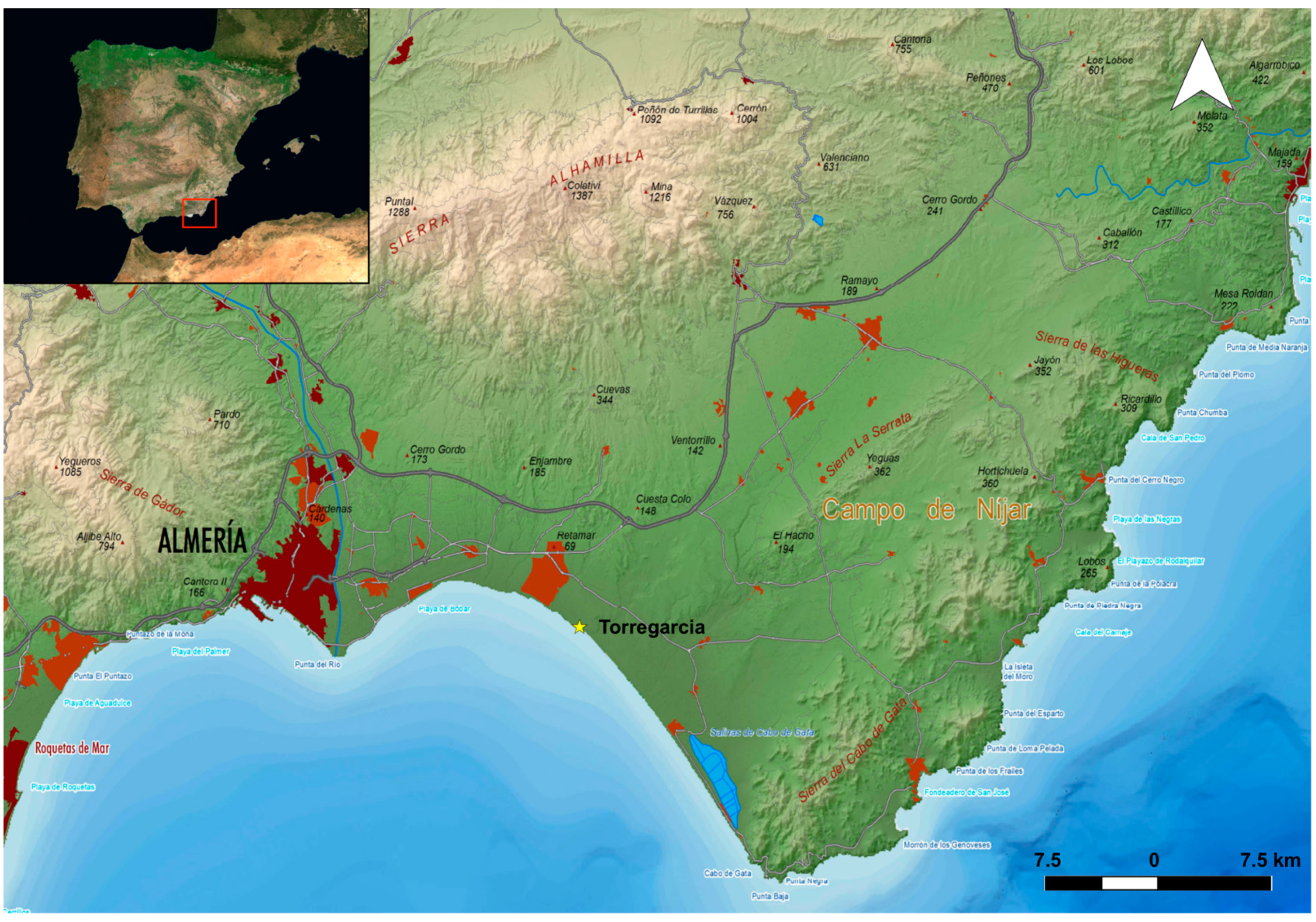
The archaeological site of Torregarcía (Almería, Spain) is located by the sea, on the beach of the same name, very close to the Amoladeras wadi (
Figure 1). It is situated within the western boundary of the Cabo de Gata-Níjar Maritime-Terrestrial Natural Park. Both its terrestrial and maritime areas provided an exceptional environment for the varied and abundant resources necessary for producing purple textile products and the livelihoods of its producers in Roman times. The archaeological materials found date its activity to the Imperial period (South Gaulish and African
terra sigillata and fish sauce amphorae—made in
Gades and North African oil amphorae), focusing mainly on the 1st–2nd centuries A.D.
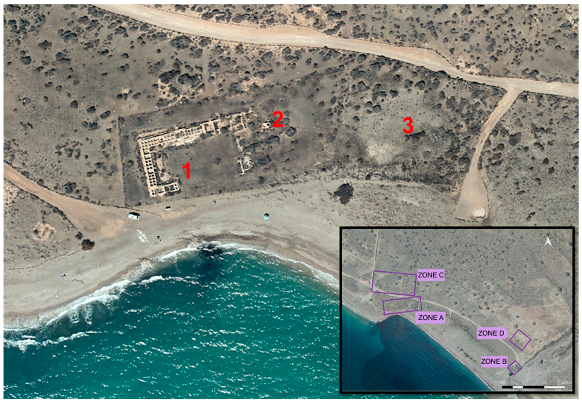
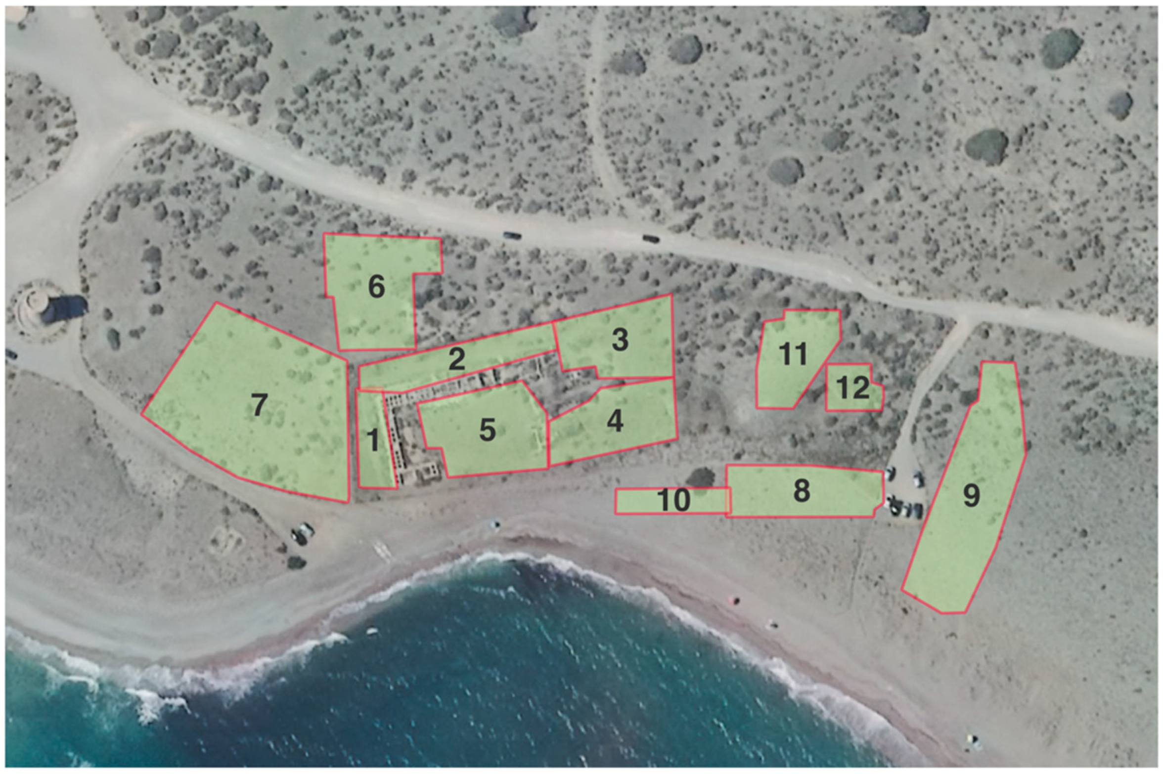
This site had already been known for decades for its visible structures. In 1984 it was included in the Pre-Catalogue of the Archaeological Heritage of the Province of Almería, although an archaeological excavation was only been carried out in 1990, directed by José Ramón Ramos Díaz, which revealed its importance. In this action, an archaeological area of 5600 m
2 was documented, and structures were located that were associated with a presumed Roman salting factory where the complementary dyeing activity was also practised (which we have called Zone A) (
Figure 2). Approximately 240 m
2 were excavated, and groups of basins of different sizes were documented and arranged around a large central courtyard; annexed to these were rooms linked to the storage and management of the productive activity (Area 1). Next to these structures, a water-supply area with a well was located (Area 2), and finally, an artificial elevation formed by remains of molluscs, Roman ceramics of different chronologies, and sandy deposits identified as a shell accumulation related to the extraction of purple (Area 3).
Preliminary analysis of this shell midden, carried out by Dr Diego Moreno Lampreave employing surface sampling, indicated that among the mollusc remains,
Hexaplex trunculus dominated with 93%, followed by
Euthria cornea with 3%, and
Bolinus brandaris with only 2%. Therefore, the dominant species was
Hexaplex trunculus, the mollusc that provides the best quality purple dye, which is frequently found in other Hispanic sites such as those of Sa Caleta, Cala Olivera and Canal d’en Martí in the Balearic Islands [
1] (pp. 256–261), Águilas (Murcia) [
2] (p. 217),
Carteia (San Roque, Cádiz), specifically in the Villa Victoria excavations [
3] (pp. 233–237), and also in North Africa, where, for example, in Euespérides (Libya) it reaches 95.47% [
4] (p. 168), or in Metrouna (Morocco), it ranged between 90.55% and 99.12% [
5] (pp. 183–184). In addition, we have documented tools typical of
murileguli-conchileguli work, such as stone hammers for striking punches, objects that have also been found at the nearby site of Paraje de Casa Fuerte del Toyo (Almería), as well as at sites such as Villa Victoria (
Carteia, Cádiz) [
3] (p. 215) or Lobos 1 (Fuerteventura, Canary Islands) [
6] (pp. 97–100). Also, near the Amoladeras wadi, an area of habitation was excavated on a slight elevation, which could be dated to the 2nd century A.D. due to the associated material (especially kitchen pottery and African
terra sigillata) (Zone B).
Even with these remains, these production facilities have gone almost unnoticed in the historiography of the last three decades as they have never been the subject of a scientific publication. However, they have been mentioned in several works dedicated to the southeast of the Iberian Peninsula [
7] (p. 309) [
8] (p. 70) [
9] (pp. 930–931) [
10,
11].
This case study was chosen for two reasons: it is an emblematic site in the Cabo de Gata-Níjar Maritime-Terrestrial Natural Park (Almería, Spain), and, on the other hand, the state of conservation of its Roman
purpurarii installations makes it a significant site for analysis using combined techniques under the classification of non-invasive methods. With this objective in mind, we carried out two campaigns: one in November 2019 and the other in April 2021 [
12]. This fieldwork led to the virtual documentation and georeferencing of the structures already excavated, as well as the location of others linked to this same site: Zone C, associated with construction, and Zone D, related to another shell midden. Progress has also been made in their characterisation as
officina purpuraria. The main objective of this paper was to present some of the results obtained through the use of these non-invasive documentation techniques, specifically those related to areas 1 and 2 of Zone A.2.
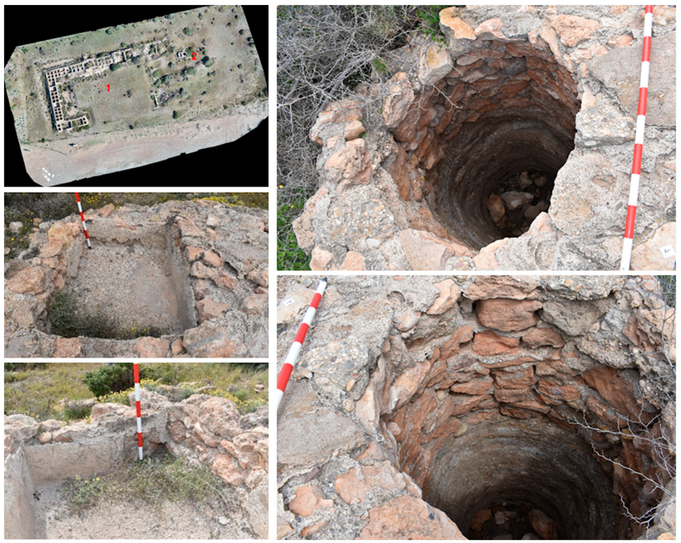
2. Main Building Complex (Zone A: Area 1)
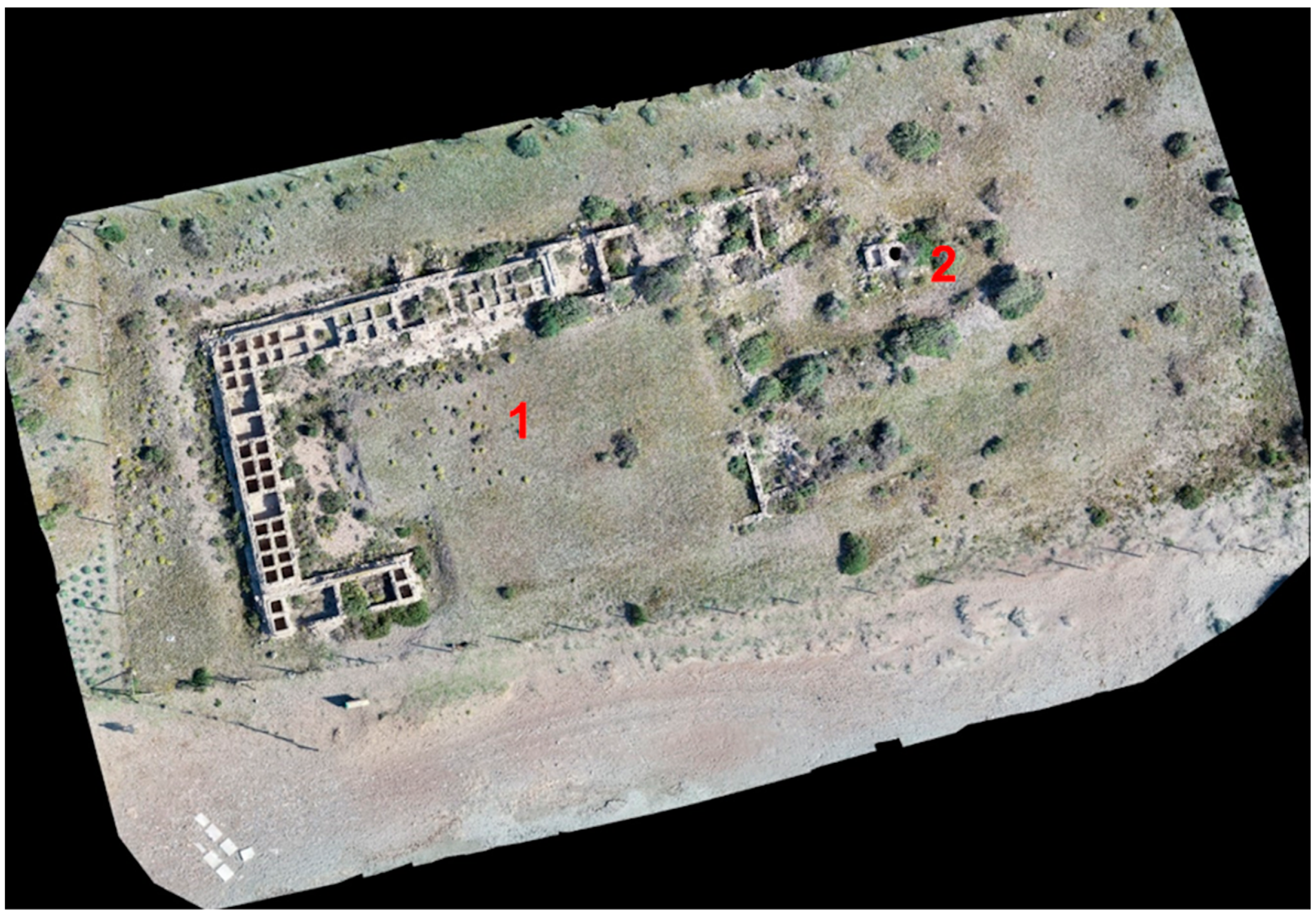
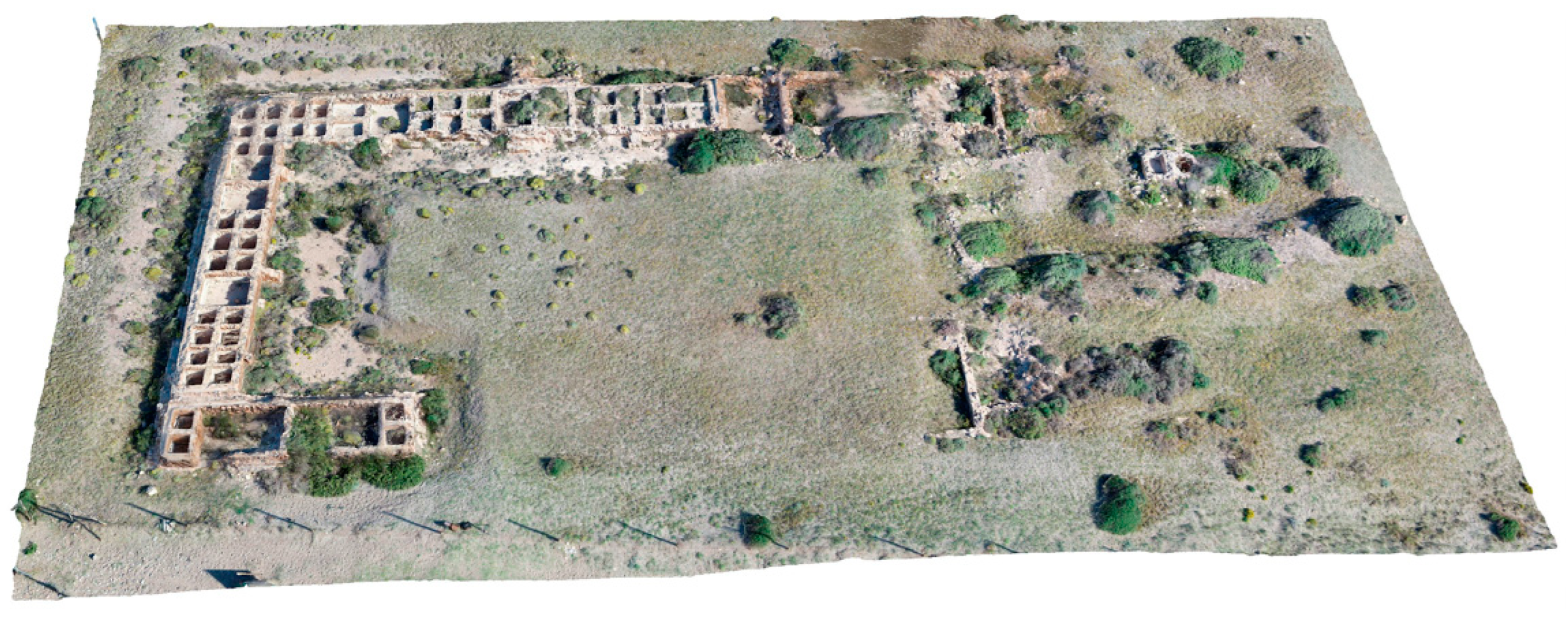
The main building was used for construction related to the processing of marine products and probably to purple extraction activities (
officina purpuraria) and textile dyeing (
officina infectoria) (
Figure 3). The maximum dimensions of this building are 49.43 m (NE-SW) and 24.34 m (NW-SE), which have been preserved. The building is made up of three naves articulated perpendicularly around a courtyard which is open to the sea on its south side. This building, therefore, appears as a single, organic whole, probably single-phase, as no modifications or additions to the building can be seen that would correspond to its phase of operation in antiquity. The courtyard measures 36.37 m × 16.81 m, giving a surface area of 611.38 m
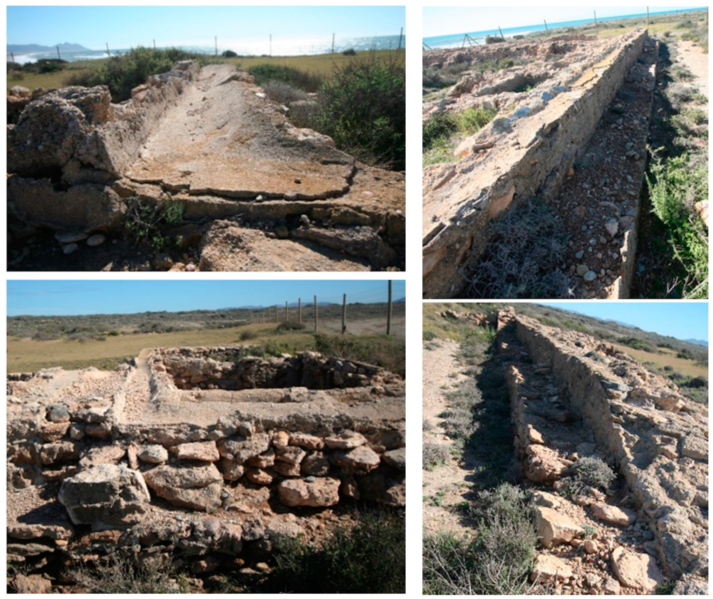
2. The size of this central courtyard is worth noting, which does not correspond to the standard dimensions of similar spaces in the smaller, more reduced spaces of well-known High-Imperial salted fish factories.
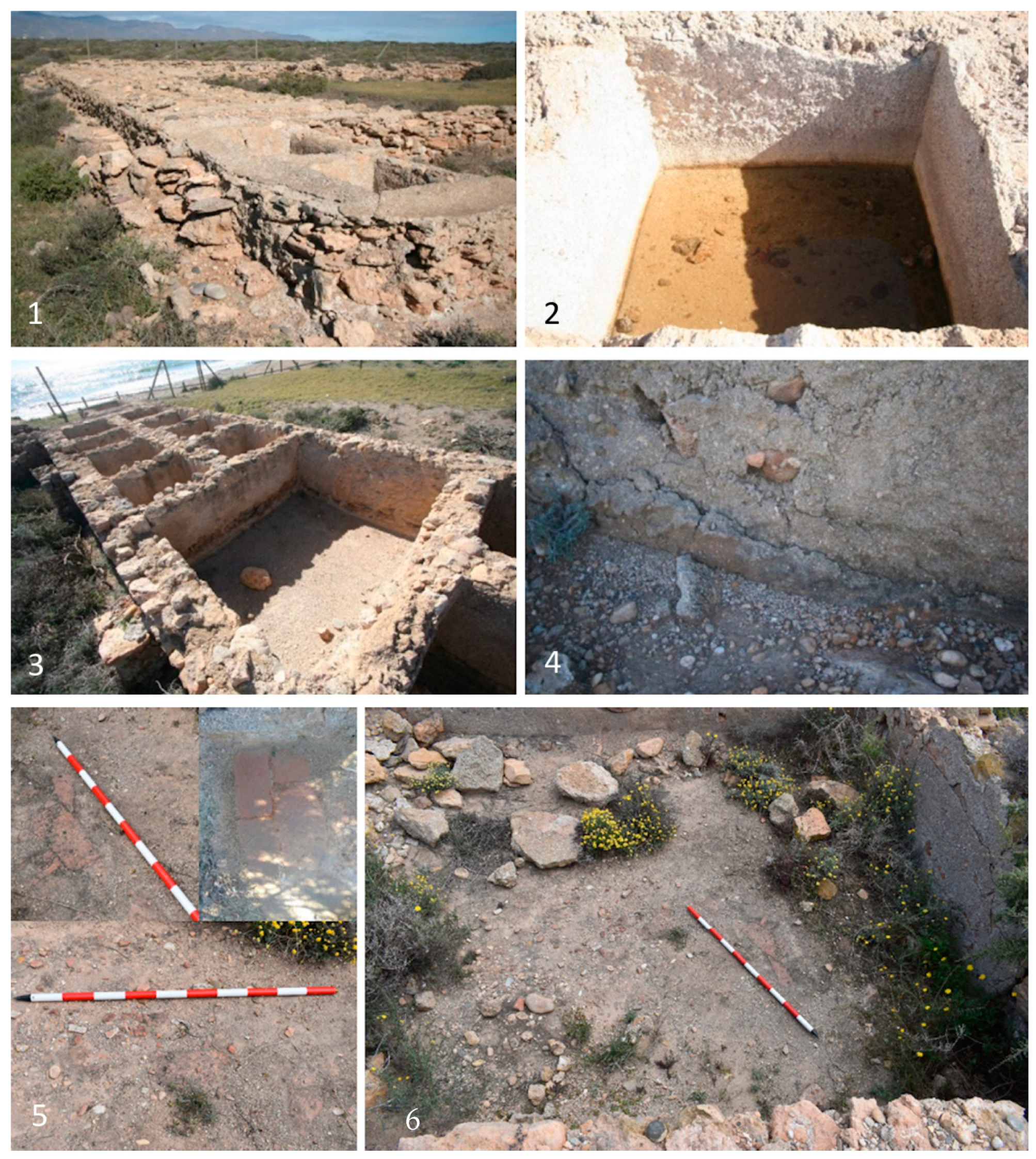
The first bay is located on the north side of the building. This part of the building has a total length of 49.43 m. At its northeast end, at least four rectangular spaces were located, three of which are well-defined and a fourth that is only partially defined. The first space has only its north and west sides visible, with interior dimensions of 4.36 × 3.70 m. Next are two rooms interconnected by the dividing wall, the first measuring 4.15 × 3.30 m and the second 7.20 × 3.30 m. The fourth space, open on the north side to the outside of the complex, measures 3.25 × 4 m. Several doubts remain regarding this set of spaces. For example, it is unclear whether the opening to the exterior or the interconnection between the rooms is the result of later work on the complex and is not part of the original design. The functionality of these spaces is also unclear, as in some cases, they still have a tiled floor, which would rule out their relationship with the production process in the complex and link them to other activities typical of the
officinae. (
Figure 4). This installation was necessary for the workshops dedicated to producing the
purpura dyeing of fabrics, as in the fish-salting factories. These are areas dedicated to the storage of products and tools, and packaging. Fernández Uriel also proposed that these were used for perfuming and preserving fabrics with aromatic plants such as lavender [
13]. Administrative functions should not be ruled out for these spaces either.
The described structures are followed by the large
lacus characterising these production facilities, which is 27 m long in this sector. All the basins in the complex are built on a masonry base with lime and sand mortar (
opus incertum), which is the same technique used in the elevation of the walls. The thickness of the walls is about 43 cm on average, approximately a foot and a half. On the inside, there is fine plastering consisting of hydraulic mortar coatings, although not all of these are preserved. These
lacus do not have the typical half-round base usually associated with salting basins, nor are there any cleaning pressures on the floor, unlike those found in
cetariae. However, they do have an upper channelling with curbs, whose function seems to be related to the interest in avoiding overflows of liquids, redirecting them to the interior of the basins and even facilitating a particular circulation of the liquid between the different sets of basins, all of which is compatible with activities typical of an
officina infectoria (
Figure 5).
Continuing with the description of the spaces within the building, a group formed by a series of
lacus can be observed, where small spaces alternate (around 1 m on each side, built on the module of three Roman feet [
14]), arranged in two parallel and symmetrical rows, and other larger space that are approximately 2.12 × 2.30 m. The depth of these spaces in unknown as they are currently clogged. However, it is estimated that te average depth is 0.80 cm.
The west aisle of the complex, 24 m long, offers a similar layout, with alternating sets of small and medium-sized
lacus. The third aisle, 12 m long, at right angles to the previous one, begins with two 3-cubic-foot
lacus and then two larger rooms, although these could also be identified as hydraulic structures. They measure 3.86 × 2.30 m and 4 × 2.30 m in size. The first shows access to the outside complex, although it is likely a later modification. Moreover, the complex is closed with two other
lacus of 1 cubic foot each. The entire complex was enclosed on the outside on the north, west, south, and east sides by a perimeter wall, whose height is unknown, with an average thickness of 0.65 cm. This wall is also present on the inside face of the third bay. It is interesting to highlight the presence of various buttresses or podiums arranged irregularly inside the courtyard. This actual structural disposition can be linked to the needs of the installation work and the handling of the product placed in the
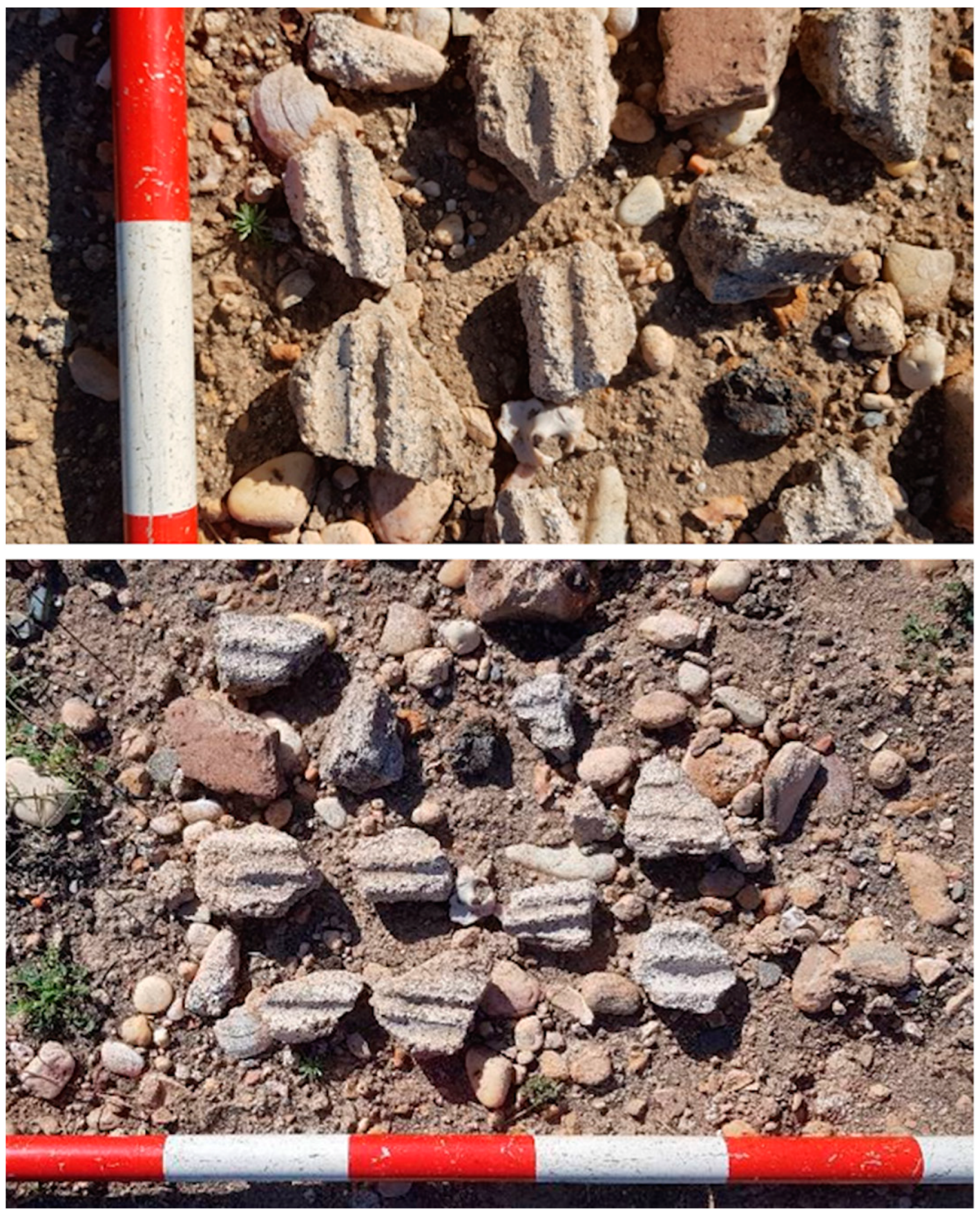
lacus. Alternatively, it could be related to roofing supports covering the working space; among the materials there are numerous mortar remains with reed imprints. These materials indicate that in Roman times the
lacus and the courtyard may have been covered by a light roof (
Figure 6).
The eastern area of the complex is the most poorly known, although it was partially excavated. The analysis of the orthophotography allowed us to identify several built spaces with an orthogonal layout, but archaeological interventions are necessary to elucidate their configuration. It does seem that part of the building is articulated and closes off the productive implant to the east, while other elements seem to have other functional spaces more oriented towards the outside of the
officina. Precisely, the latter is related to the area where an underground water collection system is located. There is a circular well with an external diameter of 2 m and an internal diameter of 1.10 m, which goes deep, breaking through the geological substratum made up of glaciers. To this well is attached a small
lacus measuring 0.90 × 1.30 on the inside, built with walls 0.35 cm thick (
Figure 7).
3. Methodology
The Torregarcía site has specific characteristics that condition and guide the type of method and the ideal instruments for its application in the study. Firstly, an essential part of the constructive structures emerging from the ancient installations is visible, either because some of their hydraulic elements have remained in use or because the coastal wind processes have periodically covered and uncovered the dune mantle characteristic of the area, or because the archaeological excavations carried out have exhumed part of the installations. As a result of these circumstances, a large part of the site is currently visible, and another part remains buried. In addition, it is to be assumed that, as a result of the occupation and the productive activity carried out in Torregarcía, the site also contains archaeological elements characterised as negative structures, some visible and others unknown.
The application of non-invasive techniques and methods in cases such as Torregarcía is aimed at obtaining helpful information for the documentation and research of the site. In other words, in this case, work was carried out with the primary objective of accurately documenting the current state of the archaeological building structures located in Area 1 of Zone A. On the other hand, techniques have been applied to obtain information on the buried and non-visible elements of the site in Areas 1 and 2 (Zone A), more oriented towards historical study and research and to obtain a complete vision of the productive complex and its function as a purpurarii installation.
3.1. Photogrammetry and Laser Scanning
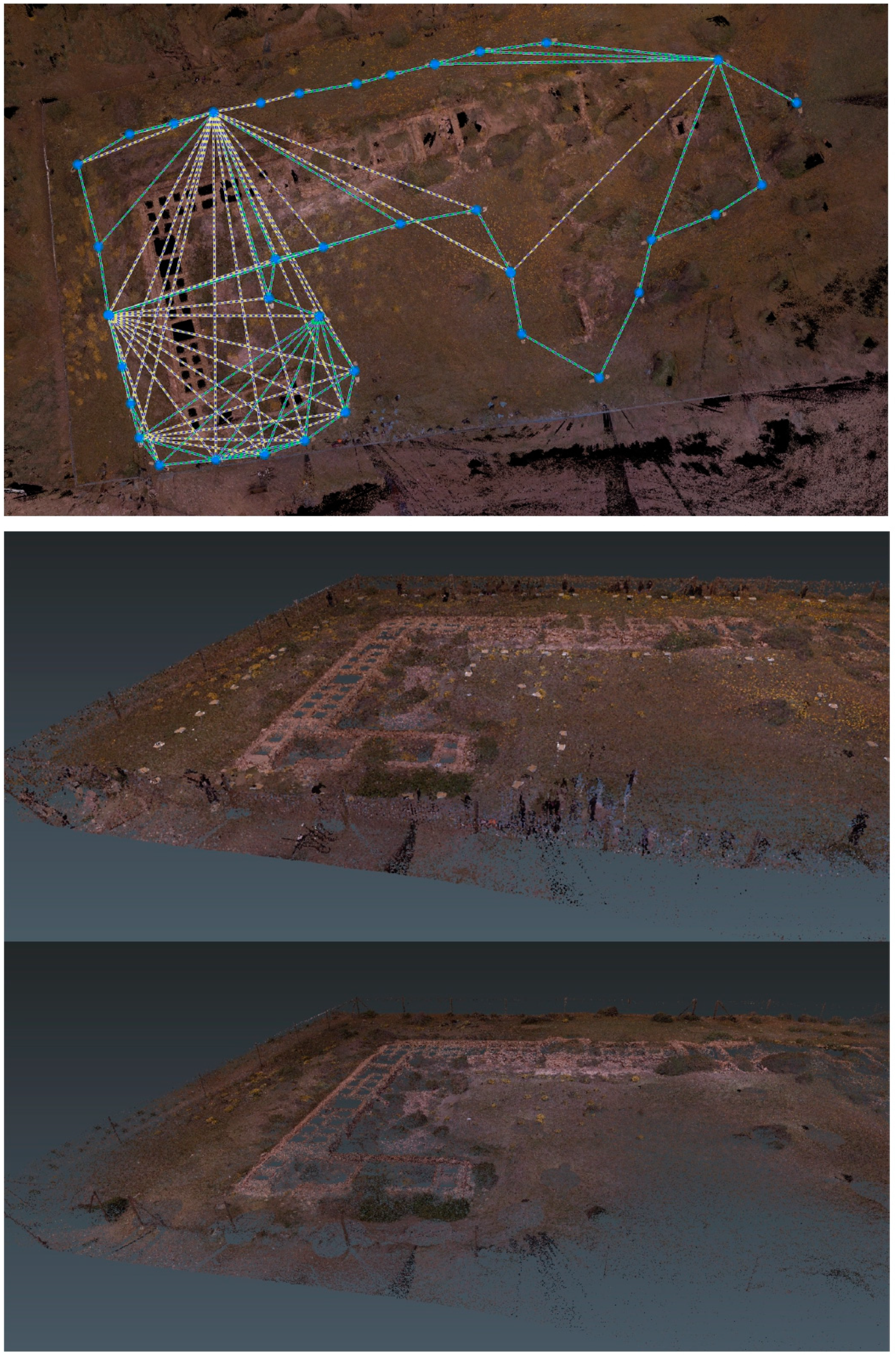
The work to document the site’s current state included the three-dimensional recording of the architectonic structures of the officina purpuraria used for productive processing (Zone A: Area 1). For this purpose, photogrammetric work was performed using various instruments in a combined manner. On the one hand, cross-mesh flights using a UAV Phantom 4 Pro+ were used; on the other hand, traditional photogrammetry was carried out with a Canon EOS 6D camera. Finally, the entire site was scanned with a Leica BLK 360 terrestrial laser model. To obtain the geopositioning of the photogrammetry and laser scanning works, these were georeferenced with the GPS-GNSS model, and with a total station model Flexline TS06 Plus, both from Leica. We had the collaboration of Manuel Ruiz Barroso. As for the laser scanning, the work began with the placement of the control points necessary for the subsequent georeferencing process of the three-dimensional model. Four Black and White targets were used, specially designed by Leica for maximum compatibility with the Cyclone Register 360 post-processing software. In order to cover all the structures along the outer perimeter, 42 scans were made, the parameters of which were: high scanning density—to obtain a model with the highest possible accuracy; taking photographs, and with the camera’s HDR mode activated.
Once the raw data had been obtained using the Leica Cyclone Register 360 software in the laboratory, they were transformed into point clouds with real colours that could be exported to different formats. The 42 scans taken were aligned and georeferenced, introducing the coordinates of each Black and White target used during the digital survey and identifying each within the software. The first point cloud was obtained (900,281,512 points in total), with an accuracy of 0.013 m, an overlapping 52% and a strength of 66%. Subsequently, the point cloud was classified and debugged using Cyclone 3DR (version 2022) (
Figure 8).
Concerning aerial photogrammetry, a double grid mission was programmed, in which the UAV took photographs along several parallel and perpendicular streets at an altitude of 15 m from the take-off point. This process achieved a theoretical GSD of 0.44 cm/px. The Phantom 4 Pro+ took photographs along seven lanes in a northeast-southwest direction and 14 in a northwest-east-southeast direction. The camera’s angle was chosen at 70°, ensuring a sharper shot of the structures and obtaining more information from those surfaces of the structures in a vertical plane. The overlap was 80%, so the three-dimensional model’s accuracy and reliability would be as high as possible. Four targets were used for georeferencing, located at each of the four corners that form the rectangle of the UAV flight grid. This way, 320 photographs were taken from different angles, allowing the post-processing software to generate a much more complete point cloud.
Regarding the terrestrial photogrammetry, the route followed was the same as the one used during the digital survey work with the BLK360, scanning along the entire outer perimeter of the structures. A total of 590 photos were taken with the lens at a focal length of 50 mm, the optimum distance for photogrammetric surveys. The georeferencing model used 18 targets in the structures’ vertical and horizontal planes. Black and white targets smaller than previously used were placed on the structures so they did not suffer any damage.
Finally, all the photographic material was arranged to identify targets and insert coordinates so that all the products were adequately georeferenced. The following steps established the alignment of the images and searched for spatial points that coincide due to the overlap between photographs. This process generated a total of 640,797,741 points cloud, enabling the software to generate an accurate mesh and add a solid textured model (
Figure 9).
The data obtained through these different techniques and instruments were combined to obtain high-precision three-dimensional models, as we have done on other occasions on other heritage assets [
15,
16]. These models are beneficial for the building analysis of the Torregarcía factory, for obtaining all kinds of graphic and technical products that support its volumetric documentation, and its constructive and functional analysis.
3.2. Magnetometry
Other techniques and instruments applied to the archaeological site were used to increase the knowledge of its still invisible parts, interventions carried out more for research purposes than for documentary recording (Zone A: Areas 1 and 2). One of the geophysical techniques applied was magnetometry, aimed at detecting archaeological structures of different types, characterising the magnetism of the subsoil, and obtaining data that provide potential functional interpretations of the archaeological spaces.
For the magnetometry work, equipment suitable for the characteristics and geographical conditions of the exploration areas was used in Torregarcía. The site, which is partially excavated, has abundant emergent structures, the archaeological cuts of its intervention are still preserved, and it is also fenced and enclosed for its protection. In addition, due to its location on the grounds of the natural park, it has endemic and protected vegetation. For this purpose, a Sensys MX V3 magnetometer was used. The MX V3 is a modular multichannel magnetometer with FGM650/3 fluxgate gradiometers mounted in an array on a manual or motorised trolley. The Torregarcía studies used a manual configuration of five gradiometers with a 0.25 cm separation between them. In order to obtain precise, georeferenced information to support the work of the magnetometer, Stonex S10 and S10A GPSs were used in the base-rover assembly. Javier Catalán González and José Antonio Ruiz Gil collaborated on this survey.
The methodological process used in the field was as follows: preliminary analysis of the surveyed areas; creation of GIS projects for data management; photographic documentation of the areas explored; magnetic exploration with Sensys MX V3 manually pushed equipment in its five gradiometers configuration; and data capture process using Mon MX software, storage in the MX Compact V3 Central Unit. Post-processing of the scan data was carried out in the laboratory using DLMGPS and Magneto software.
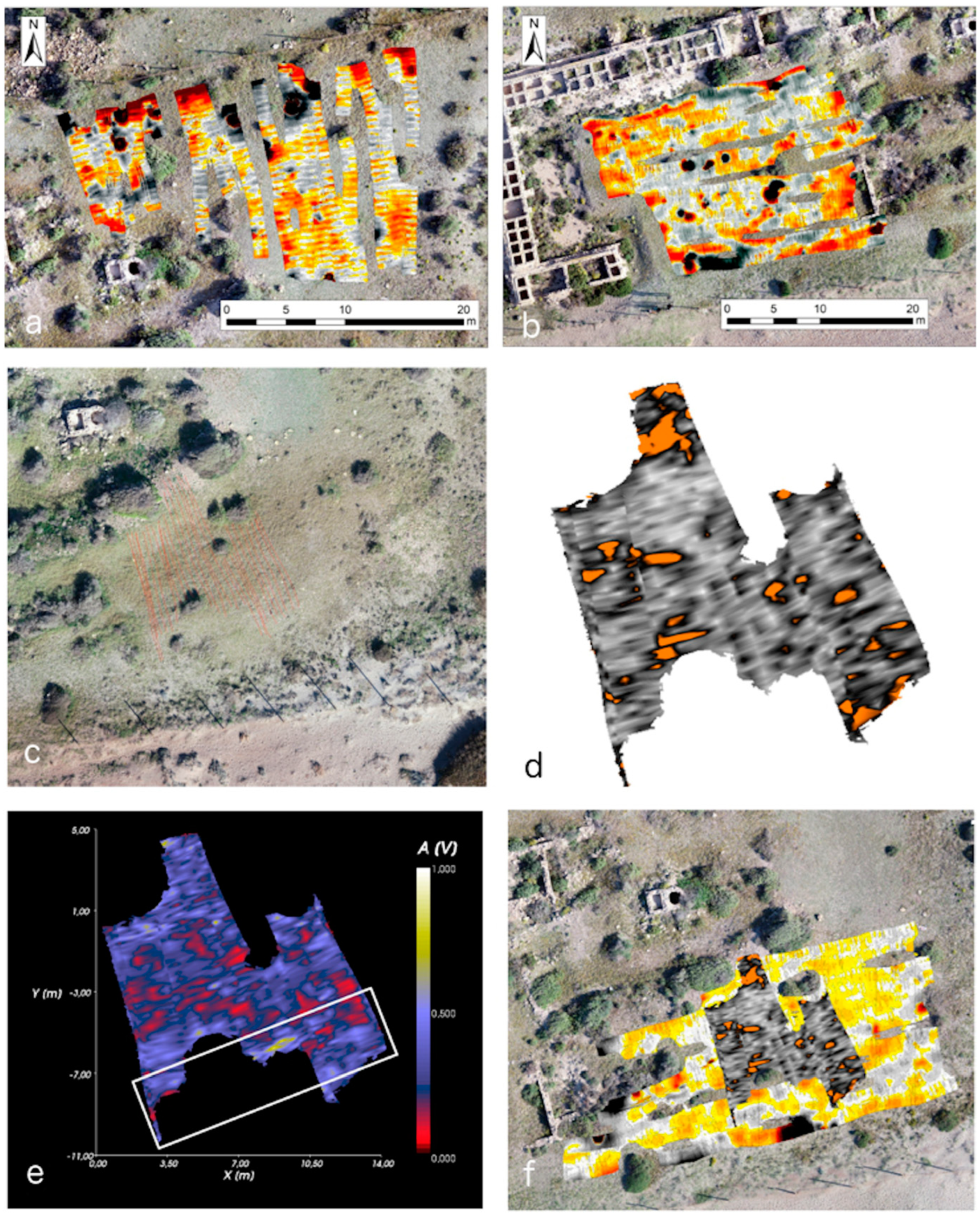
Twelve plots were worked on, with 12 individualised magnetometry survey projects in Zone A of Torregarcía (
Figure 10). These projects have different orientations and dimensions, as they were elaborated according to the characteristics and elements offered by the terrain. For the present paper, we selected the so-called Project 03 (in Area 2), 04 (bordered to the north by Project 03 and to the south by the fence in Area 2) and 05 (inside the central courtyard of the building complex, Area 1), which coincide in surface area with the exploration carried out by the GPR.
3.3. Ground Penetrating Radar
The other geophysical technique used was the GPR aimed at detecting archaeological structures of different types. Due to the same site conditions mentioned above, a hand-held traction GPR, model RIS Hi-mod A1 of the IDS company, single-channel and two-frequency (200–600 MHz), was used. This GPR comprises two antennas that simultaneously emit electromagnetic pulses at two central frequencies, 200 and 600 MHz. This configuration’s maximum data acquisition rate is 9 km/h, with 512 samples per scan (@512 Sample/Scan), with a scan interval of 42 scans/m and horizontal antenna polarisation (H.H.). The data capture software used was ONE VISION, and the GPR processing software GRED HD was developed by IDS. A Leica GS14 GPS-GNSS model GS14 was used for geo-position.
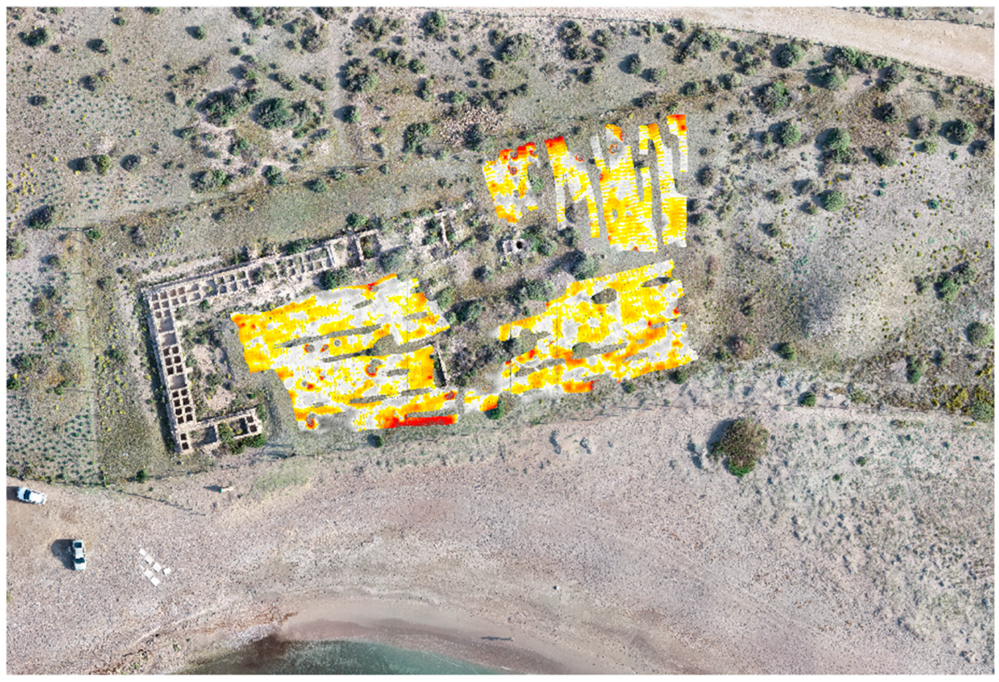
This equipment was used to explore the open spaces inside the site’s enclosure in three areas within the archaeological complex defined by the structures currently visible: the inner courtyard of the productive building complex; the southeast sector of the archaeological enclosure; and, within the same, the east sector, which has given rise to three projects. Project 1 was undertaken inside the main building complex of the site, in the inner courtyard (Zone A: Area 1); Project 2 was developed at the S.E. of the main building complex (Zone A: Area 2); and Project 3 was carried out to the N.E. of the main building complex (Zone A: Area 2). Different visualisations of the data obtained after processing the information were used to analyse the results obtained in each of the three projects carried out in the areas of interest. On the one hand, we will use a planned view of the projects at the height of 1.5 m to show the details of the most potent anomalies detected at this depth. On the other hand, we will offer plans for each project at the 1.5 and 0.5-m elevations, with a visualisation adjusted to a 1000 V amplitude. The former allows us to differentiate between high and low-intensity elements, while the latter preferentially represents low-intensity anomalies, some of which could be related to negative archaeological structures.
The comparative analysis of the results of both equipment in the same spaces, magnetometer and GPR, was necessary and has been carried out in other archaeological contexts [
17,
18,
19,
20]. Comparative results are shown for the same environments from magnetometer scans. In this case, a +24/−27 nT cut-off display was used.
Finally, a unique experiment was also carried out on the large shell midden containing remains of the productive activity of the
purpuraria, combining magnetometry and GPR. In this sense, the work carried out by Isabel Rondán Sevilla was decisive [
21].
4. Results
4.1. Main Building Complex (Zone A: Area 1)
4.1.1. Photogrammetry and Laser Scanning
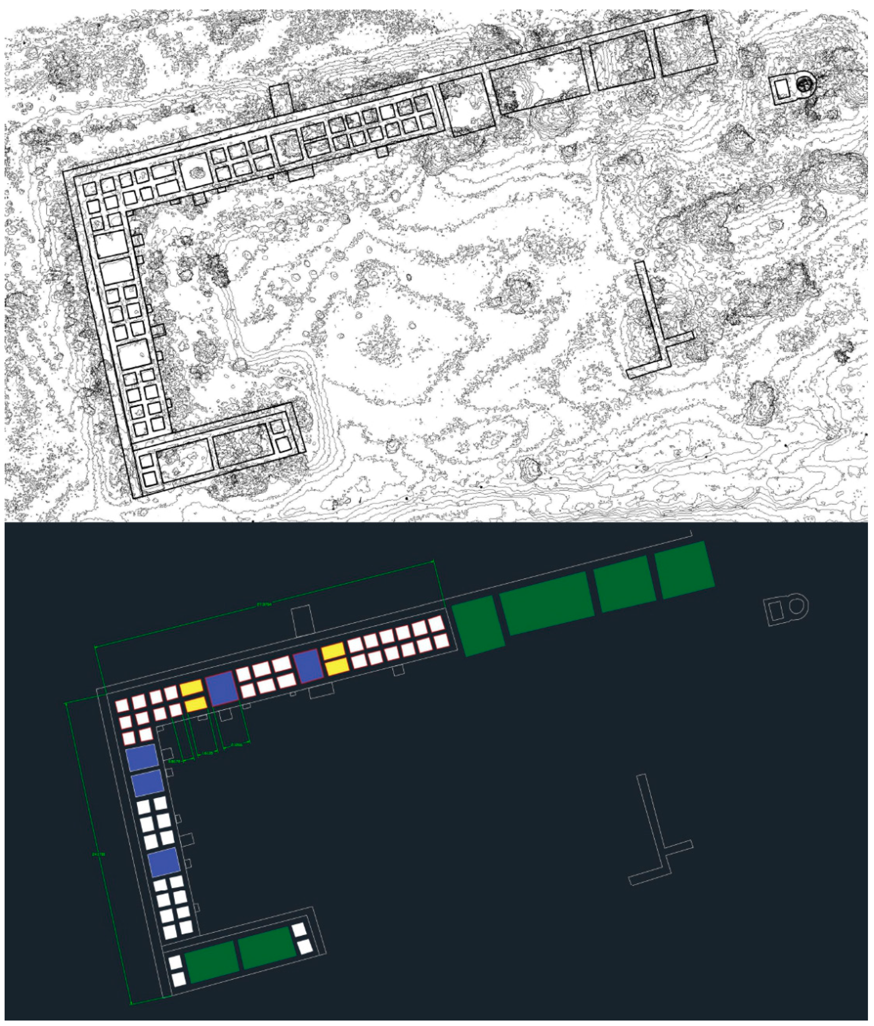
The application of different three-dimensional digital survey techniques at the Torregarcía site enabled us to obtain a complete, high-resolution model of the site. The shortcomings of the point cloud obtained by terrestrial LiDAR were covered thanks to the aerial photogrammetric cloud and vice versa. Following this technique, it was possible to confirm two main aspects: the limitations of each technique and the strengths when applied to a site of these characteristics. The point cloud resulting from both digitising techniques can be subjected to considerable processing. One example is the possibility of extracting any orthogonal plane (
Figure 11) whose parameters can be examined. Furthermore, as it is being observed with a fully georeferenced and very accurately dimensioned cloud, all kinds of two-dimensional and three-dimensional measurements and calculations can be carried out, which provide us with a more significant amount of information about the productive capacity that the facilities under study may have had at the time.
One example is the dimensions of the
lacus. We are going to describe those of the first nave in the E-W direction: first, we find a group of 12
lacus arranged in two parallel and symmetrical rows, all measuring around 1 m on each side; to the west of this group are two
lacus of similar dimensions, measuring 1.75 × 2.30 m; then another group of smaller basins, six in number, arranged in two parallel and symmetrical rows, the first four are slightly larger—around 1.30 × 1 m—while the last two measure 1 × 1 m; Continuing to the west is a quadrangular
lacus measuring 2.12 × 2.30 m, followed by two rectangular
lacus measuring approximately 1.70 × 1 m; the western end of this aisle contains eight small
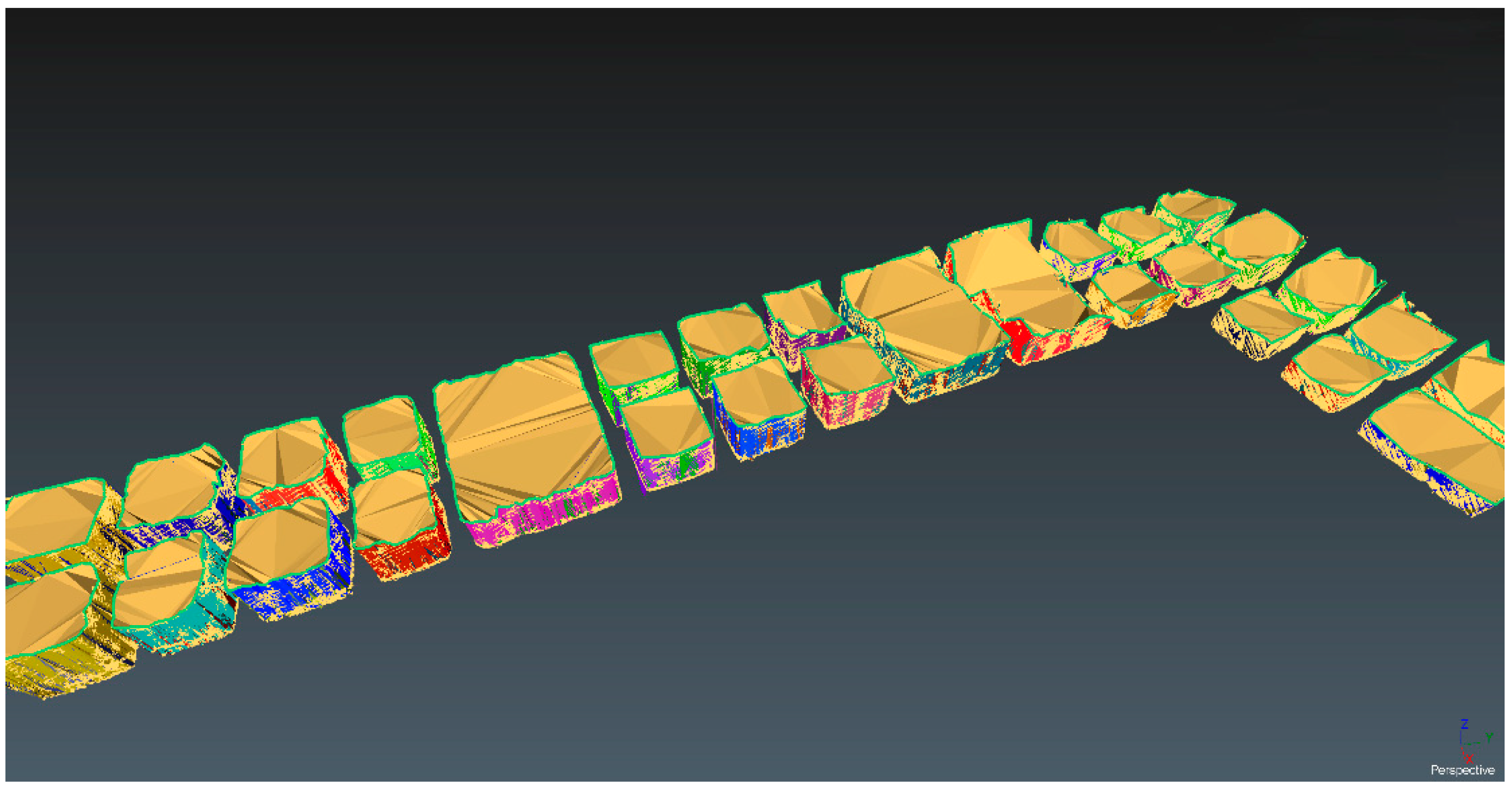
lacus, in parallel and symmetrical rows, with an average size of 3 × 3 × 3 Roman feet each. Finally, it was possible to calculate the volumes of all the basins that did not show clogging (
Figure 12). The extraction of these volumes was possible in a total of 34 basins, and from this, we were able to know that the total capacity of these basins is 29.38 m
3.
As has been indicated, the installation has channelling arranged at the upper height of the basins. It is preserved in good condition in the north nave, between the outer face of the sets of lacus and the perimeter wall, and also at the east end of this nave, limiting the first set of small lacus, and connecting perpendicularly with the previous channelling. It is also present around the perimeter of the basins in the south aisle. This type of element must have fulfilled a specific function in the operation of the installations and its detailed analysis, through the precision digital model, constitutes an element of interest to advance in the study of the working processes in the officinae tinctoriae.
4.1.2. Magnetometry and GPR Application
The Central Courtyard
Non-invasive surveys were carried out in the central courtyard using a multichannel magnetometer and single channel double frequency GPR, detecting interesting elements in and around the courtyard. For the magnetometry, Project 05 was carried out inside the building complex (
Figure 13). It covers an area of 387 m
2. The magnetic values were between +432/−347 nT. The central values were related to a dipolar anomaly located almost in the centre of the project and identified as a metallic element in the GPR scan. Other minor dipolar anomalies are scattered over the surface of the project. The southern end shows values influenced by the metallic enclosure of the array. Most of the readings were between +10/−10 nT, which offer a representation of the geological stratum, but also of anthropic elements, as several areas delimit the representations of the magnetic values with elements with N-S and E-W orientations similar to those of the
officina purpuraria. Consequently, several of these geometries can be seen in the N.W. corner of the exploration and along the entire eastern side.
With the GPR results, Project 1 was developed. It was executed with an S-N orientation and is composed of passes spaced approximately 20 cm apart; it has an E-W width of 21.5 m and an S-N length of 22 m; it covers an area of 406 m
2 (
Figure 14) and corresponds superficially with Project 05 of the magnetometry works. For this project, the visualisation at −1.5 m shows a series of linear anomalies, with thicknesses between −0.5 and 1 m, which develop in an SW-NE direction. These anomalies begin to be seen at around −0.80 and develop in-depth up to approximately −2 m. We interpret these anomalies as elements of the geological substratum on which the Torregarcía site is located, glacis or fossilised beach formations. The alignments of anomalies are compatible with the outcrops detected in the intertidal space in front of the
officina. Alignments are also documented south of the archaeological construction remains, outside the installations and next to the current coastline. The geology also crosses the existing well in the complex to access the water table (
infra).
At higher elevations, around −0.5 m, there are also no anthropogenic building elements. However, at these heights, we should consider the elements that show less amplitude and potentially relate to archaeological remains of little power or negative structures. This approach makes it possible to identify some linear anomalies arranged in an N-S and W-E direction located in the N.W. corner of the survey. These anomalies could be interpreted as light structures, or possible ditches or channelling, typical of this kind of industrial complex running through that part of the courtyard of the
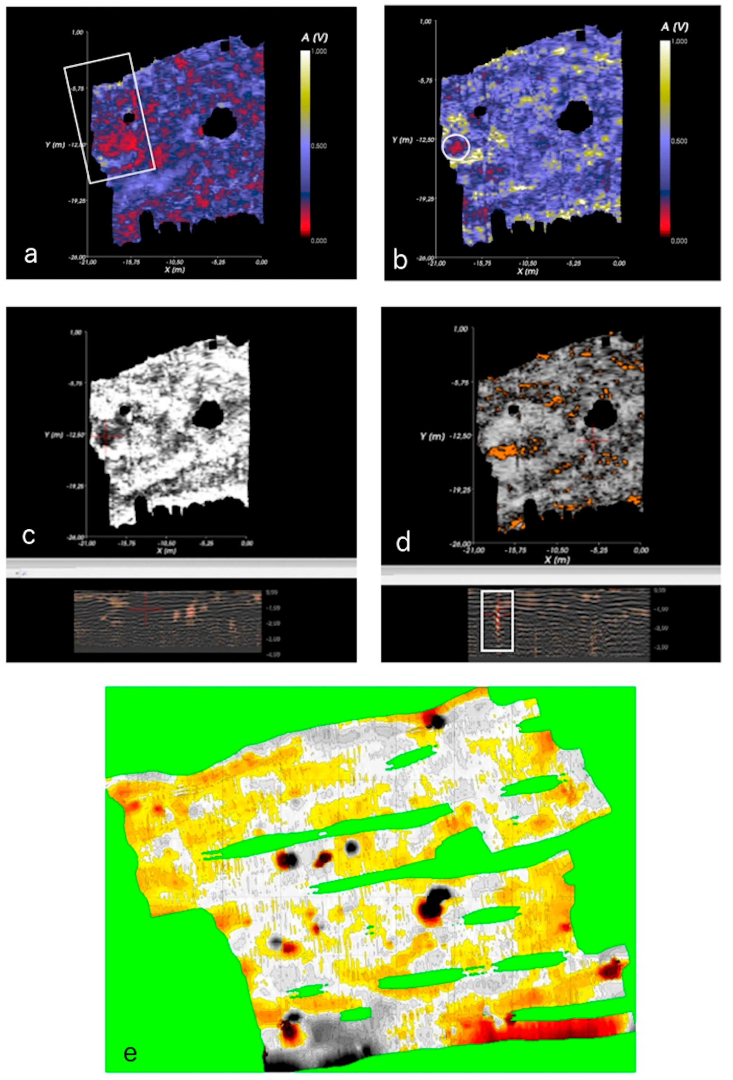
officina. It is possible to identify anomalies of this nature in the S.W. corner of the survey, where traces of the south wall of the enclosure of the installations seem to be detected. In addition, there are areas with flat deposits in profile, located at around −0.40 m, which may be related to potential pavements located in areas of the courtyard, but may also correspond to natural deposits generated between the geological formations of the substratum described above (
Figure 15a). Two other elements can be highlighted from the reading of the Project 1 radargram. The first is a structure that could be interpreted as a pit. This structure could be similar to the one seen on the surface (
Figure 15b,c). A metallic element, in an archaeological context, was also detected by the magnetometer scan (
Figure 15d).
This area’s magnetometry offers a reading of the geological substratum and the natural or artificial elements established between these linear formations. Few strong magnetic anomalies were detected. Some of the magnetic anomalies discovered also overlap with the metallic elements identified with the GPR (
Figure 15e). The results helped us to exclude the possibility that the courtyard of the officina was the site of combustion necessary for the production of purple. However, this function, thanks to the anomalies shown by the magnetometry, could be related to other sectors, such as the one located to the west of Area 1 (Project 01) and the one located between the north exterior side of the archaeological structure and the protective fence (Project 02).
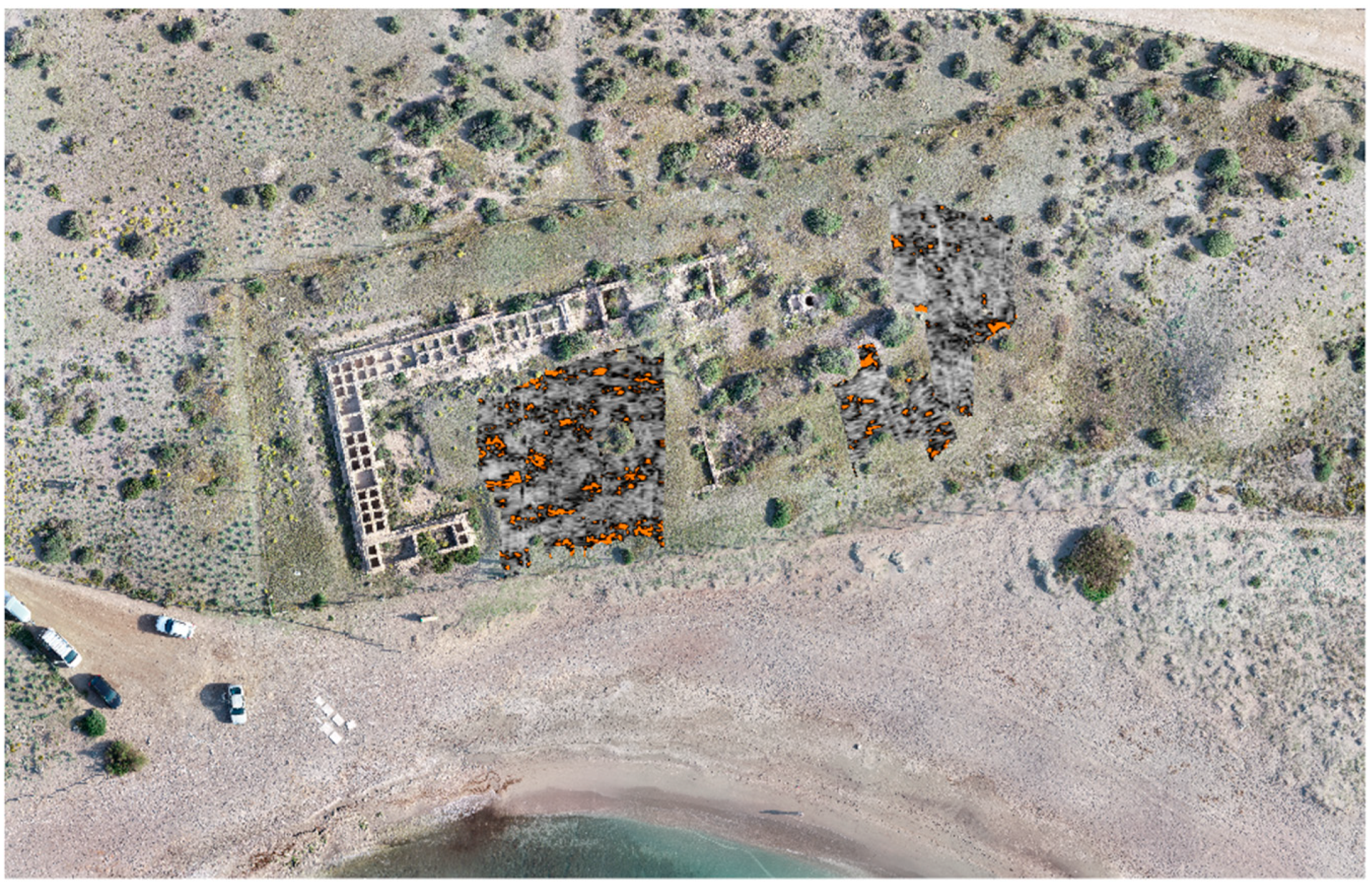
The Context of the Hydraulic Structures (Zone A: Area 2)
Complementarily, non-invasive surveys were also carried out using the magnetometer to obtain insights into the hydraulic structures in this sector. In terms of magnetometry, Projects 03 and 04 were carried out. The first of these is marked at its S.W. end by the well, and its N limit is the protective fence of the site (
Figure 16a). It covers an area of 262 m
2. Magnetic values are between +253/−274 nT. On the ground plan, positive anomalies can be observed, with values between +200/+225 nT, some of which have been contrasted with the GPR scan and allow us to identify them as metallic elements located in archaeological levels. As in the previously analysed project (Project 05), most of the readings are between +10/−10 nT and, in general, their conformation is aligned with the geological configuration, although some representations show a slightly different orientation, oriented towards the NE-SW. Furthermore, the S.E. corner of the explored area shows uniformity, which, due to its conformation, could be related to the existence of a paved space rather than to the geological substratum itself.
Project 04 is limited to the N by project 03 and the S by the fence (
Figure 16b). It was carried out with passes in an E-W direction. It covers an area of 321 m
2. The magnetic values of the scan are between +469/−200 nT. These extreme values are related to a dipolar anomaly close to the fence so that an archaeological interpretation can be ruled out. In general, the project shows low magnetism values, between +10/−10 nT. Unlike previous projects, these values, although they include the representation of the geological substratum, also show signs of anthropic elements. Specifically, in the central area of the project, the representation of the readings shows clear limits with N-S orientations quite close to the alignment in this sense of the emerging building structures. Thus, we would identify built spaces or pavements delimited by these, showing an area of about 8.5 m on each side. Given that the exploration was carried out transversally to these anomalies, it is impossible to interpret them as interpolations or edge effects of the data collection. Furthermore, looking at the southern part of the project, some anomalies may be aligned with the southern closure of the excavated construction complex.
Regarding the GPR results, Project 2 was developed to the S.E. of the main building, with an S-N orientation, and is made up of tracks with a space of 20 cm; it has an E-W width of 11 m and an average length of 11 m S-N (
Figure 16c); it covers an area of 100 m
2 and corresponds superficially with part of Project 04 of the magnetometry works. Results at −1.5 m elevation showed anomalies that can be connected to those documented in Project 1. For this reason, they are interpreted as extensions of the geological formations identified at the same depth (
Figure 16d). Examining higher elevations, some linear anomalies seem to correlate with the southern enclosure wall of the complex located to the east (at least coinciding with its direction and orientation). These results could indicate an extension of the enclosure in this settlement area, corresponding to Area 2 of Zone A of the site (
Figure 16e). Part of this project is developed over the area explored with the magnetometer in Project 04, which does not detect relevant anomalies on the surface coinciding with the GPR survey, except for the possible documentation, as in the case of Project 1, of the geological formations (
Figure 16f).
As for Project 3, this was carried out to the N.E. of the main building complex and was developed with an S-N orientation and is also composed of passes spaced 20 cm apart; it has an E-W width of 13 m and a maximum S-N length of 25 m (
Figure 17a); it covers an area of 220 m
2 and corresponds superficially with Project 03 of the magnetometry works. It connects with Project 2 to the south, showing continuity in the anomalies between the two projects. The information provided for this area coincides with the reviewed projects. The anomalies correspond to the geological substratum, characterised by their irregularity, depth, and organisation. These results are compatible with what was identified in Projects 1 and 2 (
Figure 17b). It is likely that the observed anomalies will be interpreted as a dumping area. The elevation of −1.70 forms a semi-circular layout which is not typical of the geological area and also located in the vicinity of the
officina shell midden (
Figure 17c). No elements can be identified that can be related to the buildings present in the complex. There are also some metallic elements in a stratigraphic context that are not superficial. At shallower levels, around −0.50, and enhancing the visualisation of small elements, areas of horizontal deposition were identified, compatible with natural fills and compacted areas that could be related to the activity of the production facilities (
Figure 17d).
The magnetometry in this area shows a succession of bipolar anomalies of high magnetism, arranged in a W-E direction, which could be related to areas of combustion, although also with metallic elements in stratigraphic contexts. However, the GPR exploration did not reach that area, and we cannot contrast the information provided by the equipment for these anomalies (
Figure 17e,f).
5. Discussion
An essential part of our research has resorted to the application of new techniques of non-invasive historical-archaeological documentation and study, and from the results, we can deduce relevant conclusions. Although all the techniques employed are documentary, some are advanced resources for creating virtual, three-dimensional, high-precision documentation of historical elements. The use of terrestrial scanning or LiDAR, together with aerial scanning applied to a semi-micro scale, has allowed us to obtain a complete and highly accurate three-dimensional model of the archaeological remains of Torregarcía. This model is a relevant product for tackling and applying all kinds of building, constructive and architectural analyses in the laboratory and the analysis of the production processes for which the facilities were intended. We have also tested modelling methods that have been little explored and demonstrated the suitability of the combination of terrestrial LiDAR and photogrammetry, both aerial and terrestrial, as complementary, as each these digital survey techniques makes up for the shortcomings of the other.
From the digital models generated, we can extract a large number of products and information of high historical-archaeological value, such as the building sections of the structures, orthoimages from different perspectives, but also volume calculations, exact measurements, planimetry, beneficial resources for the investigation of the site as a specialised productive space. The digital model of Torregarcía is also a reliable basis for the heritage management of the site, for its intervention and conservation, and, if necessary, for proposing anastylosis and more or less virtual reconstructions of the structures.
The combined application of geophysical techniques on the site has been very relevant, and the historical and experimental conclusions have been valuable, making Torregarcía a case study and methodological innovation. The GPR and magnetometry techniques have provided important information on the geological substratum where the enclave is located, thus contributing information that can be integrated into territorial modelling in the study of the landscape and the coastline on a macro scale. It also provides information on the original topography of the settlement and can contribute to the explanation of the architectural complex and its construction. For its part, magnetometry has made it possible to characterise the magnetic response of this space, to propose the existence of anomalies of untouched nature and, in addition, probably others of an anthropic nature, which enrich our knowledge of the complex.
The GPR was applied more selectively on the open spaces inside and near the archaeological preserved area. Surveys coincide with the areas designed for magnetometry and constitute a case study of combined techniques. The GPR has made it possible to characterise the stratigraphic layout of the site and has provided considerable information on the geological base and substratum and its behavior to natural depositional processes. It also suggests the presence of anthropic elements that broaden the overall knowledge of the site. As in the case of the magnetometer, it will support future interventions, and the reading of the geophysical anomalies detected will be fed back to the results of future projects. Among the contributions to the detection of new constructive structures, some are related to water management, but it has also allowed progress to be made in the chronostratigraphic knowledge of the settlement.
These works have contributed, although the data are not exhausted, to a better archaeological characterisation of the ars purpuraria on the Almeria coast, where the exploitation of the mollusc Hexaplex trunculus, which provides a high-quality dye, is dominant, as can be seen in the analysis of the malacofauna, mentioned in the Introduction.
6. Conclusions
According to magnetometry Projects 03-05, constructive elements associated with the settlement’s ancient phases can be detected in the areas located in the archaeological complex’s interior. It is relevant to highlight the difficulties in discriminating geological substrates from human construction due to the similarity of the orientations between the natural substrate and the Roman building and the possible similarity in the magnetic response of the construction material and the natural rock. We highlighted potential archaeological elements articulated in projects 04 and 05. Furthermore, we considered the characterisation of the geological substrate, which was already clearly detected by the GPR survey, as a contribution of magnetic exploration, as it allowed us to know in some detail the natural base on which the ancient settlement was developed.
Regarding the application of GPR, the analysis of the exploration allowed us to know the layout of the geological substratum and the underlying topography under the settlement, as well as the stratigraphic behavior of the archaeological area surveyed, information of great use for the planning of future archaeological interventions.
On the other hand, potential archaeological constructive elements were identified to complete the information currently available. Thus, the possible existence of enclosure walls and extension of the archaeological area, the detection of pavements in use, or the presence of possible hydraulic structures for water collection have been indicated. Some metallic elements have also been detected in stratigraphic contexts.
On the other hand, there seems to be no evidence of constructive phases prior to the known building, which contributes to the establishment of the foundational phase and the useful life of the settlement and its productive activity within the framework of Antiquity, at least in this sector of the site, since it cannot be ruled out that other previous phases of occupation were located in other nearby and/or amortised spaces.
What is fascinating is that the study of the inner courtyard complex does not seem to offer any archaeological elements that would compartmentalise it. This information helps us to understand the functionality and functioning of this crucial working space in the context of the officina infectoria and purpurarii. In addition to the possible well, potential paving areas can be detected, and perhaps ditches or channelling.
Comparing these GPR scan results with the magnetometry results is also of interest, both to complete this analysis and to feed back into the interpretation of the magnetometry results.
Finally, it should be noted that the digital model obtained at the site shows that the production complex was arranged to establish a circulation of flows from the N.E. to the S.W. end, something that can be seen both in the section of the lacunae and in the slope of the channelling arranged on the side of the lacunae. In the author’s opinion, it can be stated that channelling, together with the organisation of the lacus, their dimensions and volume, in short, the exceptional state of preservation of the complex, make the Torregarcía site a key piece in the knowledge of the working processes linked to purple and dyeing in Hispania.
However, the development of the explorations allows us to affirm that we are not dealing with a unique and singular establishment. On the contrary, it would be a productive implant representative of other similar ones, such as the nearby Paraje de Casa Fuerte del Toyo (Retamar, Almería), located on this rich coastal strip, of which we have evidence, but which have not yet been fully identified and characterised. This circumstance adds value and historical complexity to the segment of the maritime economy of the ancient Almeria coastline, in this case, specialised and generating a not inconsiderable lucrum, as we are dealing with officinae purpurariae, specialised in obtaining purple, and officinae infectoriae, i.e., artisan spaces suitable for purple dyes.
Torregarcía should be considered a highly specialised productive area linked to exploiting marine resources and specifically to exploiting dyed molluscs. It must be part of the territorium of a city, which must be none other than the Urcitan municipality, and it must correspond to one of the legal categories that, in the Roman culture, helped to express the order of the civitas over the territory. This category, in our opinion, could correspond to a vicus. Thus, the known installations would be part of a productive vicus, specialised in producing maritime purple and its textile application, belonging to the civitas of Urci.
Author Contributions
Conceptualización, M.-J.L.-M. and L.G.L.-B.; methodology, J.-A.C.-A. and L.G.L.-B.; formal analysis, J.-A.C.-A., E.A.-N. and L.G.L.-B.; investigation, M.-J.L.-M., M.d.l.P.R.-D., M.G.-P., E.A.-N. and L.G.L.-B.; writing-original draft preparation, M.-J.L.-M., E.A.-N. and L.G.L.-B.; writing-review and editing, M.-J.L.-M., E.A.-N. and L.G.L.-B. All authors have read and agreed to the published version of the manuscript.
Funding
This research was funded by the research Project of Excellence: Socio-environmental interaction in river basins of southern Hispania: conceptualisation and praxis (AQVIVERGIA- PID2021-125967NB-I00), of the Call 2021 “Proyectos de Generación de Conocimiento” of the Spanish Ministry of Science and Innovation, and Universidad de Almería, Consejería de Economía, Conocimiento, Empresas y Universidad de la Junta de Andalucía and European Regional Development Fund of the European Union, through the reference grant UAL18-HUM-C010-A.
Data Availability Statement
The data presented in this study are available on request from the corresponding authors.
Acknowledgments
This publication has been possible thanks to Manuel Berenguel Soria (Universidad de Almería), Javier Catalán González (Universidad de Cádiz), Diego Moreno Lampreave (Sociedad Española de Malacología), Isabel Rondán Sevilla (Universidad de Cádiz), Manuel Ruiz Barroso (Universidad de Cádiz), José Antonio Ruiz Gil (Universidad de Cádiz) and Pedro Trapero Fernández (Universidad de Cádiz). We have to extend these acknowledgements to the following institutions: Servicio de Protección Ambiental de la Delegación Territorial de Almería de Desarrollo Sostenible; Departamento de Protección del Patrimonio Histórico del Servicio de Bienes Culturales de la Delegación Territorial de Almería de Cultura y Patrimonio Histórico and Dirección del Parque Natural Marítimo-Terrestre Cabo de Gata-Níjar de la Delegación Territorial de Almería de Desarrollo Sostenible.
Conflicts of Interest
The funders had no role in the design of the study; in the collection, analyses, or interpretation of data; in the writing of the manuscript; or in the decision to publish the results.
References
- Costa Ribas, B. Captura y gestión de recursos malacológicos en algunos talleres productores de púrpura de la Isla de Ibiza. In Vetus Textrinum: Textiles in the Ancient World, Studies in Honour of Carmen Alfaro Giner; García Sánchez, M., Gleba, M., Eds.; Col·lecció Instrumenta 59; Universitat de Barcelona: Barcelona, Spain, 2013; pp. 253–270. [Google Scholar]
- Hernández García, J.D. Un posible taller de púrpura del s. I d.C. localizado en Águilas, Murcia (España). In Purpurae Vestes I: Actes del Symposium Internacional Sobre Textiles y Tintes del Mediteráneo en época Romana, Universitat de València, Noviembre 2002; Alfaro, C., Wild, J.P., Costa Ribas, B., Eds.; Consell Insular d’Eivissa i Formentera and Publicacions de la Universitat de València: València, Spain, 2004; pp. 215–218. [Google Scholar]
- Bernal Casasola, D.; Roldán Gómez, L.; Blánquez Pérez, J.; Díaz Rodríguez, J.J.; Prados Martínez, F. Del marisqueo a la producción de púrpura. Estudio arqueológico del conchero tardorromano de Villa Victoria/Carteia (San Roque, Cádiz). In Arqueología de la Pesca en el Estrecho. De la Prehistoria al fin del Mundo Antiguo, Monografías del Proyecto Sagena I; Bernal Casasola, D., Ed.; Servicio de Publicaciones de la Universidad de Cádiz, Consejería de Innovación, Ciencia y Empresa de la Junta de Andalucía and Fundación Pouroulis: Cádiz, Spain, 2009; pp. 199–257. [Google Scholar]
- Wilson, A.; Bennett, P.; Buzaian, A.; Fell, V.; Found, N.; Gövansson, K.; Guiness, A.; Haudy, J.; Harris, K.; Helm, R.; et al. Eusperides (Benghazi): Preliminary report on the spring 2004 season. Libyan Stud. 2004, 35, 149–190. [Google Scholar] [CrossRef]
- Bernal Casasola, D.; Raissouni, B.; El Khayari, A.; Díaz, J.J.; Bustamante, M.; Sáez, A.M.; Cantillo, J.J.; Lara, M.; Vargas, J.M. De la producción de purpura getúlica. Arqueolomalacofauna en la cetaria altoimperial de Metrouna. In Purpureae Vestes IV: Production and Trade of Textiles and Dyes in the Roman Empire and Neighbouring Regions; Alfaro, C., Tellenbach, M., Ortiz, J., Eds.; Universitat de València: València, Spain, 2014; pp. 175–188. [Google Scholar]
- Del Arco-Aguilar, M.C.; Del Arco Aguilar, M.M.; Cebrián Guimerá, J.R.; Garrido Chacón, H.M.; Rodríguez Fidel, D.; Siverio Batista, C. Lobos 1: Una factoría de púrpura romana en el Atlántico centro-oriental (Fuerteventura, Islas Canarias). In Purpurae Vestes VII: Redefining Ancient Textile Handcraft. Structures, Tools and Production Processes; Bustamante-Álvarez, M., Sánchez López, E., Jiménez Avila, J., Eds.; Universidad de Granada: Granada, Spain, 2020; pp. 95–107. [Google Scholar]
- Pérez Casas, A. Apuntes para el estudio económico de Almería en época romana: Algunos cepos y monedas aparecidos en la costa. CPAG 1978, 3, 305–326. [Google Scholar] [CrossRef]
- Ramos Díaz, J.R. Prospección arqueológica superficial en la Comarca de Níjar (Almería). Fase I. 1985. In Anuario Arqueológico De Andalucía; Dialnet: New Delhi, India, 1987; Volume 1985-II, pp. 67–70. [Google Scholar]
- Cara Barrionuevo, L.; Cara Rodríguez, J.; Rodríguez López, J.M. Las Cuevas de la Reserva (Roquetas) y otras factorías pesqueras de época romana en la provincia de Almería. In Congreso Internacional “El Estrecho de Gibraltar”, Ceuta-Noviembre 1987. Actas; UNED: Madrid, Spain, 1988; pp. 919–934. [Google Scholar]
- López Medina, M.J. Espacio y Territorio en el Sureste Peninsular: La Presencia Romana; Tesis Microfichada, Universidad de Almería: Almería, Spain, 1997; p. 445. [Google Scholar]
- López Medina, M.J. Ciudad y Territorio en el Sureste Peninsular Durante Época Romana; Ediciones Clásicas: Madrid, Spain, 2004; pp. 178–179. [Google Scholar]
- López Medina, M.J. (Ed.) Torregarcía: Purpura y Agua. Aplicación Histórica de Metodología No Invasiva En Una Officina Purpuraria En El Litoral Almeriense (España); B.A.R. International Series: Oxford, UK, in press.
- Fernández Uriel, P. Purpura. Del Mercado Al Poder; UNED: Madrid, Spain, 2010; p. 149. [Google Scholar]
- Pachón Veira, R.F. Caracterización de Parámetros del Urbanismo Fenicio-Púnico Mediante Aplicación de Técnicas Gráficas. Ph.D Thesis, Universidad de Almería, Almería, Spain, 2007; p. 22. [Google Scholar]
- Calvillo Ardila, J.A.; Calvillo Risco, J.A.; Lagóstena Barrios, L. La aplicación de técnicas fotogramétricas para la documentación del Patrimonio el caso de La Noria de Autrán. Matagorda Rev. Estud. Puertorrealeños 2021, 3, 13–40. [Google Scholar]
- Ruiz Barroso, M.; Rondán Sevilla, I.; Catalán González, J.; Lagóstena Barrios, L.; Rodríguez, R. Lectura de Arva desde la investigación no invasiva de la urbs y el suburbium. In Small Towns, Una Realidad Urbana En La Hispania Romana; MYTRA: Mérida, Spain, in press.
- Peña, J.A.; Teixidó, T.; Carmona, E.; Orfila, M. Prospecciones geofísicas en los hornos romanos de La Cartuja (Granada). Un ejemplo para obtener información a priori. Arqueol. Territ. 2007, 4, 217–232. [Google Scholar]
- Linford, P.; Linford, A.; Payne, A. Mount Pleasant, West Stafford: Dorset, Report on Geophysical Surveys, March and August 2019; Historic England Research Report Series no. 92; Historic England: London, UK, 2019. [Google Scholar]
- Linford, P.; Linford, A.; Payne, A. Silchester Roman Town, Hampshire: Report on Geophysical Surveys, June 2009, March 2014 and July 2015; Historic England Research Report Series no. 85; Historic England: London, UK, 2019. [Google Scholar]
- Murín, I.; Neumann, M.; Brady, C.; Bátora, J.; Čapo, M.; Drozd, D. Application of magnetometry, georadar (GPR) and geoelectrical methods in archaeo-geophysical investigation of a Napoleonic battlefield with fortification at Pressburg (Bratislava, Slovakia). J. Appl. Geophys. 2022, 196, 104493. [Google Scholar] [CrossRef]
- Rondán Sevilla, I. La investigación no invasiva de la producción: La aplicación GPR al caso del conchero. In Torregarcía: Purpura y Agua. Aplicación Histórica de Metodología No Invasiva En Una Officina Purpuraria En El Litoral Almeriense (España); López Medina, M.J., Ed.; B.A.R. International Series: Oxford, UK, in press.
Figure 1.
General Map of Almería and Nijar-Cabo de Gata area. Torregarcía Archeological site marked with a star.
Figure 1.
General Map of Almería and Nijar-Cabo de Gata area. Torregarcía Archeological site marked with a star.
Figure 2.
Zone distribution of the archaeological site (zones and areas).
Figure 2.
Zone distribution of the archaeological site (zones and areas).
Figure 3.
Orthophotography zenithally view of the site. 1: central courtyard of the building; 2: location of the hydraulic supply structures.
Figure 3.
Orthophotography zenithally view of the site. 1: central courtyard of the building; 2: location of the hydraulic supply structures.
Figure 4.
Details of building elements and environments. 1: construction detail of the SW corner of the officina; 2: detail of the interior of one of the lacus; 3: view of one of the sets of lacus; 4: detail of the hydraulic plaster; 5 and 6: brick floor and detail of the pavement in the room identified as an administration or storage area.
Figure 5.
Construction details of the lacus or Basins and overflow spillways.
Figure 5.
Construction details of the lacus or Basins and overflow spillways.
Figure 6.
Documentation of the roof through the imprints of the reeds 2.2. Hydraulic structures and their context (Zone A: Area 2).
Figure 6.
Documentation of the roof through the imprints of the reeds 2.2. Hydraulic structures and their context (Zone A: Area 2).
Figure 7.
Elements of water supply: left side details of the lacus and right-side details of the well.
Figure 7.
Elements of water supply: left side details of the lacus and right-side details of the well.
Figure 8.
Photogrammetric process and treatments. Top image: position of the scan control points (in blue); central and bottom images: details of the obtained point cloud.
Figure 8.
Photogrammetric process and treatments. Top image: position of the scan control points (in blue); central and bottom images: details of the obtained point cloud.
Figure 9.
High-resolution model of the High-resolution model of officina purpuraria and infectoria.
Figure 9.
High-resolution model of the High-resolution model of officina purpuraria and infectoria.
Figure 10.
Delimitation of the areas explored with Magnetometer (Elaborate).
Figure 10.
Delimitation of the areas explored with Magnetometer (Elaborate).
Figure 11.
Two examples of designs produced from the digital model. Top Image: design of facilities based on photogrammetry; Bottom Image: classification of production areas based on photogrammetry.
Figure 11.
Two examples of designs produced from the digital model. Top Image: design of facilities based on photogrammetry; Bottom Image: classification of production areas based on photogrammetry.
Figure 12.
Modelling for the calculation of lacus volumes.
Figure 12.
Modelling for the calculation of lacus volumes.
Figure 13.
Mosaic Magnetometer Projects 03-04-05.
Figure 13.
Mosaic Magnetometer Projects 03-04-05.
Figure 14.
Mosaic GPR Projects 01-02-03.
Figure 14.
Mosaic GPR Projects 01-02-03.
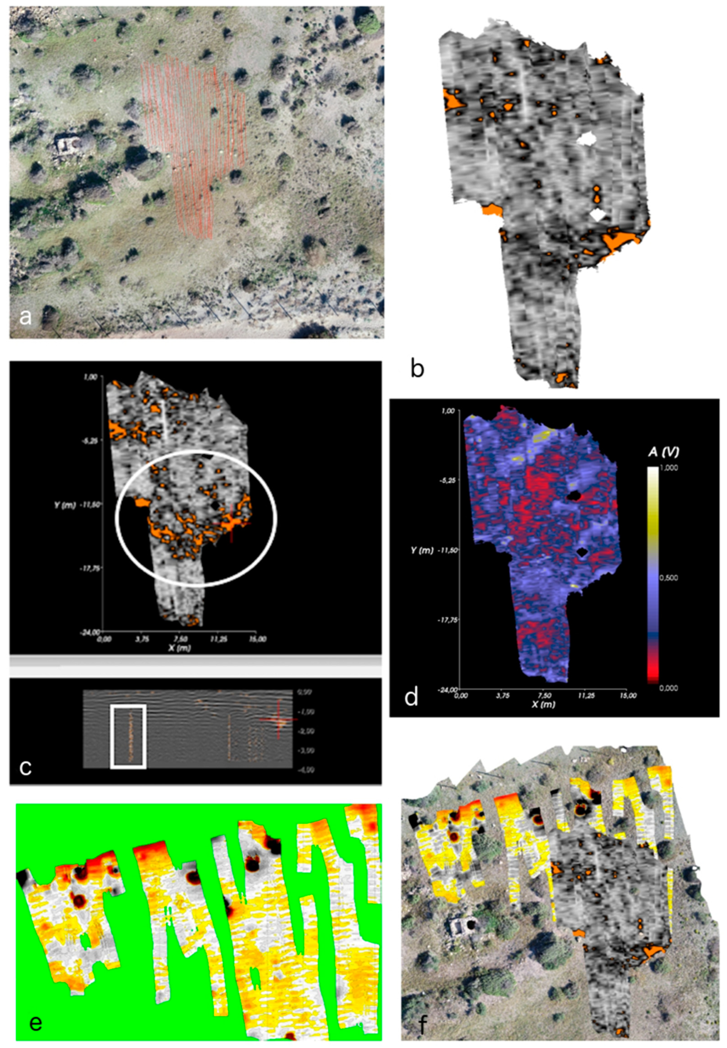
Figure 15.
Details of GPR and Magnetometer scan results. (a–d) different visualisations of the GPR project results with indication of possible borehole (white circle and squares marked on the images); (e) result of the same area from themagnetometer results.
Figure 15.
Details of GPR and Magnetometer scan results. (a–d) different visualisations of the GPR project results with indication of possible borehole (white circle and squares marked on the images); (e) result of the same area from themagnetometer results.
Figure 16.
Details of GPR and Magnetometer scan results. Potential southern enclosure wall of the complex marked by white square.
Figure 16.
Details of GPR and Magnetometer scan results. Potential southern enclosure wall of the complex marked by white square.
Figure 17.
Detailed results of GPR and Magnetometry scans. Potential dumping area marked with a white circle and square.
Figure 17.
Detailed results of GPR and Magnetometry scans. Potential dumping area marked with a white circle and square.
| Disclaimer/Publisher’s Note: The statements, opinions and data contained in all publications are solely those of the individual author(s) and contributor(s) and not of MDPI and/or the editor(s). MDPI and/or the editor(s) disclaim responsibility for any injury to people or property resulting from any ideas, methods, instructions or products referred to in the content. |
© 2023 by the authors. Licensee MDPI, Basel, Switzerland. This article is an open access article distributed under the terms and conditions of the Creative Commons Attribution (CC BY) license (https://creativecommons.org/licenses/by/4.0/).


 ,
, 