


A “Status-Habitat-Potential” Model for the Evaluation of Plant Communities in Underwater Mining Areas via Time Series Remote Sensing Images and GEE


Abstract
:1. Introduction
2. Materials and Methods
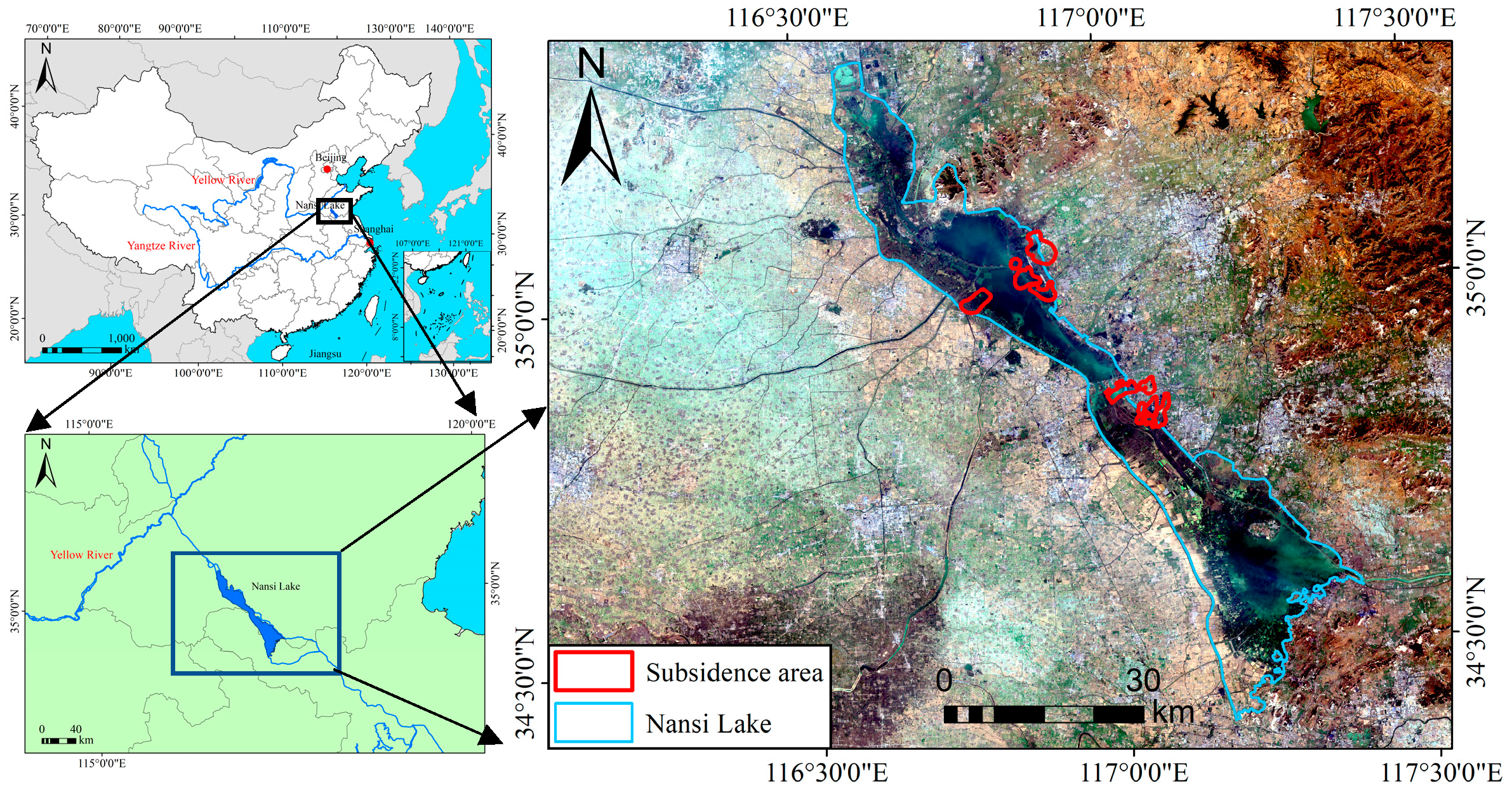
2.1. Study Area
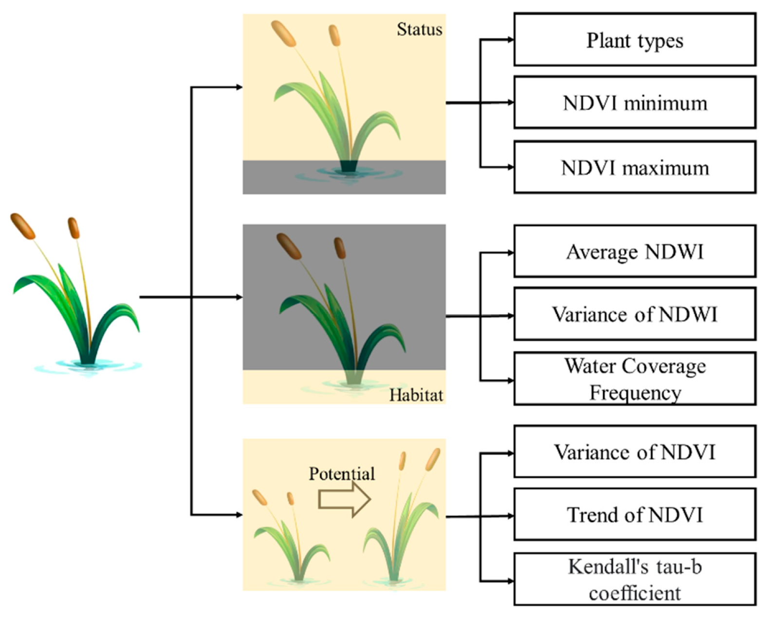
2.2. “Status-Habitat-Potential” Model for Plant Communities
- (1)
- Plant types
- (2)
- NDVI maximum
- (3)
- NDVI minimum
- (4)
- Average NDWI
- (5)
- Variance of NDWI
- (6)
- Water coverage frequency
- (7)
- Variance in NDVI
- (8)
- Trends in NDVI
- (9)
- Kendall’s tau-b rank correlation
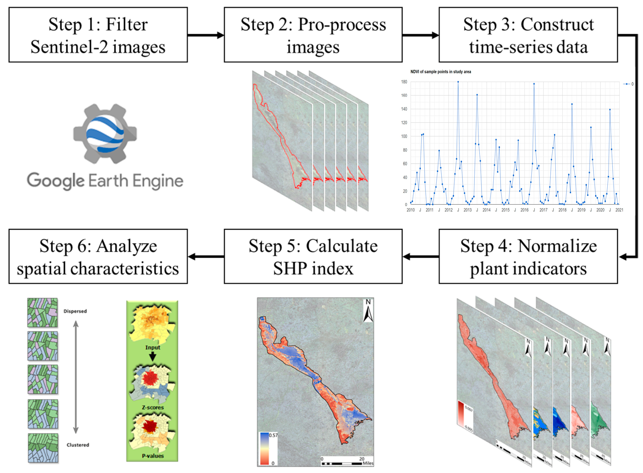
2.3. Acquisition and Analysis of Time Series Remote Sensing Images with GEE
2.4. Statistical and Spatial Analysis
3. Results
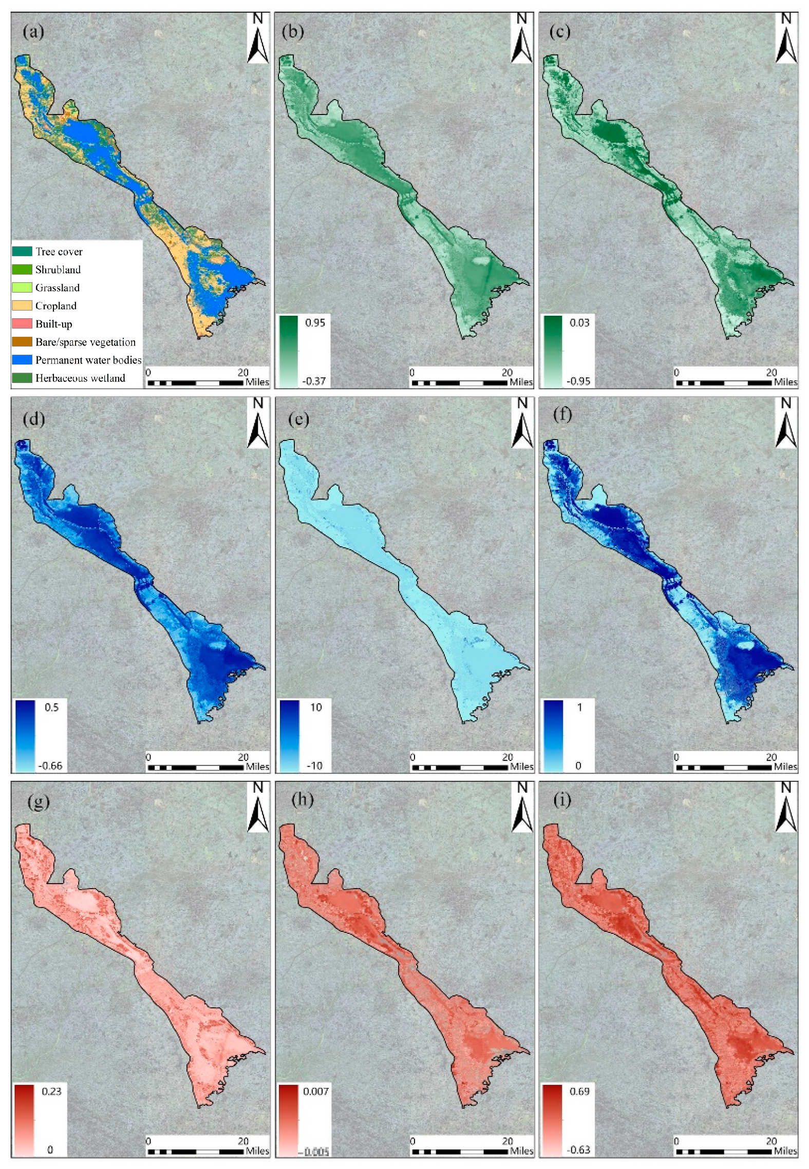
3.1. Status-Habitat-Potential Indicators of Plant Communities in Nansi Lake
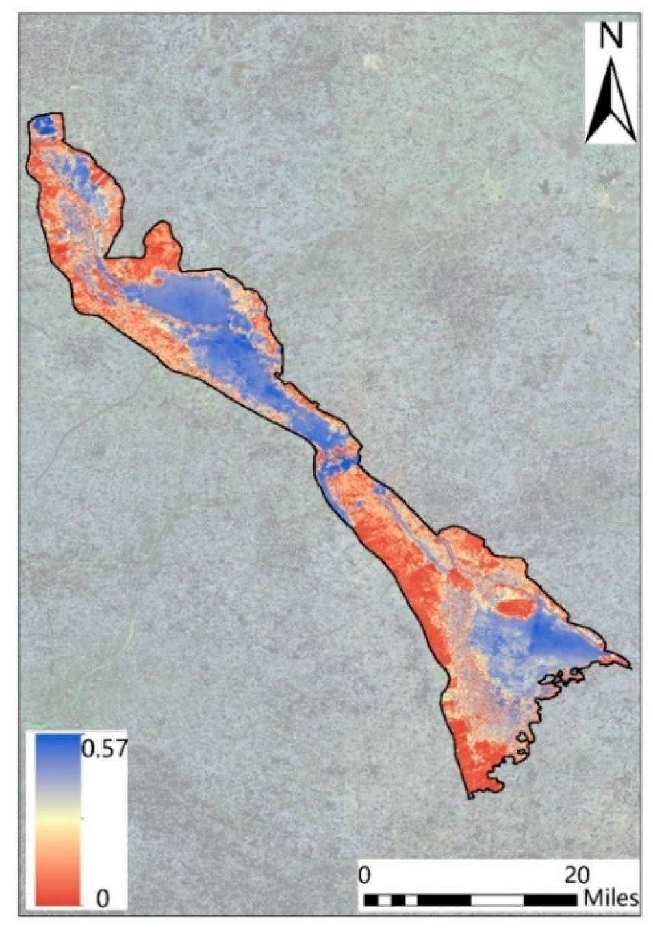
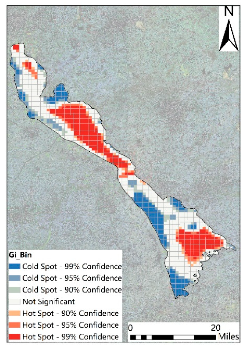
3.2. Distribution and Spatial Characteristics of SHP Index in Nansi Lake
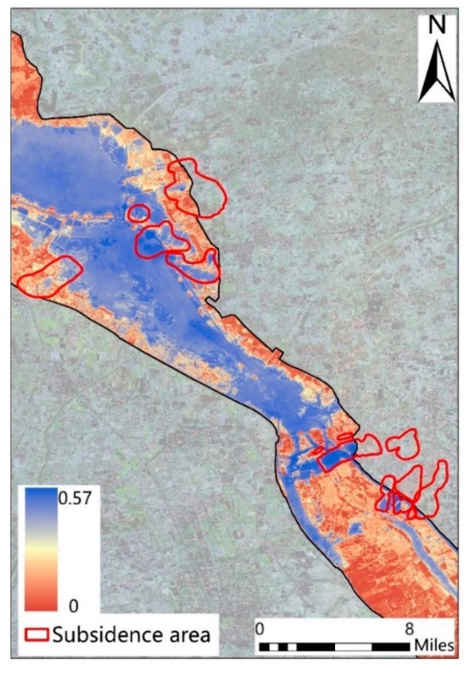
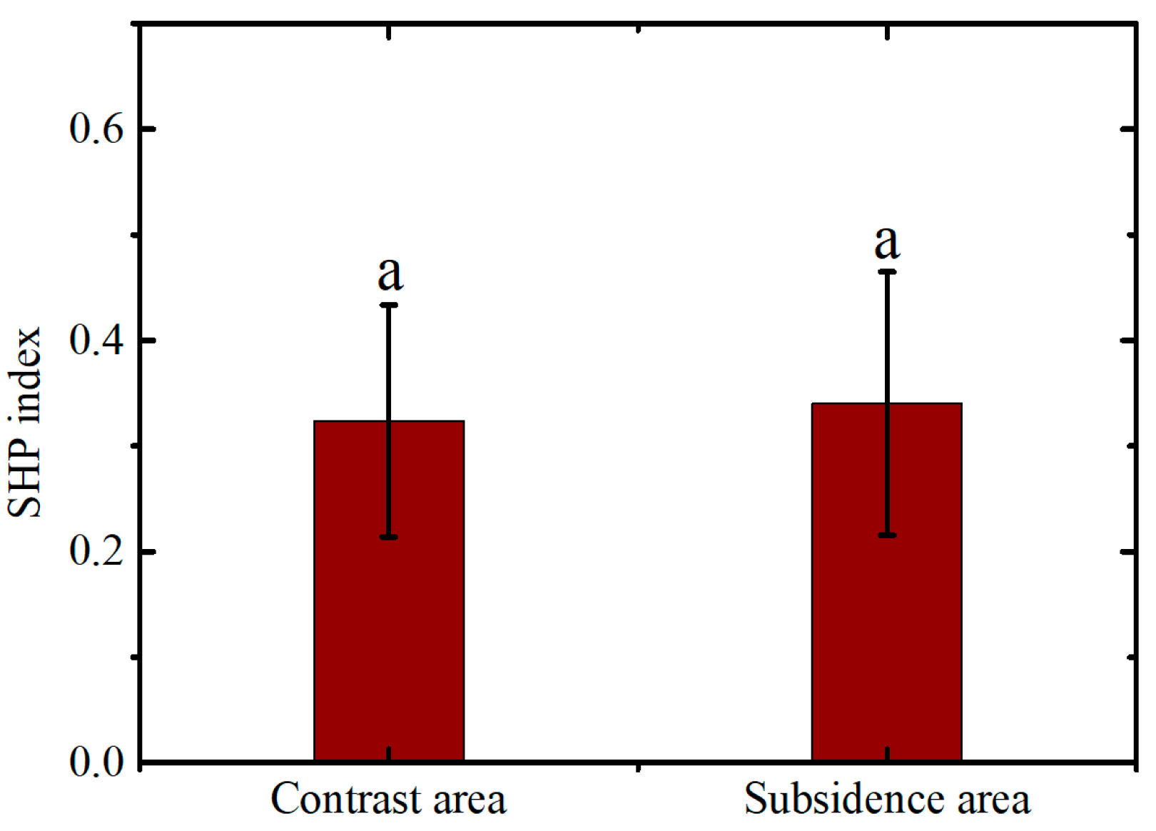
3.3. Comparison of SHP Index between Subsidence and Contrast Areas
4. Discussion
4.1. Effects of Underwater Mining on Plant Communities in Wetland Ecosystems
4.2. Spatial Characteristics of Plant Communities in Underwater Mining Areas and Strategies for Protection
4.3. Potentials for Application of Time Series Images in the Evaluation of Plant Communities
5. Conclusions
Supplementary Materials
Author Contributions
Funding
Data Availability Statement
Conflicts of Interest
References
- Bruno Rocha Martins, W.; Douglas Roque Lima, M.; de Oliveira Barros Junior, U.; Amorim, L.S.V.-B.; de Assis Oliveira, F.; Schwartz, G. Ecological methods and indicators for recovering and monitoring ecosystems after mining: A global literature review. Ecol. Eng. 2020, 145, 105707. [Google Scholar] [CrossRef]
- Mi, J.; Yang, Y.; Hou, H.; Zhang, S.; Ding, Z.; Hua, Y. Impacts of Ground Fissures on Soil Properties in an Underground Mining Area on the Loess Plateau, China. Land 2022, 11, 162. [Google Scholar] [CrossRef]
- Mi, J.; Liu, R.; Zhang, S.; Hou, H.; Yang, Y.; Chen, F.; Zhang, L. Vegetation patterns on a landslide after five years of natural restoration in the Loess Plateau mining area in China. Ecol. Eng. 2019, 136, 46–54. [Google Scholar] [CrossRef]
- Yang, D.; Qiu, H.; Ma, S.; Liu, Z.; Du, C.; Zhu, Y.; Cao, M. Slow surface subsidence and its impact on shallow loess landslides in a coal mining area. Catena 2022, 209, 105830. [Google Scholar] [CrossRef]
- Bi, Y.; Zhang, J.; Song, Z.; Wang, Z.; Qiu, L.; Hu, J.; Gong, Y. Arbuscular mycorrhizal fungi alleviate root damage stress induced by simulated coal mining subsidence ground fissures. Sci. Total Environ. 2019, 652, 398–405. [Google Scholar] [CrossRef]
- Mi, J.; Hou, H.; Zhang, S.; Hua, Y.; Yang, Y.; Zhu, Y.; Ding, Z. Detecting long-term effects of mining-induced ground deformation on plant succession in semi-arid areas using a cellular automata model. Ecol. Indic. 2023, 151, 110290. [Google Scholar] [CrossRef]
- Sun, X.; Yuan, L.; Liu, M.; Liang, S.; Li, D.; Liu, L. Quantitative estimation for the impact of mining activities on vegetation phenology and identifying its controlling factors from Sentinel-2 time series. Int. J. Appl. Earth Obs. Geoinf. 2022, 111, 102814. [Google Scholar] [CrossRef]
- Dolný, A.; Harabiš, F. Underground mining can contribute to freshwater biodiversity conservation: Allogenic succession forms suitable habitats for dragonflies. Biol. Conserv. 2012, 145, 109–117. [Google Scholar] [CrossRef]
- Pierzchala, L.; Sierka, E. Do submerged plants improve the water quality in mining subsidence reservoirs? Appl. Ecol. Environ. Res. 2020, 18, 5661–5672. [Google Scholar] [CrossRef]
- Ciszewski, D.; Sobucki, M. River response to mining-induced subsidence. Catena 2022, 214, 106303. [Google Scholar] [CrossRef]
- Antwi, E.K.; Krawczynski, R.; Wiegleb, G. Detecting the effect of disturbance on habitat diversity and land cover change in a post-mining area using GIS. Landsc. Urban Plan. 2008, 87, 22–32. [Google Scholar] [CrossRef]
- Hou, H.; Ding, Z.; Zhang, S.; Chen, Z.; Wang, X.; Sun, A.; An, S.; Xiong, J. Targeting the Influences of Under-Lake Coal Mining Based on the Value of Wetland Ecosystem Services: What and How? Land 2022, 11, 2166. [Google Scholar] [CrossRef]
- Casanova, M.T.; Brock, M.A. How do depth, duration and frequency of flooding influence the establishment of wetland plant communities? Plant Ecol. 2000, 147, 237–250. [Google Scholar] [CrossRef]
- Dong, B.; Qin, B.; Gao, G.; Cai, X. Submerged macrophyte communities and the controlling factors in large, shallow Lake Taihu (China): Sediment distribution and water depth. J. Great Lakes Res. 2014, 40, 646–655. [Google Scholar] [CrossRef]
- Stoof-Leichsenring, K.R.; Dulias, K.; Biskaborn, B.K.; Pestryakova, L.A.; Herzschuh, U. Lake-depth related pattern of genetic and morphological diatom diversity in boreal Lake Bolshoe Toko, Eastern Siberia. PLoS ONE 2020, 15, e0230284. [Google Scholar] [CrossRef]
- Xiao, W.; Zheng, W.; Zhao, Y.; Chen, J.; Hu, Z. Examining the relationship between coal mining subsidence and crop failure in plains with a high underground water table. J. Soils Sediments 2021, 21, 2908–2921. [Google Scholar] [CrossRef]
- Guzy, A.; Malinowska, A.A. Assessment of the Impact of the Spatial Extent of Land Subsidence and Aquifer System Drainage Induced by Underground Mining. Sustainability 2020, 12, 7871. [Google Scholar] [CrossRef]
- Ma, L.; Jin, Z.; Liang, J.; Sun, H.; Zhang, D.; Li, P. Simulation of water resource loss in short-distance coal seams disturbed by repeated mining. Environ. Earth Sci. 2015, 74, 5653–5662. [Google Scholar] [CrossRef]
- Salimi, S.; Almuktar, S.A.; Scholz, M. Impact of climate change on wetland ecosystems: A critical review of experimental wetlands. J. Environ. Manag. 2021, 286, 112160. [Google Scholar] [CrossRef]
- Cao, B.; Bai, C.; Xue, Y.; Yang, J.; Gao, P.; Liang, H.; Zhang, L.; Che, L.; Wang, J.; Xu, J.; et al. Wetlands rise and fall: Six endangered wetland species showed different patterns of habitat shift under future climate change. Sci. Total Environ. 2020, 731, 138518. [Google Scholar] [CrossRef]
- Liu, Q.; Liu, J.; Liu, H.; Liang, L.; Cai, Y.; Wang, X.; Li, C. Vegetation dynamics under water-level fluctuations: Implications for wetland restoration. J. Hydrol. 2020, 581, 124418. [Google Scholar] [CrossRef]
- Li, Y.; Qian, F.; Silbernagel, J.; Larson, H. Community structure, abundance variation and population trends of waterbirds in relation to water level fluctuation in Poyang Lake. J. Great Lakes Res. 2019, 45, 976–985. [Google Scholar] [CrossRef]
- Hiatt, M.; Snedden, G.; Day, J.W.; Rohli, R.V.; Nyman, J.A.; Lane, R.; Sharp, L.A. Drivers and impacts of water level fluctuations in the Mississippi River delta: Implications for delta restoration. Estuar. Coast. Shelf Sci. 2019, 224, 117–137. [Google Scholar] [CrossRef]
- Mu, S.; Li, B.; Yao, J.; Yang, G.; Wan, R.; Xu, X. Monitoring the spatio-temporal dynamics of the wetland vegetation in Poyang Lake by Landsat and MODIS observations. Sci. Total Environ. 2020, 725, 138096. [Google Scholar] [CrossRef] [PubMed]
- Wei, G.-W.; Chen, Y.; Sun, X.-S.; Chen, Y.-H.; Luo, F.-L.; Yu, F.-H. Growth responses of eight wetland species to water level fluctuation with different ranges and frequencies. PLoS ONE 2019, 14, e0220231. [Google Scholar] [CrossRef] [PubMed]
- Yin, D.; Peng, F.; He, T.; Xu, Y.; Wang, Y. Ecological risks of heavy metals as influenced by water-level fluctuations in a polluted plateau wetland, southwest China. Sci. Total Environ. 2020, 742, 140319. [Google Scholar] [CrossRef]
- Tajduś, K.; Sroka, A.; Misa, R.; Hager, S.; Rusek, J.; Dudek, M.; Wollnik, F. Analysis of Mining-Induced Delayed Surface Subsidence. Minerals 2021, 11, 1187. [Google Scholar] [CrossRef]
- Chang, C.C.; Turner, B.L. Ecological succession in a changing world. J. Ecol. 2019, 107, 503–509. [Google Scholar] [CrossRef]
- Vorovencii, I. Changes detected in the extent of surface mining and reclamation using multitemporal Landsat imagery: A case study of Jiu Valley, Romania. Environ. Monit. Assess. 2021, 193, 30. [Google Scholar] [CrossRef]
- Zhang, M.; Wang, J.; Li, S. Tempo-spatial changes and main anthropogenic influence factors of vegetation fractional coverage in a large-scale opencast coal mine area from 1992 to 2015. J. Clean. Prod. 2019, 232, 940–952. [Google Scholar] [CrossRef]
- Huang, Y.; Tian, F.; Wang, Y.; Wang, M.; Hu, Z. Effect of coal mining on vegetation disturbance and associated carbon loss. Environ. Earth Sci. 2015, 73, 2329–2342. [Google Scholar] [CrossRef]
- Lee, J.; Li, S. Extending Moran’s Index for Measuring Spatiotemporal Clustering of Geographic Events. Geogr. Anal. 2017, 49, 36–57. [Google Scholar] [CrossRef]
- Wulff, A.S.; Hollingsworth, P.M.; Ahrends, A.; Jaffré, T.; Veillon, J.-M.; L’huillier, L.; Fogliani, B. Conservation Priorities in a Biodiversity Hotspot: Analysis of Narrow Endemic Plant Species in New Caledonia. PLoS ONE 2013, 8, e73371. [Google Scholar] [CrossRef] [PubMed]
- Mi, J.; Yang, Y.; Hou, H.; Zhang, S.; Raval, S.; Chen, Z.; Hua, Y. The long-term effects of underground mining on the growth of tree, shrub, and herb communities in arid and semiarid areas in China. Land Degrad. Dev. 2021, 32, 1412–1425. [Google Scholar] [CrossRef]
- Liu, S.; Li, W.; Qiao, W.; Wang, Q.; Hu, Y.; Wang, Z. Effect of natural conditions and mining activities on vegetation variations in arid and semiarid mining regions. Ecol. Indic. 2019, 103, 331–345. [Google Scholar] [CrossRef]
- Yang, Z.; Li, W.; Li, X.; He, J. Quantitative analysis of the relationship between vegetation and groundwater buried depth: A case study of a coal mine district in Western China. Ecol. Indic. 2019, 102, 770–782. [Google Scholar] [CrossRef]
- Speed, J.D.; Cooper, E.J.; Jónsdóttir, I.S.; Van Der Wal, R.; Woodin, S.J. Plant community properties predict vegetation resilience to herbivore disturbance in the Arctic. J. Ecol. 2010, 98, 1002–1013. [Google Scholar] [CrossRef]
- Qin, B.; Gao, G.; Zhu, G.; Zhang, Y.L.; Song, Y.Z.; Tang, X.M.; Xu, H.; Deng, J.M. Lake eutrophication and its ecosystem response. Chin. Sci. Bull. 2013, 58, 961–970. [Google Scholar] [CrossRef]
- Seopela, M.P.; McCrindle, R.I.; Combrinck, S.; Regnier, T.J.-C. Hazard assessment of polycyclic aromatic hydrocarbons in water and sediment in the vicinity of coalmines. J. Soils Sediments 2016, 16, 2740–2752. [Google Scholar] [CrossRef]
- Chen, D.; Feng, Q.; Liang, H.; Gao, B.; Alam, E. Distribution characteristics and ecological risk assessment of polycyclic aromatic hydrocarbons (PAHs) in underground coal mining environment of Xuzhou. Hum. Ecol. Risk Assess. Int. J. 2019, 25, 1564–1578. [Google Scholar] [CrossRef]
- Sitch, S.; Smith, B.; Prentice, I.C.; Arneth, A.; Bondeau, A.; Cramer, W.; Kaplan, J.O.; Levis, S.; Lucht, W.; Sykes, M.T.; et al. Evaluation of ecosystem dynamics, plant geography and terrestrial carbon cycling in the LPJ dynamic global vegetation model. Glob. Chang. Biol. 2003, 9, 161–185. [Google Scholar] [CrossRef]
- Villoslada, M.; Bergamo, T.F.; Ward, R.D.; Burnside, N.; Joyce, C.; Bunce, R.; Sepp, K. Fine scale plant community assessment in coastal meadows using UAV based multispectral data. Ecol. Indic. 2020, 111, 105979. [Google Scholar] [CrossRef]
- Lee, C.K.; Nicholson, E.; Duncan, C.; Murray, N.J. Estimating changes and trends in ecosystem extent with dense time-series satellite remote sensing. Conserv. Biol. 2021, 35, 325–335. [Google Scholar] [CrossRef] [PubMed]
- Xu, H.; Wang, Y.; Guan, H.; Shi, T.; Hu, X. Detecting Ecological Changes with a Remote Sensing Based Ecological Index (RSEI) Produced Time Series and Change Vector Analysis. Remote Sens. 2019, 11, 2345. [Google Scholar] [CrossRef]
- Sandeep, P.; Obi Reddy, G.P.; Jegankumar, R.; Kumar, K.A. Monitoring of agricultural drought in semi-arid ecosystem of Peninsular India through indices derived from time-series CHIRPS and MODIS datasets. Ecol. Indic. 2021, 121, 107033. [Google Scholar] [CrossRef]
- De Keersmaecker, W.; Lhermitte, S.; Honnay, O.; Farifteh, J.; Somers, B.; Coppin, P. How to measure ecosystem stability? An evaluation of the reliability of stability metrics based on remote sensing time series across the major global ecosystems. Glob. Chang. Biol. 2014, 20, 2149–2161. [Google Scholar] [CrossRef]

| Types | Scores |
|---|---|
| Tree cover | 1 |
| Shrubland | 0.8 |
| Grassland | 0.6 |
| Cropland | 0 |
| Built-up | 0 |
| Bare/sparse vegetation | 0.2 |
| Permanent water bodies | 0.4 |
| Herbaceous wetland | 0.8 |
| Indicators | F1 | F2 | F3 | F4 | F5 | F6 | F7 | F8 | F9 |
| Weights | 0.12 | 0.11 | 0.08 | 0.11 | 0.12 | 0.11 | 0.12 | 0.12 | 0.12 |
| Indices | Values |
|---|---|
| Global Moran’s I | 0.41 |
| z score | 456.32 |
| p | 0 |
Disclaimer/Publisher’s Note: The statements, opinions and data contained in all publications are solely those of the individual author(s) and contributor(s) and not of MDPI and/or the editor(s). MDPI and/or the editor(s) disclaim responsibility for any injury to people or property resulting from any ideas, methods, instructions or products referred to in the content. |
© 2023 by the authors. Licensee MDPI, Basel, Switzerland. This article is an open access article distributed under the terms and conditions of the Creative Commons Attribution (CC BY) license (https://creativecommons.org/licenses/by/4.0/).
Share and Cite
Mi, J.; Yang, D.; Hou, H.; Zhang, S. A “Status-Habitat-Potential” Model for the Evaluation of Plant Communities in Underwater Mining Areas via Time Series Remote Sensing Images and GEE. Land 2023, 12, 2097. https://doi.org/10.3390/land12122097
Mi J, Yang D, Hou H, Zhang S. A “Status-Habitat-Potential” Model for the Evaluation of Plant Communities in Underwater Mining Areas via Time Series Remote Sensing Images and GEE. Land. 2023; 12(12):2097. https://doi.org/10.3390/land12122097
Chicago/Turabian StyleMi, Jiaxin, Deli Yang, Huping Hou, and Shaoliang Zhang. 2023. "A “Status-Habitat-Potential” Model for the Evaluation of Plant Communities in Underwater Mining Areas via Time Series Remote Sensing Images and GEE" Land 12, no. 12: 2097. https://doi.org/10.3390/land12122097
APA StyleMi, J., Yang, D., Hou, H., & Zhang, S. (2023). A “Status-Habitat-Potential” Model for the Evaluation of Plant Communities in Underwater Mining Areas via Time Series Remote Sensing Images and GEE. Land, 12(12), 2097. https://doi.org/10.3390/land12122097