Article

Effects of Mosaic Natural Conditions on the Tourism Management of a Lowland Water Reservoir, Lake Tisza, Hungary

1
Department of Landscape Protection and Environmental Geography, Institute of Earth Sciences, Faculty of Science and Technology, University of Debrecen, 4032 Debrecen, Hungary
2
Department of Data Science and Visualization, Faculty of Informatics, University of Debrecen, 4023 Debrecen, Hungary
*
Author to whom correspondence should be addressed.
Land 2023, 12(12), 2092; https://doi.org/10.3390/land12122092
Submission received: 27 October 2023 / Revised: 14 November 2023 / Accepted: 17 November 2023 / Published: 21 November 2023
(This article belongs to the Special Issue Landscape-Scale Sustainable Tourism Development)

Abstract

:
The increasing number of visitors and conflicts resulting from shared use in valorising sensitive wetlands make effective visitor and site management measures essential. In the course of this research, the landscape pattern, the current spatial distribution of tourist activities and the possible arrangement of expedient further development were examined. The study area, Lake Tisza, is an artificial lowland reservoir established in the 1970s with an area of 127 km2 in Hungary. Among its original functions, in addition to flood control, nature conservation and recreation have become the main profiles. The diverse hydro-ecological features and mosaic landscape structure allow for nature conservation and utilisation in tourism. This differentiated use is in line with the worldwide trend of favouring locations with multiple leisure activities in close proximity to each other. Based on the CORINE Land Cover (CLC) 2018 database, 12 different land use categories were identified in the study area. The largest proportion is represented by water bodies (53.29%), while inland marshes and broad-leaved forests cover 22.25% and 16.64%, respectively. The heterogeneity of the area is considerably enhanced by the high patch sizes of the categories pastures, broad-leaved forests and inland marshes. According to the Shannon diversity index, the most complex landscape diversity can be found in the Tiszavalk (1.5) and Poroszló (1.4) basins, considered to be the most suitable for ecotourism, while the lower values of the Sarud (1.1) and Abadszalók (1.1) basins provide suitable conditions for water sport activities and recreational tourism. Continuous adaptation to social needs and the joint protection of natural values is crucial for the sustainable development of Lake Tisza.

1. Introduction

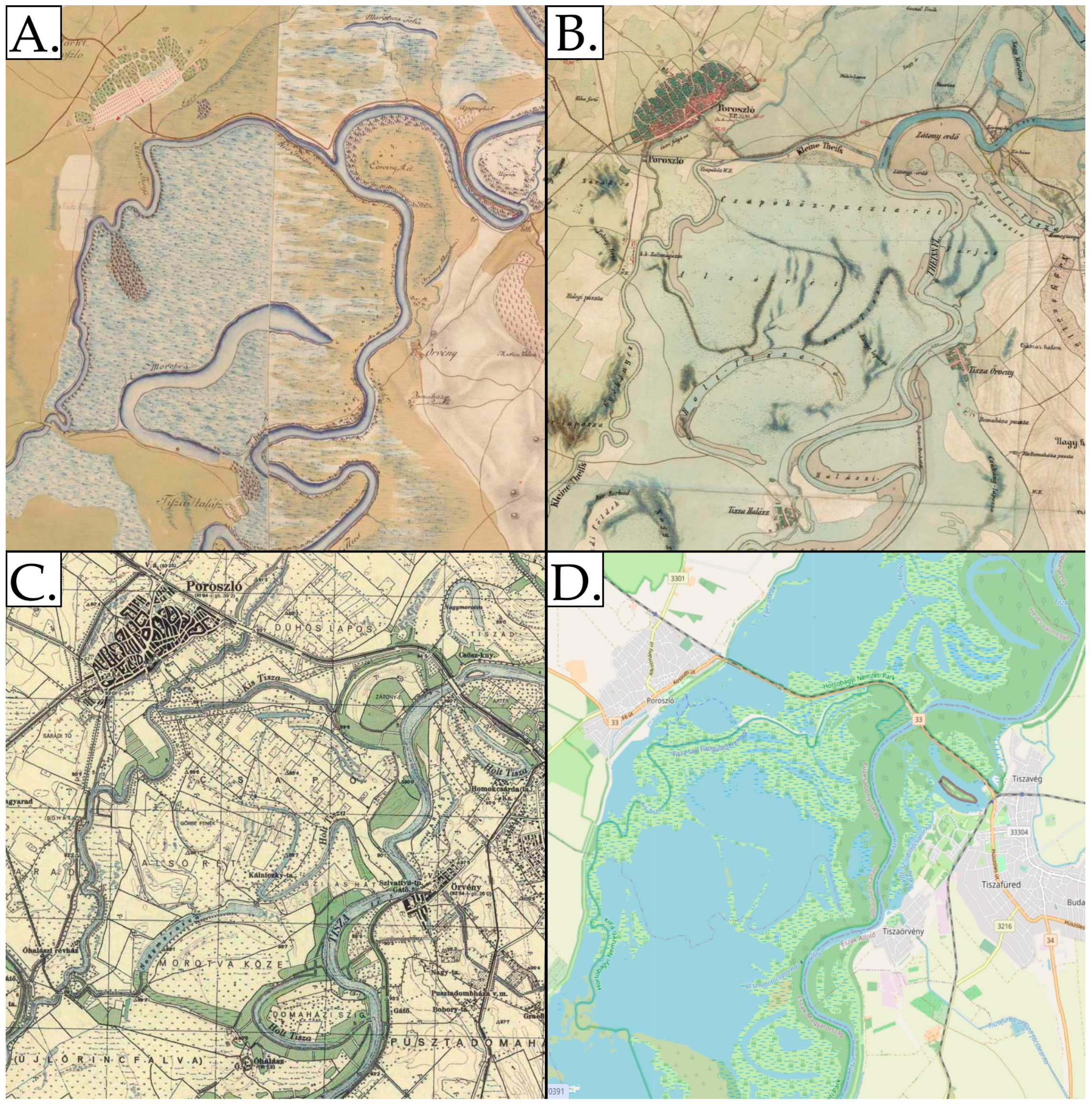
1.1. Historical Backround of Land Use Changes in the Middle Tisza Region

Land use planning always tries to follow the constantly changing needs of society [1]. Sometimes, a previous anthropogenic intervention should be partially reversed because the old landscape type would be better for the new needs [2]. This happened in the central plain of the Carpathian Basin, the Great Plain, which until the 18th century was a free floodplain of the Tisza and its tributaries, where floods affected an area of several hundred km2. In the 19th century, the rivers were dammed, and the exempted floodplains were used for arable agriculture [3]. However, the fertility of the land obtained in this way is relatively poor, salinification appeared and production was not economical in many places by the end of the 20th century. The economic development of the Tisza region has stalled and the number of its inhabitants has started to decline. The remaining arable land requires an increasing amount of irrigation water, cumulative use has increased and there is also great interest in coastal recreation. In the meantime, social thinking has changed, and nature-friendly use has gained ground, which encourages the partial rehabilitation of the once-extensive wet habitats [4].
River regulation in the 19th century, dam construction and cutting river bends caused many conflicts among land owners [5]. In contrast, at the turn of the 20th century, the designation of nature reserves did not cause serious harm to interests, because in the decades between 1960 and 1990, the middle Tisza region was a depopulated, economically depressed region, and the lands were state-owned. The local population had no say in the designation of nature reserves.
It was in such a social, economic and ownership situation that the most spectacular water management intervention in the Great Plain, the establishment of Lake Tisza, took place between 1967 and 1980. As we shall see later, efforts were made already in the design phase to meet a variety of needs. Even today, it is necessary to find a land use structure that allows space for new developments, recreation, nature conservation and water management. Fortunately, due to its size (127 km2) and relatively diverse natural conditions, Lake Tisza provides an opportunity to develop a diverse usage pattern across the space and over time.
Landscape mosaics is a landscape structure that significantly influences the operation, use and aesthetic appearance of the landscape [6,7,8,9,10]. Therefore, analysing spatial diversity is considered to be an important goal for landscape geography, landscape ecology, landscape character and aesthetics research as well [11,12,13,14,15,16].

1.2. Natural and Land Use Diversity

Traditional landscape geography discusses the diversity of landscape patterns based on natural differences in landscape factors (geology, topography, climate, hydrography, soil, vegetation). The natural diversity of the Carpathian Basin is very high, due to the boundaries between the climatic, soil and biogeographical conditions of the W, S and E parts of the continent. The geographical zonality typical of an Eastern European plain switches here to the mosaic landscape structure of Western Europe. Traditional European land use adapted very precisely to minor microclimate, soil and hydrographic differences before extended afforestation, the formation of plantations and the mechanisation and chemisation of agriculture. For this reason, land use and landscape diversity in Europe were probably greatest in the mid-19th century [17,18]. As a result of afforestation in the 20th century, increasing arable land plots and sometimes monocultural vineyards and fruit plantations, the landscape diversity of the continent has decreased significantly [13,19]. The mosaic character of landscapes, however, has started to grow again in the last few decades as the proportion of arable cultivation has decreased significantly, nature reserves have increased and cultural landscapes are rapidly urbanizing. Practically, a strong land use polarization is going on; on the one hand, the proportion of built-up areas is almost 10% in the W and S parts of the continent, and on the other hand, the share of semi-natural areas is 15–20% [20]. The size of the habitats (ecotops) is decisive in the landscape structure from an ecological point of view; however, soil erosion is also influenced by the spatial distribution of dense vegetation, reducing run-off.
The heterogeneity of landscapes is expressed in mosaics, the basic units of which are patches, corridors and a matrix. The unique characteristics and indices of these landscape elements are expressed in quantitative form in landscape metrics [21]. Landscape metrics research usually makes patches the object of investigation, since their geometric properties (area, perimeter, shape, etc.) and their relative spatial location (e.g., proximity of spots, connectivity) can be calculated simply and mathematically [22]. If this pattern has developed naturally, it is known as mosaics, but if the pattern is caused by human activities, it is called fragmentation [23]. The landscape pattern can be characterised based on geoinformatic methods, mathematical models [10] or landscape metric data, such as mean patch size (MPS), mean shape index (MSI), concavity (CNCV), mean nearest neighbour (MNN), the Shannon diversity index (SHDI), etc. [24,25,26].

1.3. Visual Diversity and Landscape Aesthetics
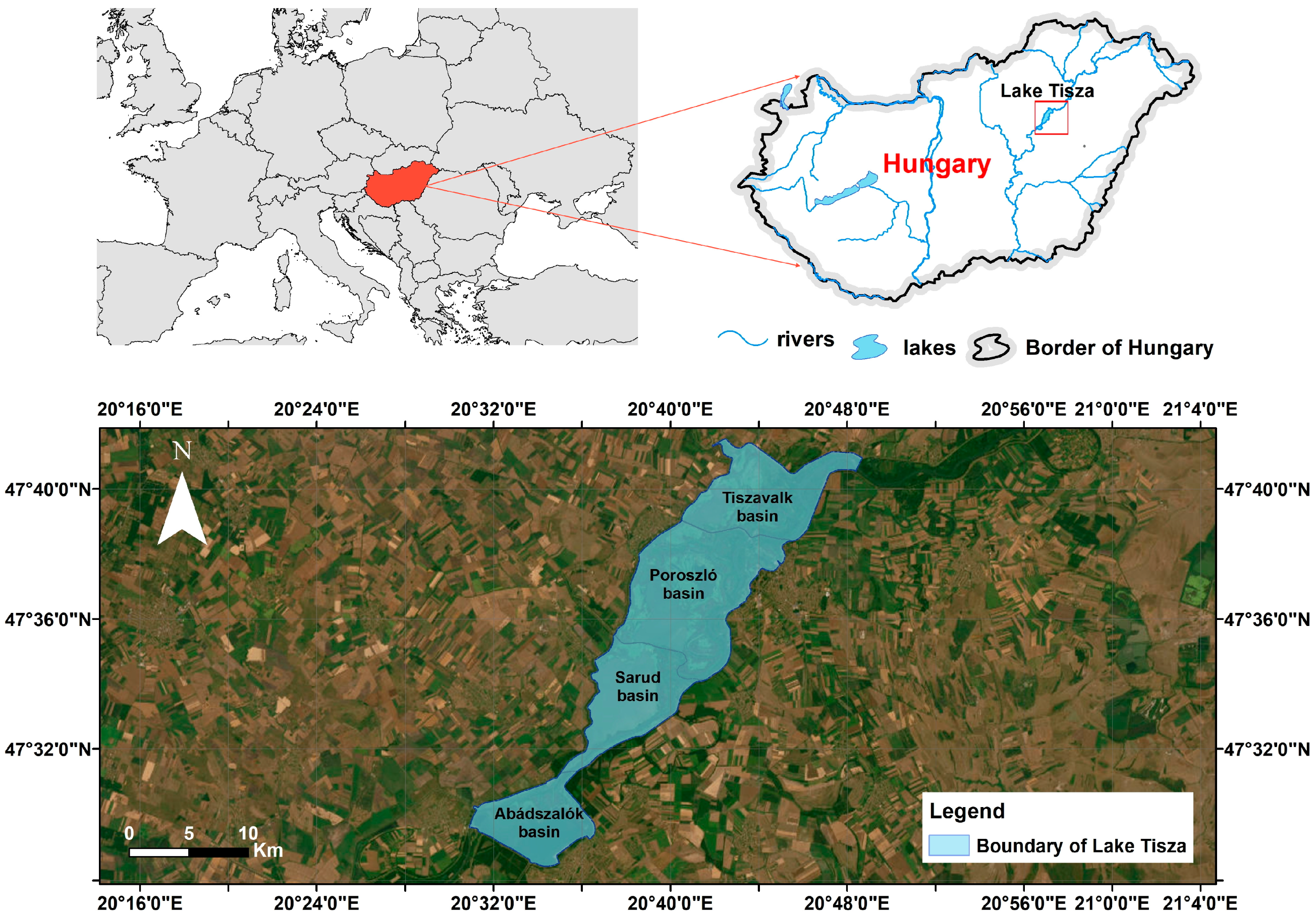
The mosaics in the visual image of a landscape are determined mainly by the spatial pattern of the relief, vegetation cover, built-up areas and water surfaces. The scenery is generally characterised by the perception and harmony of different land use patches [27,28,29]. The aesthetic image of the landscape is strongly subjective; however, the average grade of likeness of the scenery can be determined based on an adequately large number of subjective opinions.
The attractiveness of landscape scenery and knowing the preferred landscape pattern are important information for tourism. Numerous surveys indicate that after historical places, scenic, well-kept, harmonic landscapes have the greatest attraction for visitors [30,31,32]. Most visitors would not like to see weedy fallow lands, eroded slopes and shaggy scrubs but rather peaceful grazing cattle, freshly mown meadows, attractive tree avenues, woodlands with variable size and species compositions and flowing or standing waters [33,34,35]. Mosaics is a key factor in the emotional impact of landscapes [13,36]. Several European surveys confirm that agricultural parcels, tree avenues, scattered groups of trees and mosaic landscapes of various shapes, colours and sizes, with some water surfaces, are the most popular [37,38]. Ref. [39] divided the structural elements of the landscape into three groups; linear elements, point elements and patch surfaces. Of these, point-like and green landscape patches evoke the most positive aesthetic effects; however, landscapes with hedgerows are also highly popular [40]. Some analyses also showed that views with a moderate number of patches that were not too diverse had the greatest effect on observers [41,42]. Authors often point out that factors that are difficult to quantify and can be detected only occasionally, e.g., seasonally, contribute to the favourable aesthetic assessment of a landscape, such as the sounds of nature (rustling leaves, babbling water); the smell of a landscape; luminous and shadow phenomena, meteorological and atmospheric effects, e.g., the Northern Lights; etc. [43]. Several surveys have confirmed that the increase in homogeneity of European landscapes, i.e., regular squares of growing arable land plots, vineyards or dense afforestation (e.g., energy forests), generally does not appeal to locals or tourists [44,45,46].
The open or closed nature of a landscape and the quality of visibility and view play an important role in judging the scenery of the landscape [47,48]. In flat areas, the feeling of spaciousness is significantly increased by the sky and water surfaces [49]. The shores of lakes, rivers and seas are key elements of the attractiveness of the landscape. This is one of the oldest landscape aesthetic statements that is still true today [50,51,52,53]. Along shores, mosaic plant cover and built-up areas are considered optimal both ecologically and aesthetically [54,55,56,57].
The increasing number of visitors and conflicts resulting from shared use in valorising sensitive wetlands make effective visitor and site management measures essential. In the course of this research, the landscape pattern, the current spatial distribution of tourist activities and the possible arrangement of expedient further development were examined. In recent years, rapid changes in societal needs accelerated by the effects of climate change and urbanization have led to the increased importance of wetland areas for recreation, which presents a constant challenge to landscape planning. One tool for managing recreational activities and tourism is ecosystem-based zoning [58,59]. It is used not only in terrestrial protected areas [60,61] but in marine systems as well [62,63].
The aim of this study is to evaluate the landscape mosaic character, the spatial patterns of recreation and nature conservation in the context of tourism management on the example of Lake Tisza. This integrated approach highlights how natural conditions can enhance sustainable tourism development in the 21st century. The novelty of our research lies in the fact that zonal visitor management of lake ecosystems has not been widely used in practice at present and is completely lacking in Hungary, so our study can be an important addition to the literature and a useful tool for practitioners. Moreover, the results of this paper could help decision-makers to justify the direction of future developments of wetland areas with similar characteristics.

2. Study Area

2.1. Geographical Properties

Lake Tisza has the third largest water surface area in the Carpathian Basin. It is located in the middle of the Great Plain (Figure 1). The central, deepest part of the basin was a real “wildwater land”, mostly undisturbed before river regulations in the 19th century (Figure 2).
The establishment of the lake started in 1967 and the following objectives were set at that time in the order of importance:
-
Providing a constant water level for a power plant nearby and for the hydroelectric power plant at the southern edge of the lake,
-
Irrigation of the surrounding agricultural areas,
-
Providing flood protection and shipping,
-
Recreation, easing the increasing crowdedness of Lake Balaton, the most popular even at that time, by creating a new lake.
Fifty years ago, Lake Tisza and its surroundings were considered the internal periphery of Hungary with poor infrastructure and few industrial plants. Inhabitants lived on agriculture; however, the productivity of the land here is only moderate due to climatic reasons and soil properties. The region was characterized by high unemployment, emigration and ageing. Under these circumstances, the idea of developing tourism in the late 1960s was a very progressive step. The area around the lake was declared a resort area in 1975. According to tourism statistics [64], between 2016 and 2020, 350,000 guest nights were registered annually in a region of less than 30,000 inhabitants. About 1000 accommodations can be found around the lake, mostly pensions and guesthouses for five to eight people.
Among the originally planned functions, flood protection has become more important due to climate change, combined with increasingly extreme water conditions. However, there has been no demand for water freight transport since then, and between 2000 and 2020, the amount of irrigated land in Hungary also decreased by 15% [65]. The mentioned thermal power plant was shut down in 2013, but the hydroelectric power station is operating. Overall, recreation came out on top among the former goals.
The lake is completely surrounded by an embankment, which rises 3–4 m above the water level of the lake. At the top of the embankment, there is a single-lane concrete road. Car travel is allowed on this, subject to a small fee.
The length of the cycling route, which skips the northern part, is 64 km running mainly along the crown of the embankment. One advantageous feature of the lake is that only about 15% of the outer side of the circular embankment is in contact with the settlement. A total of two small towns and two villages are in contact with the embankment, and another five villages are 2–3 km away from the embankment. Built-up areas along the direct shore (within the embankment) are minimal, only associated with the nine marinas, campsites and beaches there are across some 100 m of covered shoreline.

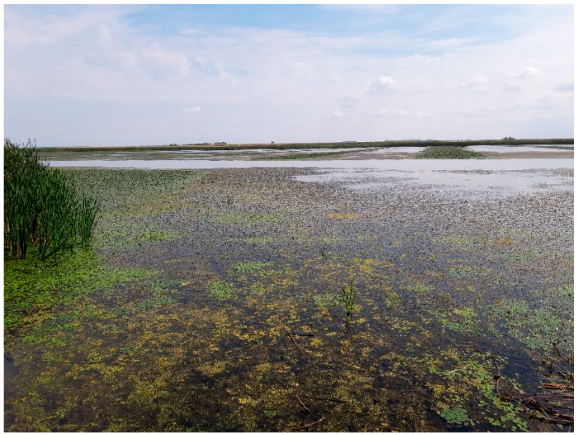
2.2. Ecological Endowments

After the construction of the embankment and the hydroelectric power station at the lower end, it took 5 years to fill the lake (1973–1978). Lake Tisza with an area of 127 km2 is a shallow lowland reservoir, which warms up to 25 °C in summer. The so-called flow-through water mass, the so-called “living” Tisza, stretches slightly west from the axis line of today’s lake (Figure 3).
The basin of the lake is dissected geomorphologically, and the topography of the former floodplain, natural levees, islands, oxbow lakes and canals can be detected even today; therefore, the lake can be divided into four distinct parts. From N to S, there are the sub-basins (bays) of Tiszavalk, Poroszló, Sarud and Abádszalók (Figure 1 and Figure 3).
In the bays furthest from the fresh water of the Tisza, the waterflow is very slow, almost stagnant in some places. The water level in the lake is regulated seasonally with the help of the locks of the hydropower plant. For nature conservation and recreation purposes, high water levels are maintained in spring and summer, although this is not always possible due to intensifying summer droughts. In August 2022, for example, 1/3 of the tourist shipping waterway had to be closed due to the low water depth. In late autumn, a planned water level decrease of 80–100 cm is carried out, when 43 km2 of the 127 km2 of the lakebed becomes dry. During the rapid 1-week lowering of the water level in autumn, a lot of accumulated sediment drifts out of the sub-basins; therefore, the water of the lake will be cleaner during the recharge in the following spring. The average water depth in summer is slightly below 1 m in the N part of the lake and over 2 m in the S part of the lake. However, in the strip of the original riverbed and former oxbow lakes, it exceeds 5–10 m (Table 1). Due to significant fluctuations in water depth and the area covered by water, seasonal vegetation dynamics show a picture similar to the natural conditions before river regulations [67].
Maintaining the full potential for ecological diversity in the long term, especially in the context of climate change, is difficult. Nature conservation is also forced to set certain priorities [63,69,70]. This is why, e.g., bird protection areas have been designated, while elsewhere, the conservation of bog vegetation is the primary conservation objective. When the northern and central parts of Lake Tisza, about 65% of the area, became part of the Hortobágy National Park in 1993, a zone system for the utilisation of the lake was established in order to separate nature protection from other, primarily touristic and recreational, use. Around the turn of the millennium, mosaic-based zoning was applied to several similar European wetlands and artificial lakes as well [71,72,73,74,75].

2.3. Types of Recreation

Several types of tourism-related activities are present in the study area. Bathing has been the most common touristic use of the lake since its inception. According to surveys, about 10,000 bathers enjoy the water of the lake on a hot weekend. As a result of developments, the number of cyclists is constantly increasing. In 2021, sensors installed along the embankment reached a peak in measured data following the COVID-19 pandemic, recording a total of about 88,000 cyclist crossings [76].
More and more people are coming for fishing and excursions on the lake. The number of days of fishing in 2020 was 30% higher than in the previous year (130,000) [77]. The lake is advertised as a “four-season fishing lake”; besides nature walks and cycling, this is also a form of recreation in winter. Lake recreational fishing is a very popular recreational activity worldwide, and the literature on this is very abundant. According to surveys, in addition to successful fishing, a harmonious natural environment, silence and mental recreation are increasingly important for recreational anglers [78,79,80,81]. Another important finding is that anglers increasingly search for places with varied fish fauna, and catching mass species provides less emotional pleasure [79,82].
Plenty of watercraft vehicles roam the lake during the peak summer season. Canoeing and guided tours by speedboat are very popular, with the help of which the winding canals and near-natural areas interspersed with islands among the reeds of the lake can be explored. Due to the shallow water depth, only low-draft sailboats can be used; therefore, the number of sailboats in the available ports is relatively small. There is a serious environmental risk and conflict associated with the use of fast excursion speedboats, jet skis, wakeboards, etc. The lake is highly suitable for bird watching. Overall, the number of guests participating in photo tourism is not large; however, it shows an upward trend.
The conditions of the settlements around Lake Tisza are utilized as an element offering regional importance in health tourism, rural tourism, professional tourism and cultural events.
The importance of Lake Tisza in Hungary—even if it is the smallest tourist destination—is proven by the fact that it was able to increase its number of guests in 2020, despite it being full of restrictions. While the turnover of commercial accommodation establishments decreased by 55% nationwide, Lake Tisza decreased by only 45%, but even then, 77,000 guests and a total number of 216,000 guest nights were registered (this exceeds 350,000 guest nights in “peacetime”) [64].

3. Methods

Our own research regarding Lake Tisza has a history of more than 10 years [83,84,85]. The focus of our investigations has always been on the relationship between tourism and nature conservation, which we have tried to explore in an ever-expanding spectrum over time.
Our research group started a complex primary research project regarding Lake Tisza in 2022. In the first phase of the research, partly using GIS tools, a detailed analysis of the mosaic character of land use, landscape diversity and typical landscape character types was started. Highlighted from the complex research profile, in this study, we deal with the natural mosaic condition of the landscapes and spatial patterns designed for recreation and nature conservation. During field visits, infrastructural elements serving the different tourism activities were compiled and photo-documented.
The landscape geometry analysis was based on details from the CORINE CLC 2018 Land Cover raster database (CLC 2018). In the case of Lake Tisza, the edge of the delineated area is represented by the embankment surrounding the lake. The CORINE (Coordination of Environment Information) program launched by the European Commission as the most important part of the Copernicus Land Monitoring Service (CLMS) provides a land cover dataset from 1990. CORINE Land Cover (CLC) provides spatiotemporal thematic land cover and land use information with 44 thematic classes divided into three levels at a pan-European level [86]. Despite the limitation of its spatial resolution, CLC has emerged as the EEA’s (European Environment Agency) primary source of land data [87]. Land use and land cover (LULC) datasets are widely used for land use planning and environmental analysis [88]. The minimum 100 m wide mapping unit of CLC is a limiting factor of our analysis; therefore, changes smaller than this range cannot be considered.
Landscape and patch-level landscape metrics were calculated using the QGIS LecoS (Landscape Ecology Statistics) module [89]. The LecoS landscape ecology analysis tool was first introduced by Jung (2016) [89] and subsequently used in numerous studies due to its robustness [90]. LecoS provides a raster analysis of land use data and calculates landscape metrics for all land use categories [91]. It makes extensive use of the scientific python libraries SciPy and Numpy.
In order to measure the landscape diversity, the Shannon diversity index (ShI) was used and calculated as follows [92]:
S h I = i = 1 m P i log P i ,
where m is the number of the studied land use categories, Pi is a proportional representation of the i-th category in the total area:
P i = B i i = 1 m B i ,
and when Bi is the surface area of the i-th category. Higher ShI values indicate greater landscape diversity.

4. Results and Discussion
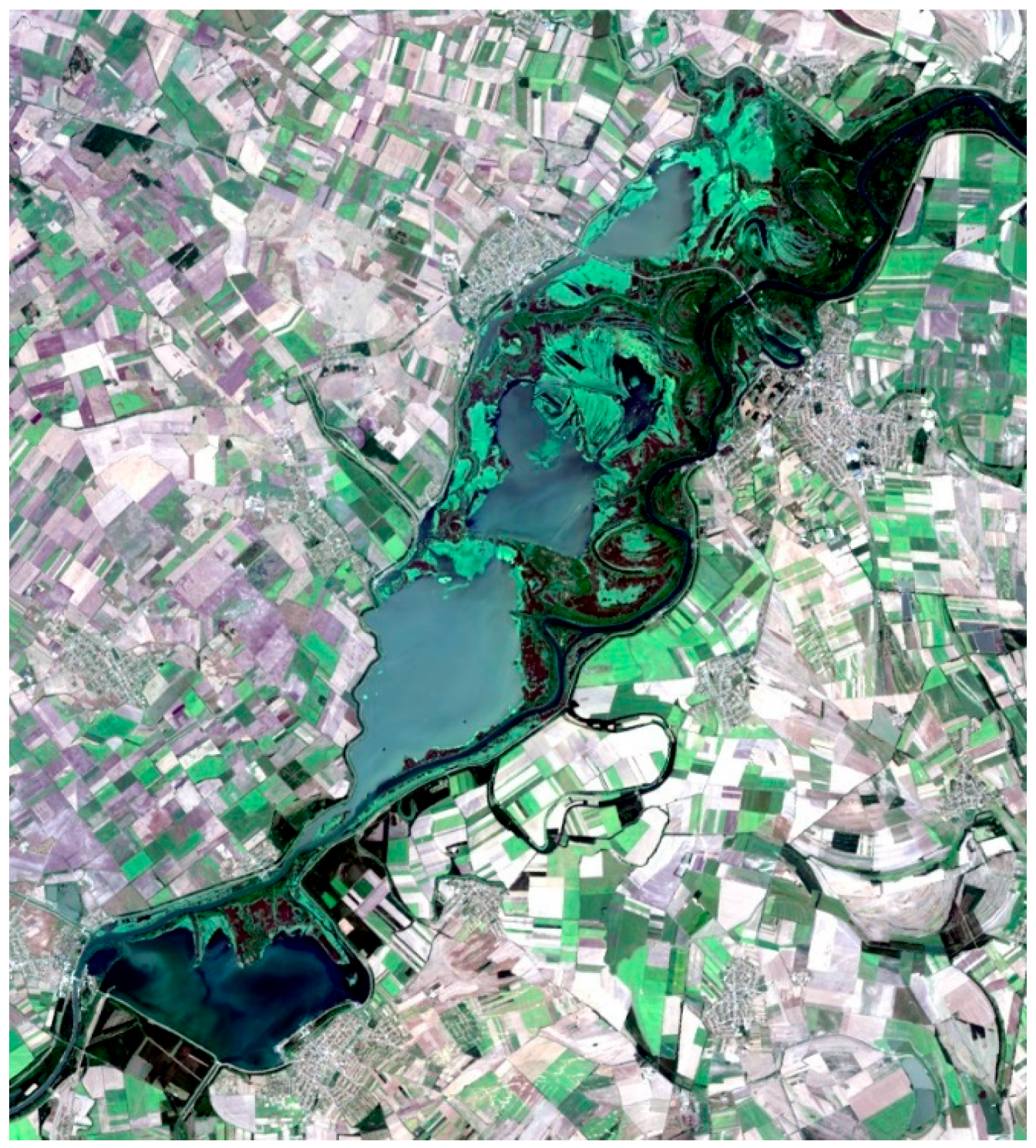
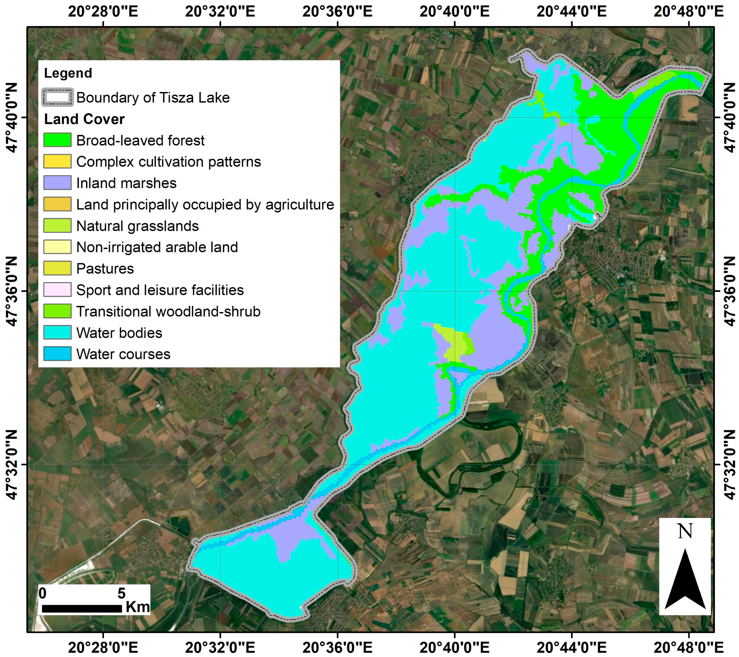
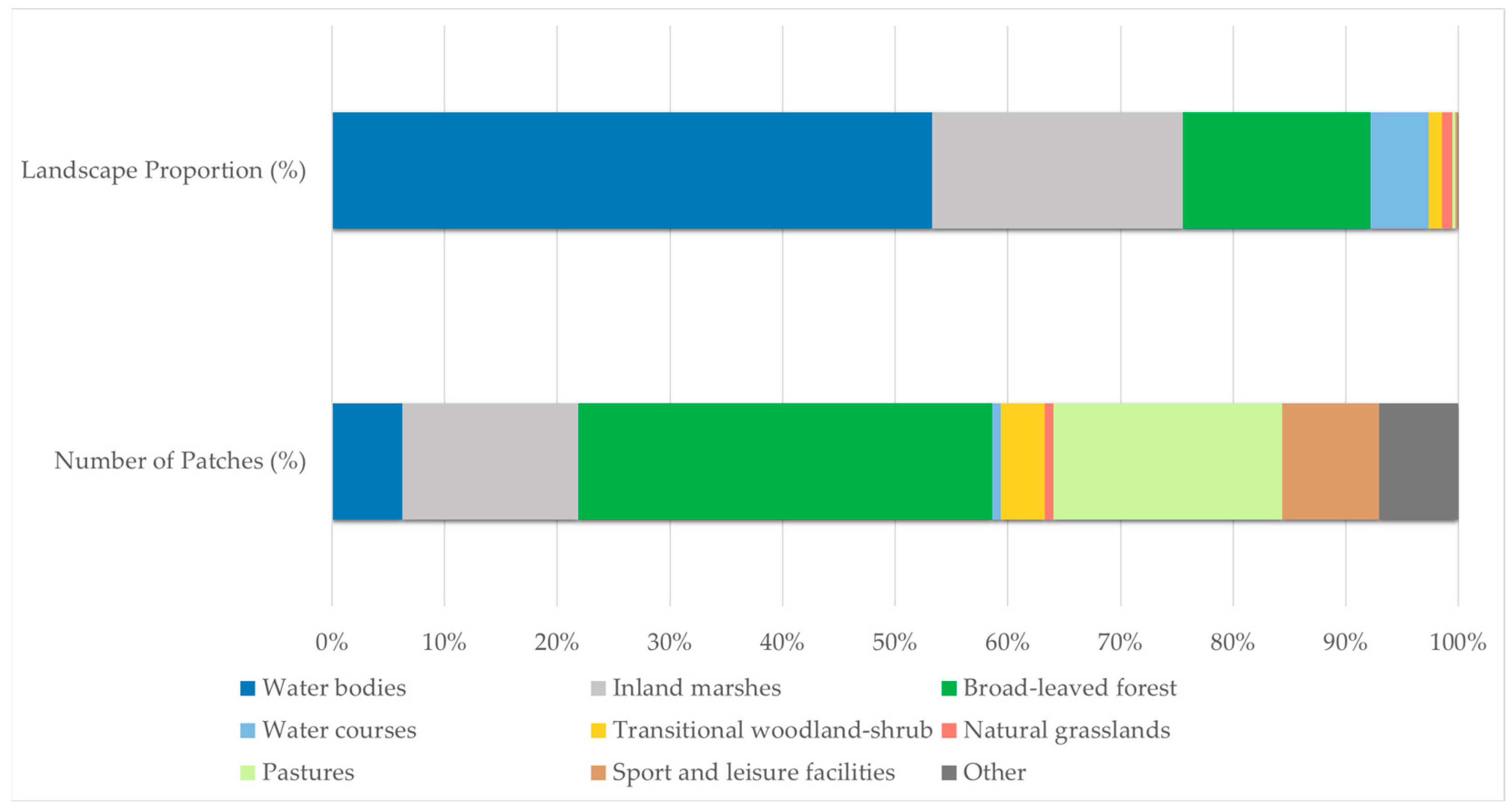
4.1. Mosaics

The results of the analysis of landscape mosaicism using GIS tools and the correlations between the field studies and the literature’s data on tourism supply are presented below.
Based on the Corine Land Cover (CLC) 2018 database, 12 different land use categories were identified in the study area, confirming the mosaic character of Lake Tisza (Figure 4). The largest proportion is represented by water bodies (53.29%), while inland marshes and broad-leaved forests cover 22.25% and 16.64%, respectively (Table 2). These three categories cover more than 90% of the total area. The combined share of agricultural land and built-up areas represents less than 1% of the total area (Table 2).
When the number of patches in each land use category is compared with the area covered by the respective category, it can be seen that the categories with the largest areas consist of relatively small patches. In the case of water bodies, the 53.29% area ratio includes only eight patches, resulting in exceptionally large patch sizes (Figure 5). In the case of broad-leaved forests and inland marshes, the relatively large proportions of the area are associated with large numbers of patches, thus contributing significantly to an increased landscape complexity. The broad-leaved forest category provides the largest number of patches (47), representing 36.7% of the total patches (Figure 5).
The heterogeneity of the area is considerably enhanced by the category pastures, which has a small area ratio but a high number of patches (26), often wedged between contiguous patches of forests (Table 2, Figure 5). These more open patches near the forests and/or surrounded by woodland are popular areas for wild camping. The category sport and leisure facilities also plays an important role in terms of tourism, with a small proportion of the total area (0.19%), but representing 8.6% of the total number of patches (Figure 5).
The largest patch sizes (max. 35.84 km2) occur along the open water areas, providing favourable conditions for water sport activities such as jet skiing, motor boating and water skiing. Since the largest water surface is located in the Abádszalók Basin, these activities are concentrated there, and hence there are no restrictions on the tourism activities. In addition, larger patch sizes are found in the categories broad-leaved forests (max 15.46 km2) and inland marshes (max 14.32 km2), which are of high conservation and ecotouristic value and are typical of basins under more stringent protection (Poroszló Basin, Tiszavalk Basin). In these basins, tourism restrictions are already applied.
According to the Shannon diversity index, representing the landscape fragmentation and landscape structure, the most complex landscape diversity can be found in the Tiszavalk (1.5) and Poroszló (1.4) Basins, considered to be the most suitable for ecotourism (Figure 6). In contrast, lower Shannon indices in the Sarud (1.1) and Abadszalók (1.1) Basins provide suitable conditions for sports and recreational tourism without further loss of landscape diversity.
The lake is a very complex ecological system: in addition to open water surfaces, wetlands overgrown with rich seaweed, bog and marsh vegetation, backwaters, oxbow lakes, steps, islands and peninsulas make the area very diverse and mosaic [68]. Equally, 42% of the open water surface is covered with seaweed and marsh vegetation, the spread of which is prevented by regular mowing of the most common aquatic plant, water caltrop (Trapa natans) (Figure 7). These interventions, however, trigger the explosive proliferation of some species (Ceratophyllum demersum, Najas marina, Urticularia vulgaris) [93]. In autumn and spring, the lake is an important stop for migratory birds, which is why the Tiszavalk sub-basin has been a Ramsar area since 1979. The reservoir is part of the National Ecological Network as a core area and its entire area has been a Natura 2000 site since 2004.
The high degree of diversity both across space and time described above has resulted in markedly different habitats and landscape mosaics. The mosaic character of Lake Tisza is enhanced by the fact that, in addition to natural differences, some conscious landscape management interventions have increased the landscape diversity. The mosaic character itself increases the landscape attractiveness of the lake, and different habitat types allow use for different tourism purposes [30,75]. This diversity of values led to Lake Tisza being the winner in the Aquatic Tourism category of the EDEN (European Destinations of Excellence) initiative in 2010 [77].
The mosaic characteristics of Lake Tisza are also confirmed by the detectable differences in the water quality data of the basins, which become more significant during the summer months. Variations in hydrochemical properties result from, among other things, the different depths of the basins, the size of the open water surface area and diverse water management practices.
The basins are filled with water from the Tisza River in April each year. Thus, the water quality of the basins does not show any significant difference in the spring. However, in the shallow basins (Table 1), significant warming of the water (26–32 °C) is observed, causing continuous separation. The highest BOI5 and CODcr values and the highest total anion content (>300 mg/L) were measured in the shallowest Tiszavalk Basin [94]. The increased values are associated with the presence of higher amounts of biomass, which decomposes faster in shallow water at high temperatures. The PO4-P content was also found to be highest in the Tiszavalk Basin. The variation in N content of the basins is related to the presence of reed beds and the aquatic plants, which can absorb significant amounts of N from the water. Due to the largest water surface area of the Abádszalók Basin, the filtering effect is less significant, causing higher N concentrations compared to the other basins. Furthermore, this basin is the most visited by tourists, so the large number of bathers may also contribute to the elevated NH4-N concentrations. However, there are no existing investigations on the impact of bathing sites on water quality; therefore, more detailed measurements should be carried out in the future.
Mosaic features could be exploited both functionally and thanks to their scenery from a touristic point of view. The following division can be observed based on the size and position of the components.

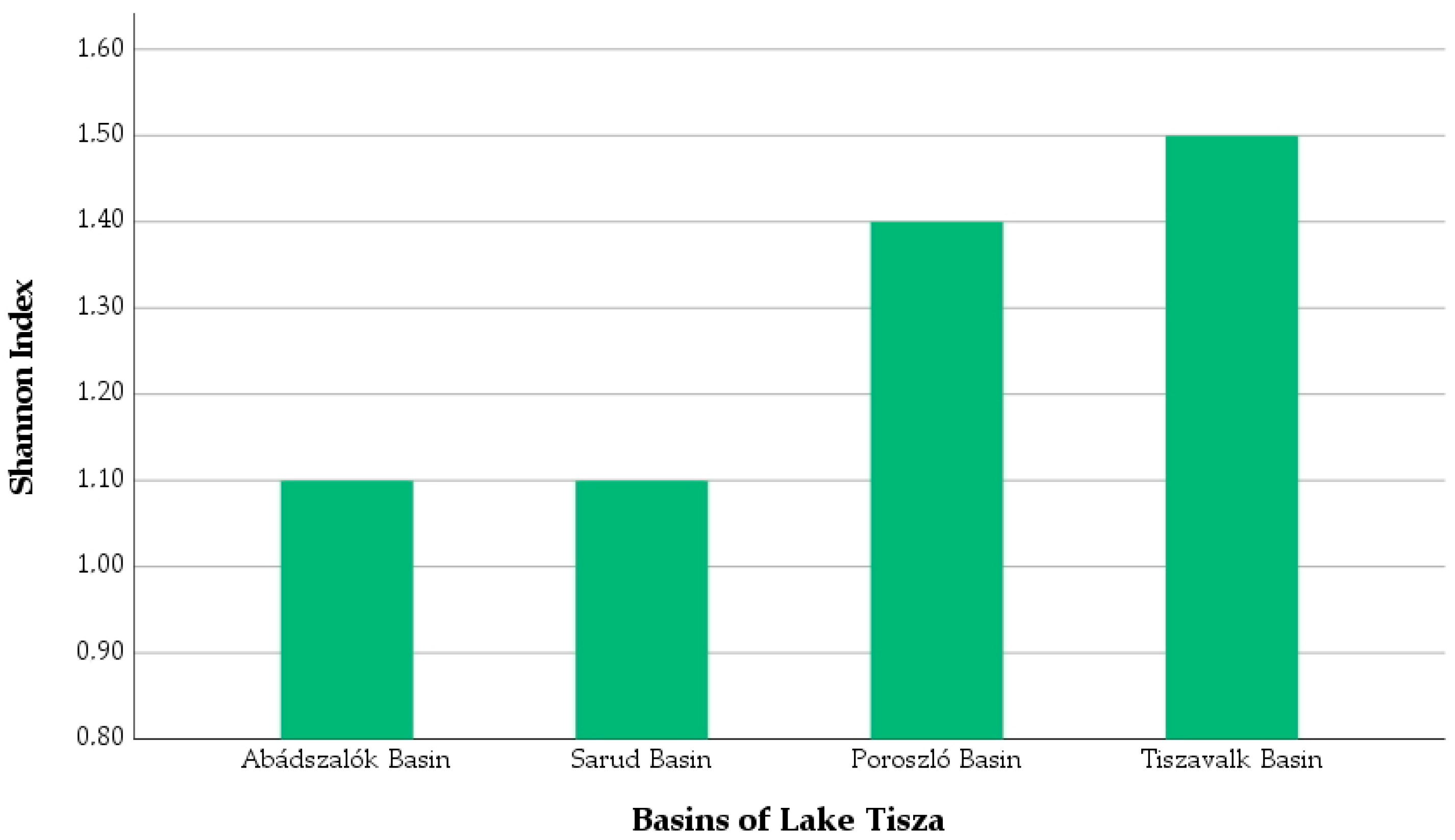
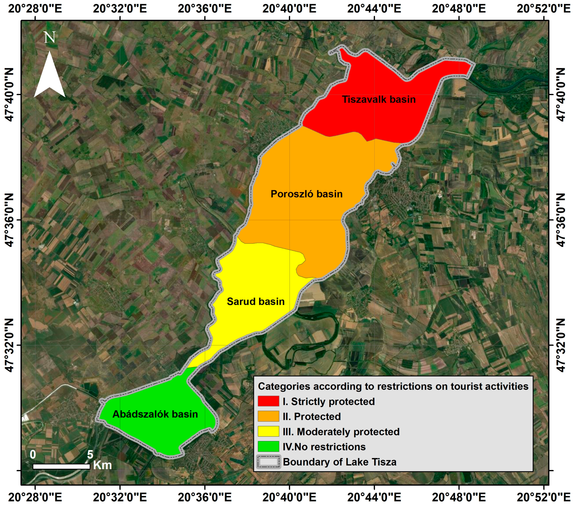
4.2. Horizontal Division

Based on the sub-basins, following the morphological and hydrological characteristics of the reservoir, the so-called zonation land use system for lake utilization was developed (Figure 8). Nature conservation regulations become softer downstream, in a NE–SW direction, determining the different touristic profile of each sub-basin and requiring different site and visitor management activities (Figure 8):
  • In the northern third of the lake (Tiszavalk Basin, category I. in Figure 8), nature protection is the primary priority. Closed and strictly closed habitats have priority over any other forms of use.
  • In certain areas of the middle section of the lake (Poroszló Basin, category II. in Figure 8), we see ecotourism, gentle water sports and fishing.
  • In the middle part of the lake (Sarud Basin, category III. in Figure 8), recreation, tourism and fishing are priority for regulation; however, nature protection also needs to be considered.
  • In the southern part of the lake (Abádszalók Basin, category IV. in Figure 8), tourism and recreation are the primary priority. The lake is used to meet the needs of “loud tourism”, water sports and entertainment, together with sport fishing. Motorised water sports equipment and sailing are equally permitted.

4.3. Vertical Division

Vertical division is rare in the case of a lowland destination; therefore, any natural or artificial object justifying such division has an increasingly important role in tourism. Linear, point-like or patch-like elements on different levels have visitor management functions in addition to their visual value [95]:
  • The level of the water is dedicated to bathers and those using watercraft (anglers, rowers, power boaters, jet-skiers, sailors, etc.). They may approach wetland habitats in permitted areas and along permitted routes but crossing vegetated areas is forbidden.
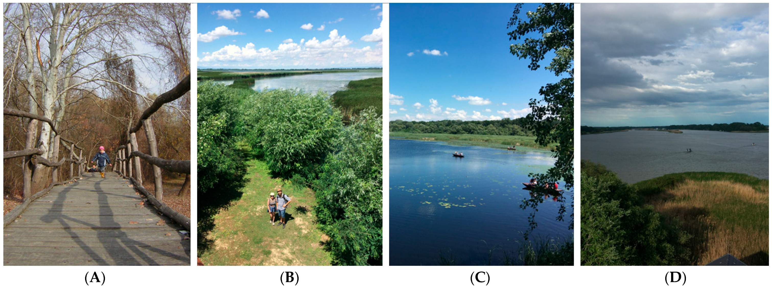
  • Plank roads can be created over wetland and marshy habitats, and also over temporarily waterlogged areas. The role of plank roads is to protect habitats, keep visitors on the route, provide views and convenient accessibility and also provide the educational function of nature trails (Figure 9).
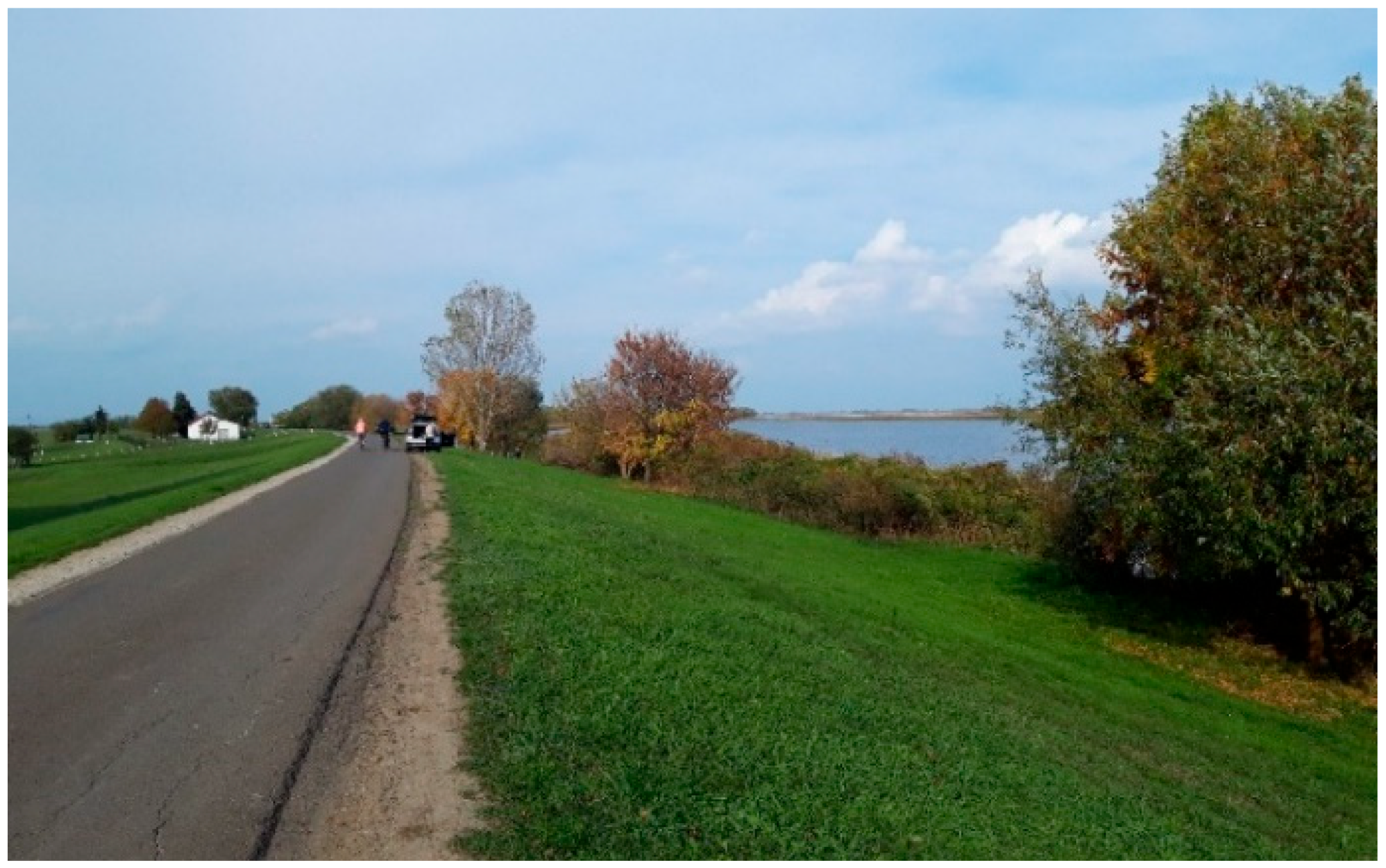
  • The embankment surrounding the lake provides a good view of the lake and of the point-like green landscape patches in the lake. The road along the embankment crown is a preferred destination for cyclists and it forms part of the cyclist route EuroVelo11 (Figure 10).
  • The free water surface, providing a feeling of spaciousness, can be viewed best from the artificial lookout towers and birdwatching towers. The 15–19 m high towers are found in the floodplain, on some islands and on the lake as well. Therefore, some of them can be accessed by bicycle, on foot or only across the water (Figure 9).

4.4. Micromosaics

Micromosaics make it possible to diversify visitor activities both across space and time. Cycling tourism, independent of water as a medium but appreciating water as a landscape element, can be observed everywhere around the lake. There are rest areas along the cycle track. The view from the embankment is usually beautiful, but in areas with more dense vegetation, lookout towers provide the view (e.g., the cycling centre in Tiszafüred) (Figure 10).
The open coastal areas (lacustrine zone) of the lake (without woody plants, shrubs and reeds) are best suited for swimming. At the same time, the shade provided by the trees is becoming more and more appreciated. For bathers, suitability is usually more important than visual attraction. The water surfaces suitable for recreation and fishing, riparian and lacustric zones, are very diverse, making it possible to enjoy different fishing methods together, almost throughout the entire year. Here again, the visual value is overridden by suitability, as has been reported in numerous publications [96,97,98]. The deeper zones more distant from the coast and also free of vegetation are places for water sports like canoeing, jet skiing, power boating and sailing. The use of the different means of waterborne transport is influenced by their suitability, in addition to the previously mentioned regulations. Vehicles powered by human power (kayaks, canoes, rowing boats) can move the most freely, and their route and destinations are primarily determined by the visual value. Blooming waterlilies (white Nymphaea alba and yellow Nuphar lutea) fields are a great attraction, but it is forbidden to travel through them. Touring the labyrinth of reed islands is the most popular activity here. There are countless opportunities for birdwatching and photography thanks to protected birds nesting, feeding or resting during migration. In this case, one might say, the sight and function (suitability) coincide.
Those who want to explore the wetlands with dry feet can also obtain information at various showrooms, with the help of floodplain trails and plank routes connecting different habitat mosaics.

5. Conclusions

Continuous adaptation to social needs and the joint protection of natural values, especially the water base, pose a major challenge for the managers of the area. The results of our research so far examining the features, outdoor recreational opportunities and existing conflicts of Lake Tisza can be summarised as follows.
Mosaics of natural habitats need to be preserved, and ecological patches of appropriate size and functional ecological corridors need to be created. At the same time, the spread of floating vegetation needs to be limited and the settling of invasive species and silting have to be impeded.
Supplying excellent water quality is important both for nature conservation goals and all recreational forms. The mosaic and zonation pattern of the recreation area on Lake Tisza contributes to this. This can also ensure that different tourism activities can coexist without conflict. The area of Lake Tisza is large enough to provide the opportunity to enjoy its original values of silence and a natural environment through differentiated use. However, while developing services that take account of this mosaic, it is essential to ensure strict compliance with the rules for the protection of natural values.
The justifiable direction of future development is to improve the infrastructure along the lake, e.g., drinking fountains for anglers and cyclists, as well as comfortable rest areas for hikers and cyclists that could be used even in winter. However, given the overcrowdedness and competition for space in certain places, constant consultation between site managers, local authorities and visitors is desirable.
Exploring the impact of various tourist activities on the environment is necessary for further landscape ecology and environmental impact studies.
In subsequent research, we will assess the extent to which landscape characteristics and mosaicism influence the choice of destinations and activities of different visitor groups (e.g., anglers, paddlers, wild campers). We will also examine the acceptance of the necessary visitor management measures, prior knowledge and environmental awareness, in order to ensure that the required restrictions are properly communicated.

Author Contributions

Conceptualization. B.B. and P.C.; methodology. B.B., P.C. and M.V.; software. D.B.; validation. T.M., E.K., I.F. and R.V.; formal analysis. B.B., P.C. and M.V.; investigation. B.B., P.C. and M.V.; resources. G.S.; data curation. P.C., B.B., M.V. and G.S.; writing—original draft preparation. B.B., P.C., T.M., G.S. and M.V.; writing—review and editing. B.B., P.C., T.M., G.S., E.K., A.R. and R.V.; visualization. B.B., P.C. and D.B.; supervision. P.C. All authors have read and agreed to the published version of the manuscript.

Funding

This research received no external funding.

Data Availability Statement

Publicly available datasets were analyzed in this study. This data can be found here: Copernicus Land Monitoring Service Corine Land Cover 2018 (raster 100 m) https://doi.org/10.2909/960998c1-1870-4e82-8051-6485205ebbac (accessed on 5 September 2023). doi link opens this page: https://sdi.eea.europa.eu/catalogue/copernicus/api/records/960998c1-1870-4e82-8051-6485205ebbac?language=all.

Acknowledgments

The authors acknowledge the assistance provided by the Middle Tisza District Water Directorate.

Conflicts of Interest

The authors declare no conflict of interest.

References

  1. Peel, D.; Lloyd, M.G. Neo-Traditional Planning. Towards a New Ethos for Land Use Planning? Land Use Policy 2007, 24, 396–403. [Google Scholar] [CrossRef]
  2. Holl, K.D.; Aide, T.M. When and Where to Actively Restore Ecosystems? For. Ecol. Manag. 2011, 261, 1558–1563. [Google Scholar] [CrossRef]
  3. Kiss, T.; Fiala, K.; Sipos, G. Alterations of Channel Parameters in Response to River Regulation Works since 1840 on the Lower Tisza River (Hungary). Geomorphology 2008, 98, 96–110. [Google Scholar] [CrossRef]
  4. Berque, A. Thinking through Landscape; Routledge: London, UK, 2020; ISBN 978-1-00-307132-7. [Google Scholar]
  5. Pinke, Z. Modernization and Decline: An Eco-Historical Perspective on Regulation of the Tisza Valley, Hungary. J. Hist. Geogr. 2014, 45, 92–105. [Google Scholar] [CrossRef]
  6. Zube, E.H.; Anderson, T.; Pitt, D. Measuring the Landscape: Perceptual Responses and Physical Dimensions. Landsc. Res. 1974, 1, 4–5. [Google Scholar] [CrossRef]
  7. Forman, R.T. Land Mosaics: The Ecology of Landscapes & Regions//Review; Wilfrid Laurier University, Geography and Environmental Studies: Waterloo, ON, Canada, 1996; Volume 24, pp. 65–70. [Google Scholar]
  8. Wu, J.; Hobbs, R.J. Key Topics in Landscape Ecology; Cambridge University Press: Cambridge, UK, 2007; ISBN 978-1-139-46214-3. [Google Scholar]
  9. Krzywinski, K.; Dannebeck, S. (Eds.) Europäische Kulturlandschaften; Aschenbeck Media: Bremen, Germany, 2009; ISBN 978-3-941624-31-3. [Google Scholar]
  10. Fadel, D. Valuation Methods of Landscape. Int. J. Res. Methodol. Soc. Sci. 2016, 2, 36–44. [Google Scholar]
  11. Bell, S. Landscape: Pattern, Perception and Process; Routledge: London, UK, 2012; ISBN 978-1-136-31890-0. [Google Scholar]
  12. McAlpine, G. Landscape Character Assessment—Guidance for England and Scotland. 2002. Available online: https://digital.nls.uk/pubs/e-monographs/2020/216649977.23.pdf (accessed on 14 October 2023).
  13. Pedroli, B.; van Doorn, A.; de Blust, G. Europe’s Living Landscapes: Essays Exploring Our Identity in the Countryside; BRILL: Shinjuku, Tokyo, 2007; ISBN 978-90-04-27807-3. [Google Scholar]
  14. Valentin, J.; Gamez, L. Environmental Psychology: New Developments; Nova Science Publishers, Inc.: New York, NY, USA, 2010; ISBN 978-1-61761-867-3. [Google Scholar]
  15. Szabó, S.; Csorba, P.; Szilassi, P. Tools for Landscape Ecological Planning—Scale, and Aggregation Sensitivity of the Contagion Type Landscape Metric Indices. Carpathian J. Earth Environ. Sci. 2012, 7, 127–136. [Google Scholar]
  16. Steg, L.; van den Berg, A.E.; de Groot, J.I.M. Environmental Psychology; John Wiley & Sons, Ltd.: Hoboken, NJ, USA, 2018; pp. 1–11. ISBN 978-1-119-24107-2. [Google Scholar]
  17. Fukarek, F.; Müller, G.; Schuster, R.; Ehricht, H.-J.; Needon, C. Pflanzenwelt der Erde; Urania: Leipzig, Germany, 1980. [Google Scholar]
  18. Ibáñez, J.J.; Zinck, J.A.; Dazzi, C. Soil Geography and Diversity of the European Biogeographical Regions. Geoderma 2013, 192, 142–153. [Google Scholar] [CrossRef]
  19. Iverson Nassauer, J. Culture and Changing Landscape Structure. Landsc. Ecol. 1995, 10, 229–237. [Google Scholar] [CrossRef]
  20. OECD. Biological Resources and Biodiversity; OECD: Paris, France, 2023. [Google Scholar]
  21. McGarigal, K.; Cushman, S.A. The Gradient Concept of Landscape Structure. In Issues and Perspectives in Landscape Ecology; Wiens, J.A., Moss, M.R., Eds.; Cambridge University Press: Cambridge, UK, 2005; pp. 112–119. ISBN 978-0-521-53754-4. [Google Scholar]
  22. Tiefenbacher, J. Perspectives on Nature Conservation: Patterns, Pressures and Prospects; BoD—Books on Demand; InTech: Rijeka, Croatia, 2012; ISBN 978-953-51-0033-1. [Google Scholar]
  23. Attila, K. Landscape protection. In Tájvédelem; Pedellus Tankönyvkiadó Kft: Debrecen, Hungary, 2007; ISBN 978-963-9612-54-9. [Google Scholar]
  24. Lausch, A.; Herzog, F. Applicability of Landscape Metrics for the Monitoring of Landscape Change: Issues of Scale, Resolution and Interpretability. Ecol. Indic. 2002, 2, 3–15. [Google Scholar] [CrossRef]
  25. Cassatella, C.; Peano, A. (Eds.) Landscape Indicators: Assessing and Monitoring Landscape Quality; Springer: Dordrecht, The Netherlands, 2011; ISBN 978-94-007-0365-0. [Google Scholar]
  26. Sowińska-Świerkosz, B.N.; Chmielewski, T.J. A New Approach to the Identification of Landscape Quality Objectives (LQOs) as a Set of Indicators. J. Environ. Manag. 2016, 184, 596–608. [Google Scholar] [CrossRef]
  27. Daniel, T.C. Whither Scenic Beauty? Visual Landscape Quality Assessment in the 21st Century. Landsc. Urban Plan. 2001, 54, 267–281. [Google Scholar] [CrossRef]
  28. Tveit, M.; Ode, Å.; Fry, G. Key Concepts in a Framework for Analysing Visual Landscape Character. Landsc. Res. 2006, 31, 229–255. [Google Scholar] [CrossRef]
  29. Konkoly-Gyuró, É.; Balázs, P.; Tirászi, Á. Transdisciplinary Approach of Transboundary Landscape Studies: A Case Study of an Austro-Hungarian Transboundary Landscape. Geogr. Tidsskr.-Dan. J. Geogr. 2019, 119, 52–68. [Google Scholar] [CrossRef]
  30. Hahn, T.; Heinrup, M.; Lindborg, R. Landscape Heterogeneity Correlates with Recreational Values: A Case Study from Swedish Agricultural Landscapes and Implications for Policy. Landsc. Res. 2018, 43, 696–707. [Google Scholar] [CrossRef]
  31. Biedenweg, K.; Williams, K.; Cerveny, L.; Styers, D. Is Recreation a Landscape Value?: Exploring Underlying Values in Landscape Values Mapping. Landsc. Urban Plan. 2019, 185, 24–27. [Google Scholar] [CrossRef]
  32. Filep, S.; Pearce, P. Tourist Experience and Fulfilment: Insights from Positive Psychology; Routledge: London, UK, 2013; ISBN 978-1-136-48207-6. [Google Scholar]
  33. Folgado-Fernández, J.A.; Di-Clemente, E.; Hernández-Mogollón, J.M.; Campón-Cerro, A.M. Water Tourism: A New Strategy for the Sustainable Management of Water-Based Ecosystems and Landscapes in Extremadura (Spain). Land 2019, 8, 2. [Google Scholar] [CrossRef]
  34. Hansen, A.S. Understanding Recreational Landscapes—A Review and Discussion. Landsc. Res. 2021, 46, 128–141. [Google Scholar] [CrossRef]
  35. Karancsi, Z.; Hornyák, S.; Szalma, E.; Oláh, F.; Korom, A.; Horváth, G.; Győri, F. Evaluating Waterfront Landscape Aesthetics as a Tourist Attraction: Case Study of the River Tisza, Hungary. Turizam 2022, 26, 105–113. [Google Scholar] [CrossRef]
  36. Wöbse, H.H. Landschaftsästhetik: Über das Wesen, die Bedeutung und den Umgang mit landschaftlicher Schönheit; Ulmer: Stuttgart, Germany, 2002; ISBN 978-3-8001-3217-1. [Google Scholar]
  37. de la Fuente de Val, G.; Atauri, J.A.; de Lucio, J.V. Relationship between Landscape Visual Attributes and Spatial Pattern Indices: A Test Study in Mediterranean-Climate Landscapes. Landsc. Urban Plan. 2006, 77, 393–407. [Google Scholar] [CrossRef]
  38. Junge, X.; Schüpbach, B.; Walter, T.; Schmid, B.; Lindemann-Matthies, P. Aesthetic Quality of Agricultural Landscape Elements in Different Seasonal Stages in Switzerland. Landsc. Urban Plan. 2015, 133, 67–77. [Google Scholar] [CrossRef]
  39. Tveit, M.S.; Ode Sang, Å.; Hagerhall, C.M. Scenic Beauty. In Environmental Psychology; John Wiley & Sons, Ltd.: Hoboken, NJ, USA, 2018; pp. 45–54. ISBN 978-1-119-24107-2. [Google Scholar]
  40. Häfner, K.; Zasada, I.; van Zanten, B.T.; Ungaro, F.; Koetse, M.; Piorr, A. Assessing Landscape Preferences: A Visual Choice Experiment in the Agricultural Region of Märkische Schweiz, Germany. Landsc. Res. 2018, 43, 846–861. [Google Scholar] [CrossRef]
  41. Todorova, A.; Asakawa, S.; Aikoh, T. Preferences for and Attitudes towards Street Flowers and Trees in Sapporo, Japan. Landsc. Urban Plan. 2004, 69, 403–416. [Google Scholar] [CrossRef]
  42. Ode, Å.; Miller, D. Analysing the Relationship between Indicators of Landscape Complexity and Preference. Environ. Plan. B Plan. Des. 2011, 38, 24–40. [Google Scholar] [CrossRef]
  43. Sowińska-Świerkosz, B. Index of Landscape Disharmony (ILDH) as a New Tool Combining the Aesthetic and Ecological Approach to Landscape Assessment. Ecol. Indic. 2016, 70, 166–180. [Google Scholar] [CrossRef]
  44. Llewellyn, D.H.; Rohse, M.; Bere, J.; Lewis, K.; Fyfe, H. Transforming Landscapes and Identities in the South Wales Valleys. Landsc. Res. 2019, 44, 804–821. [Google Scholar] [CrossRef]
  45. Arriaza, M.; Cañas-Ortega, J.F.; Cañas-Madueño, J.A.; Ruiz-Aviles, P. Assessing the Visual Quality of Rural Landscapes. Landsc. Urban Plan. 2004, 69, 115–125. [Google Scholar] [CrossRef]
  46. Soini, K.; Aakkula, J. Framing the Biodiversity of Agricultural Landscape: The Essence of Local Conceptions and Constructions. Land Use Policy 2007, 24, 311–321. [Google Scholar] [CrossRef]
  47. Wiborg, A. Place, Nature and Migration: Students’ Attachment to Their Rural Home Places. Sociol. Rural. 2004, 44, 416–432. [Google Scholar] [CrossRef]
  48. Tuohino, A. In Search of the Sense of Finnish Lakes: A Geographical Approach to Lake Tourism Marketing. Nord. Geogr. Publ. 2015, 44, 77. [Google Scholar]
  49. Hedblom, M.; Hedenås, H.; Blicharska, M.; Adler, S.; Knez, I.; Mikusiński, G.; Svensson, J.; Sandström, S.; Sandström, P.; Wardle, D.A. Landscape Perception: Linking Physical Monitoring Data to Perceived Landscape Properties. Landsc. Res. 2020, 45, 179–192. [Google Scholar] [CrossRef]
  50. Kiemstedt, H. Zur Bewertung der Landschaft für die Erholung; Ulmer: Stuttgart, Germany, 1967. [Google Scholar]
  51. Howley, P. Landscape Aesthetics: Assessing the General Publics’ Preferences towards Rural Landscapes. Ecol. Econ. 2011, 72, 161–169. [Google Scholar] [CrossRef]
  52. Tribot, A.-S.; Deter, J.; Mouquet, N. Integrating the Aesthetic Value of Landscapes and Biological Diversity. Proc. R. Soc. B Biol. Sci. 2018, 285, 20180971. [Google Scholar] [CrossRef]
  53. Zhang, Z.; Li, J.; Luo, X.; Li, C.; Zhang, L. Urban Lake Spatial Openness and Relationship with Neighboring Land Prices: Exploratory Geovisual Analytics for Essential Policy Insights. Land Use Policy 2020, 92, 104479. [Google Scholar] [CrossRef]
  54. Luttik, J. The Value of Trees, Water and Open Space as Reflected by House Prices in the Netherlands. Landsc. Urban Plan. 2000, 48, 161–167. [Google Scholar] [CrossRef]
  55. Hall, C.M.; Härkönen, T. Lake Tourism: An Integrated Approach to Lacustrine Tourism Systems; Channel View Publications: Bristol, UK, 2006; ISBN 978-1-84541-040-7. [Google Scholar]
  56. Huang, J.; Lin, H.; Qi, X. A literature review on optimization of spatial development pattern based on ecological-production-living space. Prog. Geogr. 2017, 36, 378–391. [Google Scholar] [CrossRef]
  57. Furgała-Selezniow, G.; Jankun-Woźnicka, M.; Mika, M. Lake Regions under Human Pressure in the Context of Socio-Economic Transition in Central-Eastern Europe: The Case Study of Olsztyn Lakeland, Poland. Land Use Policy 2020, 90, 104350. [Google Scholar] [CrossRef]
  58. Newsome, D.; Moore, S.A.; Dowling, R.K. Natural Area Tourism: Ecology, Impacts and Management. In Natural Area Tourism; Channel View Publications: Bristol, UK, 2012; ISBN 978-1-84541-383-5. [Google Scholar]
  59. Geneletti, D.; van Duren, I. Protected Area Zoning for Conservation and Use: A Combination of Spatial Multicriteria and Multiobjective Evaluation. Landsc. Urban Plan. 2008, 85, 97–110. [Google Scholar] [CrossRef]
  60. Hjortsø, C.N.; Stræde, S.; Helles, F. Applying Multi-Criteria Decision-Making to Protected Areas and Buffer Zone Management: A Case Study in the Royal Chitwan National Park, Nepal. J. For. Econ. 2006, 12, 91–108. [Google Scholar] [CrossRef]
  61. Zhao, Y.; Huang, X.; Zhao, Y.; Liu, X.; Zhou, R. The Application of Landscape Character Classification for Spatial Zoning Management in Mountainous Protected Areas—A Case Study of Laoshan National Park, China. Heliyon 2023, 9, e13996. [Google Scholar] [CrossRef]
  62. Bentz, J.; Lopes, F.; Calado, H.; Dearden, P. Sustaining Marine Wildlife Tourism through Linking Limits of Acceptable Change and Zoning in the Wildlife Tourism Model. Mar. Policy 2016, 68, 100–107. [Google Scholar] [CrossRef]
  63. Meyerhoff, J.; Klefoth, T.; Arlinghaus, R. The Value Artificial Lake Ecosystems Provide to Recreational Anglers: Implications for Management of Biodiversity and Outdoor Recreation. J. Environ. Manag. 2019, 252, 109580. [Google Scholar] [CrossRef]
  64. Hungarian Central Statistical Office. A Kereskedelmi Szálláshelyek Vendégforgalma Turisztikai Régiónként. Available online: https://www.ksh.hu/stadat_files/tur/hu/tur0021.html (accessed on 26 October 2023).
  65. Hungarian Central Statistical Office. Irrigation in Hungary. Available online: https://www.ksh.hu/stadat_files/mez/hu/mez0094.html (accessed on 26 October 2023).
  66. Szabó, L.; Deák, B.; Bíró, T.; Dyke, G.J.; Szabó, S. NDVI as a Proxy for Estimating Sedimentation and Vegetation Spread in Artificial Lakes—Monitoring of Spatial and Temporal Changes by Using Satellite Images Overarching Three Decades. Remote Sens. 2020, 12, 1468. [Google Scholar] [CrossRef]
  67. Lőrinc, F. The Water System of the Lake Tisza. A Tisza-Tó Vízrendszere. Available online: http://www.kotikovizig.hu/index.php?option=com_content&view=article&id=20:tisza-to-vizrendszere&catid=47:tisza-to-vizrendszere&Itemid=77 (accessed on 27 October 2023).
  68. Mariann, T.N.; Lőrinc, F. (Eds.) 40 Years of Lake Tisza. 40 éves a Tisza-Tó; Middle-Tisza District Water Directorate: Szolnok, Hungary, 2018; ISBN 978-615-00-1647-4. [Google Scholar]
  69. Venohr, M.; Langhans, S.D.; Peters, O.; Hölker, F.; Arlinghaus, R.; Mitchell, L.; Wolter, C. The Underestimated Dynamics and Impacts of Water-Based Recreational Activities on Freshwater Ecosystems. Environ. Rev. 2018, 26, 199–213. [Google Scholar] [CrossRef]
  70. Grizzetti, B.; Liquete, C.; Pistocchi, A.; Vigiak, O.; Zulian, G.; Bouraoui, F.; De Roo, A.; Cardoso, A.C. Relationship between Ecological Condition and Ecosystem Services in European Rivers, Lakes and Coastal Waters. Sci. Total Environ. 2019, 671, 452–465. [Google Scholar] [CrossRef]
  71. Serbov, M.H. Scientific Basis for the Development of Recreational Fishing in the Reservoirs of Ukraine. Vodn. Bioresursy Ta Akvakult. 2012, 2, 49–64. [Google Scholar]
  72. Pokki, H.; Pellikka, J.; Eskelinen, P.; Moilanen, P. Regional Fishing Site Preferences of Subgroups of Finnish Recreational Fishers. Scand. J. Hosp. Tour. 2021, 21, 442–457. [Google Scholar] [CrossRef]
  73. Nikolaus, R.; Matern, S.; Schafft, M.; Maday, A.; Wolter, C.; Klefoth, T.; Arlinghaus, R. Influence of Protected Riparian Areas on Habitat Structure and Biodiversity in and at Small Lakes Managed by Recreational Fisheries. Fish. Res. 2022, 256, 106476. [Google Scholar] [CrossRef]
  74. Acreman, M.; Hughes, K.A.; Arthington, A.H.; Tickner, D.; Dueñas, M.-A. Protected Areas and Freshwater Biodiversity: A Novel Systematic Review Distils Eight Lessons for Effective Conservation. Conserv. Lett. 2020, 13, e12684. [Google Scholar] [CrossRef]
  75. Meyer, N.; Schafft, M.; Wegner, B.; Wolter, C.; Arlinghaus, R.; Venohr, M.; von Oheimb, G. A Day on the Shore: Ecological Impacts of Non-Motorised Recreational Activities in and around Inland Water Bodies. J. Nat. Conserv. 2021, 64, 126073. [Google Scholar] [CrossRef]
  76. Új Biciklis Forgalmi Csúcs Kiskörén. Available online: http://www.kotivizig.hu/kozep-tisza-videki/hireink/sajtohirek/uj-biciklis-forgalmi-csucs-kiskoren (accessed on 13 November 2023).
  77. Kovács, J. Idén Is Óriásit Lép Előre a Tisza-Tó és Térsége. Available online: https://ilovetiszato.hu/2021/04/06/iden-is-oriasit-lep-elore-a-tisza-to-es-tersege/ (accessed on 26 October 2023).
  78. Bonnichsen, O.; Jensen, C.L.; Olsen, S.B. An Empirical Investigation of German Tourist Anglers’ Preferences for Angling in Denmark; IFRO Working Paper; University of Copenhagen, Department of Food and Resource Economics: Copenhagen, Denmark, 2016. [Google Scholar]
  79. Arlinghaus, R.; Alós, J.; Beardmore, B.; Daedlow, K.; Dorow, M.; Fujitani, M.; Hühn, D.; Haider, W.; Hunt, L.M.; Johnson, B.M.; et al. Understanding and Managing Freshwater Recreational Fisheries as Complex Adaptive Social-Ecological Systems. Rev. Fish. Sci. Aquac. 2017, 25, 1–41. [Google Scholar] [CrossRef]
  80. Cooke, S.J.; Arlinghaus, R.; Johnson, B.M.; Cowx, I.G. Recreational Fisheries in Inland Waters. In Freshwater Fisheries Ecology; John Wiley & Sons, Ltd.: Hoboken, NJ, USA, 2015; pp. 449–465. ISBN 978-1-118-39438-0. [Google Scholar]
  81. Brownscombe, J.W.; Hyder, K.; Potts, W.; Wilson, K.L.; Pope, K.L.; Danylchuk, A.J.; Cooke, S.J.; Clarke, A.; Arlinghaus, R.; Post, J.R. The Future of Recreational Fisheries: Advances in Science, Monitoring, Management, and Practice. Fish. Res. 2019, 211, 247–255. [Google Scholar] [CrossRef]
  82. Beardmore, B.; Hunt, L.M.; Haider, W.; Dorow, M.; Arlinghaus, R. Effectively Managing Angler Satisfaction in Recreational Fisheries Requires Understanding the Fish Species and the Anglers. Can. J. Fish. Aquat. Sci. 2015, 72, 500–513. [Google Scholar] [CrossRef]
  83. Benkhard, B. Travel Practice of the New Generation of Tourist Managers in the University of Debrecen. In Book of Proceedings Vol. II—International Conference on Tourism & Management Studies—Algarve 2011; 2012; pp. 1011–1013. Available online: https://www.tmstudies.net/index.php/ectms/issue/view/10 (accessed on 16 October 2023).
  84. Vasvári, M.; Boda, J.; Dávid, L.; Bujdosó, Z. Water-Based Tourism as Reflected in Visitors to Hungary’s Lakes. Geoj. Tour. Geosites 2015, 15, 91–103. [Google Scholar]
  85. Dávid, L.D.; Kóródi, M.; Puczko, L.; Vasvári, M. A Tisza-Tó Imázsa És Márkázottsága. Tur. Bull. 2010, 2010, 85–92. [Google Scholar]
  86. Gallardo, M.; Cocero, D. Using the European CORINE Land Cover Database: A 2011–2021 Specific Review. In Sustainable Development Goals in Europe: A Geographical Approach; De Lázaro Torres, M.L., De Miguel González, R., Eds.; Key Challenges in Geography; Springer International Publishing: Berlin/Heidelberg, Germany, 2023; pp. 303–325. ISBN 978-3-031-21614-5. [Google Scholar]
  87. Büttner, G. CORINE Land Cover and Land Cover Change Products. In Land Use and Land Cover Mapping in Europe: Practices & Trends; Manakos, I., Braun, M., Eds.; Remote Sensing and Digital Image Processing; Springer: Dordrecht, The Netherlands, 2014; pp. 55–74. ISBN 978-94-007-7969-3. [Google Scholar]
  88. Aune-Lundberg, L.; Strand, G.-H. The Content and Accuracy of the CORINE Land Cover Dataset for Norway. Int. J. Appl. Earth Obs. Geoinf. 2021, 96, 102266. [Google Scholar] [CrossRef]
  89. Jung, M. LecoS—Landscape Ecology Statistics. Available online: https://plugins.qgis.org/plugins/LecoS/ (accessed on 23 September 2023).
  90. Bueno, A.S.; Peres, C.A. Patch-Scale Biodiversity Retention in Fragmented Landscapes: Reconciling the Habitat Amount Hypothesis with the Island Biogeography Theory. J. Biogeogr. 2019, 46, 621–632. [Google Scholar] [CrossRef]
  91. Sardar, P.; Samadder, S.R. Understanding the Dynamics of Landscape of Greater Sundarban Area Using Multi-Layer Perceptron Markov Chain and Landscape Statistics Approach. Ecol. Indic. 2021, 121, 106914. [Google Scholar] [CrossRef]
  92. Dušek, R.; Popelková, R. Theoretical View of the Shannon Index in the Evaluation of Landscape Diversity. Auc Geogr. 2017, 47, 5–13. [Google Scholar] [CrossRef]
  93. EDEN. 2023 EDEN—European Destinations of Excellence. Available online: https://single-market-economy.ec.europa.eu/sectors/tourism/awards-and-outreach-activities/eden_en (accessed on 26 October 2023).
  94. Mester, T.; Benkhard, B.; Vasvári, M.; Csorba, P.; Kiss, E.; Balla, D.; Fazekas, I.; Csépes, E.; Barkat, A.; Szabó, G. Hydrochemical Assessment of the Kisköre Reservoir (Lake Tisza) and the Impacts of Water Quality on Tourism Development. Water 2023, 15, 1514. [Google Scholar] [CrossRef]
  95. Eagles, P.F.J.; McCool, S.F.; Haynes, C.D. Sustainable Tourism in Protected Areas: Guidelines for Planning and Management; IUCN: Gland, Switzerland, 2002; ISBN 978-2-8317-0648-1. [Google Scholar]
  96. Dabrowksa, K.; Hunt, L.M.; Haider, W. Understanding How Angler Characteristics and Context Influence Angler Preferences for Fishing Sites. N. Am. J. Fish. Manag. 2017, 37, 1350–1361. [Google Scholar] [CrossRef]
  97. Matsumura, S.; Beardmore, B.; Haider, W.; Dieckmann, U.; Arlinghaus, R. Ecological, Angler, and Spatial Heterogeneity Drive Social and Ecological Outcomes in an Integrated Landscape Model of Freshwater Recreational Fisheries. Rev. Fish. Sci. Aquac. 2019, 27, 170–197. [Google Scholar] [CrossRef]
  98. Deely, J.; Hynes, S.; Curtis, J. Coarse Angler Site Choice Model with Perceived Site Attributes. J. Outdoor Recreat. Tour. 2020, 32, 100177. [Google Scholar] [CrossRef]
Figure 1. Location and sub-basins of Lake Tisza. Source of base map: Esri, Maxar, Earthstar Geographics, and the GIS User Community.
Land 12 02092 g001
Figure 2. Change in the central part of Lake Tisza (Poroszló Basin) from the 18th century to nowadays. (A): Europe in the 18th century, (B): Kingdom of Hungary 1819–1869 (second military survey), (C): military survey, 1941, (D): 1st March 2023 (Source: (AC): mapire.eu, (D): OpenStreetMap).
Land 12 02092 g002
Figure 3. Lake Tisza area, Hungary, on OLI’s true colour composite, showing the close-to-natural and mosaic character of the northern part and the increasing open water surfaces towards the south. Source: Landsat-8 [66]. Earth Explorer, image courtesy of the U.S. Geological Survey.
Land 12 02092 g003
Figure 4. Land cover categories of Lake Tisza, based on CORINE CLC2018. Source of base map: Esri, Maxar, Earthstar Geographics, and the GIS User Community.
Land 12 02092 g004
Figure 5. Proportion of the land cover categories and the number of patches for Lake Tisza.
Land 12 02092 g005
Figure 6. Shannon diversity index values of the basins of Lake Tisza.
Land 12 02092 g006
Figure 7. Continuously vegetated water surface in the Poroszló sub-basin with some strips cleared from water caltrop (September 2022). Source: Own photo (Csorba).
Land 12 02092 g007
Figure 8. Zonation of Lake Tisza according to restrictions on tourist activities. Source of base map: Esri, Maxar, Earthstar Geographics, and the GIS User Community.
Land 12 02092 g008
Figure 9. (A) Plank road along the nature trail on the floodplain of the reservoir, (B) view of the reservoir from a lookout tower on a former river levee, (C) view of Göbe (a lake formed on an island on the floodplain), (D) view of Small Tisza at Poroszló from the 19 m high lookout tower at the port of Kisköre. Source: Own photos (Benkhard).
Land 12 02092 g009
Figure 10. Embankment around the lake (October 2022). Source: Own photo (Csorba).
Land 12 02092 g010
Table 1. Data characterising the different parts of Lake Tisza. Source: Middle Tisza District Water Directorate [68].
Area km2Average Water Depth cmProportion of Open Water Surface %Proportion of the Lake Temporarily Covered by Aquatic Vegetation %
Tiszavalk part2650–604456
Poroszló part52804555
Sarud part281207624
Abádszalók part212108317
Table 2. Calculated landscape metric parameters based on the categories of the CORINE CLC2018 land cover database.
Landscape MetricsLand Cover Categories
Sport and Leisure FacilitiesNon-Irrigated Arable LandPasturesBroad-Leaved ForestNatural GrasslandsTransitional Woodland ShrubInland MarshesWater CoursesWater Bodies
Land cover (km2)0.0100.2400.0400.3900.0100.04021.3901.1801.460
Landscape Proportion (%)0.01%0.19%0.03%0.30%0.01%0.03%16.64%0.92%1.14%
Number of Patches 111326144715
Greatest patch area (km2)0.010.040.020.040.010.0115.461.180.65
Smallest patch area (km2)0.010.010.010.010.010.010.011.180.01
Mean patch area (km2)0.010.020.010.020.010.010.461.180.29
Median patch area (km2)0.010.020.010.010.010.010.011.180.28
Disclaimer/Publisher’s Note: The statements, opinions and data contained in all publications are solely those of the individual author(s) and contributor(s) and not of MDPI and/or the editor(s). MDPI and/or the editor(s) disclaim responsibility for any injury to people or property resulting from any ideas, methods, instructions or products referred to in the content.

