Abstract
Ecotourism, a dynamic force in global tourism, holds promise for conserving the environment while ensuring benefits for local economies. In this study, we developed an ecotourism distribution map of Indonesia. We utilized location-based social networks (LSBNs) data derived from Google Maps API to map 172 ecotourism sites in Indonesia. Furthermore, we investigated the distribution patterns of ecotourism within Indonesia’s protected landscapes and ecoregions. The factors that influenced ecotourism distribution in the region were analyzed using the MaxEnt model (because of its application for presence-only data). The key findings revealed that ecotourism sites are predominantly distributed across national parks and protected forest areas, and generally consist of mountainous and hilly terrain according to the ecoregion types. The MaxEnt model results indicated that population density was the most influential factor in ecotourism distribution. The significance of our study lies in its methodologies and results, which offered novel approaches to nationwide mapping and addressed the lack of an ecotourism site map of Indonesia. Notably, the proposed model can be customized for other regions with limited ecotourism data; thus, our study can serve as a foundation for future interdisciplinary studies on ecotourism, sustainability, and landscape planning.
1. Introduction
Ecotourism is an emerging sector in the tourism industry that aims to conserve natural and cultural resources while also providing economic benefits to local communities.. Ecotourism can contribute to biodiversity conservation by providing financial incentives to local communities to protect their natural resources [1,2]. In addition, ecotourism can help preserve cultural heritage by promoting ecological wisdom and providing economic support to local communities to maintain traditional practices [3,4].
The most important aspect of ecotourism is its potential to benefit local communities economically. Ecotourism has the potential to boost income and create employment opportunities for local communities in Indonesia, especially for those residing in rural and remote regions [5,6]. Furthermore, ecotourism can also contribute to the development of local economies by promoting small businesses and providing opportunities for local entrepreneurs [7]. Many local communities are eager to develop ecotourism sites to create economic flow but lack commitment to genuine ecotourism, often using the term as a marketing ploy rather than focusing on intended sustainable development and management concepts. [8].
Previous studies have highlighted the negative impacts of ecotourism on the environment, economy, and society, such as overcrowding and degradation of natural and cultural resources when not properly managed [1,2,8]. Additionally, if not managed effectively, ecotourism can lead to the displacement of local communities and erosion of traditional cultures [9]. Considering these potentially positive and negative impacts, it is important to understand the characteristics and distribution of ecotourism in the context of the region.
Indonesia is witnessing rapid ecotourism growth, with significant progress being noted over the last two decades [10]. However, a comprehensive understanding of the existing ecotourism sites and their distribution across Indonesia is yet to be achieved; notably, this information is crucial for effectively managing and promoting different industries in the region. Unfortunately, despite the growing interest in ecotourism, a nationwide map of the ecotourism sites in Indonesia is currently unavailable. The lack of primary baseline data presents a significant challenge for scholars and practitioners when improving regional ecotourism practices. Therefore, it is essential to conduct studies that can address the knowledge gap in the current literature and data and provide a comprehensive understanding of ecotourism in Indonesia.
To pursue a proper study of ecotourism in Indonesia, it is necessary to have a complete list of the existing ecotourism sites within the country, accessible to tourists, researchers, planners, and even the communities. In addition, the absence of a national ecotourism site distribution map poses several challenges. For example, the lack of fundamental baseline data makes it challenging to elevate Indonesia’s ecotourism industry through research.
This situation is unsurprising because Indonesia’s national spatial data system has encountered challenges since the beginning of its implementation three decades ago [11]. Even the government’s One Map Policy mapping program has not successfully resolved the issues [12]. Several scholars attempted to provide affordable and convenient geographic information system (GIS) methods for mapping, e.g., mapping health facilities [13] and villages [14] in Indonesia. With respect to mapping at the national scale, significant obstacles pertaining to limited technical resources, financial support, and labor have been noted [15]. Introducing a novel methodological approach for national-scale mapping can contribute significantly to the field of spatial-mapping studied in Indonesia.
In this study, we addressed a notable gap in the literature by developing a comprehensive nationwide ecotourism map of Indonesia and introducing an innovative approach for enabling mapping on the national scale. To achieve these objectives, we focused on the following goals:
- Develop a map of ecotourism sites for Indonesia using the data from location-based social networks (LBSNs)
- Investigate the relationships between the distribution of ecotourism sites within the country’s protected landscapes and ecoregions
- Explore the influencing factors that contribute to the variations in ecotourism distribution across Indonesia
2. Literature Review
2.1. Roots of Ecotourism in Indonesia
In the 1980s, Indonesia’s tourism industry flourished concurrently with the implementation of a national park policy for the protection of the Komodo dragon within the Komodo National Park. This legislative initiative aimed to balance tourism growth with environmental preservation [16]. Indonesian ecotourism promotes tourism in protected landscapes, specifically the Komodo National Park. It is a proactive measure that aligns the country’s economic interests with its environmental awareness.
Despite the environmental initiatives implemented in the 1990s, a substantial upswing in ecotourism in Indonesia occurred only in the past two decades. With respect to academia, there has been a transition from niche to mainstream study topics, indicating a rising preference for environmentally conscious travel experiences offered by Indonesia’s rich biodiversity [10].
The ecotourism in Indonesia entails the integration of different forms of tourism, presenting challenges with respect to analyzing the impact of ecotourism from those of alternative tourism forms. Notably, genuine ecotourism is often perceived as less profitable than mass ecotourism. However, there is no evidence to date that overlooking the genuine ecotourism concept could deliver the initially promised benefits for marginalized communities and biodiversity conservation [17]. Therefore, in this study, the definition of “genuine ecotourism” is chosen over that of a wider spectrum of ecotourism, or even mass ecotourism, for selecting ecotourism sites in Indonesia. This choice entails defining ecotourism as an alternative form of tourism within protected landscapes, with minimal environmental impact and significant benefits for local communities.
2.2. Protected Landscape in Indonesia
In this study, in line with “genuine ecotourism”, we established an inherent association with the protected landscapes in Indonesia. This connection arose from the stipulation that any form of tourism within a protected landscape must adhere to ecotourism principles. This requirement ensures that all tourism activities in ecologically sensitive areas are characterized by a commitment to sustainability and responsible practices. In Indonesia, protected landscapes are regulated within the forest estate, categorized based on their function, namely conservation forests, protected forests, and production forests. Within conservation forests and protected forests, ecotourism is the only type of tourism permitted [18]. Figure 1 presents the maps of the protected areas in Indonesia by function.
Social forestry, a community-based forest management (CBFM) scheme within the protected landscape of Indonesia, should also be considered in the discussions on ecotourism in Indonesia. The social forestry initiative in Indonesia commenced in the 1990s, with a significant increase over the last 15 years (in line with the government targets) [19,20]. A crucial aspect of social forestry involves the utilization of non-timber forest products by local communities in protected landscape areas; ecotourism is promoted as an activity within this scheme.
2.3. Location-Based Social Networks (LSBNs)
In recent years, the integration of location-based social network (LSBN) data into various study domains has gained significant traction. Our study focused on leveraging LSBN data to gain insights into ecotourism sites nationwide, with a specific emphasis on Indonesia. Scholars have increasingly recognized social media as a valuable resource for advancing novel investigations in diverse fields, including land use, urban activities, human behavior, and landscape planning [21,22,23].
The use of LSBN data, particularly Google Maps API, offers a unique opportunity to map ecotourism sites efficiently and effectively at a low cost. Several studies have demonstrated the usefulness of LSBNs, such as Foursquare, Twitter, Google Maps API, Instagram, and Airbnb, in geospatial studies. In this study, we utilized Google Maps API.
For this study, we selected Google Maps API as the primary data source because of its specific considerations. One of the critical considerations for selecting Google Maps API was its focus on retrieving geographic locations. Even though LSBNs may provide more detailed data, e.g., pictures and user perceptions, Google Maps API offers a balance by providing essential location information. Additionally, Google Maps API is often registered by users who are typically owners or managers of places, ensuring the credibility of the data [24].
Furthermore, the categorization features of Google Maps API are crucial for distinguishing ecotourism sites from other places that use similar keywords. This categorization allows for the efficient elimination of irrelevant entries, thereby enhancing the accuracy of the collected data. For instance, the categorization feature can help filter out entries such as “Faculty of Ecotourism” by classifying them under the “Education” category.
Another notable factor is Google’s widespread use in Indonesia. Google, the most commonly used search engine, is accessible to a broad user base and does not require special skills or training. This accessibility ensures a larger pool of contributors to the LSBN dataset, contributing to a comprehensive and representative dataset for ecotourism mapping. However, it is important to note that the data obtained from the Google Maps API to identify ecotourism sites across Indonesia is user-generated data. Therefore, this approach is subject to certain limitations, especially in areas where user-generated data is limited or unavailable.
2.4. Ecoregions of Indonesia
In this study, the landscape types in Indonesia were represented by classifying the ecoregion types (see Figure 1). Ecoregions, defined as geographical areas that share similarities in various environmental aspects, are focal points in ecological and environmental studies. The understanding of Indonesian ecoregions is coded in SK.8/MNLHK/2018, which comprehensively outlines the defining characteristics of these regions. These characteristics encompass a range of factors, including natural landscape features, river basins, climate, flora and fauna, sociocultural aspects, economy, community institutions, and environmental inventory results.
Figure 1.
(a) Protected landscape of Indonesia based on forest state by function, and (b) ecoregion types of Indonesia (Source: geospatial information system of The Ministry of Environment and Forestry Indonesia [25]).
The definition of “ecoregions” under Law No. 32 2009 reflects a holistic perspective beyond mere ecological considerations. By encompassing the sociocultural and economic aspects, the law recognizes the intricate interplay between the human society and natural environment. This comprehensive approach aligns with contemporary ecological thinking, which emphasizes the correlations between ecological, social, and economic systems.
The ecoregions used in this study were established by the Ministry of Environment and Forestry of Indonesia. These ecoregions are categorized based on landform classifications determined by their morphology, including plains, hills, and mountains, as well as their morphogenesis, such as fluvial, karst, structural, volcanic, organic, and glacial formations. In this context, ‘structural’ refers to landforms shaped by geological processes related to the deformation of the Earth’s crust, such as folding or faulting. Plains, hills and mountains, on the other hand, were classified based on their elevation and slopes [26].
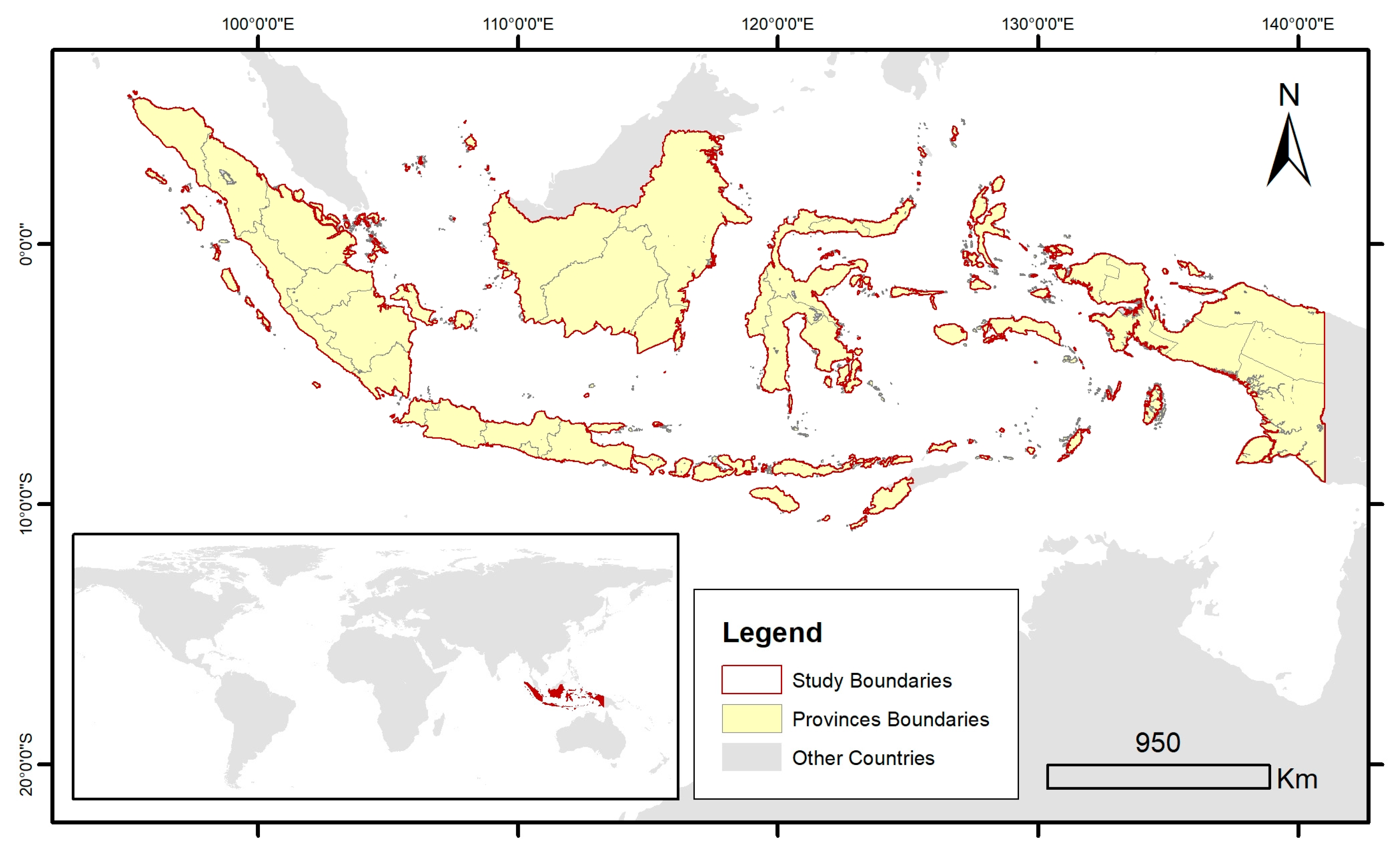
3. Study Area, Data, and Methodology
Our study area encompassed the entire extent of Indonesia, spanning a vast spatial extent of the country (Figure 2). Situated in Southeast Asia, Indonesia is an archipelago positioned between the longitude 95°–141° E and latitude of 6° N–11° S, straddling the equator. Indonesia comprises approximately 13,466 islands, covering a total land area of 1,895,257.5 km2 [27].
Figure 2.
Map of Indonesia as Study Area.
The spatial reference used for this study was the WGS 1984 World Mercator projection. All analyses were conducted based on standardized spatial references. To enhance visualization, the units were converted to international standards. The study process was divided into two main parts (see Figure 3).
Figure 3.
Flowchart portraying the study process and methodology.
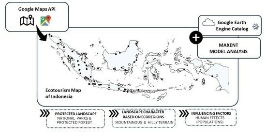
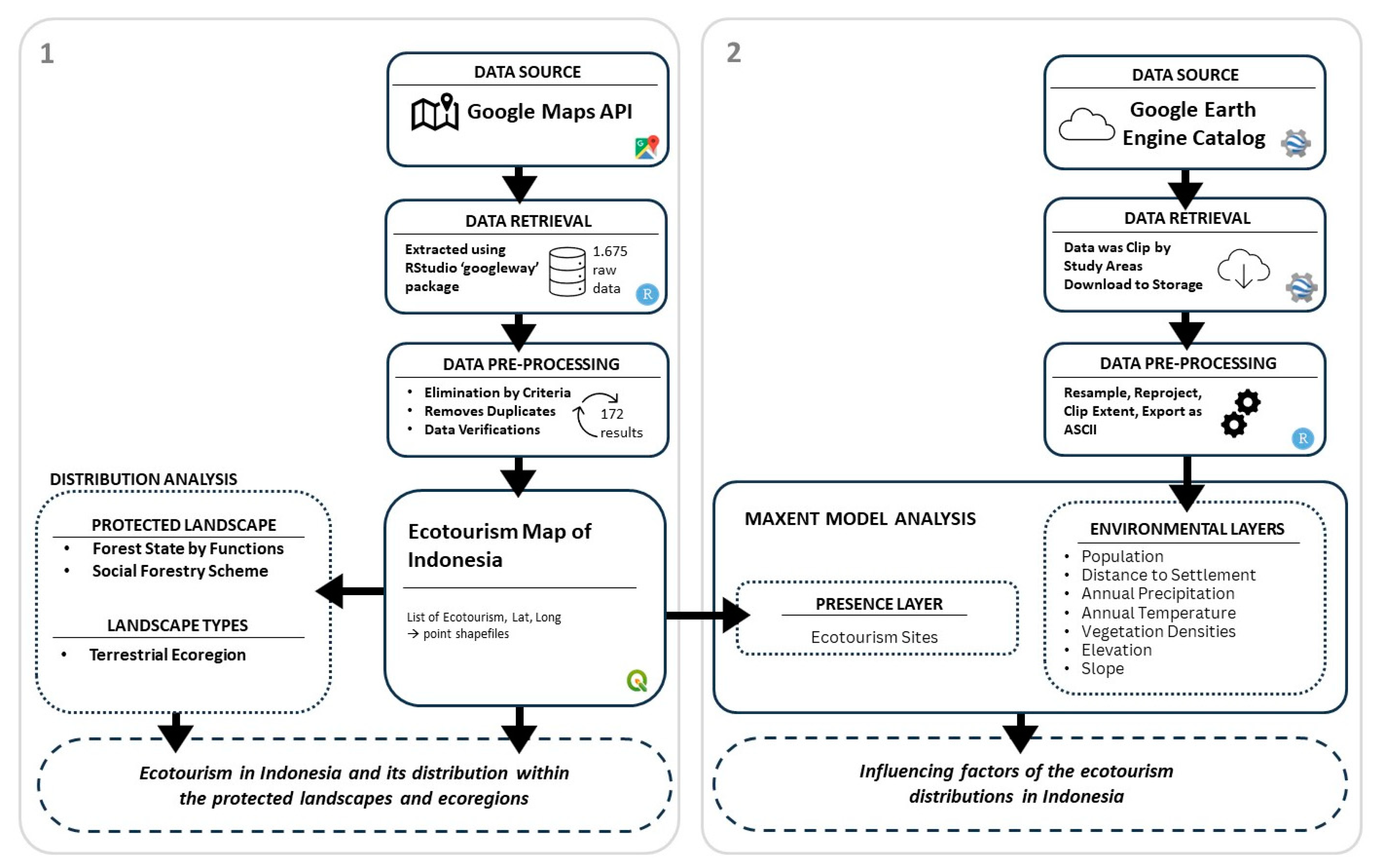
3.1. Development of Ecotourism Distribution Map Utilizing Google Places Application Programming Interface (API)
To create an ecotourism distribution map, data extraction was facilitated using an R RStudio Package ‘googleway’ version 2.7.8 for the Google Maps application programming interface (API). The integration of the Google API Key into the R environment enabled the formulation of relevant search queries for ecotourism sites, structured as “ecotourism” and followed by the respective province name. The ‘Google_Maps API’ function automates the data collection process, yielding an initial extraction of 1675 results from the Google Places API. The Rscript for data retrieval from the Google Maps API in RStudio can be found at the following website: https://github.com/sisriany/ecotourismquery.git.
Subsequently, the raw data was meticulously filtered based on specific criteria based on the categories including: amusement park, park, lodging, campground, nature features, and tourist attraction, all related to tourism. These categories serve as a guideline for any research in the field of tourism, ensuring replicability. Furthermore, duplicates were removed, except for the instances where the names were modified by appending the location information (e.g., mangrove ecotourism + location). The sites located outside the protected landscape were excluded from this analysis. Following this comprehensive filtering process, the final dataset before the verification steps comprised 235 unique ecotourism sites.
To ensure data accuracy and relevance, a critical data-verification step was conducted by cross-referencing the information on Google and Google Scholar. We verified the availability of websites, programs, or promotions related to ecotourism through Google search. Additionally, we examined research on specific sites related to ecotourism planning, evaluations, and case studies using Google Scholar. The dataset was systematically categorized into three groups: ecotourism, attractions, and non-ecotourism. The results only included those under “ecotourism” and “attractions” and excluded those categorized under “non-ecotourism”. In this study, the differences between the results for “ecotourism” and “attractions” were based on their characteristics. The ”ecotourism” sites actively promoted ecotourism and were supported by evidence from Google and Google Scholar. In contrast, the “attraction” sites relied on scenic features related to ecotourism, e.g., beaches, waterfalls, riversides, mangroves, and photographic locations. It is important to note that attraction sites lack explicit promotion of ecotourism and do not receive support from Google Scholar. This distinction underscores the variations in the nature and documentation of ecotourism practices between the two categories. Despite the absence of explicit promotion and scholarly support, this study included attraction sites because of their inherent connection to ecotourism activities and their potential for future ecotourism promotion.
The subsequent classification of the ecotourism distribution map was based on the maps of Indonesia forest state, social forestry, and ecoregional areas [25]. This categorization facilitated a nuanced understanding of the ecological and environmental contexts that surrounded each ecotourism site, contributing to a comprehensive analysis of their distributions across Indonesia.
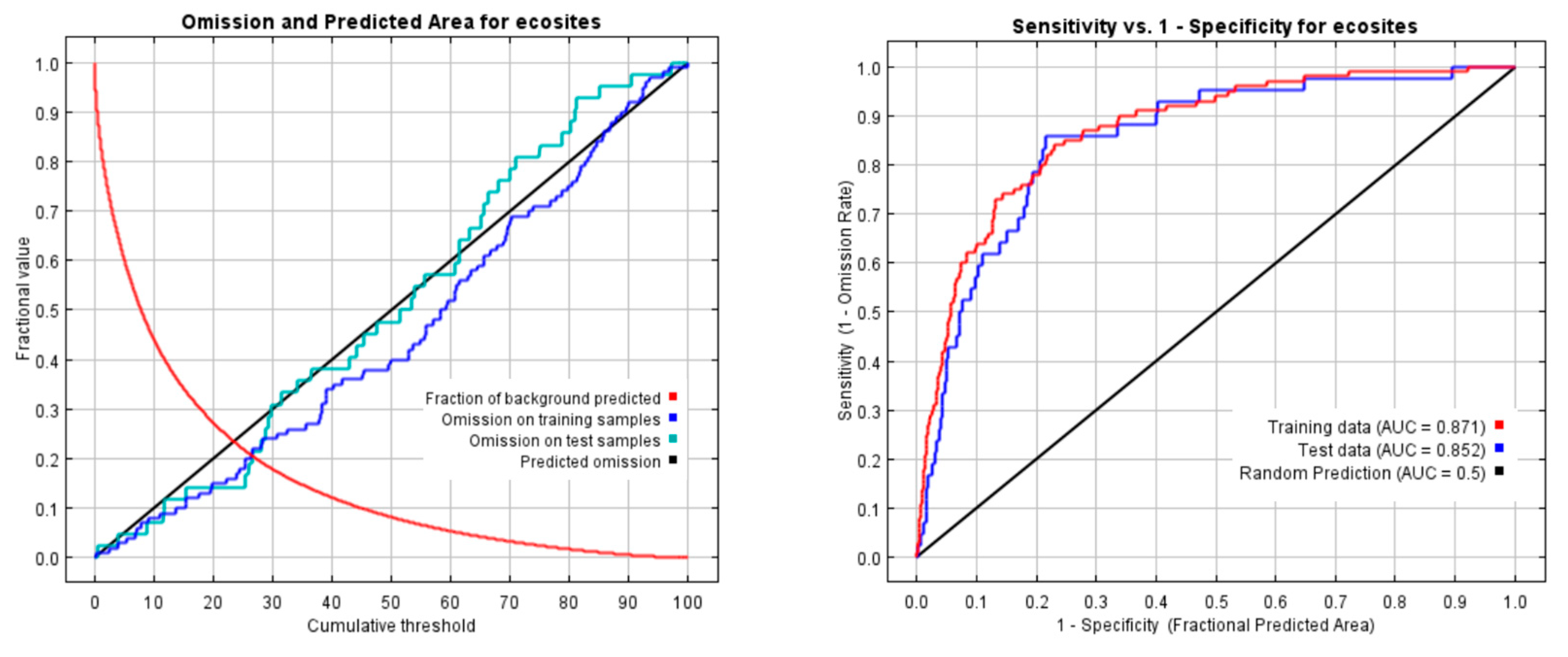
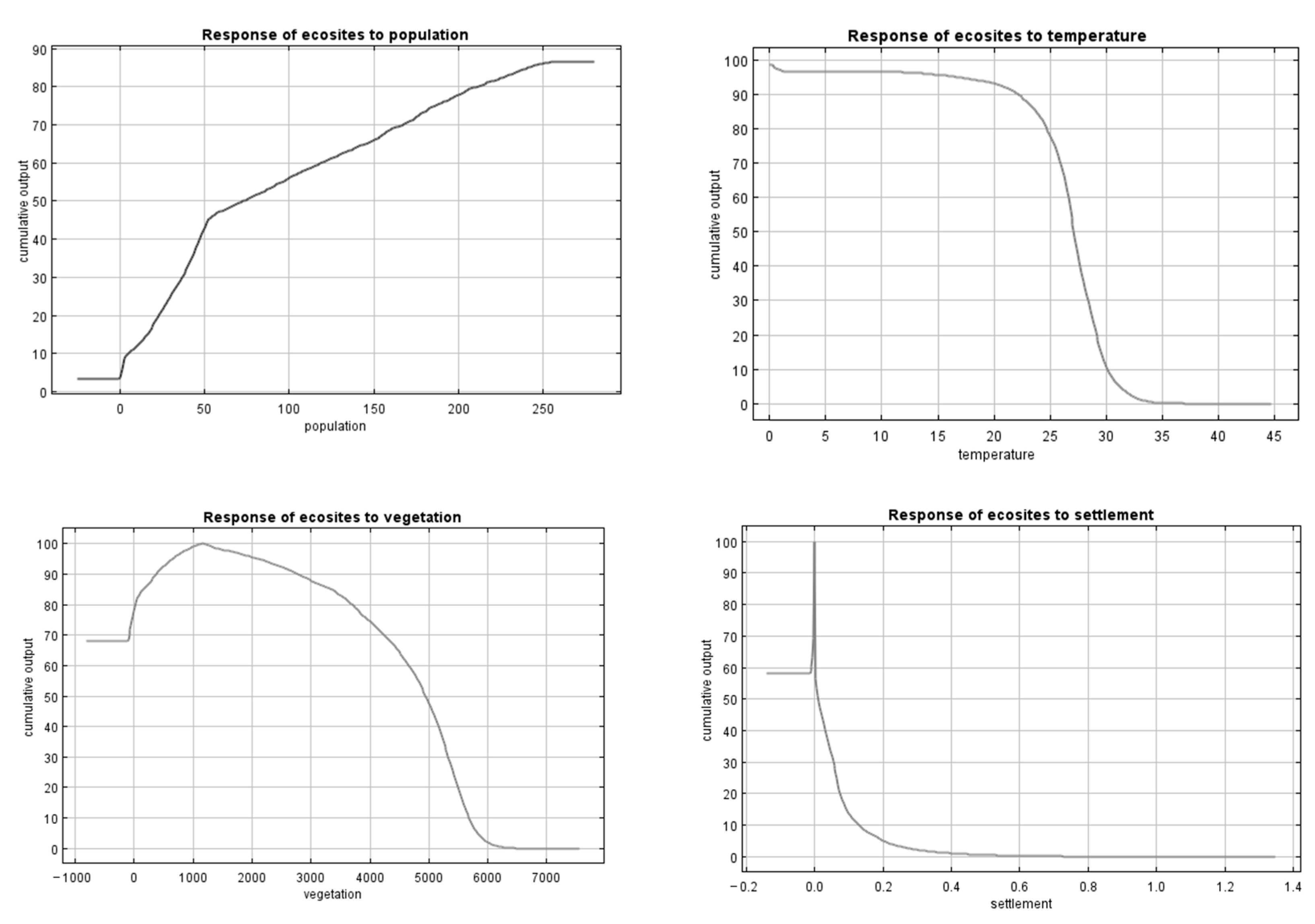
3.2. MaxEnt Model for Determining Influencing Factors
We employed the MaxEnt software (version 3.4.4) model based on species distribution to assess the potential distribution of ecotourism sites in Indonesia [28]. MaxEnt leverages maximum entropy principles to predict the distribution of observable points, such as species and environmental factors, by utilizing machine-learning techniques [28]. Observable points, designated as presence data in the program, consisted of ecotourism point data derived from Google API for the sample sites considered in this study. MaxEnt has been widely utilized in tourism studies, albeit not specifically for ecotourism, highlighting its adaptability [29,30,31].
Seven explanatory variables, including those pertaining to human effects (population and settlement), landscape characteristics (elevation, slope, and vegetation cover), and climate (temperature and precipitation), were utilized as environmental layers (details in Table 1). These data layers were obtained from the Google Earth Engine catalog to ensure compatibility across the extensive scale of our study. The data downloaded from the catalog were preprocessed in RStudio, to achieve a uniform extent, projection, and grid size for each layer. Subsequently, the data were extracted as ASCII type files to facilitate the analysis using the MaxEnt model. Figure 4 shows the maps of the environmental variables considered for MaxEnt analysis.
Table 1.
List of environmental variables for MaxEnt model analysis.
Figure 4.
Maps of the environmental variables considered for the MaxEnt model analysis.
The default settings in the MaxEnt model were applied for 500 iterations. Notably, 70% of the ecotourism point data were randomly selected for model training, whereas the remaining 30% were reserved for testing the model predictions. The model performance was evaluated using a receiver operating characteristic (ROC) curve, with the area under the curve (AUC) being greater than 0.75, indicating that the model portrayed good discrimination abilities. Note that an AUC value of 0.5 signified random guessing. Additionally, a binomial test of omission was employed to determine whether the model predicted the test localities significantly better than random predictions [38].
4. Results
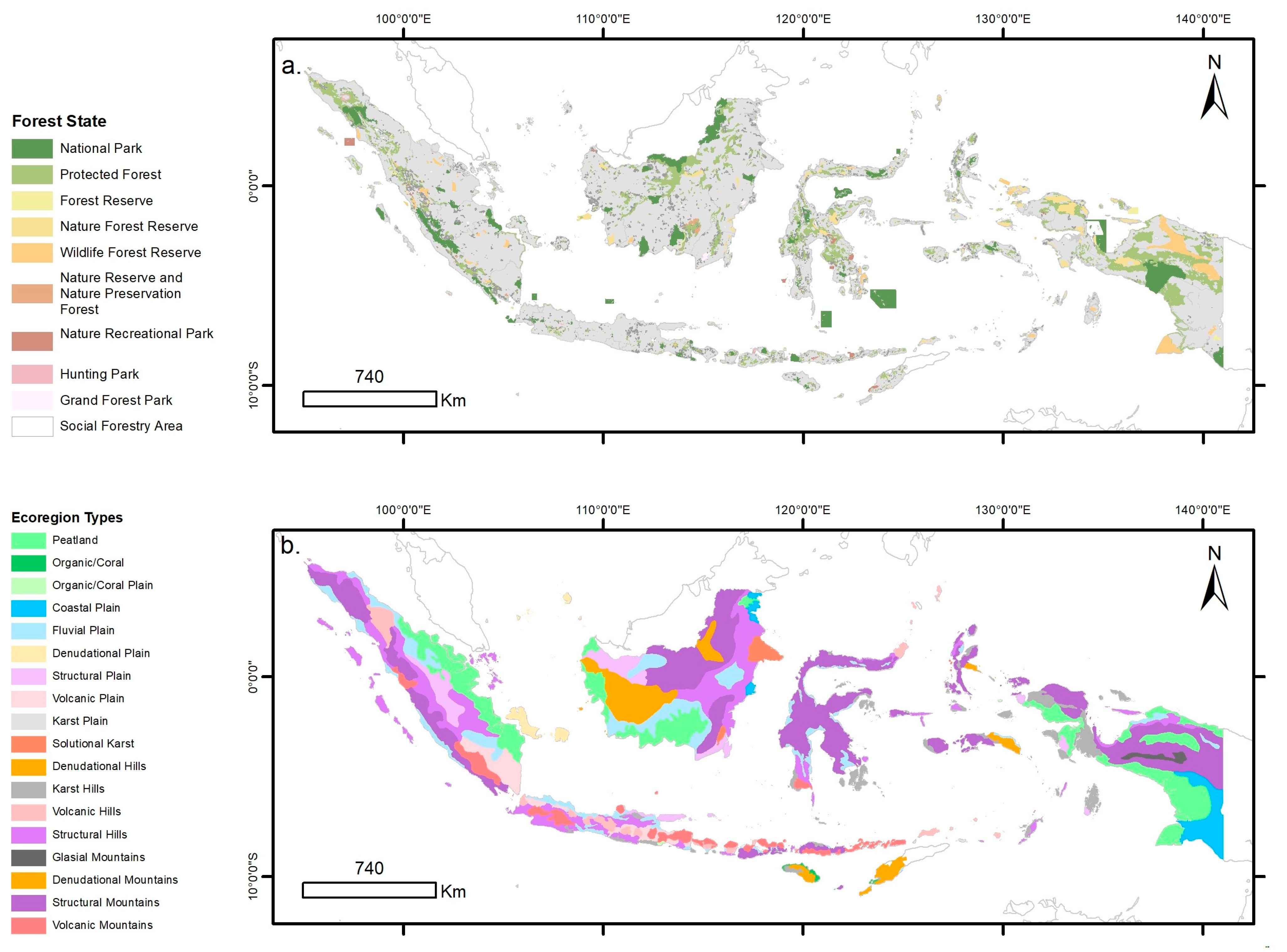
4.1. Ecotourism in Indonesia and Its Distribution within Protected Landscapes and Ecoregions
Our analysis revealed 172 sites (see Appendix A for complete list), with 91 being identified as ecotourism sites and 81 being identified as attraction sites, as illustrated in Figure 5.
Figure 5.
Distribution ecotourism sites across Indonesia, based on Google Maps API.
Our study observed multiple occurrences of the same national park in the ecotourism sites listed in Appendix A. This was due to the large size of the national parks in Indonesia, which often encompass multiple distinct ecotourism sites. For example, sites within the same national park may offer different experiences and attractions, contributing to the diversity of ecotourism opportunities. While this may appear as a limitation, it highlights the varied ecotourism offerings within these protected areas.
These results demonstrated the existence of genuine ecotourism sites in Indonesia, each of which underwent careful verification to ensure accuracy and each has been confirmed to actually exist. The ecotourism sites span every major island in Indonesia and are present in almost every province (32 out of the total 38 provinces in the country). Predominantly, the distribution of these sites was highest in Sumatra (33.72%), followed by Bali and Nusa Tenggara (15.70%) and Java (15.12%), as detailed in the Table 2. At the provincial level, the highest concentrations were observed in West Sumatra (19 sites), East Nusa Tenggara (14 sites), and West Nusa Tenggara (10 sites; Table 2).
Table 2.
Distribution of ecotourism sites across the major islands and provinces of Indonesia.
Within Indonesia’s protected landscapes (see Table 3), the distribution of ecotourism sites is primarily concentrated in the Protected Forest Area (41.28%) and National Parks Area (34.88%). Notably, four of the five social forestry schemes implemented in this region exhibited a connection to ecotourism sites, including 15 sites with Community Forest, eight sites with Village Forest, four sites with Forestry Partnership, and one site with Customary Forest.
Table 3.
Ecotourism distribution within the forest state and the social forestry scheme.
In terms of ecoregion type (see Table 4), most ecotourism sites were located in structural mountains (22.09%), structural hills (20.93%), and volcanic mountains (19.19%). Specifically, based on the ecoregion location, ecotourism is mostly situated in the Ecoregion Complex of Structural Hills of Bukit Rimbang–Bukit Baling Dangku–Bukit Tigapuluh, with 11 sites. The details of the distribution of ecotourism sites in the ecoregion complex location can be found in Appendix B.
Table 4.
Ecotourism distribution in Indonesia with respect to the ecoregion type.
4.2. Influencing Factors of Ecotourism Distribution Based on MaxEnt Model
The MaxEnt model, which was used to assess the relationship between environmental variables and ecotourism site occurrence, demonstrated satisfactory outcomes in terms of training accuracy and generalizability. The AUC values for data training and testing using MaxEnt were 0.871 and 0.852, respectively, confirming the robustness of the model. Additionally, the binomial test of omission revealed that the model significantly outperformed random predictions (p < 0.01) (see Figure 6).
Figure 6.
Analysis of omission/commission of MaxEnt model results.
With respect to the permutation importance of different variables, population emerged as the most influential (49.7%), followed by annual temperature (22.5%) and vegetation density (12.5%). Each of the remaining variables had a relative contribution of <10% (Table 5).
Table 5.
Ecotourism distribution in the major islands and provinces of Indonesia, based on different variables.
The probability of ecotourism site occurrence exhibited a positive relationship with the population size, peaking within the 50–250 population range. A higher chance of ecotourism was established in the more populated areas. Conversely, annual temperature portrayed a negative correlation with the probability of ecotourism-site occurrence, with higher temperatures being associated with lower ecotourism distribution, meaning that ecotourism is more predominantly located in colder areas; this related to the preference in terms of leisure in the colder areas. Vegetation density displayed a negative association, declining notably for values exceeding 5000. Ecotourism is commonly distributed in areas with low- to medium-density vegetation; the denser the area, the less ecotourism occurred which related to accessibility (Figure 7).
Figure 7.
Response curves for the four important variables (population, temperature, vegetation density, and settlement).
A spatial distribution analysis highlighted population as the primary factor that influences ecotourism distribution. In the jackknife test of variable importance, population emerged as the environmental variable with the highest gain (when used independently), signifying singularly valuable information.
Overall, the results indicated that the most influential factors of ecotourism distribution in Indonesia are derived from human aspects, specifically population. The MaxEnt model results for the geographic distribution of ecotourism in Indonesia indicated a high probability of presence (more than 64%), predominantly in the three main islands group: Sumatra, Java, Bali and Nusa Tenggara. These results further confirmed the presence of ecotourism sites based on the Google Maps API data used in this research, aligning with the actual distribution of ecotourism activities in Indonesia, particularly on those islands.
5. Discussion
5.1. Ecotourism in Indonesia
We carried out careful preprocessing of the raw data extracted from the Google Maps API to reveal the most representative ecotourism type in Indonesia, specifically “genuine ecotourism”. Initially, 1675 results were extracted using the keyword “ecotourism”, which were subsequently refined to 172 sites; these sites highlighted the distinction for what qualified as “ecotourism”. This approach raised the ongoing question regarding the extent to which tourism in Indonesia can be genuinely labeled as “ecotourism”. The discourse on defining ecotourism, both globally [7] and within a country [17,39], has persisted since the conceptualization of ecotourism. Determining and confirming the spectrum of ecotourism in a country is crucial for planning, managing, and shaping future policies.
Given that the selections on this ecotourism map followed the criteria for genuine ecotourism, 172 sites confirmed the existence of genuine ecotourism. Rather than persistently promoting a broad spectrum, which may lead to pseudo-ecotourism (with potential harm to the environment and communities), redirecting ecotourism development in Indonesia toward a genuine form is not just preferable, but also feasible. Furthermore, promoting various types of tourism, including ecotourism, according to its goals and in a responsible manner can be more effective in achieving sustainable development.
5.2. Relevance of This Study for the Protected Landscapes in Indonesia
Ecotourism is prominently distributed in national park areas and protected forests, which are areas where tourism activities are exceptionally limited, making ecotourism the sole permissible form of tourism in these regions. Ecotourism highlights the need for specific measures to regulate development, determine appropriate landscape interventions, and establish the carrying capacity limits of regions.
Currently, in Indonesia, business permits for natural tourism activities in such areas are governed by the Ministry of Forest and Environment, as outlined in their ministry regulations P.4/Menhut-II/2012 for national parks and P.22/Menhut-II/2012 for protected forests. Although these regulations encompass a broad spectrum of natural tourism offerings, there is limited mention of ecotourism as a specifically promoted tourism activity. Despite the detailed technical limitations imposed on natural tourism activities, there is a need for more comprehensive measures in tourism planning, particularly for ecotourism. These measures must not only minimize the environmental impact, but also contribute significantly to environmental and economic sustainability, while enhancing the overall tourist experience.
The prevalence of ecotourism within national park areas and protected forests necessitates a meticulous approach to landscape planning that goes beyond conventional tourism considerations. As an exclusive form of tourism is permitted in these ecologically sensitive regions, ecotourism requires tailored measures for sustainable development that can account for landscape sensitivity [40]. Effective ecotourism landscape planning should involve a comprehensive analysis of the unique ecological attributes of each protected area, while guiding the implementation of visitor-friendly interventions and ensuring the preservation of ecosystem integrity. Striking a delicate balance between enhancing the visitor experience and protecting the environment is of paramount importance. Potential measures may include the designation of specific ecotourism zones, development of eco-friendly infrastructure, and integration of interpretive signage to educate visitors about the ecological significance of the surroundings.
The current regulatory framework, outlined in the Ministry of Forest and Environment regulations, sets the foundation for natural tourism activities but offers limited specificity regarding ecotourism landscape planning. Future initiatives should focus on enhancing these landscape planning aspects and incorporate sustainable architectural and design elements that blend seamlessly with the natural surroundings. Collaborative efforts with local communities, scientific institutions, and environmental organizations can further enhance landscape planning in these regions, by integrating indigenous knowledge, fostering community engagement, and ensuring that the ecotourism development in the region aligns with the overarching conservation goals. By emphasizing ecotourism landscape planning, we can not only enhance the preservation of protected landscapes, but also create immersive and enriching experiences for visitors, while ensuring that they are harmoniously integrated into Indonesia’s diverse ecosystems.
5.3. Landscape Characteristics of Ecotourism in Indonesia
The landscape characteristics of ecotourism that were identified based on the ecoregion type in Indonesia offer valuable insights for developing effective landscape planning strategies. The prevalence of ecotourism in mountainous and hilly landscapes that feature structural and volcanic formations suggests the need for targeted site selection within these regions. By focusing on areas with diverse ecosystems and geological interests, landscape planning can enhance the overall ecotourism experience [41].
Recognizing the distribution of ecotourism activities in unique ecological landscapes, such as peatlands and marine ecoregions, emphasizes the importance of biodiversity conservation. Landscape planning should prioritize the protection of these distinctive ecosystems, implement strategies to minimize environmental impacts, and promote conservation efforts [42].
The presence of ecotourism in karst ecoregions, which are known for their limestone formation and geological features, provides opportunities for educational initiatives. Landscape planning can incorporate interpretive signage, guided tours, and educational programs to enhance visitors’ understanding of the geological processes and unique adaptations of flora and fauna in karst environments [42].
Note that infrastructure development in ecotourism planning should align with landscape characteristics, to ensure the creation of sustainable trails, viewing platforms, and accommodations that minimize environmental impacts. Community engagement is also vital; landscape planning can integrate local communities through initiatives, such as guided tours, homestays, and traditional craft markets.
Diverse landscapes not only offer various ecotourism experiences, e.g., biking, snorkeling, and cave exploration, but also necessitate regulatory frameworks that are tailored to each landscape type. Landscape planning should involve the development of specific guidelines, including zoning regulations, visitor quotas, and codes of conduct to safeguard landscape integrity, while allowing for responsible and sustainable ecotourism development.
Leveraging landscape characteristics in ecotourism landscape planning ensures a comprehensive and tailored approach. This approach of planning distinct strategies for unique landscape features can contribute to the sustainable development of ecotourism in Indonesia, while positively affecting conservation efforts and community well-being and ensuring the preservation of the country’s remarkable environments.
5.4. Human Effects and Effective Approaches
As an alternative facet of natural tourism in Indonesia, traditionally, ecotourism has been carried out while prioritizing environmental considerations, a trend that is evident from the use of several policies and investigations, e.g., the Natural Tourism Attraction Analysis conducted by the Ministry of Forestry since 2003. However, the significance of anthropological effects on the environment highlights the importance of an anthropological approach in the development of ecotourism in the region.
The recognition of “proximity to settlements” as a pivotal variable accentuates the need for an ecotourism strategy that not only preserves the environment, but also engages with and benefits the local communities. The prevailing inclination toward the environmental aspects of Indonesia’s ecotourism policy [10] prompts the reconsideration towards a more holistic approach that integrates anthropological considerations.
With respect to navigating the anthropological effects of ecotourism, it is crucial to view local populations as not merely passive recipients, but as active participants and stakeholders in the tourism industry. The anthropological lens encourages a nuanced understanding of local cultures, social structures, and community aspirations. This understanding is instrumental for fostering community engagement, minimizing negative social impacts, and ensuring that the benefits are distributed equally and in a fair manner.
The call for a balanced perspective transcends the dichotomy between the environmental and anthropological considerations. It advocates an integrated model that not only safeguards ecosystems, but also respects and enhances the cultural integrity of the host communities. By adopting this approach, ecotourism could become a catalyst for socioeconomic development, cultural preservation, and environmental conservation.
In conclusion, effective ecotourism-planning approaches require a delicate equilibrium between environmental preservation and anthropological sensitivity. A thoughtful integration of both perspectives can ensure the sustainable development of the ecotourism sector, while ensuring the well-being of the natural environment and the diverse communities that call these destinations home.
6. Conclusions
In this study, we identified and mapped 172 ecotourism sites across Indonesia, thereby addressing a crucial gap in the literature by providing the first comprehensive ecotourism distribution map of the country. This study presented a novel methodology that leveraged the Google Maps API to generate large-scale maps. To promote transparency and reproducibility, the detailed Rscript code employed in this study has been shared in the data availability statement, facilitating the adaptation of these methods for various mapping applications on both the national and international scales.
The significance of this study extends beyond the mere creation of thematic maps, allowing for their modification in accordance with diverse applications within Indonesia and beyond its borders. While the policy of tourism within protected landscapes has long been established, focusing on activity limitations, this study highlighted the importance of directing attention to specific areas of protected landscapes, particularly national parks and protected forests, when considering ecotourism activities. Furthermore, the identified ecoregions serve as a basis for characterizing the landscape of ecotourism in Indonesia, offering valuable insights that can guide future landscape planning in the region. It is noteworthy that most ecotourism sites were situated in mountainous and hilly landscapes.
A key takeaway of this study is the recognition of human pressures, specifically population density, as the most influential factor in ecotourism distribution. This finding underscores the need for nuanced approaches for shaping the future direction of ecotourism in Indonesia. Finally, our study serves as the baseline for informed decision-making and sustainable ecotourism planning for the diverse and ecologically rich landscapes of Indonesia.
Author Contributions
Conceptualization, perform research, and writing, S.S.; conceptualization and supervision, K.F. All authors have read and agreed to the published version of the manuscript.
Funding
This research was funded by the Management Expense Grant from Chiba University.
Data Availability Statement
The data sources (publications) have been described in detail in the Methods section of this paper. As access to some of the publications may be subject to copyright restrictions, we cannot provide links to all of the original data.
Conflicts of Interest
We declare that we do not have any commercial or associative interest that represents a conflict of interest in connection with the work submitted.
Appendix A
Table A1.
Ecotourism site’s name and location details.
Table A1.
Ecotourism site’s name and location details.
| No | Province | Name | Latitude | Longitude | Types * |
|---|---|---|---|---|---|
| 1 | Aceh | Mount Leuser National Park | 3.519292 | 97.46344 | a |
| 2 | Taman Hutan Raya Pocut Meurah Intan | 5.443313 | 95.75949 | a | |
| 3 | Teupin Layeu | 5.871526 | 95.25749 | a | |
| 4 | Wisata Hutan Mangrove Kota Langsa | 4.521636 | 98.0162 | a | |
| 5 | Bali | Bali Botanical Garden | −8.276122 | 115.1542 | b |
| 6 | Bunut Bolong | −8.386378 | 114.8737 | b | |
| 7 | Desa Wisata Wanagiri or Tourist Information | −8.243979 | 115.1035 | a | |
| 8 | Eco Mangrove Kedonganan | −8.768786 | 115.1801 | a | |
| 9 | Tahura Ngurah Rai | −8.743976 | 115.1846 | a | |
| 10 | West Bali National Park | −8.127611 | 114.4753 | a | |
| 11 | Bangka Belitung | Pantai Batu Ampar | −1.978567 | 106.1531 | b |
| 12 | Pantai Tuing Indah | −1.658443 | 106.0214 | b | |
| 13 | Belitung Mangrove Park. | −2.771407 | 107.6191 | a | |
| 14 | Eco Wisata Gusong Bugis | −2.765375 | 107.6121 | a | |
| 15 | Hkm Juru Seberang | −2.764355 | 107.6109 | a | |
| 16 | Mangrove Munjang Kurau Barat | −2.324781 | 106.2214 | a | |
| 17 | Banten | Cagar Alam Pulau Dua/Burung | −6.017053 | 106.1941 | b |
| 18 | Negri Di Atas Awan | −6.742029 | 106.332 | a | |
| 19 | Ujung Kulon National Park | −6.784694 | 105.3751 | a | |
| 20 | Gorontalo | Bukit Peyapata | 0.5934472 | 123.1482 | b |
| 21 | Puncak Lestari | 0.7172864 | 123.02 | b | |
| 22 | Ilomata River Camp | 0.6988795 | 123.1824 | a | |
| 23 | Objek Wisata Hungayono | 0.5051694 | 123.2915 | a | |
| 24 | Jakarta | Taman Wisata Alam Mangrove, Angke Kapuk | −6.10649 | 106.7369 | a |
| 25 | Jambi | Air Terjun Telun Berasap | −1.6898849 | 101.3397 | b |
| 26 | Bukit Khayangan, Sungai Penuh, Kerinci | −2.1094083 | 101.3888 | b | |
| 27 | Berbak National Park | −1.2868651 | 104.2396 | a | |
| 28 | Bukit Duabelas National Park | −1.91667 | 102.7136 | a | |
| 29 | Lake Kaco | −2.3267771 | 101.5399 | a | |
| 30 | Jawa Barat | Ekowisata Saung Alas | −6.022639 | 106.9969 | b |
| 31 | Ekowisata Tambak Alas Blanakan | −6.263679 | 107.6647 | b | |
| 32 | Hutan Mangrove Muara Blacan | −6.024626 | 107.0235 | b | |
| 33 | Bodogol Nature Reserve (Ppka Bodogol) | −6.776267 | 106.8561 | a | |
| 34 | Ecotourism Mangrove Forest Bloom Beach | −6.024533 | 106.9967 | a | |
| 35 | Ekowisata Cisantana | −6.94909 | 108.4436 | a | |
| 36 | Kampung Wisata Ciwaluh | −6.764422 | 106.8463 | a | |
| 37 | Kawasan Taman Nasional Gunung Ciremai | −6.937826 | 108.3425 | a | |
| 38 | Taman Buru Gunung Masigit Kareumbi | −6.953246 | 107.9143 | a | |
| 39 | Jawa Tengah | Umbul Songo Kopeng | −7.403025 | 110.421 | b |
| 40 | Ekowisata Kali Talang | −7.583105 | 110.462 | a | |
| 41 | Jawa Timur | Ekowisata Mangrove Lembung | −7.165048 | 113.5737 | b |
| 42 | Labuhan Mangrove Education Park–Mitra Binaan Pertamina Hulu Energi Wmo | −6.886514 | 112.9928 | b | |
| 43 | Taman Mangrove 2 | −6.885801 | 112.9822 | b | |
| 44 | Bromo Tengger Semeru National Park | −8.021875 | 112.9524 | a | |
| 45 | Mangrove Bedul Ecotourism | −8.605017 | 114.276 | a | |
| 46 | Kalimantan Barat | Betung Kerihun National Park | 1.2015147 | 113.1886 | a |
| 47 | Sentarum Lake National Park | 0.8303082 | 112.1769 | a | |
| 48 | Kalimantan Selatan | Bukit Batu | −3.504433 | 115.0718 | b |
| 49 | Bukit Matang Kaladan | −3.525424 | 115.0094 | b | |
| 50 | Goa Liang Tapah | −1.812259 | 115.6266 | b | |
| 51 | Jeram Alam Roh Tujuh Belas | −3.419173 | 115.1415 | b | |
| 52 | Mandin Mangapan | −2.860428 | 115.5502 | b | |
| 53 | Shelter 1 Kembar Muara Kahung | −3.622409 | 115.0319 | b | |
| 54 | Taman Hutan Raya Sultan Adam | −3.519414 | 114.9501 | b | |
| 55 | Villa Pantai Batakan | −4.096644 | 114.6306 | b | |
| 56 | Taman Wisata Alam Pulau Bakut | −3.215241 | 114.5576 | a | |
| 57 | Kalimantan Tengah | Resort Mangkok–Sebangau National Park | −2.580089 | 114.0412 | b |
| 58 | Camp Leakey | −2.760856 | 111.9448 | a | |
| 59 | Hutan Lindung Sei Wain | −1.1452551 | 116.8397 | a | |
| 60 | Sebangau National Park | −2.597377 | 113.6738 | a | |
| 61 | Taman Nasional Tanjung Puting | −3.055015 | 111.9184 | a | |
| 62 | Tanjung Keluang | −2.905829 | 111.7063 | a | |
| 63 | Kalimantan Timur | Pantai Indah Teluk Kaba Kaltim Indonesia | 0.3160878 | 117.5236 | b |
| 64 | Bontang Mangrove Park | 0.1456522 | 117.4976 | a | |
| 65 | Ekowisata Mangrove Kutai Timur | 0.3877682 | 117.5636 | a | |
| 66 | Wisata Alam Prevab Tnkutai | 0.5315004 | 117.4653 | a | |
| 67 | Wisata Hutan Bambu | −1.1574416 | 116.901 | a | |
| 68 | Kalimantan Utara | Kayan Mentarang National Park | 2.871817 | 115.3786 | a |
| 69 | Lampung | Waterfall Way Tayas | −5.813779 | 105.6219 | b |
| 70 | Air Terjun Way Kalam | −5.776258 | 105.6644 | a | |
| 71 | Camp Ground Danau Lebar Suoh | −5.247633 | 104.2706 | a | |
| 72 | Nirwana Keramikan | −5.237233 | 104.2593 | a | |
| 73 | Pinus Ecopark Lampung | −4.983055 | 104.4952 | a | |
| 74 | Tahura Wan Abdul Rachman (Gunung Betung) | −5.436948 | 105.1571 | a | |
| 75 | Taman Nasional Bukit Barisan Selatan | −5.448473 | 104.3516 | a | |
| 76 | Wana Wisata Tanjung Harapan | −5.224397 | 104.7919 | a | |
| 77 | Way Kambas National Park | −4.927576 | 105.7769 | a | |
| 78 | Maluku | Pantai Nh (Nitang Hahai) | −3.5170446 | 128.2277 | b |
| 79 | Manusela National Park | −3.075128 | 129.62 | a | |
| 80 | Maluku Utara | Puncak Gunung Gamalama | 0.8091909 | 127.3333 | b |
| 81 | Sajafi Island | 0.5312862 | 128.8362 | b | |
| 82 | Tanjung Waka Desa Fatkauyon. Kabupaten Kepulauan Sula, Maluku Utara | −2.4765968 | 126.05 | b | |
| 83 | Ekowisata Mangrove Maitara Tengah | 0.728751 | 127.3782 | a | |
| 84 | Nusa Tenggara Barat | Agal Waterfall | −8.54639 | 117.0502 | b |
| 85 | Air Terjun Benang Kelambu | −8.532428 | 116.337 | b | |
| 86 | Air Terjun Jeruk Manis | −8.515453 | 116.424 | b | |
| 87 | Air Terjun Tibu Bunter | −8.536218 | 116.2599 | b | |
| 88 | Goa Raksasa Tanjung Ringgit | −8.86012 | 116.5933 | b | |
| 89 | Kawasan Ekowisata Mangrove & Pengamatan Burung Gili Meno | −8.351133 | 116.0566 | b | |
| 90 | Camping Ground Ekowisata Gawar Gong | −8.506452 | 116.5341 | a | |
| 91 | Mount Tambora National Park | −8.272661 | 117.982 | a | |
| 92 | Taman Wisata Alam Gunung Tunak | −8.911051 | 116.381 | a | |
| 93 | Tanjung Ringgit | −8.861667 | 116.5944 | a | |
| 94 | Nusa Tenggara Timur | Danau Ranamese (Ranamese Lake) | −8.639167 | 120.5611 | b |
| 95 | Golo Depet | −8.65601 | 120.5609 | b | |
| 96 | Loh Buaya Komodo National Park | −8.653757 | 119.7169 | b | |
| 97 | Loh Liang–Komodo National Park | −8.569461 | 119.5007 | b | |
| 98 | Mulut Seribu Beach | −10.561694 | 123.3726 | b | |
| 99 | Niagara Murukeba | −8.747879 | 121.8252 | b | |
| 100 | Pantai Litianak | −10.755165 | 122.8999 | b | |
| 101 | Pantai Onanbalu | −10.224845 | 123.3515 | b | |
| 102 | Pantai Uiasa | −10.147299 | 123.4648 | b | |
| 103 | Taman Wisata Alam Menipo | −10.148512 | 124.1491 | b | |
| 104 | Taman Wisata Alam Ruteng | −8.641901 | 120.5592 | b | |
| 105 | Wolokoro Ecotourism | −8.81706 | 120.9341 | b | |
| 106 | Kelimutu National Park | −8.741548 | 121.7936 | a | |
| 107 | Komodo National Park | −8.527716 | 119.4833 | a | |
| 108 | Papua | Pantai Wagi | −3.3808233 | 135.1236 | b |
| 109 | Papua | Ekowisata Hutan Mangrove Pomako | −4.7977436 | 136.7697 | a |
| 110 | Papua Barat | Piaynemo Raja Ampat | −0.5642076 | 130.2708 | b |
| 111 | Sauwandarek Village | −0.5903592 | 130.6023 | b | |
| 112 | Papua Pegunungan | Lorentz National Park | −4.6297633 | 137.9727 | b |
| 113 | Riau | Air Terjun Tujuh Tingkat | −0.6174255 | 101.3224 | b |
| 114 | Bukit Tigapuluh National Park | −0.922584 | 102.4685 | a | |
| 115 | Suaka Margasatwa Rimbang Baling | −0.1835694 | 100.9355 | a | |
| 116 | Wisata Batu Belah Desa Batu Sanggan | −0.1953949 | 101.0406 | a | |
| 117 | Wisata Pulau Tilan | 1.5412444 | 101.0913 | a | |
| 118 | Sulawesi Selatan | Air Terjun Sarambu Ala | −2.704501 | 120.1323 | b |
| 119 | Bukit Bossolo | −5.501162 | 119.8437 | b | |
| 120 | Ide Beach | −2.51529 | 121.3423 | b | |
| 121 | Karawa Waterfall | −3.477889 | 119.5488 | b | |
| 122 | Balai Taman Nasional Bantimurung Bulusaraung | −4.801184 | 119.8235 | a | |
| 123 | Wisata Leang Lonrong | −4.861953 | 119.6366 | a | |
| 124 | Sulawesi Tengah | Lore Lindu National Park | −1.47495 | 120.1889 | a |
| 125 | Sulawesi Tenggara | Air Panas Wawolesea | −3.696262 | 122.3033 | b |
| 126 | Taman Nasional Rawa Aopa Watumohai | −4.438332 | 121.8733 | a | |
| 127 | Wakatobi National Park | −5.563474 | 123.9304 | a | |
| 128 | Sulawesi Utara | Obyek Wisata Pantai Batu Pinagut | 0.9202904 | 123.2694 | b |
| 129 | Pantai Lakban Ratatotok | 0.8492183 | 124.7087 | b | |
| 130 | Tanjung Kamala Watuline | 1.7277707 | 125.0225 | b | |
| 131 | Bunaken National Marine Park | 1.675843 | 124.7556 | a | |
| 132 | Ekowisata Mangrove Desa Bahoi | 1.7180899 | 125.02 | a | |
| 133 | Kek Pariwisata Likupang | 1.6801855 | 125.1575 | a | |
| 134 | Mangrove Park Bahowo | 1.5809465 | 124.8194 | a | |
| 135 | Tangkoko Batuangus Nature Reserve | 1.5082463 | 125.1882 | a | |
| 136 | Sumatera Barat | Aia Tigo Raso Nagari Koto Malintang Agam | −0.3028417 | 100.1271 | b |
| 137 | Air Terjun Langkuik | −0.4248701 | 100.28 | b | |
| 138 | Air Terjun Lubuak Bulan | −0.03658 | 100.60104 | b | |
| 139 | Air Terjun Lubuak Rantiang | −0.797728 | 100.37684 | b | |
| 140 | Air Terjun Lubuk Hitam | −1.0519767 | 100.4311 | b | |
| 141 | Air Terjun Proklamator 2022 | −0.482063 | 100.34348 | b | |
| 142 | Air Terjun Sarasah | −0.9328629 | 100.49915 | b | |
| 143 | Ngalau Loguang | −0.401077 | 100.4228 | b | |
| 144 | Pemandian Lubuk Lukum | −0.7876688 | 100.40595 | b | |
| 145 | Sarasah Bunta Waterfall | −0.1082169 | 100.6754 | b | |
| 146 | Sarasah Tanggo | −0.1372626 | 100.64031 | b | |
| 147 | Ujung Kapuri Beach | −1.1244429 | 100.36491 | b | |
| 148 | Harau Valley Waterfall | −0.10004 | 100.6659 | a | |
| 149 | Kerinci Seblat National Park | −1.7042204 | 101.26899 | a | |
| 150 | Lawang Adventure Park | −0.2807779 | 100.2416 | a | |
| 151 | Lembah Anai Waterfall | −0.483611 | 100.3384 | a | |
| 152 | Objek Wisata Taman Suaka Alam Rimbo Panti | 0.3463983 | 100.06914 | a | |
| 153 | Panorama Aka Barayun | −0.1009714 | 100.66691 | a | |
| 154 | Siberut Island National Park | −1.3174892 | 98.88916 | a | |
| 155 | Sumatera Selatan | Bukit Cogong | −3.151267 | 102.9072 | a |
| 156 | Bukit Sulap | −3.285871 | 102.8569 | a | |
| 157 | Ekowisata Hutan Lindung Bukit Botak | −3.155926 | 102.926 | a | |
| 158 | Ekowisata Kibuk | −4.045187 | 103.1414 | a | |
| 159 | Puntikayu Amusement Palembang | −2.943726 | 104.7283 | a | |
| 160 | Taman Nasional Sembilang | −2.035627 | 104.6593 | a | |
| 161 | Sumatera Utara | Air Terjun Sikulikap | 3.2454292 | 98.53399 | b |
| 162 | Air Terjun Sipitu-Pitu | 1.686052 | 98.94605 | b | |
| 163 | Bat Cave Bukit Lawang | 3.535454 | 98.11727 | b | |
| 164 | Tangkahan | 3.695156 | 98.07107 | a | |
| 165 | Toba Caldera Resort | 2.6075849 | 98.94648 | a | |
| 166 | Yogyakarta | Becici Peak | −7.902036 | 110.4375 | b |
| 167 | Hutan Pinus Asri | −7.920921 | 110.4356 | b | |
| 168 | Hutan Pinus Pengger | −7.871204 | 110.4595 | b | |
| 169 | Mojo Gumelem Hill | −7.957364 | 110.4334 | b | |
| 170 | Hutan Pinus Mangunan | −7.925816 | 110.4318 | a | |
| 171 | Rph Mangunan | −7.930329 | 110.4297 | a | |
| 172 | Wisata Air Terjun Sri Gethuk | −7.943178 | 110.4892 | a |
* Type a refer to ecotourism sites. Type b refer to attraction sites.
Appendix B
Table A2.
Number of ecotourism sites in the ecoregion complex of Indonesia.
Table A2.
Number of ecotourism sites in the ecoregion complex of Indonesia.
| No | Name of Ecoregion Complex | Number of Ecotourism Sites |
|---|---|---|
| 1 | Marine Ecoregion | 11 |
| 2 | Ecoregion Complex of Structural Hills of Bukit Rimbang–Bukit Baling Dangku–Bukit Tigapuluh | 11 |
| 3 | Ecoregion Complex of Kerinci Seblat Structural Mountains–Bukit Barisan Selatan | 11 |
| 4 | Ecoregion Complex of Lore Lindu Structural Mountains–Bogani Nani Wartabone | 10 |
| 5 | Ecoregion Complex of Volcanic Mountains Bali–Lombok | 8 |
| 6 | Ecoregion Complex of Meratus Structural Mountains | 7 |
| 7 | Ecoregion Complex of Wonosari Structural Hills–Trenggalek | 7 |
| 8 | Ecoregion Complex of Flores Volcanic Mountains | 7 |
| 9 | Ecoregion Complex of Benakat Semangus Volcanic Plain–Way Kambas | 6 |
| 10 | Ecoregion Complex of Cilegon Indramayu Fluvial Plain–Pekalongan | 6 |
| 11 | Ecoregion Complex of North South Maninjau Volcanic Mountains–Mount Sado | 6 |
| 12 | Ecoregion Complex of Meratus Structural Hills | 5 |
| 13 | Ecoregion Complex of Denudational Plain Kep. Bangka Belitung | 5 |
| 14 | Ecoregion Complex of Peat Plains of S. Katingan–S. Sebangau | 4 |
| 15 | Ecoregion Complex of Volcanic Mountains G. Halimun–G. Salak–M. Sawal | 4 |
| 16 | Ecoregion Complex of Manembo Nembo Volcanic Hills–Duasudara–Tangkoko | 3 |
| 17 | Ecoregion Complex of Janthoi Structural Mountains–Mount Leuser | 3 |
| 18 | Ecoregion Complex of Peat Plains of the East Coast of Sumatra | 3 |
| 19 | Ecoregion Complex of Gumay Tebing Tinggi Volcanic Mountains–Gunung Raya | 3 |
| 20 | Ecoregion Complex of Flores Structural Hills | 2 |
| 21 | Ecoregion Complex of Sibolangit–Dolok–Sipirok Volcanic Hills | 2 |
| 22 | Ecoregion Complex of Volcanic Hills of Mount Slamet–Merapi | 2 |
| 23 | Ecoregion Complex of Bangkalan Structural Plain–Sumenep | 2 |
| 24 | Ecoregion Complex of Structural Hills of Bali–Lombok | 2 |
| 25 | Ecoregion Complex of Mahakam Structural Mountains | 2 |
| 26 | Ecoregion Complex of Structural Hills of the West Coast of Sumatra | 2 |
| 27 | Ecoregion Complex of Kuala Kuayan Fluvial Plain–Kasongan | 2 |
| 28 | Ecoregion Complex of G.Ceremai Volcanic Hills | 2 |
| 29 | Ecoregion Complex of Volcanic Mountains of North Maluku | 2 |
| 30 | Ecoregion Complex of Organic/South Central Timor Coral | 2 |
| 31 | Ecoregion Complex of Barumun Structural Mountains–Malampah Alahan Panjang | 2 |
| 32 | Ecoregion Complex of P. Waigeo Structural Mountains | 1 |
| 33 | Ecoregion Complex of Volcanic Hills of Bali–Lombok | 1 |
| 34 | Ecoregion Complex of Denudational Mountains P. Seram | 1 |
| 35 | Ecoregion Complex of Kuis River Peat Plain–Bapai River. | 1 |
| 36 | Ecoregion Complex of Organic/Coral Plains P. Misol–P. Kofiau | 1 |
| 37 | Ecoregion Complex of Organic/Coral Bali–Lombok | 1 |
| 38 | Ecoregion Complex of Jayawijaya Route Structural Hills. | 1 |
| 39 | Ecoregion Complex of Malino Volcanic Mountains | 1 |
| 40 | Ecoregion Complex of Ujung Kulon Structural Hills–Cikepuh- Leuweung Sancang | 1 |
| 41 | Ecoregion Complex of Idirayeuk Fluvial Plain–Binjai–Sutan Syarif Qasim | 1 |
| 42 | Ecoregion Complex of Denudational Mountains of South-Central Timor | 1 |
| 43 | Ecoregion Complex of Sumbawa Volcanic Mountains | 1 |
| 44 | Ecoregion Complex of Cut Nyak Dhien- Lampahan- Langkat Structural Hills | 1 |
| 45 | Ecoregion Complex of Denudational Hills of North Maluku | 1 |
| 46 | Ecoregion Complex of G. Gogugu–S. Ranoyapo Structural Hills | 1 |
| 47 | Ecoregion Complex of Fluvial Plains of Bali–Lombok | 1 |
| 48 | Ecoregion Complex of Structural Hills of North Maluku | 1 |
| 49 | Ecoregion Complex of Bantimurung Karst Hills–Bulusaraung | 1 |
| 50 | Ecoregion Complex of Central Structural Mountains of Papua | 1 |
| 51 | Ecoregion Complex of Siranggas Structural Hills–Batang Girls | 1 |
| 52 | Ecoregion Complex of S. Darau Structural Plain | 1 |
| 53 | Ecoregion Complex of Sentarum Fluvial Plain | 1 |
| 54 | Ecoregion Complex of Tesso Nilo Structural Plain–Bukit Duabelas | 1 |
| 55 | Ecoregion Complex of P. Seram Structural Mountains | 1 |
| 56 | Ecoregion Complex of Bromo Volcanic Mountains–Yang Plateau–Baluran | 1 |
| 57 | Ecoregion Complex of Alas Purwo Fluvial Plain | 1 |
| 58 | Ecoregion Complex of Cani Sirenreng Structural Hills | 1 |
| 59 | Ecoregion Complex of Denudational Hills of South-Central Timor | 1 |
| Grand Total | 172 |
References
- Buckley, R. (Ed.) Environmental Impacts of Ecotourism; Ecotourism Book Series; CABI Pub: Wallingford, UK; Cambridge, MA, USA, 2004; ISBN 978-0-85199-810-7. [Google Scholar]
- Boo, E. Ecotourism: The Potentials and Pitfalls: Country Case Studies; World Wildlife Fund: Baltimore, MD, USA, 1990. [Google Scholar]
- Lasso, A.H.; Dahles, H. A Community Perspective on Local Ecotourism Development: Lessons from Komodo National Park. Tour. Geogr. 2023, 25, 634–654. [Google Scholar] [CrossRef]
- Hatma Indra Jaya, P.; Izudin, A.; Aditya, R. The Role of Ecotourism in Developing Local Communities in Indonesia. J. Ecotourism 2022, 23, 20–37. [Google Scholar] [CrossRef]
- Butarbutar, R.R.; Soemarno, S. Community Empowerment Efforts in Sustainable Ecotourism Management in North Sulawesi, Indonesia. Indones. J. Environ. Sustain. Dev. 2012, 3. [Google Scholar]
- Kia, Z. Ecotourism in Indonesia: Local Community Involvement and The Affecting Factors. J. Gov. Public Policy 2021, 8, 93–105. [Google Scholar] [CrossRef]
- Fennell, D.A. Ecotourism, 4th ed.; Routledge: London, UK; New York, NY, USA, 2015; ISBN 978-0-415-82964-9. [Google Scholar]
- Wearing, S.; Neil, J. Ecotourism: Impacts, Potentials and Possibilities? 2nd ed.; Butterworth-Heinemann: Amsterdam, The Netherlands; Boston, MA, USA; London, UK, 2009; ISBN 978-0-7506-6249-9. [Google Scholar]
- Purnomo, M.; Maryudi, A.; Dedy Andriatmoko, N.; Muhamad Jayadi, E.; Faust, H. The Cost of Leisure: The Political Ecology of the Commercialization of Indonesia’s Protected Areas. Environ. Sociol. 2022, 8, 121–133. [Google Scholar] [CrossRef]
- Sisriany, A.; Furuya, K. Ecotourism Policy Research Trends in Indonesia, Japan, and Australia. J. Manaj. Hutan Trop. J. Trop. For. Manag. 2020, 26, 178–188. [Google Scholar] [CrossRef]
- Masser, I. All Shapes and Sizes: The First Generation of National Spatial Data Infrastructures. Int. J. Geogr. Inf. Sci. 1999, 13, 67–84. [Google Scholar] [CrossRef]
- Bretz, K.J. Indonesia’s One Map Policy: A Critical Look at the Social Implications of a’Mess’. Senior Thesis, University of South Carolina, Columbia, SC, USA, 2017. Available online: https://scholarcommons.sc.edu/senior_theses/134/ (accessed on 12 March 2024).
- Fisher, R.P.; Myers, B.A. Free and Simple GIS as Appropriate for Health Mapping in a Low Resource Setting: A Case Study in Eastern Indonesia. Int. J. Health Geogr. 2011, 10, 15. [Google Scholar] [CrossRef]
- Kanthi, N.S.; Purwanto, T.H. Application of OpenStreetMap (OSM) to Support the Mapping Village in Indonesia. IOP Conf. Ser. Earth Environ. Sci. 2016, 47, 012003. [Google Scholar] [CrossRef]
- Putra, T.Y.D.; Sekimoto, Y.; Shibasaki, R. Toward the Evolution of National Spatial Data Infrastructure Development in Indonesia. ISPRS Int. J. Geo-Inf. 2019, 8, 263. [Google Scholar] [CrossRef]
- Hitchcock, M.; Yamashita, S.; Adams, K.M.; Borchers, H.; Bennett, J.; Richter, L. (Eds.) Tourism in Southeast Asia: Challenges and New Directions; Nias Press: Copenhagen, Denmark, 2009; ISBN 978-87-7694-033-1. [Google Scholar]
- Cochrane, J. New Directions in Indonesian Ecotourism. In Tourism in Southeast Asia: Challenges and New Directions; Nias Press: Copenhagen, Denmark, 2009; pp. 254–269. [Google Scholar]
- Government Regulation No. 23 of 2021 on Forestry Implementation. Available online: http://peraturan.bpk.go.id/Details/161853/pp-no-23-tahun-2021 (accessed on 24 January 2024).
- Sahide, M.A.K.; Fisher, M.R.; Erbaugh, J.T.; Intarini, D.; Dharmiasih, W.; Makmur, M.; Faturachmat, F.; Verheijen, B.; Maryudi, A. The Boom of Social Forestry Policy and the Bust of Social Forests in Indonesia: Developing and Applying an Access-Exclusion Framework to Assess Policy Outcomes. For. Policy Econ. 2020, 120, 102290. [Google Scholar] [CrossRef]
- Erbaugh, J.T. Responsibilization and Social Forestry in Indonesia. For. Policy Econ. 2019, 109, 102019. [Google Scholar] [CrossRef]
- Hamstead, Z.A.; Fisher, D.; Ilieva, R.T.; Wood, S.A.; McPhearson, T.; Kremer, P. Geolocated Social Media as a Rapid Indicator of Park Visitation and Equitable Park Access. Comput. Environ. Urban Syst. 2018, 72, 38–50. [Google Scholar] [CrossRef]
- Hochman, N.; Manovich, L. Zooming into an Instagram City: Reading the Local through Social Media. First Monday 2013, 18. [Google Scholar] [CrossRef]
- Dunkel, A. Visualizing the Perceived Environment Using Crowdsourced Photo Geodata. Landsc. Urban Plan. 2015, 142, 173–186. [Google Scholar] [CrossRef]
- Martí, P.; Serrano-Estrada, L.; Nolasco-Cirugeda, A. Social Media Data: Challenges, Opportunities and Limitations in Urban Studies. Comput. Environ. Urban Syst. 2019, 74, 161–174. [Google Scholar] [CrossRef]
- Ministry of Forestry and Environment Indonesia. KLHK. Available online: https://Sigap.Menlhk.Go.Id/KLHK (accessed on 28 October 2023).
- Ministy of Environment. Description of the Ecoregion Map on the Island/Archipelago; Deputy for Environmental Management, Ministy of Environment: Jakarta, Indonesia, 2013; ISBN 978-602-8773-09-6.
- Andréfouët, S.; Paul, M.; Farhan, A.R. Indonesia’s 13558 Islands: A New Census from Space and a First Step towards a One Map for Small Islands Policy. Mar. Policy 2022, 135, 104848. [Google Scholar] [CrossRef]
- Phillips, S.J.; Dudik, M.; Schapire, R.E. [Internet] Maxent Software for Modeling Species Niches and Distributions (Version 3.4.1). Available online: http://biodiversityinformatics.amnh.org/open_source/maxent/ (accessed on 1 December 2023).
- Kim, G.; Kang, W.; Park, C.R.; Lee, D. Factors of Spatial Distribution of Korean Village Groves and Relevance to Landscape Conservation. Landsc. Urban Plan. 2018, 176, 30–37. [Google Scholar] [CrossRef]
- Arslan, E.S.; Örücü, Ö.K. MaxEnt Modelling of the Potential Distribution Areas of Cultural Ecosystem Services Using Social Media Data and GIS. Environ. Dev. Sustain. 2021, 23, 2655–2667. [Google Scholar] [CrossRef]
- Yan, Y.; Kuo, C.-L.; Feng, C.-C.; Huang, W.; Fan, H.; Zipf, A. Coupling Maximum Entropy Modeling with Geotagged Social Media Data to Determine the Geographic Distribution of Tourists. Int. J. Geogr. Inf. Sci. 2018, 32, 1699–1736. [Google Scholar] [CrossRef]
- Pesaresi, M.; Ehrlich, D.; Ferri, S.; Florczyk, A.; Carneiro, F.S.M.; Halkia, S.; Julea, A.M.; Kemper, T.; Soille, P.; Syrris, V. Operating Procedure for the Production of the Global Human Settlement Layer from Landsat Data of the Epochs 1975, 1990, 2000, and 2014. Available online: https://publications.jrc.ec.europa.eu/repository/handle/JRC97705 (accessed on 24 January 2024).
- Population Count, v4.11: Gridded Population of the World (GPW), v4|SEDAC. Available online: https://sedac.ciesin.columbia.edu/data/set/gpw-v4-population-count-rev11 (accessed on 24 January 2024).
- Didan, K. MODIS/Terra Vegetation Indices 16-Day L3 Global 250m SIN Grid V061. 2021, Distributed by NASA EOSDIS Land Processes Distributed Active Archive Center. Available online: https://doi.org/10.5067/MODIS/MOD13Q1.061 (accessed on 24 January 2024).
- NASADEM Merged DEM Global 1 Arc Second V001. Available online: https://cmr.earthdata.nasa.gov/search/concepts/C1546314043-LPDAAC_ECS.html (accessed on 24 January 2024).
- OpenLandMap Long-Term Land Surface Temperature Monthly Day-Night Difference|Earth Engine Data Catalog. Available online: https://developers.google.com/earth-engine/datasets/catalog/OpenLandMap_CLM_CLM_LST_MOD11A2-DAYNIGHT_M_v01 (accessed on 24 January 2024).
- Brocca, L.; Filippucci, P.; Hahn, S.; Ciabatta, L.; Massari, C.; Camici, S.; Schüller, L.; Bojkov, B.; Wagner, W. SM2RAIN–ASCAT (2007–2018): Global Daily Satellite Rainfall Data from ASCAT Soil Moisture Observations. Earth Syst. Sci. Data 2019, 11, 1583–1601. [Google Scholar] [CrossRef]
- Phillips, S.J.; Dudík, M. Modeling of Species Distributions with Maxent: New Extensions and a Comprehensive Evaluation. Ecography 2008, 31, 161–175. [Google Scholar] [CrossRef]
- Stewart, W.P.; Sekartjakrarini, S. Disentangling Ecotourism. Ann. Tour. Res. 1994, 21, 840–842. [Google Scholar] [CrossRef]
- Lundmark, L.J.T.; Fredman, P.; Sandell, K. National Parks and Protected Areas and the Role for Employment in Tourism and Forest Sectors: A Swedish Case. Ecol. Soc. 2010, 15, art19. [Google Scholar] [CrossRef]
- Açıksöz, S.; Cetinkaya, G.C.; Uzun, O.; Erduran Nemutlu, F.; Ilke, E.F. Linkages among Ecotourism, Landscape and Natural Resource Management, and Livelihood Diversification in the Region of Suğla Lake, Turkey. Int. J. Sustain. Dev. World Ecol. 2016, 23, 15–27. [Google Scholar] [CrossRef]
- Fennell, D.A. Ecotourism Programme Planning; CABI Pub: Wallingford, UK; New York, NY, USA, 2002; ISBN 978-0-85199-610-3. [Google Scholar]
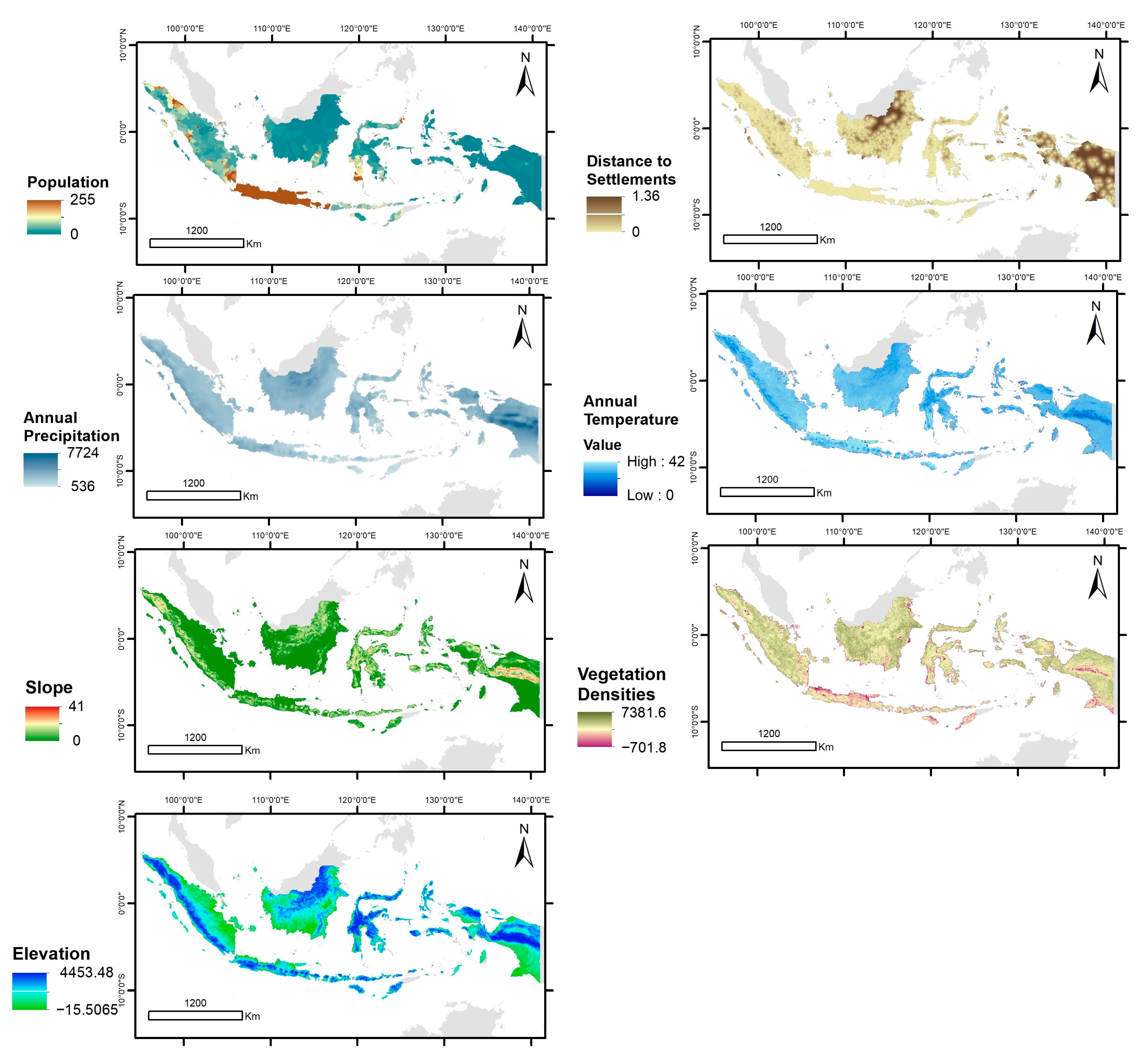
Disclaimer/Publisher’s Note: The statements, opinions and data contained in all publications are solely those of the individual author(s) and contributor(s) and not of MDPI and/or the editor(s). MDPI and/or the editor(s) disclaim responsibility for any injury to people or property resulting from any ideas, methods, instructions or products referred to in the content. |
© 2024 by the authors. Licensee MDPI, Basel, Switzerland. This article is an open access article distributed under the terms and conditions of the Creative Commons Attribution (CC BY) license (https://creativecommons.org/licenses/by/4.0/).