Abstract
The intensive pollution of vast areas after the Chernobyl accident, especially in the territories of Ukraine, Russia, and Belarus, has not only become a serious environmental issue, but also presents wide methodological opportunities for studying the functioning of natural systems. The proposed work is a generalization of the results of studies on the migration of 137Cs in the runoff of river sediments, which were carried out in the basin of the Upa River for over 30 years after the accident. This basin is one of the most radioactively contaminated and studied in Central Russia. Over the past three decades, under the conditions of the decreasing snowmelt runoff in the spring and reduced share of cultivated land over the post-Soviet period, the intensity of the 137Cs transfer has decreased. The 137Cs deposit losses associated with erosion activities do not exceed a few percent. Most of the mobilized sediments and sediment-associated radionuclides accumulate in dry valleys or artificial reservoirs. With a general reduction in the durations of floods, rivers have become the predominant channels for the transfer of sediment yield and particulate pollutants. The exploration of the vertical distribution of the 137Cs in the accumulative strata makes it possible to identify the changes in the sediment budgets of the rivers and their radioecological consequences.
1. Introduction
The sediment budget approach is a basic one in the framework of fluvial geomorphology, and it has turned out to be an effective but rather labour-intensive tool [1,2,3,4,5]. A sediment budget study should not be considered an alternative to regular stationary observations [6]. If monitoring data are not available or are scarce, a sediment budget is the best approach to estimate the volumes and determine the sources of the sediment flows within and beyond river basins. The spatial–temporal windows for the evaluation of the sediment budget depend on the study goals, and this approach can be used for sites within different areas [7,8,9,10,11,12,13].
However, individual studies may not sufficiently cover the object under study. In this regard, summarizing a set of works is required to obtain a holistic result. Such generalizations allow working with relatively large objects from the regional [14,15,16,17,18,19,20] to the global scale [21,22,23,24,25]. The result makes it possible to find solutions to specific environmental issues [26,27,28,29,30] and optimal land use management strategies [31,32,33,34].
We can successfully apply the sediment budget approach to mass-balance studies on the transfer of sediment-associated pollutants. Some of the pollutants that enter the natural environment are reliably bound by soil particles and become an additional characteristic of the transported sediments. Therefore, we can estimate the redistribution of these pollutants based on the sediment budget. The intensive pollution of river basins, including radionuclide contamination, largely actualizes the application of this approach [35,36,37,38,39,40,41,42,43,44].
On the one hand, the radioactive contamination of river basins after major technogenic accidents, such as the incidents at the Chernobyl and Fukushima nuclear power stations, is a serious environmental challenge [45]. The long-term ecological health of an environment requires a detailed study of the sediment redistribution [41,46,47,48,49,50].
The consequences of the accident at the Fukushima nuclear power plant have been studied in great detail, with particular emphasis on the study of the 137Cs redistribution in particulate and in dissolved form [49,51,52,53]. Due to the detailed monitoring of the features of 137Cs fallout and its lateral migration in various parts of the fluvial network, the volumes of sediment and sediment-associated 137Cs redeposited inside the basins of small and medium-sized rivers and their entry into the world ocean were revealed [54,55]. Separately, the influence of the decontamination of agricultural lands on the 137Cs migration from the continental part to the world ocean was studied [26]. The latest generalizations of studies in the contaminated area after the Fukushima accident include, among other things, comparisons of the 137Cs lateral migration in the contaminated areas of Fukushima and Chernobyl [29]. However, such comparison was made with only for areas located at a small distance from the Chernobyl nuclear power plant [49,56,57]. Within the territory of Central Russia, researchers have conducted the most detailed sediment budget studies on the redistribution and transfer of sediment-associated 137Cs in the Upa River basin. The given basin is located at a large distance from Chernobyl within the Central Russian Upland, with a high proportion of agricultural land and an extended dry valley network. This area is fundamentally different from the mostly forested lowland surrounding the Chernobyl NPP, as well as the heavily forested mountainous areas of the island of Honshu, which were contaminated after the Fukushima accident. In this regard, it is especially important to understand the features of the redistribution of sediments and sediment-associated 137Cs along the pathway of their transportation from arable slopes to permanent watercourses.
Generalization of a large number of publications prepared on the basis of detailed studies in the Upa river basin, undertaken over a thirty-year period, made it possible to systematize the results of the studies performed and to assess the redistribution of the sediments and sediment-associated 137Cs in different chains of the fluvial network over this long time interval corresponding to the half-life of 137Cs.
Moreover, technogenic fallout radionuclides present broad methodological prospects for integrated studies on fluvial processes. 137Cs of different origins, including from bomb-derived fallout (with the maximum in 1963) and the Chernobyl-derived fallout, acts as an object of study and a convenient technogenic tracer for the quantification of the processes of sediment mobilization, transport, and redeposition.
In the centre of the European part of Russia, 137Cs has established itself as a reliable chronological marker of the territories affected by the accident at the Chernobyl NPP. The almost instant fallout of 137Cs on the land surface has made it possible to accurately determine the accumulation rates for the period from April to May 1986. The high level of 137Cs activity concentration in the contaminated sediments reduces the time required for gamma spectrometric measurements. However, if the Chernobyl-derived 137Cs deposits are many times greater than bomb fallouts, then it becomes practically impossible to distinguish the bomb-derived peak of the 137Cs concentration decades after the accident [50]. The duration of the post-Chernobyl period overlaps with the time frame for assessing the current climate norm (1991–2020). However, substantial changes in the arable land and land use systems on the East European Plain (EEP), which are associated with the economic crisis of the early 1990s, are critical and should be considered [58,59]. A major portion of the river basins of the EEP are characterized by intense anthropogenic impacts. Their sediment yields are primarily formed by the contribution of the sheet and rill erosion on the arable slopes [60]. At the same time, the rate of gully erosion is mostly decreasing [61]. Most of the mobilized material accumulates within small catchments, which leads to accumulation on the valley bottoms and a substantial decrease in the stream net density [62,63,64,65,66,67,68,69]. Within the territory of the East European Plain, soil erosion primarily occurs on the cultivated slopes during the spring snowmelt and after high-intensity rains. The complexity and spatiotemporal nonuniformity of the sediment redistribution process is the reason that researchers can only undertake detailed field studies for relatively small catchments. Hence, the extrapolation of the obtained results over larger areas is required. However, even in this case, the field observations, collection, and processing of the material are time-consuming. Studies may take place in different months, years, or even decades. As a result, the final assessment of the sediment redistribution within a river basin is not analogous to an “instant photograph” but rather to a “collage” of multitemporal images. Therefore, we can only assess long-term trends in the transformation of the erosion and deposition rates due to the global and regional climate and land use changes.
Our purpose was to assess the sediment budget for 137Cs transported in two relatively large (>1000 km2) sub-basins of the Upa River basin over the post-Chernobyl period. We based the assessment on a generalization of the experience of studying the sediment redistribution within small key catchments, river floodplains, and sediment deposition in artificial reservoirs. We discuss and propose new prospects for further studies of 137Cs redistribution in areas affected by the Chernobyl fallout, located at a large distance from Chernobyl NPP.
2. Possible Transfer Paths of Particulate Chernobyl-Derived 137Cs
The Chernobyl fallout urged the rapid development of an appropriate model for forecasting the transfer of radionuclides in rivers that considers the particularities of the radionuclide behaviour in soil–water systems [70,71,72]. Researchers first observed the Chernobyl-derived cesium in the water and suspended sediments in the spring of 1987 in the Middle Dnieper basin. They made observations of the basin, and they recorded the maximum 134Cs and 137Cs concentrations in the watercourses with the highest shares of arable lands in their catchments [73]. The erosion on the cultivated slopes of interfluves is arguably the major source of the particulate radiocesium in the sediment yields of the rivers.
The basins of the lowland rivers of the temperate zone, with high anthropogenic impacts, are characterized by strong functional geomorphic disconnectivity and the predominance of intrabasin accumulation over the removal of material beyond the outflow gate [74,75,76,77]. There are a large number of accumulation sinks that trap the eroded material. Sediment sinks can either be natural (the flattening of slopes, areas with sharp changes in their surface roughness coefficients due to changes in the characteristics of the vegetation cover, etc.) or artificial (forest belts, ploughing shafts, the embankments of road networks, reservoir dams, etc.) origin. The trap efficiency of sediment sinks depends not only on their characteristics, but also on the mechanism of the sediment transfer (Figure 1).
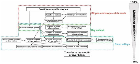
Figure 1.
Possible paths of contaminated sediments in river basins.
The main agents of the sediment mobilization on arable slopes are sheet, rill, and ephemeral gully erosion. A considerable portion of sediment, transported by sheet and rill erosion, is usually redeposited on the slope or at its foot. The morphometries of the slopes and the features of their longitudinal and transverse profiles largely determine the presence and intensity of the intraslope accumulation. The shape of the transverse profile determines the ability of a slope to disperse or concentrate runoff [78,79]. Otherwise, if sediments enter a network of slope hollows, then due to the concentration of the slope runoff, their probability of crossing the lower boundary of an arable slope that is limited by arable land (plough rampart) substantially increases [48,80]. Ephemeral gully erosion on arable land usually occurs in two forms: (1) deep furrows that form due to a single storm and/or melt runoff; (2) erosion and accumulation in the thalwegs of the larger and relatively stable slope hollows.
Gully erosion makes a substantial contribution to the mobilization and transport of sediments, especially in cases when the tops of active gullies are located on ploughed slopes. The sediments that move along the gullies almost always reach the bottoms of dry valleys, bypassing the intraslope accumulation zones, as well as the ploughed and grassy sides of the valley. The slope gullies have not increased since the post-Chernobyl period in the Upa River basin. However, the possible input of gully erosion should not be completely ignored, considering climate change and the expansion of the application of irrigated agriculture in the basin.
The sediments that overcome the lower boundaries of cultivated fields are partially redeposited on the sides of the valley that are covered with natural vegetation. The rest of the eroded materials enter the dry valley bottoms. From a quantitative point of view, overcoming the lower boundary of the arable slope and the transport along the sides of the valley is a poorly studied stage in the process of sediment transfer. Changes in the slope and the roughness coefficient of the slope surface have led to a sharp transformation in the slope runoff within a relatively compact zone. We lack quantitative data on the rates and volumes of the accumulation on the sides of the valleys due to the need to collect a large number of samples for the correct evaluation of the sediment volume redeposited during fixed time intervals.
The pathways of the subsequent sediment transfer that enters the bottoms of dry valleys are determined by their position in the structure of the fluvial network of the EEP river basins. Part of the sediment may be transported by temporary streams formed during melt runoff, and in some cases during extreme rains, from along the bottoms of the dry valleys to the bottoms of the river valleys. Another portion accumulates at the foots of the sides of the valley in the form of trails or pluvial fans, as well as further along the bottoms of dry valleys, depending on the direction and turbidity of the water runoff, which results in an uneven increase in the bottom elevations; this contributes to the gradual increase in the inclination of the dry valley bottom surfaces, which is one of the key factors in the formation of bottom gullies, and which represents a special mechanism for the sediment transport along the valley [48].
Upon reaching the river valleys, the material can either be deposited in the form of plumes or proluvial fans on the surface of the floodplain or reach the river channel. Furthermore, the eroded material continues to become part of the river sediment. Partial sediments are redeposited onto the surface of the floodplain during periods of rising water levels (floodplain accumulation). The reverse process (the transfer of matter from the floodplain to the channel) is also not excluded. However, under the conditions of the decreasing volume and duration of the flooding [81], this is only a marginal component of the sediment budget.
The Upa River basin is characterized by the construction of artificial reservoirs in both the dry and river valleys. Such reservoirs are traps for the greater portion of the sediments that are transported by the water flows that form upstream of the dam [82,83,84,85,86,87,88]. According to the results of studies on small reservoirs in the forest-steppe zone of Central Russia, the trap efficiency of these reservoirs is 96.4–99.7% [89].
3. Study Area
The Upa River basin occupies a territory of about 9500 km2, and it is located in the northern part of the Central Russian Upland in the Tula region. According to the Köppen–Geiger classification [90], this area belongs to the Dfb zone, which is characterized by a cold climate with warm summers and no dry season. The annual precipitation decreases from northwest to southeast from 630 to 592 mm, and in the warm season, there is an average of 460 mm of rainfall.
The soil cover within the interfluve spaces is represented by phaeozems (leached chernozems; gleyed, podzolized chernozem-like soils; and dark-grey forest soils). The soil-forming rock is carbonate loess-like loams [91]. The northern part of the basin is located within a predominantly forested area (Tulskiye Zaseky), and it is characterized by an unsubstantial share of arable land, some of which was abandoned in the early 1990s. The level of Chernobyl contamination is relatively low in this area.
The southern part of the basin, with a high share of arable lands, was heavily contaminated after the Chernobyl accident (Figure 2A). We observed the maximum radioactive contamination in the central part of the Plava River basin (the left-bank tributary of the Upa River). This relatively narrow strip, which stretches in a sublatitudinal manner for more than 100 km, is called the “Plavsk radioactive hot spot” (Figure 2B). The Schekino Reservoir is the sediment sink, collecting sediment from the upper reaches of the Upa River basin. It was created in the late 1940s to meet the requirement of the Schekino state district power station located in the town of Sovetsk.
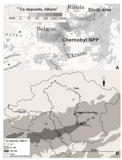
Figure 2.
(A) Location of study area within Chernobyl-affected area [92]; (B) radioactive contamination along Upa River.
We conducted the sediment budget studies for a period of over three decades in the five small catchments in the central and southern parts of the Plava River basin (Figure 3, Table 1). Our initial purpose was to evaluate the sediment and sediment-associated 137Cs redistribution during the first decade after the Chernobyl disaster.
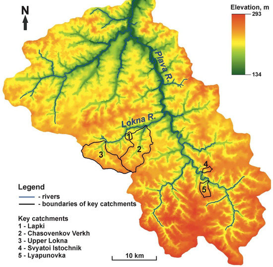
Figure 3.
Locations of key catchments in Plava River basin.

Table 1.
Morphometric characteristics of studied key catchments in Plava River basin.
We later studied the floodplain sections of the rivers of the Upa basin, including the Lokna, Plava, and Upa Rivers. The series of soil sampling sites established to determine the vertical distribution of the 137Cs isotopes at different levels of the floodplains made it possible to obtain information on the mean annual sedimentation rates and radionuclide depositions during flooding. In terms of the sediment yield from the upper reaches of the Upa River trapped in the Schekino Reservoir, we collected a few cores of bottom sediments from the ice to evaluate the rates and volumes of the deposition over the post-Chernobyl period (Figure 4).
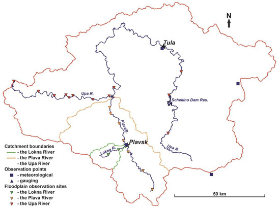
Figure 4.
Locations of observation sites on floodplains of Lokna, Plava, and Upa Rivers and Schekino Reservoir.
4. Methods
We determined the set of methods used for the different parts of the Upa River basin by its position in the hierarchical structure of the fluvial network (Figure 5).
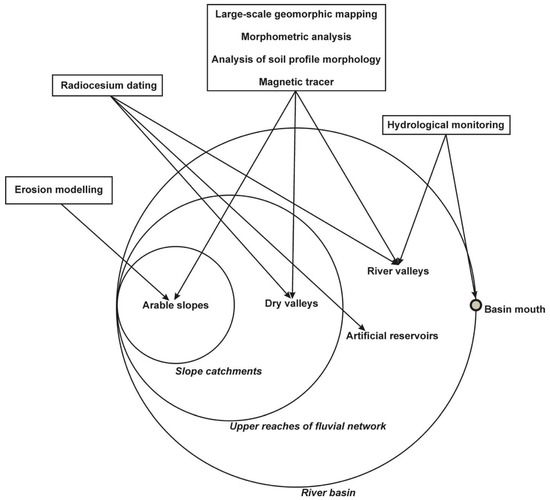
Figure 5.
Methods applied in framework of studies within Upa River basin.
4.1. Large-Scale Geomorphological Mapping
A large-scale survey of the studied areas allows for solving several specific issues necessary for carrying out a sediment budget study. First, we used the geomorphological map as a basis for the creation of a sampling strategy. The mapping of the geomorphic and land use boundaries allowed us to distinguish the area of each morphological unit. Furthermore, we ranked them according to the intensities of the observed erosion/deposition processes [93]. The maps allowed us to highlight the structural connectivity of the catchments, and to preliminarily identify the potential pathways for the sediment transport during erosion events. Finally, we applied the information on the areas of the individual morphological units in combination with the assessment of the erosion/deposition rates in each unit to the estimation of the total erosion and accumulation volumes [94]. We conducted the detection and registration of the boundaries between the geomorphic units and the exact values of the elevation by using GPS receivers and high-precision geodetic surveys during the field works.
We conducted the morphometric analyses with two goals. We used the results of the analyses to justify the selection of the key catchments and observation sites and to extrapolate the obtained results over areas not covered by the instrumental field studies within the Plava River basin [95,96]. In addition, the application of DEM models enabled us to assess the hydrological connectivity of the upper reaches of the Upa River [97], as well as the proportion of the material mobilized on the slopes of the catchment that reaches the river channels [98].
4.2. Soil Truncation Method
We used the truncation method to assess the soil losses on the cultivated slopes over the entire period of cultivation [99]. We determined the degree of the agricultural transformation of the soil profile based on its comparison with undisturbed analogues, in which the original thicknesses of the studied soil horizons have been preserved [100,101]. Considering the relatively low accuracy of identifying the boundaries between soil horizons, we can apply this method when the rate of erosion/accumulation exceeds the intensity and spatial unevenness of the soil formation process. The complexity of the pattern of the soil horizon distributions with relief parameters established for the chernozems [102] requires special studies to substantiate the application of this method [103].
4.3. Modelling of Soil Erosion
Mathematical modelling is one of the most common and labour-saving methods for the estimation of erosion and sedimentation (if the corresponding function is included in the model). In a series of studies carried out on different key catchments, the researchers used several models either individually [76] or in combination with each other [104]. In particular, they used an empirical mathematical model (EMM), which combines two modules for estimating sediment flows of different origins. To estimate the losses during rainfall, the researchers used a version of the universal soil loss equation (USLE) modified for the conditions of Russia [105], and in the case of calculations for the Upper Upa, they used the revised soil loss equation (RUSLE) [106]. The authors of [107] used a modified version of the model developed at the State Hydrological Institute to determine the soil losses during snowmelt. The authors of [108,109] used the LandSoil model, which considers the intrabasin sediment accumulation, and which is an improved modification of the STREAM (sealing and transfer by runoff and erosion related to agricultural management) model, as the model also includes a block for calculating the rates of the mechanical soil erosion (tillage erosion) [110,111].
4.4. Radiocesium Studies
The use of 137Cs as a tracer has substantially expanded the methodological possibilities of erosion and sedimentation studies. We can assess the sedimentation rate in the case of an undisturbed deposition area based on the depth of the layer with the maximum content of 137Cs (“peak”). We can conduct depth incremental sampling from the side of the soil section with the minimum amount of soil mechanical disturbance. We can conduct sampling from a fixed area (usually 15 × 15 cm) to a 2–3 cm depth. This sampling method minimizes the errors that occur when taking samples with a special sampler and then separating them into layers in the laboratory. We took the bulk samples on the arable lands with a metal sampler with an inner diameter of 6 cm to a depth of 30 cm. We used special samplers for the bottom sediments in the subaquatic conditions [112,113].
We can assess the erosion and accumulation rates on cultivated slopes using mathematical conversion models, which we can use to convert the relative changes in 137Cs deposits into soil loss or aggradation rates [114]. One of the most widely used is the proportional model [115]:
where Y is the erosion/accumulation rate (t ha−1 year−1); B is the soil bulk density (kg m−3); d is the ploughing depth (m); X is the relative decrease/increase in the 137Cs deposits (%); and T is the time after the fallout (years).
Y = (10 × B × d × X)/(100 × T),
Under the conditions of Chernobyl pollution, these models have several substantial limitations that are associated with the high variability of the atmospheric precipitation, which should be considered during the sampling and interpretation of the results [69].
4.5. Magnetic Tracer Method
The active use of coal as a fuel during the growth of industrial production and the development of railway transportation led to the intense emissions of their combustion products into the environment [116], which we can now use as chronological markers for dating sediments [117]. The method is based on the assumption that the mass of the magnetic tracer redistributed as a result of erosion is directly proportional to the mass of the redistributed soil material. Researchers found a clear reduction in the contents of magnetic particles in the eroded soils of cultivated slopes in comparison with the soils of undisturbed slopes, where they did not observe any runoff [118]. The temporal coverage of the magnetic tracer method in the basin of the Upa River is about 150 years old; however, it is strongly limited by the proximity to the locations of the railways that were operating at the time. The joint use of the magnetic tracer method together with the radiocesium technique is a good approach to assessing the erosion and accumulation rates for the different time windows [119,120,121].
4.6. Mass Balance Estimation of Particulate 137Cs Transfer for Post-Chernobyl Period
We used two approaches based on two different assumptions in the assessment of the total amount of sediment-associated 137Cs transported from the cultivated slopes to the watercourses.
We based the first variant of the calculation on the assumption that the redistribution of the particulate 137Cs mobilized by erosion processes occurs in a similar manner to the distribution of the various components of the sediment budget, which we independently assessed. We can use the following equation to express this approach:
where Q is the total mass of the river sediments (kg); W is the intrabasin sedimentation (kg); PQ is the transferred particulate 137Cs deposits (Bq); and PW is the particulate 137Cs deposits re-deposited within the basin (Bq).
Q/W = PQ/PW,
The second option is to multiply the mass of the material transported in the form of the sediment yield by the mean value of the concentration activity of the 137Cs in the sediments:
where P is the transferred 137Cs deposits (Bq); Q is the mass of the sediments in the river sediment yield (kg); and c is the mean activity concentration of the 137Cs in the transported sediments (Bq kg−1).
P = Q × c,
Considering the lack of monitoring data, the determination of the mean value of the 137Cs concentration activity over the post-Chernobyl period is difficult. This value is supposed to be of high spatial and temporal variability. First, the 137Cs-specific activity depends on the level of Chernobyl contamination, which, immediately after the fallout, was fixed on the soil particles of the surface soil layer. Then, the 137Cs was mixed and relatively evenly distributed within the upper 30 cm layer due to the deep ploughing of the arable lands [122]. The removal of the soil particles by water and tillage erosion led to the involvement of relatively clean soil particles from the deeper layers of the soil. Consequently, the 137Cs concentration in the mobilized sediments decreased. According to observations made on the rivers of the East European Plain in the first years after the accident [123], there was a sharp drop in the 137Cs concentration in the water runoff in the first 3 years after the accident, which was associated with both deep ploughing and the full removal of the 137Cs from the different surfaces within the settlements (roofs of houses, asphalt, grader roads, etc.). According to 137Cs vertical distribution studies on the reservoir bottom sediments [124,125], the decreasing 137Cs concentration trend in the direction of the upper layers of the bottom sediment is subjected to substantial annual fluctuations. However, because of the lack of monitoring observations, the sediments most closely associated with the formation of the river sediment yield are the only source of this kind of information. In the given study, we used the deposits of the low floodplain of the Plava River and the bottom sediments of the Schekino Reservoir to evaluate the mean value of the concentration activity of the 137Cs in the sediments transported by the river.
5. Changes in Some Erosion Factors in Upa River Basin over the Last Decades
The period of the intensive agricultural use of the Upa River basin was about 250–300 years. During the period from the second half of the 19th century to the middle of the 20th century, there was a reduction in the stream network density (SND) and the extinction of some of the permanent watercourses. Two hypotheses have been proposed to explain this process: (1) the increase in the sediment supply from the increased area of cultivated lands affected by erosion [126]; (2) climate change. The first explanation is more likely. The SND had a stronger reduction in the Plava River basin, which has a much higher share of cultivated areas than the entire Upa River basin. The smaller reduction in the SND of the Upa River basin in comparison with the Plava River was due to the large amount of forested area, where no substantial siltation or subsequent aggradation occurs (Table 2).
Table 2.
Changes in SNDs of Plava and Upa River basins (Adapted with permission from Ref. [68]. 2006, CATENA).
In the Plava River basin, the SNDs during the second half of the 20th century and the beginning of the 21st century were generally stable (Table 3). In the 2000s, the SND slightly increased.
Table 3.
SNDs in Plava River basin over different periods.
The major contribution to the sediment yield of the Plava and Upa Rivers is made by erosion during the snowmelt in the springtime. One of the most important factors is the condition of the soil cover at the time of the snowmelt. The comparatively warm transition from autumn to winter, with a stable snow cover, leads to the absence or insignificant depth of freezing, which causes the upper soil horizons to retain a high infiltration capacity. As a result, when the snow melts, most of the water is directly filtered into the ground, without erosion. This trend has been typical for the forest-steppe zone of the East European Plain over the last decades. As a result, we expect the contribution of the erosion on the arable slopes to the sediment yield to decrease [127].
The reduction in the surface runoff during the spring snowmelt also leads to a decrease in the duration (Figure 6) of the floods, which, in turn, contributes to a decrease in the intensity of the channel erosion [81].
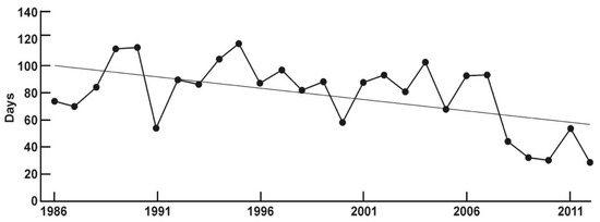
Figure 6.
Duration of floods on Upa River (Orlovo gauging observation point). Straight sloping line indicates change trend [81].
Runoff-forming rainfall, which potentially leads to washouts and occurs during the warm season, is subject to much greater fluctuations, according to the weather station in Plavsk for the period of 1986–2018. The total precipitation from year to year could differ by more than two times (Figure 7A). At the same time, more than half of the rainfall falls on the 12 wettest days (Figure 7B), when washouts are most likely to form because of the heavy rains.
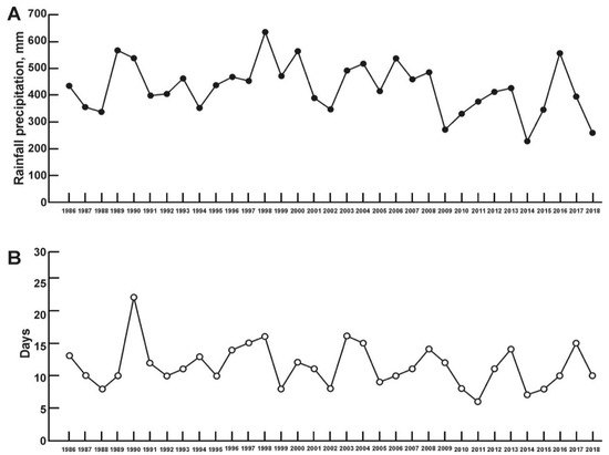
Figure 7.
(A) Precipitation layer of warm seasons for 1986–2018; (B) number of wettest days during which more than 50% of the rainfall fell, according to data from Plavsk weather station.
In the Upa River basin, the erosion caused by rainfall most likely occurs in the months with the sparsest or no vegetation cover on the arable land, which are the periods after the ploughing in late spring (May) and the harvesting of the main crop in late summer and early autumn (August–September). From 1986 to 2018, the maximum number of days when the amount of rainfall was sufficient to form runoff substantially varied. May of 1998, 2010, 2011, 2014, and 2016 was the most probable time for storm washouts. Extremely heavy rainfall (>50 mm) was recorded only once, in 2010 (Figure 8A). In the summer–autumn period, the years with the most probable erosion on the arable lands were 2002–2004, 2006–2008, and 2011. Showers were observed only three times: in 2006, 2008, and 2011 (Figure 8B).
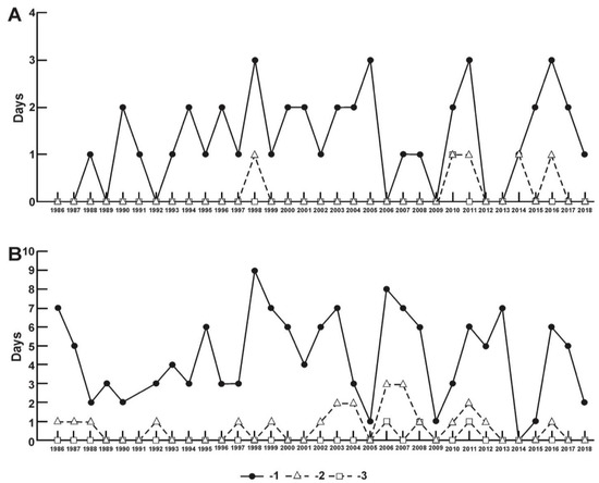
Figure 8.
Number of days with rainfall of different intensities in (A) May and (B) August–September for 1986–2018: 1: >10 mm; 2: >30 mm; 3: >50 mm.
The rarity and spatial localization of extreme storms indicate that their contribution to the sediment yield of rivers is small, especially because most of the products of storm washouts are redeposited along the transportation routes from arable slopes to permanent watercourses [128,129]. The economic crisis of the early 1990s led to a substantial reduction in the area of arable lands, and despite the recovery of economic growth, their share continued to gradually decline until the middle of the second decade of the 21st century (Table 4). Since 2018, there have been serious changes in the structure of the land use and composition of the crop rotations due to the transfer of a portion of the lands to large agricultural enterprises. The boundaries of the fields are changing, the shares of vegetables and soybeans in the crop rotations are increasing, and the production of grain crops and potatoes is decreasing.
Table 4.
Proportions of arable land from total basin area of Plava River and upper reaches of Upa River (catchment area of Schekino Reservoir) in 1985, 2000, and 2015.
6. Intrabasin Redistribution of Sediments and Particulate 137Cs in Upa River Basin
6.1. Transformation of Radioactive Contamination on Arable Slopes
The redistribution of the sediments and Chernobyl 137Cs on the slopes was the main direction of the research carried out in the first decades after the accident because it enabled us to identify the primary transformation of the contamination to assess the sediment budgets on the slopes and slope sub-catchments over the post-Chernobyl period. According to studies conducted in the mid-1990s, 11 years after the Chernobyl fallout is too short a time window for substantial 137Cs losses from the cultivated slopes due to soil erosion. An increase in the 137Cs deposits only occurred in the local sediment sinks (up to 1.5–2 times on the bottoms of the uncultivated parts of hollows) [47]. The hollow systems on the cultivated slopes are the most important pathway for the transport of sediments beyond the cultivated fields. The boundaries “cultivated slope/valleys’ side” and “valleys’ sides/dry valleys’ bottoms” are the zones in which a substantial portion of the mobilized sediments are redeposited [48].
According to the combined use of the radiocesium and magnetic tracer methods, there was a clear trend towards decreasing erosion rates for the post-Chernobyl period on the cultivated slopes of the forest-steppe zone compared with the 150 years of active ploughing. The main reasons for the decline were the decreases in the intensity of the snowmelt runoff on the slopes in the spring and the proportion of row crops in the crop rotation [130]. Moreover, according to the magnetic tracer, the intraslope sediment deposition depends on a complex of local factors and can take place on any part of the slope [131]. The delivery of sediments and particulate 137Cs beyond arable slopes is determined not only by the configuration of the slope, but also, to a large extent, by the anthropogenic relief, including the plough ramparts along the field boundaries. Plough ramparts (so-called “napash’”) are an important barrier for both sediment and sediment-associated 137Cs [80].
The loss of material on the slopes led to a consistent reduction in the 137Cs deposits. To estimate the reduction in the deposits, we used the proportional conversion model [115] in the reverse order. We independently estimated the erosion rates, and we converted them into the relative reduction in the 137Cs deposits [132]:
where X is the relative reduction in the 137Cs deposits (%); Y is the erosion/accumulation rate (t ha−1 year−1); T is the number of years; B is the soil density (bulk density) (kg m−3); and d is the ploughing depth (m).
X = (10 × Y × T)/(B × d),
Given the mean rate of erosion of 6.4 t ha−1 year−1 on the arable slopes of the Plava River basin [104] and excluding the segments of the basin that are limited by artificial sinks [133], the maximum mass of the mobilized sediments was no more than 16 × 106 t over 1986–2012. This value might be overestimated because it contains the results of the universal erosion equation (USLE) calculations, which do not consider the intraslope accumulation.
The proportion of sediments that entered the valley bottom network was about 61.6%. We based this estimation on the values of the sediment delivery ratio (SDR) for slopes of different morphologies, which we obtained after the generalization of several observations [134] and the morphometric analysis of the relief of the Plava River basin [133]. A total of 38.4% of all the mobilized sediments were redeposited on the slopes, which amounted to 6.1 × 10⁶ t.
Using the available large-scale maps of the radioactive contamination and the results of our survey [135], we calculated the net loss of the 137Cs deposits from the cultivated slopes. In just 26 years after the accident, the total 137Cs deposit losses caused by erosion were about 12.2 × 10¹² Bq (recalculated for 1986). Considering the overestimation of the erosion rates, the average annual 137Cs deposit losses from the cultivated slopes amounted to no more than 0.2% of the total 137Cs fallout. According to the results of the first experimental work on the study of the reduction in the 137Cs deposits on the cultivated slopes of the Chernobyl-affected zone, with the use of artificial sprinkling, the reduction in the deposits due to erosion does not exceed a few percent. The slope runoff for the year (1995–1996) led to a 137Cs deposit reduction of only 0.07% [136].
6.2. Sediment and Particulate 137Cs Redistribution along Pathways from Catchment Area to Watercourses
Dry valleys (“balka”) occupy the main extent of the fluvial network of the Upa River basin. A major portion of sediment that is transferred by the temporary streams from the arable slopes is redeposited on the dry valley bottoms. The intensity of the sediment redeposition primarily depends on the slope of the valley bottom [137]. According to the assessment made for the Plava River for the period 1986–2009, about 60% of the sediments that had washed away from the cultivated slopes did not leave the catchments of the first–third Hortonian orders [104]. The proportion of sediment carried outside the catchments of the valleys of the fourth Hortonian order, as a rule, does not exceed 10% [74,138,139]. The average “slope-river valley” SDR for the entire basin of the Plava River is 0.27, excluding segments of the basin cut off by artificial reservoirs. The main source of the material inflow into the valleys of the Plava River and its tributaries is the catchments of small valleys of 1–2 orders that flow directly into them. The bottoms of the dry valleys of the 3–4-order catchments are the main sediment sinks [104].
The sediments that accumulate on the bottoms of dry valleys, in the artificial reservoirs that are constructed on them, and on river floodplains, which are discussed below, are an important source of information for studying the dynamics of the erosion and accumulation processes over the period dated with 137Cs from the global and Chernobyl fallouts [140]. The increase in the 137Cs deposits in these sediment sinks is so intense that it can compensate for the losses from radioactive decay. However, layers with a high concentration of 137Cs are overlapped by sediments with much lower concentrations eroded from arable land [141]. The total accumulation in the dry valley bottoms of the Plava River basin over the post-Chernobyl period amounted to 4.3 × 10⁶–6.1 × 10⁶ t.
6.3. Floodplain Accumulation of Sediment and 137Cs
According to studies on the floodplain complexes of the Lokna, Plava, and Upa Rivers, there is a high spatial unevenness in the accumulation of sediments and radionuclides. Moreover, there is a substantial difference between the sedimentation rates at the different levels of the Lokna River floodplain. On the lower floodplain, the sedimentation rate is 0.3–1.1 cm year−1. This growth is high enough to overcome the 137Cs losses due to radioactive decay. On the middle floodplain, the accumulation for the post-Chernobyl period is low due to the decreasing spring flood levels associated with the reduction to almost zero in the surface runoff from the slopes during snowmelt [142].
The Plava River floodplain, where the accumulation rates on the low floodplain change in the range of 0.7–1.4 cm year−1, produced similar results [143]. We primarily explored the floodplain sedimentation on the Upa River valley bottom in the middle and lower reaches starting from the mouth of the Plava River. We evaluated two additional sections upstream and downstream of the Schekino Reservoir (see Figure 4). The low level of the floodplains is discontinuous and represented by rather narrow sections. For the period 1986–2014, the sedimentation rates on the low level of the floodplain reached 1.5–2.7 cm year−1. Thus, there was a consistent increase in the sediment accumulation rate as the water discharge increased along the Upa River, which was most likely associated with the increase in the duration of the flooding of the low floodplain. A major portion of the particulate 137Cs, which entered the Upa River channel, was delivered to the Oka River.
The downtrend surface runoff during snowmelt, especially after 2007 (see Figure 3), resulted in a decrease in the level and duration of the flooding in spring, and a reduction in the contribution of the hillslope erosion to the sediment yield in the Upa River basin. Consequently, the impact of the contaminated sediment transported by the Plava River on the level of the contamination of the Upa River declined [50].
The floodplain complex is primarily formed due to the action of fluvial processes. The lateral supply of the material from the sides of the valleys only plays a substantial role during ploughing. Due to the large area of the high floodplain and small amount of information on the accumulation rates, a direct reliable assessment of the accumulation is complicated. The main accumulative component of the sediment balance on the surface of the high floodplain under the rare high flood conditions and dense vegetation cover, which traps the sediments, is the erosion on the hillslopes directly adjacent to the sides of the river valleys [144].
The total transfer to the river valleys of the Plava River basin for the period 1986–2012 was 3.8 × 10⁶–5.6 × 10⁶ t, of which 1.6 × 10⁶–1.7 × 10⁶ t accumulated on the river floodplains. We estimated the sediment yield by the residual principle in the range of 2.1 × 10⁶–4 × 10⁶ t.
6.4. Sediment Budget of Sub-Basins of Upa River Basin: Plava River and Upper Reaches of Upa River
By summarizing the results of the estimations represented above, we could assess the sediment budget of the entire Plava River. We present the results in graphical form in Figure 9. The accuracy and reliability of the obtained results are affected by the totality of the errors and limitations of all the particular applied methods. However, we can consider these results to be the most detailed and factually substantiated for the river basins of Central Russia, which have been subjected to intense radioactive contamination.
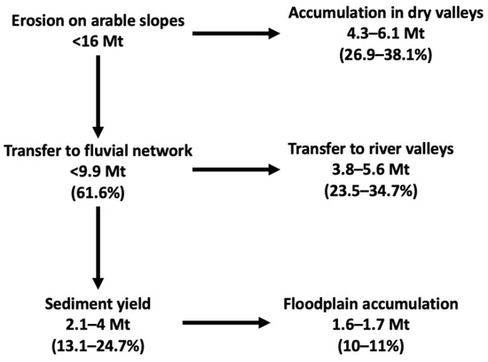
Figure 9.
Preliminary sediment budget of Plava River for 1986–2012.
In comparison with the Plava River, the corresponding values for the upper reaches of the Upa River are much lower. According to the mathematical modelling of the erosion and SDR distribution over the catchment, during 1986–2018, 4.6 × 10⁶–4.8 × 10⁶ t of sediment was eroded from the cultivated slopes, and 0.44 × 10⁶–0.47 × 10⁶ was delivered to the permanent streams [66]. It is likely that we underestimated the systematic sediment delivery to the rivers. Currently, the Schekino Reservoir is a large sink for the sediments and particulate 137Cs delivered from the upper reaches of the Upa River. The observed decrease in the concentration activity towards the surface of the bottom sediments clearly demonstrates the general trend towards a decrease in the 137Cs content in the river sediment yield for the post-Chernobyl period [124,125,145]. The overlapping of the most active strata of sediments, with less polluted sediments under modern conditions, serves as a factor in increasing environmental safety [145]. According to the analysis of the vertical distribution of the 137Cs in the bottom sediments sampled in 2018–2019 [125], sediment accumulation during the post-Chernobyl period only occurred in the flooded channel of the Upa River, which occupies a relatively small part of the reservoir bottom area (Figure 10A). When assessing the total accumulation within the boundaries of the water area, we divided the riverbed into sections depending on the location of the selected cores, which we took as characteristic of the sections (Figure 10B).
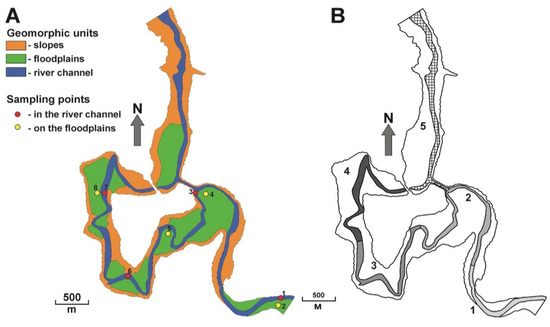
Figure 10.
(A) Geomorphic structure of Schekino Reservoir bottom with locations of sampling points; (B) locations of sections (marked with numbers 1–5) arranged for calculations for river channel to assess accumulation for post-Chernobyl period.
We calculated the accumulation using the following formula:
where WRes is the total accumulation in the reservoir (t), and Wn is the accumulation within the boundaries of the individual sections (t). We calculated the accumulation within n selected sections with the following formula:
where Hn is the mass depth of the “Chernobyl peak” in the sediment column (kg m−2), and Sn is the area of the corresponding section (m2).
WRes = W1 + … + Wn,
Wn = Hn × Sn,
We present the results in Table 5. The total mass of the accumulated sediments was more than 0.37 × 10⁶ t (Table 5). Considering that we only determined the volume of the sediments accumulated since 1986 for the upper larger part of the reservoir, and a part of suspended sediments can still cross the dam, the resulting estimate should be considered an a priori underestimation.
Table 5.
Mass depth of “Chernobyl Peak” and areas and masses of sediments in selected sections of the flooded channel of Schekino Reservoir for the post-Chernobyl period.
According to the estimates made using the RUSLE model, the total washout from the catchment area for the period under review amounted to 4.64 × 10⁶–4.78 × 10⁶ t, of which river valleys reached 0.44 × 10⁶–0.47 × 10⁶ tons, or less than 10% [97].
According to the analysis of the particle size distribution of the longest of the sampled sediment cores (№6) (see Figure 10A and Table 5), there was a trend towards a smooth increase in the proportion of coarser mechanical fractions (Figure 11A) and, accordingly, an increase in the median size (d50) of the bottom sediment particles to the surface of the sediment layer (Figure 11B). We expected this distribution considering the decrease in the supply of material enriched with clay fractions from the arable slopes and the increase in the proportion of coarser material formed due to the bank erosion and incision of the river channels.
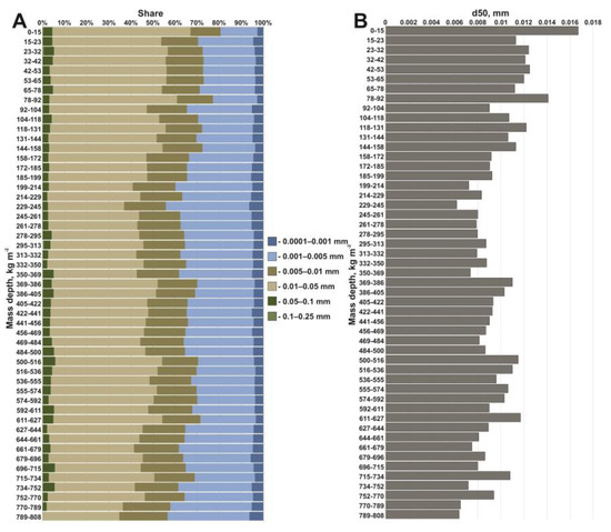
Figure 11.
Grain-size composition of bottom sediments accumulated after 1986: (A) proportion of particles of different sizes; (B) median particle sizes (d50) (according to data from Core 6).
Based on the obtained balance estimates, we calculated the indicators of the sediment yield modulus for the Plava and upper reaches of the Upa River basins. The obtained values are quite close to the established values based on the monitoring studies at the gauging stations of the Hydrometeorological Service, located on the rivers of the Oka River basin, with a catchment area of the same order (Table 6).
Table 6.
Calculated sediment yield for Plava and upper reaches of Upa River basins in comparison with corresponding values of other rivers of forest steppe and south of forest zones in Oka River basin, which we obtained based on long-term observations of water and suspended sediment discharge (based on Golosov, 1989 [146]).
Considering the overestimation of the erosion rates within the Plava River basin, we should assume that the SDR value of the entire basin is also systematically overestimated. However, the results obtained for both studied catchments fit well into the range of estimates made for the rivers of the East European Plain with the close areas of their catchments (Table 7).
Table 7.
Comparison of SDR values of Plava River and upper reaches of Upa with river basins of Oka River system [147].
6.5. Particulate 137Cs Budget of Plava River and Upper Reaches of Upa River
We obtained the results based on the assumed equality of the ratios of the sediment budget components (Figure 10) and mobilized deposits of particulate 137Cs (Equation (2)) in the Upa River basin for the post-Chernobyl period (Table 8).
Table 8.
Distribution of 137Cs deposits between different sediment budget components of Plava River basin in 1986–2012.
According to the estimates presented in Table 8, for the period 1986–2012, from 0.41 to 1% of the initial Chernobyl fallout of 137Cs was carried out outside the basin of the Plava River in particulate form. Considering the likely overestimation of the hillslope erosion, the total delivery of the particulate radionuclides to the receiving watercourse (the Upa River) did not exceed 0.83% of the initial fallout.
An alternative approach is to use Equation (3), from which we obtained the results presented in Table 9. We considered two values of the estimated sediment yield of the Plava River. The first option has already been described above and presented in Figure 10. Considering the landscape and geomorphological similarity of the catchments, in the second option, we assumed the proximity of the value of the sediment yield of the Plava River to the corresponding value of the upper reaches of the Upa River. We estimated the mean 137Cs concentration activity in the sediment runoff of the Plava River from samples taken at the low floodplains [143,144]. We estimated the sediment yield and concentration activity in the sediments for the upper reaches of the Upa River based on the results of a study on the bottom sediments of the Schekino Reservoir [125].
Table 9.
Evaluation of particulate 137Cs deposits transferred with sediment yield beyond Plava River and Upper Reaches of Upa River.
In conclusion, all the estimations show that less than 1.5% of the Chernobyl fallout 137Cs left the observed catchment over almost three decades. Given the underestimation of the accumulation in the Schekino Reservoir, the total deposits of the particulate 137Cs in the sediment yield of the Plava River and upper reaches of the Upa River (in the absence of the Schekino Reservoir) were more than 0.1% of the initial fallout. We expected such a low value due to the current rates of the erosion processes on the arable land and the peculiarities of the redistribution of the sediments along their transfer routes from the arable slopes to the permanent watercourses, and due to the reduction in arable land after 1991.
7. Research Prospects
The perspectives of the mass-balance studies on the sediment and particulate 137Cs redistribution in the river catchment present several directions. The first one includes improving the existing set of methods. As was mentioned earlier, the disadvantages of the methods used are associated either with the inaccuracy of the quantitative results or with the incompleteness of the data obtained within the study area. Systematic distortions of the assessment are the most characteristic of the mathematical modelling of the erosion and accumulation processes. We discuss the overestimation of the erosion rates on the cultivated slopes when using the USLE/RUSLE models above. At the moment, the models are constantly being improved; however, they require verification through their combined use with the radiocesium method, remote sensing, and analyses of available meteorological data, especially for single extreme erosion events.
The regular depth incremental sampling with the subsequent transportation and laboratory processing of the samples requires considerable time, which makes the process for obtaining the final estimations rather long. According to the work experience in the Upa basin, several years pass between field studies and the publication of the results. This time lag makes it difficult to study the intensive transformation of fluvial systems. A high level of radioactive contamination provides the opportunity to make a rapid determination of the relative distribution of the 137Cs deposits along the soil profile and the allocation of the “Chernobyl Peak”, and it makes it possible to assess the thickness of the accumulated strata and adjust the sampling point network if needed.
According to the study carried out on the floodplain of the Lokna River [148], field spectrometry may substantially accelerate the obtainment of the data. However, a complete rejection of the depth increment is not possible for two reasons: (1) it is still necessary to determine the absolute values of the 137Cs concentration activity and deposits, which is achievable only via the examination of samples with fixed geometries; (2) the accuracy of determining the vertical distribution of 137Cs is also substantially higher in the case of the laboratory analyses of incremental samples. Thus, in situ measurements can only complement the existing methods and justify the extrapolation of laboratory-obtained data.
Conducting studies on the catchments of artificial reservoirs, where we can almost completely assess the sediment budget, is promising because almost all the sediment yield is trapped in the mouths of these catchments. The sediment budgets for time intervals that extend beyond the post-Chernobyl period using methods for assessing the intensity of the erosion-accumulative processes of various time windows are of particular interest. These evolutions make it possible to determine the effectiveness of the applied soil protection measures [149,150]. At the same time, budget studies are of substantial ecological importance because the transfer of 137Cs within the contaminated catchments is arguably analogous to the redistribution of other pollutants associated with sediments.
Intensive climatic fluctuations and anthropogenic impacts are actualizing monitoring studies on small river basins subjected to radioactive contamination. The lack of monitoring data in previous years can be partially compensated for by studies on the vertical distribution of the radionuclides in reservoirs [124,125,148]. The duration of the post-Chernobyl period allows us to study the change dynamics through repeated field surveys of the catchments combined with observations made decades ago.
8. Main Messages
- Under the conditions of the reduction in the surface runoff from the slopes during the snowmelt and the relatively stable area of arable land over the last two decades, the intensity of the transfer of the particulate 137Cs from the arable slopes has decreased. From a quantitative perspective, the process of the sediment fluxes overcoming the lower boundaries of arable land remains poorly studied. In these relatively compact zones, fundamental changes in the flow conditions occur. The functional connectivity of the catchments with high proportions of arable lands is critical. We can use technological solutions that make it possible to obtain statistically reliable amounts of information within relatively short time intervals to solve this problem. Such methods include complex radiocesium studies, such as in situ measurements and repeated high-precision geodetic surveys with the involvement of UAVs.
- Dry valley bottoms are the main material sinks for sediment and sediment-associated 137Cs that have eroded from cultivated slopes. The creation of new artificial reservoirs in the bottoms of dry valleys isolated in a substantial portion of the river basins has led to a considerable reduction in the river sediment yield.
- The recent reduction in the spring flood levels of the regional rivers promotes an increase in the disconnectivity between the streams and catchment slopes. Under conditions of high anthropogenic loads, the sediment yield is expected to take a minor portion of the sediment budget. However, this is the main mechanism of radionuclide delivery outside the zone of intense fallout. The lateral migration of the particulate 137Cs slightly changed the spatial pattern of the contamination. Within some of the sediment traps located along the 137Cs transport path from the slopes to the permanent streams, substantial changes in the deposits occurred. At the same time, the accumulation of polluted sediments in the artificial reservoirs serves as a mechanism for the formation of new environmental risks when pollutants are released into the river systems, which requires consideration when making water management decisions.
- According to the research experience in the areas of Chernobyl contamination, the analysis of the vertical distribution of the radionuclides in the accumulative strata makes it possible to reconstruct the transformation of the sediment budget and the behaviour of the pollutants in the fluvial systems. This source of information becomes particularly important under the condition of incomplete or no hydrological monitoring observations. Activation of the redistribution of the material accumulated on the bottoms by the bottom gullies is a probable scenario under climate change.
Funding
This research was conducted within framework of the project funded Russian Scientific Foundation number 21-77-00050 (evaluation of sediment and particulate 137Cs budgets) and within State Task 121051100166-4 “Hydrology, morphodynamics and geoecology of erosion-channel systems” (comparative review of works dedicated to Chernobyl and Fukushima contamination).
Conflicts of Interest
The authors declare no conflict of interest.
References
- Dietrich, W.E.; Dunne, T. Sediment budget for a small catchment in mountainous terrain. Zeits. Geomorphol. Supp. 1978, 29, 191–206. [Google Scholar]
- Walling, D.E. The sediment delivery problem. J. Hydrol. 1983, 65, 209–237. [Google Scholar] [CrossRef]
- Slaymaker, O. The sediment budget as conceptual framework and management tool. In The Interactions between Sediments and Water; Springer: Dordrecht, The Netherlands, 2003; pp. 71–82. [Google Scholar]
- Einsele, G. Sedimentary Basins: Evolution, Facies, and Sediment Budget; Springer: Berlin/Heidelberg, Germany, 2000. [Google Scholar] [CrossRef]
- Hinderer, M. From gullies to mountain belts: A review of sediment budgets at various scales. Sedim. Geol. 2012, 280, 21–59. [Google Scholar] [CrossRef]
- Reid, L.M.; Dunne, T. Rapid Evaluation of Sediment Budgets; Catena: Reiskirchen, Germany, 1996; Volume 29, 164p. [Google Scholar]
- Trimble, S.W. Decreased rates of alluvial sediment storage in the Coon Creek Basin, Wisconsin, 1975–1993. Science 1999, 285, 1244–1246. [Google Scholar] [CrossRef]
- Nyssen, J.; Poesen, J.; Moeyersons, J.; Haile, M.; Deckers, J. Dynamics of soil erosion rates and controlling factors in the Northern Ethiopian Highlands–towards a sediment budget. Earth Surf. Proc Landf. 2008, 33, 695–711. [Google Scholar] [CrossRef]
- Wang, Z.Y.; Li, Y.; He, Y. Sediment budget of the Yangtze River. Water Resour. Res. 2007, 43, WR005012. [Google Scholar] [CrossRef]
- De Moor, J.J.W.; Verstraeten, G. Alluvial and colluvial sediment storage in the Geul River catchment (The Netherlands)—Combining field and modelling data to construct a Late Holocene sediment budget. Geomorphology 2008, 95, 487–503. [Google Scholar] [CrossRef]
- Notebaert, B.; Verstraeten, G.; Rommens, T.; Vanmontfort, B.; Govers, G.; Poesen, J. Establishing a Holocene sediment budget for the river Dijle. Catena 2009, 77, 150–163. [Google Scholar] [CrossRef]
- Minella, J.P.; Walling, D.E.; Merten, G.H. Establishing a sediment budget for a small agricultural catchment in southern Brazil, to support the development of effective sediment management strategies. J. Hydrol. 2014, 519, 2189–2201. [Google Scholar] [CrossRef]
- Kondolf, G.M.; Schmitt, R.J.; Carling, P.; Darby, S.; Arias, M.; Bizzi, S.; Castelletti, A.; Cochrane, T.A.; Gibson, S.; Kummu, M.; et al. Changing sediment budget of the Mekong: Cumulative threats and management strategies for a large river basin. Sci. Total Environ. 2018, 625, 114–134. [Google Scholar] [CrossRef]
- Boardman, J.; Poesen, J. (Eds.) Soil Erosion in Europe; John Wiley & Sons: Chichester, UK, 2007; 854p. [Google Scholar]
- Chalise, D.; Kumar, L.; Kristiansen, P. Land degradation by soil erosion in Nepal: A review. Soil Syst. 2019, 3, 12. [Google Scholar] [CrossRef]
- García-Ruiz, J.M. The effects of land uses on soil erosion in Spain: A review. Catena 2010, 81, 1–11. [Google Scholar] [CrossRef]
- Holz, D.J.; Williard, K.W.; Edwards, P.J.; Schoonover, J.E. Soil erosion in humid regions: A review. J. Contemp. Water Res. Educ. 2015, 154, 48–59. [Google Scholar] [CrossRef]
- Nearing, M.A.; Xie, Y.; Liu, B.; Ye, Y. Natural and anthropogenic rates of soil erosion. Intern. Soil Water Conserv. Res. 2017, 5, 77–84. [Google Scholar] [CrossRef]
- Vanmaercke, M.; Panagos, P.; Vanwalleghem, T.; Hayas, A.; Foerster, S.; Borrelli, P.; Poesen, J. Measuring, modelling and managing gully erosion at large scales: A state of the art. Earth-Sci. Rev. 2021, 218, 103637. [Google Scholar] [CrossRef]
- Wen, X.; Zhen, L. Soil erosion control practices in the Chinese Loess Plateau: A systematic review. Environ. Dev. 2020, 34, 100493. [Google Scholar] [CrossRef]
- Borrelli, P.; Alewell, C.; Alvarez, P.; Anache, J.A.A.; Baartman, J.; Ballabio, C.; Bezak, N.; Biddoccu, M.; Cerdà, A.; Chalise, D.; et al. Soil erosion modelling: A global review and statistical analysis. Sci. Total Environ. 2021, 780, 146494. [Google Scholar] [CrossRef] [PubMed]
- Castillo, C.; Gómez, J.A. A century of gully erosion research: Urgency, complexity and study approaches. Earth-Sci. Rev. 2016, 160, 300–319. [Google Scholar] [CrossRef]
- Garcia-Ruiz, J.M.; Beguería, S.; Nadal-Romero, E.; Gonzalez-Hidalgo, J.C.; Lana-Renault, N.; Sanjuán, Y. A meta-analysis of soil erosion rates across the world. Geomorph 2015, 239, 160–173. [Google Scholar] [CrossRef]
- Labrière, N.; Locatelli, B.; Laumonier, Y.; Freycon, V.; Bernoux, M. Soil erosion in the humid tropics: A systematic quantitative review. Agric. Ecosyst. Environ. 2015, 203, 127–139. [Google Scholar] [CrossRef]
- Vanmaercke, M.; Poesen, J.; Van Mele, B.; Demuzere, M.; Bruynseels, A.; Golosov, V.; Bezerra, J.F.R.; Bolysov, S.; Dvinskih, A.; Frankl, A.; et al. How fast do gully headcuts retreat? Earth-Sci. Rev. 2016, 154, 336–355. [Google Scholar] [CrossRef]
- Evrard, O.; Laceby, J.P.; Nakao, A. Effectiveness of landscape decontamination following the Fukushima nuclear accident: A review. Soil 2019, 5, 333–350. [Google Scholar] [CrossRef]
- Fu, B.; Merritt, W.S.; Croke, B.F.; Weber, T.R.; Jakeman, A.J. A review of catchment-scale water quality and erosion models and a synthesis of future prospects. Environ. Model. Soft. 2019, 114, 75–97. [Google Scholar] [CrossRef]
- Issaka, S.; Ashraf, M.A. Impact of soil erosion and degradation on water quality: A review. Geol. Ecol. Land. 2017, 1, 1–11. [Google Scholar] [CrossRef]
- Onda, Y.; Taniguchi, K.; Yoshimura, K.; Kato, H.; Takahashi, J.; Wakiyama, Y.; Coppin, F.; Smith, H. Radionuclides from the Fukushima Daiichi nuclear power plant in terrestrial systems. Nat. Rev. Earth Environ. 2020, 1, 644–660. [Google Scholar] [CrossRef]
- Shakesby, R.A. Post-wildfire soil erosion in the Mediterranean: Review and future research directions. Earth-Sci. Rev. 2011, 10, 71–100. [Google Scholar] [CrossRef]
- Eekhout, J.P.; de Vente, J. Global impact of climate change on soil erosion and potential for adaptation through soil conservation. Earth-Sci. Rev. 2022, 226, 103921. [Google Scholar] [CrossRef]
- Haregeweyn, N.; Tsunekawa, A.; Nyssen, J.; Poesen, J.; Tsubo, M.; Tsegaye Meshesha, D.; Tegegne, F. Soil erosion and conservation in Ethiopia: A review. Progr. Phys. Geogr. 2015, 39, 750–774. [Google Scholar] [CrossRef]
- Walling, D.E.; Collins, A.L. The catchment sediment budget as a management tool. Environ. Sci. Pol. 2008, 11, 136–143. [Google Scholar] [CrossRef]
- Xiong, M.; Sun, R.; Chen, L. Effects of soil conservation techniques on water erosion control: A global analysis. Sci. Total Environ. 2018, 645, 753–760. [Google Scholar] [CrossRef]
- Grygar, T.M.; Hošek, M.; Navrátil, T.; Bednárek, J.; Hönig, J.; Elznicová, J.; Pacina, J.; Rohovec, J.; Sedláček, J.; Sass, O. Lessons Learnt from the Revitalisation of Chemical Factory in Marktredwitz and River Banks Downstream: When ‘Renaturation’Can Be Harmful. Water 2022, 14, 3481. [Google Scholar] [CrossRef]
- Horowitz, A.J. A Primer on Sediment-Trace Element Chemistry; Lewis: Chelsea, MA, USA, 1991; 134p. [Google Scholar]
- Marron, D.C. Floodplain storage of mine tailings in the Belle Fourche River system: A sediment budget approach. Earth Surf. Proc. Land. 1992, 17, 675–685. [Google Scholar] [CrossRef]
- Macklin, M.G.; Hudson-Edwards, K.A.; Dawson, E.J. The significance of pollution from historic metal mining in the Pennine orefields on river sediment contaminant fluxes to the North Sea. Sci. Total Environ. 1997, 194–195, 391–397. [Google Scholar] [CrossRef]
- Macklin, M.G.; Brewer, P.A.; Hudson-Edwards, K.A.; Bird, G.; Coulthard, T.J.; Dennis, I.A.; Lechler, P.J.; Miller, J.R.; Turner, J.N. A geomorphological approach to the management of rivers contaminated by metal mining. Geomorphology 2006, 79, 423–447. [Google Scholar] [CrossRef]
- Miller, J.R. The role of fluvial geomorphic processes in the dispersal of heavy metals from mine sites. J. Geoch. Explor. 1997, 58, 101–118. [Google Scholar] [CrossRef]
- Walling, D.E.; Owens, P.N.; Carter, J.; Leeks, G.J.L.; Lewis, S.; Meharg, A.A.; Wright, J. Storage of sediment-associated nutrients and contaminants in river channel and floodplain systems. Appl. Geochem. 2003, 18, 195–220. [Google Scholar] [CrossRef]
- Byrne, P.; Wood, P.J.; Reid, I. The impairment of river systems by metal mine contamination: A review including remediation options. Crit. Rev. Env. Sci. Tech. 2012, 42, 2017–2077. [Google Scholar] [CrossRef]
- Ciszewski, D.; Grygar, T.M. A review of flood-related storage and remobilization of heavy metal pollutants in river systems. Water Air Soil Pollut. 2016, 227, 1–19. [Google Scholar] [CrossRef]
- Ivanov, M.M.; Kuzmenkova, N.V.; Garankina, E.V.; Tulyakov, E.D. The 232Th distribution in modern sediments near radioactive lovchorrite mine, the Khibiny Mountains, Kola Peninsula. J. Geoch. Explor. 2019, 200, 77–83. [Google Scholar] [CrossRef]
- Beresford, N.A.; Fesenko, S.; Konoplev, A.; Skuterud, L.; Smith, J.T.; Voigt, G. Thirty years after the Chernobyl accident: What lessons have we learnt? J. Environ. Radioact. 2016, 157, 77–89. [Google Scholar] [CrossRef]
- Golosov, V.N.; Walling, D.E.; Panin, A.V.; Stukin, E.D.; Kvasnikova, E.V.; Ivanova, N.N. The spatial variability of Chernobyl-derived 137Cs inventories in a small agricultural drainage basin in central Russia. Appl. Rad. Isotop. 1999, 51, 341–352. [Google Scholar] [CrossRef] [PubMed]
- Golosov, V.N.; Panin, A.V.; Markelov, M.V. Chernobyl 137Cs redistribution in the small basin of the Lokna river, Central Russia. Phys. Chem. Earth, Part A Sol. Earth Geod. 1999, 24, 881–885. [Google Scholar] [CrossRef]
- Panin, A.V.; Walling, D.E.; Golosov, V.N. The role of soil erosion and fluvial processes in the post-fallout redistribution of Chernobyl-derived caesium-137: A case study of the Lapki catchment, Central Russia. Geomorphology 2001, 40, 185–204. [Google Scholar] [CrossRef]
- Konoplev, A.; Golosov, V.; Laptev, G.; Nanba, K.; Onda, Y.; Takase, T.; Wakiyama, Y.; Yoshimura, K. Behavior of accidentally released radiocesium in soil–water environment: Looking at Fukushima from a Chernobyl perspective. J. Environ. Radioact. 2016, 151, 568–578. [Google Scholar] [CrossRef]
- Golosov, V.; Ivanov, M. Quantitative Assessment of Lateral Migration of the Chernobyl- Derived 137Cs in Contaminated Territories of the East European Plain. In Behavior of Radionuclides in the Environment II; Springer: Singapore, 2020; Chapter 4; pp. 196–226. [Google Scholar] [CrossRef]
- Chartin, C.; Evrard, O.; Laceby, J.P.; Onda, Y.; Ottlé, C.; Lefèvre, I.; Cerdan, O. The impact of typhoons on sediment connectivity: Lessons learnt from contaminated coastal catchments of the Fukushima Prefecture (Japan). Earth Surf. Proc. Land. 2017, 42, 306–317. [Google Scholar] [CrossRef]
- Evrard, O.; Chartin, C.; Onda, Y.; Lepage, H.; Cerdan, O.; Lefevre, I.; Ayrault, S. Renewed soil erosion and remobilisation of radioactive sediment in Fukushima coastal rivers after the 2013 typhoons. Sci. Rep. 2014, 4, e04574. [Google Scholar] [CrossRef]
- Yoshimura, K.; Onda, Y.; Sakaguchi, A.; Yamamoto, M.; Matsuura, Y. An extensive study of the concentrations of particulate/dissolved radiocaesium derived from the Fukushima Dai-ichi Nuclear Power Plant accident in various river systems and their relationship with catchment inventory. J. Environ. Radioact. 2014, 139, 370–378. [Google Scholar] [CrossRef]
- Evrard, O.; Laceby, J.P.; Lepage, H.; Onda, Y.; Cerdan, O.; Ayrault, S. Radiocesium transfer from hillslopes to the Pacific Ocean after the Fukushima Nuclear Power Plant accident: A review. J. Environ. Radioact. 2015, 148, 92–110. [Google Scholar] [CrossRef]
- Mouri, G.; Golosov, V.; Shiiba, M.; Hori, T. Assessment of the caesium-137 flux adsorbed to suspended sediment in a reservoir in the contaminated Fukushima region in Japan. Environ. Pollut. 2014, 187, 31–41. [Google Scholar] [CrossRef]
- Konoplev, A.V. Distribution of radiocesium of accidental origin between the suspended alluvium and solution in rivers: Comparison of Fukushima and Chernobyl. Radiochemistry 2015, 57, 552–556. [Google Scholar] [CrossRef]
- Steinhauser, G.; Brandl, A.; Johnson, T.E. Comparison of the Chernobyl and Fukushima nuclear accidents: A review of the environmental impacts. Sci. Total Environ. 2014, 470–471, 800–817. [Google Scholar] [CrossRef]
- Golosov, V.N.; Belyaev, V.R.; Markelov, M.V. Application of Chernobyl-derived 137Cs fallout for sediment redistribution studies: Lessons from European Russia. Hydrol. Proc. 2013, 27, 781–794. [Google Scholar] [CrossRef]
- Hartvigsen, M. Land reform and land fragmentation in central and Eastern Europe. Land Use Policy 2014, 36, 330–341. [Google Scholar] [CrossRef]
- Golosov, V.; Koiter, A.; Ivanov, M.; Maltsev, K.; Gusarov, A.; Sharifullin, A.; Radchenko, I. Assessment of soil erosion rate trends in two agricultural regions of European Russia for the last 60 years. J. Soils Sed. 2018, 18, 3388–3403. [Google Scholar] [CrossRef]
- Litvin, L.F. Geography of soil erosion on agricultural lands of Russia; Akademkniga: Moscow, Russia, 2002; 255p. (In Russian) [Google Scholar]
- Spatio-Temporal Patterns of Contemporary Processes Dynamics of Natural and Human-Induced Erosion on Agricultural Lands of the Russian Plain; Golosov, V.N., Yermolayev, O.P., Eds.; ResearchGate: Kazan, Russia, 2019; 372p. (In Russian) [Google Scholar]
- Dokuchaev, V.V. Our Steppes before and Now; Dermakov Publ.: Sankt Petersburg, Russia, 1892; 128p. (In Russian) [Google Scholar]
- Chernov, A.V. Modern evolution of small rivers in central part of European Russia. In Malye Reki Centra Russkoi Ravniny. Ispol’zovanie i Ohrana; Matveev, N.P., Ed.; MFO GO SSSR: Moscow, Russia, 1988; pp. 15–24. (In Russian) [Google Scholar]
- Koval’chuk, I.P.; Shtoiko, P.I. Changes of river systems of Zapadnoye Podoliye in XVIII–XX centruties. Geomorfologia 1992, 2, 55–73, (In Russian, with English Abstract). [Google Scholar]
- Boiko, F.F.; Boutakov, G.P.; Kourbanova, S.G. Changes in river system of Tatarstan in XVIII–XX centuries. In Racional’noe Ispol’zovanie Vodnyh Resursov Respubliki Tatarstan; Dedkov, A.P., Ed.; The Kazan’ Univ.: Kazan’, Russia, 1993; pp. 22–23. (In Russian) [Google Scholar]
- Golosov, V.N.; Ivanova, N.N. Some reasons of river net dissapearance in conditions of intensive agriculture. Water Resour. 1993, 20, 684–689. [Google Scholar]
- Golosov, V.; Panin, A. Century-scale stream network dynamics in the Russian Plain in response to climate and land use change. Catena 2006, 66, 74–92. [Google Scholar] [CrossRef]
- Golosov, V.; Ivanova, N.; Kurbanova, S. Influence of agricultural development and climate changes on the drainage valley density of the southern half of the Russian Plain. Intern. J. Sed. Res. 2017, 32, 60–72. [Google Scholar] [CrossRef]
- Borzilov, V.A.; Sedunov, Y.S. Modeling and forecasting of radiation situation in the rivers of accidental area of the Chernobyl atomic power plant. Dokl. Akad. Nauk. SSSR 1988, 301, 826–829. [Google Scholar]
- Bobovnikova, T.I.; Virchenko, Y.P.; Konoplev, A.V.; Siverina, A.A.; Shkuratova, I.G. Chemical forms of long-lived radionuclides and their transformation in soils of 30 km zone of the Chernobyl APS. Pochvovedenie 1990, 10, 20–25. [Google Scholar]
- Konoplev, A.V.; Bulgakov, A.A.; Popov, V.E.; Bobovnikova, T.I. Behaviour of long-lived Chernobyl radionuclides in a soil–water system. Analyst 1992, 117, 1041–1047. [Google Scholar] [CrossRef] [PubMed]
- Vetrov, V.A.; Alexeenko, V.A.; Poslovin, A.L.; Chereminisov, A.A.; Nikitin, A.A.; Bovkun, L.A. Radionuclide washout from natural catchments in the Dnieper river basin. J. Hydrol. Meteorol. 1990, 2, 120–123. [Google Scholar]
- Golosov, V.N. Erosion and Deposition Processes in the River Basins of Cultivated Plains; GEOS: Moscow, Russia, 2006; 296p. (In Russian) [Google Scholar]
- Sidorchuk, A. Sediment Budget Change in the Fluvial System at the Central Part of the Russian Plain Due to Human Impact. IAHS Publ. 1996, 236, 445–452. [Google Scholar]
- Litvin, L.F.; Zorina, Y.F.; Sidorchuk, A.Y.; Chernov, A.V.; Golosov, V.N. Erosion and sedimentation on the Russian Plain, part 1: Contemporary processes. Hydrol. Proc. 2003, 17, 3335–3346. [Google Scholar] [CrossRef]
- Sidorchuk, A.Y.; Golosov, V.N. Erosion and sedimentation on the Russian Plain, II: The history of erosion and sedimentation during the period of intensive agriculture. Hydrol. Process. 2003, 17, 3347–3358. [Google Scholar] [CrossRef]
- Zaslavsky, D.; Sinai, G. Surface hydrology: I–Explanation of phenomena. J. Hydraul. Div. ASCE 1981, 107, 1–16. [Google Scholar] [CrossRef]
- Golosov, V.; Litvin, L. The sediment budgets of cultivated slopes and slope catchments: An evaluation of the influence of slope morphology. IAHS Publ. 2005, 291, 3–10. [Google Scholar]
- Zhidkin, A.P.; Shamshurina, E.N.; Golosov, V.N.; Komissarov, M.A.; Ivanova, N.N.; Ivanov, M.M. Detailed study of post-Chernobyl Cs-137 redistribution in the soils of a small agricultural catchment (Tula region, Russia). J. Environ. Radioact. 2020, 223, 106386. [Google Scholar] [CrossRef]
- Golosov, V.N.; Kuksina, L.V.; Ivanov, M.M.; Frolova, N.L.; Ivanova, N.N.; Belyaev, V.R. Evaluation of 137Cs Redistribution in Floodplain Sediments of the Upa River (Tula Oblast) After the Chernobyl Accident. Izv. RAN Seriya Geogr. 2020, 1, 114–126. (In Russian) [Google Scholar] [CrossRef]
- Brune, G.M. Trap efficiency of reservoirs. Eos Trans. Am. Geoph. Union 1953, 34, 407–418. [Google Scholar] [CrossRef]
- Baxter, R.M. Environmental effects of dams and impoundments. Ann. Rev. Ecol. Syst. 1977, 8, 255–283. [Google Scholar] [CrossRef]
- Gill, M.A. Sedimentation and useful life of reservoirs. J. Hydrol. 1979, 44, 89–95. [Google Scholar] [CrossRef]
- Heinemarm, H.G. A new sediment trap efficiency curve for small reservoirs. JAWRA 1981, 17, 825–830. [Google Scholar] [CrossRef]
- Dendy, F.E.; Cooper, C.M. Sediment trap efficiency of a small reservoir. J. Soil Water Cons. 1984, 39, 278–280. [Google Scholar]
- Pate-Cornell, M.E.; Tagras, G. Risk costs for new dams: Economic analysis and effects of monitoring. Water Resour. Res. 1986, 22, 5–14. [Google Scholar] [CrossRef]
- Verstraeten, G.; Poesen, J. Estimating trap efficiency of small reservoirs and ponds: Methods and implications for the assessment of sediment yield. Progr. Phys. Geogr. 2000, 24, 219–251. [Google Scholar] [CrossRef]
- Prytkova, M.Y. Sedimentation in Small Reservoirs: Balance Studies; Nauka, L., Ed.; Nauka: Moscow, Russia, 1981; 152p. (In Russian) [Google Scholar]
- Peel, M.C.; Finlayson, B.L.; McMahon, T.A. Updated world map of the Köppen- Geiger climate classification. Hydr. Earth Syst. Sci. 2007, 11, 1633–1644. [Google Scholar] [CrossRef]
- Ratnikov, A.I. Geomorphological and agro-soil areas of the Tula region. In Pochvennoe Rajonirovanie SSSR; Izd-vo MGU: Moscow, Russia, 1960; Volume 1, pp. 92–115. (In Russian) [Google Scholar]
- Izrael, Y.A.; De Cort, M.; Jones, A.R.; Nazarov, I.M.; Fridman, S.D.; Kvasnikova, E.V.; Stukin, E.D.; Kelly, G.N.; Matveenko, I.I.; Pokumeiko, Y.M.; et al. The Atlas of Cesium-137 Contamination of Europe after the Chernobyl Accident. In Proceedings of the International Conference on ‘The Radiological Consequences of the Chernobyl Accident’, Minsk, Belarus, 18–22 March 1996; Belarus, N., Ed.; p. 1996. [Google Scholar]
- Golosov, V.N.; Ivanova, N.N. Intrabasin redistribution of sediments within river catchment: Methods and research issues Erosia. Pochv I Ruslovye Processy 2000, 12, 215–229. (In Russian) [Google Scholar]
- Golosov, V.N. Special considerations for areas affected by chernobyl fallout. In Handbook for the Assessment of Soil Erosion and Sedimentation Using Environmental Radionuclides; Kluwer Academic Publishers: Dordracht, The Netherlands, 2002; pp. 165–183. [Google Scholar]
- Ivanov, M.M. A geomorphological approach to the assessment of radioactive contamination in small lowland agricultural catchments. Geomorphologiya 2017, 1, 30–45. [Google Scholar] [CrossRef]
- Gusarov, A.V.; Golosov, V.N.; Ivanov, M.M.; Sharifullin, A.G. Influence of relief characteristics and landscape connectivity on sediment redistribution in small agricultural catchments in the forest-steppe landscape zone of the Russian Plain within European Russia. Geomorphology 2019, 327, 230–247. [Google Scholar] [CrossRef]
- Golosov, V.N.; Ivanov, M.M.; Tsyplenkov, A.S.; Ivanov, M.A.; Wakiyama, Y.; Konoplev, A.V.; Konstantinov, E.A.; Ivanova, N.N. Erosion as a Factor of Transformation of Soil Radioactive Contamination in the Basin of the Shchekino Reservoir (Tula Region). Eur. Soil Sci. 2021, 54, 291–303. [Google Scholar] [CrossRef]
- Borselli, L.; Cassi, P.; Torri, D. Prolegomena to sediment and flow connectivity in the landscape: A GIS and field numerical assessment. Catena 2008, 75, 268–277. [Google Scholar] [CrossRef]
- Golosov, V.N.; Collins, A.L.; Dobrovolskaya, N.G.; Bazhenova, O.I.; Ryzhov, Y.V.; Sidorchuk, A.Y. Soil loss on the arable lands of the forest-steppe and steppe zones of European Russia and Siberia during the period of intensive agriculture. Geoderma 2021, 381, 114678. [Google Scholar] [CrossRef]
- Surmach, G.P. Classification of eroded soils and its application in the preparation of large-scale soil erosion maps. Pochvovedeniye 1954, 1, 71–80. (In Russian) [Google Scholar]
- Bylinskaya, L.N.; Daineko, E.K. Exploration of sheet erosion by the analysis of soil profiles (Kursk oblast). Geomorphologiya 1985, 2, 52–59. (In Russian) [Google Scholar]
- Sobolev, S.S. Development of Erosion Processes on the Territory of the European Part of the USSR and Their Control; Izd-vo AN SSSR, USSR: Moscow, Russia, 1948; Volume 1, 307p. (In Russian) [Google Scholar]
- Larionov, G.A. Erosion and Deflation of Soils: Main Regularities and Quantitative Estimates; Izd-vo MGU: Moscow, Russia, 1993; 198p. (In Russian) [Google Scholar]
- Belyaev, V.R.; Shamshurina, E.N.; Markelov, M.V.; Golosov, V.N.; Ivanova, N.N.; Bondarev, V.P.; Paramonova, T.A.; Evrard, O.; Lio Soon Shun, N.; Ottle, C.; et al. Quantification of river basin sediment budget based on reconstruction of the post-Chernobyl particle-bound 137Cs redistribution. IAHS Publ. 2012, 356, 394–403. [Google Scholar]
- Golosov, V.; Yermolaev, O.; Litvin, L.; Chizhikova, N.; Kiryukhina, Z.; Safina, G. Influence of climate and land use changes on recent trends of soil erosion rates within the Russian plain. Land Degr. Dev. 2018, 29, 2658–2667. [Google Scholar] [CrossRef]
- Renard, K.G.; Foster, G.R.; Weesies, G.A.; McCool, D.K.; Yoder, D.C. Predicting soil erosion by water: A guide to conservation planning with the Revised Universal Soil Loss Equation (RUSLE). In Agricultural Handbook. No. 703; United States Department of Agriculture: Washington, DC, USA, 1997; 384p. [Google Scholar]
- Bobrovitskaya, N.N. Erosion and sediment yield modelling in the former USSR. Modelling erosion, sediment transport and sediment yield. Intern. Hydr. Progr. IHP-VI. Tech. Docs Hydr. 2002, 60, 31–45. [Google Scholar]
- Govers, G.; Vandaele, K.; Desmet, P.; Poesen, J.; Bunte, K. The role of tillage in soil redistribution on hillslopes. Eur. J. Soil Sci. 1994, 45, 469–478. [Google Scholar] [CrossRef]
- Cerdan, O.; Le Bissonnais, Y.; Couturier, A.; Saby, N. Modelling interrill erosion in small cultivated catchments. Hydr. Proc. 2002, 16, 3215–3226. [Google Scholar] [CrossRef]
- Evrard, O.; Cerdan, O.; Chauvet, M.; Le Bissonnais, Y.; Van Wesemael, B.; Raclot, D.; Vandaele, K.; Andrieux, P.; Bielders, C.L. Reliability of an expert-based runoff and erosion model: Application of STREAM to different environments. Catena 2009, 78, 129–141. [Google Scholar] [CrossRef]
- Evrard, O.; Nord, G.; Cerdan, O.; Souchère, V.; Le Bissonnais, Y.; Bonté, P. Modelling the impact of land use change and rainfall erosivity on sediment export from an agricultural catchment of the northwestern European loess belt. Agric. Ecosys. Environ. 2010, 138, 83–94. [Google Scholar] [CrossRef]
- Wright, H.E. A square-rod piston sampler for lake sediments. J. Sediment. Res. 1967, 37, 975–976. [Google Scholar] [CrossRef]
- Nesje, A. A piston corer for lacustrine and marine sediments. Arct. Alp. Res. 1992, 24, 257–259. [Google Scholar] [CrossRef]
- Walling, D.E.; Quine, T.A. Use of caesium-137 as a tracer of erosion and sedimentation: Handbook for the application of the caesium-137 technique. In UK Overseas Development Administration Research Scheme, R4579; University of Exeter: Exeter, UK, 1993; 196p. [Google Scholar]
- Walling, D.E.; He, Q. Improved models for estimating soil erosion rates from Cesium-137 measurements. J. Environ. Qual. 1999, 28, 611–622. [Google Scholar] [CrossRef]
- Oldfield, F.; Thompson, R.; Barber, K.E. Changing atmospheric fallout of magnetic particles recorded in recent ombrotrophic peat sections. Science 1978, 199, 679–680. [Google Scholar] [CrossRef] [PubMed]
- Jones, R.L.; Olson, K.R. Fly ash use as a time marker in sedimentation studies. Soil Sci. Soc. Am. J. 1990, 54, 855–859. [Google Scholar] [CrossRef]
- Olson, K.R.; Jones, R.L. Use of Fly Ash as Time Marker in Soil Erosion and Sedimentation Studies. Available online: https://www.researchgate.net/publication/237716513_Use_of_Fly_Ash_as_Time_Marker_in_Soil_Erosion_and_Sedimentation_Studies (accessed on 30 December 2022).
- Gennadiyev, A.N.; Golosov, V.N.; Chernyanskii, S.S.; Markelov, M.V.; Olson, K.P.; Kovach, R.G.; Belyaev, V.R. The concurrent use of radioactive and magnetic tracers for soil erosion quantification. Euras. Soil Sci. 2005, 38, 954–965. [Google Scholar]
- Gennadiev, A.N.; Zhidkin, A.P.; Olson, K.R.; Kachinskii, V.L. Soil erosion under different land uses: Assessment by the magnetic tracer method. Euras. Soil Sci. 2010, 9, 1047–1054. [Google Scholar] [CrossRef]
- Olson, K.R.; Gennadiyev, A.N.; Zhidkin, A.P.; Markelov, M.V.; Golosov, V.N.; Lang, J.M. Use of magnetic tracer and radio-cesium methods to determine past cropland soil erosion amounts and rates. Catena 2013, 104, 103–110. [Google Scholar] [CrossRef]
- Paramonova, T.; Belyaev, V.; Komissarova, O.; Ivanov, M. Homo/heterogeneity of Cs- 137 distribution within ploughed horizon of arable chernozems, 30 years after Chernobyl accident. Radiat. Appl. 2017, 2, 192–199. [Google Scholar]
- Vakulovsky, S.M.; Nikitin, A.I.; Chumichev, V.B.; Katrich, I.Y.; Voitsekhovich, O.A.; Medinets, V.I.; Pisarev, V.V.; Bovkum, L.A.; Khersonsky, E.S. Cesium-137 and strontium-90 contamination of water bodies in the areas affected by releases from the Chernobyl nuclear power plant accident: An overview. J. Environ. Radioact. 1994, 23, 103–122. [Google Scholar] [CrossRef]
- Konoplev, A.V.; Ivanov, M.M.; Golosov, V.N.; Konstantinov, E.A. Reconstruction of long-term dynamics of Chernobyl-derived 137Cs in the Upa River using bottom sediments in the Scheckino reservoir and semi-empirical modelling. IAHS Publ. 2019, 381, 95–99. [Google Scholar] [CrossRef]
- Ivanov, M.M.; Konoplev, A.V.; Walling, D.E.; Konstantinov, E.A.; Gurinov, A.L.; Ivanova, N.N.; Kuzmenkova, N.V.; Tsyplenkov, A.S.; Ivanov, M.A.; Golosov, V.N. Using reservoir sediment deposits to determine the longer-term fate of Chernobyl-derived 137Cs fallout in the fluvial system. Environ. Pollut. 2021, 274, 116588. [Google Scholar] [CrossRef] [PubMed]
- Sidorchuk, A.Y. Erosion and accumulation processes on the Russian plain and the problem of small river siltation. Trudy Acad. Vodokhozaistvennykh Nauk. 1995, 1, 74–83. (In Russian) [Google Scholar]
- Barabanov, A.T.; Dolgov, S.V.; Koronkevich, N.I.; Panov, V.I.; Petel’ko, A.I. Surface runoff and snowmelt infiltration into the soil on plowlands in the forest-steppe and steppe zones of the East European Plain. Euras. Soil Sci. 2018, 51, 66–72. [Google Scholar] [CrossRef]
- Gusarov, A.V.; Golosov, V.N.; Sharifullin, A.G. Contribution of climate and land cover changes to reduction in soil erosion rates within small cultivated catchments in the eastern part of the Russian Plain during the last 60 years. Environ. Res. 2018, 167, 21–33. [Google Scholar] [CrossRef] [PubMed]
- Gusarov, A.V. The impact of contemporary changes in climate and land use/cover on tendencies in water flow, suspended sediment yield and erosion intensity in the northeastern part of the Don River basin, SW European Russia. Environ. Res. 2019, 175, 468–488. [Google Scholar] [CrossRef]
- Golosov, V.N.; Gennadiev, A.N.; Olson, K.R.; Markelov, M.V.; Zhidkin, A.P.; Chendev, Y.G.; Kovach, R.G. Spatial and temporal features of soil erosion in the forest-steppe zone of the East-European plain. Euras. Soil Sci. 2011, 44, 794–801. [Google Scholar] [CrossRef]
- Gennadiev, A.N.; Koshovskii, T.S.; Zhidkin, A.P.; Kovach, R.G. Lateral migration of soil solid-phase material within a landscape-geochemical arena detected using the magnetic tracer method. Euras. Soil Sci. 2013, 46, 983–993. [Google Scholar] [CrossRef]
- Ivanov, M.M.; Ivanova, N.N.; Golosov, V.N.; Shamshurina, E.N. Assessing the accumulation of sorbed isotope 137Cs within the upper components of the fluvial network in the zone of Chernobyl contamination. Geogr. Nat. Resour. 2016, 37, 355–361. [Google Scholar] [CrossRef]
- Ivanov, M.M.; Golosov, V.N.; Belyaev, V.R. Analysis of topography structure for the evaluation of sediment delivery ratio within Plava River basin (Tula oblast). Mosc. Univ. Bul. S. 5. Geogr. 2017, 3, 14–22. (In Russian) [Google Scholar]
- Golosov, V.N.; Ivanova, N.N.; Litvin, L.F.; Sidorchuk, A.Y. Sediment budget in river basins and small river aggradation. Geomorphologiya 1992, 4, 62–71. (In Russian) [Google Scholar]
- Shamshurina, E.N.; Golosov, V.N.; Ivanov, M.M. Spatial-temporal reconstruction of Chernobyl- derived Cs fallout on the soil cover in the upper reach of the Lokna River. Radiat. Biol. Radioecol. 2016, 4, 414–425. (In Russian) [Google Scholar]
- Khanbilvardi, R.; Shestopalov, V.; Onishchenko, I.; Bublyas, V.; Gudzenko, V. Role of erosion processes in transfer of radionuclides: Results of field experiments. JAWRA 1999, 35, 887–898. [Google Scholar] [CrossRef]
- Golosov, V.N.; Panin, A.V.; Walling, D.E. Post-fallout redistribution of Chernobyl- derived Cs-137 in small catchments within the Lokna river basin. In The Role of Erosion and Sediment Transport in Nutrient and Contaminent Transfer; IAHS Publ.: Waterloo, Canada, 2000; pp. 49–57. [Google Scholar]
- Fridman, S.D.; Kvasnikova, E.V.; Golosov, V.N.; Ivanova, N.N. Caesium-137 migration in the geographical complexes of the central Russian hills. Meteorol. Hydr. 1997, 5, 45–55. [Google Scholar]
- Golosov, V.N. Erosion-accumulation processes and the balance of sediments in the basin of the Protva River. Mosc. Univ. Bul. S. 5. Geogr. 1988, 6, 14–22. (In Russian) [Google Scholar]
- Golosov, V.N.; Walling, D.E.; Konoplev, A.V.; Ivanov, M.M.; Sharifullin, A.G. Application of bomb-and Chernobyl-derived radiocaesium for reconstructing changes in erosion rates and sediment fluxes from croplands in areas of European Russia with different levels of Chernobyl fallout. J. Environ. Radiact. 2018, 186, 78–89. [Google Scholar] [CrossRef]
- Belyaev, V.R.; Golosov, V.N.; Markelov, M.V.; Ivanova, N.N.; Shamshurina, E.N.; Evrard, O. Effects of landuse and climate changes on small reservoir siltation in the agricultural belt of European Russia. IAHS Publ. 2013, 362, 134–145. [Google Scholar]
- Mamikhin, S.V.; Golosov, V.N.; Paramonova, T.A.; Shamshurina, E.N.; Ivanov, M.M. Vertical distribution of 137Cs in alluvial soils of the Lokna River floodplain (Tula oblast) long after the Chernobyl accident and its simulation. Euras. Soil Sci. 2016, 49, 1432–1442. [Google Scholar] [CrossRef]
- Belyaev, V.R.; Golosov, V.N.; Markelov, M.V.; Evrard, O.; Ivanova, N.N.; Paramonova, T.A.; Shamshurina, E.N. Using Chernobyl-derived 137Cs to document recent sediment deposition rates on the River Plava floodplain. Hydrol. Proc. 2013, 27, 807–821. [Google Scholar] [CrossRef]
- Ivanova, N.N.; Shamshurina, E.N.; Golosov, V.N.; Belyaev, V.R.; Markelov, M.V.; Paramonova, T.A.; Evrard, O. Assessment of 137Cs redistribution by exogenic processes in the Plava River valley bottom (Tula oblast) after the Chernobyl accident. Mosc. Univ. Bul. S. 5. Geogr. 2014, 1, 24–34. (In Russian) [Google Scholar]
- Ivanov, M.M.; Gurinov, A.L.; Ivanova, N.N.; Konoplev, A.V.; Konstantinov, E.A.; Kuzmenkova, N.V.; Terskaya, E.V.; Golosov, V.N. Dynamics of 137Cs accumulation in the bottom sediments of the Sheckino Reservoir during post-Chernobyl period. Radiats. Biol. Radioekol. 2019, 59, 651–663. (In Russian) [Google Scholar] [CrossRef]
- Golosov, V.N. Influence of anthropogenic factors on sediment yield of the rivers of the Oka basin. Geographiya i Prirodnye Resursi 1989, 3, 46–50. (In Russain) [Google Scholar]
- Golosov, V. Influence of different factors on the sediment yield of the Oka basin rivers (central Russia). IAHS Publ. 2006, 306, 28–36. [Google Scholar]
- Ivanov, M.M.; Komissarova, O.L.; Koshovskyi, T.S.; Tsyplenkov, A.S. Application of field gamma-spectrometry and dosimetry to study sedimentation on the floodplain of a small plain river in the zone of radioactive contamination. Mosc. Univ. Bul. S. 5. Geogr. 2021, 1, 120–127. (In Russian) [Google Scholar]
- Golosov, V.; Belyaev, V.; Kuznetsova, Y.; Markelov, M.; Shamshurina, E. Response of a small arable catchment sediment budget to introduction of soil conservation measures. IAHS Publ. 2008, 325, 106–113. [Google Scholar]
- Belyaev, V.R.; Golosov, V.N.; Kuznetsova, J.S.; Markelov, M.V. Quantitative assessment of effectiveness of soil conservation measures using a combination of 137Cs radioactive tracer and conventional techniques. Catena 2009, 79, 214–227. [Google Scholar] [CrossRef]


Disclaimer/Publisher’s Note: The statements, opinions and data contained in all publications are solely those of the individual author(s) and contributor(s) and not of MDPI and/or the editor(s). MDPI and/or the editor(s) disclaim responsibility for any injury to people or property resulting from any ideas, methods, instructions or products referred to in the content. |
© 2023 by the authors. Licensee MDPI, Basel, Switzerland. This article is an open access article distributed under the terms and conditions of the Creative Commons Attribution (CC BY) license (https://creativecommons.org/licenses/by/4.0/).