Abstract
The conservation and utilization of cultural heritage resources play a crucial role in the sustainable development of regional tourism in mountainous multi-ethnic areas. Nevertheless, these heritage resources tend to be numerous and geographically dispersed, poorly accessible, and difficult to preserve and utilize, which makes utilizing them holistically at a regional level challenging. Furthermore, each cultural heritage has a specific capacity for cultural dissemination, and establishing the links between heritage sites can enhance the overall cultural influence of a region and promote the development of regional tourism. Consequently, this study aims to promote the conservation and utilization of cultural heritage by constructing a cultural landscape tourism corridor network in the region. A potential cultural landscape tourism corridor network was first constructed based on the least-cost path analysis. Then, the layout and hierarchy of the potential network were optimized based on the existing traffic layout in the area. Finally, for mountainous multi-ethnic areas with poor access to transportation, the tourism corridor network may support the holistic conservation and use of the region’s cultural heritage and the development of regional cultural tourism.
1. Introduction
Mountainous multi-ethnic areas are those that are characterized by rolling hills and complex terrain inhabited by multi-ethnic communities. They are widely distributed globally, such as ethnic minorities in the Southeast Asia massif (with China, Vietnam, and Laos as the core) [1], ethnic minorities in mountain areas of the South Caucasus [2], multi-ethnic communities in the south–central Andes of South America [3], and other regions. In these areas, a unique cultural heritage of ethnic minorities is preserved, as well as a unique vernacular landscape that is highly appealing to tourists today [4,5]. As a result of the economic situation in mountainous ethnic areas that have been suffering from high levels of economic distress, governments frequently employ cultural tourism as a means of increasing economic income [6,7,8,9]. Mountainous multi-ethnic areas, however, are often inaccessible, and many of the region’s cultural heritage resources are geographically dispersed, which leads to inadequate links between heritage sites in terms of transportation and cultural exchange, making it challenging to develop and utilize local tourism resources. This has also resulted in a relative lag in the development of cultural tourism in mountainous ethnic areas [9].
The purpose of this study is to improve the transportation and cultural correlation between cultural heritage sites in mountainous multi-ethnic areas so as to support the development of local cultural tourism. Currently, most studies on the planning of tourism routes focus on evaluating and developing existing traffic highway systems [10,11]. However, for mountainous multi-ethnic areas with low accessibility, the existing roads are inadequate for the development of tourism and the use of heritage resources [12,13]. A suitable approach is needed to develop tourist paths within mountainous ethnic areas that will increase accessibility to these cultural heritage sites, and at the same time, facilitate the dissemination and exchange of regional cultures through tourism.
We learned about the concepts and functions of corridors. First introduced in landscape ecology, corridors are linear landscape units that facilitate species movements between habitat fragments [14]. Since corridors are linear in nature and are valuable for transportation, tourism, historic preservation, and aesthetics [15], their research field has expanded from landscape ecology to include a variety of specialized fields such as habitat conservation, heritage conservation, and tourism development [15,16]. In the field of world heritage conservation, there is a broad consensus on the construction of continuous and complete corridors crossing boundaries based on spatial integration and inter-regional and international cooperation, including linear cultural heritage [17], heritage corridor [18,19], cultural routes [20,21], and so on. Most corridors are encouraged to combine heritage conservation with tourism development since it is a sustainable way to contribute the regional economic development, as well as cultural heritage conservation [17,22,23,24]. The corridors that combine recreation, cultural exchange, heritage conservation, and aesthetics are gradually being explored by academics and governments, such as cultural thematic routes (CTRs) [25], cultural landscape corridors (CLCs) [11,26], and so on. Moreover, at the regional scale, the development of a cultural tourism network can foster tourism linkage and collaboration between cultural tourism destinations. It can also pique tourists’ interest in a variety of cultural heritage and improve the region’s cultural identity and reputation [27].
In this study, we introduced the concept and methods of corridor networks and identified the best paths for cultural dissemination between cultural heritage sites, thereby establishing a network of cultural tourism corridors. The Minimum Cumulative Resistance (MCR) model and Circuit Theory model are commonly used for simulating species migration paths and constructing corridor networks in landscape ecology. However, their applications are not limited to specific ecological processes and now extend to road planning [28], urban green infrastructure planning [29], tourism infrastructure planning [24], and scenic path analysis [30]. The MCR model can extract the least-cost path (LCP) based on graph theory by calculating the minimum cumulative cost between the source and target patches, resulting in an optimal species migration path. In contrast, circuit theory models consider the stochastic nature of species and gene movements through a landscape, and the results include multiple connectivity paths that complement the limitation of MCR models in that they can identify only single pathways. Constructing cultural tourism corridors in mountainous ethnic areas should consider the combined effects of the natural topography, cultural factors, and economic factors to identify the optimal path between heritage sites. Therefore, the MCR model was used to construct the cultural heritage tourism corridor network in this study.
In China, the majority of the land area is covered by mountainous areas [13], while China’s 55 ethnic minorities account for approximately 8.89% of the total population [31], the majority of whom live in mountainous regions [7]. The mountainous multi-ethnic areas in China are mainly concentrated in the northwest and southwest. The economy of these regions is relatively underdeveloped compared to that of other regions of the country [32]. During the past several years, intensive efforts have been made to promote tourism development in mountainous ethnic minority areas, including poverty alleviation through tourism and the holistic approach to traditional village conservation [7,33].
Taking a typical mountainous multi-ethnic area in China, Xiangxi Tujia and Miao Autonomous Prefecture, as an example, a theoretical framework for the construction of cultural heritage tourism corridor networks was presented in this study. Our goal was to improve transportation and cultural correlation between cultural heritage sites in inaccessible areas such as Xiangxi Prefecture and other mountainous ethnic regions. The detailed objectives were to (1) incorporate cultural heritage across the territory into the cultural heritage tourism corridor network system; (2) identify the optimal path of cultural dissemination between the region’s cultural heritage sites; and (3) increase the transportation accessibility between the cultural heritage sites. From the level of landscape planning, this study will assist in the development planning of cultural tourism in mountainous multi-ethnic areas, the integration of regional transport and cultural tourism, as well as the development of tourism related to regional cultural heritage resources.
2. Materials and Methods
2.1. Study Area
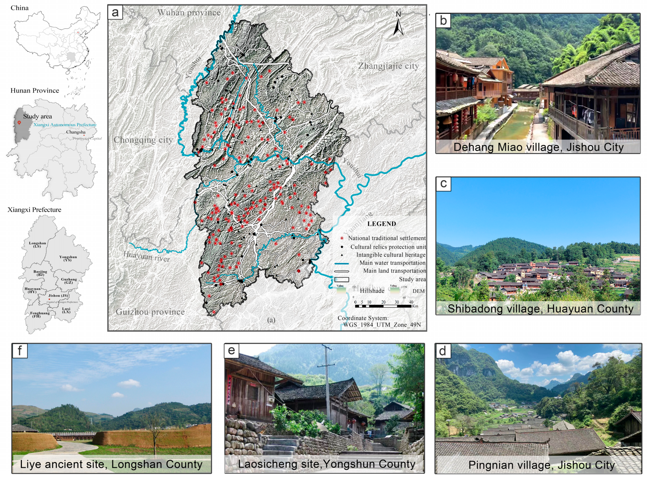
The Xiangxi Tujia and Miao Autonomous Prefecture (Xiangxi Prefecture) is located in the northwestern part of Hunan Province, China (N 27°44.5′–29°38′, E 109°10′– 110°22.5′) (Figure 1). Covering an area of 15,462 km2, Xiangxi Prefecture comprises eight administrative units. Xiangxi Prefecture is a typical mountainous multi-ethnic region, with mountains covering approximately two-thirds of its total area. There have been 43 ethnic groups living together in the region for a long time. A majority of Xiangxi’s population is composed of Tujia, Miao, Dong, and Bai ethnic groups. Tujia and Miao make up 77.47% of the total population, according to the seventh census taken in 2020. Most Tujia people reside in Yongshun, Baojing, and Longshan Counties, located in the northern and central regions. Most Miaos live in Huayuan, Fenghuang, Luxi, and Jishou counties, located in the southern and central regions.
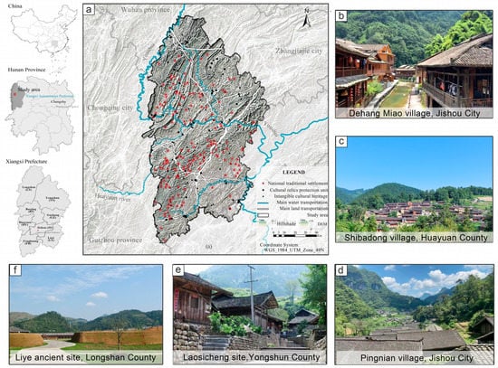
Figure 1.
The geographical location of Xiangxi Prefecture and the spatial distribution of its cultural heritage resources (a), as well as photographs taken at cultural heritage sites involving Dehang Miao village, Jishou City (b), Shibatong village, Huayuan County (c), Pingnian village, Jishou City (d), Laosicheng site in Yongshun County (e) and Liye ancient site, Longshan County (f).
The cultural heritage of Xiangxi Prefecture is rich and unique, with a strong folklore tradition. The most distinctive of these is the cultural heritage of traditional settlements inhabited by ethnic minorities, which includes 172 villages included in the list of Chinese traditional villages, as well as one famous historical and cultural city, four famous historical and cultural towns, and two famous historical and cultural villages. Traditional settlements are generally located on hills, and some of the farms are terraced along the slopes, and most of the buildings are dry-roofed and built with Chuan-Dou type timber frames, such as Dehang Miao village, Jishou City (Figure 1b), Shibadong village, Huayuan County (Figure 1c), and Pingnian village, Jishou City (Figure 1d). In addition, there are 13 national cultural relic protection units and 63 provincial cultural relic protection units. The main types of these are ancient buildings, ancient sites, ancient tombs, and old revolutionary sites, which date from the Palaeolithic era to modern times. Among them, the Laosicheng site in Yongshun County (Figure 1e) has been declared a World Heritage Site, as it contains physical evidence of the internal structure of tusi society, the tusi dominance system, and the relationship between the central government and minorities during the Ming Dynasty. The ancient site of Liye (Figure 1f) is famous for the excavation of 37,400 Qin bamboo slips during the period from the Warring States to the Qin and Han dynasties. It provides a valuable contribution to the study of the history of the Qin Dynasty (from 221 B.C. to 207 B.C.) in China. In addition, 110 intangible cultural heritage (ICH) items are protected at the national and provincial levels, primarily traditional folklore, dance, theatre, music, and handicrafts. There are accordingly, 83 inheritors. In particular, the Ganqiu Festival of the Miao ethnic group, which is still held in the region, has been inscribed on the UNESCO Representative List of the Intangible Cultural Heritage of Humanity. An extension of the “Twenty-four Chinese Lunar Festivals”, the festival celebrates the Miao people’s abundant harvest, combining song, dance, ritual, sports, and entertainment, which showcases the religious culture and folklore traditions of the Miao people.
In recent years, under the national policies of “rural revitalization” and “integration of culture and tourism”, Xiangxi Prefecture, as one of the 14 contiguous poor areas in China and a demonstration pilot area for tourism poverty alleviation, is developing an increasing number of cultural heritage sites and distinctive villages for tourism [33].
2.2. Methods
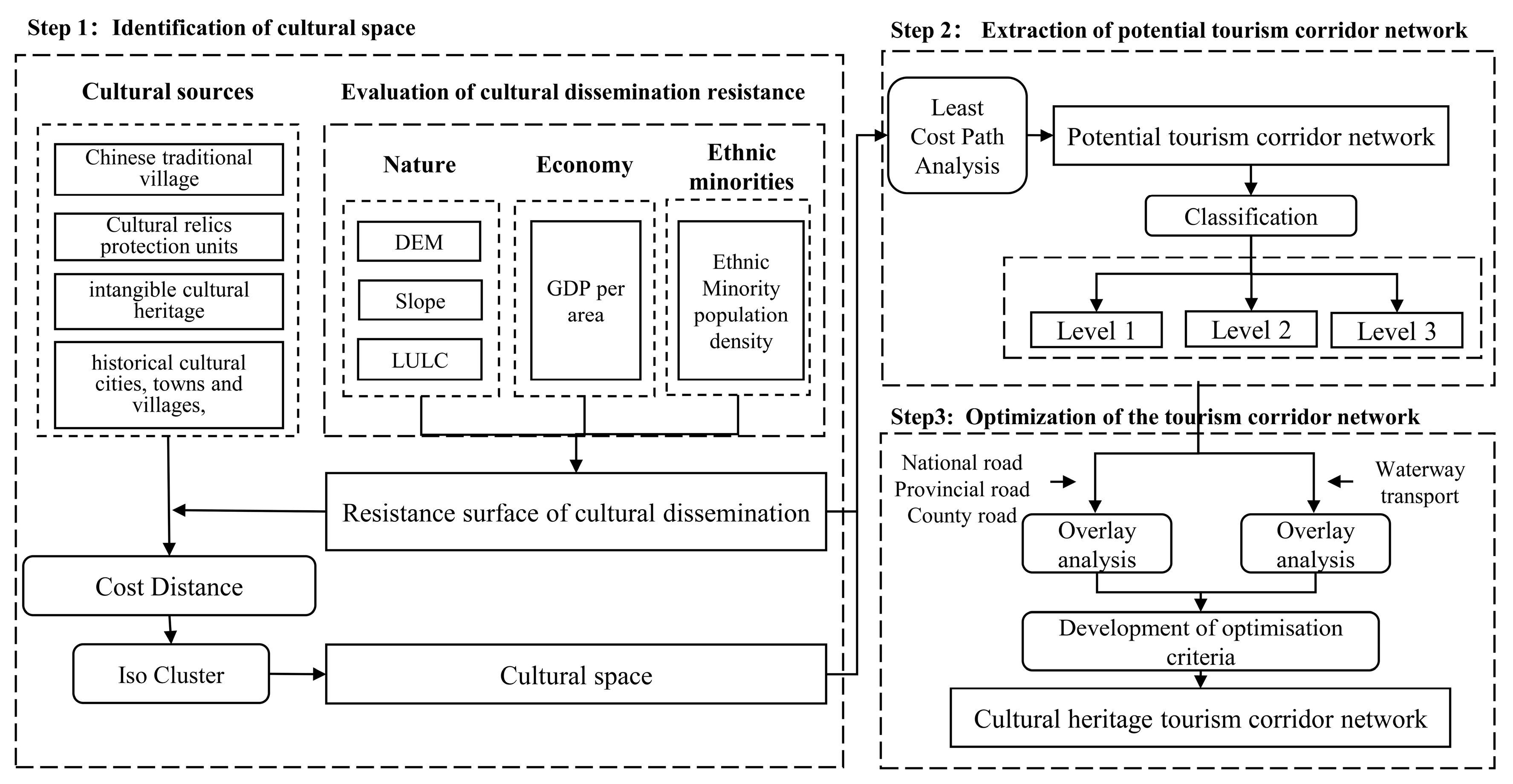
The cultural heritage tourism corridor network in this study is a linear transportation network that provides ethnic cultural experiences, tourism, and leisure. Cultural heritage tourism corridors, as opposed to heritage corridors and cultural routes that have been extensively studied, do not have a historical or cultural significance of their own. However, it can establish transport and cultural links to promote the conservation and use of the cultural heritage resources of the region through tourism. A cultural heritage tourism corridor network for Xiangxi Prefecture was to be constructed as follows (Figure 2): (1) The Least-Cost Distance model was used to identify cultural spaces (core areas with the lowest cumulative cost of spreading culturally influential historical and cultural heritage points) (see Section 2.2.1); (2) The potential corridors between cultural spaces were extracted using the least-cost path analysis (see Section 2.2.2); (3) Principles for adjusting and optimizing the potential corridors in relation to the current traffic distribution were developed to construct a network of cultural tourism corridors (see Section 2.2.3). The entire procedure was carried out using ArcGIS (10.5) software.
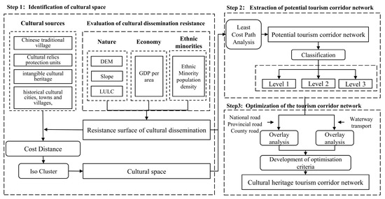
Figure 2.
Research framework.
The data used for the study and their sources and pre-processing were as follows:
- (1)
- Basic geographic data, such as administrative boundaries, water systems, and roads, were downloaded from the Resource and Environment Science and Data Centre (https://www.resdc.cn/, accessed on 1 July 2021).
- (2)
- Statistical data on Xiangxi Prefecture cultural sources (up to 2021), including Chinese Traditional Villages, Cultural Relic Protection Units (national and provincial levels), Intangible Cultural Heritage (ICH) (national and provincial levels), famous historical and cultural cities, towns, and villages at the national and provincial levels, were collected by the Bureau of Culture and Tourism in Xiangxi Prefecture (http://whlygdj.xxz.gov.cn/, accessed on 30 September 2021).
- (3)
- Indicators for evaluating cultural dissemination resistance included the digital elevation model (DEM), slope, land use and land cover (LULC), ethnic minority population density (EMPD), and spatial distribution of the gross domestic product (GDP). The original and processed data information for each factor are shown in Table 1.
 Table 1. Data information including type, time, acquisition, and processing.
2.2.1. Identification of Cultural Space
There were four processes for identifying cultural spaces: determining cultural sources, evaluating integrated resistance to cultural dissemination, creating integrated resistance surfaces, and extracting the boundary of cultural spaces.
Determination of Cultural Sources
In this study, cultural sources are historical and cultural heritage with a certain cultural influence in the region of Xiangxi Prefecture, including Chinese Traditional Villages, Cultural Relic Protection Units (national and provincial levels), Intangible Cultural Heritage (ICH) (national and provincial levels), as well as famous historical and cultural cities, towns, and villages at the national and provincial levels, which serve as both a “source” in the process of cultural dissemination and as a tourist destination. Due to the lack of a precise geospatial location for ICH items, their location was represented by the native places of the ICH inheritors. By using AutoNavi. Amap Api., the geographical locations of cultural sources were recorded and plotted on a map. Figure 1 demonstrates the 316 cultural sources with no repeat counts.
Evaluation of Cultural Dissemination Resistance
Factors such as natural, cultural, and economic factors influence the spatial distribution and dissemination of cultural heritage [34,35,36,37]. DEM, slope, and LULC indicators were chosen to evaluate the resistance of natural factors, taking into account the obstacles to cultural dissemination caused by elevation and slope, as well as the compatibility of various land cover types with cultural dissemination. In Xiangxi Prefecture, where tourism is the main source of income, regions are more equipped for developing cultural tourism and running into less resistance to the dissemination of culture as they become more prosperous. We used statistics on GDP per unit area to evaluate economic factors. In addition, ethnic culture influence is significant in areas where minority populations congregate. The distribution of ethnic minority population density (EMPD) was chosen to assess the resistance of ethnic factors, and these areas were more conducive to minority cultural dissemination; consequently, there was less resistance to cultural dissemination. Each factor’s resistance levels were divided into five classes, as shown in Table 2. These five classes were assigned resistance values at equal intervals from 1 to 100 (lowest to highest) [38,39].

Table 2.
A framework for evaluating cultural dissemination resistance, including the assignment of resistance values and the reason for the assignment.
Creation of an Integrated Resistance Surface
An integrated resistance surface can be created using the weighting method with the resistance factor system. The entropy weighting method (EWM), an objective way of determining weights that integrates valid information from all indicators, was utilized in this study to determine the weights of each factor. The effectiveness of its application in the fields of urban ecosystem research, construction of ecological security patterns, and ecosystem service assessment has been demonstrated in previous studies [40,41,42,43]. In this research, the EWM combined with the map algebra function of GIS was used to construct spatially based data indicators and determine the weights of each factor. The layers of these five factors were then weighted and overlapped to obtain an integrated resistance surface, which was divided into four resistance levels, 1–25, 25–50, 50–75, and 75–100.
Extraction of Cultural Space Boundary
Cultural spaces were extracted using the cost distance tool and ISO unsupervised classification tool in GIS. First, the cumulative resistance cost distance from each pixel to the cultural source was computed by the cost distance tool. Subsequently, the output cost distance raster was clustered by the ISO unsupervised classification tool, and the class with the minimum cost distance level was extracted as the cultural space. To reflect the disparities in importance, cultural spaces were evaluated using an indicator that showed the mean value of the kernel density (raster units) of the cultural sources in each space, represented by Ic. The Ic values were then separated into three intervals using the natural interval approach, signifying the three levels of importance of cultural spaces: I, II, and III. The cluster of cultural space I, which had the largest level of Ic values and thus represented the most important cluster, followed by II, which was the second-most important cluster, and III was last.
2.2.2. Identification of Potential Cultural Tourism Corridors
After determining the resistance surface and culture space, the Linkage Mapper toolbox software was used to identify the least-cost paths (LCPs). In Linkage Mapper 2.0 (LM), a GIS toolkit developed by McRae et al. [44], the Linkage Pathway tool is developed by the MCR model and can be used to identify LCPs [45]. Firstly, the centers of mass of the cultural spaces were extracted and represented as nodes. Then the nodes and the resistance surface were entered into the Linkage Pathway tool. This tool created a cost-weighted distance surface by calculating the cost-weighted distance (CWD) for each pixel from the near nodes, which allowed for the calculation of the minimum cost-weighted distance between nodes, and ultimately, the LCPs between nodes, i.e., the potential corridors, could be calculated. As shown in Table 3, the corridors were categorized according to the importance of the two cultural spaces they connected.

Table 3.
Division of corridor classes and their numbers.
2.2.3. Creation of a Cultural Heritage Tourism Corridor Network
The current distribution of land transportation (national highways, provincial highways, and county highways) and waterways were utilized based on the potential corridors to construct a cultural heritage tourism corridor network across the territory. The relevant criteria were set as follows.
- (1)
- When there were highways between the nodes, priority was given to the use of existing highways. If several highways were available, the highway with a higher administrative grade was prioritized.
- (2)
- When there were no highways between the nodes, potential corridors were used. If there were several potential corridors, one was selected in order of priority as Level 1, Level 2, and Level 3. If a section of a potential corridor overlaps with an existing road, that section could use the existing road.
- (3)
- There should be only three corridors linking a node.
- (4)
- Historical and culturally significant navigable waterways were used to supplement the corridors. Depending on the actual scenario, a marina may be built at the junction of a waterway and a potential corridor.
The nodes and their connecting corridors were numbered. New node numbers were added at the endpoints where corridor levels switched when there were two or more different levels of the corridor between two nodes. The corridors between the nodes were then numbered in order of importance and length. Finally, the total length and the length of existing roads of the proposed planning corridors (potential cultural tourism corridors) for each corridor were counted.
3. Results
3.1. Cultural Dissemination Resistance Surface
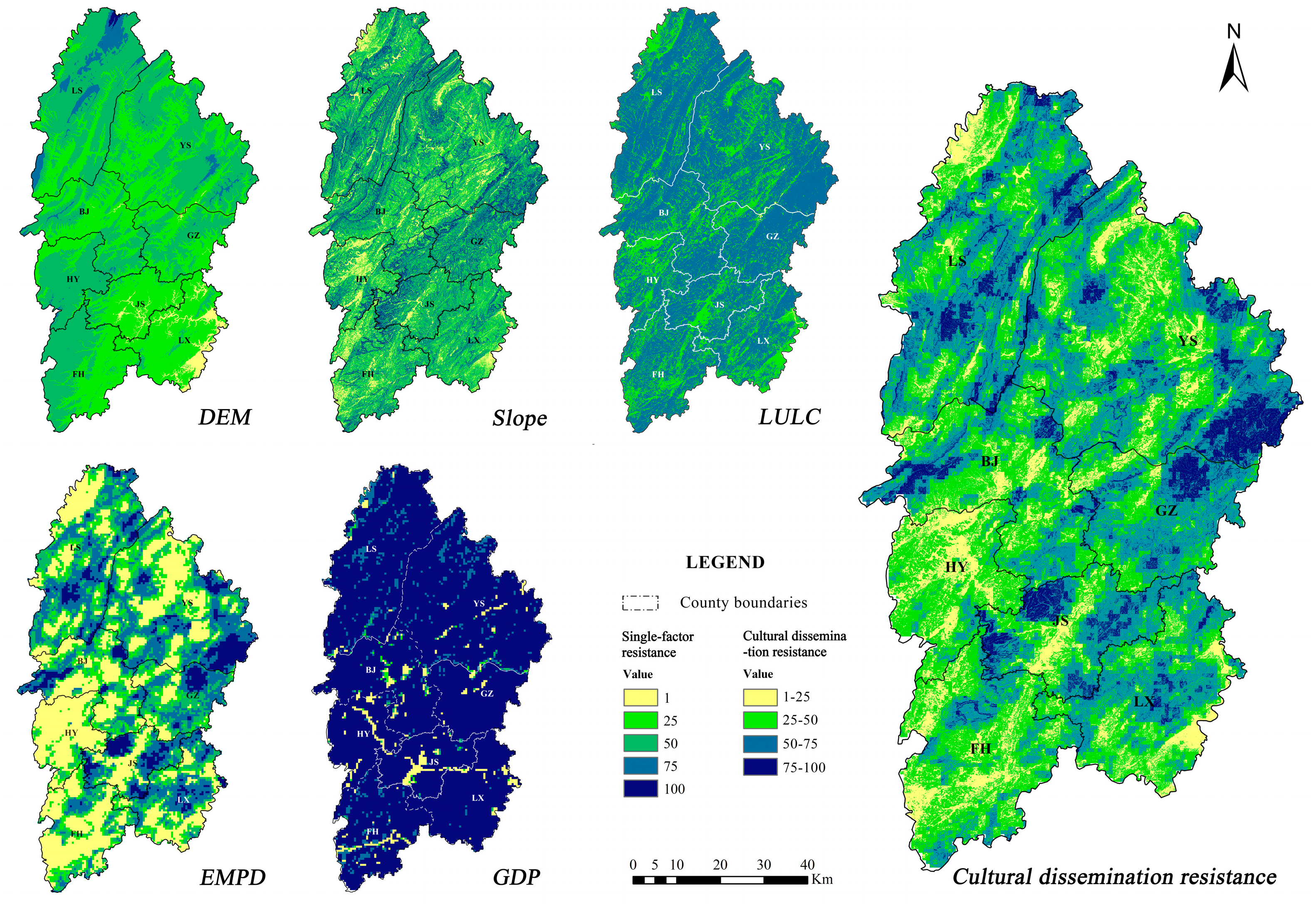
The weights of the DEM, slope, LULC, EMPD, and GDP factors were computed using the entropy weighting method to be 0.1026, 0.3099, 0.0398, 0.4567, and 0.091, respectively. Following the weighted overlay of these factors, the results of the integrated resistance surface were divided into four intervals: 1–25, 25–50, 50–75, and 75–100, resulting in the “low resistance area”, “middle resistance area”, “high resistance area”, and “extremely high resistance area”, as shown in Figure 3.
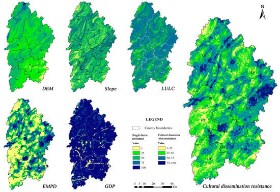
Figure 3.
The distribution map of single-factor resistance and cultural dissemination resistance. LS, YS, BJ, GZ, HY, JS, LX, and FH represent Jishou City, Longshan County, Yongshun County, Baojing County, Guzhang County, Huayuan County, Luxi County, and Fenghuang County in Xiangxi Prefecture, respectively.
Based on the results, there was a significant difference in the spatial distribution of cultural resistance among ethnic minorities in Xiangxi Prefecture, and the combined resistance was primarily influenced by EMPD. The “extremely high resistance area” covered approximately 1.37 × 10⁵ ha, mainly in Longshan County (LS), Guzhang County (GZ), and Jishou County (JS). Jishou’s “extremely high resistance area” was not conducive to cultural diffusion, primarily due to the low density of minorities in this area. The “extremely high resistance areas” near in Longshan and Guzhang counties demonstrated a high level of resistance to all five factors, primarily as a result of the disadvantageous natural environment (high mountains, steep slopes and dense forests). In the nearby “high resistance zone”, with an area of approximately 5.67 × 10⁵ hectares, the density of minority populations, the level of economic development, land use patterns, and topography hinder the spread of culture, and the “low resistance zone” of about 2.72 × 10⁵ ha, was concentrated in the southwest. There was little resistance to cultural dissemination in these areas because of the high density of ethnic minority populations and relatively flat terrain. However, some of the resistance was because the more dense forests within the territory needed to be protected from human disturbance.
3.2. Cultural Space
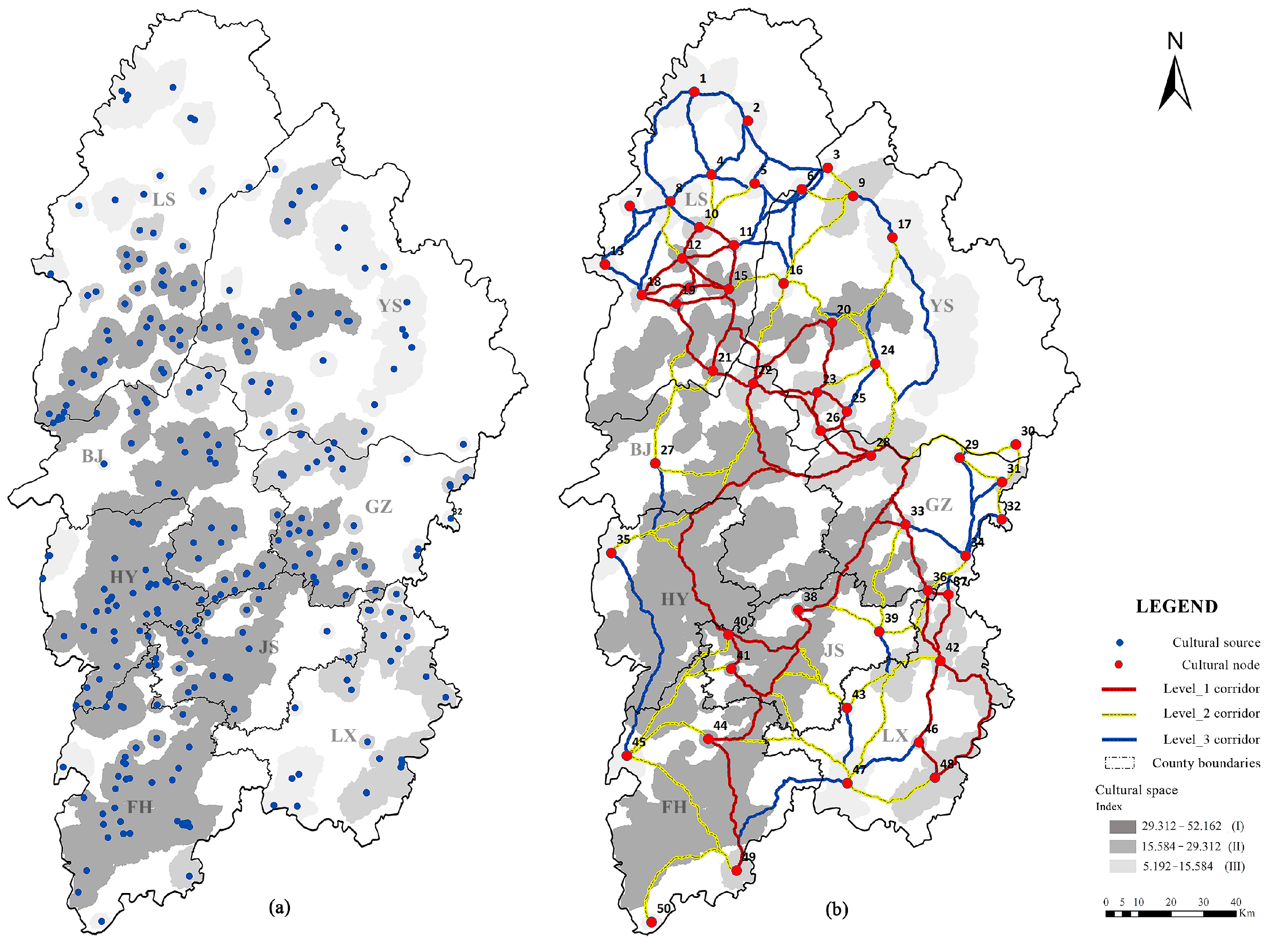
The cultural space identification results based on the cost–distance analysis were as follows (Figure 4a): (1) there were 50 cultural spaces covering an area of 7.37 × 10⁵ hectares, accounting for 47% of the total area. (2) There were 11 spaces categorized as the primary cultural space (I), with an indicator of cultural impotence value (Ic) between 29.312 and 52.162. They were concentrated in the central and southwestern regions. They were either concentrated or contiguous, as in the case of the largest space, which spanned Jishou city, Fenghuang County, Huayuan County, Baojing County, and Guzhang County, covering a total area of 3.46 × 10⁵ ha with 148 cultural source sites, accounting for 46.84% of all source sites, or isolated and dispersed, as in the case of the smallest space, which covered an area of only 866.07 ha with one cultural source site; There were 16 secondary cultural spaces (II), Ic ∈ (15.584–29.312), with 58 cultural source sites. Most of them were dispersed in the southeast and centre of Xiangxi Prefecture. These areas were close to the primary cultural space (I). In addition, there were 23 patches of tertiary cultural space (III), Ic ∈ (5.192–15.584), with 46 cultural source sites. Most of them were dispersed in the north (Longshan and Yongshun Counties) and isolated at the margin areas.
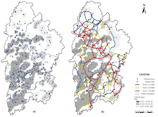
Figure 4.
The spatial distribution of cultural space (a) and potential cultural heritage tourism corridor network (b).
3.3. Potential Cultural Heritage Tourism Corridors
A total of 50 centres of mass were extracted from the cultural space patches and represented as nodes connecting the corridor network. The potential corridors between them were extracted (Figure 4b). The results demonstrated that; (1) there were 122 corridors, totaling 3055.14 km; (2) the spatial layout of the corridors was impacted by the distribution of the centers of mass and demonstrated in a network pattern with sparse density in the center and dense density outside; and (3) the level_1 corridors (42 in total) were distributed north-south and created a loop wire in the region’s center, which spanned seven counties and one city across Xiangxi Prefecture. They connected 20 cultural spaces (8 in I, 12 in II); in connection with the level_1 corridors, the level_2 corridors (42 in total) were evenly spaced out around them and connected 34 cultural spaces (10 in I, 7 in II, 17 in III); The level_3 corridors (38 in total) were scattered throughout Xiangxi Prefecture, but most were concentrated in northern Longshan County, which connected 34 cultural spaces (7 in II, 16 in III).
3.4. Cultural Heritage Tourism Corridor Network
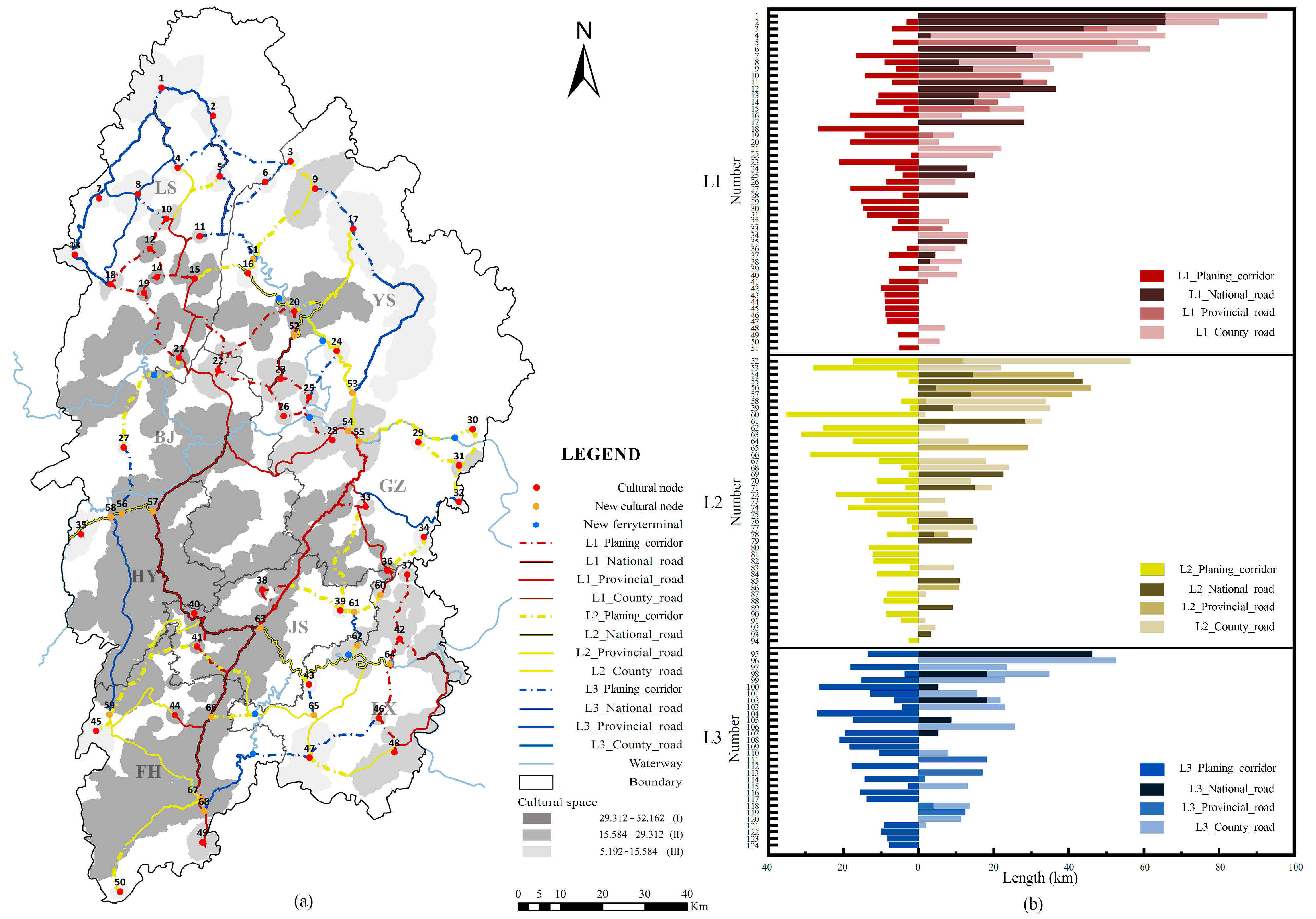
The final cultural heritage tourism corridor network is shown in Figure 5a. This consisted of existing highways and proposed planned corridors (potential corridors), which were largely consistent with the basic distribution pattern of the potential corridor network (Figure 4). In addition to the 50 nodes, 18 new nodes were added at the endpoints of the corridor level shift. Table 4 shows the 124 cultural heritage tourism corridors (land transport) between the nodes, along with the corresponding numbers. Figure 5b shows the total length of each corridor, the length of the existing highways (national, provincial, and county highways), the length of the planned corridors, and the percentage of the existing roads. Additionally, 13 waterways were supplemented, as well as 10 water transport terminals.
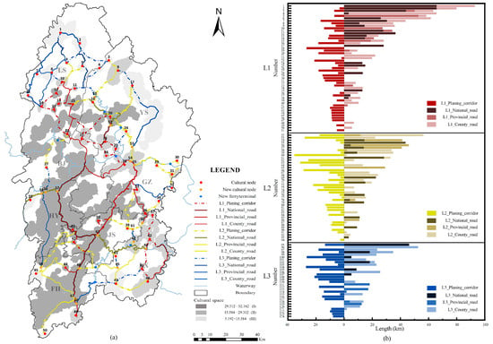
Figure 5.
The spatial distribution of the cultural heritage tourism corridor network (a) and the type and length distribution of the corridors (b).

Table 4.
Corresponding numbers and node segments (S) of corridors.
The Level_1 corridor (numbered 1–51) had a total length of 1329.54 km. The length of the existing roads made up 71.21% of the total length of the corridors, which was greater than the length of the planned corridors (946.80 km for the existing roads and 382.75 km for the planned corridors). Approximately 46.98% of existing roads were national roads, which have the longest length. National roads (G316 and G209), which are approximately 6–9 m wide, run through the largest area of the primary cultural spaces. Along the roads, there were 26 cultural sources, including the famous Ancient Town of Fenghuang, Dehang Miao Village, Aizhai, and Shibadong Village. Approximately 39.30% of the total was devoted to county roads. There were a large number of county roads, but they were generally short and needed to be combined with the planned corridors to link relatively fragmented but important cultural spaces. In contrast, provincial roads contributed less (approximately 13.72%).
There were 43 Level_2 corridors (numbered 52–94) with a total length of 1009.42 km, which were connected to the Level_1 corridor and played an important role in connecting the primary cultural spaces with the secondary and tertiary cultural spaces scattered throughout the southeast and east (Figure 5a). Compared to the Level_1 corridor, the proportion of existing road length in the Level_2 corridor decreased, but the length contribution by existing roads still dominated. (615.11 km for the current roads compared to 394.30 km for the planned corridor). In terms of existing road types, county roads (including XU06, XU11, XU41) contributed the most in length (approximately 41.57%). They are approximately 4–5 m wide and are mostly located in southern Xiangxi, followed by national roads (approximately 33.74%) and provincial roads (24.69%).
The total length of the 30 Level_3 corridor (numbered 95–124) was 675.70 km. Linked to the Level_1 and Level_2 corridors, primarily creating links between relatively isolated secondary and tertiary cultural spaces. However, the proportion of the existing road length decreased further. The existing road length was slightly greater than the planned corridor length (361.40 km for the current road and 314.31 km for the planned corridor). Among the existing roads, county roads comprised 62.30% of the total corridor length (including XU04, XU08, XU12) and were approximately 4–5 m wide, while national and provincial roads constituted a smaller proportion.
In summary, 63.80% of the total corridor length was covered by existing roads. The Level_1 corridor was the longest of the three types of corridors, connecting important cultural spaces in the north and south of Xiangxi Prefecture, and could serve as the artery for planning heritage tourism. There was the greatest use of existing roads in the Level_1 corridor, and the existing roads were mainly composed of national roads. Among them, sections of National Highways G316 and G209, which had intact road infrastructure and many famous heritage tourist attractions along the way, could be planned and constructed on the basis of the status quo. The level_2 corridor was slightly shorter than the level_1 corridor and served a vital role in the connection and integration of cultural spaces. The existing roads in the Level_2 corridor were mostly county roads, and they needed to be combined with planned corridors to support the connection and integration of cultural spaces. The Level_3 corridor was the shortest in length, but these corridors brought discrete cultural spaces into the network system, further expanding the scope of cultural heritage protection and use. The existing roads in the Level_3 corridors were mainly county roads. Among the three types of corridors, there was little difference in the length of the planned corridors.
4. Discussion
Due to the limited accessibility of transportation in mountainous areas, this study proposes a method for constructing a cultural heritage tourism corridor network suitable for mountainous ethnic areas based on the integration of cultural heritage resources. By directing the development of the regional transportation network according to the spatial layout and corridor levels of the tourism corridor network, existing transportation links and accessibility to cultural heritage in the region will be greatly improved. This will facilitate cultural exchange and dissemination between heritage sites. Additionally, it has the potential to promote the balanced development of regional cultural heritage tourism, thus promoting the overall conservation and utilization of regional cultural heritage. The results of the study may provide an idea for promoting the preservation and use of regional cultural heritage in other mountainous ethnic areas and inaccessible regions. The method of corridor network construction from landscape ecology, least-cost path analysis based on the MCR model, was applied to the construction of cultural heritage tourism corridor networks. From the perspective of heritage utilization, this method can simulate the least cumulative resistance pathway for cultural exchange and dissemination between cultural heritage sites to quickly identify the optimal pathway for cultural dissemination and construct a regional cultural heritage tourism corridor network. Additionally, from the perspective of heritage conservation, a multiscale cultural heritage spatial structure of “cultural heritage sources—cultural spaces—a corridor network” can also be formed using the method, enhancing both the spatial structure integrity and intrinsic cultural relevance among heritage sites.
The key to the identification of the potential tourism network lies in the determination of cultural dissemination resistance factors and the allocation of resistance coefficients. Relative studies have tended to focus on natural factors, such as elevation, topographic relief, slope, type of land cover, and other indicators [28,29,38,46]. Huang et al. considered social factors such as cultural value, population distribution, and food and beverage services from the perspective of culture, ecotourism, and leisure [47]. Despite this, the factors that evaluate the aspect of culture were not sufficiently interpreted, mainly because they were mostly studied qualitatively and were difficult to quantify. Natural, cultural, and economic factors strongly influence cultural dissemination in mountainous ethnic areas, so in this study, we tried to quantitatively evaluate the impact of cultural aspects. Based on the region’s current situation and the data resources available, the population density of ethnic minorities was chosen as an indirect indicator to evaluate cultural dissemination resistance. Regions with large concentrations of minorities make it easier to accomplish the traditional cultural exchange. In contrast, traditional culture is vulnerable to the influence of modern culture in places where there are few ethnic minorities. Therefore, it can be assumed that there is a higher resistance in these places. Moreover, the GDP per area indicator was chosen to represent the economic factor. In regard to GDP resistance, areas with high GDP were less resistant to cultural dissemination since these areas are able to provide significant financial support for the preservation of cultural heritage and tourism development in Xiangxi where cultural tourism is highly valued. The development of tourism, however, is associated with a relatively higher degree of modernization which, if not properly protected and utilized, may have a negative effect on the maintenance and preservation of historical and cultural heritage. In this study, GDP assignments were examined from the perspective of facilitating cultural dissemination. Our next study will attempt to strike a balance between the diffusion and preservation of culture and determine an appropriate GDP grading system.
Cultural sources are usually determined either by the individual cultural heritage sites directly or by clusters of cultural heritage sites based on nuclear density analysis. This study did not directly utilize these sites as sources. On the one hand, the large number of heritage sites and their clustering would result in redundant and duplicate corridor construction, which increases both the environmental and economic costs associated with corridor construction. On the other hand, integrating geographically near sites into the same heritage conservation and management spaces was more conducive to strengthening their bonds and protecting the continuity and integrity of the heritage landscape. In addition, using kernel density analysis to identify cultural spaces neglected the influence of natural and social factors, such as topography and population distribution surrounding the heritage sites. Multiple factors were taken into account when using the least-cost distance to identify the spaces. To evaluate the importance of cultural spaces, this study used the kernel density value of cultural source points per unit area. Spaces that contain a high density of sources are considered to be of greater cultural significance for the holistic conservation of cultural heritage. Despite the differences in the cultural impact of individual sources, this article emphasized their value as a whole in terms of the conservation and use of heritage.
A relatively high level of integration (63.80%) was achieved between the potential cultural tourism corridors and the existing highways. The selection and assignment of resistance factors contributed to this result since the current road traffic and surrounding land were gently sloped, predominantly in the plains of the central and south-eastern part of the study area, where ethnic minorities and tourism activities interacted relatively frequently. Accordingly, the areas that were adjacent to existing roads had a relatively low resistance cost distance, both in terms of natural and human factors, thus being close to the identified least-cost paths. Using the existing roads close to the corridor alignments allowed for maximum respect and use of existing traffic roads, as well as reducing environmental damage and cost from a carbon perspective. By replacing the potential corridors with existing roads that are close to their alignment, existing traffic roads will be conserved and used more efficiently, corridor construction costs will be reduced from a low carbon perspective and environmental damage will be reduced. The Level_1 corridor had the highest utilization of existing roads, as the cultural heritage of Xiangxi Prefecture is concentrated in the south-western and central parts of the state, where the transport network is relatively dense and can be utilized for heritage tourism planning. The existing roads of the Level_2 and Level_3 corridors were less utilized, as they connected to the secondary and tertiary cultural spaces in the north and south-east of Xiangxi Prefecture, where there were fewer existing roads due to the topography or land use patterns.
The graded construction and optimization of the corridor network provided a useful reference for the planning of regional heritage tourism and the organization of tourist routes. Since the Level_1 corridor had the highest utilization rate of existing roads, as well as serving as the backbone of the corridor, it is recommended that it be constructed first. It is possible to determine the width of the corridor by comparing it to the width of a national road. It connects the largest number of cultural heritage resources and can highlight the unique heritage-type characteristics of different along the corridor. In order to enhance the visitor experience of corridor tourism, it is necessary to delineate thematic display areas and provide the necessary equipment and leisure facilities for the deployment of cultural interpretation systems and tourism services. The Level_2 and Level_3 corridors play an important role in connecting and integrating cultural spaces and will be constructed and improved in turn. It consisted mostly of county road sections as well as proposed potential corridors, and the corridor width can be the width of a county road. Level_3 corridors can be planned according to demand, with bicycle paths, trails and other slow-moving facilities to build a green, low-carbon, eco-friendly corridor slow-moving system, promoting interaction between tourists and the cultural heritage landscape as part of the tourism process. It is also possible to apply the concept of delineating cultural spaces and the creation of cultural tourism corridors to the practice of conserving and utilizing cultural heritage across regions in an integrated manner. The creation of cultural spaces takes into account the natural, human, and economic influences on the dissemination of culture and focuses not only on the objects of cultural heritage conservation themselves but also on the comprehensive protection of their ecological environment, the historical and cultural, and the human element environment. At the level of resource development and utilization, it is also more conducive to breaking through the limitations of the administrative area and integrating traditional settlements with the surrounding tourism resources to create a joint heritage tourism function area. Regarding resource development and utilization, it is also more conducive to overcoming the limitations imposed by the administrative area, and integrating historical and cultural heritages with the surrounding tourism resources, creating different heritage tourism function areas. By utilizing the opportunity of tourism development, it is possible to delineate cultural tourism corridors and connect cultural spaces across districts, transforming regional tourism from a single scenic tourism model to a comprehensive development and integration of cultural heritage resources, injecting vitality into cultural heritage while also allowing it to be protected in development.
Considering the large number of heritage sites, cultural spaces were identified first. Then, mass centers were extracted to construct the main structure of the tourism corridor network. Therefore, tourism corridors serve primarily as a means of connecting cultural spaces. Within cultural spaces, cultural transmission is relatively easy, which allows tourists to reach all heritage sites relatively easily once they arrive. However, since transport routes within cultural spaces may take a variety of forms, this study did not explore specific routes of transportation. In addition, this study identified the linear distribution of cultural heritage tourism corridors primarily at a regional scale and proposed that the widths of the different levels of corridors can be based on the widths of the current traffic types, but the specific widths of each corridor were not quantified. The next step will be to examine methods of integration and traffic patterns between cultural source points within cultural spaces, especially for cultural spaces with large areas and a large number of cultural sources. In addition, quantitative approaches for determining the width of cultural heritage tourism corridors should be explored, taking into account the regional characteristics of mountainous ethnic areas to improve the manipulability of corridor construction.
5. Conclusions
A cultural heritage tourism corridor network was constructed in this study to improve transport accessibility and promote regional cultural exchange in Xiangxi Prefecture and other inaccessible mountainous multi-ethnic regions.
The research can contribute to the sustainable integration between cultural heritage and tourism in mountainous ethnic areas. In terms of heritage sustainability, this study focuses not only on the single conservation of cultural heritages themselves but also on the integrated protection of their ecological environment, the historical and cultural and the human element environment, and promoting the revitalization, renewal, and dissemination of regional cultural heritages through the creation of transport links and the development of tourism; in terms of tourism sustainability, by creating an improved transportation network of the region, the potential for tourism development and integration of cultural heritages will be improved. Consequently, heritage may serve as a fulcrum for the integration of a variety of resources or as a complement to economic growth, thereby facilitating the collaboration between tourism and other industries. In future work, by evaluating the cultural heritage tourism corridor network objectively and realistically, it will be possible to guide the development of cultural tourism in mountainous multi-ethnic areas in a more balanced and sustainable manner.
Author Contributions
Y.H., conceptualization, data curation, methodology, investigation, software, visualization, writing—original draft, writing—review and editing. G.L., conceptualization, data curation, validation, formal analysis, writing—original draft, writing—review and editing, supervision, funding acquisition. S.S., writing—review and editing, supervision. W.H., data curation, software, visualization, supervision. Y.L., data curation, visualization. All authors have read and agreed to the published version of the manuscript.
Funding
This research was funded by the National Natural Science Foundation of China [grant number 32001363], the Hunan Provincial Innovation Foundation for Postgraduate [grant number CX20220742] and the Scientific Research Foundation of Hunan Provincial Education Department [grant number 21B0235].
Institutional Review Board Statement
Not applicable.
Informed Consent Statement
Not applicable.
Data Availability Statement
Not applicable.
Conflicts of Interest
The authors declare no conflict of interest.
References
- Michaud, J.; Ovesen, J. Turbulent Times and Enduring Peoples: Mountain Minorities in the South-East Asian Massif; Routledge: London, UK, 2013; ISBN 1136827811. [Google Scholar]
- Salzer, A.K. Knowledge for Sustainability-Cultural Capital of Ethnic Minorities in High Mountain Areas of the South Caucasus; Agricultural Knowledge and Knowledge Systems in Post-Soviet Societies; Peter Lang: Bern, Switzerland, 2016; pp. 127–156. [Google Scholar] [CrossRef]
- Goldstein, P.S. Multiethnicity, Pluralism, and Migration in the South Central Andes: An Alternate Path to State Expansion. Proc. Natl. Acad. Sci. USA 2015, 112, 9202–9209. [Google Scholar] [CrossRef] [PubMed]
- Yang, L.; Wall, G.; Smith, S.L.J. Ethnic Tourism Development: Chinese Government Perspectives. Ann. Tour. Res. 2008, 35, 751–771. [Google Scholar] [CrossRef]
- Yang, L.; Wall, G. Authenticity in Ethnic Tourism: Domestic Tourists’ Perspectives. Curr. Issues Tour. 2009, 12, 235–254. [Google Scholar] [CrossRef]
- Anderson, W. Cultural Tourism and Poverty Alleviation in Rural Kilimanjaro, Tanzania. J. Tour. Cult. Chang. 2015, 13, 208–224. [Google Scholar] [CrossRef]
- Tu, J.; Zhang, D. Does Tourism Promote Economic Growth in Chinese Ethnic Minority Areas? A Nonlinear Perspective. J. Destin. Mark. Manag. 2020, 18, 100473. [Google Scholar] [CrossRef]
- Mowforth, M.; Munt, I. Tourism and Sustainability: Development, Globalisation and New Tourism in the Third World; Routledge: London, UK, 2015; ISBN 1315795345. [Google Scholar]
- Tian, B.; Stoffelen, A.; Vanclay, F. Ethnic Tourism in China: Tourism-Related (Dis)Empowerment of Miao Villages in Hunan Province. Tour. Geogr. 2021, 1–20. [Google Scholar] [CrossRef]
- Sati, V.P. Carrying Capacity Analysis and Destination Development: A Case Study of Gangotri Tourists/Pilgrims’ Circuit in the Himalaya. Asia Pac. J. Tour. Res. 2018, 23, 312–322. [Google Scholar] [CrossRef]
- Xu, H.; Zhao, G.; Fagerholm, N.; Primdahl, J.; Plieninger, T. Participatory Mapping of Cultural Ecosystem Services for Landscape Corridor Planning: A Case Study of the Silk Roads Corridor in Zhangye, China. J. Environ. Manag. 2020, 264, 110458. [Google Scholar] [CrossRef]
- Liu, G.; Yang, Z.; Chen, B.; Zhang, L.; Zhang, Y.; Su, M. An Ecological Network Perspective in Improving Reserve Design and Connectivity: A Case Study of Wuyishan Nature Reserve in China. Ecol. Model. 2015, 306, 185–194. [Google Scholar] [CrossRef]
- Zhou, D.; Song, W. Identifying Ecological Corridors and Networks in Mountainous Areas. Int. J. Environ. Res. Public Health 2021, 18, 4797. [Google Scholar] [CrossRef]
- Forman, R.T.T. Some General Principles of Landscape and Regional Ecology. Landsc Ecol 1995, 10, 133–142. [Google Scholar] [CrossRef]
- Hess, G.R.; Fischer, R.A. Communicating Clearly about Conservation Corridors. Landsc. Urban Plan 2001, 55, 195–208. [Google Scholar] [CrossRef]
- Xu, H.; Plieninger, T.; Primdahl, J. A Systematic Comparison of Cultural and Ecological Landscape Corridors in Europe. Land 2019, 8, 41. [Google Scholar] [CrossRef]
- Zhang, S.; Liu, J.; Pei, T.; Chan, C.-S.; Wang, M.; Meng, B. Tourism Value Assessment of Linear Cultural Heritage: The Case of the Beijing–Hangzhou Grand Canal in China. Curr. Issues Tour. 2021, 1–23. [Google Scholar] [CrossRef]
- Boley, B.B.; Gaither, C.J. Exploring Empowerment within the Gullah Geechee Cultural Heritage Corridor: Implications for Heritage Tourism Development in the Lowcountry. J. Herit. Tour. 2016, 11, 155–176. [Google Scholar] [CrossRef]
- Conzen, M.P.; Wulfestieg, B.M. Metropolitan Chicago’s Regional Cultural Park: Assessing the Development of the Illinois \& Michigan Canal National Heritage Corridor. J. Geogr. 2001, 100, 111–117. [Google Scholar] [CrossRef]
- Murray, M.; Graham, B. Exploring the Dialectics of Route-Based Tourism: The Camino de Santiago. Tour. Manag. 1997, 18, 513–524. [Google Scholar] [CrossRef]
- Orbaşli, D.A.; Woodward, S. A Railway ‘Route’ as a Linear Heritage Attraction: The Hijaz Railway in the Kingdom of Saudi Arabia. J. Herit. Tour. 2008, 3, 159–175. [Google Scholar] [CrossRef]
- Li, H.; Jing, J.; Fan, H.; Li, Y.; Liu, Y.; Ren, J. Identifying Cultural Heritage Corridors for Preservation through Multidimensional Network Connectivity Analysis—A Case Study of the Ancient Tea-Horse Road in Simao, China. Landsc. Res. 2020, 46, 96–115. [Google Scholar] [CrossRef]
- Oikonomopoulou, E.; Delegou, E.T.; Sayas, J.; Moropoulou, A. An Innovative Approach to the Protection of Cultural Heritage: The Case of Cultural Routes in Chios Island, Greece. J. Archaeol. Sci. Rep. 2017, 14, 742–757. [Google Scholar] [CrossRef]
- Balakrishnan, J.; Dwivedi, Y.K.; Malik, F.T.; Baabdullah, A.M. Role of Smart Tourism Technology in Heritage Tourism Development. J. Sustain. Tour. 2021, 1–20. [Google Scholar] [CrossRef]
- Palmi, P.; Esposito, M.; Prete, M.I. Change in Perspectives in Cultural Tourism: A Sustainable Managerial Model for Cultural Thematic Routes Creating Territorial Value. In Contributions to Management Science; Springer: Berlin/Heidelberg, Germany, 2021; pp. 199–223. [Google Scholar] [CrossRef]
- Hoppert, M.; Bahn, B.; Bergmeier, E.; Deutsch, M.; Epperlein, K.; Hallmann, C.; Müller, A.; Platz, T.V.; Reeh, T.; Stück, H.; et al. The Saale-Unstrut Cultural Landscape Corridor. Environ. Earth Sci. 2018, 77, 58. [Google Scholar] [CrossRef]
- Shishmanova, M.V. Cultural Tourism in Cultural Corridors, Itineraries, Areas and Cores Networked. Procedia Soc. Behav. Sci. 2015, 188, 246–254. [Google Scholar] [CrossRef]
- Wu, S.; Li, B.V. Sustainable Linear Infrastructure Route Planning Model to Balance Conservation and Socioeconomic Development. Biol. Conserv. 2022, 266, 109449. [Google Scholar] [CrossRef]
- Dong, J.; Guo, F.; Lin, M.; Zhang, H.; Zhu, P. Optimization of Green Infrastructure Networks Based on Potential Green Roof Integration in a High-Density Urban Area—A Case Study of Beijing, China. Sci. Total Environ. 2022, 834, 155307. [Google Scholar] [CrossRef]
- Stucky, J.L.D. On Applying Viewshed Analysis for Determining Least-Cost Paths on Digital Elevation Models. Int. J. Geogr. Inf. Sci. 1998, 12, 891–905. [Google Scholar] [CrossRef]
- Akimov, A.V.; Gemueva, K.A.; Semenova, N.K. The Seventh Population Census in the PRC: Results and Prospects of the Country’s Demographic Development. Her. Russ. Acad. Sci. 2021, 91, 724–735. [Google Scholar] [CrossRef]
- Su, J.; Sun, J. Spatial Changes of Ethnic Communities during Tourism Development: A Case Study of Basha Miao Minority Community. J. Tour. Cult. Chang. 2020, 18, 333–350. [Google Scholar] [CrossRef]
- Liu, C.; Wu, L.; Xu, M.; Zeng, F.; Jiao, L. Building National Eco-Cultural Protection Areas and the Xiangxi Practice in Hunan Province. J. Geogr. Sci. 2020, 30, 2076–2092. [Google Scholar] [CrossRef]
- Zhang, X.; Xiang, H.; Liu, R. Spatial Pattern and Influencing Factors of Intangible Cultural Heritage of Music in Xiangxi, Central China. Herit. Sci. 2022, 10, 39. [Google Scholar] [CrossRef]
- Chen, X.; Xie, W.; Li, H. The Spatial Evolution Process, Characteristics and Driving Factors of Traditional Villages from the Perspective of the Cultural Ecosystem: A Case Study of Chengkan Village. Habitat. Int. 2020, 104, 102250. [Google Scholar] [CrossRef]
- Bian, J.; Chen, W.; Zeng, J. Spatial Distribution Characteristics and Influencing Factors of Traditional Villages in China. Int. J. Environ. Res. Public Health 2022, 19, 4627. [Google Scholar] [CrossRef] [PubMed]
- Li, W.; Jiao, J.; Qi, J.; Ma, Y. The Spatial and Temporal Differentiation Characteristics of Cultural Heritage in the Yellow River Basin. PLoS ONE 2022, 17, 1–20. [Google Scholar] [CrossRef]
- Cao, Y.; Yang, R.; Carver, S. Linking Wilderness Mapping and Connectivity Modelling: A Methodological Framework for Wildland Network Planning. Biol. Conserv. 2020, 251, 108679. [Google Scholar] [CrossRef]
- Huang, L.; Wang, J.; Cheng, H. Spatiotemporal Changes in Ecological Network Resilience in the Shandong Peninsula Urban Agglomeration. J. Clean. Prod. 2022, 339, 130681. [Google Scholar] [CrossRef]
- Han, B.; Liu, H.; Wang, R. Urban Ecological Security Assessment for Cities in the Beijing–Tianjin–Hebei Metropolitan Region Based on Fuzzy and Entropy Methods. Ecol. Model. 2015, 318, 217–225. [Google Scholar] [CrossRef]
- Ludovisi, A. Effectiveness of Entropy-Based Functions in the Analysis of Ecosystem State and Development. Ecol. Indic. 2014, 36, 617–623. [Google Scholar] [CrossRef]
- Dai, P.; Zhang, S.; Gong, Y.; Yang, Y.; Hou, H. Assessing the Inspirational Value of Cultural Ecosystem Services Based on the Chinese Poetry. Acta Ecol. Sin. 2022, 42, 467–475. [Google Scholar] [CrossRef]
- Tang, Z. An Integrated Approach to Evaluating the Coupling Coordination between Tourism and the Environment. Tour. Manag. 2015, 46, 11–19. [Google Scholar] [CrossRef]
- McRae, B.H.; Shah, V.B. Circuitscape User’s Guide; The University of California: Santa Barbara, CA, USA, 2009. [Google Scholar]
- Adriaensen, F.; Chardon, J.P.; de Blust, G.; Swinnen, E.; Villalba, S.; Gulinck, H.; Matthysen, E. The Application of ‘Least-Cost’ Modelling as a Functional Landscape Model. Landsc. Urban Plan 2003, 64, 233–247. [Google Scholar] [CrossRef]
- Dai, L.; Liu, Y.; Luo, X. Integrating the MCR and DOI Models to Construct an Ecological Security Network for the Urban Agglomeration around Poyang Lake, China. Sci. Total Environ. 2021, 754, 141868. [Google Scholar] [CrossRef] [PubMed]
- Huang, H.; Zhang, M.; Yu, K.; Gao, Y.; Liu, J. Construction of Complex Network of Green Infrastructure in Smart City under Spatial Differentiation of Landscape. Comput. Commun. 2020, 154, 380–389. [Google Scholar] [CrossRef]
Disclaimer/Publisher’s Note: The statements, opinions and data contained in all publications are solely those of the individual author(s) and contributor(s) and not of MDPI and/or the editor(s). MDPI and/or the editor(s) disclaim responsibility for any injury to people or property resulting from any ideas, methods, instructions or products referred to in the content. |
© 2022 by the authors. Licensee MDPI, Basel, Switzerland. This article is an open access article distributed under the terms and conditions of the Creative Commons Attribution (CC BY) license (https://creativecommons.org/licenses/by/4.0/).

