
Dynamics of Vegetation and Soil Cover of Pyrogenically Disturbed Areas of the Northern Taiga under Conditions of Thermokarst Development and Climate Warming

 ,
,
Abstract
1. Introduction
2. Research Object and Methods
2.1. Objects and Conditions of Research Area
2.2. Methods
3. Results
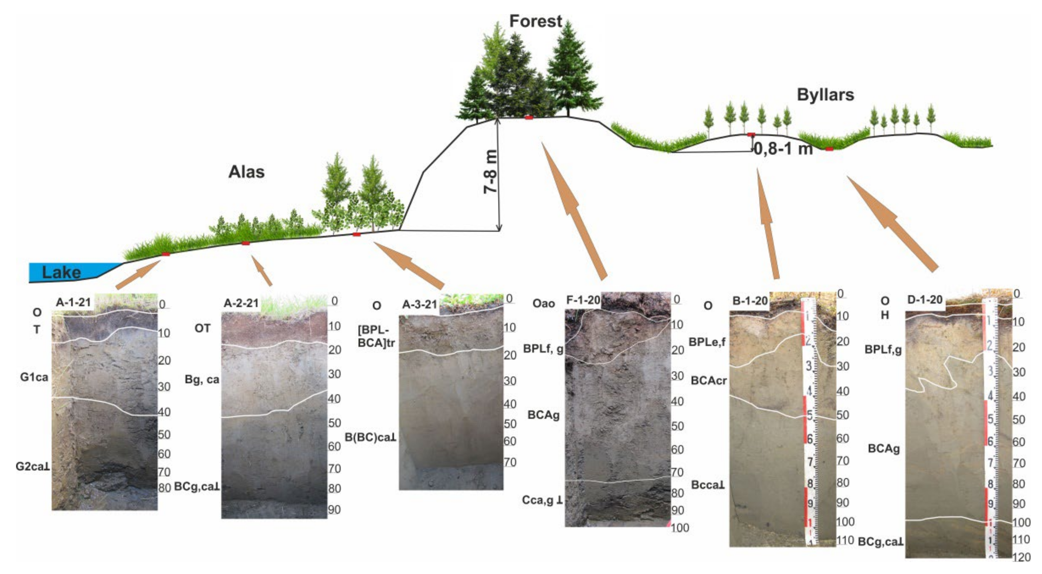
3.1. Site No. 1
3.2. Site No. 2
4. Discussion
5. Conclusions
Author Contributions
Funding
Institutional Review Board Statement
Informed Consent Statement
Data Availability Statement
Acknowledgments
Conflicts of Interest
References
- Streletskiy, D.A.; Sherstiukov, A.B.; Frauenfeld, O.W.; Nelson, F.E. Changes in the 1963–2013 shallow ground thermal regime in Russian permafrost regions. Environ. Res. Lett. 2015, 10, 125005. [Google Scholar] [CrossRef]
- Obu, J.; Westermann, S.; Bartsch, A.; Berdnikov, N.; Christiansen, H.H.; Dashtseren, A.; Delaloye, R.; Elberling, B.; Etzelmuller, B.; Kholodov, A.; et al. Northern Hemisphere permafrost map based on TTOP modelling for 2000–2016 at 1 km2 scale. Earth Sci. Rev. 2019, 193, 299–316. [Google Scholar] [CrossRef]
- Schuur, E.A.G.; McGuire, A.D.; Schädel, C.; Grosse, G.; Harden, J.W.; Hayes, D.J.; Hugelius, G.; Koven, C.D.; Kuhry, P.; Lawrence, D.; et al. Climate change and the permafrost carbon feedback. Nature 2015, 520, 171–179. [Google Scholar] [CrossRef]
- Christensen, T.R.; Rysgaard, S.; Bendtsen, J.; Else, B.; Glud, R.N.; van Huissteden, J.; Parmentier, F.J.W.; Sachs, T.; Vonk, J.E. Arctic carbon cycling. In Snow, Water, Ice and Permafrost in the Arctic (SWIPA); Report of Arctic Monitoring and Assessment Programme (AMAP); Arctic Monitoring and Assessment Programme: Oslo, Norway, 2017; pp. 203–218. [Google Scholar]
- Meredith, M.; Sommerkorn, M.; Cassotta, S.; Derksen, C.; Ekaykin, A.; Hollowed, A.; Kofinas, G.; Mackintosh, A.; Melbourne-Thomas, J.; Muelbert, M.M.C.; et al. Polar Regions. In IPCC Special Report on the Ocean and Cryosphere in a Changing Climate; Portner, H.-O., Roberts, D.C., Masson-Delmotte, V., Zhai, P., Tignor, M., Poloczanska, E., Mintenbeck, K., Alegría, A., Nicolai, M., Okem, A., et al., Eds.; Cambridge University Press: Cambridge, UK; New York, NY, USA, 2019; pp. 203–320. [Google Scholar] [CrossRef]
- Desyatkin, A.; Fedorov, P.; Filippov, N.; Desyatkin, R. Climate change and its influence on the active layer depth in Central Yakutia. Land 2021, 10, 3. [Google Scholar] [CrossRef]
- Kachurin, S.P. Thermokarst in the USSR; Publishing House of AS USSR: Moscow, Russia, 1961; p. 292. (In Russian) [Google Scholar]
- Schirrmeister, L.; Froese, D.; Tumskoy, V.; Grosse, G.; Wetterich, S. Permafrost and Periglacial Features | Yedoma: Late Pleistocene Ice-Rich Syngenetic Permafrost of Beringia. In Encyclopedia of Quaternary Sciences, 2nd ed.; Elias, S.A., Mock, S.J., Eds.; Elsevier: Amsterdam, The Netherlands, 2013; Volume 3, pp. 542–552. [Google Scholar] [CrossRef]
- Strauss, J.; Laboor, S.; Schirrmeister, L.; Fedorov, A.N.; Fortier, D.; Froese, D.; Fuchs, M.; Günther, F.; Grigoriev, M.; Harden, J.; et al. Circum-Arctic Map of the Yedoma Permafrost Domain. Front. Earth Sci. 2021, 9, 758360. [Google Scholar] [CrossRef]
- Grave, N.A. Fossil ice in the watershed of the Lena and Aldan rivers. In Proceedings of the V.A. Obruchev Institute of Permafrost Science; Publishing House of AS USSR: Moscow, Russia, 1944; Volume 4, pp. 10–32. (In Russian). [Google Scholar]
- Soloviev, P.A. Cryolithozone of the Northern Part of the Lena-Amga Interfluve; Publishing House of AS USSR: Moscow, Russia, 1959; p. 144. (In Russian) [Google Scholar]
- Grosse, G.; Robinson, J.E.; Bryant, R.; Taylor, M.D.; Harper, W.; De Masi, A.; Kyker-Snowman, E.; Veremeeva, A.; Schirrmeister, L.; Harden, J. Distribution of late Pleistocene ice-Rich Syngenetic Permafrost of the Yedoma Suite in East and Central Siberia, Russia; U.S. Geological Survey Open File Report; Number 2013–1078; U.S. Geological Survey: Reston, VA, USA, 2013; p. 37. [CrossRef]
- Jorgenson, M.T.; Kanevskiy, M.; Shur, Y.; Moskalenko, N.; Brown, D.R.N.; Wickland, K.; Striegl, R.; Koch, J. Role of ground ice dynamics and ecological feedbacks in recent ice wedge degradation and stabilization. J. Geophys. Res. Earth Surf. 2015, 120, 2280–2297. [Google Scholar] [CrossRef]
- Desyatkin, A.; Takakai, F.; Nikolaeva, M. Landscape microzones within thermokarst depressions of Central Yakutia under present climatic conditions. Geosciences 2018, 8, 439. [Google Scholar] [CrossRef]
- Desyatkin, R.V.; Desyatkin, A.R. The effect of increasing active layer depth on changes in the water budget in the cryolithozone. Eurasian Soil Sci. 2019, 52, 1447–1455. [Google Scholar] [CrossRef]
- Desyatkin, R.V. Soil formation in alases. Eurasian Soil Sci. 1991, 23, 9–19. (In Russian) [Google Scholar]
- Desyatkin, R.V. Syngenetic soil salinization during alas development. Eurasian Soil Sci. 1993, 25, 38–46. [Google Scholar]
- Desyatkin, R.V. Soil Formation in Thermokarst Depressions—Alases of the Cryolithozone; Nauka: Novosibirsk, Russia, 2008; p. 324. (In Russian) [Google Scholar]
- Schuur, E.A.G.; Bockheim, J.; Canadell, J.G.; Euskirchen, E.; Field, C.B.; Goryachkin, S.V.; Hagemann, S.; Kuhry, P.; Lafleur, P.M.; Lee, H.; et al. Vulnerability of permafrost carbon to climate change: Implications for the global carbon cycle. BioScience 2008, 58, 701–714. [Google Scholar] [CrossRef]
- Nitzbon, J.; Westermann, S.; Langer, M.; Martin, L.C.P.; Strauss, J.; Laboor, S.; Boike, J. Fast response of cold ice-rich permafrost in northeast Siberia to a warming climate. Nat. Commun. 2020, 11, 2201. [Google Scholar] [CrossRef]
- Turetsky, M.R.; Jones, M.C.; Anthony, K.W.; Olefeldt, D.; Schuur, E.A.G.; Koven, C.; Mcguire, A.D.; Grosse, G. Permafrost collapse is accelerating carbon release. Nature 2019, 569, 32–34. [Google Scholar] [CrossRef] [PubMed]
- Turetsky, M.R.; Abbott, B.W.; Jones, M.C.; Anthony, K.W.; Olefeldt, D.; Schuur, E.A.G.; Grosse, G.; Kuhry, P.; Hugelius, G.; Koven, C.; et al. Carbon release through abrupt permafrost thaw. Nat. Geosci. 2020, 13, 138–143. [Google Scholar] [CrossRef]
- Jorgenson, M.; Harden, J.; Kanevskiy, M.; O’Donnell, J.; Wickland, K.; Ewing, S.; Manies, K.; Zhuang, Q.; Shur, Y.; Striegl, R.; et al. Reorganization of vegetation, hydrology and soil carbon after permafrost degradation across heterogeneous boreal landscapes. Environ. Res. Lett. 2013, 8, 035017. [Google Scholar] [CrossRef]
- Desyatkin, R.V.; Filippov, N.V.; Desyatkin, A.R.; Konyushkov, D.E.; Goryachkin, S.V. Degradation of Arable Soils in Central Yakutia: Negative Consequences of Global Warming for Yedoma Landscapes. Front. Earth Sci. 2021, 24, 795. [Google Scholar] [CrossRef]
- Osterkamp, T.E.; Jorgenson, M.T.; Schuur, E.A.G.; Shur, Y.L.; Kanevskiy, M.Z.; Vogel, J.G.; Tumskoy, V.E. Physical and ecological changes associated with warming permafrost and thermokarst in Interior Alaska. Permafr. Periglac. Process. 2009, 20, 235–256. [Google Scholar] [CrossRef]
- Jorgenson, M.T.; Romanovsky, V.; Harden, J.; Shur, Y.; O’Donnell, J.; Schuur, E.A.G.; Kanevskiy, M.; Marchenko, S. Resilience and vulnerability of permafrost to climate change. Can. J. For. Res. 2010, 40, 1219–1236. [Google Scholar] [CrossRef]
- Kokelj, S.V.; Jorgenson, M.T. Advances in thermokarst research. Permafr. Periglac. Process. 2013, 24, 108–119. [Google Scholar] [CrossRef]
- Pewe, T.L.; Journaux, A. Origin and Character of Loesslike Silt in Unglaciated South-Central Yakutia, Siberia, USSR; U.S. Government Publishing Office: Washington, DC, USA, 1983; p. 46.
- Chen, Y.; Lara, M.J.; Jones, B.; Frost, G.V.; Hu, F.S. Thermokarst acceleration in Arctic tundra driven by climate change and fire disturbance. One Earth 2021, 4, 1718–1729. [Google Scholar] [CrossRef]
- Shur, Y.L.; Jorgenson, M.T. Patterns of permafrost formation and degradation in relation to climate and ecosystems. Permafr. Periglac. Process. 2007, 18, 7–19. [Google Scholar] [CrossRef]
- Jorgenson, M.T.; Shur, Y.L.; Pullman, E.R. Abrupt increase in permafrost degradation in Arctic Alaska. Geophys. Res. Lett. 2006, 33, 2–5. [Google Scholar] [CrossRef]
- De Groot, W.J.; Cantin, A.S.; Flannigan, M.D.; Soja, A.J.; Gowman, L.M.; Newbery, A. A comparison of Canadian and Russian boreal forest fire regimes. For. Ecol. Manag. 2013, 294, 23–34. [Google Scholar] [CrossRef]
- Jones, B.M.; Grosse, G.; Arp, C.D.; Miller, E.; Liu, L.; Hayes, D.J.; Larsen, C.F. Recent Arctic tundra fire initiates widespread thermokarst development. Sci. Rep. 2015, 5, 15865. [Google Scholar] [CrossRef]
- Kokelj, S.V.; Tunnicliffe, J.; Lacelle, D.; Lantz, T.C.; Chin, K.S.; Fraser, R. Increased precipitation drives mega slump development anddestabilization of ice-rich permafrost terrain, northwestern Canada. Glob. Planet. Chang. 2015, 129, 56–68. [Google Scholar] [CrossRef]
- Liu, Z.; Ballantyne, A.P.; Cooper, L.A. Biophysical feedback of global forest fires on surface temperature. Nat. Commun. 2019, 10, 214. [Google Scholar] [CrossRef]
- Lara, M.J.; Chipman, M.L.; Hu, F.S. Automated detection of thermoerosion in permafrost ecosystems using temporally dense Landsat image stacks. Remote Sens. Environ. 2019, 221, 462–473. [Google Scholar] [CrossRef]
- Holloway, J.E.; Lewkowicz, A.G.; Douglas, T.A.; Li, X.; Turetsky, M.R.; Baltzer, J.L.; Jin, H. Impact of wildfire on permafrost landscapes: A review of recent advances and future prospects. Permafr. Periglac. Process 2020, 31, 371–382. [Google Scholar] [CrossRef]
- Yanagiya, K.; Furuya, M. Post-wildfire surface deformation near Batagay, Eastern Siberia, detected by L-band and C-band InSAR. J. Geophys. Res. Earth Surf. 2020, 125, e2019JF005473. [Google Scholar] [CrossRef]
- Fedorov, A.N. Permafrost Landscape Research in the Northeast of Eurasia. Earth 2022, 3, 460–478. [Google Scholar] [CrossRef]
- Murton, J.B.; Edwards, M.E.; Lozhkin, A.V.; Anderson, P.M.; Savvinov, G.N.; Bakulina, N.; Bondarenko, O.V.; Cherepanova, M.V.; Danilov, P.P.; Boeskorov, V.; et al. Preliminary paleoenvironmental analysis of permafrost deposits at Batagaika megaslump, Yana Uplands, northeast Siberia. Quat. Res. 2017, 87, 314–330. [Google Scholar] [CrossRef]
- Glushkova, O.Y. Late Pleistocene glaciations in North-East Asia. In Quaternary Glaciations—Extent and Chronology. A Closer Look. Developments in Quaternary Science; Ehlers, J., Gibbard, P.L., Hughes, P.D., Eds.; Elsevier: Amsterdam, The Netherlands, 2011; Volume 15, pp. 865–875. [Google Scholar] [CrossRef]
- Morozova, E.A.; Andreev, A.A.; Fedorov, G.V.; Schwamborn, G.; Schirrmeister, L.; Ostanin, N.B. Late Pleistocene and Holocene vegetation history as inferred from palynological investigations of the El’gygytgyn Lake crater permafrost deposits. Her. RAS Geogr. Ser. 2012, 4, 69–82. [Google Scholar] [CrossRef][Green Version]
- Matrosova, T.V. Reconstruction of vegetation and climates in northern Chukotka during the last 350 thousand years (according to palynologic evidences of Elgygytgyn Lake). Bull. North East Sci. Cent. 2009, 2, 23–30. (In Russian) [Google Scholar]
- Lozhkin, A.V.; Anderson, P.M.; Matrosova, T.V.; Minyuk, P.S. The pollen record from El’gygytgyn Lake: Implications for vegetation and climate histories of northern Chukotka since the late middle Pleistocene. J. Paleolimnol. 2007, 37, 135–153. [Google Scholar] [CrossRef]
- Bosikov, N.P. Evolution of the alases of Central Yakutia; Permafrost Institute SB RAS: Yakutsk, Russia, 1991; p. 128. (In Russian) [Google Scholar]
- Katamura, F.; Fukuda, M.; Bosikov, N.P.; Desyatkin, R.V.; Nakamura, T.; Moriizumi, J. Thermokarst formation and vegetation dynamics inferred from a palynological study in Central Yakutia, Eastern Siberia. Arct. Antarct. Alp. Res. 2006, 38, 561–570. [Google Scholar] [CrossRef]
- Desyatkin, R.V. Specific features of soil formation in alas landscapes of the cryolithozone. Her. Russ. Acad. Sci. 2020, 90, 79–87. [Google Scholar] [CrossRef]
- Protopopova, V.V.; Gabysheva, L.P. Inflammbility on the Verkhoyansk forestry (Northeast Yakutia). Adv. Curr. Nat. Sci. 2017, 5, 66–71. (In Russian) [Google Scholar]
- Tomirdiaro, S.V. Late Pleistocene and Holocene loess-ice formation of Eastern Siberia; Nauka: Moscow, Russia, 1980; p. 184. (In Russian) [Google Scholar]
- Tomirdiaro, S.V.; Chernenky, B.I. Cryogenic-Aeolian Deposits of the Eastern Arctic and Subarctic Zones; Nauka: Moscow, Russia, 1987; p. 198. (In Russian) [Google Scholar]
- Geological Map of the North-East of the USSR. 1:1 500,000; GUGK: Leningrad, Russia, 1982. (In Russian)
- Protopopov, P.I.; Trushchelev, A.M.; Protopopov, G.K.; Fedorova, S.S.; Zharikova, L.P.; Budnikov, I.V.; Smetannikova, L.I.; Yuganova, L.A.; Fedorova, S.Y.; Shepelev, N.G. State Geological Map of the Russian Federation. 1:1,000,000; VSEGEI: Saint Petersburg, Russia, 2015. (In Russian) [Google Scholar]
- Shcherbakov, O.I.; Zharikova, L.P. Loessoids of the Verkhoyansk ridge. Bull. Goskomgeol. Mater. Geol. Miner. Repub. Sakha Yakutia 2015, 1, 47–51. (In Russian) [Google Scholar]
- Murzin, Y.A. Thermokarst in the eastern Verkhoyansk mountains. Vestn. North East Fed. Univ. Earth Sci. 2019, 1, 48–54. [Google Scholar] [CrossRef]
- Kunitsky, V.V.; Syromyatnikov, I.I.; Schirrmeister, L.; Skachkov, Y.B.; Grosse, G.; Wetterich, S.; Grigoriev, M.N. Ice-rich permafrost and thermal denudation in the Batagay area (Yana upland, East Siberia). Earths Cryosphere 2013, 17, 56–68. (In Russian) [Google Scholar]
- Vasilchuk, Y.K.; Vasilchuk, J.Y.; Ginzburg, A.P. Cryogenic soils in the area of Batagaika crater in Northern Yakutia. Arct. Antarct. 2020, 3, 52–99. [Google Scholar] [CrossRef]
- Vasilchuk, Y.K.; Vasilchuk, J.Y.; Budantseva, N.A.; Vasilchuk, A.K. Batagai edoma—A unique cryolithological object. In Proceedings of the XIII All-Russian Scientific and Practical Conference and Exposition «Prospects of Development of Engineering Surveys in Construction in the Russian Federation»; Viskhadzhieva, K.S., Ed.; Geomarketing: Moscow, Russia, 2017; Volume 1, pp. 294–304. (In Russian) [Google Scholar]
- Ashastina, K.; Schirrmeister, L.; Fuchs, M.; Kienast, F. Palaeoclimate characteristics in interior Siberia of MIS 6–2: First insights from the Batagay permafrost mega-thaw slump in the Yana Highlands. Clim. Past 2017, 13, 795–818. [Google Scholar] [CrossRef]
- Alisov, B.P. Climate of the USSR; Textbook for University; Moscow University Press: Moscow, Russia, 1956; p. 126. (In Russian) [Google Scholar]
- Weather and Climate. Available online: http://www.pogodaiklimat.ru/history/24263.html (accessed on 12 July 2022).
- Scientific and Applied Reference Book on the Climate of the USSR. Series 3: Long-Term Data; Smirnova, N.S., Ed.; Gidrometeoizdat: Leningrad, Russia, 1989; Volume 24, p. 303. (In Russian) [Google Scholar]
- Shepelev, A.G.; Cherepanova, A.M. Permafrost landscapes of Verkhoyansky district using the example of Batagaysky basin and Kysilyakh range, Northern Yakutia. Mod. Probl. Territ. Dev. 2019, 3, 4. (In Russian) [Google Scholar]
- Andreev, V.N.; Galaktionova, T.F.; Perfilieva, V.I.; Shcherbakov, I.P. The Main Features of the Vegetation Cover of the Yakutian ASSR; Yakutsk Science Centre Publishing House: Yakutsk, Russia, 1987; p. 156. (In Russian) [Google Scholar]
- Yurtsev, B.A. Problems of Botanical Geography in Northeast Asia; Nauka: Leningrad, Russia, 1974; p. 160. (In Russian) [Google Scholar]
- Zaslavskaya, T.M. On the flora of vascular plants of the Upper Yana river basin (Northern Yakutia). Bot. J. 1992, 77, 86–97. (In Russian) [Google Scholar]
- Koroleva, T.M.; Khitun, O.V.; Chinenko, S.V.; Gogoleva, P.A.; Zverev, A.A.; Petrovsky, V.V.; Pospelova, E.B.; Pospelov, I.N. Approaches to floristic subdivision based on similarity of geographical structure and species composition of Northern Yakutian local floras. Bull. Udmurt Univ. Ser. Biol. Earth Sci. 2016, 26, 59–70. (In Russian) [Google Scholar]
- Zakharova, V.I. Rare and endemic plants of the relict steppes of Yakutia. Vestn. North East. Fed. Univ. 2011, 8, 16–22. [Google Scholar]
- Ukraintseva, V.V. Flora of the Late Pleistocene and Holocene in Siberia. Bot. J. 1996, 81, 37–48. (In Russian) [Google Scholar]
- Avetov, N.A.; Aleksandrovskiy, A.L.; Alyabina, I.O.; Ananko, T.V.; Barsova, N.Y.; Biryukov, M.V.; Biryukova, O.N.; Bogatyrev, L.G.; Bogdanov, M.D.; Bulgakov, D.S.; et al. National Soil Atlas of the Russian Federation; Astrel: Moscow, Russia, 2011; p. 631. (In Russian) [Google Scholar]
- Desyatkin, R.V.; Lesovaya, S.N.; Okoneshnikova, M.V.; Ivanova, A.Z. Cryosols from tundra and taiga zones of Yakutia: Properties, clay mineralogy, and problems of classification. Eurasian Soil Sc. 2021, 54, 1783–1794. [Google Scholar] [CrossRef]
- Okoneshnikova, M.V.; Desyatkin, R.V. Soils of northern spurs of the Cherskii Ridge in the area of the northern pole of cold: Morphology, properties, and classification. Eurasian Soil Sci. 2017, 50, 898–906. [Google Scholar] [CrossRef]
- Danilov, I.D. Cryolithozone of the Earth and its zoning. Her. AS USSR Geogr. Ser. 1983, 1, 12–18. (In Russian) [Google Scholar]
- Field Geobotany; Lavrenko, E.M., Korchagina, A.A., Eds.; Nauka: Leningrad, Russia, 1964; Volume 3, p. 531. (In Russian) [Google Scholar]
- Mirkin, B.M.; Naumova, L.G. The Science of Vegetation: History and Current State of Basic Concepts; Gilem: Ufa, Russia, 1998; p. 413. (In Russian) [Google Scholar]
- Kachinskii, N.A. Mechanical and Microaggregate Composition of Soil, Methods of Investigation; Publishing House of AS USSR: Moscow, Russia, 1958; p. 191. (In Russian) [Google Scholar]
- Vorobieva, L.A. Soil Chemical Analysis; Moscow State University Press: Moscow, Russia, 1998; p. 272. (In Russian) [Google Scholar]
- Van Reeuwijk, L.P. Procedures for Soil Analysis. Technical Paper, 6th ed.; FAO/ISRIC: Wageningen, The Netherlands, 2002; Number 9; p. 120. [Google Scholar]
- Shishov, L.L.; Tonkonogov, V.D.; Lebedeva, I.I.; Gerasimova, M.I. Classification and Diagnostics of Soils of Russia; Oikumena: Smolensk, Russia, 2004; p. 341. (In Russian) [Google Scholar]
- IUSS Working Group WRB. World Reference base for soil resources 2014, update 2015 International soil classification system for naming soils and creating legends for soil maps, update 2015. In World Soil Resources Reports; FAO: Rome, Italy, 2015; Number 106; p. 192. [Google Scholar]
- Hammer, O.; Harper, D.A.T.; Ryan, P.D. PAST: Paleontological statistics software package for education and data analysis. Palaeontol. Electron. 2001, 4, 9. [Google Scholar]
- Numerical Palaeobiology: Computer-Based Modelling and Analysis of Fossils and Their Distributions; Harper, D.A.T., Ed.; John Wiley & Sons: Chichester, UK; New York, NY, USA; Weinheim, Germany; Brisbane, Australia; Singapore; Toronto, ON, Canada, 1999; p. x+468. [Google Scholar]
- Zolnikov, V.G. Soils of the eastern half of Central Yakutia and their use. In Materials on Natural Conditions and Agriculture in Central Yakutia; Dadykin, V.P., Belousov, S.A., Eds.; Publishing House of AS USSR: Moscow, Russia, 1954; Volume 1, pp. 55–221. (In Russian) [Google Scholar]
- Pozdnyakov, L.K. Forest on Permafrost; Nauka: Novosibirsk, Russia, 1983; p. 96. (In Russian) [Google Scholar]
- Pozdnyakov, L.K. Permafrost Forest Science; Nauka: Novosibirsk, Russia, 1986; p. 192. (In Russian) [Google Scholar]


| Profile No. | Tree Layer | Shrub Layer | Dwarf Shrub Layer | Herbaceous and Moss-Lichen Layers |
|---|---|---|---|---|
| Forest Site (No. 1) | ||||
| F-1-20 (forest) | Larix cajanderi | - | Ledum palustre, Vaccinium vitis-idaea | Arctous alpina, Empetrum nigrum, Chamerion angustifolium, Calamogrostis langsdorffii, Anemone sylvestris, Equisetum arvense, Phlox sibirica, Bromopsis karavaevii, Lathyrus humilis |
| B-1-20 (top of byllar) | Larix cajanderi | Betula divaricata, Salix bebbiana | Vaccinium vitis-idaea | Arctous alpina Aulacomnium turgidum |
| D-1-20 (depression between byllars) | - | Salix bebbiana | - | Carex juncella, Chamerion angustifolium, Calamogrostis langsdorffii Aulacomnium turgidum |
| Alas Site (No. 2) | ||||
| A-1-21 (meadow) | - | - | - | Carex juncella, Calamogrostis lapponica, Alopecurus roshevitzianus, Eriophorum angustifolium, Petasites frigidus, Ranunculus propinquus, Potentilla nivea, Dreponacladus aduncus |
| A-2-21 (meadow) | - | Betula nana, Salix brachypoda | - | Carex juncella, Rubus arcticus, Valeriana capitata, Polemonium acutiflorum, Acrtagrostis latifolia, Bromopsis karavaevii, Poa angustifolia, Aegopodium alpestre, Potentilla stipularis, Ranunculus propinquus, Veronica longifolia, Petasites frigidus, Potentilla nivea, Halenia corniculata, Stellaria kolymensis, Dreponacladus aduncus |
| A-3-21 (shrubs) | Larix cajanderi | Betula nana, Salix brachypoda | - | Arctous erytrocarpa, Carex juncella, Anemone sylvestris Peltigera aphthosa, Aulacomnium turgidum |
| Tree and Shrub Layers | Crown Density Index | Tree Stand Formulas | D (1.3) (cm) | H (д) (м) | Age Class |
|---|---|---|---|---|---|
| Larch forest herb. (F-1-20) | |||||
| Maturing tree stand | 0.7 | 10 L | 10 cm | 8 | III |
| Young growth | 0.2 | 10 L | 5 cm | 2 | I |
| Undergrowth | - | - | - | - | - |
| Larch forest moss-vaccinium vitis-idaea (B-1-20) | |||||
| Young forest growth | 0.1 | 10 L | 5 | 3 | I |
| Youngester | 0.8 | 10 L | 3 | 0.75 | I |
| Undergrowth | 0.2 | 3B2S | 1.5 | 0.5 | I |
| Profile No. | Depth, cm | Bulk Density | Particle Size (%), mm | Sum of Particles, <0.01 mm | |||||
|---|---|---|---|---|---|---|---|---|---|
| 1–0.25 | 0.25–0.05 | 0.05–0.01 | 0.01–0.005 | 0.005–0.001 | <0.001 | ||||
| Forest soils (Site No 1) | |||||||||
| F-1-20 (forest) | 3–7 | 2.65 | 1.3 | 33.3 | 36.8 | 4.9 | 8.9 | 14.8 | 28.6 |
| 7–70 | 2.66 | 0.8 | 34.2 | 43.7 | 14.7 | 1.2 | 5.4 | 21.3 | |
| 70–97 | 2.63 | 0.9 | 33.7 | 43.7 | 8.2 | 10.6 | 2.9 | 21.7 | |
| B-1-20 (top of byllar) | 4–15 | 2.66 | 1.8 | 41 | 33.9 | 3.6 | 10.6 | 9.1 | 23.3 |
| 15–42 | 2.66 | 1.9 | 45.4 | 32.2 | 4.9 | 8.2 | 7.4 | 20.5 | |
| 42–105 | 2.68 | 2.6 | 50.8 | 26.9 | 4.1 | 7.8 | 7.8 | 19.7 | |
| D-1-20 (depression between byllars) | 5–20 | 2.67 | 2.8 | 42.9 | 35 | 6.2 | 7.3 | 5.8 | 19.3 |
| 20–98 | 2.68 | 1.3 | 35.8 | 41.2 | 6.1 | 8.2 | 7.4 | 21.7 | |
| 98–105 | 2.68 | 2.9 | 42.3 | 31.9 | 5.3 | 9.4 | 8.2 | 22.9 | |
| Alas soils (Site No 2) | |||||||||
| A-1-21 (meadow) | 7(11)–30(40) | 0.65 | 0.9 | 7.5 | 64.8 | 6.8 | 11.2 | 8.8 | 26.8 |
| 30(40)–80 | 2.66 | 0.4 | 39.5 | 48.6 | 2.4 | 4.5 | 4.6 | 11.5 | |
| A-2-21 (meadow) | 13(15)–35(45) | 2.64 | 0.8 | 12.4 | 56.8 | 10.4 | 8.4 | 11.2 | 30 |
| 35(45)–87 | 2.65 | 0.5 | 36.3 | 46 | 5.6 | 3.6 | 8 | 17.2 | |
| A-3-21 (shrubs) | 1(2)–15(18) | 2.61 | 3.7 | 15.1 | 41.2 | 11.2 | 15.2 | 13.6 | 40 |
| 15(18)–68 | 2.66 | 0.1 | 39.8 | 45.3 | 3.3 | 4.9 | 6.6 | 14.8 | |
| Profile No | Depth, cm | pH (H2O) | Corg, % | Exchangeable Cations, mmoL/100 g | HA, mmoL/100 g | Sum of Salts, % | Moisture, % | ||
|---|---|---|---|---|---|---|---|---|---|
| Ca2+ | Mg2+ | Na+ | |||||||
| Forest soils (Site No 1) | |||||||||
| F-1-20 (forest) | 0–3 | 5.98 | 36.05 * | - | - | - | 20.4 | - | |
| 3–7 | 6.68 | 1.18 | 9.44 | 3.84 | 0.09 | 1.56 | 0.091 | 22.9 | |
| 7–70 | 8.41 | 0.57 | 8.64 | 1.28 | 0.08 | - | 0.089 | 21.2 | |
| 70–97 | 8.07 | 1.07 | 8.8 | 2.08 | 0.07 | - | 0.09 | 27.6 | |
| B-1-20 (top of byllar) | 0–4 | 5.91 | 53.36 * | - | - | - | 22.4 | - | - |
| 4–15 | 6.58 | 0.56 | 8.16 | 2.56 | 0.08 | 1.13 | 0.059 | 12.1 | |
| 15–42 | 8.14 | 0.59 | 8 | 2.24 | 0.09 | - | 0.096 | 10.3 | |
| 42–105 | 8.36 | 0.52 | 7.04 | 1.28 | 0.07 | - | 0.084 | 11.6 | |
| D-1-20 (depression between byllars) | 2–5 | 6.27 | 42.14 * | - | - | - | 16.7 | - | - |
| 5–20 | 6.56 | 0.87 | 7.75 | 2.38 | 0.08 | 1.46 | 0.056 | 20.1 | |
| 20–98 | 8.3 | 0.47 | 8 | 0.88 | 0 | - | 0.084 | 16.5 | |
| 98–115 | 8.11 | 0.57 | 9.13 | 1.12 | 0.04 | - | 0.092 | 17.6 | |
| Alas soils (Site No 2) | |||||||||
| A-1-21 (meadow) | 2–7(11) | 7.84 | 72.14 * | - | - | - | - | - | - |
| 7(11)–30(40) | 8.25 | 1.13 | 8.48 | 4.64 | 0.33 | - | 0.217 | 42.2 | |
| 30(40)–80 | 8.29 | 0.77 | 4.96 | 3.52 | 0.12 | - | 0.151 | 34 | |
| A-2-21 (meadow) | 0–13(15) | 6.2 | 82.35 * | - | - | - | - | - | 106,3 |
| 13(15)–35(45) | 8.1 | 1.31 | 5.92 | 4.8 | 0.2 | - | 0.143 | 25.5 | |
| 35(45)–87 | 8.23 | 1.02 | 5.76 | 2.72 | 0.14 | - | 0.129 | 29.9 | |
| A-3-21 (shrubs) | 0–1(2) | 6.58 | 43.14 * | - | - | - | - | - | 41.3 |
| 1(2)–15(18) | 8.27 | 2.19 | 9.25 | 4.25 | - | - | - | 28.8 | |
| 15(18)–68 | 8.41 | 0.74 | 6.24 | 2.08 | 0.1 | - | 0.102 | 16.5 | |
| Species | Projective Cover by Brown-Blanque Cover Class | H (cm) | Phenophase |
|---|---|---|---|
| Dwarf birch thicket | |||
| Arctous erytrocarpa | 2 * | 10 | ~ ** |
| Carex juncella | r | 20 | ~ |
| Anemone sylvestris | r | 25 | v |
| Sedge-tussock meadow | |||
| Carex juncella | 3 | 25 | ~ |
| Rubus arcticus | 2 | 20 | ~ |
| Valeriana capitata | 1 | 30 | v |
| Polemonium acutiflorum | 1 | 25 | v |
| Acrtagrostis latifolia | 1 | 55 | v |
| Bromopsis karavaevii | 1 | 30 | ~ |
| Poa angustifolia | 1 | 30 | ~ |
| Aegopodium alpestre | + | 25 | v |
| Potentilla stipularis | + | 20 | ~ |
| Ranunculus propinquus | + | 25 | ~ |
| Veronica longifolia | + | 25 | v |
| Petasites frigidus | + | 20 | ~ |
| Potentilla nivea | + | 30 | ~ |
| Halenia corniculata | r | 25 | v |
| Stellaria kolymensis | r | 15 | v |
| Cottongrass-reed-sedge meadow | |||
| Carex juncella | 4 | 28 | ~ |
| Calamogrostis lapponica, | 3 | 45 | ~ |
| Alopecurus roshevitzianus | 2 | 40 | ~ |
| Petasites frigidus | 2 | 25 | ~ |
| Eriophorum angustifolium | 1 | 35 | # |
| Ranunculus propinquus | 1 | 25 | ~ |
| Potentilla nivea | 1 | 35 | ~ |
Publisher’s Note: MDPI stays neutral with regard to jurisdictional claims in published maps and institutional affiliations. |
© 2022 by the authors. Licensee MDPI, Basel, Switzerland. This article is an open access article distributed under the terms and conditions of the Creative Commons Attribution (CC BY) license (https://creativecommons.org/licenses/by/4.0/).
Share and Cite
Desyatkin, R.; Okoneshnikova, M.; Ivanova, A.; Nikolaeva, M.; Filippov, N.; Desyatkin, A. Dynamics of Vegetation and Soil Cover of Pyrogenically Disturbed Areas of the Northern Taiga under Conditions of Thermokarst Development and Climate Warming. Land 2022, 11, 1594. https://doi.org/10.3390/land11091594
Desyatkin R, Okoneshnikova M, Ivanova A, Nikolaeva M, Filippov N, Desyatkin A. Dynamics of Vegetation and Soil Cover of Pyrogenically Disturbed Areas of the Northern Taiga under Conditions of Thermokarst Development and Climate Warming. Land. 2022; 11(9):1594. https://doi.org/10.3390/land11091594
Chicago/Turabian StyleDesyatkin, Roman, Matrena Okoneshnikova, Alexandra Ivanova, Maya Nikolaeva, Nikolay Filippov, and Alexey Desyatkin. 2022. "Dynamics of Vegetation and Soil Cover of Pyrogenically Disturbed Areas of the Northern Taiga under Conditions of Thermokarst Development and Climate Warming" Land 11, no. 9: 1594. https://doi.org/10.3390/land11091594
APA StyleDesyatkin, R., Okoneshnikova, M., Ivanova, A., Nikolaeva, M., Filippov, N., & Desyatkin, A. (2022). Dynamics of Vegetation and Soil Cover of Pyrogenically Disturbed Areas of the Northern Taiga under Conditions of Thermokarst Development and Climate Warming. Land, 11(9), 1594. https://doi.org/10.3390/land11091594