Article

Understanding the Accessibility of Urban Parks and Connectivity of Green Spaces in Single-Person Household Distribution: Case Study of Incheon, South Korea

Department of Urban Policy & Administration, Incheon National University, Incheon 22012, Korea
*
Author to whom correspondence should be addressed.
Land 2022, 11(9), 1441; https://doi.org/10.3390/land11091441
Submission received: 25 July 2022 / Revised: 19 August 2022 / Accepted: 26 August 2022 / Published: 31 August 2022
(This article belongs to the Section Urban Contexts and Urban-Rural Interactions)

Abstract

:
Given the rapidly increasing need for policies with regard to single-person households in Korea, this study examines the effects of park accessibility and the connectivity of green spaces on the spatial distribution of single-person households. SK-Tmap API and Conefor 2.6 are used to analyze park accessibility and green space connectivity, respectively. Multiple and spatial regression analyses are conducted using variables for the following three characteristics: park and green space, housing, and region. The findings show that generalized Betweenness Centrality–Integral Index of Connectivity based index (dBC_IIC), apartments, studio apartments, housings larger than 85 m2, distance to welfare facilities, and population density had a positive association with the spatial distribution of single-person households, while park accessibility, difference in Number of Links (dNL), generalized Betweenness Centrality–Probability of Connectivity based index (dBC_PC), and housing sale prices had a negative relationship. Regression analyses are further conducted for different age groups (10–20 years, 30–50 years, and over 60 years). In terms of park connectivity, dBC_PC showed a negative effect and dBC_IIC had a positive effect for the 10–20 age groups, while the 30–50 age group showed the same result as that of all single-person households. For single-person households over 60 years of age, no connectivity index was found to be significant. Policy implications are made in the short- and mid- to long-term for strengthening the connectivity of parks and green spaces in the study area. The results of this study can be used as an important guideline for establishing park and green space plans in consideration of single-person households in the future.

1. Introduction

According to the Statistics Bureau of Korea [1], the Korean society has experienced dramatic changes in household type, most prominently an increase in single-person (one-person) households. In Korea, single-person households accounted for about 31.7% of total households by type in 2020 [2]. Considering that the number of single-person households is steadily increasing in many developed countries globally, with many experiencing this phenomenon before Korea, this trend is expected to continue; thus, the establishment of related policies are necessary [3,4]. There is a need for customized policies considering the rising proportion of single-person households and current policies in Korea are substantially limited [5]. In response, local governments have begun increasing their related support policies and services. The most representative case being the “Seoul Metropolitan City’s Single-person Household Portal”, which was made available in 2021 to provide information on policies supporting single-person households. The Seoul Metropolitan Government was the first nationwide to enact an ordinance on supporting single-person households [6]. While the enactment of an ordinance—the basis for enforcing a policy—is essential to implement related policies, the City of Incheon is the only one among the special and metropolitan cities in Korea that does not have sufficient ordinance supporting single-person households.
Single-person households tend to be more densely concentrated than multi-person households, and various factors are considered while choosing a residence. Since these factors differ by age group, many studies have been conducted to identify the factors that bring single-person households together. Although factors such as social economy, housing, and convenience facilities were derived through previous research [7,8,9,10], this study focuses on parks and green spaces.
Park et al. [11] confirmed that, since the outbreak of COVID-19, the number of users of neighborhood parks in several districts within Seoul, has increased by 3–6% due to the spread of the pandemic and the implementation of social distancing. In a self-survey conducted on users of a real-estate mobile application [12,13], the importance of parks and green spaces was emphasized, as the respondents answered that park districts and amenities were two of the most important factors when choosing a residential space after the outbreak of the pandemic. In another study, Park et al. [14] identified that since infectious diseases generally originate from wild animals, the risk of settlement in the city can be reduced by preserving habitats that strengthen ecological connectivity. Taken together, city parks and green spaces, which can serve as a habitat for wild animals, are important and are expected to have a positive effect on the spatial distribution of single-person households. Therefore, this study measures ecological connectivity and identifies whether park accessibility and the connectivity of green spaces have a positive effect on the distribution of single-person households. Single-person households are also analyzed by three age groups to identify whether the findings differ by each age group. On the basis of the results, short-term and mid- to long-term green space connectivity enforcement plans as well as suggestions for future green infrastructure policies were presented in consideration of single-person households.

2. Theoretical Consideration and Review of Previous Research

2.1. Parks and Green Areas Master Plan

In general, parks and green spaces are areas that create a pleasant urban environment and contribute to citizens’ relaxation and emotional development. The Act on Urban Parks and Green Areas in Korea, comprises two categories: (1) urban parks, green areas, recreation areas, and vegetation (trees and flowers) areas, and (2) green roofs and walls [15]. Parks and green spaces perform various functions, such as maintaining the urban ecosystem [16], improving environmental and physical health [17], enhancing social inclusion [18], and providing disaster prevention functions [19]. In Korea, the “Parks and Green Areas Master Plan” comprehensively presents the management and expansion of parks/green spaces that play an important function. The plan both guides and presents factual bases, goals and implementation strategies, and recently the “2030 Parks and Green Areas Master Plan” was established for Incheon. The plan proposes various types of green corridors, such as the East–West green axis and the Y-shaped green axis, centering around Incheon City’s core green corridor (S-shaped), as well as the green network, which prioritizes the construction of long-term unexecuted parks, and the blue network, creating a river-centered waterfront space [20].

2.2. Park Accessibility

Studies that have examined the accessibility of park can be classified according to the method of analysis, such as buffer analysis, network analysis, and utilizing APIs. Using buffer analysis, Lim et al. [21] classified 45 administrative districts (dongs) in the City of Seongnam, Korea, into either a vulnerable group or a control group and compared their accessibility to natural green areas and urban parks. The results showed higher accessibility in the control group compared to the vulnerable group. Through a comparative experiment, Cho and Lee [22] identified the service distance of elderly-friendly parks by deriving the walking time by age group based on a 500 m service distance from the neighborhood friendly parks in neighborhood units. The results showed that the elderly took about 1.7 times more walking time than young adults and the middle-aged, indicating that a 300 m service distance will be appropriate for elderly-friendly parks.
Through network analysis, Lee [23] identified the service areas of urban parks and the population ratio within the service areas of the administrative districts of Suwon and suggested that urban parks should be expanded in the old urban center. Seo [24] compared the accessibility of urban parks and green spaces in Dongtan (77.5% urban parks, 95.5% park and green areas), a first-generation new town in Korea, and Pangyo (79.03% urban parks, 94.01% park and green areas), a second-generation new town. The results showed that, similar to Dongtan, a uniform distribution of parks and green areas centering around urban parks is more effective in terms of accessibility. Utilizing API, Kwon [25] analyzed the ecological perspectives and accessibility considering the minimum cost distance of urban green areas, including urban parks in Daegu, and suggested measures to improve the function of green networks. The results showed that large green areas have excellent accessibility, and the function of green networks can be enhanced by expanding the number of residential gardens and school forests.
Previous research related to park accessibility has primarily used buffer and network analysis, which have failed to derive realistic accessibility; in contrast, analysis using API derives the accessibility through the inclusion of travel time, reflecting real-time traffic information, and walking constraints such as stairs and ramps. However, related studies have not been actively conducted [6,26]. Therefore, this study contributes meaningfully in its derivation of park accessibility regarding actual pedestrians with the support of the SK-Tmap API.

2.3. Green Space Connectivity

Conefor 2.6 is a network analysis program that identifies the impact of the links necessary for maintaining and improving landscape (habitat) connections and land changes on connectivity. The program objectively and quantitatively shows the degree of connection between nodes connected through links and provides structural and functional connectivity indices [27]. The structural connectivity index describes simple spatial distributions using the area and distance of landscape and habitat, and includes the Number of Links (NL), Number of Components (NC), Harary Index (H), Betweenness Centrality (BC), Landscape Coincidence Probability (LCP), and Integral Index of Connectivity (IIC). However, since the structural connectivity index does not reflect the mobility of animals in the landscape, a complementary index—the functional connectivity index—is also used. The functional connectivity index considers the mobility of animals and includes the Flux Index (F), Area-Weighted Flux (AWF), and Probability of Connectivity (PC) [28,29,30,31].
Studies that have analyzed the connectivity of parks and green areas can be classified according to the modeling programs used, such as Conefor, APACK, Linkage Mapper, and FRAGSTATS. Using Conefor, Ahn et al. [32] prioritized the unexecuted parks in the City of Seongnam by identifying their degree of contribution to green connectivity. The results showed that unexecuted parks connecting the southwest and northeast of Seongnam, a region discontinued by the Seoul Ring Expressway and Gyeongbu Expressway, are the most important. Other studies have also evaluated the existing greenery connectivity by using Conefor and determined specific parks that play an important role in enhancing the overall city green axes [33,34].
Utilizing APACK, Ahn et al. [35] evaluated and derived measures to increase green connectivity in Seoul, revealing that green areas in Seoul have a relatively uniform shape and that the restoration and greening of rivers and streams are crucial for increasing urban green connectivity. Employing Linkage Mapper, Kwon et al. [36] offered direction for the Parks and Green Areas Master Plan by assessing the green connectivity of Daegu. The results showed that the average value of the lineal distance was about 1.16 km, and the minimum cost distance increased by about 3.59 km on average. In addition, the North–South connectivity was weaker than the East–West in terms of the connectivity of urban parks in the study area. Using FRAGSTATS, Kang et al. [37] analyzed the effects of the ecological network initiated by the 2020 urban park sunset regulation in Busan and provided the best scenario for enhancement of the existing green networks.

2.4. Factors Affecting the Distribution of Single-Person Households

Studies that analyze the factors affecting the distribution of single-person households can be divided into those conducted on total single-person households and those examining only specific age groups or genders. First, Chae et al. [3] conducted a study on all single-person households by identifying the spatially concentrated areas and concentration factors of single-person households in Seoul. While the districts of Gwanak-gu and Gangnam-gu were identified as concentrated areas, the number of KOSDAQ-listed companies, rental houses, small houses of 40–60 m2, and tiny houses below 20 m2 were found to be significant factors for concentration. Moon and Song [5] identified the relationship between satisfaction and quality of life according to the living infrastructure distribution in Seoul. They found that single-person households were concentrated around university districts, convenient transportation, convenient facilities, and welfare facilities. The study also confirmed that the higher the satisfaction with parks and green spaces, public facilities, walking environment, residential environment, and economic environment, the higher the quality of life.
Regarding studies on specific ages and genders, Kim [38] conducted a study on young, single-person households by identifying their residential distribution in Seoul and the factors affecting their distribution, including housing, convenience, and accessibility. The results indicated that the ratio of multi-family and multi-unit housing, the ratio of residences other than housing, and the area of green facilities per person were positively related, while housing sales prices and the distance to central business districts (Gangnam and Yeouido) showed a negative relationship. Kim and Joo [39] identified the concentration factors for young and elderly single-person households in Jinju, Korea. Young, single-person households showed a positive relationship with houses below 40 m2, sports facilities, and retail stores. In contrast, elderly single-person households had a positive relationship with houses over 30-years-old and clinics and a negative relationship with sports facilities and retailers. Lee and Lim [6] examined the distribution status of female and male single-person households in Seoul and analyzed the impacting factors. Female single-person households mainly resided in areas where subway lines 3, 5, 6, and 7 passed through east of the city center, while male single-person households mainly lived in areas where subway lines 2 and 5 passed through and areas near urban highways east of the city center. As for concentration factors, female single-person households showed a negative relationship with accessibility to universities, sports facilities, and community facilities and a positive relationship with the number of tertiary industry businesses and crime prevention CCTVs. In contrast, male single-person households showed a negative relationship with apartment sales prices and accessibility to universities, sports facilities, and community facilities, while a positive relationship has been shown with the number of tertiary industry businesses and cultural facility accessibility.
Previous studies on the factors affecting the distribution of single-person households are limited to the park area, number of parks, and park accessibility and are generally focused on Seoul. These limitations indicate the need to consider the variables of park and green space connectivity along with ecological aspects. In addition, it is necessary to analyze the distribution type and factors of single-person households in other regions. This study bears significance in that it considers the connectivity of parks and green spaces as a variable and Incheon as the target area.

3. Materials and Methods
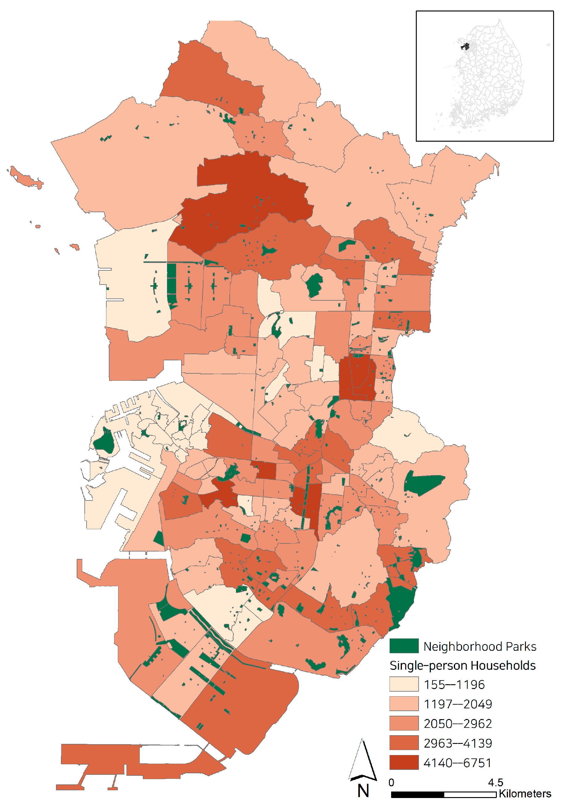
3.1. Study Area

Single-person households and neighborhood parks were selected from the inland areas of eight boroughs (“gu” in Korean) among the administrative districts of Incheon (Gyeyang-gu, Namdong-gu, Dong-gu, Michuhol-gu, Bupyeong-gu, Seo-gu, Yeonsu-gu, and Jung-gu). The 2020 Population and Housing Census (total-household) conducted by Microdata Integrated Service (MDIS) was used to obtain single-person households, and the shapefile of the “2020 Incheon Metropolitan City Administrative District Boundary for Census” by the Statistical Geographic Information Service (SGIS) was used to visualize single-person households by administrative district (dong) units. Neighborhood parks that contributed to improving citizens’ quality of life were selected for analysis. The shapefile, “Road Name Address Background Map”, provided by the Road Name Address Developer Center, and the CSV file, “National Urban Park Information Standard Data,” provided by Open Data Portal, were used. However, since 2020 was selected as the time period, parks built after 2021 were not included in the study, and parks in contact with mountain areas, such as Incheon Grand Park, were excluded. Finally, a total of 127 districts were chosen as study sample and the target of analysis was derived as shown in Figure 1.

3.2. Data Analysis

The analysis was conducted as follows. First, park accessibility and the connectivity of green spaces were derived using SK-Tmap API and Conefor 2.6. Multiple regression and spatial regression analyses were then conducted using 23 variables for the following three characteristics: park and green space, housing, and region.

3.2.1. Park Accessibility Analysis

Unlike other platforms that provide API services, such as Google, SKT-map API provides walking time and walking distance information free of charge. To use the service, the departure points and destination coordinates are required. In this study, the coordinates of the residential areas were set as the departure point and the center point of the nearest park from the residential area was set as the destination. The “Near” function of ArcGIS was used to locate the nearest park. For the coordinates of the residential area, “Road Name Address Electronic Map”, which signify buildings and the entrance to buildings, were utilized. Among building types, only single-family housings, multi-family housings, apartments, townhouses, and multiplex houses were selected, and the coordinates of the entrance to these buildings were used. In the case of parks, the coordinates of the center point of the park from the National Urban Park Information Standard Data were used. A total of 90,549 coordinates for residential area entrances were derived. Finally, the required walking time (unit: seconds) from the departure point to the destination was employed as a variable for park accessibility.

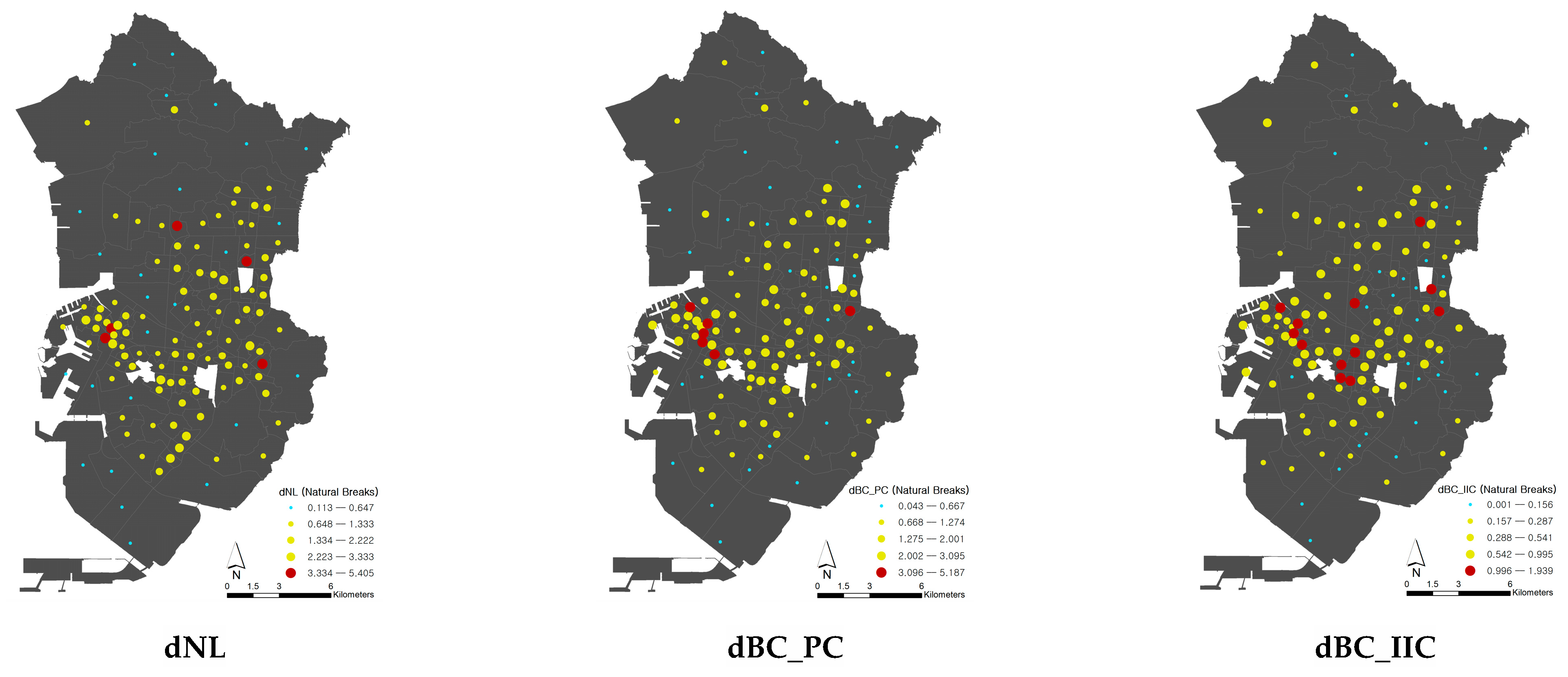
3.2.2. Green Space Connectivity Analysis

For the connectivity of green spaces, those with a Normalized Difference Vegetation Index (NDVI) value of 0.3 or higher were identified using the satellite image of the Earth Observation System [40,41,42]. After using the “Forest Site Soil Map Data” provided by Korea Forest Service to exclude mountain areas, six indices were derived using Conefer 2.6: dNL, dBC, dBC_PC, dBC_IIC, dIICflux, dIICconnector. A lower case “d” before each index denotes an abbreviation of “difference,” which is used to indicate the value of the connectivity index of a certain node [43]. The index NL refers to the number of links to which the node is connected, and BC indicates the node’s degree of performance as a stepping stone in connecting the entire landscape by identifying the frequency at which the node is used as the shortest path. BC_PC and BC_IIC are indices that find more ecologically important nodes by considering the patch area (IIC-based) and maximum spread probability (PC-based), as well as the number of links to supplement BC, which considers only the shortest path [44]. IICflux and IICconnector supplement IIC, which has a limitation in analyzing the exact connectivity for large area differences between nodes. IICflux considers the spread probability of wild animals within an area, and IICconnector measures connectivity by considering the geographical location [45]. The calculation formula for each index is shown in Table 1 [44].

3.2.3. Multiple and Spatial Regression Analyses

To identify factors affecting the distribution of single-person households, a multiple regression analysis was first conducted. As mentioned, the variables derived after reviewing previous studies were divided into three characteristics, and were calculated based on Equation (1), as shown below.
Y = α + β 1 X 1 + β 2 X 2 + β 3 X 3 + e i   ,
where α refers to the constant, βi are the regression coefficients, X1 corresponds to the park/green space characteristics, X2 refers to the housing features, X3 refers to the regional characteristics, and ei is the error term.
Due to the limited number of samples (n = 127), step-wise regression analysis, which has been often used in the prior studies [46,47,48] to alleviate each variable’s impact on the validity of statistical conclusion, were conducted by classifying the variables into three block groups (characteristics). Specifically, Model 1 only included the features of parks and green spaces, and Models 2 and 3 included housing and regional characteristics, respectively. Finally, only statistically significant variables in each model were contained in the fully specified model (Model 4).
Meanwhile, the spatial data, such as the single-person households in administrative district units used in this study, are likely to cause errors in deriving the results due to spatial dependence [49]. Therefore, a spatial regression analysis model was used to increase the reliability of the analysis. In this study, the spatial error model (SEM) was employed, which was calculated through Equation (2) [50,51].
Y = X + μ , μ = λ W μ + ε ,
where β refers to the parameter estimated from the independent variable, μ indicates the residual, and W shows the spatial weight matrix. In addition, λ represents the coefficient of the μ residual processed through the spatial weight matrix, and ε refers to the error term. Since the model derived with a low AIC value is the most suitable, the AIC values of the multiple regression model and the SEM were compared, and R-squares were used to compare the explanatory power of the model [7].

3.2.4. Setting Variables
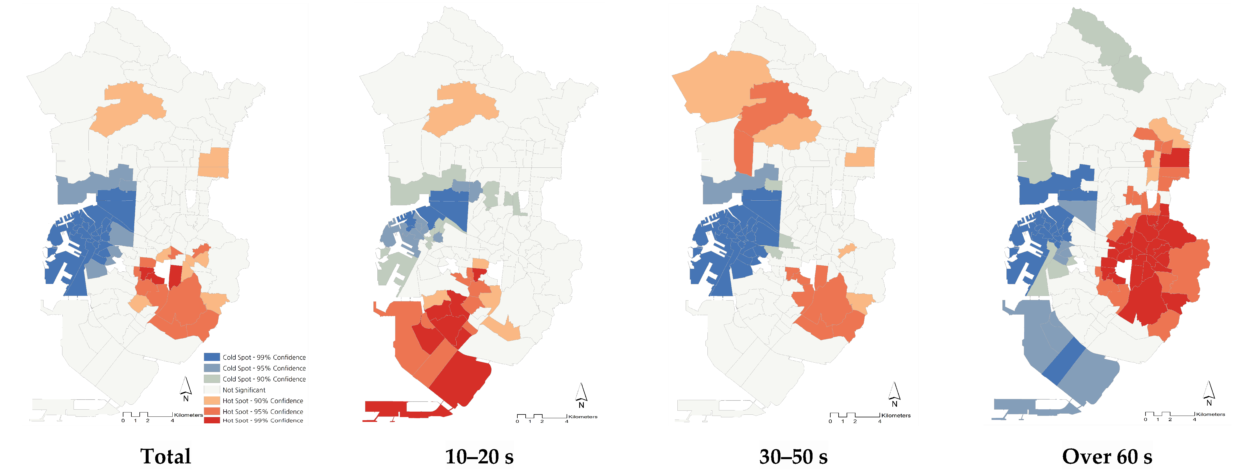
First, the number of single-person households in 127 administrative districts, excluding three identified as abnormal values in the data collection process, was set as the dependent variable. Moran’s I of single-person households was checked and spatial self-correlation was confirmed with a 0.254 value. To analyze the factors with different effects on each age group, the population was classified into the following age groups: 10–20 s, 30–50 s, and over 60 s, as in previous studies [52].
Regarding parks and green spaces, park size, the distance between neighborhood parks, as well as park accessibility and green space connectivity were selected as the independent variables. With regard to housing features, the sales price and monthly rent for which the actual transaction of different housings (apartments, detached/multi-family houses, town/multiplex houses, and studio apartments) that was finalized in 2020 were calculated. Furthermore, using data from the 2020 Population and Housing Census, housing types and the total floor area of housings were considered as variables. Among the total floor areas, housing size larger than 85 m2 was used as a key criterion in this study since 85 m2 has been continuously used as a standard of the medium-sized national houses since the 1970s in Korea [53]. When the Housing Construction Promotion Act was established in 1972, the minimum residential area per person was about 16.7 m2, and since the average number of households at that time was 5, the minimum medium-sized housing unit per household was approximately 85 m2. This standard was constantly used as basis for various housing-related policies in Korea, after the 1970s.
Finally, regarding regional characteristics, accessibility to living infrastructure facilities, such as police stations, universities, medical facilities, welfare facilities, and subway stations, was used as a variable, as in previous studies, while the distance to fire stations was added for safety consideration. Moreover, population density, the number of businesses, and the entropy index-which shows the complexity of land use-were included as variables representing the regional characteristics.

4. Results

4.1. Descriptive Statistics

The descriptive statistics of the dependent and independent variables are shown in Table 2. Regarding single-person households, the average number per each district (dong) was 2193. While Yonghyeon 5-dong (within Michuhol-gu) had the largest number, at 4970, Songnim 1-dong (within Dong-gu) had the smallest number, at 158. The areas where single-person households are densely concentrated were confirmed through a hotspot analysis that visualizes the degree of concentration (Figure 2). The total single-person households are densely residing in the southeast area (Namdong-gu; the original downtown areas with large industrial complexes) of Incheon, while the west areas (Jung-gu and Dong-gu) are shown as cold spots. The 10–20 age group were concentrated in the southwest areas (Yeonsu-gu and Michuhol-gu) of Incheon, where new towns and universities are recently developed. The 30–50 age group were likely to live concentratedly in the northwest (Seo-gu) and southeast region (Namdong-gu). Cold spots were shown similar to that of the total single-person households. Those over 60 were distributed densely in traditional downtown areas on the east side of Incheon, which include Bupyeong and Namdong-gu.
Regarding park accessibility, a large gap existed in walking time, ranging from a minimum of 127 s to a maximum of 2487 s. The 10-min standard walking time to urban parks provided by the Ministry of Land, Infrastructure, and Transport (National Minimum Standards for Basic Living Infrastructure) was applied to derive administrative districts that fail to meet the standard. The results show that most of the city outskirts are below the standard walking time, and areas considered exceptional, such as Sangok-dong, Cheongcheon-dong, and Hyoseong-dong, were identified as mountainous lands. Since this study excludes parks in mountain areas, the above districts were considered to have weak park accessibility. In terms of green space connectivity, many districts in Namdong-gu and Bupyeong-gu showed a low dBC_IIC value, indicating the urgent need to strengthen connectivity, while Jung-gu and Michuhol-gu contained several districts that had relatively high dBC_IIC values (Figure 3). In the case of dNL and dBC_PC, administrative districts with low values were found in Seo-gu, Gyeyang-gu, and Yeonsu-gu. Districts within Jung-gu continuously had relatively high values for both indices.
Regarding housing characteristics, a large gap was found in housing sales prices, where the maximum value was 690 million won (about $525,000) while the average was approximately 270 million won (about $206,000). This is due to the high housing sales prices of newly developed cities in the outskirt of Incheon (Cheongna and Songdo). With regard to regional characteristics, police stations, medical facilities, welfare facilities, fire stations, and subways were all located at about a 700 m distance, requiring an approximate 10-min walk when the average walking speed of 1.2 m/s is applied, showing relatively good accessibility. On the other hand, universities were located at about 2500 m in distance. This is due to the high use rate of public transportation (e.g., subways and buses) when commuting to school. The entropy index showed a minimum value of 0%, which means that the land use composition is single- rather than multi-purposed. This applies to several districts that were composed only as residential areas.

4.2. Regression Analysis Results

The results of the regression analysis for all single-person households are shown in Table 3. Regarding parks and green spaces, variables such as park accessibility, dNL, dBC_PC, dBC_IIC, and park distance were statistically significant. In terms of housing characteristics, variables such as housing sales price, apartments and studio apartments (housing type), and housings larger than 85 m2 (total floor area of the house) were shown significant. For regional features, distances to welfare facilities and subway stations, population density, and number of businesses were statistically significant. A final fully specified model was examined in consideration of these variables. The final analysis derived a relatively high explanatory power of approximately 84%. The variables showed a beta (β; standardized) value in the order of housings larger than 85 m2, apartments, studio apartments, and dBC_IIC, confirming that the housing characteristic variables bear considerable influence on the distribution of single-person households.
Regarding the characteristics of parks and green spaces, variables such as dNL, dBC_PC, dBC_IIC, and park distance were statistically significant, while park accessibility did not show any significancy. Specifically, dNL and dBC_PC had a negative effect, while dBC_IIC had a positive association with the distribution of single-person households. dNL simply considers the number of links, while dBC_PC considers the probability of wildlife migration as well as the number of links. For both indices, the higher the number of links, the higher the index value. The negative relationship between index values and the spatial distribution of single-person households shows that single-person households currently reside in areas with a small number of links; that is, in places where the number of parks and green spaces is insufficient. In terms of dBC_IIC, the smaller the number of links and larger the node area, the higher the index value. Considering that there is a positive relationship with the distribution of single-person households, creating parks and green spaces over a certain size in core areas will positively affect the distribution of single-person households.
In terms of housing characteristics, variables such as housing sales prices, apartments and studio apartments (housing type), and housings larger than 85 m2 showed statistical significancy. Among these variables, only housing sales price had a negative association with the number of single-person households, while apartments, studio apartments, and the size above 85 m2 had a positive effect. The results of variables, including housing sales prices, apartments, and studio apartments, were similar to those of previous studies, while the “housings larger than 85 m2” variable is a new finding, given that previous studies have considered single-person households to reside mainly in small houses, below 85 m2. In the case of Incheon, there is a relatively high rate of single-person households over age 40 who are financially capable. Thus, it can be inferred that they are likely to live in housings with a larger total floor area.
With regard to regional features, both the distance to welfare facilities and population density had a positive effect on the dependent variable; the “welfare facilities” variable was similar to that of previous studies. In terms of population density, more single-person households tend to live in areas with a higher population density, as convenience facilities are concentrated in those areas.
Meanwhile, on comparing the AIC values of the multiple regression analysis and SEM, SEM was derived as a suitable model. Both results were compared, and SEM showed an explanatory power of 85%, slightly higher than that of the multiple regression analysis. Interestingly, park accessibility was shown statistically significant in here, while park distance was insignificant. This indicates that the variables were affected by spatial autocorrelation, and in the case of park accessibility, the number of single-person households decreased by 0.22 people as the walking time increased by 1 s, confirming that park accessibility positively affects the spatial distribution of single-person households. Moreover, single-person households in the age groups; 10–20, 30–50, and over 60, were set as dependent variables, respectively, to compare the results of the SEM analysis of all single-person households and by age group. The results are shown in Table 4.
First, only variables such as dBC_PC, dBC_IIC, housing sales price, apartments and studio apartments, and housings larger than 85 m2 were statistically significant for those aged in their 10–20 s, while accessibility to parks was not significant. Second, in terms of the connectivity of green spaces, dBC_PC showed a negative relationship and dBC_IIC showed a positive relationship. For those aged in their 30–50 s, variables such as dNL, dBC_PC, dBC_IIC, apartments and studio apartments, housings larger than 85 m2, and number of businesses were statistically significant. Similar to the 10–20 s group, park accessibility was not significant, and the connectivity of green spaces was the same as that of all single-person households. Third, for those aged over 60, the final explanatory power was about 58%, an insufficient rate compared with other age groups. This indicates that the variables considered in the study do not sufficiently explain the spatial distribution of single-person households in this group. No variable showed a significant relationship in terms of the characteristics of parks and green spaces, and only variables such as housing sales prices, housings larger than 85 m2, and number of businesses showed a statistically significant relationship.
In summary, park accessibility and the connectivity of green spaces were partially insignificant in terms of the spatial distribution of single-person households by age group. This result is due to the small number of samples used in this study. However, considering the effects of park accessibility and green space connectivity in the analysis of all single-person households, policies for creating parks and green spaces in consideration of single-person households are necessary.

5. Discussions

According to the analysis results, park accessibility (walking time) had a negative association with all single-person households, indicating that the higher the accessibility, the more concentrated the single-person households. This result corresponds with previous studies [3,5,54], which identified that single-person households are likely to reside where green spaces and welfare facilities are located closely to their dwelling. Regarding the connectivity of green spaces, dNL and dBC_PC showed a negative effect, while dBC_IIC had a positive association with the number of single-person households. In both dNL and dBC_PC, the higher the number of links, the higher the index value. Thus, considering the negative effect, the smaller number of links in parks and green spaces indicates more concentrated single-person households. These results confirm that single-person households currently live in areas with insufficient parks and green areas in Korea [52]. Regarding dBC_IIC, the smaller the number of links and the larger the surface area of parks and green spaces, the higher the index value. This finding particularly verifies that locating green patches strategically in urban cores are more important than simply increasing the number of green spaces physically for attracting single-person households. In specific, considering the positive relationship with dBC_IIC, more single-person households tend to live in core areas where parks and green spaces over a certain size exist. Because the proportion of single-person households within the age groups of 10–20 and 30–50 are relatively high in the study area, locating well-designed large parks is preferable over placing small pocket parks for future green space planning in downtown Incheon. However, since the green space connectivity features were mainly considered in this study, other characteristics of green space, such as quality, type, and facilities within a park/green space, should be further considered while amending the green space plan as their effects are also influential in single-family households’ housing choice [38,55,56]. In addition, previous studies have shown mixed environmental impacts of green spaces by identifying that placing small green patches are more influential in minimizing stormwater runoffs [57,58,59], while continuous large green spaces tend to be more effective in managing urban thermal environments [60,61,62]. Thus, the environmental and economic (e.g., housing price; energy usage) effects of green spaces may need to be addressed concurrently while providing the detailed future spatial plan near single-person households concentrated zones.
Based on the results, short-term and mid- to long-term connectivity enforcement plans can be proposed. First, in the short-term, park and green spaces over a certain size should be created in core areas, given that more single-person households are spread in areas with fewer links and larger surface area of green spaces. As a practical approach, since urban areas in Incheon lack adequate land to establish green spaces, existing vacant housing lots can be utilized as new parks [63]. Considering the dBC_IIC value, which accounts for the above factors, green spaces should be primarily established in areas with a low dBC_IIC value, where the specific age groups of single-person households are concentrated. For instance, Southwest region (Yeonsu-gu) for the 10–20 year age group; Southeast and north region (Namdon-gu and part of Seo-gu) for the 30–50 year age group; and East region (Bupyeong-gu) for the over 60 group.
In the mid- to long term, as the importance of small-scale parks and green spaces increases as a preventive measure against infectious diseases, and since single-person households currently live in areas with insufficient green spaces, it is necessary to create small-scale parks and green areas that can serve as core greeneries connecting neighboring green patches [64,65]. Accordingly, they should be formed first in areas with low dNL and dBC_PC values, indices that consider the number of links. 14 districts in the study region that were identified as having low values for both indices should be prioritized for the establishment of green areas.
The inaccessibility of certain administrative areas to parks shows a shortage of life-cycle parks. Since the concentrated areas and concentration factors of single-person households differ for each age group, a measure that considers the features of age group, which is a demographic characteristic of the region, should be proposed when creating life-cycle parks in order to enhance the usage as well as place attachment of parks [66]. In areas where those aged 10–20 years are concentrated, exercise-related facilities should be introduced when creating parks since the use of exercise equipment has increased for this age group since the start of the COVID-19 pandemic. Given that those in the 30–50 year age group usually live in areas near their workplace, the creation of three-dimensional parks and green spaces, such as rooftop greening and various low impact development practices in the workplace, is necessary. For single-person households over 60, spaces where people can experience urban agriculture and gardening in parks and green spaces and educational opportunities related to horticulture should be provided. Because horticultural education is frequently used to combat social isolation and depression, it is expected to have a positive effect on this age group.

6. Conclusions

To respond to large-scale infectious diseases such as COVID-19, it is critical to understand the spatial patterns and ecological implications of urban green spaces. Given the frequent emergence and social/physical damage of viral pandemics over the past decades, as well as the rapid increment of single-person households, a consensus has been formed that more resilient and sustainable urban green infrastructure systems are required. While increased knowledge regarding the value of green spaces has motivated many municipalities to implement green infrastructure planning [67], their connectivity networks have not yet been fully understood by local planners and policy makers. Because local land-use decisions contribute significantly to landscape fragmentation [68], the role of planners in embracing the spatial configuration of green spaces is becoming increasingly crucial in designing land-use regulations and ordinances. Parks and green spaces serve as important nature-based multifunctional sites for communities and individuals [69]; therefore, green space plans should consider not only ensuring park accessibility to single-person households, but also strategically enhancing the linkage of green infrastructures to facilitate the place attachment and ecological function of green spaces. In addition, regional green infrastructure initiatives and programs should better incorporate the network of green spaces and perform as a comprehensive blueprint to enable tactical placement of green spaces for diverse household types of urban dwellers in Korea.
While the results of this study can be used as basic data to establish policies for creating parks and green spaces that consider single-person households in the future, further research on the following matters is necessary. First, in the process of selecting neighborhood parks for this study, some neighborhood parks and children’s parks were excluded due to data inconsistencies concerning the urban park characteristics provided by the Road Name Address Developer Center and Incheon Metropolitan City. Thus, collecting accurate information on future park data can produce more precise park accessibility. Second, among the regional characteristic variables, the accessibility of built infrastructure facilities was set as lineal distance. The use of API and network analysis is recommended for future studies to obtain more precise park accessibility. Third, since the explanatory power of single-person households of those aged over 60 was relatively weak, further studies should increase the number of samples by enlarging the study area to include the entire Seoul metropolitan area. Finally, in the process of analyzing the connectivity of green spaces, green spaces close to mountainous areas were excluded to examine only the greeneries within urban areas. Since these greeneries may also influence the distribution of single-person households, further investigations encompassing the entire green spaces within the study area are warranted.

Author Contributions

Conceptualization, K.K. and H.W.K.; methodology, K.K. and H.W.K.; software, K.K. and H.W.K.; validation, C.K.L. and H.W.K.; formal analysis, K.K.; investigation, K.K.; resources, K.K. and H.W.K.; data curation, and H.W.K.; writing—original draft preparation, K.K. and H.W.K.; writing—review and editing, C.K.L. and H.W.K.; visualization, K.K.; supervision, H.W.K.; project administration, C.K.L. and H.W.K.; funding acquisition, H.W.K. All authors have read and agreed to the published version of the manuscript.

Funding

This work was supported by the Ministry of Education of the Republic of Korea and the National Research Foundation of Korea (NRF-2021S1A5A2A03061484).

Acknowledgments

The authors appreciate the anonymous reviewers for their constructive comments.

Conflicts of Interest

The authors declare no conflict of interest.

References

  1. Statistics Korea. A Single-Person Households Based on Statistics. 2020. Available online: http://kostat.go.kr/portal/korea/kor_nw/1/1/index.board?bmode=read&aSeq=386517 (accessed on 10 December 2021).
  2. Statistics Korea. Korea Social Indicators. 2021. Available online: https://kostat.go.kr/portal/korea/kor_nw/1/6/5/index.board?bmode=read&bSeq=&aSeq=417424&pageNo=1&rowNum=10&navCount=10&currPg=&searchInfo=&sTarget=title&sTxt= (accessed on 12 March 2022).
  3. Chae, J.E.; Pak, S.Y.; Byun, B.S. An Analysis of Spatial Concentrated Areas of Single Person Households and Concentrating Factors in Seoul. Seoul Stud. 2014, 15, 1–16. [Google Scholar]
  4. Klinenberg, E. Going Solo: The Extraordinary Rise and Surprising Appeal of Living Alone; Penguin: New York, NY, USA, 2013. [Google Scholar]
  5. Moon, H.N.; Song, N.K. Influence of Living Infrastructures on the Distribution of Single-person Households and Quality of Life. Seoul Stud. 2020, 21, 157–175. [Google Scholar]
  6. Lee, S.Y.; Lim, M.H. Analysis of the Distribution Characteristics of Single-Gender Households in Seoul. Hous. Stud. 2020, 28, 45–61. [Google Scholar] [CrossRef]
  7. Lee, S.H. A Study on the Spatial Distribution Characteristics of One Person Households by Age Groups in Seoul. Master’s Thesis, The University of Seoul, Seoul, Korea, 2016. [Google Scholar]
  8. Piekut, M. Living Standards in One-person Households of the Elderly Population. Sustainability 2020, 12, 992. [Google Scholar] [CrossRef]
  9. Powers, S.L.; Matthews, S.A.; Mowen, A.J. Does the Relationship between Racial, Ethnic, and Income Diversity and Social Capital Vary across the United States? A County-level Analysis using Geographically Weighted Regression. Appl. Geogr. 2021, 130, 102446. [Google Scholar] [CrossRef]
  10. Ronald, R. The Remarkable Rise and Particular Context of Younger One–Person Households in Seoul and Tokyo. City Commun. 2017, 16, 25–46. [Google Scholar] [CrossRef]
  11. Park, I.K.; Chung, I.R.; Oh, D.W.; Jung, Y.R. Changes in the Number of Urban Park Users Due to the Spread of COVID-19: Time Series Big Data Analysis. J. Korean Reg. Sci. Assoc. 2021, 37, 17–33. [Google Scholar]
  12. Chosun Biz. The Importance of Housing, Pleasantness, and Rest in the COVID-19 Era Increases. Available online: https://biz.chosun.com/site/data/html_ir/2021/03/09/2021%20030901118.html (accessed on 9 March 2021).
  13. Lee, D.Y.; Kwon, O.J.; Kim, J.Y. Changes in Housing Function and Space Preference in the Post COVID Era: Plan Proposal for the Echo Boomer Generation. J. Korean Hous. Assoc. 2022, 33, 43–53. [Google Scholar] [CrossRef]
  14. Park, J.S.; Yoon, E.J.; Sung, S.Y.; Lee, D.G. Ecological Vaccines in the Post-Corona Era: Green Infrastructure and Green New Deal. Plann. Policy 2020, 6, 21–25. [Google Scholar]
  15. Kim, G.G. A Study on the Planning and Design of Urban Parks and Green Areas; Seoul National University Press: Seoul, Korea, 1998. [Google Scholar]
  16. Sutton, P.C.; Anderson, S.J. Holistic Valuation of Urban Ecosystem Services in New York City’s Central Park. Ecosyst. Serv. 2016, 19, 87–91. [Google Scholar] [CrossRef]
  17. Konijnendijk, C.C.; Annerstedt, M.; Nielsen, A.B.; Maruthaveeran, S. Benefits of Urban Parks. A Systematic Review; A Report for IFPRA; Copenhagen & Alnarp: London, UK, 2013. [Google Scholar]
  18. Kazmierczak, A.; James, P. The Role of Urban Green Spaces in Improving Social Inclusion. Leis. Sci. 2006, 24, 143–159. [Google Scholar]
  19. Jayakody, R.R.J.C.; Amarathunga, D.; Haigh, R. Integration of Disaster Management Strategies with Planning and Designing Public Open Spaces. Proc. Eng. 2018, 212, 954–961. [Google Scholar] [CrossRef]
  20. Incheon Metropolitan City. 2030 Incheon Metropolitan City Parks and Green Spaces Plan. Available online: https://www.incheon.go.kr/open/OPEN020301/view?lanSeq=DOM_0000000000099516&attachFileSeq=FILE_000000000140466&curPage=7&srchWorkFieldCd= (accessed on 3 December 2021).
  21. Lim, Y.R.; Chu, J.M.; Shin, J.Y.; Bae, H.J. Analysis on the Accessibility to Natural Greenspace and Urban Parks by Income Class Factors: Focusing on Seongnam-si, Gyeonggi-do. J. Korea Plan. Assoc. 2009, 44, 133–146. [Google Scholar]
  22. Cho, H.J.; Lee, S.J. A Study on the Inducement Distance of Senior-Friendly Park and Evaluation of Green Service Area: Focused on the Pedestrian Aspect. J. Korean Inst. Landsc. Arch. 2019, 47, 1–9. [Google Scholar] [CrossRef]
  23. Lee, D.S. An Assessment of Spatial Distribution of Urban Park Considering Urban Characteristic in Suwon City. Master’s Thesis, Dankook University, Cheonan, Korea, 2014. [Google Scholar]
  24. Seo, J.H. Analysis of the Accessibility and Connectivity by Comparing Park and Green Area of Dongtan and Pangyo New Town. Master’s Thesis, Dankook University, Cheonan, Korea, 2020. [Google Scholar]
  25. Kwon, O.S. The Improvement of Green Network for Environmental Conservation in Metropolitan City: Using Circuit Theory and API Information. Ph.D. Thesis, Kyungpook National University, Daegu, Korea, 2020. [Google Scholar]
  26. Ha, J.H.; Lee, S.G. Analysis of Influential Factors to Public Transportation Accessibility using Pedestrian Route Guide API Information Service: Focused on Walking Accessibility to Subway Station in Seoul, Korea. J. Korea Plan. Assoc. 2017, 52, 155–170. [Google Scholar] [CrossRef]
  27. Saura, S.; Torne, J. Conefor Sensicode 2.2: A Software Package for Quantifying the Importance of Habitat Patches for Landscape Connectivity. Environ. Model. Softw. 2009, 24, 135–139. [Google Scholar] [CrossRef]
  28. Minor, E.S.; Urban, D.L. Graph Theory as a Proxy for Spatially Explicit Population Models in Conservation Planning. Ecol. Appl. 2007, 17, 1771–1782. [Google Scholar] [CrossRef]
  29. Saura, S.; Pascual-Hortal, L. A New Habitat Availability Index to Integrate Connectivity in Landscape Conservation Planning: Comparison with Existing Indices and Application to a Case Study. Landsc. Urban Plan. 2007, 83, 91–103. [Google Scholar] [CrossRef]
  30. Saura, S.; Rubio, L. A Common Currency for the Different Ways in Which Patches and Links can Contribute to Habitat Availability and Connectivity in the Landscape. Ecography 2010, 33, 523–537. [Google Scholar] [CrossRef]
  31. Saura, S.; Torne, J. Conefor 2.6 User Manual. Available online: http://www.conefor.org/ (accessed on 1 December 2021).
  32. Ahn, Y.J.; Lee, D.K.; Kim, H.G.; Mo, Y.W. Applying Connectivity Analysis for Prioritizing Unexecuted Urban Parks in Sungnam. J. Korean Soc. Environ. Restor. Technol. 2014, 17, 75–86. [Google Scholar] [CrossRef]
  33. Jung, M.; Kim, K.; Kim, H. Establishing Urban Green Infrastructure Networks through Connectivity Analysis: Focused on Incheon. J. Environ. Policy Admin. 2022, 30, 31–62. [Google Scholar] [CrossRef]
  34. Yun, B.R. Green Network Assessment and Improvement Way Applying the Graph Theory. Master’s Thesis, Kyungpook National University, Daegu, Korea, 2020. [Google Scholar]
  35. Ahn, T.M.; Kim, M.S. Environment Friendly Urban Open Space Planning: Enhancing the Connectivity of Habitats in Seoul, Korea. J. Korean Inst. Landsc. Arch. 2003, 31, 34–41. [Google Scholar]
  36. Kwon, O.S.; Ra, J.H.; Cho, H.J.; Kim, J.H.; Lee, S.J. Analysis of Green Area Network Using Least-cost Distance. J. Recreat. Landsc. 2019, 13, 1–9. [Google Scholar]
  37. Kang, J.E.; Choi, H.S.; Hwang, H.S.; Lee, S.H. Analysis of Ecological Network According to Invalidation of Decision on Urban Parks: Focused on Busan. J. Environ. Impact Assess. 2018, 27, 618–634. [Google Scholar]
  38. Kim, B.K. A Study on the Spatial Distribution Characteristics of Young Single-Person Households: The Case of Seoul. Master’s Thesis, Hanyang University, Seoul, Korea, 2017. [Google Scholar]
  39. Kim, G.W.; Joo, H.S. A Study on the Density Factors of Single-person Households in Jinju City: For Young and Old Single-person Households in Jinju City. J. Arch. Inst. Korea 2020, 36, 23–30. [Google Scholar]
  40. Earth Observation System (EOS). Land Viewer. Available online: https://eos.com/landviewer/ (accessed on 1 October 2021).
  41. Choe, Y.J.; Lee, I.S. Analysis of Surface Temperature Changes According to Vegetation Changes in Urban Areas: Focused on Bundang and Ilsan New Towns. In Proceedings of the Korean Institute of Landscape Architecture Conference, Iksan, Korea, 1 November 2013. [Google Scholar]
  42. Jung, M.H.; Lee, S.H.; Chang, E.M.; Hong, S.W. Method of Monitoring Forest Vegetation Change based on Change of MODIS NDVI Time Series Pattern. J. Korea Spat. Inf. Soc. 2012, 20, 47–55. [Google Scholar]
  43. Song, W.K.; Kim, E.Y.; Lee, D.K. Measuring Connectivity in Heterogenous Landscapes: A Review and Application. J. Environ. Impact Assess. 2012, 21, 391–407. [Google Scholar]
  44. Saura, S.; Bodin, Ö. Ranking Individual Habitat Patches as Connectivity Providers: Integrating Network Analysis and Patch Removal Experiments. Ecol. Model. 2010, 221, 2393–2405. [Google Scholar]
  45. Lee, S.B.; Sa, G.H.; Joo, Y.J.; Lee, S.J.; Seo, D.H. A Study of Environment-Friendly Island Tourism Development; Green Growth Research: Seoul, Korea, 2012. [Google Scholar]
  46. Brody, S.D.; Zahran, S.; Highfield, W.; Grover, H.; Vedlitz, A. Identifying the Impact of the Built Environment on Flood Damage in Texas. Disasters 2008, 32, 1–18. [Google Scholar] [CrossRef]
  47. Kim, H.; Li, M.-H. Sustainable Stormwater Management: Examining the Role of Local Planning Capacity in Mitigating Peak Surface Runoff. Sustainability 2016, 8, 763. [Google Scholar] [CrossRef]
  48. Tang, Z.; Brody, S.D. Linking Planning Theories with Factors Influencing Local Environmental-plan Quality. Environ. Plan. B 2009, 36, 522–537. [Google Scholar] [CrossRef]
  49. Lee, H.Y.; Noh, S.C. Advanced Statistical Analysis; Moonwoosa: Seoul, Korea, 2012. [Google Scholar]
  50. Lee, S.W.; Yoon, S.D.; Park, J.Y.; Min, S.H. Application of Spatial Measurement Model; Pakyoungsa: Seoul, Korea, 2006. [Google Scholar]
  51. Choi, Y.; Lee, J.S.; Kim, S. Effects of Zoning on the Regional Economy Considering Spatial Autocorrelation: Focused on Young-nam Province in Korea. J. Korea Plan. Assoc. 2013, 48, 5–17. [Google Scholar]
  52. Shin, S.Y. A Study on the Spatial Distribution of One Person Households: The Case of Seoul. J. Korea Plan. Assoc. 2010, 45, 81–95. [Google Scholar]
  53. Kim, K.-H.; Park, M. Housing Policy in the Republic of Korea; Asian Development Bank Institute, Ed.; Asian Development Bank Institute: Tokyo, Japan, 2016; Volume 570. [Google Scholar]
  54. Tyvimaa, T.; Kamruzzaman, M. The Effect of Young, Single Person Households on Apartment Prices: An Instrument Variable Approach. J. Hous. Built Environ. 2019, 34, 91–109. [Google Scholar] [CrossRef]
  55. Hanson, I.H.; Eckberg, E.; Widenberg, M.; Olsson, J.A. Gardens’ Contribution to People and Urban Green Space. Urban For. Urban Green. 2021, 63, 127198. [Google Scholar] [CrossRef]
  56. Kim, S.K.; Wu, L. Do the Characteristics of New Green Space Contribute to Gentrification? Urban Stud. 2022, 59, 360–380. [Google Scholar] [CrossRef]
  57. Fox, D.M.; Witz, E.; Blanc, V.; Soulie, C.; Penalver-Navarro, M. A Case Study of Land Cover Change (1950–2003) and Runoff in a Mediterranean Catchment. Appl. Geogr. 2012, 32, 810–821. [Google Scholar] [CrossRef]
  58. Kim, H.; Kim, J.-H.; Li, W.; Yang, P.; Gao, Y. Exploring the Impact of Green Space Health on Runoff Reduction Using NDVI. Urban Forest. Urban Green. 2017, 28, 81–87. [Google Scholar] [CrossRef]
  59. Liu, W.; Chen, W.; Peng, C. Assessing the Effectiveness of Green Infrastructures on Urban Flooding Reduction: A Community Scale Study. Ecol. Model. 2014, 291, 6–14. [Google Scholar] [CrossRef]
  60. Bowler, D.E.; Buyung-Ali, L.; Knight, T.M.; Pullin, A.S. Urban Greening to Cool Towns and Cities: A Systematic Review of the Empirical Evidence. Landsc. Urban Plan. 2010, 97, 147–155. [Google Scholar] [CrossRef]
  61. Lee, H.; Kim, H. Examining the Effect of Green Infrastructure Configurations and Patterns on Urban Thermal Environment in Incheon, South Korea. J. Korean Reg. Dev. Assoc. 2020, 32, 67–94. [Google Scholar] [CrossRef]
  62. Susca, T.; Stuart, R.G.; Dell’Osso, G.R. Positive Effects of Vegetation: Urban Heat Island and Green Roofs. Environ. Pollut. 2011, 159, 2119–2126. [Google Scholar] [CrossRef] [PubMed]
  63. Lee, J.; Newman, G.; Lee, C. Predicting Detached Housing Vacancy: A Multilevel Analysis. Sustainability 2022, 14, 922. [Google Scholar] [CrossRef]
  64. Currie, M.A. A Design Framework for Small Parks in Ultra-urban, Metropolitan, Suburban and Small Town Settings. J. Urban Des. 2017, 22, 76–95. [Google Scholar] [CrossRef]
  65. Kim, H.; Tran, T. An Evaluation of Local Comprehensive Plans toward Sustainable Green Infrastructure in US. Sustainability 2018, 10, 4143. [Google Scholar] [CrossRef] [Green Version]
  66. Scannell, L.; Gifford, R. Defining Place Attachment: A Tripartite Organizing Framework. J. Environ. Psychol. 2010, 30, 1–10. [Google Scholar] [CrossRef]
  67. Lynch, A.J. Is It Good to be Green? Assessing the Ecological Results of County Green Infrastructure Planning. J. Plan. Educ. Res. 2016, 36, 90–104. [Google Scholar] [CrossRef]
  68. Brody, S.; Kim, H.; Gunn, J. Examining the Impacts of Development Patterns on Flooding on the Gulf of Mexico Coast. Urban Stud. 2013, 50, 789–806. [Google Scholar] [CrossRef]
  69. Berdejo-Espinola, V.; Zahnow, R.; Suarez-Castro, A.F.; Rhodes, J.R.; Fuller, R.A. Changes in Green Space Use During a COVID-19 Lockdown are Associated with Both Individual and Green Space Characteristics. Front. Ecol. Evol. 2022, 10, 804443. [Google Scholar] [CrossRef]
Figure 1. Study Area and the Distribution of Single-person Households in Inland Incheon.
Land 11 01441 g001
Figure 2. Hot/Cold Spots of Single-person Households for Each Age Group.
Land 11 01441 g002
Figure 3. Green Space Connectivity Indexes.
Land 11 01441 g003
Table 1. Connectivity Index.
IndexDescription
N L = i = 1 n a ( P i , P j ) a(Pi,Pj) analyzes the total number of links connecting nodes by entering 1 when nodes i and j are connected within a threshold distance.
B C = i     j ,     i   v ,   j   v g i v j g j k givj means the number of cases of passing through node v among the shortest nodes connecting nodes j and k, and gjk means the number of shortest nodes connecting nodes j and k.
  B C _ P C = j k a j × a k × p * i B C _ I I C = j k a j × a k 1 + d j k   ( j . k   i   a n d   j . k   ϵ   n m ) aj and ak are the areas of patches j and k, p*i is the connectivity values that maximize the spread possibility of i, djk denotes the number of shortest paths between patches j and k, nm denotes a combination list of patches j and k.
Table 2. Descriptive Statistics.
VariablesMin.Max.Avg.S.D.Source
Dependent
Variable
Total single-person households158497021931136Population and Housing Census
10~20 s single-person households151611321319
30~50 s single-person households3829111118642
60 s above single-person households1051814754351
Park & Green Space
Characteristic
Park accessibility (in seconds)1272487461304Self-calculation (Conefor)
Green space
connectivity
dNL0.1135.4051.3610.966
dBC0.0020.0510.0170.008
dIICflux0.0462.8920.7340.493
dIICconnector0.0010.4220.0590.054
dBC_PC0.0435.1871.4460.965
dBC_IIC0.0011.9390.4640.370
Park distance (m)08301791901Road Name Address Developer Center, Public Data Portal
Park area (m2)0482,22122,45156,753
Housing CharacteristicSales price (in ten thousand won)990269,44227,05612,627Ministry of Land, Infrastructure and Transport
Rent price (in ten thousand won)545155
Housing typeApartment03801801654Population and Housing Census
Studio02174231443
Floor area of the housing85 m2 above
(number)
13158518496
Regional
Characteristic
Distance to police station (m)3781348699138Road Name Address Developer Center
Distance to university (m)133339732549473
Distance to medical facility (m)350932564115Incheon Data Portal
Distance to welfare facility (m)1861015376114
Distance to fire station (m)5291502883169Road Name Address Developer Center
Distance to subway station (m)4381343740164
Population density (person/km2)125344,24215,47210,189Resident Registration Demographics
Entropy index (%)00.950.520.22National Spatial Information Portal
Number of businesses (number)11675061447949Statistical Geographic Information Service
Table 3. Regression Results for the Total Single-person Households.
VariablesMultiple RegressionSpatial Error Model
Coef. (β)S.E.Coef.S.E.
Park and green space characteristicPark accessibility−0.190 (−0.051)0.146−0.229 *0.136
Green space
connectivity
dNL−0.176 *** (−0.149)0.055−0.164 ***0.050
dBC_PC−0.242 *** (−0.205)0.084−0.199 ***0.078
dBC_IIC0.650 *** (0.212)0.2000.584 ***0.182
Park distance−0.083 * (−0.065)0.049−0.0710.045
Housing
characteristic
Sales price−0.021 *** (−0.238)0.005−0.023 ***0.004
Housing typeApartment0.855 *** (0.492)0.0760.859 ***0.070
Studio0.913 *** (0.356)0.1140.981 ***0.107
Floor area size85 m2 above1.278 *** (0.558)0.0931.281 ***0.087
Regional characteristicDistance to welfare facility1.083 ** (0.109)0.4640.988 **0.430
Distance to subway station−0.348 (−0.050)0.301−0.2910.275
Population density0.011 ** (0.102)0.0050.008 *0.005
Number of businesses0.070 (0.058)0.0570.0640.052
R-square0.8580.841
Adj. R-square0.8410.856
Lambda--0.8130.182
Log likelihood-−946.895
AIC1927.7481925.790
Note: *: p < 0.1, **: p < 0.05, ***: p < 0.01.
Table 4. SEM Results for Single-person Households by Age Group.
VariablesTotal10–20 s30–50 sAbove 60 s
Coef.S.E.Coef.S.E.Coef.S.E.Coef.S.E.
Park and green space characteristicPark accessibility−0.229 *0.1360.0000.041−0.0350.082−0.1140.073
Green space connectivitydNL−0.164 ***0.050−0.0090.015−0.083 ***0.031
dBC_PC−0.199 ***0.078−0.057 **0.024−0.084 *0.047
dBC_IIC0.584 ***0.1820.179 ***0.0630.324 ***0.111
Park distance−0.0710.045−0.0160.014−0.0230.027
Housing characteristicSales price−0.023 ***0.004−0.003 **0.001 −0.011 ***0.002
Housing typeApartment0.859 ***0.0700.117 ***0.0210.406 ***0.0420.300 ***0.035
Studio0.981 ***0.1070.515 ***0.0330.494 ***0.062
Floor area size85 m2 above1.281 ***0.0870.323 ***0.0270.654 ***0.0520.294 ***0.045
Regional characteristicWelfare facility0.988 **0.430−0.0450.1350.2710.248
Subway station−0.2910.275−0.0720.086−0.1930.168
Population density0.008 *0.005 0.0030.0020.0020.002
Business0.0640.052−0.0240.0160.068 **0.0320.048 **0.024
R-square0.8410.8270.8320.483
Adj. R-square0.8560.8320.8330.524
Lambda0.8130.1820.5310.4050.7970.1960.8560.140
Log likelihood−946.895−798.721−884.191−872.194
AIC1925.7901629.4411798.3821762.389
Note: *: p < 0.1, **: p < 0.05, ***: p < 0.01.
Publisher’s Note: MDPI stays neutral with regard to jurisdictional claims in published maps and institutional affiliations.

