Article

Tourist Agroforestry Landscape from the Perception of Local Communities: A Case Study of Rwenzori, Uganda

1
Department Land, Environment, Agriculture and Forestry, Università degli Studi di Padova, Viale dell’Università 16, 35020 Legnaro, Italy
2
Department of Forestry, Bio-Diversity and Tourism, Makerere University, Kampala P.O. Box 7062, Uganda
*
Author to whom correspondence should be addressed.
Land 2022, 11(5), 650; https://doi.org/10.3390/land11050650
Submission received: 26 February 2022 / Revised: 7 April 2022 / Accepted: 25 April 2022 / Published: 28 April 2022
(This article belongs to the Special Issue Advances in Sustainable Forest Management)

Abstract

:
The Bakonjo have long practiced an agroforestry system of cultivation on the Ugandan slopes of the Rwenzori Mountain range. All terrain above 1600–2200 m has been strictly protected for many years because it is part of a national park. As a trade-off, the landscapes outside the park have been largely deforested. In the meantime, tourist numbers have increased. In Ruboni, a village of 1200 people, the closest to the eastern gate of the park, we interviewed a random sample of 51 residents aged >14 to understand how they perceived the landscape, park and tourism. Cultivated features were not essential to describe the place of residence, in contrast to natural features and human engineered devices. Cultivated and natural elements were judged as beautiful. Even if the inhabitants did not like human engineered facilities, they welcomed their improvement. The origin of native and non-native plants was not consistently recognized. These results show that the inhabitants feel affection for the agroforestry pattern of the Rwenzori landscape. However, ecological, social and economic pressures are challenging land use sustainability. This would be better addressed by an integrated pattern of land governance than the current two models: strict protection inside the park and relaxed land use outside.

1. Introduction

Tourist landscapes are the setting of tourism systems and all such developments that draw people to a destination [1,2]. Tourism systems integrate elements of tourist landscapes and their interrelationships, such as activities and tourist attractions [3]. In fact, tourist landscapes include all natural and human-made features of a destination [4], including infrastructures such as hotels, roads, cableways, walk trails and lodges, and the landscape as a whole [5]. Given that tourist landscapes include all the features of a natural setting, natural resources management influences the tourist landscape as well. In developing countries, as in our study area, the Rwenzori Mountains National Park (hereafter Rwenzori Park), the tendency is towards maintaining large protected areas where biodiversity conservation is a strict priority [6,7,8]. In these areas, minimal land cover changes can occur as a result of land uses such as the collection of non-timber forest products, grazing and minor agriculture, mainly at the park borders, especially by locals living around the boundaries [9,10,11,12]. On the contrary, around protected areas, the landscape is often characterized by intensive agriculture and the non-regulated use of forest resources. Intensive land use may cause natural habitats fragmentation and reduce the heterogeneity of landscape features. Deforestation and land degradation constitute major aspects of global and regional land cover change, with substantial impacts on biodiversity [9,13,14,15] by changing habitat mosaics and patterns of species distribution [16]. Hansen and DeFries [17] gave a clear view of the possible impact of human land use on protected areas, pointing out that these effects do not stop sharply at the park boundary line. In fact, land use changes that occur outside protected areas could reduce habitats’ extent and thus alter ecosystem functioning and biodiversity inside nature reserves. Moreover, since intensive land use surrounding protected areas is likely to rise, biodiversity impoverishment is expected to increase in the near future.
The effectiveness of this segregative approach, which implies strict management inside and relaxed land use outside protected areas, is widely debated. Doubts are raised both with respect to the conservation of natural resources [18] and the economic impact on local people [19]. Referring to Rwenzori Park, a study [7] proposed a policy shift towards a poor-friendly conservation approach that would allow access to essential resources of the Park, also considering that the illegal use of resources from the poorest households cannot be interrupted since they derive their livelihood from them [20]. In fact, to date, the management of Rwenzori Park has been based on a bimodal pattern of land governance. This model involves the relaxed management of land uses outside and strict regulation of activities inside. Access to resources by the local community is only allowed with a permit within a 1 km strip from the park boundary, called the “collaboration resource use zone” [21]. Hence, one management strategy can rely on protected area zoning, including strict protection in certain areas with a moderate use of resources in other parts of the nature reserve [9,17].
In addition, one of the main significant causes of biodiversity loss and a major driver of global land cover change is represented by biological invasions [22,23,24]. Invasive non-native species (hereafter also invasive species), although often appreciated for their economic value [25], negatively affect the environment through the displacement of native species and degradation of their habitats [26]. Despite the wide variety of uses that are made of invasive species, people are not always aware of their invasiveness and non-native origin. Having a clear knowledge of residents’ perception of invasive species is crucial to guide the planning and implementation of invasive species management, to allow dialogue among conflicting stakeholders groups and to prioritize intervention in order to maximize social benefits [27]. Biological invasions represent a significant driver of landscapes change. In this sense, the lack of people awareness risks multiplying conflicts on invasive species management, whereas increasing citizen awareness results in public engagement and support to facilitate invasive species management [27].
The Rwenzori is a mountainous region along the Albertine Rift of Western Uganda, East Africa, with unique biodiversity and cultural values, located in the districts of Kasese, Kabarole and Bundibugyo. The highest slopes are strictly protected and are a part of Rwenzori Park. An increasing impact from tourism is expected in the coming years, accompanied by a slow adaptation of the traditional primary use of the land to the technological advances of agriculture. This change is tangible when looking at the park’s management plan for the period of 2016–2025 [21]. The plan clearly refers to a diversification of tourism products able to boost tourism in Rwenzori Park, including canoeing, tree canopy walks, rock climbing, luxury accommodations, zip lines and cable cars. The provision of electricity lines, the improvement of access roads and the creation of a network of investors are the actions mentioned and considered necessary for the realisation of a cable car.
The impacts of tourism on the environment are well described in the literature. Decades ago, the first studies noted that the increase in visitors was accompanied by a growing presence of infrastructure [28]. Just to give an example, roads including access roads for tourists have direct and indirect negative impacts on the landscape form and structure by facilitating settlements’ development and expansion [29]. In areas that experience a similar tourism development, the landscape is expected to be altered and intentionally shaped to keep it attractive to tourists. Within this process, other land uses are excluded and almost all economic activities revolve around tourism [30]. An emblematic example is mass tourism in the European Alps, which has profoundly altered its landscape and social fabric. In many areas of the Alps, the tourism economy eased the decline of the agricultural economy in the Alps and made tourist facilities and infrastructures able to meet the needs of tourists, but did not consider the expectations of those who would have preferred to preserve their landscape [31].
The Rwenzori region may experience a similar rapid socio-economic development in the near future; hence, it is crucial to safeguard its historic and cultural identity as well as its biodiversity [9,32]. Tourism in the Rwenzori region could represent a future contribution to economic development or a threat to the conservation of the landscape depending on the local and national management strategies that are adopted. Within this scenario, the effective protection of natural landscapes cannot be managed without balancing conservation objectives with the socio-economic demands of communities [33].
To date, there are few studies that have attempted to investigate the perceptions of the people local to Rwenzori on different issues. Galabuzi and Tumwesigye [34] found a certain resentment from the population towards park management. The local people declared disappointment with the actual infrastructures, the need to make park resources more available and free of charge and complained that only few stakeholders benefit from the presence of the park. The frequent illegal harvesting confirms that park natural resources represent an important income for local people [20]. Another study investigated the perception of local people around Rwenzori about flood risk management [35].
The aim of this study was to understand how the landscape and tourism are perceived by the population of a village on the border of Rwenzori Park. In addition, we wanted to see the local people’s perception of the development of tourism and the spread of invasive species, two processes that could strongly affect the area in the coming decades. However, none of the studies already carried out have shared our aim; we therefore think that this study can deepen the knowledge of the Rwenzori locals’ perception about their place of residence, tourism development and invasive species.

2. Materials and Methods
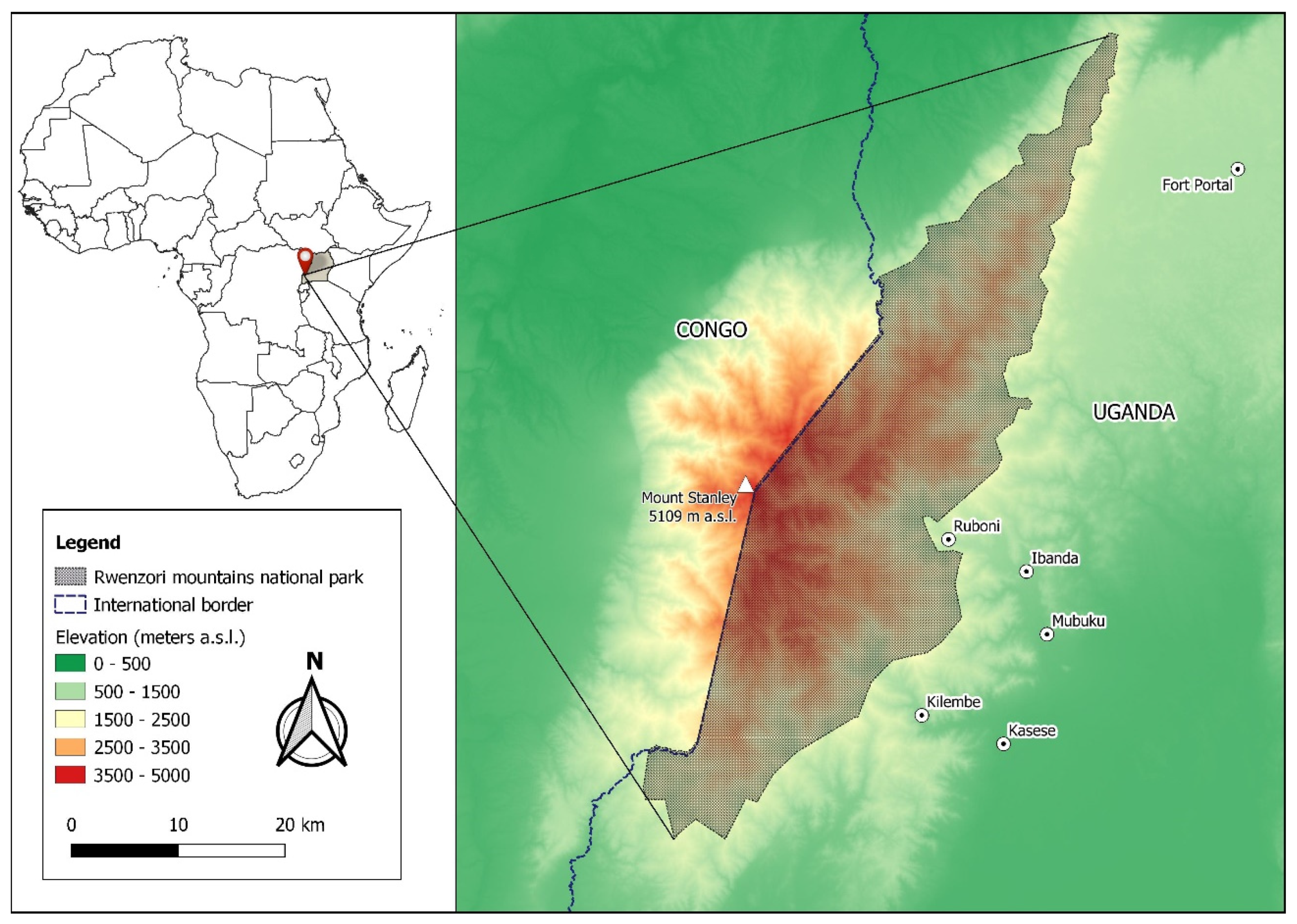
2.1. Study Area

Rwenzori Park is situated in the districts of Kasese, Kabarole and Bundibugyo. It rises from an altitude of about 1670 m to 5109 m a.s.l. with Margherita, the third highest peak in Africa, and covers an area of about 1000 km2 [34]. The Rwenzori Mountains are a biodiversity hotspot along the Albertine Rift [36]. The area has two rainy seasons from March to May and September to December [37]. Rwenzori Park was established under Uganda Wildlife Authority management in 1991 for its biodiversity values, including its unique Afro-alpine ecosystem [6,34,38].
The Mubuku valley is one of the three valleys located at the foothills of Rwenzori Park, comprising Ruboni, Bugoye, Maliba, Mihunga, Bikone and Nyakalengija (Figure 1). Based on census data from the subcounty of Bugoye and the whole country, we estimate that the Ruboni community, which covers approximately 6 km2, has a population of 1200, of whom 50% are over the age of 15 [39]. The ethnic group of the Bakonjo people dominate areas around Rwenzori Park, occupying mostly the mountainous area [40]. The locals are mainly involved in subsistence and commercial farming, growing crops such as coffee, yams, maize, rice, banana, cassava and beans [6]. They are also involved in fishing and animal rearing on a small scale.
The spatial and temporal patterns of land cover change in Rwenzori Mountains National Park and in a 10 km buffer zone show a bimodal pattern of the landscape, with fast and unidirectional changes in land cover outside the park and no change inside the park (see Appendix A).

2.2. Data Collection

This study involved the collection of primary data in January and February 2018 by questionnaire-based interviews which included open, semi-open and closed questions (Supplementary Material, SM1). The questionnaire was in the English language for self-administration outline and, for those who could not understand English, we had an interpreter who translated it into Lhukonzo, the area’s local language. The questionnaires were designed to understand the perception of the inhabitants of Ruboni towards tourism and the elements of the landscape. They included several questions regarding the demographic features, tourism influence and the perception of landscape elements, rated in two classes or a 5-point Likert scale. In the latter case, we reclassified the categories into two classes for interpretation: lower and higher than a score of 3.
The questions also included a photo survey to assess the respondents’ preferences for existing and proposed infrastructures. A second photo survey was conducted to understand the local people’s awareness of non-native plant species, Senna spectabilis and Lantana camara, growing in the area. The first is a South American tree species already spreading along the Albertine Rift, mostly in Budongo Forest Reserve [41]. The respondents were aware of the introduction of S. spectabilis during the colonial period for firewood and building poles production in an attempt to preserve the natural forests from deforestation [41]. The species is also commonly used as a boundary marker. The second non-native species is Lantana camara, which is widely spread across the country [41,42]. Lantana camara was introduced in the 1960s for hedges and the construction of stands for drying plates, and they are widely distributed all over the country, forming dense thickets [41,43].
The population of this survey is represented by the Ruboni community, the closest village to Rwenzori Park in the Mubuku valley. The interview covered 51 respondents (10% of the target population of the Ruboni community) including students, farmers, local traders, tourism workers, village administration and teachers. With this sample size, the margin of error for estimating the proportion of two classes was ±13%.
Of the 51 people interviewed, 57% were males while 43% were females, and the majority fell within the age groups of 15–25 (39%) and 26–35 (31%). This age group is considered the most productive within the population and thus gradually initiates more anthropogenic threats to the park resources and its buffer zone landscapes [44].
Most respondents (41%) had attained education with qualifications from the tertiary level and university followed by those at the secondary level (37%). The level of education implies a considerable literacy level in line with the national literacy rate [39]. Indeed, a high education level might contribute to the awareness of natural resource biodiversity and conservation values. The conservation and protection of the landscape and nature values is being emphasized among the people of the area through sensitization, education and involvement of the community in nature conservation organizations. The Ruboni Community Conservation and Development Program, involved in the empowerment of the community, is an example of such programs. Ecotourism, restaurant and bar services, craft making ventures, tree plantation and the carbon market are some of the activities promoted by the Ruboni Development Program [41].
The main source of the respondents’ livelihood was subsistence farming, where a variety of food crops such as bananas, cassavas, yams, beans, maize, potatoes and coffee are grown in the home gardens. The majority of respondents (58%) declared agriculture as their main source of livelihood. This is in line with the agroforestry practice documented by the National Census on national household livelihoods (82%) and by several research works [6,34,42].

3. Results

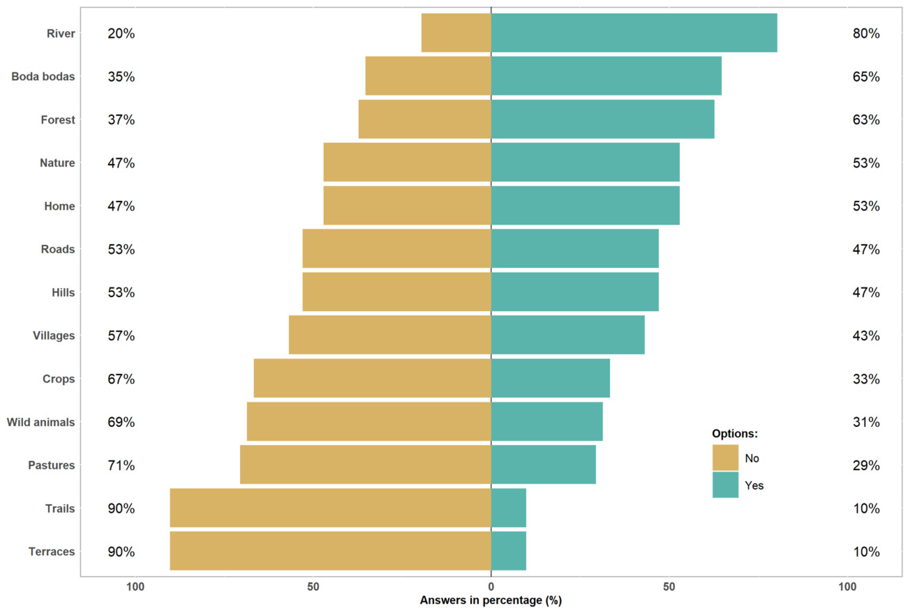
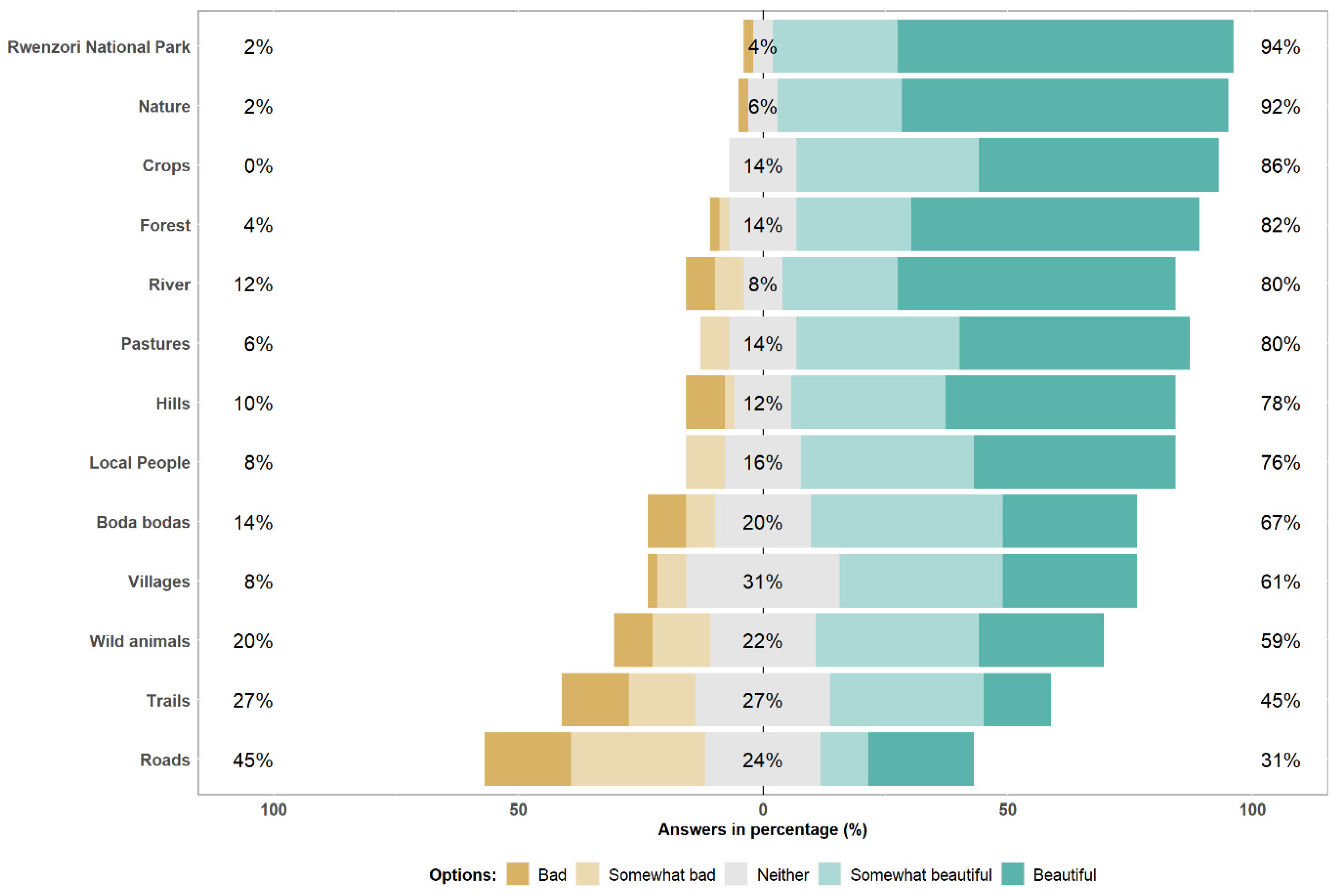
3.1. Landscape Perception

The questionnaire was aimed at understanding the inhabitants of Ruboni’s perception of the landscape and its features, tourism and invasive non-native plants knowledge (to consult questionnaire responses see Supplementary Material, SM2). The results from Figure 2 show the essential elements that best describe the place of residence as perceived by the local people. Most of the population considered the river, the forest and the local motorcycles used as taxis, boda bodas, essential. On the contrary, they did not perceive the elements of the agricultural landscape and wild animals as essential for the description of the place where they live (Figure 2). Terraces, trails, pastures, wild animals and crops were considered unessential.
Figure 3 reports the scenic beauty that landscape features have according to Ruboni inhabitants, rated on a 5-point Likert scale. Distinguishing two classes of values, those higher and lower than 3 on the Likert scale, the features which were not regarded as beautiful were roads, trails, wild animals and villages. On the contrary, Rwenzori Park, nature, crops, the forest, the river and pastures were seen as beautiful.
Rwenzori Park, nature, and the agroforestry landscape in general were the features with the highest scenic value attributed to the landscape. While the agricultural components of the landscape were not considered essential to describe the place of residence per se by most people, these features promote a certain feeling of natural environment closeness in everybody. In fact, the river, forest and nature were also valued positively for their beautiful scenery.

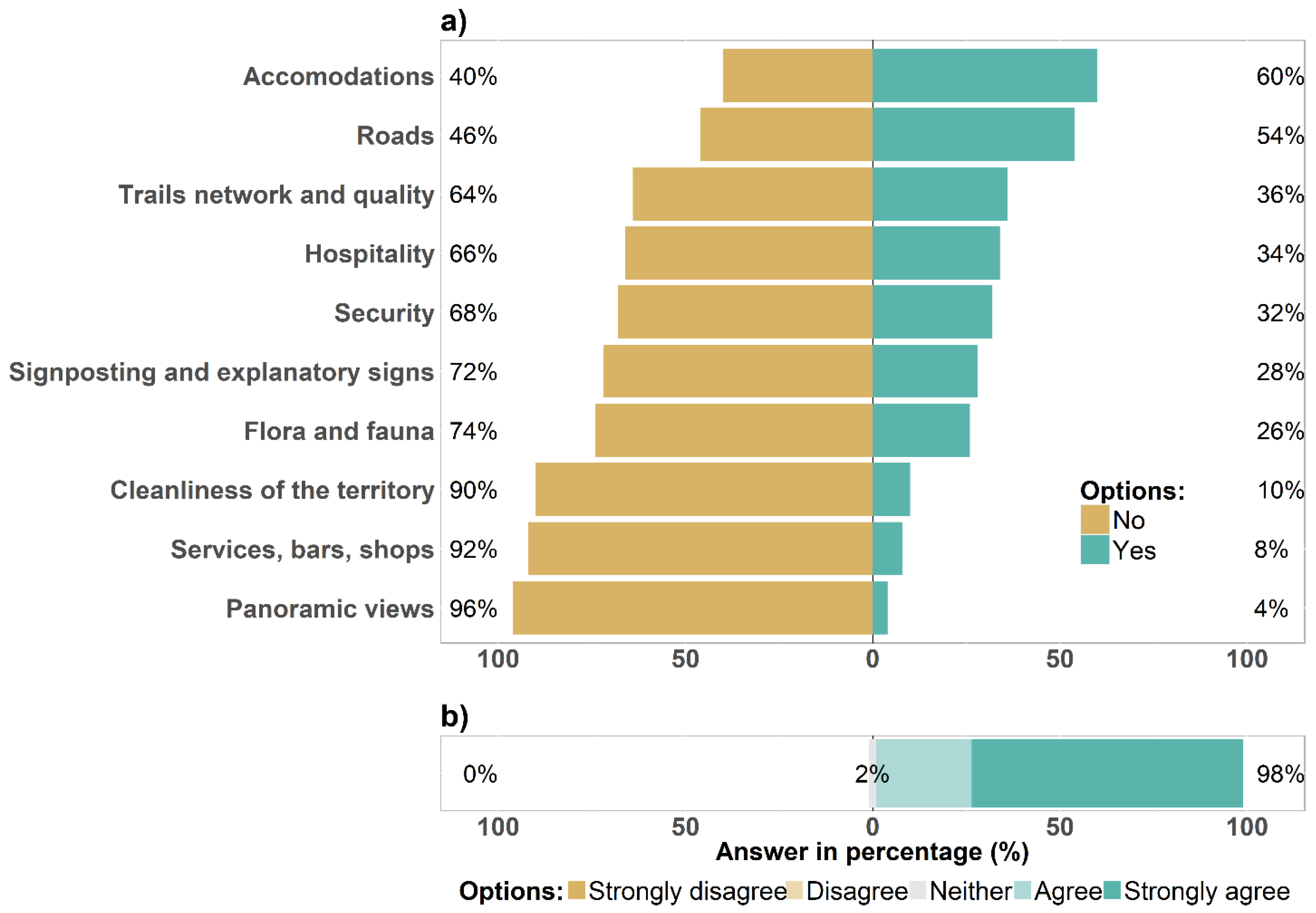
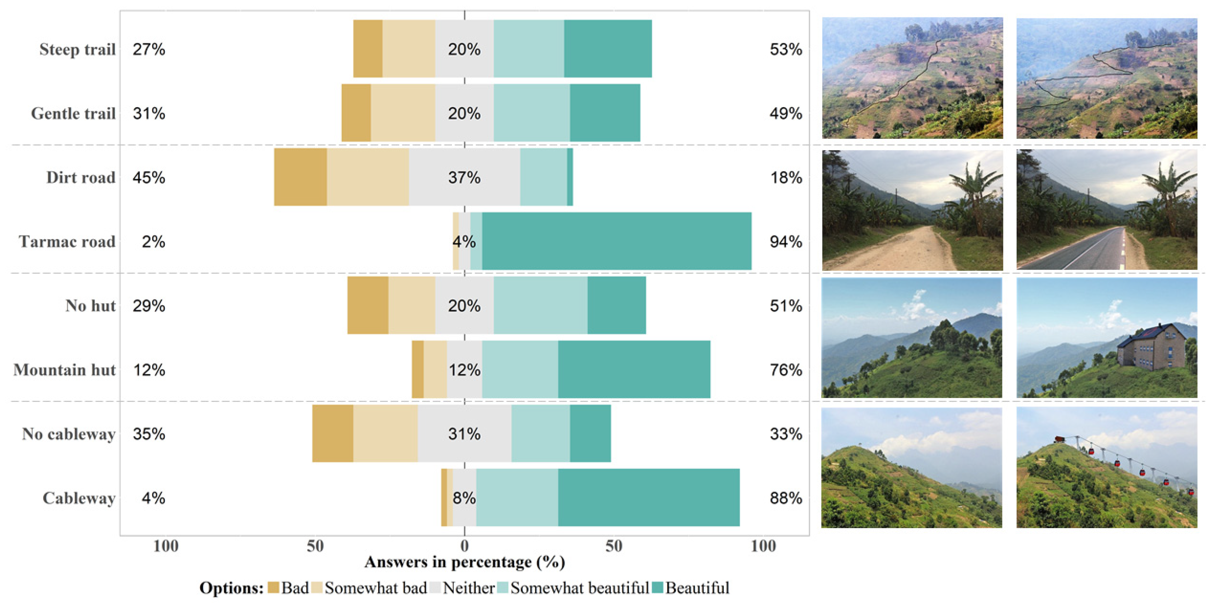
3.2. Tourism Perception

Respondents were also asked what elements needed to be improved to make the valley more attractive for tourism. The results show that the respondents considered improvements as only being necessary for accommodations and roads (Figure 4a). This is coherent with Figure 4b. Almost all the respondents (98%) considered the landscape attractive for tourism.
The photo preference surveys assessed the local people’s perception and attitude towards the landscape and compared the existing infrastructure with proposed general and tourism-related services (Figure 5).
Distinguishing two classes of values, those higher and lower than 3 on the Likert scale, the respondents preferred a tarmac road (94%), mountain hut (76%) and a cableway (88%) to a dirt road and the absence of huts and cableways. The scenario with infrastructure improvements is evidently well supported. However, the respondents did not find any difference between a steep and a gentle trail.

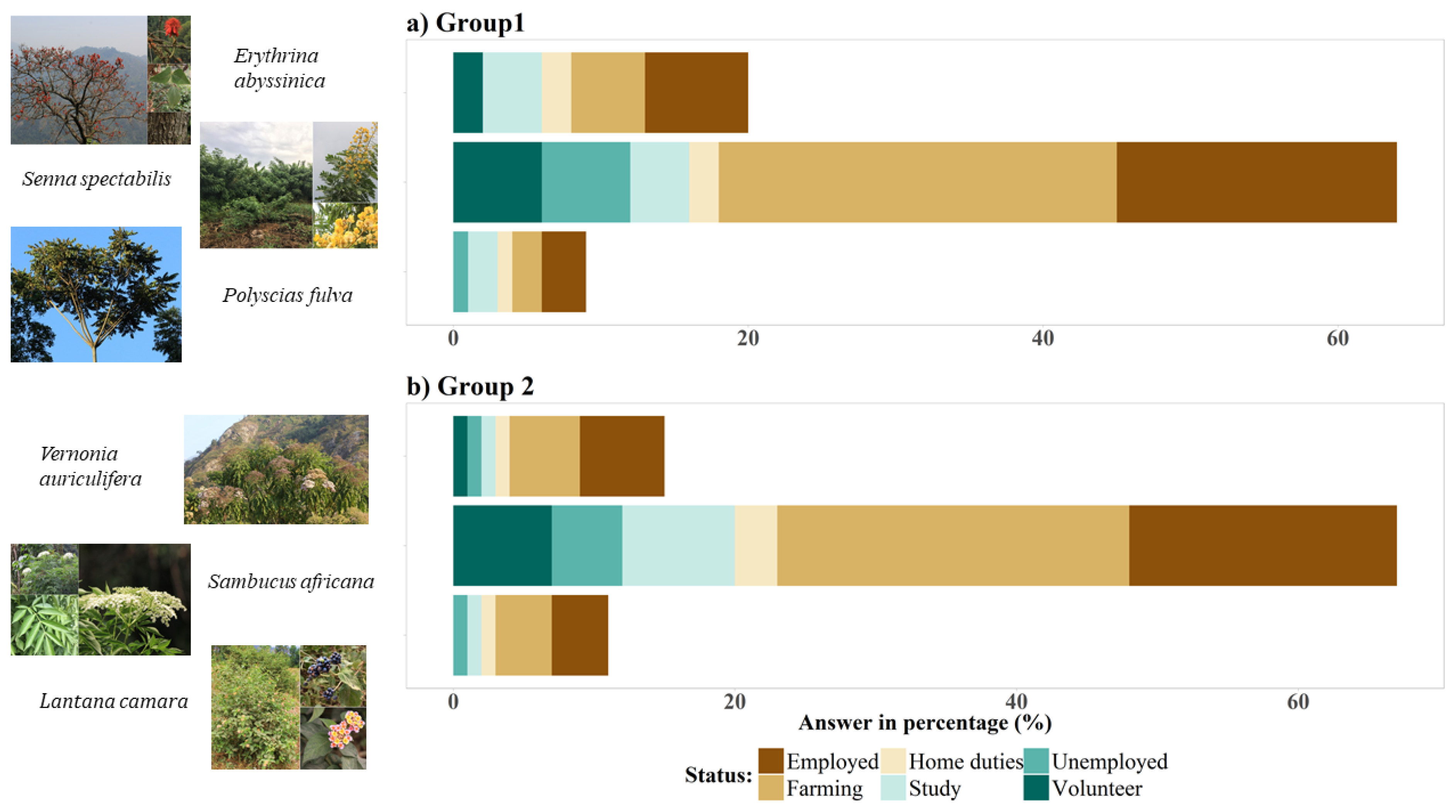
3.3. Local People’s Knowledge of Two Invasive Non-Native Plant Species

A photo survey was conducted to assess the local people’s knowledge and perception of two non-native plants, Senna spectabilis and Lantana camara. The survey was categorized into two groups (Figure 6). The two non-native plants were combined with two native plants. Senna spectabilis was recognized and identified as a non-native plant species by many respondents (69%), the majority of whom were farmers, followed by employees. The second species, Lantana camara, was not recognized as a non-native shrub, while most of the respondents from all livelihoods declared Sambucus africana as non-native to Uganda; however, Sambucus africana and Vernonia auriculifera are native to Uganda [43,45].

4. Discussion

4.1. Landscape Perception

The results of the questionnaire show a strong emotional involvement of the respondents towards almost all the landscape elements mentioned in Figure 3. Nearly all the respondents expressed the beauty and elegance of the valley in relation to nature, the park status, forest and river, in line with the findings from other study areas [42,46,47,48].
The local people derive their livelihoods from natural resources in the surrounding areas where they obtain both tangible and intangible ecosystem resources. This justifies the connection we found among the local people and natural elements of the valley where they live. The local people also positively described their landscape with crops, the main source of livelihood for most families in the valley. Indeed, this result well describes a system of extensive farming where the local people derive their livelihood mainly from crop production [6,7]. Compared with the other features being assessed, wild animals received a lower rating (Figure 3) and were perceived as non-essential (Figure 4) by the respondents. Other studies found that wild animals are considered as crop pests [10] and are aggressive to people [42]. Indeed, crop raiding by wild animals represents a considerable cost of conservation attributed to natural wildlife areas protection and management and is directly linked to nutrition and income source loss and the indirect loss of children’s education [10,42,49].
The respondents assessed most human engineered features negatively because they did not match their expectations. Boda bodas, for example, are perceived as not safe because of the number of accidents, while other elements such as roads, property, tracks and culture are not economically viable to the community [50].

4.2. Tourism Perception

We also tried to investigate the local people’s perception of tourism. According to the results from Figure 4a, the local people have a clear vision of the priority actions necessary to increase the number of tourists in the valley. Accommodations and roads are the priority features to be improved to make the valley more attractive for tourists. This is in line with the negative perception local people have about the roads as seen from Figure 3. For most respondents, “panoramic views” are not a priority for improvement to encourage tourism in the area. The landscape of the Mubuku valley is beautiful to the local people and already attractive for tourism. However, as soon as infrastructures that enhance accessibility and usability are shown, they are seen within the perspective of the economic development of the valley. As revealed by the interviews, the expression of emotional beauty of the facilities and the contribution to easier transportation influenced the respondents’ choice of tarmac roads and cableways. The positive perception for tarmac road development proposed in the area is viewed from the economic point because of the employment opportunities attached to tourism systems and the transportation of agricultural products; this result is in line with studies in other rural areas of Africa and elsewhere [49,51].
In line with our findings, several studies confirmed that rural communities view tourism as an economic development strategy [42,46,48]. However, we assume that locals are mainly concerned with the economic benefits from facility development to better their livelihoods and are unaware about possible environmental impacts. This seems clear looking at the results of Figure 5, in which respondents appreciate the overall view of the landscape, cableways and mountain huts and reveal no suspicion of a potential landscape alteration.
Therefore, it is evident that the local people did not perceive tourism development in the Mubuku valley as a possible factor of excessive transformation of the natural and cultural identity of the valley. Respondents showed no significant interest in improving small tourism facilities such as mountain trails and seemed to prefer larger structures such as cableways and masonry mountain huts. This issue has important implications for the development of the valley since, in the case of investments in the tourism sector, the local population would support the development of tourism infrastructure without being aware of the implications for the cultural and natural identity of the Mubuku valley.

4.3. Local People’ Knowledge of Two Invasive Non-Native Plant Species

Results from the photo survey of non-native plants revealed that the local community is not always aware of plants’ provenance. Awareness of the non-native origin of these species might be influenced by their ability to spread spontaneously in the environment [52]. In fact, while the distribution of S. spectabilis is dependent on the planting in the Mubuku valley, L. camara is naturally spread along the valley and in other Afromontane ecosystems [53]. This might have influenced the local people’s perception about these non-native species.
Although not confirmed by the results, some respondents ascertained that L. camara specifically causes places they invade to lose their natural identity (landscape structure, function and composition). Indeed, this invasive species is regarded as one of the most destructive species in Africa. It is known for its important impacts on ruminant livestock [54,55]. Moreover, Lantana camara seems to have indirect effects on human health since tsetse flies are attracted by this shrub while seeking refuge from high temperature [56].
Our results suggest that the local people are just partially aware of the presence of invasive species in their place of residence and, perhaps, of the detrimental nature of invasive species as a threat to their landscape’s unique character [57]. Interestingly, a partial or absent awareness of processes that can alter the identity of Rwenzori was found with respect to both tourism development and the presence of invasive species.

5. Conclusions

The Rwenzori region is exposed to negative forces of transformation because of various land use changes, especially due to agricultural activities, forestry, invasive species introduction, grazing and human settlements. The bimodal land cover change patterns (see Appendix A) of Rwenzori Park and its surroundings evidence the necessity to manage the social and environmental issues with a different strategy.
Our study confirmed the vital connection between local people and natural resources through the respondents’ perception. Therefore, in line with previous studies of Rwenzori [34], the strong dependence on the park’s natural resources should be met with an improved access to resources, which are currently only available with a permit in the “collaborative resource use zone”.
We observed no evidence of the negative perception of the park found in other studies [34]. This was not the main focus of the study and the way the question was expressed probably influenced the result.
As an important outcome, our study showed that the local people are greatly confident that an improvement in their living conditions will come from an increase of visitors in the Mubuku valley and therefore they welcome tourist facilities such as new accommodations and a cable car.
The positive attitude towards tourism is in line with other case studies [42,58] and with what was partially found in the Rwenzori [34]. However, as verified in another Ugandan national park, this enthusiasm may not last long [59]. The possible tourism development can shift the local people from agricultural land use to the tourism system. This may eventually promote landscape conservation as long as it does not lead to the total abandonment of agricultural activities, which would result in a loss of local identity.
From our perspective, the park can contribute to a better life for the local people. Hence, we suggest that better access to natural resources should be guaranteed in contrast to the segregative management that could weaken the local people and to a development of tourism that does not respect the historical and cultural identity of the place. Therefore, Rwenzori Park and its surroundings need to be sustainably planned and managed to boost the community in support of landscape conservation. Moreover, the knowledge and understanding of public opinion concerning the need for nature protection and achieving the desirable landscape quality is essential for the long-term management of a landscape’s quality.
In other words, the expected socio-economic development of Rwenzori needs to be guided, with an integrated view, to create new economic opportunities while respecting the socio-cultural identity of the place and safeguarding one of the richest areas in biodiversity in Africa. Finally, the complex, beautiful and shifting agroforestry mosaic of the Rwenzori is still one of the key factors of the area’s attractiveness, providing that a less bimodal pattern of land governance is developed.

Supplementary Materials

The following supporting information can be downloaded at: https://www.mdpi.com/article/10.3390/land11050650/s1, SM1: Questionnaire form, SM2: Database of questionnaire responses.

Author Contributions

Conceptualization, T.S. and S.I.; methodology, T.S., D.K.M. and S.I.; formal analysis, C.P., S.I., E.F. and F.C.; investigation, S.I., C.P., T.S. and J.O.; resources, S.I., T.S. and C.P.; writing—original draft preparation, C.P., J.O., T.S. and S.I.; writing—review and editing, S.I., C.P., J.O., D.K.M., E.F., F.C. and T.S.; supervision, T.S.; project administration, T.S.; funding acquisition, T.S. All authors have read and agreed to the published version of the manuscript.

Funding

This research was funded by: (1) the Department of Land, Environment, Agriculture and Forestry of the University of Padova within the project J:ROBIN “Linda Scattolin” (DALL_FINA_P14_03 and DALL_FINAC_P14_02), under the coordination of Tommaso Sitzia; (2) Erasmus+ KA107 2016-2018 Programme between University of Padova and Makerere University, coordinated by Tommaso Sitzia.

Institutional Review Board Statement

Not applicable.

Informed Consent Statement

Informed consent was obtained from all subjects involved in the study.

Data Availability Statement

The data used for the analysis of the questionnaire administered to the local people are available in the Supplementary Material SM2.

Acknowledgments

We thank all staff members of Ruboni Community Conservation and Development Program and Ruboni Community Camp; the staff and rangers of Uganda Wildlife authority; and the staff of Rwenzori Mountaineering Services. We also thank the entire community of Ruboni and the neighbouring villages for their warm welcome and cooperation. We also thank Elly Bwabu, who guided us and acted as an interpreter with his sympathy and experience.

Conflicts of Interest

The authors declare no conflict of interest. The funders had no role in the design of the study; in the collection, analyses, or interpretation of data; in the writing of the manuscript; or in the decision to publish the results.

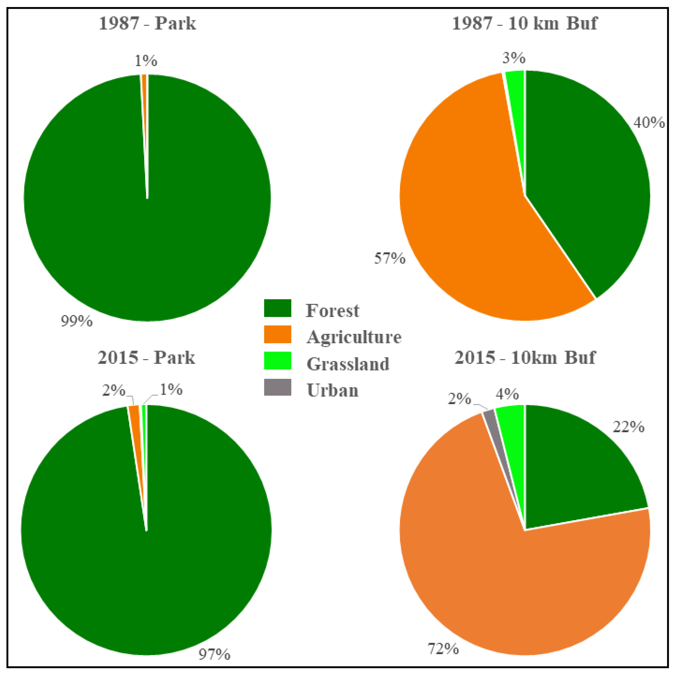
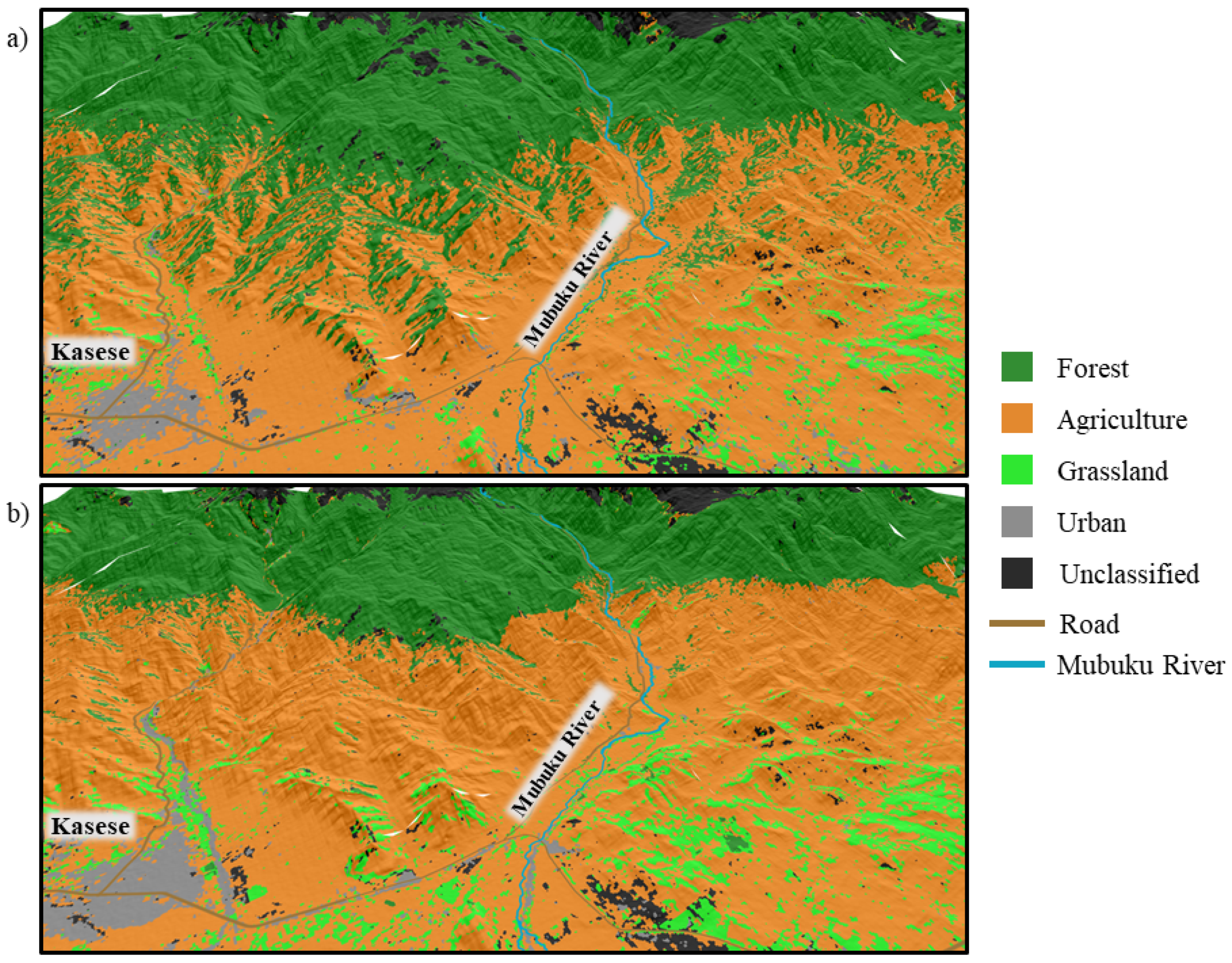
Appendix A. Land Cover Change Analysis

Appendix A.1. Material and Methods

Landsat data is often used in research to evaluate land cover and monitor the change in different years [60,61,62,63,64,65]. During satellite image dataset pre-processing, a set of Landsat images with 30 × 30 m spatial resolution was used to analyse land cover change in Rwenzori. The images were acquired at a product level 1T (radiometrically and geometrically terrain corrected) from the GLOVIS web portal [66]. We selected the most cloud-free images with a cloud cover of less than 10%. Each band of each Landsat image was processed by converting reflective band data into at-sensor reflectance using QGIS 2.18.2 and the semi-automatic classification plug-in separately.
Snow and cloud were masked using the normalized difference snow index and an empirically set threshold value on Band 1 following image inspection and interpretation. The images were then cut to cover the Rwenzori Park borders and a 10 km buffer area. The size of the buffer area was hypothesized as being right to capture the socio-economic effects of the park, as applied in other studies [67].
We used Google Earth to identify and select homogeneous patches of different land cover classes (forest, agriculture, grassland and human settlement) for the image classification training dataset. The normalized difference vegetation index was used as an additional band to increase classification accuracy. Pre-processed and stacked images were then classified using non-parametric classification algorithms (support vector machines, SVM) and the Google Earth-derived training dataset for the four identified land cover classes. Land cover changes were then identified for Rwenzori Park and the 10 km buffer area, by comparing 1987 vs. 2015 land covers.

Appendix A.2. Results and Discussion

Land cover classifications from 1987 to 2015 showed an extreme contrast between the park and a 10 km buffer zone. In fact, the areas of the park below the timberline were nearly totally forested in 1987 and showed 97% forest cover by 2015. Some small isolated patches of grasslands are dispersed through the forest matrix and there are agricultural lands near the park’s borders. The buffer zone is a mosaic of all classes of land cover dominated by agricultural activities covering 57% of the area in 1987, which increased to 72% in 2015, followed by forest cover occupying 40% of the area in 1987 and 22% in 2015. Human settlements were absent in 1987, while by 2015 they covered 2% of the area (Figure A1).
Figure A1. The trend of land cover change in Rwenzori Park and a 10 km buffer zone using Landsat images from 1987 and 2015.
Land 11 00650 g0a1
The number and size of the patches of each land cover category followed the expected patterns of predominantly forested landscape versus fragmented forests in an agricultural matrix. The 10 km buffer zone contains many small forest patches while large patches of forest occur in the park in line with other areas close to nature reserves of Uganda [68].
Therefore, based on a visual examination of the Landsat images and assessing the diminishing resource bases at the landscape scale (Figure A2), the park is characterized by a biodiversity rich, minimally changing land cover [10,69]. The change in forest cover has been attributed to the illegal harvesting of forest timber and non-timber forest products in and at the borders of the national park [7]. Therefore, the park landscape is a sort of forested land matrix surrounded by an agricultural landscape interspersed with a network of grassland, patches of forest plantations, urbanized areas and wetlands. These land cover changes affect the management of human ecological systems, which eventually alters the biogeochemical cycles, hydrology and climate of the ecosystem. One of the most recent impacts is due to invasions of non-native plants, such as Senna spectabilis and Lantana camara [11,70,71].
Figure A2. Spatial and temporal patterns of land cover change in Rwenzori Park and a 10 km buffer zone: Landsat images of 1987 (a) and 2015 (b).
Land 11 00650 g0a2
Small–scale agricultural expansion by local people explains the majority of forest loss in the fragmented, unprotected landscape of the Mubuku valley and, although there are no direct effects on the park, it could be affected in terms of a less permeable landscape matrix [6,7,9,72]. The human population pressures explain the high rate of deforestation and degradation both in the 10 km buffer areas and around the park boundaries. This is known to affect biodiversity components of the landscape by changing ecosystem types and land forms across large geographic areas. Changes in habitat mosaics alter the patterns of species distribution and functions of the landscape such as watershed protection and carbon sequestration [7,9,16]. While this is one of the potential explanations for agricultural landscape expansion into forested zones of Rwenzori Park and the 10 km buffer zone, the contribution of the expanding human populations and the underlying drivers remain largely speculative. Therefore, as stated by Antrop [32], intensive land use is closely related to spatial fragmentation and the homogenization of landscape elements resulting in the loss of place identity. However, the role of livelihood conditions, including education levels, rural incomes, cropping patterns and land tenure systems, together with biophysical conditions, including soil quality, aspect and slope, may all provide an explanation for the observed trends in Rwenzori land cover change.

References

  1. Mill, R.C.; Morrison, A.M. The Tourism System, 1st ed.; Prentice-Hall: Englewood Cliffs, NJ, USA, 1985. [Google Scholar]
  2. Gkoltsiou, A.; Terkenli, T.S. An interdisciplinary analysis of tourist landscape structure. Tour. Int. Multidiscip. J. Tour. 2012, 7, 145–164. [Google Scholar]
  3. Pearce, D.G. Tourism Today: A Geographical Analysis, 2nd ed.; Longman Scientific & Technical: Canterbury, UK, 1995. [Google Scholar]
  4. Jafari, J. The components and nature of tourism: The tourism market basket of goods and services. Ann. Tour. Res. 1974, 1, 73–89. [Google Scholar] [CrossRef]
  5. Briassoulis, H. Sustainable tourism and the question of the commons. Ann. Tour. Res. 2002, 29, 1065–1085. [Google Scholar] [CrossRef]
  6. Tumusiime, D.M. Dependence on Environmental Income by Households around Rwenzori Mountain National Park, Western Uganda; Norwegian University of Life Science: Noragric, Norway, 2006. [Google Scholar]
  7. Tumusiime, D.M.; Vedeld, P.; Gombya-Ssembajjwe, W. Breaking the law? Illegal livelihoods from a Protected Area in Uganda. For. Policy Econ. 2011, 13, 273–283. [Google Scholar] [CrossRef]
  8. Wunder, S.; Angelsen, A.; Belcher, B. Forests, livelihoods, and conservation: Broadening the empirical base. World Dev. 2014, 64, S1–S11. [Google Scholar] [CrossRef] [Green Version]
  9. DeFries, R.; Hansen, A.; Turner, B.L.; Reid, R.; Liu, J. Land use change around protected areas: Management to balance human needs and ecological function. Ecol. Appl. 2007, 17, 1031–1038. [Google Scholar] [CrossRef] [PubMed]
  10. Gadd, M.E. Conservation outside of parks: Attitudes of local people in Laikipia, Kenya. Environ. Conserv. 2005, 32, 50–63. [Google Scholar] [CrossRef] [Green Version]
  11. Garrard, R.; Kohler, T.; Price, M.F.; Byers, A.C.; Sherpa, A.R.; Maharjan, G.R. Land use and land cover change in Sagarmatha National Park, a world heritage site in the Himalayas of Eastern Nepal. Mt. Res. Dev. 2016, 36, 299–310. [Google Scholar] [CrossRef]
  12. Howard, P.C.; Davenport, T.R.B.; Kigenyi, F.W.; Viskanic, P.; Baltzer, M.C.; Dickinson, C.J.; Lwanga, J.; Matthews, R.A.; Mupada, E. Protected area planning in the tropics: Uganda’s national system of forest nature reserves. Conversat. Biol. 2000, 14, 858–875. [Google Scholar] [CrossRef] [Green Version]
  13. Matson, P.A.; Parton, W.J.; Power, A.G.; Swift, M.J. Agricultural intensification and ecosystem properties. Science 1997, 277, 504–509. [Google Scholar] [CrossRef] [Green Version]
  14. Mwavu, E.N.; Witkowski, E.T.F. Land-Use and Cover Changes (1988–2002) around Budongo Forest Reserve, NW Uganda: Implications for Forest and Woodland Sustainability. Land Degrad. Dev. 2008, 19, 606–622. [Google Scholar] [CrossRef]
  15. Turner, I.M.; Corlett, R.T. The conservation value of small, isolated fragments of lowland tropical rain forest. Trends Ecol. Evol. 1996, 11, 330–333. [Google Scholar] [PubMed]
  16. Putz, F.E.; Blate, G.M.; Redford, K.H.; Fimbel, R.; Robinson, J. Tropical forest management and conservation of biodiversity: An overview. Conserv. Biol. 2001, 15, 7–20. [Google Scholar] [CrossRef] [Green Version]
  17. Hansen, A.J.; DeFries, R. Ecological mechanisms linking protected areas to surrounding lands. Ecol. Appl. 2007, 17, 974–988. [Google Scholar] [CrossRef] [PubMed]
  18. Bollmann, K.; Braunisch, V. To integrate or to segregate: Balancing commodity production and biodiversity conservation in European forests. In Integrative Approaches as an Opportunity for the Conservation of Forest Biodiversity; Kraus, D., Krumm, F., Eds.; European Forest Institute: Freiburg, Germany, 2013. [Google Scholar]
  19. Castella, J.-C.; Lestrelin, G.; Hett, C.; Bourgoin, J.; Fitriana, Y.R.; Heinimann, A.; Pfund, J.-L. Effects of landscape segregation on livelihood vulnerability: Moving from extensive shifting cultivation to rotational agriculture and natural forests in northern Laos. Hum. Ecol. 2013, 41, 63–76. [Google Scholar] [CrossRef]
  20. Bulafu, C.E.; Tumusiime, D.M.; Erik Hårklau, S.; Owuor, G. Status of illegal resource extraction within Rwenzori Mountains National Park, Uganda: Baseline studies near four hydropower projects. Afr. J. Ecol. 2021, 59, 449–465. [Google Scholar] [CrossRef]
  21. Buhanga, E.; Namuli, S.; Kapere, R.; Kayanja, K.F.; Mbogha, F.; Edson, T.; Gangiriba, R.; Enyagu, N.; Guma, N.; Kooli, A.; et al. Rwenzori Mountains National Park General Management Plan 2016–2025; Uganda Wildlife Authority: Kampala, Uganda, 2016. [Google Scholar]
  22. Didham, R.K.; Tylianakis, J.M.; Hutchison, M.A.; Ewers, R.M.; Gemmell, N.J. Are invasive species the drivers of ecological change? Trends Ecol. Evol. 2005, 20, 470–474. [Google Scholar] [CrossRef]
  23. García-Llorente, M.; Martín-López, B.; González, J.A.; Alcorlo, P.; Montes, C. Social perceptions of the impacts and benefits of invasive alien species: Implications for management. Biol. Conserv. 2008, 141, 2969–2983. [Google Scholar] [CrossRef] [Green Version]
  24. Vitousek, P.M.; D’Antonio, C.M.; Loope, L.L.; Rejmánek, M.; Westbrooks, R. Introduced species: A significant component of human-caused global change. N. Z. J. Ecol. 1997, 21, 1–16. [Google Scholar]
  25. Kendle, A.D.; Rose, J.E. The aliens have landed! What are the justifications for ‘native only’ policies in landscape plantings? Landsc. Urban Plan. 2000, 47, 19–31. [Google Scholar] [CrossRef]
  26. Scalera, R.; Genovesi, P.; Essl, F.; Rabitsch, W. The Impacts of Invasive Alien Species in Europe. Technical Report No 16/2012; European Environment Agency: Luxembourg, 2012; p. 114. [Google Scholar]
  27. Cordeiro, B.; Marchante, H.; Castro, P.; Marchante, E. Does public awareness about invasive plants pays off? An analysis of knowledge and perceptions of environmentally aware citizens in Portugal. Biol. Invasions 2020, 22, 2267–2281. [Google Scholar] [CrossRef]
  28. Cohen, E. The impact of tourism on the physical environment. Ann. Tour. Res. 1978, 5, 215–237. [Google Scholar] [CrossRef]
  29. Forman, R.T.T.; Alexander, L.E. Roads and their major ecological effects. Annu. Rev. Ecol. Syst. 1998, 29, 207–231. [Google Scholar] [CrossRef] [Green Version]
  30. Butler, R. Tourism Landscapes: For the Tourist or of the Tourist? Tour. Recreat. Res. 1992, 17, 3–9. [Google Scholar] [CrossRef]
  31. Barker, M.L. Traditional landscape and mass tourism in the Alps. Geogr. Rev. 1982, 72, 395–415. [Google Scholar] [CrossRef]
  32. Antrop, M. Landscape change: Plan or chaos? Landsc. Urban Plan. 1998, 41, 155–161. [Google Scholar] [CrossRef]
  33. Petrova, S.; Čihař, M.; Bouzarovski, S. Local nuances in the perception of nature protection and place attachment: A tale of two parks. Area 2009, 43, 327–335. [Google Scholar] [CrossRef]
  34. Galabuzi, C.; Tumwesigye, A. Current Knowledge, Attitudes and Practices of Local Communities Surrounding Rwenzori Mountains National Park; Faculty of Forestry and Nature Conservation, Makerere University: Kampala, Uganda, 2009. [Google Scholar]
  35. Bwambale, B.; Muhumuza, M.; Nyeko, M. Traditional ecological knowledge and flood risk management: A preliminary case study of the Rwenzori. JÀMbÁ J. Disaster Risk Stud. 2018, 10, a536. [Google Scholar] [CrossRef]
  36. Howard, P.C.; Butler, J.; Howard, P. Nature Conservation in Uganda’s Tropical Forest Reserves, 1st ed.; IUCN: Gland, Switzerland, 1991. [Google Scholar]
  37. Russell, J.; Eggermont, H.; Taylor, R.; Vershuren, D. Paleolimnological records of recent glacier recession in the Rwenzori Mountains, Uganda-D.R. Congo. J. Paleolimnol. 2009, 41, 253–271. [Google Scholar] [CrossRef]
  38. Osmaston, H. Guide to the Rwenzori: Mountains of the Moon, 2nd ed.; Titus Wilson: Kendal, UK, 2006; p. 288. [Google Scholar]
  39. Uganda Bureau of Statistics. The National Population and Housing Census 2014—Main Report; Uganda Bureau of Statistics: Kampala, Uganda, 2016; p. 108.
  40. Pennacini, C.; Wittenberg, H. Rwenzori: Histories and Cultures of an African Mountain; Fountain Publishers: Kampala, Uganda, 2007. [Google Scholar]
  41. EANST. Provision of Services for Conducting a Baseline Study and Mapping of Private Community Tourism Partnerships and Ecosystem Services Enterprises; East African Network for Sustainable Tourism: Kampala, Uganda, 2014; p. 139. [Google Scholar]
  42. Lepp, A. Residents’ attitudes towards tourism in Bigodi village, Uganda. Tour. Manag. 2007, 28, 876–885. [Google Scholar] [CrossRef]
  43. Kindt, R.; van Breugel, P.; Lillesø, J.P.B.; Minani, V.; Ruffo, C.K.; Gapusi, J.; Jamnadass, R.; Graudal, L. Potential Natural Vegetation of Eastern Africa: Volume 9. Atlas and Tree Species Composition for Rwanda; 8779036198; Department of Geosciences and Natural Resource Management, University of Copenhagen: Copenhagen, Denmark, 2014. [Google Scholar]
  44. Akosim, C.; Bode, A.S.; Kwaga, B.T.; Dishan, E.E. Perceptions and involvement of neighbouring communities of Kainji Lake National Park towards the Parks conservation programmes. J. Res. For. Wildl. Environ. 2010, 2, 44–59. [Google Scholar]
  45. Hamilton, A.C. A Field Guide to Uganda Forest Trees; Makerere University Printery: Kampala, Uganda, 1981. [Google Scholar]
  46. Andereck, K.L.; Vogt, C.A. The relationship between residents’ attitudes toward tourism and tourism development options. J. Travel Res. 2000, 39, 27–36. [Google Scholar] [CrossRef]
  47. Hartter, J.N. Attitudes of rural communities towards wetlands and forest fragments around Kibale National Park, Uganda. Hum. Dimens. Wildl. 2009, 14, 433–447. [Google Scholar]
  48. Zamani-Farahani, H.; Musa, G. Residents’ attitudes and perception towards tourism development: A case study of Masooleh, Iran. Tour. Manag. 2008, 29, 1233–1236. [Google Scholar] [CrossRef]
  49. Lepp, A. Tourism in a Rural Ugandan Village: Impacts, Local Meaning, and Implications for Development; University of Florida: Gainesville, FL, USA, 2004. [Google Scholar]
  50. Bwabu, E.; Rwenzori Mountaineering Services, Nyakalengija, Uganda. Personal communication, 2018.
  51. Sowińska-Świerkosz, B.; Chmielewski, T.J. Comparative assessment of public opinion on the landscape quality of two biosphere reserves in Europe. Environ. Manag. 2014, 54, 531–556. [Google Scholar]
  52. Selge, S.; Fischer, A.; van der Wal, R. Public and professional views on invasive non-native species–A qualitative social scientific investigation. Biol. Conserv. 2011, 144, 3089–3097. [Google Scholar] [CrossRef]
  53. Canavan, K.; Canavan, S.; Clark, V.R.; Gwate, O.; Richardson, D.M.; Sutton, G.F.; Martin, G.D. The alien plants that threaten South Africa’s mountain ecosystems. Land 2021, 10, 1393. [Google Scholar] [CrossRef]
  54. Ntalo, M.; Ravhuhali, K.E.; Moyo, B.; Hawu, O.; Msiza, N.H. Lantana camara: Poisonous Species and a Potential Browse Species for Goats in Southern Africa—A Review. Sustainability 2022, 14, 751. [Google Scholar]
  55. Shackleton, R.T.; Witt, A.B.; Aool, W.; Pratt, C.F. Distribution of the invasive alien weed, Lantana camara, and its ecological and livelihood impacts in eastern Africa. Afr. J. Range Forage Sci. 2017, 34, 1–11. [Google Scholar] [CrossRef]
  56. Syed, Z.; Guerin, P. Tsetse flies are attracted to the invasive plant Lantana camara. J. Insect Physiol. 2004, 50, 43–50. [Google Scholar] [CrossRef] [PubMed] [Green Version]
  57. Sala, O.E.; Chapin, F.S.; Armesto, J.J.; Berlow, E.; Bloomfield, J.; Dirzo, R.; Huber-Sanwald, E.; Huenneke, L.F.; Jackson, R.B.; Kinzig, A.; et al. Global biodiversity scenarios for the Year 2100. Science 2000, 287, 1770–1774. [Google Scholar] [CrossRef] [PubMed]
  58. Teye, V.; Sirakaya, E.; Sonmez, S.F. Residents’ attitudes toward tourism development. Ann. Tour. Res. 2002, 29, 668–688. [Google Scholar] [CrossRef]
  59. MacKenzie, C.A.; Salerno, J.; Hartter, J.; Chapman, C.A.; Reyna, R.; Tumusiime, D.M.; Drake, M. Changing perceptions of protected area benefits and problems around Kibale National Park, Uganda. J. Environ. Manag. 2017, 200, 217–228. [Google Scholar] [CrossRef] [PubMed]
  60. Byrne, G.F.; Crapper, P.F.; Mayo, K.K. Monitoring land-cover change by principal component analysis of multitemporal Landsat data. Remote Sens. Environ. 1980, 10, 175–184. [Google Scholar] [CrossRef]
  61. Dewan, A.M.; Yamaguchi, Y. Land use and land cover change in Greater Dhaka, Bangladesh: Using remote sensing to promote sustainable urbanization. Appl. Geogr. 2009, 29, 390–401. [Google Scholar] [CrossRef]
  62. Hansen, M.C.; Loveland, T.R. A review of large area monitoring of land cover change using Landsat data. Remote Sens. Environ. 2012, 122, 66–74. [Google Scholar] [CrossRef]
  63. Majaliwa, J.G.M.; Twongyirwe, R.; Nyenje, R.; Oluka, M.; Ongom, B.; Sirike, J.; Mfitumukiza, D.; Azanga, E.; Natumanya, R.; Mwerera, R.; et al. The effect of land cover change on soil properties around Kibale National Park in south western Uganda. Appl. Environ. Soil Sci. 2010, 2010, 7. [Google Scholar] [CrossRef] [Green Version]
  64. Owor, M.; Muwanga, A.; Pohl, W. Wetland change detection and inundation north of lake George, western Uganda using Landsat data. Afr. J. Sci. Technol. 2007, 8, 94–106. [Google Scholar]
  65. Yuan, F.; Sawaya, K.E.; Loeffelholz, B.C.; Bauer, M.E. Land cover classification and change analysis of the Twin Cities (Minnesota) Metropolitan Area by multitemporal Landsat remote sensing. Remote Sens. Environ. 2005, 98, 317–328. [Google Scholar] [CrossRef]
  66. USGS. Science for a Changing World. Available online: https://glovis.usgs.gov/ (accessed on 10 January 2018).
  67. Lepers, E.; Lambin, E.F.; Janetos, A.C.; DeFries, R.; Achard, F.; Ramankutty, N.; Scholes, R.J. A synthesis of information on rapid land-cover change for the period 1981–2000. BioScience 2005, 55, 115–124. [Google Scholar] [CrossRef]
  68. Southworth, J.; Hartter, J.; Binford, M.W.; Goldman, A.; Chapman, C.A.; Chapman, L.J.; Omeja, P.; Binford, E. Parks, people and pixels: Evaluating landscape effects of an East African national park on its surroundings. Trop. Conserv. Sci. 2010, 3, 122–142. [Google Scholar] [CrossRef]
  69. Figueroa, F.; Sánchez-Cordero, V. Effectiveness of natural protected areas to prevent land use and land cover change in Mexico. Biodivers. Conserv. 2008, 17, 3223–3240. [Google Scholar] [CrossRef]
  70. Hartter, J.N.; Ryan, S.J.; Southworth, J.; Chapman, C.A. Landscapes as continuous entities: Forest disturbance and recovery in the Albertine Rift landscape. Landsc. Ecol. 2011, 26, 877–890. [Google Scholar] [CrossRef]
  71. Loveland, T.R.; Sohl, T.; Sayler, K.; Gallant, A.; Dwyer, J.; Vogelmann, J.; Zylstra, G.; Wade, T.G.; Edmonds, C.M. Land Cover Trends: Rates, Causes, and Consequences of Late-Twentieth Century U.S. Land Cover Change; United States Environmental Protection Agency, Office of Research and Development: Washington, DC, USA, 1999.
  72. Twongyirwe, R. Forests under Threat? Changes in Land Use and Forest Cover in Rural Western Uganda; University of Cambridge: Cambridge, UK, 2015. [Google Scholar]
Figure 1. Map of Uganda showing the study area and its surrounding area.
Land 11 00650 g001
Figure 2. Elements and features of the Mubuku valley considered essential by inhabitants of Ruboni to describe their place of residence.
Land 11 00650 g002
Figure 3. Scenic beauty of biological, physical and human engineered facilities and devices of the Mubuku valley and Rwenzori Park, as assessed by Ruboni inhabitants.
Land 11 00650 g003
Figure 4. Features to be improved to make the valley attractive to visitors (a) and respondents’ perception towards the tourism industry, answering the question: “Is the landscape of Mubuku valley attractive for tourism?” (b).
Land 11 00650 g004
Figure 5. Comparison of engineered facilities favouring tourism using photo surveys: assessment of respondents’ preferences.
Land 11 00650 g005
Figure 6. Results of photo survey to assess local people’s knowledge on the non-native plants, Senna spectabilis (a) and Lantana camara (b). Plot shows answers to the following question: “Which of the following species in Group 1 and 2 is not native to Uganda?”.
Land 11 00650 g006
Publisher’s Note: MDPI stays neutral with regard to jurisdictional claims in published maps and institutional affiliations.

