Article

Traditional Thoughts and Modern Development of the Historical Urban Landscape in China: Lessons Learned from the Example of Pingyao Historical City

1
College of Architecture, Xi’an University of Architecture and Technology, Yanta Road 13, Xi’an 710055, China
2
College of Architecture and Urban Planning, Tongji University, Siping Road 1239, Shanghai 200092, China
3
Chinese Academy of Surveying and Mapping, Lianhuachi West Road 28, Beijing 100830, China
4
Shaanxi Institute of Urban & Rural Planning and Design, Xintai South Street 1418, Xi’an 710021, China
5
China Northwest Architecture Design and Research Institute Co., Ltd., WenJing Road 98, Xi’an 710018, China
*
Author to whom correspondence should be addressed.
Land 2022, 11(2), 247; https://doi.org/10.3390/land11020247
Submission received: 28 December 2021 / Revised: 27 January 2022 / Accepted: 3 February 2022 / Published: 7 February 2022
(This article belongs to the Special Issue Cities' Spatial Structure and Drivers of its Transformation)

Abstract

:
In the past 40 years, China has undergone a rapid urbanization process which has led to a significant contradiction between the desire to develop modern urban spaces and the need to protect historic urban sites. Urban construction has brought not only the destruction of the physical space of the historic urban sites, but also the fragmentation of the natural landscape and its structural disconnection to the historic urban landscape. Ancient Chinese planners had their own thoughts regarding urban construction and the specific patterns of the urban landscape. The urban landscape of Chinese historic cities focuses predominantly on the structural relationship to its neighborhood. This paper aims to explore the value and character of the historic landscape of the ancient city, finding the key causes of its decline in the process of urbanization. The World Cultural Heritage city Pingyao is taken as a case study. Firstly, an analysis of its historical spatial structure and urban planning ideas of the ancient city of Pingyao using ancient maps and historical documents is presented. Then, a quantitative analysis of the urban space expansion in Pingyao city from 1989 to 2016 is conducted and its land use structure further analyzed. Additionally, four editions of the urban master plan in Pingyao have comprehensively shown that modern urban construction and planning tend to focus more on urban economic functions and social needs. In contrast, ancient urban planning relied on the spatial connection between urban space and its natural environment to construct a higher urban cultural connotation. As a result, the different development mode between modern urbanization and construction of ancient cities could be the key reason for the decline of spatial structure and landscape fragmentation of historical cities in China. With respect to the experience and thoughts of Pingyao’s ancient urban planning and construction, technical ideas and suggestions are put forward as reference in future spatial planning for Pingyao’s urban development and cultural protection. Our findings have been incorporated into the relevant sections of the spatial planning of Pingyao.

1. Introduction

The concept of “Historic Urban Landscape (HUL)” was first introduced in the Vienna Memorandum adopted by the international conference “World Heritage and Contemporary Architecture—Managing the Historic Urban Landscape” in 2005 [1]. On 10 November 2011, UNESCO’s General Conference adopted the “Recommendation on the Historic Urban Landscape”, which emphasizes the importance of the historic structure formed by the profound influence and interweaving of natural and cultural elements of a wide range of social, economic, and historical backgrounds [2]. The historical environment of a city was formed over a long period of dynamic integration between human civilization and nature. The formation of HUL is the result of a continuous dynamic process of production, interaction, and accumulation [3]. Therefore, it is very important to view the urban historical and cultural landscape from the perspective of spatial integration [4,5]. Since China’s reform and opening up, great changes in the economy have created one of the most dynamic and rapidly-expanding urban systems in the world [6]. On one hand, the rapid urbanization has brought tremendous contributions to the growth of China’s social and economic wealth during the last 40 years [7], but on the other, the impact of the explosive growth of urban spaces on traditional life presents many challenges to HUL protection [8,9,10]. In this case, a dynamic and holistic thought process should be adopted [6,11]. In December 2015, the “Central Conference of City Development” was held in Beijing, indicating the overall adjustment and reform of China’s urbanization strategy. However, the negative impact of urban sprawl has spread into all levels of China’s urban and rural spaces.
Urban sprawl, which is considered to be a spatial form of urban expansion or growth, is usually manifested in the disorderly expansion of the urban area from the central downtown to the outer suburbs [12,13,14,15]. The sprawl process can be found either in metropolitan areas or small and medium-sized cities [16,17], where the HUL often conflicts with the newly increased urban space. Against this context, a large number of historical cities in China have been at risk of being destroyed in the process of urbanization [18,19,20]. Such an effect is not only limited to the destruction of urban heritage, but also the disorder of traditional urban spatial structures and the cultural landscape [21,22,23]. Furthermore, it may well lead to the division of the physical space from the human spirit of the historical city. This situation is not uncommon, even in some of the well-known historical cities that have received widespread attentions. Regrettably, unlike the protection of historical heritage sites, such urban structures and cultural landscape related to the historical spatial elements are often the most likely to be overlooked [24,25].
In this paper, the ancient city Pingyao is chosen as a case study. It is the most well-preserved city in the Han ethnic settlements area of China and has been listed as a World Cultural Heritage Site by UNESCO since 1997 [26]. The contradiction and conflict between HUL protection and the development of the modern urban space are most prominent and representative in the city [27]. This can be reflected in the development process of modern urban spaces in Pingyao. Through a systematic review and analysis of traditional thoughts, construction methods, and various urban plans of Pingyao, we explore the impact of urban expansion on the traditional urban structure and cultural landscape, and endeavor to reveal the deep-seated problems caused by the decline of the historical and cultural environment of Pingyao from the perspective of the historic urban landscape integrity. Our aim is to demonstrate the value and character of the historic landscape of the ancient city and give concrete suggestions that could be integrated into spatial planning for future urban development. Additionally, the outcomes of the research may also be useful for other ancient cities, especially in China.

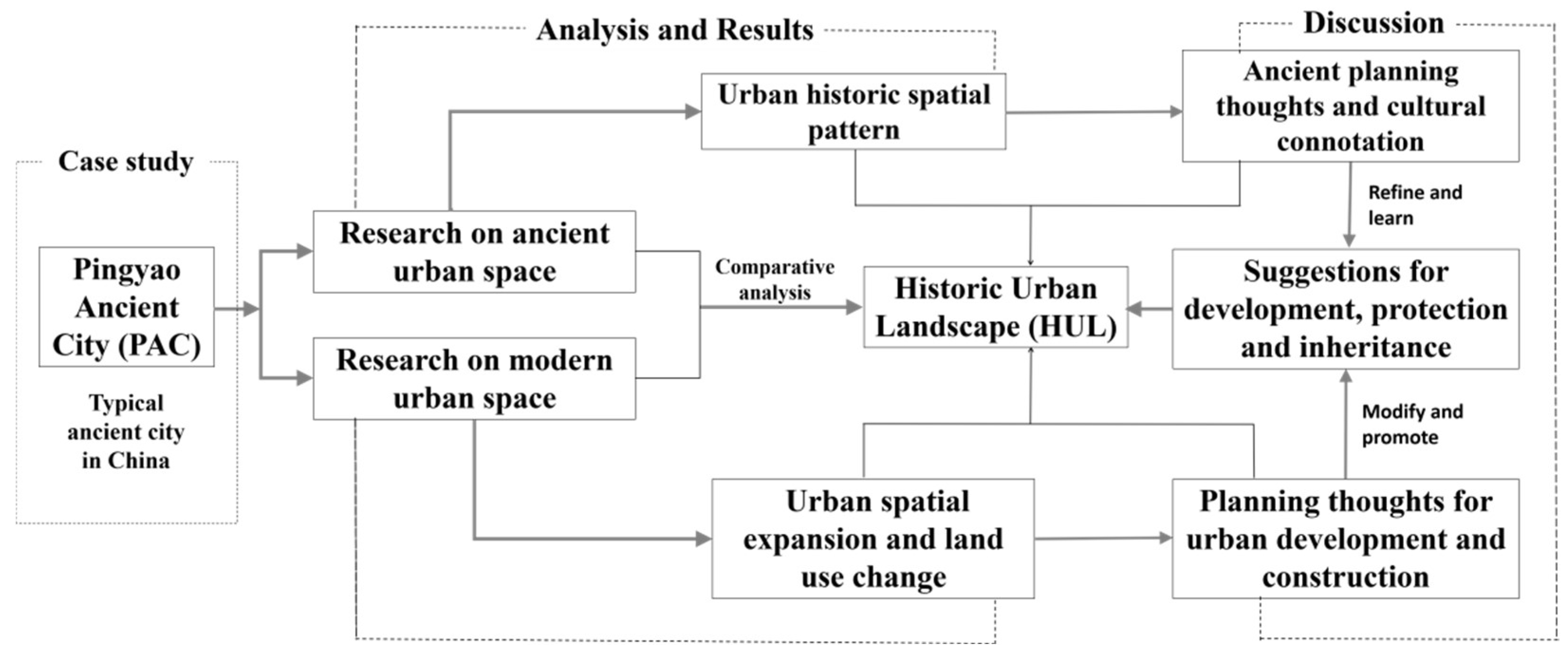
2. Materials and Methods
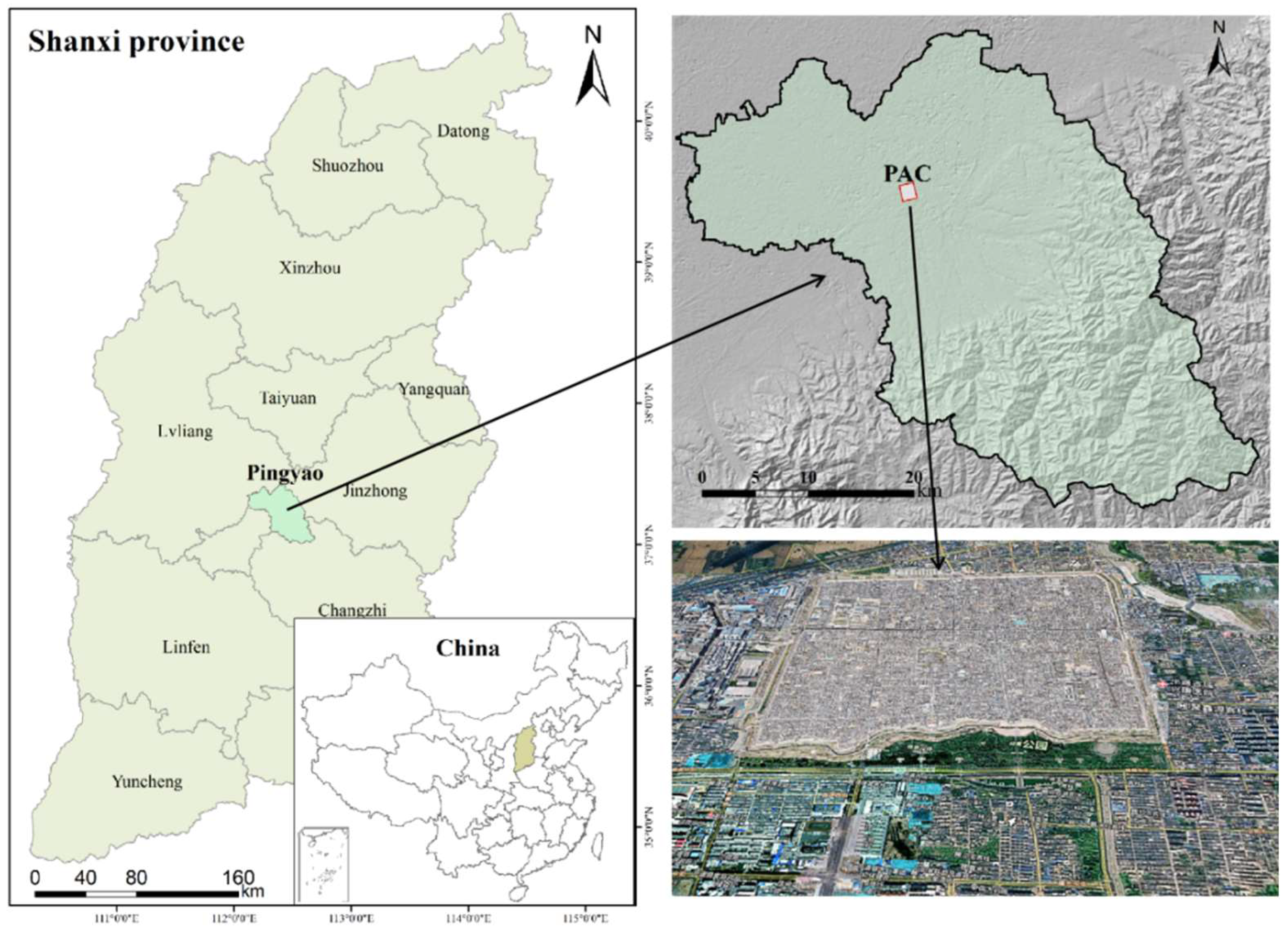
Taking a typical ancient city in China (Pingyao Ancient City (PAC)) as a case study, we adopted a comparative analysis of its historic pattern and modern expansion to show the trajectory of the urban development with respect to both the planning idea and spatial structure. The key question we sought to answer is how might the historic cityscape of PAC be maintained in such a way that it can be adapted to the needs of modern urban functions in a rapid urbanization process. The main analysis method adopted in this paper is the comparative analysis of ancient and modern urban spatial information in order to reveal the problems and causes of historical urban landscape destruction. We take the year 1949 (in which People’s Republic of China was founded) as an important dividing time point for the urban development periods of Pingyao, and then compare its urban structure and the planning ideas in different time periods. In order to analyze urban development before 1949, historical documents, ancient maps, local chronicles, and other first-hand materials are collected and the descriptions of the spatial pattern of the ancient city, as well as content that can reflect the ancient city planning and construction ideas, are explored to give an overall comprehensive overview of Pingyao ancient city. For urban development after 1949, the urban expansion and spatial patterns are further quantitatively analyzed using multi-temporal land use maps and master plans, especially after the year 1978 (in which China’s reform and opening up started). Through comparison of the urban spatial pattern and planning ideas in these two periods, we aim to identify the core issues that may cause conflict between historical protection and the modern development of Pingyao. Both planning thoughts in the ancient and modern time periods will be discussed to give suggestions for future urban development and historic cityscape protection (Figure 1).

2.1. Study Area

Pingyao city is located in the middle of Shanxi province adjacent to the Fen River which is the main river of Shanxi Province, being embraced on three sides by mountains (Taiyue Mountain in the north, Taihang Mountain in the east, and Lvliang Mountain in the west). Pingyao Ancient City (PAC) as one of the four most well-preserved ancient cities, is the most complete and unique historical city in China that reflects the Han cultural characteristic [28,29]. The PAC is located in the northwest of Pingyao, covering an area of about 2.25 km2, with a history of more than 2700 years [30,31] (Figure 2).

2.2. Exploration of the Historical Urban Landscape of Pingyao

Before 1949, the urban space of Pingyao experienced a long and stable historical period. A relatively stable urban structure and landscape pattern formed in the PAC and its natural environment has been maintained for thousands of years [27,32]. For the construction of urban and rural spaces in ancient China, great attention has been paid to the spatial connection between cultural and natural elements. The ancient planners were skilled at giving this connection a specific cultural connotation. In this way, the deep connection of the urban and rural residents in the region is established in the cultural identity, thus forming the continuity of the urban and rural cultural landscape within the region [33]. Therefore, we consider the ancient city and its surrounding areas as a complete spatial structure rather than a dense heritage group. To understand the urban planning and construction idea of Pingyao before 1949, we collect and explore the related content in the existing historical documents and local chronicles for qualitative analysis. With additional comparison to some ancient maps, we can draw some conclusions regarding its spatial characteristics and the planning thoughts of PAC.
The PAC as a settlement with high cultural added value indicates the cultural consciousness and emotional memory of both the individual and the community [34,35]. Its spatial structure was formed at different spatial scales derived by local culture. Nature is the carrier of this formation process [36]. The construction of PAC was influenced by Confucian principles in terms of a subordinated social order, and by Taoism in terms of the unity of heaven, earth, and people in the cosmos [37]. Its urban structure is not only vertically stratified in time, but also horizontally structured in space, which extends and affects the modern urban space. From the historical documents, we can further understand the PAC landscape from the description of ancient people from the aspect of the natural environment, spatial patterns, and cultural intentions of the city.

2.3. Analysis of the Modern Development of Pingyao City

The year 1949 is generally considered as the starting year for modern urban development in China, although urban expansion did happen in some Chinese cities before 1949, especially in coastal areas. After 1949, urban expansion showed a completely different form of development and construction style [38]. It could also be regarded as the process of modernization of Pingyao’s urban space [39]. Such a process changes not only the physical environment, but also people’s lifestyles and values.
The change of urban land use is the key for us to analyze the problems in the protection and development of PAC in the process of modernization. We used the multi-temporal land use maps of Pingyao to calculate the increased urban area and expansion speed for each period and further analyzed the urban expansion in eight directions taking the PAC center as the center of the whole city (Figure 3). To better understand the spatial and temporal characteristics of Pingyao’s rapid urban expansion, we will combine the expansion speed and direction of urban space, as well as the changes in urban structure, then analyze the destruction and dissolution of the integrity of Pingyao’s historic urban landscape. A detailed comparison and discussion of four editions of the urban master plan in the modern development of Pingyao and the ideological connotation of the ancient urban planning and construction will be conducted. Essential methods and ideas that are used in ancient urban planning are extracted for integration into the modern urban planning.

3. Results

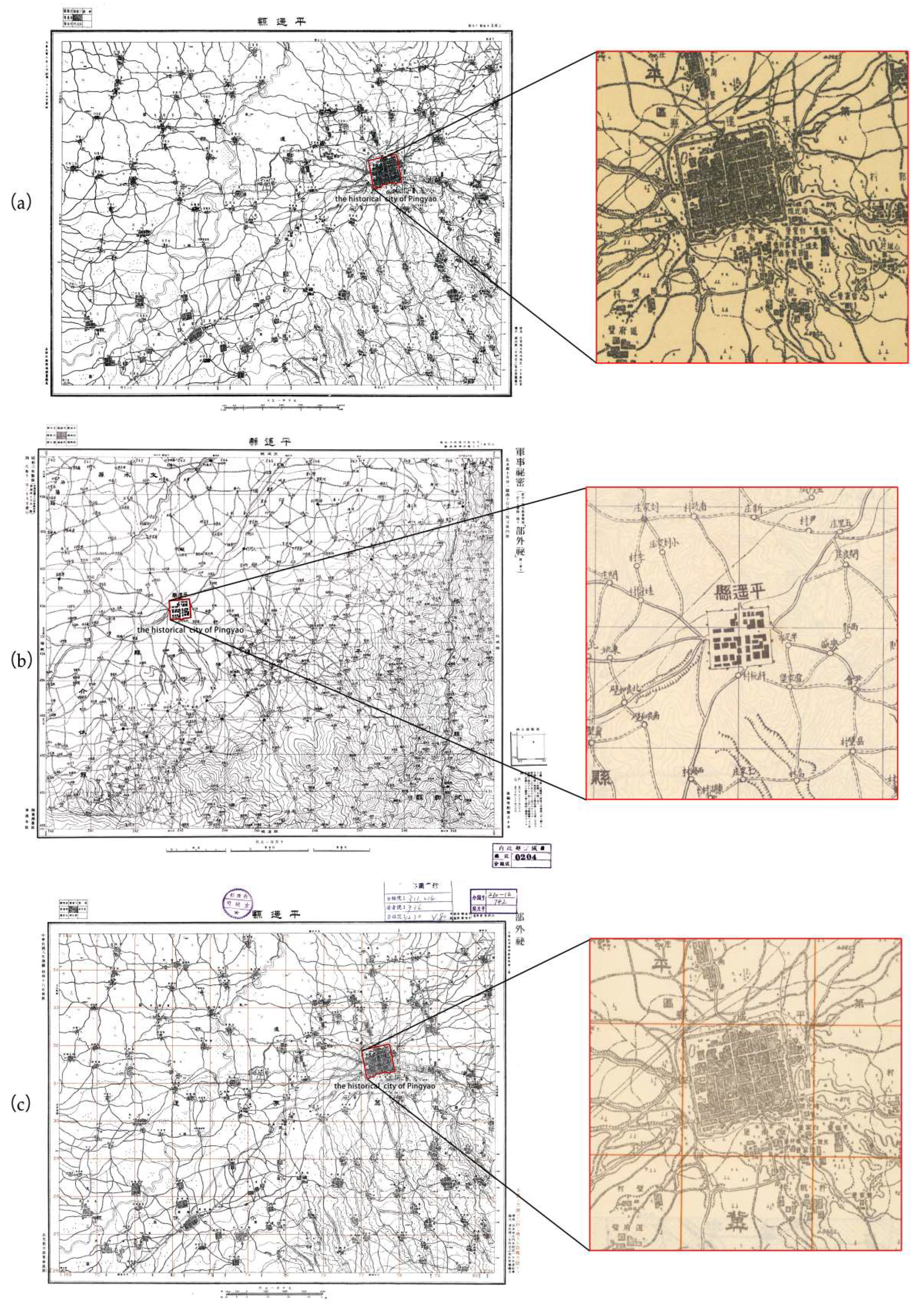
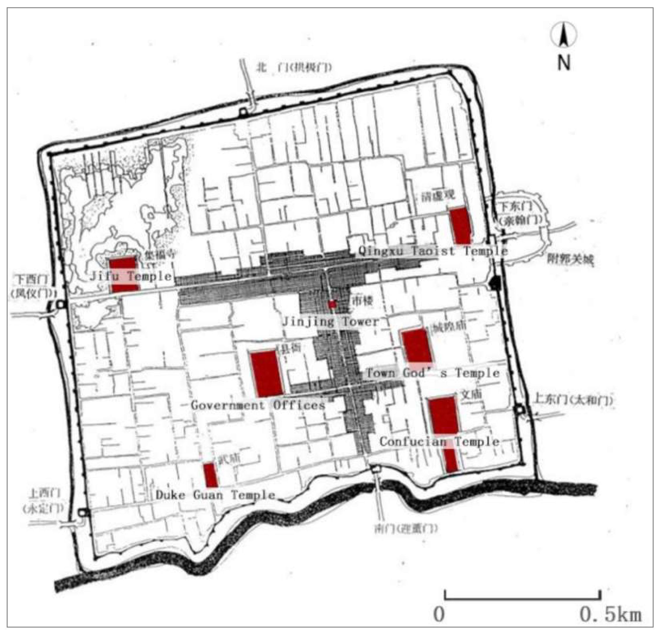
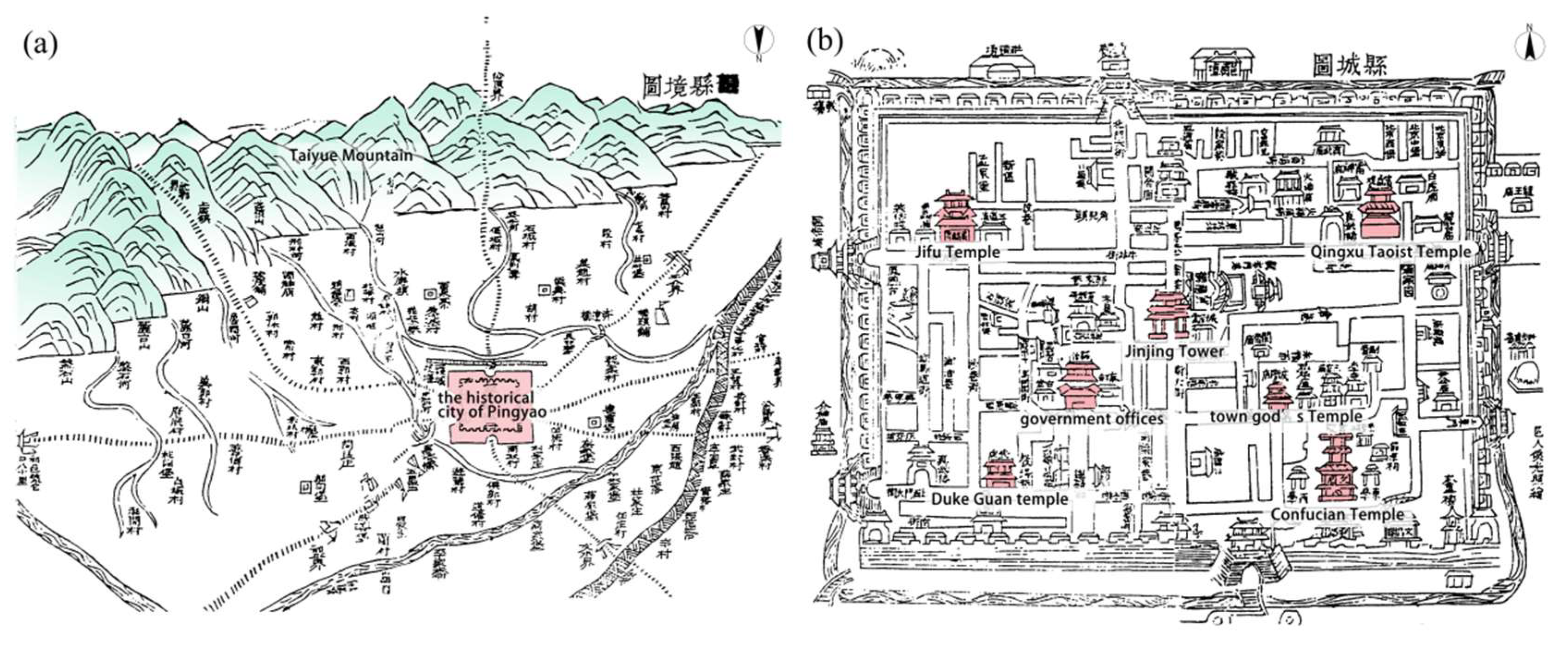
3.1. Historical Development of Pingyao City

The natural landscape of the PAC has in the past been described as “the mountains southeast fall on top of each other and are extremely steep, the gully uneven, the rock one color” [40]. Such a poetic description reflects the ancients’ attention to the natural environment outside the city and the importance of the integrity of the cultural landscape. Additionally, the Huiji River and Liugen River, which is called the Zhongdu River in the ancient time, are located in the east and south of Pingyao and also have a coordinated spatial relationship with the PAC. The orientation and shape of the PAC largely conforms to the distribution trend of the river. The spatial pattern of the PAC is based on its relationship with the river, as described in the “record on the regulation of Zhongdu River” which was written by Lei Jie, a Chinese scholar in the Qing Dynasty: “the river (Zhongdu River), from the south of the city, goes around the city and eventually into the Fen River. The east, west and north sides of the city are linear and independent, but the south side is different from the other three sides. The city is like a turtle, close to the river” [41]. He described the relationship between the city and the river as the “turtle” before the river and the river runs to the sun. The “turtle” serves as a metaphor for the city, and the landscape outside the city is likened to a recreational place for the turtle. This anthropomorphic description of the city and the surrounding natural landscape reflects the cultural attributes of the urban space, and the natural environment as the medium for constructing this cultural emotional relationship (Figure 4a).
Figure 4b shows a closely interconnected pattern of the urban space inside the PAC. Taking South Street as the axis, a symmetrical urban layout is shown: the Town God’s temple is on the left, and Government office of Pingyao County is on the right; the Confucian temple on the left, and the Duke Guan temple on the right; the Qingxu Taoist temple in the east, and the Jifu temple in the west. The city as a whole is laid out in the shape of “干”, showing a strong sense of axis order [42]. The main north–south axis of the city presented a clear spatial relationship with the natural landscape outside the city in the south direction. Such a pattern strengthens the connection between the city and the southeast mountains. The building “Jinjing Tower “, located at the key point of the South Street is the landmark for establishing this connection. As written in “record of Rebuilding the Jinjing Tower” by Zhao Qiande during the Qing Dynasty [43].
“Looking south from the city building, leaning against the railing, looking out at the southeast mountains, the clear river in the northwest, looking up at the changes of smoke and clouds, facing the prosperity of the city, understanding the surplus of the heavens, and observing the people’s praise, are there any people who are silent and sigh quietly? Not specifically. When you hear the flute of the mountain pasture, you will think about how the cattle and sheep can be healthy, and when you see the fishing boat in the Yuanpu, you will think about how the raging billows? Looking down at the lights and the bazaars, thinking about how to nurture and protect the people, I always cherish the General Ji Fu’s heroic martial arts, and dream about the ideology of the thinker Bu Shang. Looking around, the song is in your ears, and you are deeply touched by his teachings. Sincere love to people, burst and flourishing, artistic conception of the world and distant, this is indeed the great fortune of this building”.
This description is a high-level summary of the spatial correlation between the ancient city of Pingyao and the surrounding environment. It reflects the cultural and emotional connection of various spatial elements, e.g., natural elements, urban space, historical figures, and people’s livelihoods, which are displayed through the cultural landscape and spatial structure. This urban planning idea, which connects the physical space to a spiritual place, reflects an ancient Chinese planning and design wisdom that is rather different from modern urban planning. By enhancing the relevance of spatial elements, the spatial structure and cultural landscape, represented from the regional scale to the urban scale, even to the local scale within the city, are the essence of the historical urban landscape of Pingyao. From the ancient literature, we can see that the historical urban landscape of China’s historic cities is not the stacking and piecing together of a group of historical heritages, but the inheritance and continuation of traditional urban spaces from aspects of the natural environment, urban patterns, and human emotion.
Tracking back to the Ming and Qing Dynasties, Pingyao was an important commercial and financial city in northern China. It was named “silver” Pingyao and its financial services were well-known throughout the country. However, as a well-known trade center in Shanxi province, prosperous commerce did not accelerate its urban expansion, nor did it promote Pingyao’s industrial development. Pingyao’s commercial and financial activities were still based on an agricultural economy. According to the survey map of Pingyao produced in 1919 by the Administration of Land Survey of Republic of China, and the maps reproduced by the Japanese in 1933 and 1941, we can see that the main urban area of the city did not break through the wall of PAC, although there were some construction areas outside the east, west, and south gates of the PAC (Figure 5).

3.2. Modern Development of Pingyao City

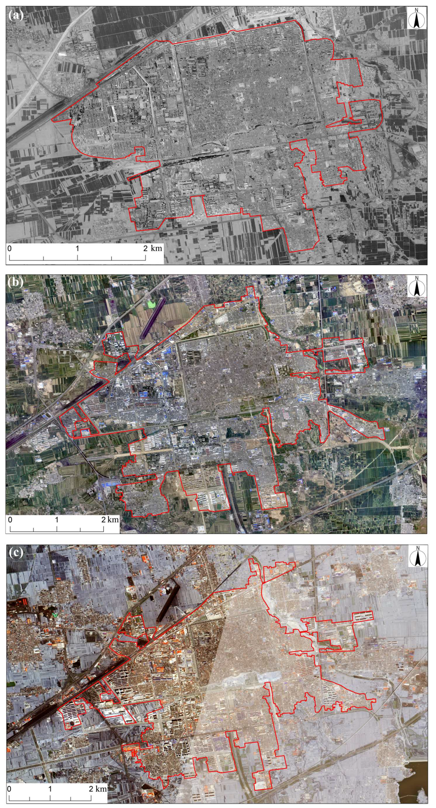
3.2.1. Rapid Urban Expansion of Pingyao City

As the social environment entered a relatively stable period after 1949, the urban area in Pingyao consequently began to gradually break through the wall of PAC to the west. However, its spatial growth was still quite slow before the 1980s. The area of PAC (c.a. 2.25 km2) can be regarded as the size of urban space of Pingyao in 1949. Until the end of the 1970s, its urban space had just grown to 3.2 km2. In 20 years, the urban space expanded by about half of the original size. The city walls on the south, east, and north sides were still the border of the urban space. In the west direction, a new urban area had gradually developed due to the attraction of a new railway station. However, the major urban functions were still concentrated in the PAC at that time. Its main primary schools, middle schools, public facilities, sanitation, and commercial facilities were still located in the ancient city. As shown in Figure 2, the urban expansion process is relatively slow before the 1980s. The year of 1978 was the initial year of China’s reform and opening up, after which China entered a rapid urbanization period [44]. The urban size of Pingyao in 2020 has increased to around four times its urban size in 1981. The commercial facilities and public park around the railway station in the southwest have become the construction engine of the new urban area. Before the 1980s, the main development direction of the city was westward. A new urban area was gradually formed outside the PAC’s west side. From 1981 to 1999, the urban space further developed from west to southwest, and the new urban area far exceeded the area of PAC. Since the beginning of the 21st century, the southern area outside the PAC has largely turned into urban construction land, and the development direction has also shifted to the south during this period.
A quantitative analysis of the urban expansion from 1989 to 2016 can help to explain the rapid urbanization process in Pingyao. According to statistical analysis (Table 1), the area of urban expansion (5.15 km2) in the period of 1999–2009 is the largest, and the expansion speed (0.52 km2/year) in this period is also the fastest. From 1989 to 1999, it shows a relatively slow expansion speed of only 0.04 km2/year. After 2009, the urban expansion speed is stable at 0.27 km2/year. We set the location of the government of Pingyao as the center to analyze the urban expansion in eight directions. From 1989 to 1999, the urban area of Pingyao did not expand significantly. Most expansion areas are in the south and southwest direction, which are respectively 0.18 km2 and 0.11 km2. From 1999 to 2009, the urban area of Pingyao expanded in all directions, with the largest expansion area (1.30 km2) in the southwest direction. The expansion areas are limited in the northeast direction due to the blocking effect of the river. From 2009 to 2016, urban expansion was concentrated in the south and southwest directions, where the urban area has increased about 1 km2. In general, the city is developing in a southwesterly and southerly direction. In the northeasterly and northwesterly directions, the Kuaiji River and a railway acted as a block to further urban expansion. From the perspective of changes in urban form, the expansion of Pingyao’s urban space did not follow a specific logical or structural order. The expansion direction of urban space is generally following land use conditions or development needs. The urban expansion in each period seems to only meet current functional needs and does not show a shaping of the relationship between urban form and its structure. This is obviously different from the practice of emphasizing the relevance of urban spatial structure during the construction of the ancient city of Pingyao in history.

3.2.2. Changes of Land Use Patterns in Pingyao City

Since Pingyao was listed as a World Cultural Heritage Site in 1997, Pingyao became an internationally renowned tourist city. As a result, the urban functions of the PAC gradually changed. Some important public facilities moved to the new urban area outside the PAC. The PAC was transformed into a large-scale tourist site [45]. For the economy, most residents of PAC increasingly participated in tourism activities to obtain the benefit of these [46]. From the perspective of land use change, the utilization of urban land space became more diversified and complicated. After the 1980s, land use for commercial facilities, public service, and parks significantly increased. Before the 1980s, there were almost no public green spaces in Pingyao. By the end of 2020, the area of urban public green land had increased to 93 ha accounting for 5.12% of the total urban area. The area for public facilities has exceeded 160 ha which is nearly triple compared to its size in the early 1980s, and the industrial area accounts for 10.5% of the total urban space in 2020. Unlike the construction and planning of PAC, which emphasized the spatial connection to natural landscape, the newly developed urban space has lost its spatial structure and seems only intended to meet the needs of economic and social development.

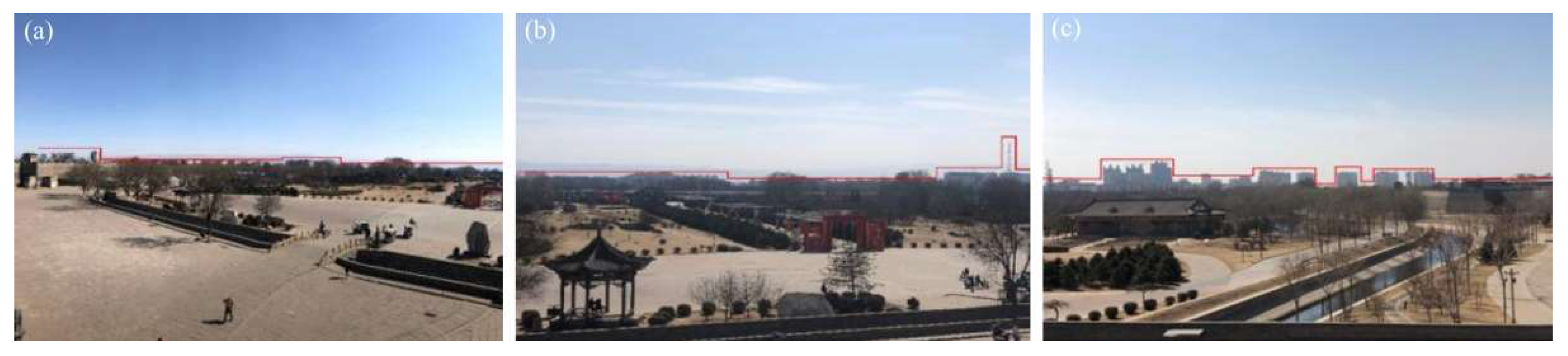
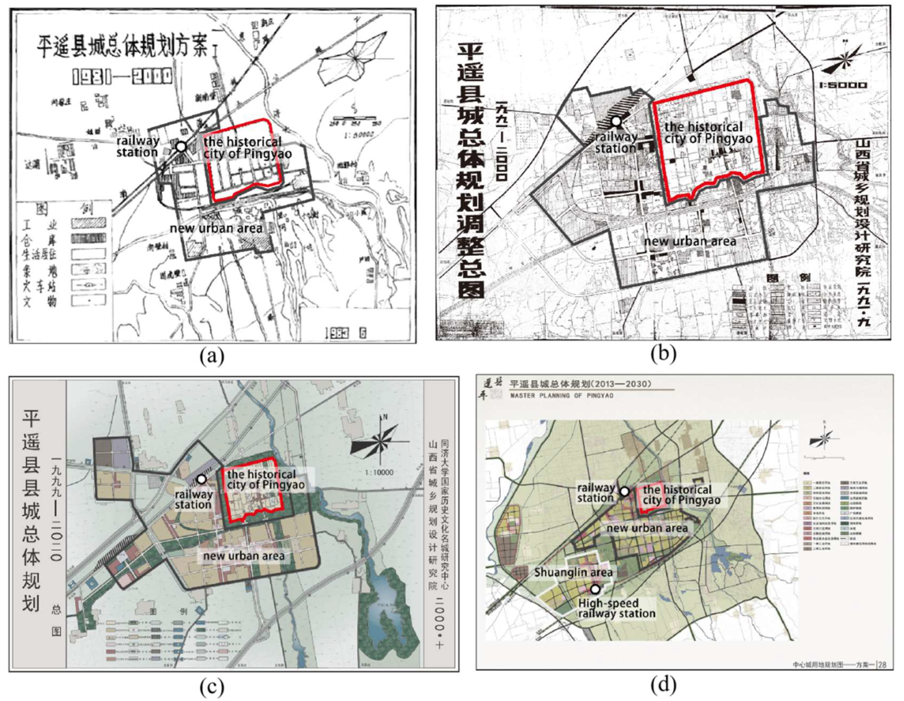
3.2.3. Changes in the Urban Spatial Structure of Pingyao City

In last 40 years, the developing center of Pingyao has shifted from the PAC to the new urban district. The ancient city has lost its multiple functions as a city and has transformed into a tourist site. In fact, this is in line with one of the local government’s intentions. Since Pingyao was identified as a World Cultural Heritage Site in 1997, the main public facilities in the PAC began to move outside of the city. The population in PAC has also been restricted, and the population would eventually be controlled below 25,000 to avoid excessive damage to the ancient city’s environment. To ensure the overall protection of the ancient city, a green belt surrounding the wall of the PAC was built, and the long-abandoned moat was also restored. In November 1999, very detailed regulations were issued by the local government for the protection of the historical heritage, the construction of related facilities, and the improvement of the living environment in the PAC [47]. Various protection measures are indeed helpful for preservation of the PAC. However, there seems to be much less value placed on the continuity of the traditional urban pattern and cultural landscape on a city-wide scale and Pingyao as a whole has not been protected, such as the ancient city itself. First, the PAC’s existing spatial axis formed by north and south streets and their extensions have not been further continued, as the southern part of the city is the main area for urban expansion. Second, the urban planners neglected the importance of the large-scale sight-line connection between the urban space and the mountains in the southeast. A large number of residential buildings appeared to the south of the ancient city wall where the main composition of Pingyao’s urban public green land are also located. The emergence of high-rise residential buildings blocked the spatial visual connection between the ancient city and the mountains in the southerly direction (Figure 6). This spatial connection, which had existed for nearly a thousand years, was broken in just a few decades.
From the perspective of the urban structure, the settlement area on the west side of the PAC is generally considered to be a new urban area separated from the ancient city. However, there is no clear boundary between them. The new urban area is located close to the west wall of the PAC, and it does not show any continuation of the east–west axis of the ancient city. The traditional urban structure in the form of “干” has not been reflected in the construction of the new urban areas. According to the master plan of Pingyao published in 2020, there is still no clear urban structure. Instead, we find random urban structures under the guidance of city functions. Some tourist facilities were built in the name of cultural development and more projects were implemented to obtain economic benefits or enhance the market value of tourism resources through the gimmicks of the ancient city. These constructions do not seek the structural connection with the PAC from the perspective of cultural landscape or historical relevance. A typical example is the “See Pingyao Again” theater on the west side of the ancient city. This amusement facility is the largest tourist facility (with an area of 23 ha) newly built in Pingyao and includes a performance venue, service supporting area, commercial streets, and parking lots. Due to its closeness to the ancient city, such a large tourist facility with the capacity for such a large volume of visitors is extremely likely to damage the historical environment of the ancient city, despite the entire building not exceeding the height control of 15 m. In fact, this is the most prominent contradiction between the historical urban landscape and the development of modern urban space. The fragmented spatial distribution and lack of integrity can be identified in terms of the spatial layout of the urban structure of Pingyao (Figure 7).

4. Discussion: Ancient Planning Thoughts and Modern Urban Planning

4.1. Ideology of Ancient City Construction in China

Based on the spatial pattern of the PAC and planning idea on urban construction described in historical documents, we can see that the establishment of the relationship between the spatial elements from urban and nature through structural means are emphasized in ancient Chinese urban planning. A set of urban morphological relationships with specific logic is formed by selecting location and orientation for some important buildings in the public space, such as government offices, Confucian Temple, Duke Guan Temple, Qingxu Taoist Temple, ancestral hall, and so on. The orientation of these key buildings is consistent with the axis of the PAC. Regarding the location of the buildings in the PAC, the Confucian Temple and the Duke Guan temple are located in the southeast and southwest of the ancient city, respectively, while the Qingxu Taoist Temple is in the northeast and the Jifu Temple is in the northwest. The Confucian Temple and the Duke Guan temple respectively represent the cultural Confucianism and military loyalty advocated by the city, while the Qingxu Taoist Temple and the Jifu Temple respectively represent Taoist culture and Buddhist culture. The government office and the town god’s Temple are also located in the eastern and western parts of the city, representing secular power and the power of the gods. This symmetrical layout strengthens the overall relationship between the city’s culture and structure. City Tower, also known as the Jinjing Tower, is located in the urban center, dominating the entire urban space and strengthening the structural integrity of the landmark buildings (Figure 8).
Some scholars would habitually regard this urban construction method emphasizing spatial connection as a manifestation of ancient Chinese “ritualism”. However, according to ancient literature records, this view is one-sided. As described before, Jinjing Tower is closely related to the natural space outside the city. Mountains, rivers outside the city, streets, and houses inside the city could be connected through this core landmark. The structural connections between Jinjing Tower and other buildings in the PAC promote an indirect spatial relationship between the overall structure of the PAC and the natural environment outside the city, thereby enabling the entire PAC to interact with the natural environment in space. As the orientation of the entire PAC and the main buildings in the city are all towards the southeast, this forms a large-scale contrasting relationship with the southeast mountain. These multiple spatial connections show the ancient Chinese people’s desire to integrate themselves with nature as a whole in the construction of cities. To this day, the unique historical urban landscape of Chinese ancient cities can still be seen. It could also be summarized as a unique Chinese landscape consciousness, as Jie Lei (a Chinese scholar in the Qing dynasty) wrote [41].
“Nature, is our real father and mother. Mountains and rivers, just like parents’ breath, blood, even life. The investigation and site selection of urban construction must conform to the laws of nature, so as to truly benefit the people. This is no longer simply a matter of management or defense.”
This description expresses the urban planning awareness that emphasizes respect and protection of nature during the construction process. It also succinctly summarizes the essence of ancient Chinese city construction. This kind of thinking is far beyond any so-called “ritual system”. It reflects the high correlation between urban space and natural environment, which could be seen from the relationship between urban form and surrounding landscape elements in the structure of Pingyao. It also shows the ancient people’s clever use of natural elements reflected in the design and build of their own ideal urban living environment [48].
However, this urban construction tradition that lasted for more than a thousand years has not been continued and passed on during the process of recent rapid urbanization and urban sprawl. Although the ancient urban area is well preserved, its relationship with the new urban area is becoming more and more fragmented. The integrity and connection of the urban structural form has not been emphasized. This also results in the destruction and dissolution of the historic urban landscape. The spatial relationship between the urban area and its surrounding mountains and rivers seems to be weakening, and the city’s historical and human spirit has been forgotten. In order to discuss this problem in depth, we will highlight several important urban planning editions of Pingyao since the 1980s and discuss each further.

4.2. Modern Urban Planning

The first city master plan of Pingyao in the true sense was compiled only after the reform and opening-up policy in China, namely the 1981 edition of the Pingyao County Master Plan. There was a huge debate on the issue of whether the ancient city of Pingyao should be protected or completely demolished to make room for urban development at that time. With the support of the Ministry of Culture and Tourism of China, the planning idea of comprehensive protection of the ancient city was adopted in the master plan at that time. It was proposed to divide the city into two independent parts, the PAC and the Southwest New District, so as to realize the development idea of a new separation of urban space. Such an idea was quite important for the preservation of historical cities throughout China. Later, in many historical cities in China, the concept of separation of the old and the new was applied to protect the historic urban areas [49,50,51,52]. The separation of the old and new urban areas was intended to ensure that there was enough space between the new urban construction and the old urban areas to avoid damage to the historic urban areas due to the needs of city development. However, in this plan, the urban layout mainly focused on the needs of urban space development and did not really explore the spatial relationship between the old and the new urban area. The new urban space with the railway station spread outwards outside the ancient city as the center, and it had no sense of unity with the ancient space form at the structural level. The following master plans, the 1989 and 1991 editions, continued the urban layout in terms of historical urban area protection, and further encouraged the city to develop towards the southwest and south to the new urban areas. A development strategy of “double rings and double centers” was proposed during this period. The basic pattern of Pingyao’s urban spatial development was thus established. In the master plan of 1999, previous planning concepts were optimized and a multi-group development idea was proposed, but the spatial pattern of the double centers did not change substantially. In the master plan of 2013, the development idea of preserving the harmony between the old and the new urban areas was put forward. At this time, the planners began to realize that the development model for separation of the old and the new urban areas ensured the protection of the ancient city to a certain extent, but it also caused a spatial division between the new city and the ancient city. This version of the master plan attempted to build a harmonious relationship between the old and the new city, so as to alleviate the problem of spatial division of Pingyao. However, in terms of the land use layout, no effective detailed plan was proposed. At the same time, in order to alleviate the problem of urban land shortage, another complete new urban area was planned around Shuanglin Temple in the southwest of the city. This approach undoubtedly has no real benefit in shaping the harmonious relationship between the new and ancient urban spaces. Considering the actual situation of Pingyao’s urban spatial development, this harmonious concept has not yet been realized.
Comparing the different editions of the master plan and the development process of urban land space in Pingyao (Figure 9), we could see that the urban spatial development pattern was basically formed in its first master plan issued in 1981 and was further established in the late 1990s. The subsequent editions of the master plan were just to conform to the trend of urban space development, and did not deeply explore the structural role of the ancient city in the development of modern urban spaces. As a result, the ancient city gradually became an isolated landscape remaining in the urban area. The ancient urban construction experience and traditional thinking were hardly seen in the modern planning. Meanwhile, land outside the ancient city that had the potential for urban construction was included in the scope of the new urban district. The so-called “separation of the old and the new urban” had gradually turned into a situation where the new urban area encircles the old one, indicating the ancient city and the new urban area are separated in structure, but still connected in space. Nevertheless, these master plans have played a positive role for urban development and ancient city protection. Ancient and modern urban plans are greatly different in emphasis and cultural background. Ancient planners paid much attention to the inheritance of culture and the harmonious relationship between city and nature. Modern planners put more emphasis on responding to development issues and addressing various spatial demands caused by urban expansion, even the protection of ancient cities is a passive response. This could be the reason why the PAC was surrounded by the new urban area, but it had not formed a structural connection between them. It applies not only to Pingyao, but also the overall destruction and continuous decline of the historic urban landscape of many historical cities in China.

4.3. Suggestions for Development, Protection and Inheritance

In the current conference on the urban space development in Pingyao, the authors had proposed the planning idea of “highlighting the pattern of ancient city and reconstructing modern space with historical structure”. The ancient construction experience should be reproduced in modern planning techniques. Correspondingly, five specific planning strategies are presented: (1) Strengthen the north–south axis centered on the “City Tower” in the ancient city. (2) Enhance the status of key landmark buildings in the urban public space system in the ancient city. (3) Establish a control and guidance system of the urban landscape. (4) Reshape the sight corridors between landmark buildings and natural landscape elements outside the city. (5) Finally, formalize a complete set of landscape management and guidance systems for the entire urban space. On the basis of inheriting Pingyao’s ancient urban planning ideas, modern urban planning techniques should be integrated to connect the historical ancient city and today’s new urban spaces through spatial means. The aim of implementing these strategies is to highlight the structural role of the PAC, and integrate its traditional pattern into the new urban space to form a whole cityscape. We are not trying to restore a certain historical method of urban construction, nor fall into a kind of urban development conservatism. The key is to find the role of the ancient city in today’s urban space. In fact, history and contemporary times are not opposites. History was once contemporary, and today’s contemporary will one day be history. We should neither fall into history and be unwilling to face the changes of the new era, nor ignore the deep connection between history and today. Regarding the development of Pingyao’s urban space and the efforts made by planners, we believe that it is not enough to preserve the historical space. More importantly, we must explore the wisdom of historical space construction to find a way to integrate ancient construction ideas into urban planning in modern times. Other researches have also explored the issue of Pingyao’s historic urban landscape, but focus on the current heritage protection and tourism from a perspective of economic and social development [27,29,30,32]. In this paper, we discussed the ancient urban planning ideas and construction pattern of Pingyao, analyzed the difference between ancient urban planning and modern urban planning, and compared the core ideas of the previous editions of the spatial planning of Pingyao. The proposed suggestions have been adopted by the local planning authority and partially incorporated into the relevant sections of Pingyao’s spatial planning. The outcomes of this research have become an important part of the technical achievements of Pingyao’s future urban development and protection.

5. Conclusions

In this paper, we compared and discussed the urban spatial structure in different spatial-temporal contexts. The aim is to correct a long-standing misconception in China that the maintenance of historical heritage alone is not enough for the overall preservation of historical and cultural landscapes. The decline and dissolution of the cultural landscape and traditional spatial structure of the ancient city of Pingyao does not mean that the heritage has not been protected, or has been demolished. Rather, it refers to the destruction of a spatial connection containing profound cultural emotions established by the ancients. It includes not only the separation from the natural environment caused by the excessive construction outside the ancient city, but also the disorderly development caused by the lack of basic understanding of the traditional urban structure. What happened in the ancient city of Pingyao is the epitome of the experience of historical cities in various regions of China. As the ancient city of Pingyao is well-preserved, such conflict in its urbanization process is more significant than in other historical cities in China.
In the construction of ancient Chinese cities, rich planning experience has been accumulated. At present, it is still in its infancy to explore the protection and development of the historical urban space through historical research in China. This paper examines the cultural connotations and spatial characteristics behind Historic Urban Landscape (HUL) by summarizing the ancient urban planning experience and analyzes the ideas of urban space construction. It is of high importance to integrate such experience and ideas into current planning practice. Based on the comparison of the spatial structure of Pingyao city in two time spans, we find completely different construction ideas and planning thoughts in ancient and modern times. It could be the fundamental reason for the destruction of the historical urban landscape of PAC. However, due to the limitations on the historical maps and corresponding instructional texts, we can only understand the ancient planning thoughts through some poetic description. This may not be enough to reflect the whole picture of the ancient planning process. A next step could be for additional literatures and data sources from other ancient cities in China to be collected and a joint analysis undertaken for a better understanding of the ancient planning process in different regions and different temporal scales. This could be important for achieving a sustainable and continuous cityscape, especially in a rapid urbanizing stage.
The historic urban landscape of the Chinese ancient city is not just an independent unit isolated from the external environment, but a dynamic landscape that is always related to its environment. For the preservation of historic cities in China, it must be based thinking about building Chinese historical spaces and recognizing the cultural role of the heritage in a holistic perspective, rather than treating them as isolated exhibits or commercial goods. It is undeniable that Pingyao, a small city in China, has gradually transformed into a modern city in the development process of nearly 40 years, and has presented a diversification of land uses. However, the negative consequences of a lack of respect for the historical urban landscape might be difficult to make up for with short-term economic gains. It will always be an important issue and a core content of China’s urban planning in the near future to consider how to develop a new mode of urban planning and construction that gives consideration to urban spatial growth, preservation of historical landscape, and cultural inheritance in the new era.

Author Contributions

Conceptualization and Methodology, X.L.; Data analysis, X.L. and W.H.; Writing—original draft, X.L.; Writing—review and editing, M.L. and Z.Y.; Supervision and Proofreading, W.H. All authors have read and agreed to the published version of the manuscript.

Funding

This research was funded by Youth Fund of National Natural Science Foundation of China (grant number 52008326) and the Basic Research Funding in CASM (grant number AR2113).

Institutional Review Board Statement

Not applicable.

Informed Consent Statement

Not applicable.

Data Availability Statement

The data in the article is detailed in Section 3.2. All the data used are reflected in the article. If you need other relevant data, please contact the author.

Acknowledgments

The authors would like to highlight the contributions from Department of Housing and Urban-Rural Development of Shanxi Province and Shanxi Institute of Surveying, Mapping and Geoinformation by providing land use maps, master plans, aerial images, etc.

Conflicts of Interest

The authors declare no conflict of interest.

References

  1. UNESCO. Vienna Memorandum on ‘World Heritage and Contemporary Architecture-Managing the Historic Urban Landscape’; UNESCO World Heritage Centre: Paris, France, 2005. [Google Scholar]
  2. UNESCO. Recommendation on the Historic Urban Landscape; UNESCO: Paris, France, 2011. [Google Scholar]
  3. Bandarin, F.; Oers, R.V. Reconnecting the City: The Historic Urban Landscape Approach and the Future of Urban Heritage; John Wiley & Sons: Oxford, UK, 2015; pp. 301–315. [Google Scholar]
  4. Liu, Y.F. A Summary of 10 Years of Historical Urban Landscape Research in China. Chin. Landsc. Archit. 2016, 32, 74–77. [Google Scholar]
  5. ICCROM In Proceedings of the World Heritage and Contemporary Architecture and Development: Management of the Historic Urban Landscape in the Baltic Countries, Vilnius, Lithuania, 7–8 December 2006. Available online: https://whc.unesco.org/document/9017 (accessed on 10 December 2021).
  6. Wu, Q.Y.; Cheng, J.Q.; Young, C. Social differentiation and spatial mixture in a transitional city—Kunming in southwest China. Habitat Int. 2017, 64, 11–21. [Google Scholar] [CrossRef] [Green Version]
  7. Liu, F.; Shi, L.F.; Zhang, Z.X.; Wang, X. Urban expansion modes of major cities in China in the past four decades. In Proceedings of the 4th International Workshop on Earth Observation and Remote Sensing Applications, Guangzhou, China, 4–6 July 2016; pp. 193–197. [Google Scholar]
  8. Gu, C.L.; Wu, L.Y.; Ian, C. Progress in research on Chinese urbanization. Front. Archit. Res. 2012, 1, 101–149. [Google Scholar]
  9. Gu, C.L.; Chen, Z.G. The metropolitan spatial growth patterns in China. City Plan. Rev. 1994, 18, 45–50. [Google Scholar]
  10. Luo, J.M.; Qiu, H.; Goh, C.; Wang, D. An Analysis of Tourism Development in China from Urbanization Perspective. J. Qual. Assur. Hosp. Tour. 2016, 17, 24–44. [Google Scholar] [CrossRef]
  11. Li, G.D.; Li, F. Urban sprawl in China: Differences and socioeconomic drivers. Sci. Total Environ. 2019, 673, 367–377. [Google Scholar] [CrossRef]
  12. Couch, C.; Leontidou, L.; Petschel-Held, G. Urban Sprawl in Europe; Blackwell: Oxford, UK, 2008. [Google Scholar]
  13. Zeng, C.; Liu, Y.L.; Liu, Y.F.; Qiu, L.Q. Urban sprawl and related problems: Bibliometric analysis and refined analysis from 1991 to 2011. Chin. Geogr. Sci. 2014, 24, 245–257. [Google Scholar] [CrossRef]
  14. Wang, H.; Ning, X.G.; Zhang, H.C.; Liu, Y.F. Urban expansion analysis of China’s prefecture level city from 2000 to 2016 using high-precision urban boundary. In Proceedings of the 2019 IEEE International Geoscience and Remote Sensing Symposium, Yokohama, Japan, 28 July–2 August 2019; pp. 7514–7517. [Google Scholar]
  15. Zhang, X.; Pan, J. Spatiotemporal Pattern and Driving Factors of Urban Sprawl in China. Land 2021, 10, 1275. [Google Scholar] [CrossRef]
  16. Xiong, F. Reflections on the problems in the development of mid- and small-sized towns and cities. J. Beijing Inst. Public Adm. 2005, 1, 89–93. [Google Scholar]
  17. Zhou, G.; Zhang, J.; Li, C.; Liu, Y. Spatial Pattern of Functional Urban Land Conversion and Expansion under Rapid Urbanization: A Case Study of Changchun, China. Land 2022, 11, 119. [Google Scholar] [CrossRef]
  18. Chen, H.; Wang, L.L.; Waley, P. The Right to Envision the City? The Emerging Vision Conflicts in Redeveloping Historic Nanjing, China. Urban Aff. 2019, 56, 1746–1778. [Google Scholar]
  19. Arkaraprasertkul, N. Gentrifying heritage: How historic preservation drives gentrification in urban Shanghai. Int. J. Herit. Stud. 2019, 25, 882–896. [Google Scholar] [CrossRef]
  20. Whitehand, J.W.R.; Gu, K.; Whitehand, S.M. Fringe belts and socioeconomic change in China. Environ. Plan. B-Plan. Des. 2011, 38, 41–60. [Google Scholar] [CrossRef]
  21. Jiang, W.L.; Ma, C.C. Afterthought of the old summer palace restoration study on protection and development of the Chinese landscape cultural heritage based on ontology. In Proceedings of the International Conference on Humanities and Social Science, Guangzhou, China, 8–10 January 2016. [Google Scholar]
  22. Wang, F.; Mao, W.; Dong, Y.; Zhu, X. Implications for Cultural Landscape in a Chinese Context: Geo-analysis of Spatial Distribution of Historic Sites. Chin. Geogr. Sci. 2018, 28, 169–184. [Google Scholar] [CrossRef] [Green Version]
  23. Pedrycz, P. Form-Based Regulations to Prevent the Loss of Urbanity of Historic Small Towns: Replicability of the Monte Carasso Case. Land 2021, 10, 1235. [Google Scholar] [CrossRef]
  24. Dong, C. Urban historical landscape construction methods and designs: The case of the old town of Jindezhen. Open House Int. 2019, 3, 13–16. [Google Scholar] [CrossRef]
  25. Tang, M.D.; Chen, T.C. Cultural Landscape Evolution Under Rapid Urban Development: A Case Study of Shichahai Historical Area in Beijing, China. In Proceedings of the 2nd International Conference on Logistics, Informatics and Service Science, Beijing; Springer: Berlin/Heidelberg, Germany, 2012; Volume 6, pp. 12–15. [Google Scholar]
  26. Hua, X. Annals of Pingyao Ancient City; Zhong Hua Book Company: Beijing, China, 2002. [Google Scholar]
  27. Wang, S.X.; Gu, K. Pingyao: The historic urban landscape and planning for heritage-led urban changes. Cities 2020, 97, 102489. [Google Scholar] [CrossRef]
  28. Tang, C.C.; Zheng, Q.Q.; Ng, P. A Study on the Coordinative Green Development of Tourist Experience and Commercialization of Tourism at Cultural Heritage Sites. Sustainability 2019, 11, 4732. [Google Scholar] [CrossRef] [Green Version]
  29. Su, X.Y. Reconstructing Tradition: Heritage Authentication and Tourism-Related Commodification of the Ancient City of Pingyao. Sustainability 2018, 10, 670. [Google Scholar] [CrossRef] [Green Version]
  30. Han, X.X.; Zhu, X.D. Investigation and suggestion on the building environment of traditional courtyard house in ancient city of pingyao. In Proceedings of the 2018 International Conference on Advanced Chemical Engineering and Environmental Sustainability, Guangzhou, China; 15–16 2018; pp. 431–436. [Google Scholar]
  31. Kinoshita, T. The Study of Space Organization and Characteristic on Chinese Traditional Courtyard in Pingyao Ancient City. In Proceedings of the 10th International Landscape Architecture Symposium of Korea, China and Japan, South Korea, Shanghai, China, May 2007; 2007; Volume 11, pp. 168–173. [Google Scholar]
  32. Can, C.; Chignier Riboulon, F. The Touristification of the Ancient Chinese City of Pingyao, between Renewal and New Problems. Transl. China 2017, 3, 4. [Google Scholar]
  33. Li, X.P.; Wang, S.S.; Li, X.L.; Gao, Y. Regional planning based on orientation: A planning method of regional landscape human settlement pattern in ancient China. Urban Plan. 2018, 42, 69–70. [Google Scholar]
  34. Wang, S.Y. In search of authenticity in historic cities in transformation: The case of Pingyao, China. J. Tour. Cult. Chang. 2011, 9, 18–30. [Google Scholar] [CrossRef]
  35. Shao, Y.; Lijun, H.U.; Zhao, J.; Chen, H. A Research on Conservation Plan of the Human-Habitat World Heritage: Case Study of Pingyao Ancient City. Urban Plan. Forum 2016, 5, 94–102. [Google Scholar]
  36. John Leighly. Carl Ortwin Sauer. The Morphology of Landscape. Land and Life: A Selection from the Writing of Carl Ortwin Sauer; University of California Press: Berkeley, CA, USA; Los Angeles, CA, USA, 1963; pp. 317–350. [Google Scholar]
  37. Zheng, X.; Ren, Z. Report on investigation of Shanxi Pingyao. Urban Dev. Study 1996, 3, 16–19. [Google Scholar]
  38. Wan, Z.W.; Chen, X.; Ju, M.; Ling, C.H.; Liu, G.X.; Liao, F.Q.; Jia, Y.L.; Jiang, M.X. Reconstruction and Pattern Analysis of Historical Urbanization of Pre-Modern China in the 1910s Using Topographic Maps and the GIS-ESDA Model: A Case Study in Zhejiang Province, China. Sustainability 2020, 12, 537. [Google Scholar] [CrossRef] [Green Version]
  39. Liang, R.; Guo, H.W.; Liu, J.Y.; Liu, Z.Y. Scenic Image Research Based on Big Data Analysis—Take China’s Four Ancient Cities as an Example. KSII Trans. Internet Inf. Syst. 2020, 14, 2769–2784. [Google Scholar]
  40. En, R.; Wu, D.C.; Wang, S.E. The Local Chronicles of Pingyao County in Qing Dynasty of Guangxu Nine Years; Published by Pingyao County Government Office of Qing Dynasty: Pingyao, China, 1883; Volume 11. [Google Scholar]
  41. Lei, J. Record on the Regulation of Zhongdu River, The Local Chronicles of Pingyao County in Qing Dynasty of Guangxu Nine Years; Published by Pingyao County Government Office of Qing Dynasty: Pingyao, China, 1883; Volume 11. [Google Scholar]
  42. Li, X.P.; Li, J.S.; Hou, W. Research on Regional Historical Heritage Network from the Perspective of Cultural Landscape: Take the Jinzhong Basin as an Example. Urban Dev. Stud. 2020, 27, 101108. [Google Scholar]
  43. Zhao, Q. The Record of Rebuilding the Jinjing Tower, The Local Chronicles of Pingyao County in Qing Dynasty of Guangxu Nine Years; Published by Pingyao County Government Office of Qing Dynasty: Pingyao, China, 1883; Volume 11. [Google Scholar]
  44. Tsang, N.K.F.; Hsu, C.H.C. Thirty years of research on tourism and hospitality management in China: A review and analysis of journal publications. Int. J. Hosp. Manag. 2011, 30, 886–896. [Google Scholar] [CrossRef]
  45. Wang, S.Y. From a living city to a World Heritage City: Authorised heritage conservation and development and its impact on the local community. Int. Dev. Plan. Rev. 2012, 34, 117. [Google Scholar] [CrossRef]
  46. Zhang, X.M.; Cheng, S.W.; Liu, X.L.; Wang, Q.; Zhao-Hong, L.I. Spatial-Temporal Characteristics and Influencing Factors of Network Attention to Ancient City Destination: A Case of Pingyao. Econ. Geogr. 2016, 36, 196–202. [Google Scholar]
  47. Zai, Z. A brief analysis of the Chinese culture characteristics of ritualism of pingyao ancient City architecture. J. Sanmenxia Polytechnic 2007, 13, 435. [Google Scholar]
  48. Wang, S.S.; Gao, Y.; Li, X.L. A Study on the Spatial Structure of Chinese Landscaping and Culture Cities. Urban Plan. Forum 2019, 12, 732. [Google Scholar]
  49. Yang, R.Q.; Liu, Y.J. An Analysis of Datong’s Protection of Historical and Cultural City Based on Mode of Separating New and Ancient City Areas. J. Anhui Agric. Univ. 2019, 28, 121–127. [Google Scholar]
  50. Liu, L.A.; Wang, S.S. Further recognition about the pattern of “new-old separation”in the preservation of historic cities. J. Xi’an Univ. Archit. Technol. 2002, 17, 679. [Google Scholar]
  51. Wang, G.J.; Meng, L.X.; Xie, X.D. Theory and Practice of ancient City Conservation and Renewal—A case study of Liaocheng. Urban Problems 2010, 5, 36–40. [Google Scholar]
  52. Liao, B.C. On the Protection of the Ancient Town langzhong. J. Ningbo Univ. 2005, 6, 109–115. [Google Scholar]
Figure 1. Research framework.
Land 11 00247 g001
Figure 2. Location of the study area.
Land 11 00247 g002
Figure 3. Land use maps in Pingyao from Qing dynasty to 2020. (Maps provided by the Department of Housing and Urban-Rural Development of Shanxi Province).
Land 11 00247 g003
Figure 4. Landscape of the ancient city (a) and its urban layout (b) of Pingyao in year 1883. (Historical maps retrieved from the local chronicles of Pingyao County in Qing dynasty of Guangxu 9th year (1883)).
Land 11 00247 g004
Figure 5. Land survey maps of Pingyao in 1919 (a), 1933 (b), 1941 (c). (Maps retrieved from Ministry of the Interior, Administrative Department of Taiwan, China).
Land 11 00247 g005
Figure 6. Views from the south gate tower facing west (a), south (b), and east (c). (Author’s photos).
Land 11 00247 g006
Figure 7. Spatial layout of Pingyao city in 1999 (a), 2010 (b), 2015 (c). (Images provided by Shanxi Institute of Surveying, Mapping and Geoinformation).
Land 11 00247 g007
Figure 8. Spatial structure map of Pingyao Ancient City. (Adapted according to the Pingyao Historical and Cultural City Protection Plan (1989) provided by the Department of Housing and Urban-Rural Development of Shanxi Province).
Land 11 00247 g008
Figure 9. Master plan of Pingyao in years 1981–2000 (a), 1991–2000 (b), 1999–2020 (c), 2013–2030 (d). (Maps provided by Department of Housing and Urban-Rural Development of Shanxi Province).
Land 11 00247 g009
Table 1. Statistic of urban expansion in eight directions from 1989 to 2016.
Expansion Area (km2)Expansion Speed (km2/Year)
Direction1989–19991999–20092009–20161989–19991999–20092009–2016
North00.60.2300.060.03
Northwest00.28000.030
West0.030.720.1700.070.02
Southwest0.111.30.690.010.130.1
South0.180.990.360.020.10.05
Southeast0.050.560.20.010.060.03
East0.010.60.1300.060.02
Northeast0.010.10.1300.010.02
Sum0.395.151.910.040.520.27
Publisher’s Note: MDPI stays neutral with regard to jurisdictional claims in published maps and institutional affiliations.

