1. Introduction
More than half of the world’s population lives in urban areas, and it is expected that by 2050 around 68% will be urban inhabitants [
1]. Globally, Latin America nations have the second highest city-dwelling population, with 81% living in urban areas [
2], and that figure is expected to rise to 90% in 2050 [
3], with the number of cities over 1 million rising to 88 [
1]. Urbanization is more pronounced in arid lands, and this trend is expected to continue in the future—the drier the land, the larger the fraction of the population that will be living in cities [
4].
Urbanization in Latin America is driven by several factors including population growth [
2], economic opportunity, and migration to escape from violence [
5,
6]. Rapid urbanization often results in uncontrolled sprawl in the form of informal settlements—sometimes located in hazardous areas that are underserved by infrastructure—and encroaching on protected open space [
2,
6]. For local governments, rapid urban expansion poses significant challenges, including greater demand for affordable housing, a need for better access to adequate infrastructure and services, a struggle to preserve open space and natural resources, and a requisite to prevent environmental contamination [
2,
6]. For cities located in arid regions, competing water uses also drive urban expansion [
7,
8].
A universally concerning trend is that cities are expanding spatially even faster than their population is growing [
9]. To proactively manage growth, some cities around the world have formulated urban policies at different government levels, including federal regulations, state laws, local land-use policies, and market-based mechanisms. Some urban containment policies aim to restrict the spatial dimension of population and housing growth [
10]. Other planning instruments attempt to promote sustainable urban development (compact, connected, and diverse) to support local economies [
11]. Land-use tools (e.g., zoning) are designed to regulate density, with the most urbanized and densest areas situated at the center, with the greatest natural protection at the edges [
6].
One of the best-known urban sprawl-containment policies is the green belt, defined by Bishop and colleagues as “planned and protected green areas around cities” (p. 1, [
12]). Conserving contiguous land areas at the fringes of urban development and placing development restrictions on them can prevent urban expansion and encourage infill development. Parks and other green infrastructure sites along green belts can be used to manage stormwater, mitigate heat, and provide recreational opportunities for urban residents, and many other ecosystem services. Originating in the 19th century in Australia, the UK, this urban-planning policy has been studied mostly in the context of developed countries. As a result, little is known of the factors that affect green belt implementation in arid and semi-arid lands of Latin America [
13].
The purpose of this study is to identify and analyze the factors that determine the implementation of green belts in cities located in arid and semi-arid lands of Latin America. This study contributes to the literature on green belt implementation by bringing to the fore issues related to arid and semi-arid regions, including challenges related to water resources management and dry urban soils. A mixed methods approach is used in this study, centered on a case study in the City of Hermosillo, Mexico, as well as a participatory landscape design process for a park with ideal soil conditions for the provision of ecosystem services and envisioned as part of the green belt.
The paper is organized as follows. First, the literature review section includes a description of the green belt policy and scans current research around green belt application, evaluation, and outcomes, including green belts in Latin America, issues related to urban expansion in Mexico, and soils and their relationship to the ecosystem services provided by protected landscapes. Then, the methodology section provides a description of Hermosillo, as a case study, as well as the soil characterization of the site, explaining how soil studies prompted site selection. The results section reports findings from the soil analyses and describes the collaborative landscape design process and the issues experienced. Finally, the discussion and conclusion section provides a reflection on the lessons learned from this project and recommendations for effective implementation of green belts in Hermosillo and other Latin American cities located in arid or semi-arid lands.
1.1. A Literature Review of the Green Belt
The green belt is one of the best known urban planning policies that incites an image of countryside that is easy to get public support [
12]. Although not necessarily created with population containment as the primary function, there are examples of green belts in the 1800s in France (
Bois de Boulogne and
Bois de Vincennes just outside Paris), and Austria (
Wienerwald outside Vienna), which aimed to preserve country-side activities (e.g., hunting). In the second half of the 19th century, the green belt became a population containment solution that was first implemented in 1860 in park towns in South Australia, and famously disseminated by Ebenezer Howard’s concept of Garden Cities in the UK [
12]. Writing about his concerns with urban sprawl, William Petty proposed a green belt for London in the 19th century, supported by John Claudius who proposed a similar idea—“a country zone”—that allowed urban expansion under safe conditions [
9]. In the late 1920′s, the U.S. planner MacKaye promoted green belts to contain sprawl in American cities, while encouraging ecological environmental protection, and providing recreation places for metropolitan residents [
9].
Studies of green belt policies demonstrate mixed effectiveness in containing urban expansion. Frameworks of evaluation identify key factors that influence growth management program effectiveness including institutional frameworks, program policies, and broader market conditions [
14,
15]. Regional forces impact housing supply and demand, such as interest rates, job market, or regional housing shortages [
16]. Green belt policies essentially constrain land in supply for development which increases the value of developable land and construction costs. Increased land value can lead to infill development or spillover effects, such as ‘leapfrog development’—when developers skip over protected land to build on cheaper land outside the jurisdiction with the containment policy [
9,
15,
16]. Research shows that unilateral, stand-alone, and careless growth controls yield little impact on urban growth as they tend to cause leapfrog development [
9,
10,
16]. Woo & Guldmann (2011) suggest that centralized, state-mandated urban growth policies are three times more effective at promoting growth inside growth boundaries and eliminating the leapfrog effect [
7]. Compact development within growth boundaries also promotes economic vitality and economy of scale for provision of public services [
10].
Housing prices play a critical role in green belt implementation. Landis (2006) faults increased housing cost associated with growth-boundary policies to the collective action of cities, counties, and the state in reducing available supply of housing at the regional level [
16]. He argues that successful growth controls work in tandem with other local planning best practices, such as community-driven general plans. Giovannoni (2021) suggests sprawl is a result of both market and planning failure and that price-based mechanisms may be a more effective solution to sprawl in Western contexts [
15]. These might include the elimination of development subsidies, requiring full marginal cost pricing, taxing development externalities, as well as highway toll charges.
Researchers have developed useful frameworks for understanding and evaluating the effectiveness of growth-management programs. For example, Carruthers’ (2002) analytical framework evaluates regulatory growth management programs. In this framework, growth management programs and institutional structures are influenced by the broader regional land market whereby the demand for housing plus the supply constraint created by land use controls determine development outcomes [
14]. These include price effects, residential density and total urbanized land area, and public service expenditures. At the regional level, Woo & Guldman (2011), find that state-mandated urban growth policies are more effective at promoting growth inside growth boundaries and eliminating the leapfrog effect because local urban growth boundaries are limited to their own jurisdiction and cannot prevent development pressure from shifting to other jurisdictions that do not apply containment policies [
10]. Finally, Xie and colleagues (2020) argue that many green belt plans have failed because the legal and regulatory frameworks did not provide favorable policy environments for their reinforcement [
6]. In some cases, green belts have ultimately succumbed to political pressure due to demand for new housing in rapidly growing cities [
9].
In addition to containing growth, green belts provide many other benefits. Greenspace within green belts is considered a public good that enhances public health, provides ecosystem services and economic development through increased real estate values and amenities that attract investment and increase resilience [
17,
18]. However, access to greenspace within green belts is varied and raises issues of equity and environmental justice. Speculative real estate investment often occurs around public infrastructure, including green belts. Beautification, reinvestment, and resilience campaigns create amenities that attract buyers and private investment benefiting the already privileged population and visitors. In essence, investment in public infrastructure without preventing displacement means that cities become agents of green or environmental gentrification [
17,
18].
1.2. Green Belts in Latin America
There are few examples of green belts in Latin America that show mixed results. The city of Medellín, Colombia strengthened urban planning regulations and launched a mega- project known as the
Jardín Circunvalar (green belt). This project aimed to reinvest in infrastructure, regain order in development through clear regulation of land use, contain informal settlement, reduce risk, and protect natural areas at the periphery of the city. The project worked with private landowners to purchase properties for the construction of parks and conservation of natural areas [
6]. However, the plan did not fully avoid negative impacts to low-income communities. Even though the project proposed an environmental protection zone with bike lanes, hiking trails, and amenities where 6000 people currently live with limited access to adequate public utilities [
5] and offered housing subsidies to relocate these residents, these efforts marginalized many from the planning process [
6].
In Quito, Ecuador, urban development along the peripheries bordering a green belt (forest fragments and green areas) shows a spatial segregation of communities based on socioeconomic characteristics [
19]. In their spatial analysis of green space and wellbeing, Bonilla-Bedoya and colleagues (2020) find a correlation between dominance of forest fragments and isolation between socioeconomic characteristics [
19]. In contrast, denser urban areas at the center of the city show less isolation between socioeconomic characteristics, suggesting that peri-urban development is resulting in a segregated society based on income. The authors explain that social segregation may be caused by migration, crime, insecurity, and the homogeneous nature of low-income housing development. In this case, exposure to green areas was not correlated with human wellbeing.
Mendoza, Argentina is located in a desert environment and is experiencing significant challenges related to urban growth. Although the City of Mendoza has not envisioned a green belt as such, there are concerns for the encroachment of urbanization into the Andes Mountains foothills to the west and the agricultural oases to the north and south that support fine vineyards that export Malbec wine and other produce across the world. Mussetta et al. (2020) describe the pressures that drive urban expansion into agricultural land, which result in vulnerability [
7]. The authors identify sources of vulnerability that include water management that relies on water efficiency and technology, fragmented institutional frameworks, agricultural production without profit for small farmers, and climate change impacts. The outcomes are peri-urban encroachment into agricultural land, an expansion of the agricultural frontier, a stress on water resources, and exacerbated inequities between large and small farmers [
7,
20]. In addition, lack of land use regulations and real estate speculation have caused rapid urbanization on sensitive ecosystems on the foothills of the Andes Mountains. Urban encroachment into the hilly terrain has caused an increased vulnerability to flooding for the city of Mendoza, which prompted the development of an urban planning model based on flood and erosion control strategies, afforestation efforts, and education [
21].
1.3. Urban Expansion in Mexico
In Mexico, changes in land tenure legislation and the adoption of the neoliberal approach for housing development have resulted in uncontrolled urban expansion that reflects the opposite of a green belt approach. Most peri-urban land acquisitions in Mexico were considered illegal before the 1990s.
Ejidatarios, the communal landowners after the Mexican Revolution, were not authorized to sell their land, but they did it anyway, particularly along the urban peripheries where there was a high demand for land [
22]. In the 1970s, these ‘illegally-appropriated’ lands were expropriated by the state. Then, in the 1990s, the country adopted a free-market approach that finally authorized the selling of
ejidos (communal land). All of these changes in land tenure legislation have played a major role in peri-urban development in Mexico, resulting in informal settlements, land speculation, and scattered growth [
22].
The challenge to contain urban growth is deeply intertwined with the challenge of providing adequate housing for urban residents. Since the 1960’s social housing was privatized in Mexico, and in the 1980s and 1990s, the Mexican state gave up their responsibility of providing housing entirely to the business and social sector, following the country’s newly adopted neoliberal approach [
23]. Privatization and deregulation favored the purchase of former ejidos in the form of cheap agricultural land for social housing development with huge profits for the emerging and profitable construction sector.
The Instituto del Fondo Nacional de la Vivienda para los Trabajadores (Institute for the National Housing Fund for Workers, INFONAVIT), and the Fondo de la Vivienda del Instituto de Seguridad y Servicios Sociales de los Trabajadores del Estado (Housing Fund for State Workers, FOVISSSTE) became the most important housing financing agencies, operating with funding from the retention of 5% of workers’ salaries [
23]. Both funding agencies regulate the size of the property and the sale price, leaving the land value as the only variable for profit [
22]. Therefore, construction companies were driven to seek and buy cheap agricultural land far from the city and work with city governments to change its land use designation, and in doing so, multiplying the value of the land by eight to ten times its original price. This contentious urban expansion process without state intervention has resulted in a series of walled housing complexes of thousands of tiny identical houses of very poor quality that are very far from the city [
22,
23].
This urbanization pattern entails critical externalities that are not paid by developers, rather, (i) by local governments who are forced to provide public services beyond the urban boundaries; (ii) by the residents who must pay transportation costs and devote time for long commutes; and (iii) by future generations because of related carbon emissions from transportation. For the city, the outcomes of this process include overall urban sprawl of single land use (residential), disconnected development, and loss of open space and arable land, or everything that a green belt is meant to avoid. Envisioning, implementing, and enforcing a green belt under these conditions is critical but deeply problematic.
1.4. Water Resources and Soils
Green belt implementation faces additional challenges in water-scarce regions because there is a tension between efforts to secure water supply for growing municipalities and urban containment policies. For example, local governments may purchase agricultural land to get water rights, or allow developers to do this directly, with the aim to ensure water availability for a growing urban population, as the case of Tucson, Arizona illustrates [
24]. However, this change in water uses promotes urban sprawl and the loss of agricultural land.
In addition, ecosystem services provided by green belts are constrained by soil conditions in urban environments located in arid lands. Important urban ecosystem services are provided by soils through a combination of their physical, chemical, and biological properties that derive from the soil’s individual history of formation and management [
25]. Because urban soils, or Technosols, are commonly modified by human activities, they usually exhibit poor conditions, including a lack of organic matter, low nutrient content, low soil microbial community, compaction, mixed debris, pollution, and salt content [
26].
In arid lands, urban soils can be extremely dry, making them unsuitable to provide ecosystem services, including the provision of a growing medium, flood regulation, water purification, climate regulation, or contaminant retention. Urban soils are also susceptible to suffering a fast pedogenesis, changing their physical and chemical properties and influencing the performance of vegetation over time [
27]. Therefore, in cities located in arid regions, it is critical to recondition poor soils to improve their ecosystem services provision before plant installation.
One of the promising amendments for soil recondition is the biochar, which is a biomaterial produced from biomass under thermochemical processes and is characterized by high porosity, a high specific surface area, and different physical, chemical, and biological properties that improve soil physical structure, hydraulic properties, water retention capacity, and water availability for plants [
28,
29]. The addition of biochar to dry urban soils could improve not only water retention, but also soil fertility, and ameliorate runoff pollution [
30,
31], providing a better substrate for plant establishment. As biochar is made of biomass residues, its production for soil amendment could also contribute to the circular economy of the city [
32].
2. Materials and Methods
A mixed-methods approach was used to examine the factors involved in the implementation of green belts in Latin American cities located in desert environments. Methods involve a case study of green belt implementation through landscape design and soil analysis. A case study allows the exploration of complex and multifaceted interactions in real-life settings, which allows a more nuanced understanding of urban expansion processes [
33].
This study builds from previous work on soils conducted in Hermosillo, Mexico, a city located in a desert environment, which has envisioned a green belt to contain urban sprawl and has embraced green infrastructure (GI) projects (raingardens, bioswales, or retention/detention basins designed for stormwater infiltration). However, the GI projects that had been implemented in this city showed a very low level of plant establishment. Poor soil properties and the lack of irrigation during the plant establishment stage and overall lack of maintenance were identified as the reasons for the massive plant die-off. Soil experts worked with city officials to identify ideal soil sites for stormwater infiltration within and in the fringes of the city. That spatial analysis study aimed to define suitable sites for the development of parks that can help manage stormwater for infiltration on site and can support plant establishment in GI projects [
34]. Here, a more localized soil sampling was used to inform potential soil enhancement techniques that could ensure plant establishment in future GI projects.
Methods also include the engagement with master of landscape architecture faculty and students in the design of a park located on the fringes of the city, which is part of a green belt. Landscape design efforts for a stormwater infiltration park were centered on the soil properties of the selected site. The participatory landscape design process involved the engagement of stakeholders, including city officials from IMPLAN, two NGOs—Watershed Management Group (a Tucson-based NGO committed to watershed restoration) and Caminantes del Desierto (an Hermosillo-based NGO that works with community members on the preservation of protected land—as well as academics.
This section describes urban growth and development in Hermosillo, its climate and water resources, greenspace availability, the envisioned green belt, public policies for GI, and findings from pervious soil studies. Together, these factors portray the need for a green belt that can provide heat alleviation and flood mitigation, contain urban expansion, and offer recreational opportunities to peri-urban residents.
2.1. Urban Growth and Development in Hermosillo
Hermosillo is the capital of the state of Sonora, located in the Sonoran Desert in northwest Mexico (coordinates 29.0730° N, 110.9559° W) (
Figure 1). It is a mid-size city with some 855,500 inhabitants, the main urban center within the state [
35], and with the fastest urbanization and population growth (annual rate of 2.8%) [
36]. The city extends through 15,720 square kilometers and has a general population density of 54.4 inhabitants per km
2, with a stable density trajectory over the last decades [
35].
Through the years, Hermosillo has transitioned from an agrobusiness economy to a regional urban center, which is attracting global investments in high-tech industrial complexes and shopping malls. This fast growth has been accompanied by a rapid urbanization process with an increasing proliferation of gated communities, as well as irregular settlements at the periphery of the city. Because the city is located in a large valley of the Sonoran Desert, there is an abundant supply of developable land where the population has encroached over the desert landscape, with the automobile as the principal mode of urban mobility [
37]. Since 2002, IMPLAN has been working with city planning to address urban sprawl. Although, there has been a progressive evolution in the urban plans to promote a more compact and sustainable city, the actual growth of the city does not reflect current public policies.
2.2. Climate and Water Resources Management in Hermosillo
The climate is semiarid (376 mm of average annual precipitation) with a mean annual temperature of 24.2 °C, which can reach more than 49 °C in summer and can drop as low as 5 °C in winter [
38,
39]. In contrast, the mean annual potential evaporation ranges from 2400 to 2600 mm [
39]. The city is located within the North American Monsoon (NAMS) region, whose seasonality is responsible for severe storm events that typically occur during the months of July–September [
40]. During these summer months, this region receives about 70% of the total annual rainfall [
41].
Climate change pose severe threats to Hermosillo and the NAMS region [
42]. Recent studies have found clear tendencies in temperature increases, in both heat waves and minimal temperatures. This higher frequency of hot days, nights and heat waves increases mortality rates by heat shock [
42]. Therefore, the incidence of health problems related to a hotter urban environment is likely to increase in the near future and mitigation actions are crucial for the city [
43]. In addition, it has been observed an increase in the precipitation intensity, and a decrease in the frequency of events and the length of the periods [
41]. The intense precipitation events, combined with a lack of a stormwater drainage system, low tree canopy coverage and an overall scarcity of vegetation, increases the city vulnerability to heat and flooding. Recent storm events have caused severe flooding and damage to the urban infrastructure [
44].
Water scarcity is one of the most pressing challenges that Hermosillo faces and is considered the most limiting factor for future growth [
38,
45]. Just in the recent years (2006 and from 2010 to 2012), the population suffered from water rationing [
36]. Water scarcity is combined with an inefficient water management system where customers do not pay for the water service, leaving the water utility (Agua de Hermosillo) without funds for operations and maintenance of the water infrastructure, which results in large amounts of water lost due to leaking [
36]. An important water source for Hermosillo had been the Abelardo L. Rodríguez dam, but it has been nearly dry since 1998 [
36]. Around 72.43% of its total water supply is groundwater, but most wells pump overexploited aquifers [
46]. Therefore, up to 25% to 30% of Hermosillo’s water supply depends on imported water from the Yaqui River basin, which is currently in a controversial legal dispute [
47,
48].
Studies in peri-urban areas of Hermosillo show that water rights associated with agricultural land are being transferred to the municipality when ejidatarios or small farmers sell their land to developers [
45,
49]. This process that favors urban expansion is exacerbated by the lack of financial support (subsidies) for agricultural products that are competing in international markets. Farmers are further affected by prolonged droughts and other climate-related stressors that negatively affect agricultural productivity. Selling agricultural land provides only a temporal relief to economic adversity, as it destroys the livelihoods of farmers in the long term, enhancing inequities, and posing a threat to food security at the regional level [
50]. Furthermore, while changes in water uses, from agricultural to municipal, ensure water availability for the growing population, these become barriers for growth containment efforts.
2.3. Greenspace in Hermosillo
The urbanization process in Hermosillo has neglected the provision of adequate greenspace. The city has a total of 6.4% vegetation cover, with a high spatial variability. The northwest has the lowest vegetation cover (0–6%), while the center and the southwest have the highest (9–15%) [
43]. The northwest also concentrates some of the less advantaged neighborhoods and do tend to have fewer green areas and access to parks [
37].
In general, the city has a deficit of public greenspace, which consist mainly of public squares, parks, and gardens, usually administrated, and maintained by the municipal government. Public greenspace usually aims to include vegetation. However, the maintenance of trees, grasses and plants exerts high pressure on scarce water resources [
51]. In addition, up to 70.8% of the trees planted in Hermosillo’s public greenspace are exotic species, which have a higher water demand and are not-adapted to the city’s high temperatures, resulting in increased vegetation mortality [
43]. Thus, around 73% of the total surface of public greenspace consists of gray infrastructure or bare ground, and an average plant cover of only 27% [
51].
2.4. A Green Belt for Hermosillo
To limit urban sprawl and increase greenspace availability in Hermosillo while providing the inhabitants with a wider set of recreational spaces and ecosystem services, IMPLAN has recently envisioned a green belt for the city (
Figure 2). The idea is to connect some natural protected areas (e.g., Cerro Johnson, Cerro Bachoco) with zones with a high potential for the installation of GI for stormwater management through a network of “stormwater parks”. The envisioned stormwater parks within the green belt will use native plants that are already adapted to the hot and dry climate and do not put pressure on water resources.
To accomplish the goal of a green belt for Hermosillo, four recent public policy measures were designed that include: (i) the consolidation of several peri-urban areas as conservation zones; (ii) the establishment of land use regulations that will limit the type of real estate developments to be constructed; (iii) the identification and establishment of stormwater parks that will serve as big-scale hubs in a future GI network; and (iv) the identification and establishment of the main green corridors for an GI network [
52].
IMPLAN has been aided by a strong civil society movement that is seeking to conserve areas around the city. Representatives of this movement include the NGO Caminantes del Desierto (Desert Walkers), who have been working in a joint effort and have already made significant progress to conserve the desert landscape. This includes the construction of trekking paths within conservation areas, like the Cerro Johnson, the organization of reforestation activities through volunteer work, and multiple outreach and educational activities.
2.5. Public Policy for GI in Hermosillo
IMPLAN is committed to the city’s sustainability. In 2016, IMPLAN undertook a comprehensive GI strategy, first developing a GI Manual that established the general design guidelines for GI interventions in the city [
53]. This Manual was crafted in a way that could be useful for any city in Mexico, but also in other Spanish-speaking cities. Although the manual is a useful guide, it has no regulatory component, making its application voluntary for developers. Therefore, the second important component of the GI strategy of IMPLAN was the development and publication of a GI Standard. This standard has a legal component, which provides a mean for the securement of GI development in the city. It requires real estate and public developers to comply with the implementation of GI under specified conditions and for different urban configurations such as parking lots, street design, and green areas. The third component of the GI strategy was the development of a Plant Palette [
54]. This is a regulatory catalog of plants that must be used in all GI interventions and green areas construction within the city. All plant species included in the palette are native and adapted to the local environment. The intention was to increase the use of beneficial flora in terms of water use, but also to promote the recovery of biodiversity. Furthermore, the GI criteria have been integrated within several planning instruments of the municipality, like the Urban Development Plan for Miguel Aleman, the Metropolitan Development Plan, and the Urban Development Plan for Hermosillo 2022.
2.6. Soils and Their Role in Green Belt Implementation in Hermosillo
The city of Hermosillo has implemented multiple GI projects throughout the city that resulted in massive plant die-off. This lack of plant establishment was attributed to poor soil conditions and lack of maintenance. Therefore, to ensure the provision of ecosystem services from protected land, studying soils in the city became a critical endeavor.
The natural soils of Hermosillo are mainly Cambisols and Regosols [
55], which tend to be poorly developed with low levels of organic matter (OM), leading to low water retention and plant productivity [
56]. In addition, the city’s urban soils—or Technosols—are highly compacted and exhibit different degrees of degradation (pollution, mixed debris, artefacts). Therefore, finding suitable locations for GI projects and stormwater parks within the green belt in this growing semiarid city is challenging. As a result, in 2019, IMPLAN worked with the German Cooperation for Sustainable Development [
34] and scientists from two local universities, to identify the most appropriate locations for such projects.
The site selection process aimed to include suitable soils with good hydraulic conductivity, drainage, buffer, and filter capacity to prevent pollution lixiviation (the process that separates soluble from insoluble substances), as well as open areas to have more capacity for infiltration, homogeneous permeability at depth to prevent preferential flow paths, and known site history to determine potential sources of pollution [
57,
58].
The northwest sector of Hermosillo was selected for the design and development of a stormwater management park not only because it borders the hills of the Cerro Colorado, which can function as a natural boundary to be part of the green belt, but also because this area is constantly challenged with flooding, heatwaves, atmospheric pollution, and is home to a low-income, overpopulated area that would benefit from a GI and park installation.
Preliminary soil assessment at the foothills of the Cerro Colorado, showed that the coarse alluvial and colluvial soils (CA and AC) provide good hydraulic conductivity. A total of 43 sites were assessed for stormwater infiltration (
Figure 3). A 2D tomography of the site (
Figure 4) revealed an area where the materials may enable water infiltration. However, within a few months of this preliminary study, developers started the construction of a low-income housing project, prompting the search for a new site for the stormwater park in the vicinity.
For this study, a team of soil scientists and IMPLAN officials identified a new area for the stormwater park (22 ha) (
Figure 3) and conducted a soil assessment using a systematic sampling (red points in
Figure 3) with an irregular grid of about 200 m × 200 m. At each quadrant, soil was drilled up to 80 cm deep with the help of a Pürckhauer gouge auger (a tool used for profiling in hard soils).
Because there were homogeneous soils in the study area, the team developed a soil profile [
59]. From each soil horizon, three soil cores were taken to determine the bulk density, an indicator of compaction. Additionally, following the standard procedure for soil sample analysis—the team took samples from each horizon, put them in a paper bag, air-dried in the laboratory and sieved to pass 2 mm. To assess the physical and chemical properties of the soil samples, the team measured the pH and electrical conductivity (EC) (in water 1:2.5, Horiba F74BW), soil texture (Bouyoucos), bulk density (soil cores), total C and N (TOC, Perkin Elmer, 2400), cationic exchange capacity (CEC, extraction, AAS Perkin Elmer 900 HK), and total metals concentration (X-ray fluorescence spectrometer, XRF, Niton XL3 Ultra). Finally, the team experimented with soil enhancement techniques using biochar.
2.7. Landscape Design for a Stormwater Park in the Green Belt of Hermosillo
The primary goal of this project was to design a large urban park to accommodate the increase in new low-income housing development in the northwest of Hermosillo and with soil conditions suitable for stormwater infiltration and plant establishment. The selected site is surrounded by low desert scrub, arroyos (ephemeral natural drainages), and two mountains. There is a mountain to the north and the other to the west, known as the Mountain of Black Rocks, including the Cerro Colorado. The city planners of Hermosillo aim to preserve as much as possible of the natural watercourse because of flooding threats downstream. These downstream arroyos have been depleted and destroyed by residential development and roads.
The design of the green belt intends to reduce, capture, and allow for stormwater runoff to trickle through the park before arriving at the main vehicle corridors. A critical component of the design program was the inclusion of economic activities that could provide jobs to local residents and generate revenues for park maintenance. The design also aimed to address safety issues by providing surveillance through vendors and other local actors [
58]. Finally, the design program included sites for the continuous monitoring of soils enhanced with biochar and the level of establishment of native plants.
3. Results
The aim of this study is to identify and analyze the factors that determine the implementation of green belts in Latin American cities located in desert environments. To do this, the team reflects on their own experience leading a participatory landscape design process centered on soil conditions in Hermosillo.
3.1. Findings from Soil Analyses
In general, findings show that the soil in the selected site is sandy loam with a high content of sand (62–64%) through the soil profile and around 14 to 16% of clay. The pH is neutral, with a variable salt content evidenced by a heterogeneous EC (2.9 to 5.6 dS/m). The bulk density is higher in the topsoil (1.53 g/cm
3) and decreases with depth (1.38 g/cm
3), while the total carbon is lower at the soil surface but higher at depth (0.52–0.89%). The cation-exchange capacity is homogeneous through the soil profile. The Pb and As content is below the national standards for soil remediation [
60], but the V (118–132 mg/kg) exceeded the national thresholds (78 mg/kg). Although Mn is not regulated by national standards, it is the metal with the higher concentrations in the study area.
Table 1 lists some of the soil properties found in the site.
Soil experiments with samples from Cerro Colorado and biochar (produced from local pruning biomass) showed an improvement of soil water retention capacity and heavy metals retention, thus the team determined that local biochar may be suitable as a soil amendment for the stormwater park within the green belt. Additionally, the performance of the GI’s substrate can be monitored to assess water and contaminant retention over time. Therefore, it became critical to consider monitoring sites for soil enhancement experiments within the stormwater park design.
3.2. Landscape Design for a Stormwater Park
Initial visits to the site (
Figure 5) and aerial photography conducted by the designers (graduate students supervised by faculty) identified dense vegetated arroyos meandering through the site. Based on that evidence, the design team proposed restoring the site’s natural vegetation and soils to help mitigate stormwater runoff and enrich the ecosystem functions of the site.
During the fall semester 2021, the designers were split into four different teams. The teams provided four different masterplans for the park, each highlighting differing yet important programmatic aspects such as recreation and leisure; conservation and restoration; education and youth engagement; and economic development. Although each team emphasized different design aspects while employing various approaches, all teams used GI strategies to incorporate stormwater runoff and planting designs to provide multiple ecosystem services. A common thread in these masterplans was to protect the ephemeral arroyos. The initial design projects produced by the four teams of students were presented to the stakeholders, including the IMPLAN officials, members of the two NGOs, and academics engaged in the collaboration. Based on their feedback, a graduate student designer synthesized and compiled the four designs, incorporating the most prominent and desirable design features from the four design proposals (
Figure 6).
Stakeholder engagement allowed the refinement of the landscape design process, while building capacity of students. For example, most design options offered insufficient parking and access trails to amenities, or lacked important infrastructure (e.g., restrooms, seating areas for sport fields). Other design options showed issues with scale (e.g., sport stadium that is too large, or parking area that is too far from sport fields). Preferred design elements include a
mercado (market) that can offer food options and generate job opportunities, a bird and butterfly sanctuary, a network of low-maintenance walking trails, and educational signage. The final masterplan includes a series of natural drainage features such as basins that preserve the functioning of the arroyos onsite and providing educational opportunities to the community about the ecological functions and the significance of the proposed design features (
Figure 7 and
Figure 8). In addition, the masterplan focused on a park where one can learn about the importance of biodiversity of the Sonoran Desert, and monitoring sites for soil reconditioning experiments.
One design aspect that has regional significance is the incorporation of the bird and butterfly migration pathways that pass through the City of Hermosillo into the masterplan. The design team believed that this would be a valuable opportunity to educate the community about the different bird and butterfly species that rely on and support fragile natural resources while traveling through the Sonoran Desert region. In addition, the community could be exposed to the importance of native vegetation that sustains natural habitat for such migratory species. Last, a butterfly sanctuary and other paid programs were proposed to generate revenues to support the maintenance and operations of the park.
In summary, the masterplan fulfills its intended design goals of supporting recreational activities through low-maintenance park features, protecting the arroyos, providing sport fields to meet recreational needs, and generating revenues toward economic sustainability, while enabling soil monitoring efforts.
Figure 9 below shows the main design layers that together compose the master plan—recreational space, greenspace, and arroyos.
3.3. A New Reality
The speed of urbanization of the city is reflected in the speed with which the open space areas are encroached by urban development. Thus, the area previously studied—with the GIZ’ support—was no longer available because it had been used for the construction of low-income housing, destroying completely the potential for soil infiltration through the construction of roads and housing units. Consequently, IMPLAN delimited a new adjacent area of 22 ha that concentrated donations from the developers of these adjacent residential areas. However, a year after starting the stormwater park project, the design team visited the area to confirm that the design will respect the creeks and natural water flows. The team found that the developers implemented informal sports fields promised to their customers (the inhabitants of the low-income housing). To do this, they bulldozed the site, destroying the desert landscape and compacting the soil, heedless of natural drainage systems or soil properties. In only a few years, this peri-urban area had been completely transformed.
Figure 10 shows the destruction process through aerial imagery.
Figure 11 illustrates the destruction of the site and its adaptation to informal soccer fields.
During the site visit, the team also found that the inhabitants use this open area not only for soccer practice, but also to dump their trash, including electronic waste. At several points there was evidence that suggested the incineration of garbage as a common practice, harming the local flora, increasing the risk of wildfire, and polluting the air and runoff (
Figure 12). This way, the natural soils in the donated zone were not only compacted, but also contaminated.
4. Discussion
The purpose of this study is to understand the factors involved in green belt implementation in a rapidly growing Latin American city located in a desert environment. By examining the case study of Hermosillo, Mexico, and the team’s experience with green belt implementation through a participatory landscape design process based on soil conditions it was possible to have a more nuanced understanding of these factors, which are related to competing uses for water resources, soil remediation, site selection, marketing interests, the destatization of urban development, and community engagement.
4.1. Competing Uses for Water Resources
In cities located in arid and semiarid regions, water is one of the most critical limiting factor for urban growth and securing water supply drives urban expansion and hinders green belt implementation. In Hermosillo, there is a growing demand for water for municipal uses that is driving urban development in peri-urban areas. Therefore, urban expansion in Hermosillo, is not only the result of profit-driven development from the construction sector combined with the need for low-income housing, but also the result of a growing need for water for municipal uses.
Water managers in Hermosillo have the option of implementing soft path approaches to meet the needs of the growing population [
61]. Instead of relying on hard path approaches (e.g., inter-basin water transfers) that are controversial and problematic [
36], or on changes in water use that drive urban expansion [
45], water managers can invest in repairs to the aging infrastructure (fixing the leaks), enforce water metering, and reuse wastewater. These water management alternatives are likely to relieve pressure for urban expansion and promote more compact infill development, enabling the implementation of a green belt.
4.2. Soil Remediation
In general, soils in arid regions have a high content of sands and salts, low content of C and exhibit low water retention. Additionally, human activity in cities worsens the site properties by contributing to soil compaction and pollution. The result is soils with poor conditions that are unsuitable to act as a good growing medium for plants, or to store water, infiltrate water of good quality, and soils that have the risk of mobilizing pollutants. Therefore, identifying soils of good quality for a stormwater park becomes a critical step for the provision of ecosystem services.
Findings show that the soils of the stormwater park are dominated by sand, which provides good water conductivity, but low water-holding capacity and low water storage capacity to support plant establishment [
62]. Good drainage is desirable for a quick infiltration of stormwater, but to enable ecosystem services, some of the infiltrated water must be retained within the soil.
In addition, soil samples show salt accumulation evidenced by an EC of about 5 dS/m in the subsoil, which affects salt-sensitive plants [
63]. Compaction is another problem, with soil samples showing higher bulk densities at the topsoil, which could challenge root penetration [
64]. In addition, low C content limits plant cover, hindering the functioning of GI in the stormwater park and the green belt. Furthermore, soil samples exhibit high concentrations of Mn and V, the latter almost doubled the national thresholds. Therefore, the soil of the selected site needs to be remediated before the implementation of the stormwater park to prevent pollution mobility into the aquifers (through infiltration) or into the plants. Failure to remediate the soils may result in water pollution and plant die-off.
4.3. Site Selection
Selection of the site was a process that not only considered soil properties but also overcame important issues, including land tenure and environmental justice. Land tenure was the main concern, but the selected 22-ha site is owned by the city. This land parcel is a result of mandatory donations that developers must give to the city. Regulations for the development of low-income subsidized housing in Mexico from INFONAVIT mandate the donation of 3% of land area for greenspace [
65]. Usually, these 3% donations are located in a corner of a fenced/gated residential development or on uneven-sized lots, where housing units are not feasible. Frequently, the resulting donated greenspace has little or no value to the residents, as these areas are too small for any meaningful recreational activity or located in inaccessible semi-private areas of the neighborhood. Lara-Valencia and Garcia-Perez (2015) found that parks in Hermosillo are not only scarce, but frequently too small to support meaningful recreational activities [
37]. However, in this case, the city negotiated with developers working in the area to consolidate these donations to create a larger and usable park for all the neighboring communities. Consolidating greenspace donations for such a large greenspace qualifies as an innovation in low-income housing development in Hermosillo and elsewhere in Mexico. Urban planning was also considered for site selection because it fits within the larger green belt on the fringes of the city. This government-led initiative represents a significant effort to address the effects of neoliberal policies and reverse the destatization process (explained below).
Justice issues were also considered in the site selection process because providing a large park in this area would benefit the most vulnerable populations. However, research in Barcelona, Medellin and New Orleans has shown that investments in public infrastructure within green belts can result in speculative real estate and the displacement of the less-privileged families that rent their homes [
17,
18]. Although low-income housing relies on a subsidized mortgage system toward property ownership, some residents may still be renters. Efforts to prevent gentrification need to be considered to effectively address equity issues in the long term. This aligns with the findings of Wolch and colleagues (2014), who call for caution in large-scale investments in greening, and argue that efforts to address greenspace justice issues need to be small in magnitude and scale to prevent gentrification [
66].
4.4. Marketing Interests
As developers working in the area built low-income housing units, they became cognizant of the plans for a future larger park, as donations were consolidated by the city. They finished construction and started to commercialize their units using the idea of a “future park” as the main selling point for their units. This promise distinguished them from the competition, as clients aspired to have recreational space at a walkable distance from their homes, which is a precious amenity in a city deprived of vegetation and recreational greenspace [
37]. However, as time went by, residents moved into their units, and they could not see any progress in the development of the promised park. It is very likely that developers were confronted by angry and frustrated residents, who did not see their promised park materialized.
As a response to the complains of many residents, developers took the matter into their own hands, and they bulldozed the site. Having the available machinery and access to the site, it was very easy for them to remove desert vegetation and compact the land to create an informal set of bare ground soccer fields. No infrastructure was provided for this recreational area, but it is being used. Google Maps recognize the soccer fields labeling them as “Liga Imperial” or imperial soccer club (
Figure 13).
Market conditions affecting growth-management policies have been documented before in a literature review study of U.S. cities [
14,
15]. Carruthers (2002) argues that market dynamics affect not only green belts, but also institutional structures; and alludes to housing demand and supply constraints as drivers of development outcomes [
14]. In Mexican cities, Sohn (2011) states that housing has become a favored investment by developers, as they get high profits with the construction of walled/gated sets of housing units that, overall, function as ‘plug-in’ or leapfrog projects [
67]. This development process is privately established but publicly financed through the INFONAVIT or FOVISSSTE mortgage systems and connecting road network, resulting in a complete lack of public space and city-making. In some cases, securitized mortgages in Mexico have become another instrument for the exploitation of the poor [
68]. Instead of gaining wealth through property ownership, debtors of the Mexican mortgage system find themselves in a growing economic insecurity and instability, as the loan repayment formula is associated with the variability of the minimum wage and a high interest rate (~10%) [
69]. Overall, this type of housing-focused urbanization process is the opposite of vibrant, walkable cities that show a mix of land uses, connectivity, high density, with access to pedestrian infrastructure as well as greenspace and other public spaces [
70,
71].
Although the case presented here may not be considered a failed attempt to implement a green belt (because no construction occurred in the area designated as green belt), the fact that the natural landscape was destroyed and the ideal soils were compacted defeats one of the main goals for green belts—to protect natural landscape from development [
12]. To our knowledge, the destruction of protected land to offer informal recreational space to low-income residents and used as a housing marketing strategy by developers has not been documented before as a peri-urban expansion process. Having clear policies that establish the goals of conservation efforts (e.g., conservation of biodiversity, preservation of natural drainage areas) and their implementation process can help shape the pathway towards goal achievement in the long term. This finding aligns with Xie et al. (2020), who point to the lack of favorable reinforcing policy as a causal factor for the failure of green belts [
9]. Therefore, cities who aim to implement a green belt would need to devote time and resources for policymaking and enforcement.
4.5. Reversing the Destatization in Urban Development
Globalization and neoliberalism—“the idea that capital, goods and people should be able to cross borders in search of the most productive and profitable returns”—generated global economic growth, but also caused incremental inequality within and between nations [
72]. As part of the neoliberal approach embraced in Mexico in the 1990s, the state retreated in its role of governing cities to accommodate governance structures that favor private developers, who became the actual city makers [
67]. In this destatization process, agricultural land located in urban peripheries has mostly been developed as walled and sometimes gated communities, embraced equally by low-income, middle class, and wealthy communities, out of a generalized fear of crime that emerged since the 2000s, with President Calderon’s war against drug cartels [
67]. The result is a fragmented and segregated city composed of adjacent gated/fenced neighborhoods, with long distances between homes and the workplace or any other service (e.g., shops, restaurants, schools, parks), that propels traffic, air pollution, and noise. Ironically, in a study that assessed crime perceptions in gated communities and other types of developments, residents living in gated communities did not report higher perceptions of safety from crime [
70], which puts into question the alleged safety benefits from gated/fenced development. Instead, this type of development promotes social segregation and increased inequalities, as the case of Quito illustrates [
19].
To have vibrant peri-urban development in Mexican and other Latin American cities, urban societies need to recognize the tension between prevalent neoliberal approaches that favor private profit over city-making and their associated externalities. These externalities include significant financial and social costs that arise from extending the urban infrastructure to leapfrog development, as well as the transportation costs that residents must pay to meet their basic needs, and its associated commuting time, traffic, and emissions. To incorporate these externalities into low-income housing development, state intervention is critical. Local governments need to depart from neoliberal approaches that favor profit over city-making, and work with developers to offer not only much-needed housing, but also public services, infrastructure, public space, and schooling and employment opportunities close to new housing units. In addition, breaking the trend of single-use, gated/fenced housing development is critical because this type of development has not only segregated society, but also disconnected them from basic amenities, such as parks, and from the rest of the city.
Reversing the destatization would mean returning the governing of the city, at least in part, to the state. State control over peri-urban development—or a top-down approach—would start by limiting land use changes from agricultural to municipal, a key driver of current urban expansion that provides huge profit to private developers at the expense of the public and the livelihoods of farmers. This aligns with Carruthers (2002) who identified the demand for housing and its supply constraint created by land use controls as determinants of development outcomes (e.g., price, residential density, urbanized land area, public services) [
14]. In addition, subsidies that support agricultural production would help farmers and ejidatarios hold on to their livelihoods and resist selling their land, particularly in arid regions. Furthermore, the state could work closely with developers to offer not only much-needed housing to the urban residents in peri-urban areas, but also public services, infrastructure, public space, and schooling and employment opportunities. Abandoning the trend of single-use, gated/walled housing development would address existing income segregation and the lack of connectivity to basic amenities, including parks. This experience in Hermosillo documents an attempt to do this—to reverse the destatization through IMPLAN’s efforts to provide a park in the fringes of the city. State intervention might also include the taxing of development externalities and the inclusion of highway toll charges or transportation costs to housing prices outside growth boundaries [
15]. Once cities address pressing urbanization issues, a green belt is more likely to be envisioned, designed, and embraced by peri-urban communities and developers, making it easier to be implemented and enforced.
4.6. Community Engagement
This collaboration on the Hermosillo green belt project is an example of the university-community partnership model in the international context [
73]. Although the design process aimed to be a participatory endeavor in collaboration with local NGOs and city officials from IMPLAN, the engagement process did not include developers nor local residents. This was the probable reason for the failed attempt to preserve local arroyos and suitable infiltration sites. Had the landscape design process integrated the opinion of developers and local leaders, they would have been able to explain the process to the rest of the community, relieving pressure on the developer to provide “park” amenities to the angry residents.
Housing developers have been identified as the main actors in urban growth in Mexico, but they typically are centered on making profit and unconcerned with creating a vibrant, environmentally sound, healthful, and walkable city [
67]. A lack of public space in this housing-centered building process adds pressure to the use of protected land within a green belt. It becomes critical to engage real estate developers in the planning process because city-building can translate into less profit. State intervention may help counteract market forces by compensating developers for a less profitable approach. In addition, effective community engagement efforts likely would have excited local residents at the idea of job opportunities close to home, getting more people on board with the idea of the park. These results align with previous studies in Tucson, Arizona that identify the need to conduct community engagement in greening efforts, particularly with low-income communities to effectively address justice issues [
73,
74].
Bringing community members into the design process—or adopting a bottom-up approach—would have educated residents on the need for soil monitoring of contaminants, soil rehabilitation, and safe infiltration of runoff. It would seem to have been in their best interest to protect arroyos and mitigate flooding and heat. However, as in other community engagement efforts, these need resources, time, and effort to happen [
59]. The City of Hermosillo does not have the personnel with capacity to conduct community engagement, nor the resources to hire professionals to do this. Effective engagement thus remains a challenge, particularly in fast-growing cities in poor countries, such as Hermosillo. Lack of such community engagement in the planning process for green belts in Latin American cities has been documented before [
5].
4.7. Recommendations
Recommendations for green belt implementation in arid lands of Latin America include a combination of top-down and bottom-up approaches centered on housing market forces that promote urban expansion. State intervention that oversees land use change in urban peripheries combined with community engagement efforts may result in successful urban containment outcomes. Recommendations include (i) limiting changes in land use in peri-urban areas, while supporting agricultural producers so they can compete in the global market; (ii) turning to soft path approaches for water management that can relieve pressure on urban expansion through changes in water uses; (iii) negotiating with developers working on the fringes of the city to encourage a departure from single use, gated/fenced housing development in favor of vibrant neighborhoods that have infrastructure, public spaces, parks and other amenities; (iv) investing in community engagement at the neighborhood level with adjacent neighborhoods to green belts to co-design recreational spaces that include employment opportunities for local residents; (v) developing green belt policies that prevent future gentrification and clearly outline the conservation goals; and (vi) providing resources for the continuous enforcement of such policies. Finally, before green belt implementation in desert environments, we suggest conducting a site characterization to evaluate the suitability of the site, by assessing not only the soil properties but also the pollutants on the site. Results will guide soil recondition needs that can contribute to a successful GI performance and provision of urban ecosystem services.
5. Conclusions
The purpose of this study is to examine the factors that determine the implementation of green belts in Latin American cities located in arid and semi-arid lands, which are growing at an accelerated rate. The study is a reflection of cross-disciplinary work in Hermosillo, Mexico, as the research team collaborated with stakeholders to design a park within the planned green belt for the city, focusing on the soil properties of the site. Soil property was one of the identified variables for previous failed attempts to implement green infrastructure in the city. This study contributes to the literature on green belt implementation by raising awareness of issues related to arid lands, namely the competition for water resources in peri-urban areas and the limitations of urban dry soils in providing the ecosystem services expected from protected lands.
This study focused on the case of Hermosillo, Mexico, a rapidly growing city located in the Sonoran Desert and experiencing excessive heat and flooding. The city has planned a green belt to contain growth and protect natural landscape on the fringes of the city, while providing much-needed greenspace to the residents. Building on soil studies, the team of academics, landscape architecture students, city officials, and NGOs, identified suitable land for the design and development of a park that would fit within the green belt. However, market forces and pressure from the local population for the provision of a promised park resulted in the destruction of the natural landscapes.
The analysis presented here suggests that developers who work at the spatial fringes of the city are key actors in the implementation of a green belt and should be engaged in park design projects within the green belt—when such involvement might sacrifice profit for the sake of societal wellbeing. This is where state intervention may be needed (a top-down approach) to counteract market forces with regulatory frameworks and compensate developers for such an alternative, a less profitable approach. In addition, it is critical to engage local communities neighboring the green belt (a bottom-up approach) and incorporate their input in the planning process for future parks that provide them with job opportunities.
Complicated land-tenure disputes in Mexico have tended to obstruct green belt implementation and caused them to be overlooked in favor of addressing other, more pressing, and urgent issues. Therefore, government support is also needed to help small farmers and ejidatarios to compete in globalized markets, protect their livelihoods, and resist selling their land. Water managers can turn to demand management strategies instead of land use change to meet the water needs of the growing urban population. In addition, to ensure the provision of ecosystem services derived from the protected land, green belts must have a good quality growing medium that supports plant establishment and prevents pollution migration. Therefore, it is critical to evaluate the suitability of the soils and conduct reconditioning efforts when necessary.
Finally, green belts in general are most effective when accompanied by strong policies that prevent gentrification and that specify the type of landscape conservation that aligns with larger-scale environmental goals, along with resources to enforce them. Ultimately, implementing green belts is a collective and continuous effort that calls for a combination of creative bottom-up approaches complemented by appropriate top-down ones. Having a clear vision of the ecological and social functions that the green belt is meant to sustain is an essential ingredient for guiding the design, planning, and implementation process of such urban containment policies.
Author Contributions
Conceptualization, A.A.Z.-T., B.G.-M., B.Y., J.M.S. and C.S.; methodology, A.A.Z.-T., B.G.-M., B.Y. and J.M.S.; formal analysis, A.A.Z.-T., B.G.-M. and C.S.; investigation, A.A.Z.-T., B.G.-M., C.S. and B.Y.; writing—original draft preparation, A.A.Z.-T., B.G.-M. and C.S.; writing—A.A.Z.-T., B.G.-M., C.S., B.Y., E.H.R., G.P., K.S.I. and S.M.; visualization, B.Y., I.P. and J.V.-S.; supervision, A.A.Z.-T., B.G.-M. and B.Y.; project administration, A.A.Z.-T., B.G.-M., J.M.S., G.P., E.H.R., K.S.I. and S.M.; funding acquisition, B.G.-M. and A.A.Z.-T. All authors have read and agreed to the published version of the manuscript.
Funding
This research was funded by Consortium for Arizona—Mexico Arid Environments (CAZMEX) grant number 4248433. This is a consortium between the University of Arizona and the Consejo Nacional de Ciencia y Tecnología (CONACYT) in Mexico.
Data Availability Statement
Not applicable.
Acknowledgments
We acknowledge the support of the Udall Center for Studies in Public Policy and the graduate students from the LAR 623 Landscape Planning Studio class in the School of Landscape Architecture and Planning at the University of Arizona.
Conflicts of Interest
The authors declare no conflict of interest. The funders had no role in the design of the study; in the collection, analyses, or interpretation of data; in the writing of the manuscript; or in the decision to publish the results.
References
- UN Department of Economic and Social Affairs Population Division. Population Facts 2018/1. In World Urbanization Prospects 2018; United Nations: New York, NY, USA, 2018; Available online: https://www.un-ilibrary.org/economic-and-social-development/world-population-prospects_bfff872a-en (accessed on 27 June 2019).
- Duque, J.C.; Lozano-Gracia, N.; Patino, J.E.; Restrepo, P.; Velasquez, W.A. Spatiotemporal dynamics of urban growth in Latin American cities: An analysis using nighttime light imagery. Landsc. Urban Plan. 2019, 191, 103640. [Google Scholar] [CrossRef]
- Serebrisky, T. Mega-Cities & Infrastructure in Latin America: What Its People Think. Inter-American Development Bank, 2014. Available online: https://publications.iadb.org/publications/english/document/Mega-Cities--Infrastructure-in-Latin-America-What-its-people-think.pdf (accessed on 23 March 2022).
- Safriel, A.; Adeel, Z. Chapter 22: Dryland Systems. In Ecosystems and Human Well-Being: Current State and Trends; Hassan, R., Scholes, R., Ash, N., Eds.; Island Press: Washington, DC, USA, 2005; pp. 623–662. [Google Scholar]
- Barrows, L.; Bu, L.; Calvin, E.; Krassner, A.; Quinn, N.; Richardson, J.; Sollenberger, G. Growth Management in Medellin, Colombia. 2013. Available online: https://planning-org-uploaded-media.s3.amazonaws.com/document/AICP-Student-Project-Awards-2016-Columbia-Report-rev.pdf (accessed on 8 September 2022).
- Tamayo, J.D.E. Medellín: A city of Crossroads. Poverty, city model and social change in the Green belt project. Territorios 2019, 40, 273–289. [Google Scholar]
- Mussetta, P.; Parise Schneider, N.; Ivars, J. Produciendo el oasis, transfiriendo vulnerabilidades. Particularidades hidro-geomorfológicas y transformaciones socio productivas en el Valle de Uco, Mendoza, Argentina. Rev. Geogr. Norte Gd. 2020, 75, 131–151. [Google Scholar] [CrossRef]
- Zuniga-Teran, A.A.; Staddon, C. Tucson, Arizona–A story of ‘water resilience’ through diversifying water sources, demand management, and ecosystem restoration. In Resilient Water Services and Systems: The Foundations of Well-Being; Juuti, P., Mattile, H., Rajala, R., Schwartz, K., Staddon, C., Eds.; IWA Publishing: London, UK, 2019. [Google Scholar]
- Xie, X.; Kang, H.; Behnisch, M.; Baildon, M.; Krüger, T. To What Extent Can the Green Belts Prevent Urban Sprawl?—A Comparative Study of Frankfurt am Main, London and Seoul. Sustainability 2020, 12, 679. [Google Scholar] [CrossRef]
- Woo, M.; Guldmann, J.M. Impacts of Urban Containment Policies on the Spatial Structure of US Metropolitan Areas. Urban Stud. 2011, 48, 3511–3536. [Google Scholar] [CrossRef]
- Menzori, I.D.; de Sousa, I.C.N.; Gonçalves, L.M. Urban growth management and territorial governance approaches: A master plans conformance analysis. Land Use Policy 2021, 105, 105436. [Google Scholar] [CrossRef]
- Bishop, P.; Perez Martinez, A.; Rogemma, R.; Williams, L. Repurposing the Green Belt in the 2st Century; UCL Press: London, UK, 2020; 185p, Available online: https://library.oapen.org/handle/20.500.12657/51778 (accessed on 8 September 2022).
- Nagendra, H. Urban Green Belts in the Twenty-first Century. Landsc. Res. 2011, 36, 706–708. [Google Scholar] [CrossRef]
- Carruthers, J.I. Evaluating the Effectiveness of Regulatory Growth Management Programs: An Analytic Framework. J. Plan. Educ. Res. 2002, 21, 391–405. [Google Scholar] [CrossRef]
- Giovannoni, G. Urban Containment Planning: Is It Effective? The Case of Portland, OR. Sustainability 2021, 13, 12925. [Google Scholar] [CrossRef]
- Landis, J.D. Do Growth Controls Work?: A New Assessment. J. Am. Plan. Assoc. 1992, 58, 489–508. [Google Scholar] [CrossRef]
- Anguelovski, I.; Connolly, J.; Brand, A.L. From landscapes of utopia to the margins of the green urban life: For whom is the new green city? City 2018, 22, 417–436. [Google Scholar] [CrossRef]
- Anguelovski, I.; Irazábal-Zurita, C.; Connolly, J.J.T. Grabbed Urban Landscapes: Socio-spatial Tensions in Green Infrastructure Planning in Medellín: GRABBED URBAN LANDSCAPES. Int. J. Urban Reg. Res. 2019, 43, 133–156. [Google Scholar] [CrossRef]
- Bonilla-Bedoya, S.; Estrella, A.; Santos, F.; Herrera, M.Á. Forests and urban green areas as tools to address the challenges of sustainability in Latin American urban socio-ecological systems. Appl. Geogr. 2020, 125, 102343. [Google Scholar] [CrossRef]
- Rojas, F.; Rubio, C.; Rizzo, M.; Bernabeu, M.; Akil, N.; Martín, F. Land Use and Land Cover in Irrigated Drylands: A Long-Term Analysis of Changes in the Mendoza and Tunuyán River Basins, Argentina (1986–2018). Appl. Spat Anal. Policy 2020, 13, 875–899. Available online: http://link.springer.com/10.1007/s12061-020-09335-6 (accessed on 21 May 2020). [CrossRef]
- Vich, A.I.J.; Rodríguez, M.L.; Lauro, C.; Vaccarino, E. Proposals for Flashflood Management in Western Argentina. Case Study: The Metropolitan Area of Greater Mendoza. Curr. Urban Stud. 2014, 2, 37–48. [Google Scholar] [CrossRef]
- Eibenschutz, R.; Carrillo, L. The Growth of Cities in Mexico. In Urban Asymmetries Studies and Projects on Neoliberal Urbanization; Graafland, A., Ed.; 010 Publishers: Rotterdam, The Netherlands, 2011; pp. 84–97. [Google Scholar]
- Peralta, B.G. Social housing in Mexico: The commodification and peripheral growth of the city. In Urban Asymmetries Studies and Projects on Neoliberal Urbanization; Graafland, A., Ed.; 010 Publishers: Rotterdam, The Netherlands, 2011; pp. 98–111. [Google Scholar]
- Zuniga-Teran, A.A.; Tortajada, C. Water policies and their effects on water usage: The case of Tucson, Arizona. Water Util J. 2021, 28, 1–17. [Google Scholar]
- González-Méndez, B.; Chávez-García, E. Re-thinking the Technosol design for greenery systems: Challenges for the provision of ecosystem services in semiarid and arid cities. J. Arid. Environ. 2020, 179, 104191. [Google Scholar] [CrossRef]
- Basta, N.T.; Busalacchi, D.M.; Hundal, L.S.; Kumar, K.; Dick, R.P.; Lanno, R.P.; Carlson, J.; Cox, A.E.; Granato, T.C. Restoring Ecosystem Function in Degraded Urban Soil Using Biosolids, Biosolids Blend, and Compost. J. Environ. Qual. 2016, 45, 74–83. [Google Scholar] [CrossRef]
- Bouzouidja, R.; Rousseau, G.; Galzin, V.; Claverie, R.; Lacroix, D.; Séré, G. Green roof ageing or Isolatic Technosol’s pedogenesis? J. Soils Sediments 2018, 18, 418–425. [Google Scholar] [CrossRef]
- Usowicz, B.; Łukowski, M.; Marczewski, W.; Usowicz, J.B.; Lipiec, J.; Stankiewicz, K. Thermal properties of peat, marshy and mineral soils in relation to soil moisture status in Polesie and Biebrza wetlands. In Proceedings of the EGU General Assembly 2013, Vienna, Austria, 7–12 April 2013. Report 15, EGU2013-8534. [Google Scholar]
- Weber, K.; Quicker, P. Properties of biochar. Fuel 2018, 217, 240–261. [Google Scholar] [CrossRef]
- Di Lonardo, S.; Baronti, S.; Vaccari, F.P.; Albanese, L.; Battista, P.; Miglietta, F.; Miglietta, F.; Bacci, L. Biochar-based nursery substrates: The effect of peat substitution on reduced salinity. Urban For. Urban Green. 2017, 23, 27–34. [Google Scholar] [CrossRef]
- Vilvanathan, S.; Shanthakumar, S. Column adsorption studies on nickel and cobalt removal from aqueous solution using native and biochar form of Tectona grandis. Environ. Prog. Sustain. Energy 2017, 36, 1030–1038. [Google Scholar] [CrossRef]
- Wei Kua, W.; Masek, O.; Gupta, S. Biochar-based circular economy. In Biochar Emerging Applications; : Tagliaferro, A., Giorcelli, M., Eds.; IOP Publishing: Bristol, UK, 2020; pp. 7-1–7-9. [Google Scholar]
- Ragin, C.C.; Becker, H.S. What Is a Case? Exploring the Foundations of Social Inquiry; Cambridge University Press: Cambridge, UK, 1992. [Google Scholar]
- Deutsche Gesellschaft für Internationale Zusammenarbeit GmbH (GIZ); Instituto Tecnológico de Sonora (ITSON); Universidad Nacional Autónoma de México (UNAM). Análisis de la Zona Edáfica para la identificación de Sitios con Potencial de Instalación de Infraestructura Verde en la Ciudad de Hermosillo Ciudades Mexicanas; Deutsche Gesellschaft für Internationale Zusammenarbeit GmbH (GIZ): Bonn, Germany; Instituto Tecnológico de Sonora (ITSON): Ciudad Obregón, Mexico; Universidad Nacional Autónoma de México (UNAM): Ciudad de México, Mexico, 2020; p. 207. [Google Scholar]
- de Hermosillo, H.A. Plan Municipal de Desarrollo Hermosillo 2022–2024. Hermosillo, Sonora, Mexico. 2022. Available online: https://www.hermosillo.gob.mx/descargas/PMD_2022WEB.pdf (accessed on 17 September 2022).
- Adams, A.S.; Pablos, N.P. Escenarios de demanda y políticas para la administración del agua potable en México: El caso de Hermosillo, Sonora. Región Soc. 2010, XXII, 105–122. [Google Scholar]
- Lara-Valencia, F.; Garcia-Perez, H. Space for equity: Socioeconomic variations in the provision of public parks in Hermosillo, Mexico. Local Environ. 2015, 20, 350–368. [Google Scholar] [CrossRef]
- Díaz-Caravantes, R.E.; Zuniga-Teran, A.; Martín, F.; Bernabeu, M.; Stoker, P.; Scott, C. Urban water security: A comparative study of cities in the arid Americas. Environ. Urban. 2020, 32, 275–294. [Google Scholar] [CrossRef]
- Navarro, L.A.N.; Vázquez, J.L.M. Cambios en el paisaje arbolado en Hermosillo: Escasez de agua y plantas nativas. Región Soc. 2016, 28, 79–117. Available online: https://regionysociedad.colson.edu.mx:8086/index.php/rys/article/view/194 (accessed on 17 September 2022). [CrossRef]
- Gochis, D.J.; Brito-Castillo, L.; Shuttleworth, W.J. Correlations between sea-surface temperatures and warm season streamflow in northwest Mexico. Int. J. Climatol. 2007, 27, 883–901. [Google Scholar] [CrossRef]
- Rojas-Robles, N.E.; Garatuza-Payán, J.; Álvarez-Yépiz, J.C.; Sánchez-Mejía, Z.M.; Vargas, R.; Yépez, E.A. Environmental Controls on Carbon and Water Fluxes in an Old-Growth Tropical Dry Forest. J. Geophys. Res. Biogeosci. 2020, 125. Available online: https://onlinelibrary.wiley.com/doi/10.1029/2020JG005666 (accessed on 17 September 2022). [CrossRef]
- IPCC. Summary for Policymakers of IPCC Special Report on Global Warming of 1.5 Degrees C Approved by Governments. 2018. Available online: https://www.ipcc.ch/2018/10/08/summary-for-policymakers-of-ipcc-special-report-on-global-warming-of-1-5c-approved-by-governments/ (accessed on 17 September 2022).
- Rosas, C.I.O.; Salido, J.M.; Duarte, N.E.S.; Romero, D.M. Cobertura y composición arbórea en las áreas verdes de Hermosillo, Sonora: Aportaciones al urbanismo sustentable. Región Soc. 2022, 34, e1610. [Google Scholar] [CrossRef]
- Aguilar, A. Fuerte Lluvia en Hermosillo deja Inundaciones y Postes Caídos. El Sol de Hermosillo. 2022. Available online: https://www.elsoldehermosillo.com.mx/local/fuerte-lluvia-en-hermosillo-deja-inundaciones-y-postes-caidos-8716761.html (accessed on 17 September 2022).
- Zuniga-Teran, A.A.; Mussetta, P.C.; Ley, A.N.L.; Díaz-Caravantes, R.E.; Gerlak, A.K. Analyzing water policy impacts on vulnerability: Cases across the rural-urban continuum in the arid Americas. Environ. Dev. 2020, 38, 100552. [Google Scholar] [CrossRef]
- Lutz-Ley, A.N.; Scott, C.A.; Wilder, M.; Varady, R.G.; Ocampo-Melgar, A.; Lara-Valencia, F.; Zuniga-Teran, A.A.; Buechler, S.; Díaz-Caravantes, R.; Neto, A.R.; et al. Dialogic science-policy networks for water security governance in the arid Americas. Environ. Dev. 2020, 38, 100568. [Google Scholar] [CrossRef] [PubMed]
- Vázquez, J.L.M. Despojo de Agua en la Cuenca del río Yaqui; El Colegio de Sonora: Hermosillo, Mexico, 2014. [Google Scholar]
- Varady, R.G.; Albrecht, T.; Gerlak, A.K.; Staddon, C.; Zuniga-Teran, A.A. The water security discourse and its main actors. In Handbook of Water Resources Management; Bogardi, J.J., Nandalai, K.D.W., van Nooyen, R.R.P., Bhaduri, A., Kolechkina, A.G., Eds.; Springer: Berlin/Heidelberg, Germany, 2021. [Google Scholar]
- Díaz-Caravantes, R.E.; Wilder, M. Water, cities and periurban communities: Geographies of power in the context of drought in northwest Mexico. Water Altern. 2014, 7, 417–499. [Google Scholar]
- Díaz-Caravantes, R.E.; Sánchez-Flores, E. Water transfer effects on peri-urban land use/land cover: A case study in a semi-arid region of Mexico. Appl. Geogr. 2011, 31, 413–425. [Google Scholar] [CrossRef]
- Grijalva, M.M.B.; Navarro, L.A.N.; Vázquez, J.L.M. Adopción de especies nativas en la gestión de espacios verdes públicos sostenibles: El caso de Hermosillo. Front. Norte. 2019, 31, 1–27. [Google Scholar] [CrossRef]
- IMPLAN. Rethinking Hermosillo; IMPLAN: Hermosillo, Mexico, 2017; p. 95. Available online: https://www.implanhermosillo.gob.mx/wp-content/uploads/2018/08/Rethinking-Hermosillo-2017_09_27-Spanish-1.pdf (accessed on 17 September 2022).
- IMPLAN. Manual de Lineamientos de Diseño de Infraestructura Verde para Municipios Mexicanos; Instituto Municipal de Planeación: Hermosillo, Mexico, 2017. [Google Scholar]
- IMPLAN. Paleta Vegetal Hermosillo; IMPLAN: Hermosillo, Mexico, 2020; p. 254. Available online: https://www.implanhermosillo.gob.mx/wp-content/uploads/dictamen/PaletaVegetalHermosillo.pdf (accessed on 17 October 2022).
- INEGI. Edaphology. n.d. Available online: http://en.www.inegi.org.mx/temas/edafologia/ (accessed on 17 September 2022).
- Tchakerian, V.; Pease, P. Chapter 14: The Critical Zone in Desert Environments. In Principles and Dynamics of the Critical Zone; Giardino, J.R., Houser, C., Eds.; Elsevier: Amsterdam, The Netherlands, 2015. [Google Scholar]
- Barraud, S. L’infiltration en Questions. Recommandations pour la Faisabilité la Conception et la Gestion des Ouvrages D’infiltration des eaux Pluviales en Milieu Urbain; Programme Écotechnologies ef Développment Durable. Université Claude Bernard: Lyon, France, 2009; 64p. [Google Scholar]
- EPA. Evaluation of Urban Soils: Suitability for Green Infrastructure or Urban Agriculture; Environmental Protection Agency: Washington, DC, USA, 2011; p. 26.
- FAO. Guidelines for Soil Description, 4th ed.; Food and Agriculture Organization of the United Nations: Rome, Italy, 2006; 97p. [Google Scholar]
- Secretaría de Medio Ambiente y Recursos Naturales. Norma Oficial Mexicana NOM-147-SEMARNAT/SSA1-2004. Diario Oficial (Segunda Edición). 2007. Available online: https://www.profepa.gob.mx/innovaportal/file/1392/1/nom-147-semarnat_ssa1-2004.pdf (accessed on 8 September 2022).
- Gleick, P.H. Water management: Soft water paths. Nature 2002, 418, 373. [Google Scholar] [CrossRef] [PubMed]
- Blum, W.E.H.; Schad, P.; Nortcliff, S. Essentials of Soil Science: Soil Formation, Functions Use and Classification; World Reference Base, WRB; Borntraeger Science Publishers: Stuttgart, Germany, 2018; 171p. [Google Scholar]
- Brady, N.; Well, R. The Nature and Properties of Soils, 14th ed.; Pearson Education: London, UK, 2014. [Google Scholar]
- Nawaz, M.F.; Bourrié, G.; Trolard, F. Soil compaction impact and modelling. A review. Agron. Sustain. Dev. 2013, 33, 291–309. [Google Scholar] [CrossRef]
- INFONAVIT. Manual Explicativo de la Vivienda Ecológica 2020, Version 3.0. Instituto Del Fondo Nacional de La Vivienda Para Los Trabajadores, 2020. Available online: https://portalmx.infonavit.org.mx/wps/wcm/connect/9159db55-d84b-4501-89c2-8691fbdb3db5/Manual_Explicativo_Vivienda_Ecologica.pdf?MOD=AJPERES&CVID=ncGh1k9 (accessed on 17 September 2022).
- Wolch, J.R.; Byrne, J.; Newell, J.P. Urban green space, public health, and environmental justice: The challenge of making cities ‘just green enough’. Landsc. Urban Plan. 2014, 125, 234–244. [Google Scholar] [CrossRef]
- Sohn, H. Denationalization: The subjugation of Mexico and its capital city. In Urban Asymmetries Studies and Projects on Neoliberal Urbanization; 101 Publishers: Rotterdam, The Netherlands, 2011; pp. 64–83. [Google Scholar]
- Soederberg, S. Subprime Housing Goes South: Constructing Securitized Mortgages for the Poor in Mexico: Constructing Securitized Mortgages for the Poor. Antipode 2015, 47, 481–499. [Google Scholar] [CrossRef]
- Hartman, G. “Homes with Value”: Mortgage Finance and the Reconfiguration of Home Value in Urban Mexico. City Soc. 2021, 33, 17–39. [Google Scholar] [CrossRef]
- Zuniga-Teran, A.; Orr, B.; Gimblett, R.; Chalfoun, N.; Guertin, D.; Marsh, S. Neighborhood Design, Physical Activity, and Wellbeing: Applying the Walkability Model. Int. J. Environ. Res. Public Health 2017, 14, 76. [Google Scholar] [CrossRef]
- Zuniga-Teran, A.A.; Orr, B.J.; Gimblett, R.H.; Chalfoun, N.V.; Marsh, S.E.; Guertin, D.P.; Going, S.B. Designing healthy communities: Testing the walkability model. Front. Arch. Res. 2017, 6, 63–73. [Google Scholar] [CrossRef]
- Foroohar, R. Globalism failed to deliver the economy we need. New York Times. 2022. Available online: https://www.nytimes.com/2022/10/17/opinion/neoliberalism-economy.html?smid=nytcore-ios-share&referringSource=articleShare (accessed on 17 October 2022).
- Gerlak, A.K.; Zuniga-Teran, A.A. Addressing injustice in green infrastructure through socio-ecological practice: What is the role of university-community partnerships? Socio-Ecol. Pract. Res. 2020, 2, 149–159. [Google Scholar] [CrossRef]
- Zuniga-Teran, A.; Gerlak, A. A Multidisciplinary Approach to Analyzing Questions of Justice Issues in Urban Greenspace. Sustainability 2019, 11, 3055. [Google Scholar] [CrossRef]
Figure 1.
Location of Hermosillo, Mexico (Google Maps).
Figure 1.
Location of Hermosillo, Mexico (Google Maps).
Figure 2.
A green belt for Hermosillo. Green area shows envisioned ecological conservation areas surrounding the city (credit: C. Scarpitti based on IMPLAN map).
Figure 2.
A green belt for Hermosillo. Green area shows envisioned ecological conservation areas surrounding the city (credit: C. Scarpitti based on IMPLAN map).
Figure 3.
Location of suitable soils for infiltration in the northwest of Hermosillo (green dots). Blue star indicates the ideal site identified in previous studies, where the 2D tomography was conducted (
Figure 4) but had to be excluded for the park because it experienced rapid development, and the red dots indicate the monitoring sites within the selected site for this study (credit: B. González-Méndez and J. Valencia-Sauceda).
Figure 4.
2D tomography of the selected site in previous studies, which could no longer be used for the stormwater park because the site was developed. However, this analysis was useful because it provides a general sense of soil characteristics of adjacent areas. Top figure, (a) Resistivity profile—red and purple zones are highly compacted, while green and blue zones are suitable for infiltration. Bottom figure (b) Geoelectric unity profile—unit 1 represents low-resistivity materials like clays, unit 2 is sand with a good capacity for infiltration, and unit 3 is highly compacted, which makes infiltration difficult (credit: B. González-Méndez and J. Valencia-Sauceda).
Figure 5.
Site selection for stormwater park within the green belt in Hermosillo (red polygon within the light green area on the northwest of the city) (credit: C. Scarpitti based on IMPLAN map).
Figure 5.
Site selection for stormwater park within the green belt in Hermosillo (red polygon within the light green area on the northwest of the city) (credit: C. Scarpitti based on IMPLAN map).
Figure 6.
Four different design proposals (credit: landscape architecture students).
Figure 6.
Four different design proposals (credit: landscape architecture students).
Figure 7.
Final masterplan for the stormwater park in the green belt of Hermosillo, Mexico (credit: I. Pineda).
Figure 7.
Final masterplan for the stormwater park in the green belt of Hermosillo, Mexico (credit: I. Pineda).
Figure 8.
Focused design areas of the master plan for the stormwater park in Hermosillo, Mexico (credit: I. Pineda).
Figure 8.
Focused design areas of the master plan for the stormwater park in Hermosillo, Mexico (credit: I. Pineda).
Figure 9.
Data layers for the landscape design (from top to bottom—recreation areas, greenspace, riparian areas, and final master plan) (credit: I. Pineda).
Figure 9.
Data layers for the landscape design (from top to bottom—recreation areas, greenspace, riparian areas, and final master plan) (credit: I. Pineda).
Figure 10.
Site disturbance through time, seen from aerial photos (credit: I. Pineda).
Figure 10.
Site disturbance through time, seen from aerial photos (credit: I. Pineda).
Figure 11.
Site visit confirmed the implementation of informal soccer fields (credit: A. Zuniga-Teran).
Figure 11.
Site visit confirmed the implementation of informal soccer fields (credit: A. Zuniga-Teran).
Figure 12.
Site contamination and evidence of native vegetation burnout (credit A. Zuniga-Teran).
Figure 12.
Site contamination and evidence of native vegetation burnout (credit A. Zuniga-Teran).
Figure 13.
Google Maps shows “Liga Imperial” as the new soccer club.
Figure 13.
Google Maps shows “Liga Imperial” as the new soccer club.
Table 1.
Soil properties found in the stormwater park site.
Table 1.
Soil properties found in the stormwater park site.
| Depth (cm) | Textural Class | pH | EC (dS/m) | Bulk Density (g/cm3) | Total C (%) | CEC (cmol/kg) | Pb | As | Mn | V |
|---|
| mg/kg |
|---|
| 0–8 | Sandy Loam | 7.11 | 2.9 | 1.53 | 0.52 | 31.04 | 18.68 | 11.5 | 492.06 | 131.75 |
| 8–38 | Sandy Loam | 7.07 | 5.6 | 1.41 | 0.52 | 29.78 | 18.81 | ND | 430.72 | 117.97 |
| 38–60 | Sandy Loam | 7.31 | 4.9 | 1.41 | 0.61 | 32.28 | 16.16 | 12 | 469.07 | 118.83 |
| 60–77 | Sandy Loam | 7.38 | 3.4 | 1.38 | 0.89 | 30.24 | 18.1 | 13.98 | 465.93 | 124.72 |
| Publisher’s Note: MDPI stays neutral with regard to jurisdictional claims in published maps and institutional affiliations. |
© 2022 by the authors. Licensee MDPI, Basel, Switzerland. This article is an open access article distributed under the terms and conditions of the Creative Commons Attribution (CC BY) license (https://creativecommons.org/licenses/by/4.0/).


 ,
, 


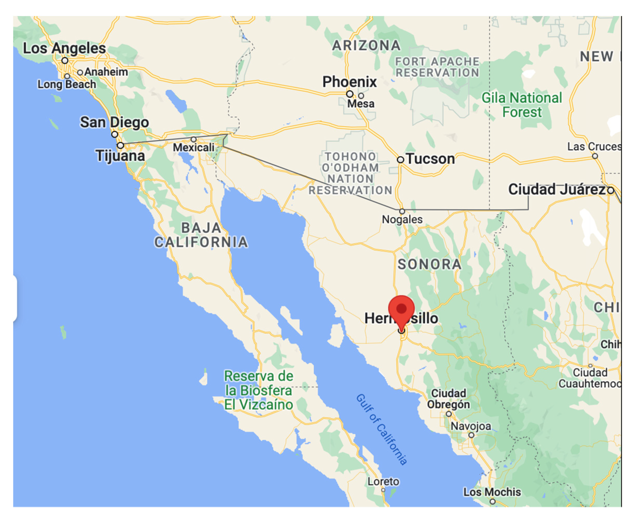
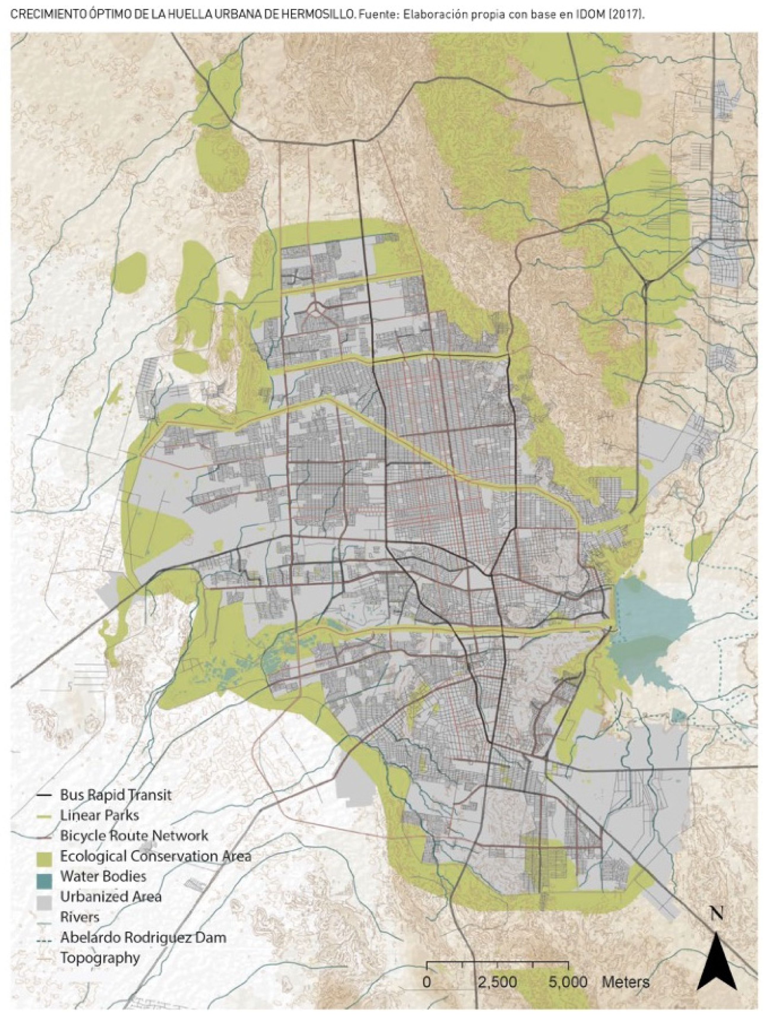
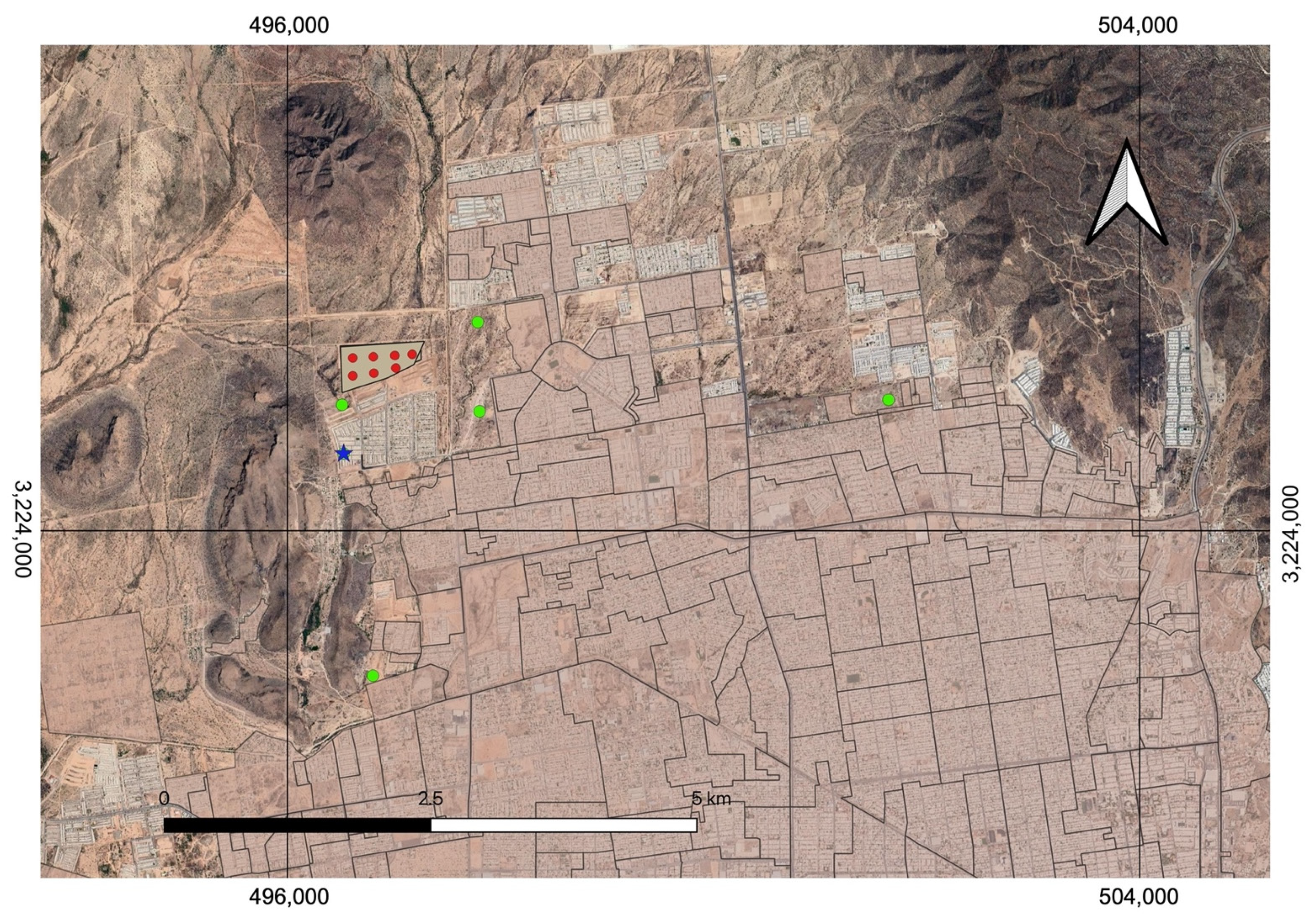
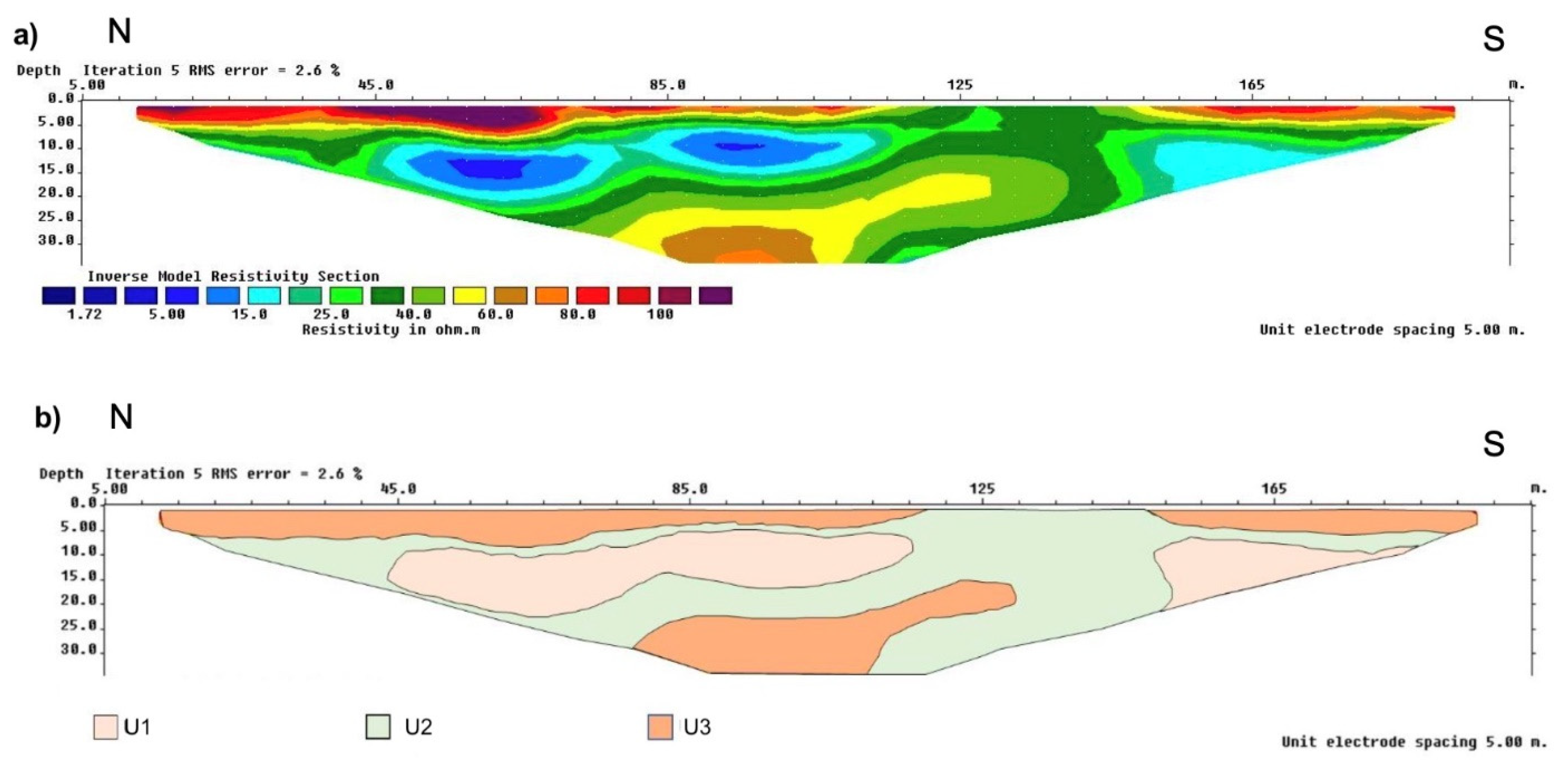
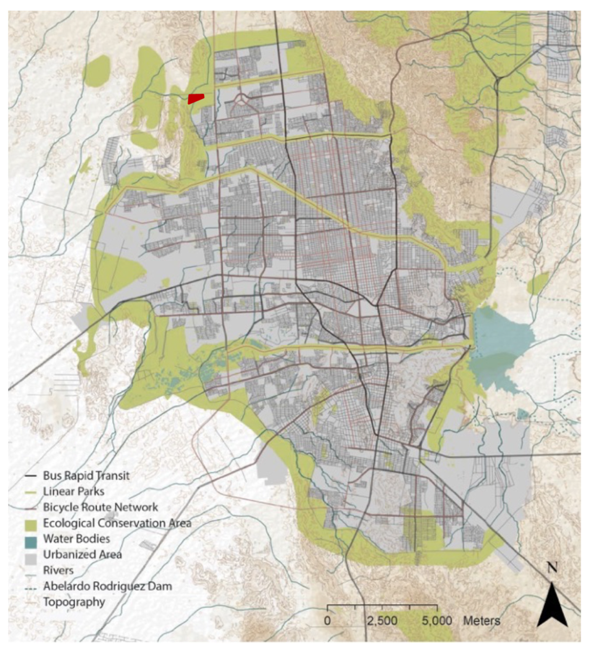
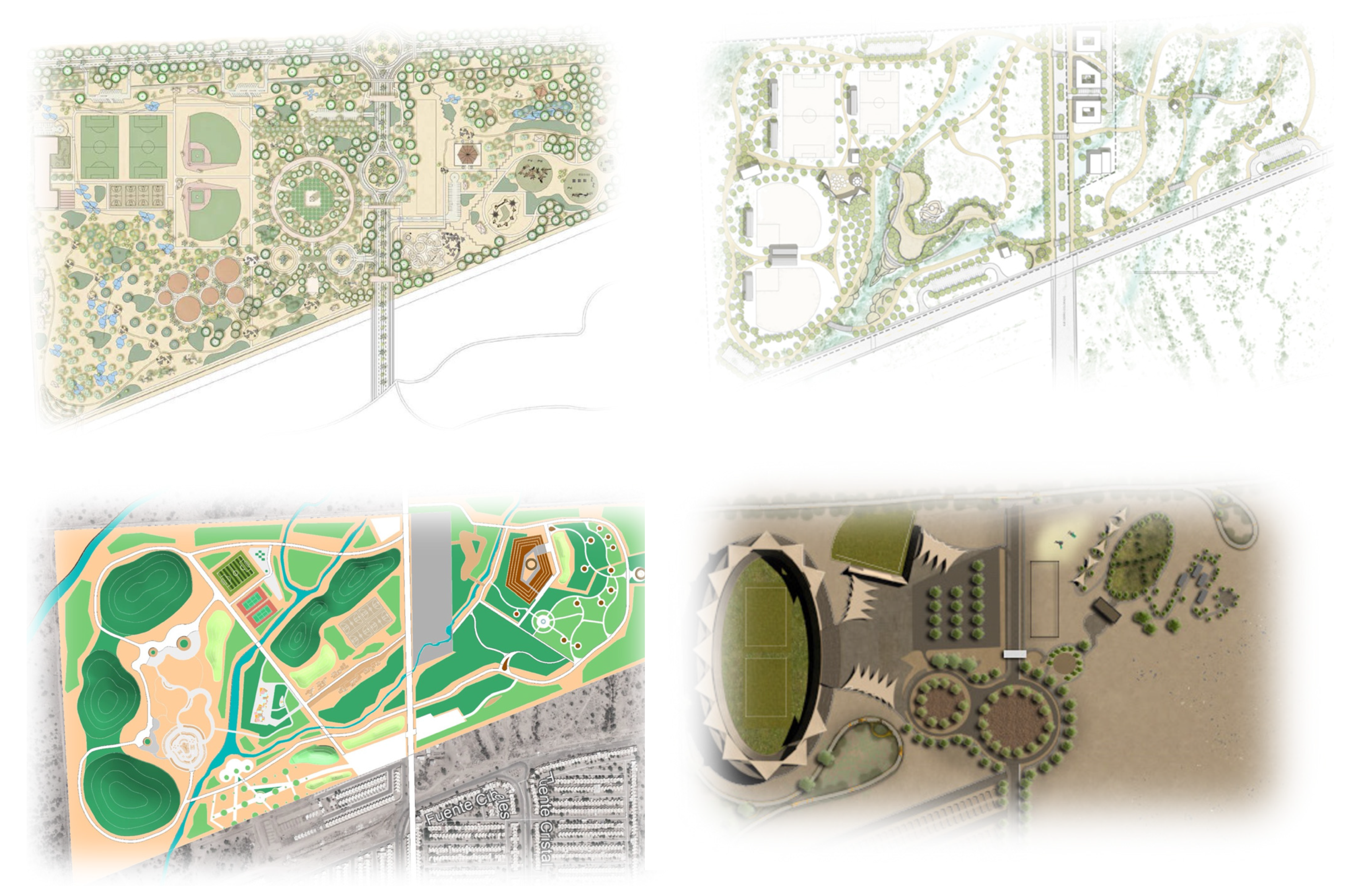
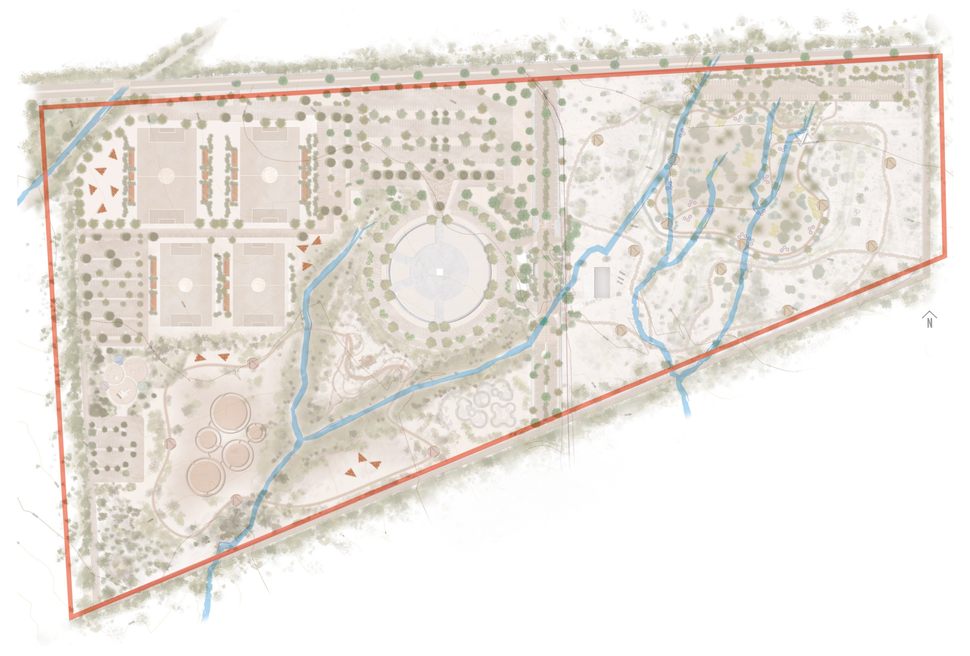
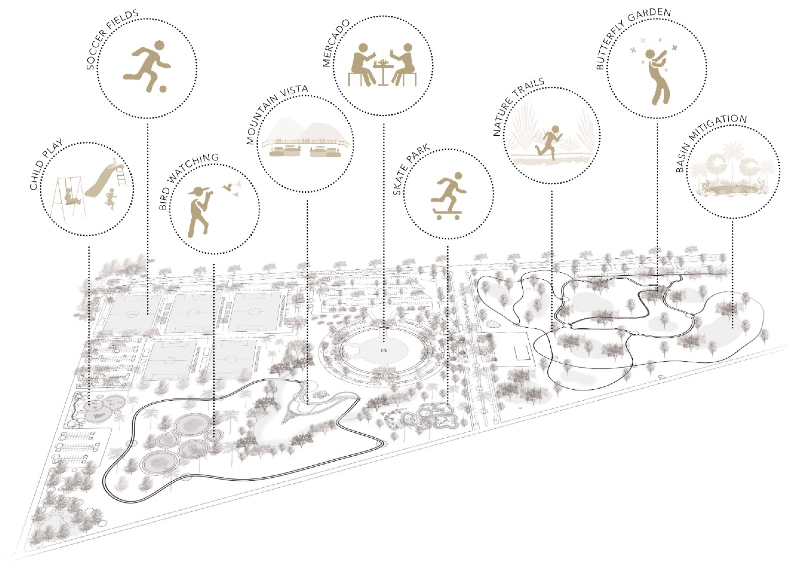
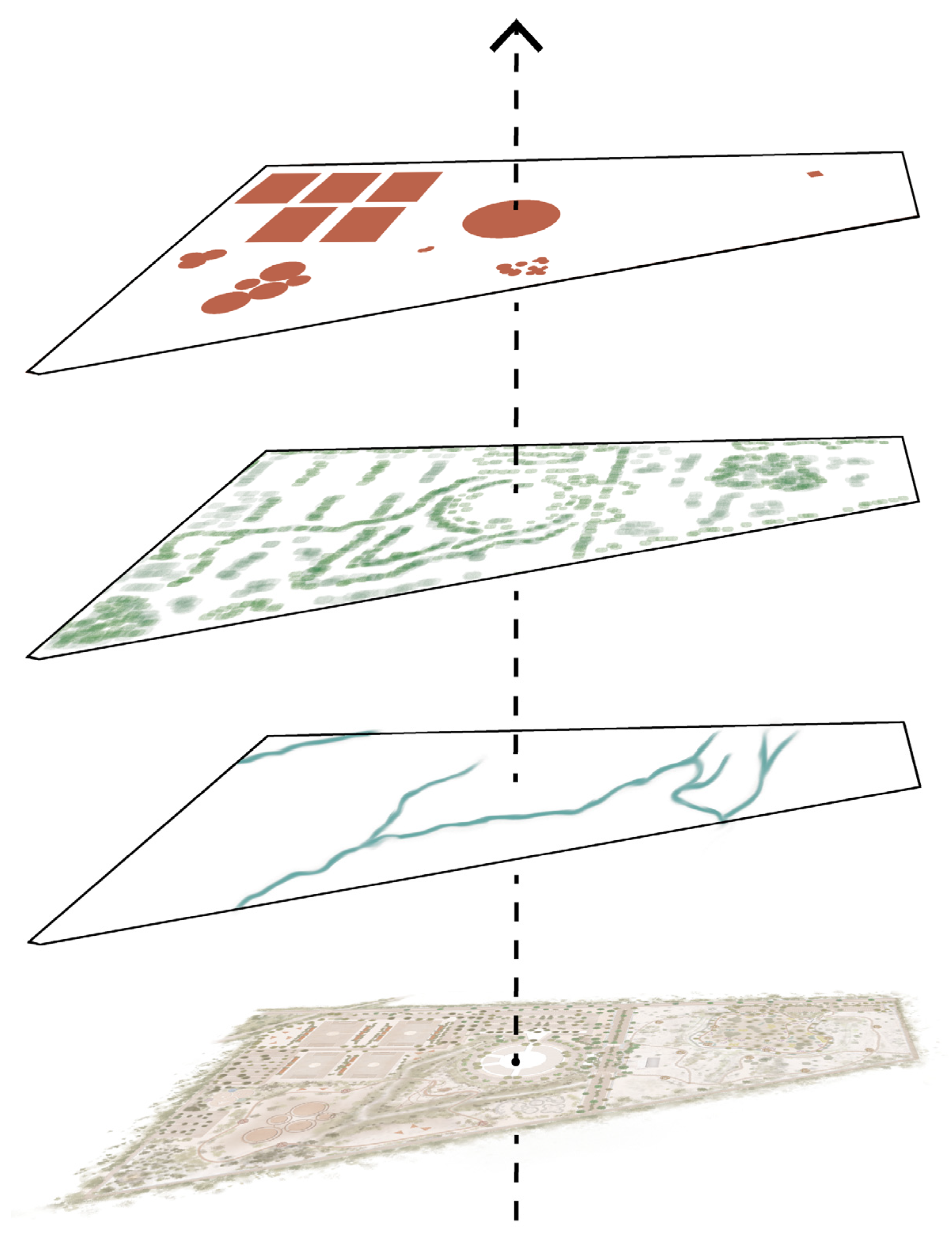
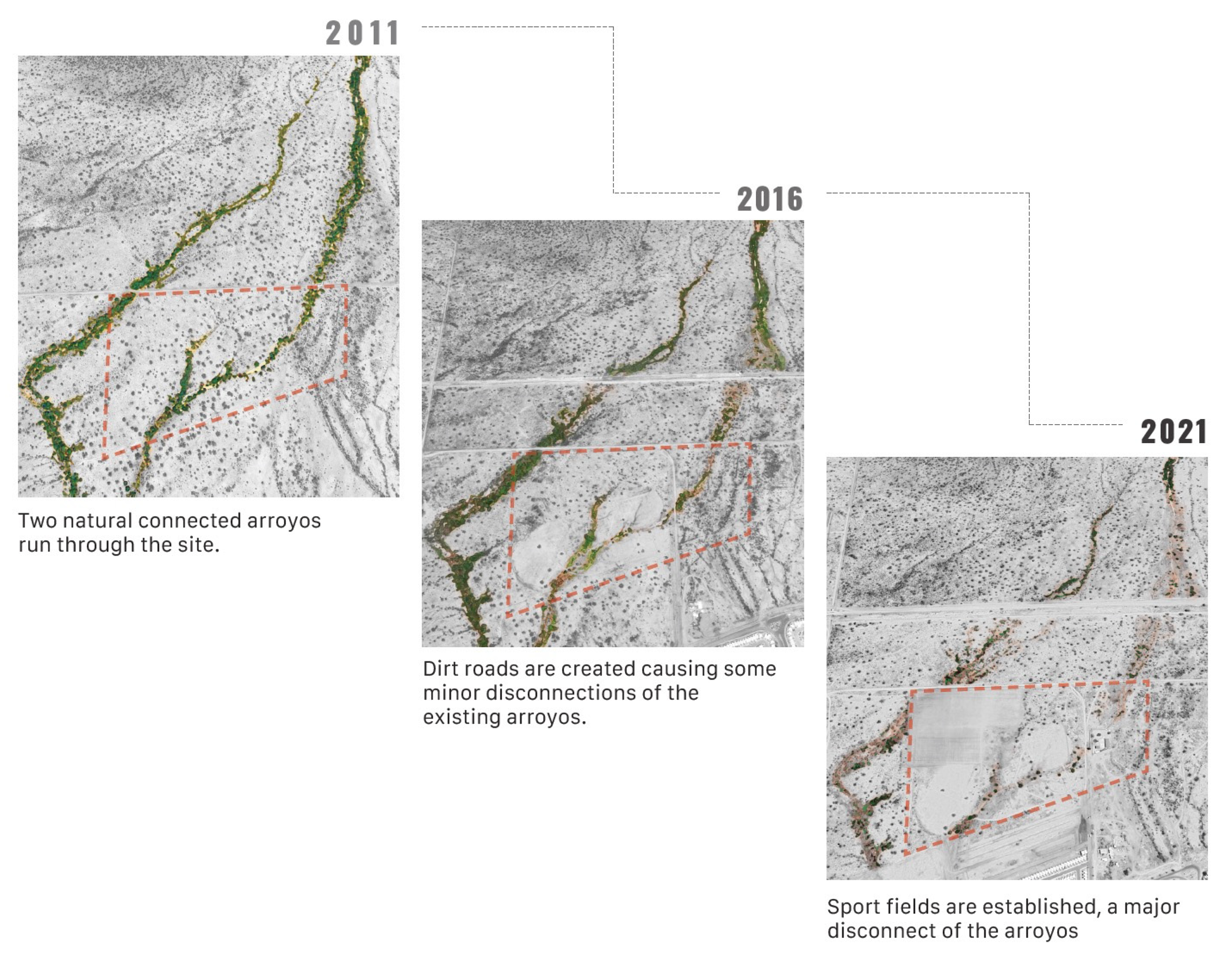
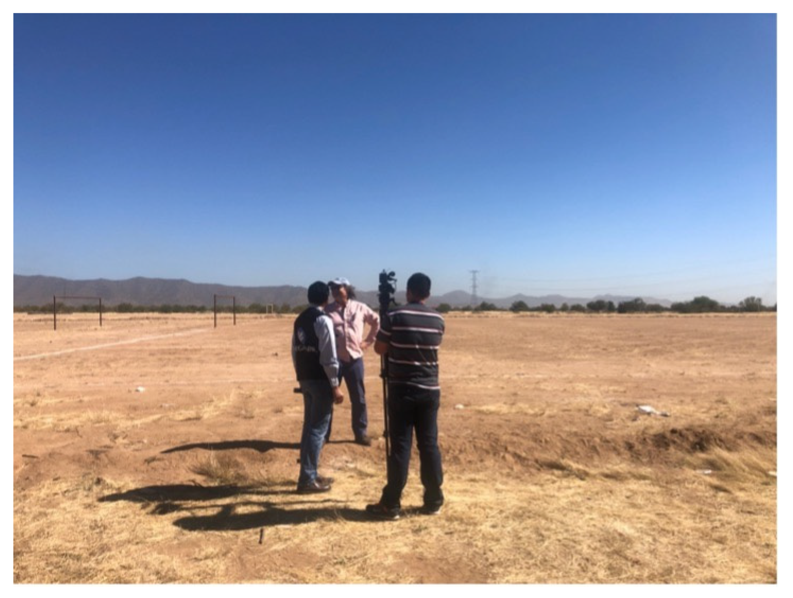
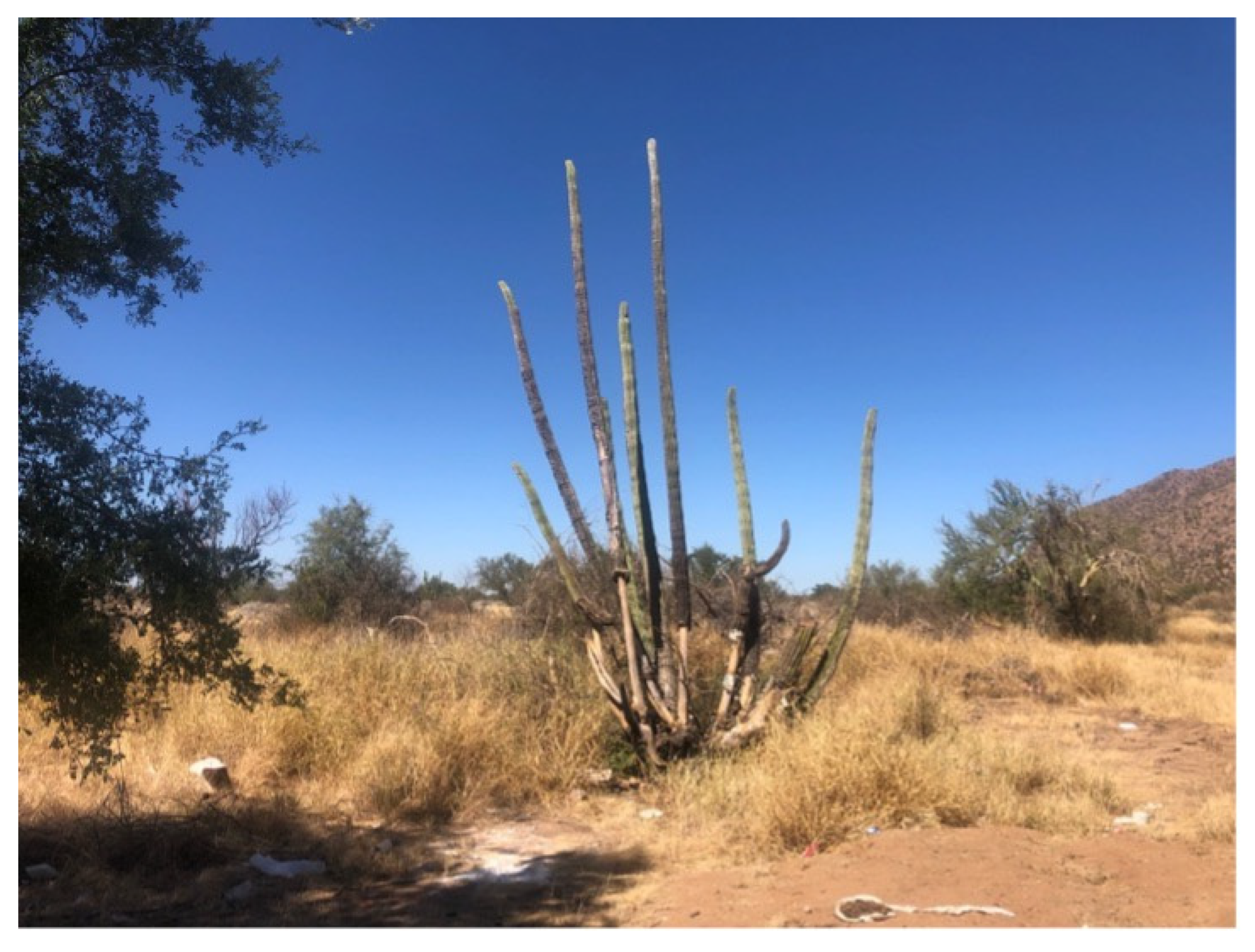
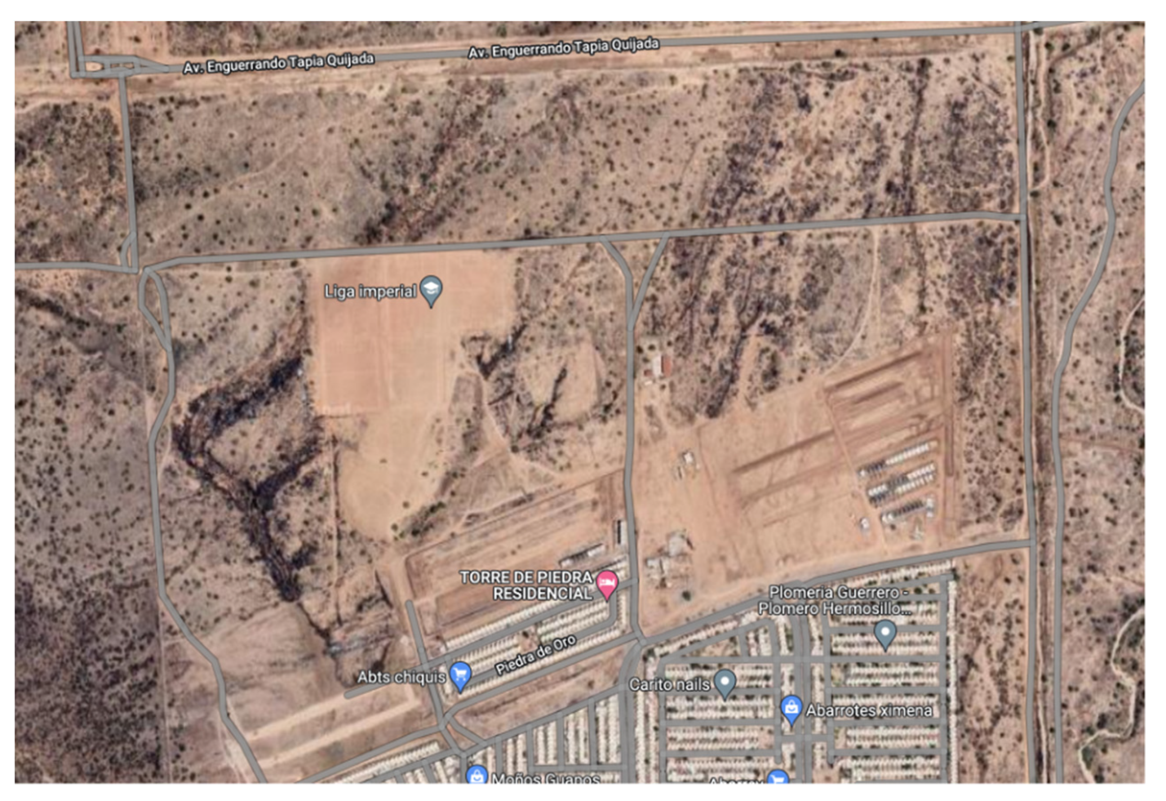