

Urbanscape, Land Use Change and Centralization in the Region of Uruk, Southern Mesopotamia from the 2nd to 1st Millennium BCE


Abstract
1. Introduction
2. Materials and Methods
2.1. Textual Description & Sources


2.2. Archaeological Survey
3. Results
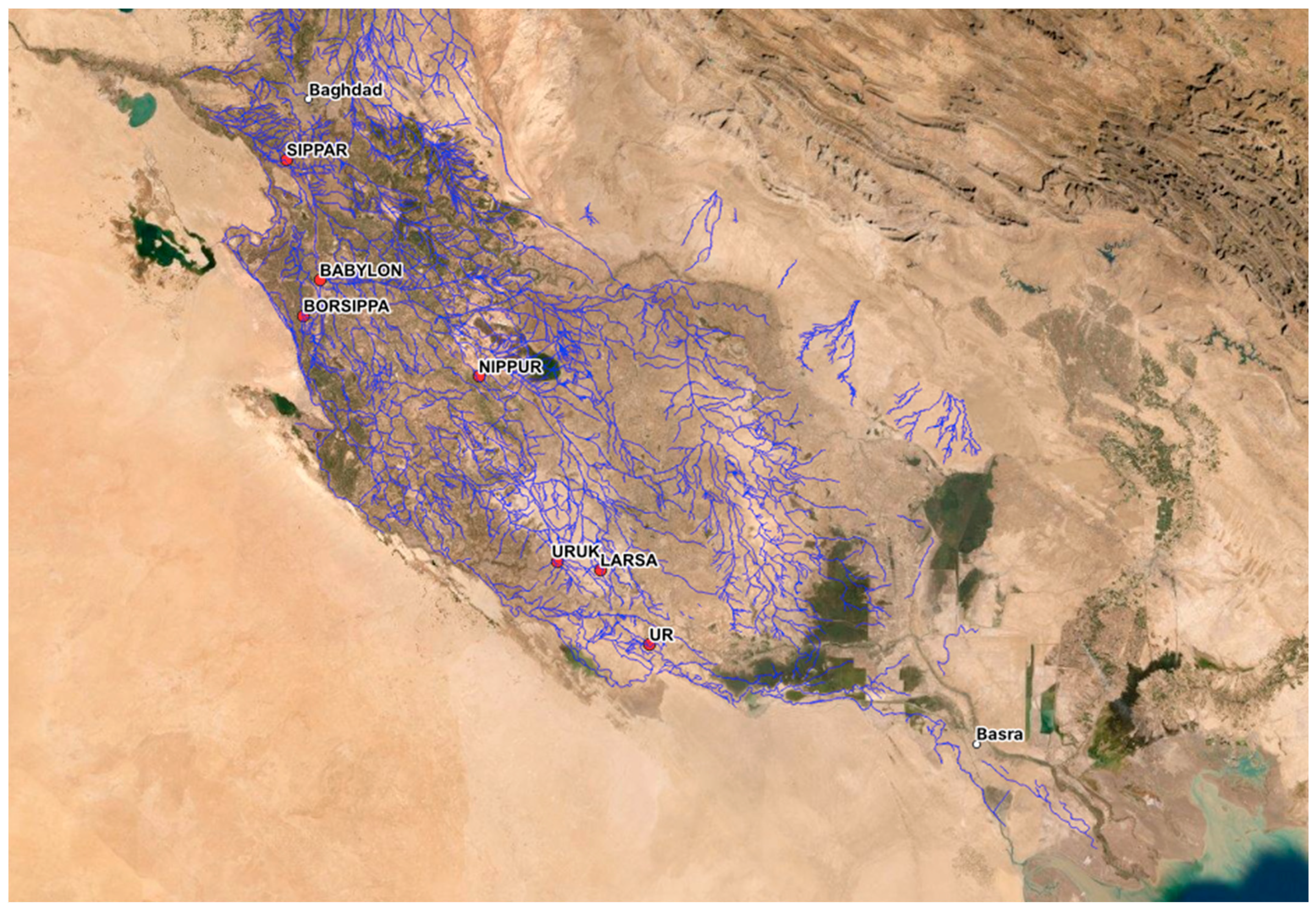
3.1. Geographical Context
3.1.1. Hydrological Site Biographies—Takkīru
3.1.2. Hydrological Site Biographies—Sumandar
3.1.3. Site Biographies—Fortified Settlements (Dūr-Places)
3.1.4. Site Biographies-Quays (Kār-Places)
3.2. The Archaeological Survey
4. Discussion
4.1. The Textual Survey
4.2. Synthesis with the Archaeological Survey
4.3. Discussion
“overseer of fifty (rab hanšê), who in the presence of Marduk-apla-iddina (II), king of Babylon, seized (each) 150 (cubits) of land on the bank of Harru-ša-Marduk-apla-iddina, from the boundary of Bīt-Zu-gunabu. 1100 (cubits) of the temple (equals) 1000 (cubits) of the king”[57] (p. 1*)
5. Conclusions
Future Focus
Supplementary Materials
Author Contributions
Funding
Data Availability Statement
Acknowledgments
Conflicts of Interest
| 1 | |
| 2 | Excavation in Mesopotamia began in earnest in the 19th century. Excavations of Uruk specifically began in the early 20th century, and have since been primarily conducted by the German Archaeological Institute. Notable surveys of canals are that of Jacobsen and Wilkinson. |
| 3 | |
| 4 | |
| 5 | Dates, especially in the 2nd Millennium BCE, are based on the Middle Chronology, see [25]. |
| 6 | This date refers to the historical period in general; Uruk is mentioned in Neo-Assyrian chronicles only from the mid-8th century BCE. |
| 7 | See the recent excavation (spring 2022) of the remains of an Urukean boat by the DAI and Iraqi State Antiquities Board: https://www.dainst.org/en/presse/pressemitteilung/-/article-display/L11mBpjClzu5/4845682 (accessed on 1 July 2022). |
| 8 | Kār-Sukkal, Kār-Sîn, Kār-Ninurta, Kār-Ninsianna, Kār-Ningirsu, and Kār-Nineanna. Determining the specific location of many individual places such as these is challenging, as they are often singularly mentioned in the textual record. |
| 9 | These data have been collected and digitized by the MAPA project [24]. |
| 10 | In addition to King the tablet E.S.9567 is cited, the storage details of which are recorded in [21] (p. XIV). |
| 11 | Place-names of this type are often only known by a logographic name, and a translation into Akkadian or phonetic spelling is unknown. These logograms are often associated with Sumerian, but the connection is not direct enough to assume the source of these place-names. |
| 12 | Zadok uses the German spelling Jakīn of these place-names. |
| 13 | Dalley [44] suggests it may date to the end of the Old Babylonian period. |
| 14 | |
| 15 | Which may refer to either a king or a god. |
| 16 | 2, 6, 7, 11, 26, 36, 38, 78, 79, 80, 81, and 91. |
| 17 | 12, 31, 35, 37, 49, 63, and 72. |
| 18 | 9, 17, 66, 73, and 90. |
| 19 | These results are collected in the supplementary data. |
| 20 | See Jursa [5] (p. 264) for explanations of this specific translation of šatammu. |
References
- Kose, A. Uruk: Architectur IV; Boehmer, R.M., Englund, K., Deutsches Archäologisches Institut, Eds.; AUWE-17; Philip von Zabern: Mainz am Rhein, Germany, 1988. [Google Scholar]
- Gehlken, E. Spatbabylonische Wirtschaftstexte aus dem Eanna-Archiv; AUWE-5; Philip von Zabern: Mainz am Rhein, Germany, 1990. [Google Scholar]
- Adams, R.M. Heartland of Cities: Surveys of Ancient Settlement and Land Use on the Central Floodplain of the Euphrates; University of Chicago Press: Chicago, IL, USA, 1981. [Google Scholar]
- Adams, R.M.; Nissen, H.J. The Uruk Countryside: The Natural Setting of Urban Societies; University of Chicago Press: Chicago, IL, USA, 1972; p. 241. [Google Scholar]
- Jursa, M.; Dietrich, M. Aspects of the Economic History of Babylonia in the First Millennium BC; Dietrich, M., Loretz, O., Neumann, H., Eds.; Ugarit Verlag: Münster, Germany, 2010. [Google Scholar]
- Janković, B. Aspects of Urukean Agriculture in the First Millennium BC. Ph.D. Thesis, University of Vienna, Vienna, Austria, 2013. [Google Scholar]
- Becker, H.; van Ess, M.; Fassbinder, J. Uruk: Urban Structures in Magnetic and Satellite Images. In Uruk: First City of the Ancient World; van Ess, M., Hilgert, M., Salje, B., Crüsemann, N., Eds.; Getty Publications: Los Angeles, CA, USA, 2019; pp. 335–341. [Google Scholar]
- Mittelmayer, C.; Uruk, A., IV. Philologisch. In Mythos Und Literatur. Reallexikon Assyriol. Vorderasiat. Archäologie 2016, 14, 455–457. [Google Scholar]
- Jacobsen, T. The Waters of Ur. Iraq 1960, 22, 174–185. [Google Scholar] [CrossRef]
- Wilkinson, T.J. Archaeological Landscapes of the Near East; University of Arizona Press: Tucson, AZ, USA, 2003. [Google Scholar]
- Beaulieu, P.-A. A History of Babylon, 2200 BC–AD 75; Wiley Blackwell: Medford, MA, USA, 2018. [Google Scholar]
- Postgate, J.N. Early Mesopotamia: Society and Economy at the Dawn of History; Paperback; Routledge: London, UK; New York, NY, USA, 1994. [Google Scholar]
- Baker, H.D.; Jursa, M. Approaching the Babylonian Economy, Proceedings of the START Project Symposium Held in Vienna, Austria, 1–3 July 2004; Baker, H.D., Jursa, M., Eds.; Ugarit-Verlag: Münster, Germany, 2005. [Google Scholar]
- Widell, M. The Administrative and Economic Ur III Texts from the City of Ur; Gorgias Press: Piscataway, NJ, USA, 2003. [Google Scholar]
- Zadok, R. New Documents about Uruk, Its Countryside and the Sealand. In Des Polytheismes aux Monotheismes: Melanges d’Assyriologie offerts a Marcel Sigrist; Zadok, R., Gabbay, U., Pérennès, J.J., Eds.; Peeters: Leuven, Belgium; Paris, France, 2020; pp. 491–534. [Google Scholar]
- Cocquerillat, D. Palmeraies et Cultures de l’Eanna d’Uruk (559–520); ADFU-8; Gebr. Mann Verlag: Berlin, Germany, 1968. [Google Scholar]
- Joannès, F. Textes Economiques de la Babylonie Récente; Etude des Textes de TBER, Cahier n. 6; Editions Recherche sur les civilisations: Paris, France, 1982. [Google Scholar]
- Frahm, E.; Jursa, M. Neo-Babylonian Letters and Contracts from the Eanna Archive; YOS 21; Yale University Press: New Haven, CT, USA, 2011. [Google Scholar]
- Charpin, D. Chroniques bibliographiques. 12. Archives paléo-babyloniennes: Les textes et le terrain. Rev. D’assyriologie D’archéologie Orient. 2009, 103, 131–148. [Google Scholar] [CrossRef]
- Groneberg, B. Die Orts-Und Gewässernamen Der Altbabylonischen Zeit; RGTC-3; Dr. Ludwig Reichert Verlag: Wiesbaden, Germany, 1980. [Google Scholar]
- Nashef, K. Die Orts-Und Gewässernamen Der Mittelbabylonischen Und Mittelassyrischen Zeit; RGTC-5; Reichert Verlag: Wiesbaden, Germany, 1982; p. 372. [Google Scholar]
- Bagg, A.M. Die Orts-Und Gewässernamen Der Neuassyrischen Zeit, Teil 3: Babylonien, Urartu Und Die Östlichen Gebiete; RGTC-7; Reichert Verlag: Wiesbaden, Germany, 2020; Volume 3. [Google Scholar]
- Zadok, R. Geographical Names According to New—and Late-Babylonian Texts; RGTC-8; Dr. Ludwig Reichert Verlag: Weisbaden, Germany, 1985; p. 427. [Google Scholar]
- Gordin, S.; Clark, S. Mesopotamian Ancient Place-Names Almanac Gazetteer, Ver. 1.0, 2022. Available online: https://zenodo.org/record/6411251#.Y2B0feRBxPY (accessed on 1 August 2022).
- Höflmeyer, F. Establishing an Absolute Chronology of the Middle Bronze Age. In Oxford History of the Ancient Near East; Radner, K., Potts, D.T., Moeller, N., Eds.; Oxford University Press: Oxford, UK, 2022; Volume 2. [Google Scholar]
- Radner, K.; Moeller, N.; Potts, D.T. (Eds.) Oxford History of the Ancient Near East; Oxford University Press: Oxford, UK, 2022; Volume 2. [Google Scholar]
- Algabri, A. Settlement Patterns in the West of Uruk during the Second Millennium BC. M.A.; University of Al-Qadisiyah: Al-Qadisiyah, Iraq, 2020. [Google Scholar]
- Morozova, G.S. A Review of Holocene Avulsions of the Tigris and Euphrates Rivers and Possible Effects on the Evolution of Civilizations in Lower Mesopotamia. Geoarchaeology 2005, 20, 401–423. [Google Scholar] [CrossRef]
- Jotheri, J.; Allen, M.B.; Wilkinson, T.J. Holocene Avulsions of the Euphrates River in the Najaf Area of Western Mesopotamia: Impacts on Human Settlement Patterns. Geoarchaeology 2016, 31, 175–193. [Google Scholar] [CrossRef]
- Wilkinson, T.J.; Wilkinson, E.B.; Ur, J.; Altaweel, M. Landscape and Settlement in the Neo-Assyrian Empire. Bull. Am. Sch. Orient. Res. 2005, 340, 23–55. [Google Scholar] [CrossRef]
- Ermidoro, S. New Data on the Babylonian Hydraulic Landscape: An Update to the Repertoire Geographique Des Textes Cuneiformes Vol. 8. KASKAL 2016, 13, 135–174. [Google Scholar]
- King, L.W. Babylonian Boundary Stones and Memorial Tablets in the British Museum. With an Atlas of Plates; Trustees of the British Museum: London, UK, 1912. [Google Scholar]
- Lutz, H.F. Selected Sumerian and Babylonian Texts; Publications of the Babylonian Section; University of Pennsylvania Press: Philadelphia, PA, USA, 1919; Volume 2. [Google Scholar]
- Paulus, S. Die Babylonischen Kudurru-InschriftenVon Der Kassitischen Bis Zur Frühneubabylonischen Zeit; Ugarit-Verlag: Münster, Germany, 2014. [Google Scholar]
- Tadmor, H. The Inscriptions of Tiglath-Pileser III; Israel Academy of Sciences and Humanities: Jerusalem, Israel, 1994. [Google Scholar]
- Scheil, V. Textes élamites-Sémitiques, Première Série; E. Leroux: Paris, France, 1900. [Google Scholar]
- Abraham, K. Kaštiliašu and the Sumundar Canal: A New Middle Babylonian Royal Inscription. Zeitschrift Assyriologie 2013, 103, 183–195. [Google Scholar] [CrossRef]
- Ungnad, A. Vorderasiatische Schriftdenkmäler Der Königlichen Museen Xu Berlin 8; Vorderasiatische Schriftdenkmäler der Staatlichen Museen zu Berlin; J.C. Hinrichs: Leipzig, Germany, 1909. [Google Scholar]
- Thureau-Dangin, F. Lettres et Contrats de L’Epoque de la Premiere Dynastie Babylonienne; Textes Cuneiformes des Louvre (TCL); Librarie Orientaliste Paul Geuthner: Paris, France, 1973. [Google Scholar]
- Arnaud, D. Quelques Nouvelles Brices Inscrites de Larsa. Rev. D’assyriologie D’archéologie Orient. 1972, 66, 163–176. [Google Scholar]
- Brinkman, J.A. Prelude to Empire: Babylonian Society and Politics, 747–626 B.C.; Occasional Publications of the Babylonian Fund; University Museum: Philadelphia, PA, USA, 1984. [Google Scholar]
- Hritz, C.; Al-Hawi, N.D.; Al-Sudani, K.J.; Albadran, B.N.; Pournelle, J. Resilient Landscapes: The Evolution of Riparian Landscape Studies in Southern Iraq. In New Agendas in Remote Sensing and Landscape Archaeology in the Near East. Studies in Honour of Tony J. Wilkinson; Lawrence, D., Ed.; Archaeopress: Oxford, UK, 2020; pp. 228–267. [Google Scholar]
- Fuchs, A. Die Inschriften Sargons II, Aus Khorsabad; Cuvillier Verlag: Gottingen, Germany, 1994. [Google Scholar]
- Dalley, S. The First Sealand Dynasty: Literacy, Economy, and the Likely Location of Dūr-Enlil(ē) in Southern Mesopotamia at the End of the Old Babylonian Period. In Babylonia under the Sealand and Kassite Dynasties; Paulus, S., Clayden, T., Eds.; De Gruyter: Berlin, Germany; Boston, MA, USA, 2020; pp. 9–27. [Google Scholar]
- Gordon, S.; Clark, S.; Romach, A. MAPA: A Linked Open Data Gazetteer of the Southern Babylonian Landscape. In Interdisciplinary Digital Engagement in Arts & Humanities; Forthcoming.
- Jason, U. Harvard WorldMap, 2022. Available online: https://worldmap.maps.arcgis.com/home/index.html (accessed on 28 October 2022).
- Hritz, C. Tracing Settlement Patterns and Channel Systems in Southern Mesopotamia Using Remote Sensing. J. Field Archaeol. 2010, 35, 184–203. [Google Scholar] [CrossRef]
- Hritz, C.; Wilkinson, T.J. Using Shuttle Radar Topography to Map Ancient Water Channels in Mesopotamia. Antiquity 2006, 80, 415–424. [Google Scholar] [CrossRef]
- Steinkeller, P. New Light on the Hydrology and Topography of Southern Babylonia in the Third Millennium. Zeitschrift Assyriologie Vorderasiastische Archaeologie 2001, 91, 22–84. [Google Scholar] [CrossRef]
- Yamada, S. Karus on the frontier of the Neo-Assyrian Empire. Orient 2005, 40, 56–90. [Google Scholar] [CrossRef]
- Frame, G. A “New” Cylinder Inscription of Sargon II of Assyrian from Melid. In Of God(s), Trees, Kings and Scholars: Neo-Assyrian and Related Studies in Honour of Simo Parpola; Studia Orientalia; Finnish Oriental Society: Helsinki, Finland, 2009; pp. 65–82. [Google Scholar]
- al-Hamdani, A. The Settlement and Canal Systems in Lower Southern Mesopotamia During the First Dynasty of the Sealand (1721–1340 BCE). In Babylonia under the Sealand and Kassite Dynasties; Paulus, S., Clayden, T., Eds.; De Gruyter: Berlin, Germany; Boston, MA, USA, 2020; pp. 28–57. [Google Scholar]
- Powell, M.A. Merodach-Baladan at Dur-Jakin: A Note on the Defense of Babylonian Cities. J. Cuneif. Stud. 1982, 34, 59–61. [Google Scholar] [CrossRef]
- Brinkman, J.A. Political History of Post-Kassite Babylonia 1158–722 B.C.; Analecta Orientalia; Pontificum Institutum Biblicum: Rome, Italy, 1968; p. 431. [Google Scholar]
- Keiser, C.E. Letters and Contracts from Erech Written in the Neo-Babylonian Period; Babylonian Inscriptions in the Collection of James B. Nies; Yale University Press: New Haven, CT, USA, 1918. [Google Scholar]
- Levavi, Y. Administrative Epistolography in the Formative Phase of the Neo-Babylonian Empire; Zaphon: Münster, Germany, 2018. [Google Scholar]
- Pohl, P.A. Neubabylonische Rechtsurkunden aus der Berliner Staatlichen Museen; Analecta Orientalia; Pontificio Instituto Biblico: Rome, Italy, 1934; Volume 2. [Google Scholar]
- Ephʻal, I. The Ancient Arabs: Nomads on the Borders of the Fertile Crescent, 9th–5th Century B.C.; Magnes Press; Brill: Jerusalem, Israel; Leiden, The Netherlands, 1982. [Google Scholar]


Publisher’s Note: MDPI stays neutral with regard to jurisdictional claims in published maps and institutional affiliations. |
© 2022 by the authors. Licensee MDPI, Basel, Switzerland. This article is an open access article distributed under the terms and conditions of the Creative Commons Attribution (CC BY) license (https://creativecommons.org/licenses/by/4.0/).
Share and Cite
Clark, S.; Altaweel, M.; Gordin, S. Urbanscape, Land Use Change and Centralization in the Region of Uruk, Southern Mesopotamia from the 2nd to 1st Millennium BCE. Land 2022, 11, 1955. https://doi.org/10.3390/land11111955
Clark S, Altaweel M, Gordin S. Urbanscape, Land Use Change and Centralization in the Region of Uruk, Southern Mesopotamia from the 2nd to 1st Millennium BCE. Land. 2022; 11(11):1955. https://doi.org/10.3390/land11111955
Chicago/Turabian StyleClark, Shmuel, Mark Altaweel, and Shai Gordin. 2022. "Urbanscape, Land Use Change and Centralization in the Region of Uruk, Southern Mesopotamia from the 2nd to 1st Millennium BCE" Land 11, no. 11: 1955. https://doi.org/10.3390/land11111955
APA StyleClark, S., Altaweel, M., & Gordin, S. (2022). Urbanscape, Land Use Change and Centralization in the Region of Uruk, Southern Mesopotamia from the 2nd to 1st Millennium BCE. Land, 11(11), 1955. https://doi.org/10.3390/land11111955