1. Introduction
In relation to agriculture, big data is understood as the combination of technology and advanced analytics to process information in a way that is more useful and timely than traditional methods [
1]. This definition applies equally to agricultural enterprise decisions (agronomical, financial or otherwise) as well as to agricultural research. The trend to leverage big data in agriculture is evidenced by the increasingly intense incorporation of data generating, storing, processing and analysis into the business models of industries that have traditionally served the agricultural sector with conventional agricultural equipment and inputs. In the context of the depleting Mississippi River Valley Alluvial Aquifer (MRVAA), big data has an important role in ensuring that irrigation decisions are made such that the allocation of the groundwater stocks are the most beneficial and valuable across uses and over time. The National Center for Alluvial Aquifer Research (NCAAR) is uniquely positioned to exploit big data in agricultural research that, through technology transfer, can be translated into decision tools for farmers and to further expand the range of technologies and information that are applicable at the farm level. The ultimate goal is to exploit big data to successfully characterize the dynamics of biophysical and agricultural processes that can ensure the long-term sustainability of groundwater resources and farm-level economies.
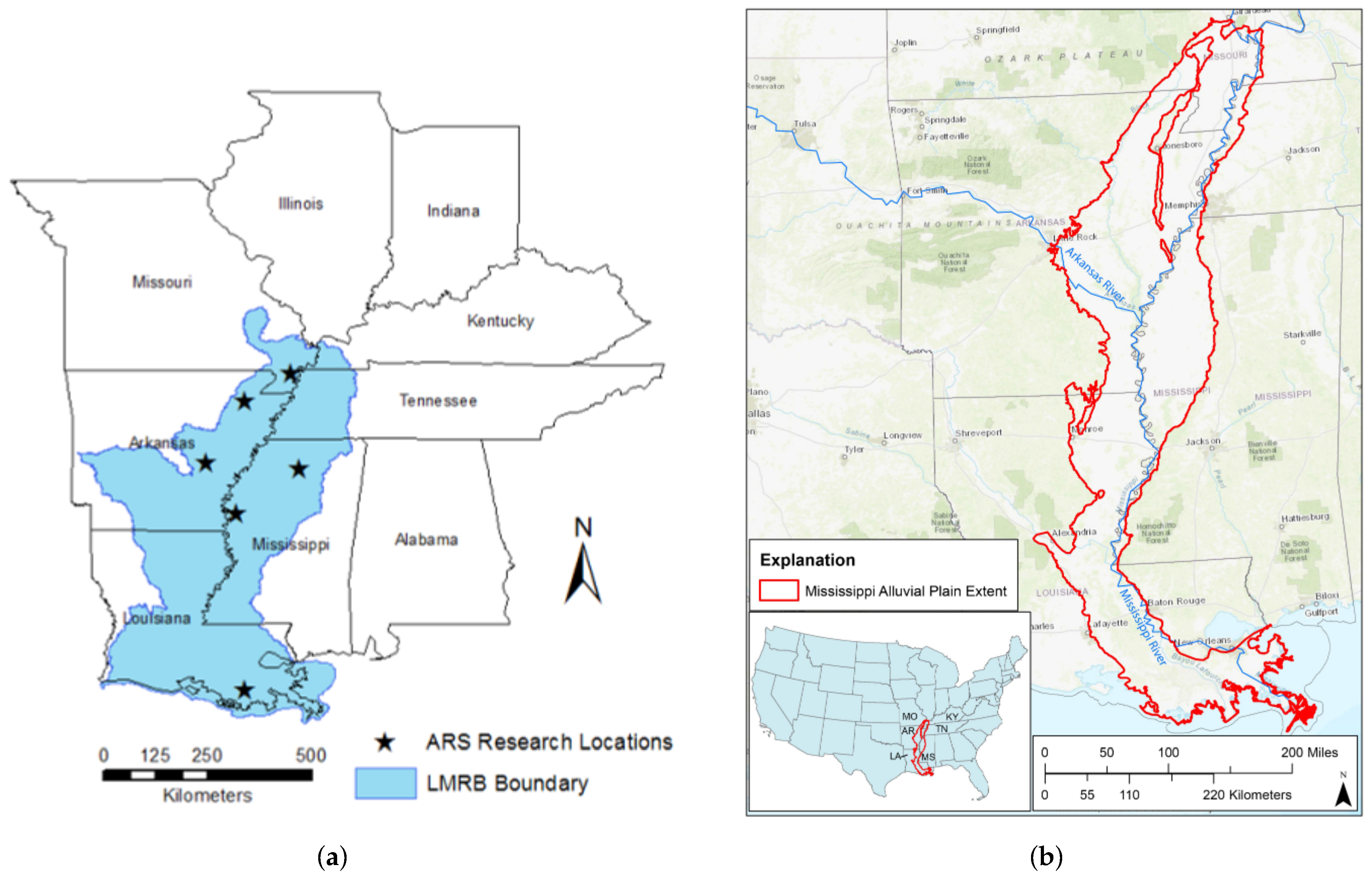
The Lower Mississippi River Basin (LMRB) (
Figure 1) receives an annual average rainfall of about 1143 mm (45 inches) in the north to about 1524 mm (60 inches) in the south region [
2]. However, only about
of the precipitation typically occurs when crops require large quantities of water to grow. Furthermore, the precipitation patterns in summer frequently include heavy rainfall events that cause runoff from cropland, with only a small amount of rainfall percolating into the soil profile and becoming available for plant use. Flash droughts can be detrimental to crop production in this area due to shallow root zones caused by tillage pans and soils’ low water holding capacity [
3]. Because of this variability in rainfall distribution within a year, farmers in the LMRB rely heavily on irrigation to meet crop water needs and obtain optimal crop yields while reducing the risk of flash droughts during the summer season [
3]. The primary source of water for irrigation in this region is groundwater pumped from the MRVAA. In terms of irrigation withdrawals, the MRVAA is the second most-utilized aquifer in the US. The MRVAA is the most utilized aquifer in the U.S. in terms of international virtual water transfer [
4]. The MRVAA is a sand and gravel aquifer overlain in most parts by a confining clay layer [
5,
6]. Recharge to the aquifer from surface water and precipitation is limited because of this confining layer, leading to recharge occurring mainly where the layer is not present or where large rivers have incised the confining layer [
5,
7]. The use of groundwater exceeding the rate of recharge has led to reduced levels of the MRVAA [
8,
9]. Ongoing depletion and stagnant recharging of the aquifer jeopardize the aquifer’s long-term availability and place irrigated agriculture in the aquifer’s region on an unsustainable path.
Agriculture is a large consumer of water resources and has been targeted as a significant contributor to water quality degradation across various regions of the United States [
10]. Intensive agricultural practices and erodible soils have led to high concentrations of sediment and nutrients in regional water bodies and eutrophication across the Delta. The region also contributes nutrient loads to the Gulf of Mexico, where a hypoxic zone has created an environmental and economic problem of national importance [
11]. It is necessary to seek improved irrigation methods and scheduling, alternative water use, crop management, and field practices to increase water use efficiency, reduce groundwater withdrawal for irrigation, increase the aquifer recharge, and protect water quality for sustainable water use of the MRVAA. All of these goals will require the use of new technology and big data resources.
To address the increasing concern over the MRVAA, USDA was directed by the United States Congress to form a joint research unit between United States Department of Agriculture’s (USDA) Agriculture Research Service (ARS) and Mississippi State University’s (MSU) Mississippi Agricultural and Forestry Experiment Station. From this legislation, NCAAR was formed in 2017. Based in Stoneville, MS, NCAAR is dedicated to conduct research and provide information for issues surrounding water use for agriculture and natural resources in the LMRB. Collaborations include researchers from MSU, several USDA-ARS research units, the University of Mississippi, the University of Arkansas, Arkansas State University, Kansas State University, Louisiana State University, University of Texas, and Alcorn State University.
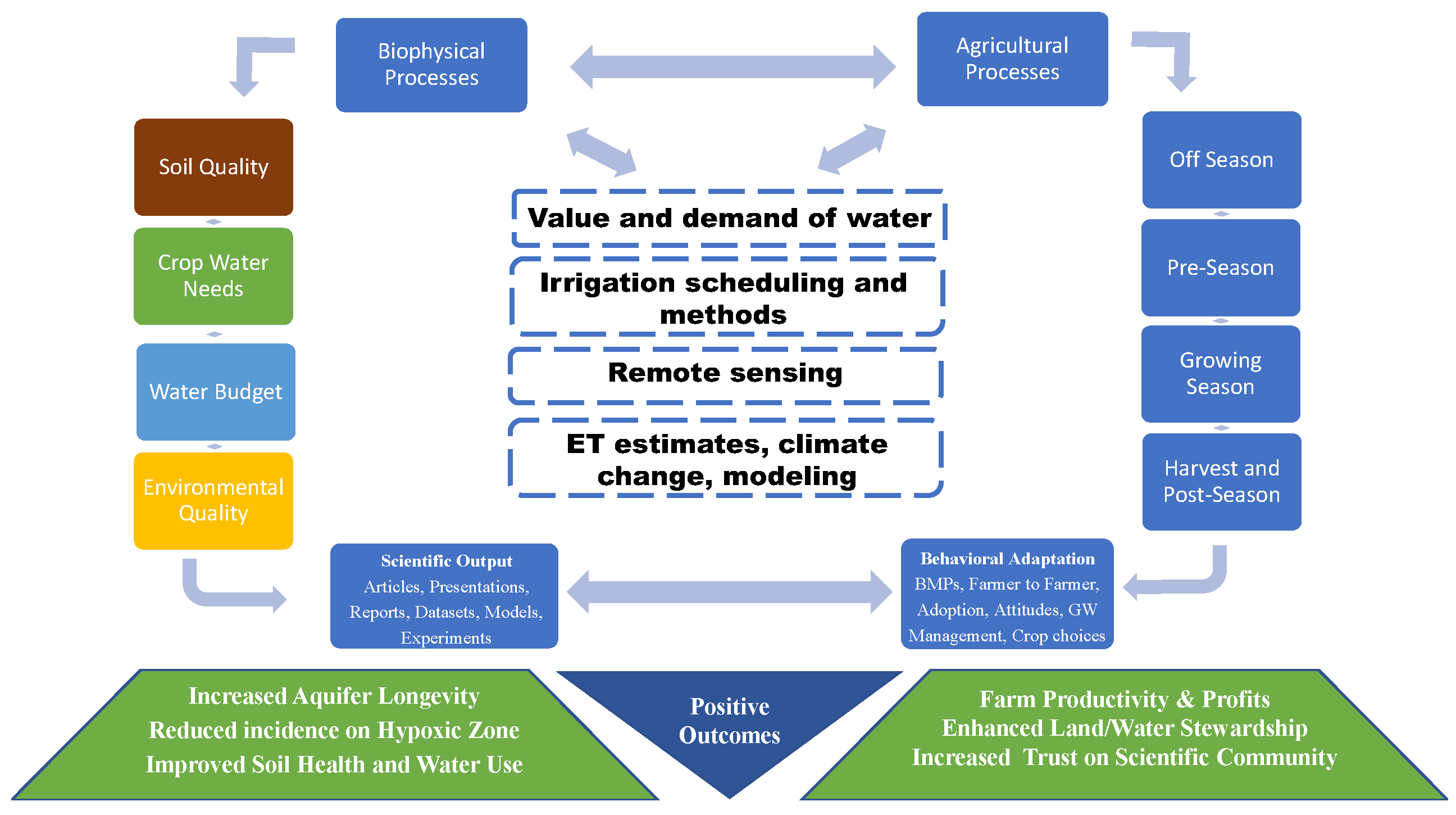
NCAAR aims to develop novel irrigation and water management technologies to improve water productivity, decrease irrigation water withdrawal, and increase the groundwater recharge to the MRVAA to maintain sustainable agricultural water supplies in the LMRB. To achieve this goal, the following objectives are being undertaken: (1) developing robust datasets, models, and data visualization tools to determine the impact of alternate water supplies on aquifer recharge, groundwater levels, and water quality in the LMRB, including effectiveness of current best management practices (BMPs), (2) developing optimized irrigation scheduling tools and new and novel sensor systems for cropping systems in the LMRB that account for crop water requirements, impacts of water stress, and economic and environmental sustainability while minimizing groundwater withdrawal from the aquifer, (3) integrating the new information into with decision support models and tools for prescription irrigation and water resource management, (4) engaging LMRB stakeholders through MSU Research and Extension partners to characterize producer behavior and attitudes with respect to irrigation and water conservation management, and introducing them to cutting edge digital tools, technologies, and best management practices for their particular situations (
Figure 2).
2. The Value and Demand for Water in Agricultural Uses
While the value of most commodities at any given time can be inferred from it’s market price; water for agricultural uses is a non-traded commodity in the LMRB. Consequently, the value of water in agriculture is usually determined by the monetary value of the goods and services it provides [
12]. Producers benefit directly from plentiful and inexpensive access to groundwater, which they convert into increased crop productivity, which contribute to keeping food abundant and relatively inexpensive for society at large. In other words, the value of the goods and services produced with groundwater from the MRVAA is only a fraction of the producer and consumer welfare derived from it. Nonetheless, it is useful to track and account for these derived welfares across space and among users to assess the most economically efficient allocation over time aimed at understanding and projecting overall water use together with the implications of pumping decisions on MRVAA.
The most relevant decisions are related to land use such as cropping decisions and irrigation management such as the preferred irrigation strategies and application technologies employed. A gap in knowledge exists in the LMRB with respect to the baseline status of land uses, irrigation technologies and the associated water use. In Mississippi, the Mississippi Department of Environmental Quality (MDEQ) Office of Land and Water Resources (OLWR) regulates water quantity issues affecting the beneficial use of these resources in the best interest and welfare of the citizens of the state (
https://www.mdeq.ms.gov, accessed on 1 September 2022) including a voluntary groundwater use reporting system which currently has a goal of obtaining flowmeter reading reports on approximately 10 percent of all permitted wells every year.
The reported water use must then be linked to land use, irrigation practices and technologies employed, the weather, and growing conditions that may have influenced a given report. The nature of the data relating water and land use is rather complicated. The nature of water management for irrigation and the evolution of crop field management subsequent to the permitting process produce a mismatch between permitted land and reported water use. The challenge of matching individual irrigation water use reports to the actual recipient fields and crops is difficult. A given field permitted to be irrigated by a given well may also be permitted to be irrigated by other wells. Only some wells report water use which means that imputation or aggregation algorithms are necessary to accomplish the task of assessing agricultural water use in the region. Over time, some wells may stop supplying water to fields originally covered by that well’s permit. Consequently, geospatial and econometric analyses based solely on reported water use assuming direct allocation to the permitted field may yield biased estimates of actual groundwater use and the effectiveness of various irrigation practices in conserving groundwater given other field and season characteristics. This highlights the opportunity to employ remote sensing, artificial intelligence and big data to alleviate the large measurement errors that can be expected given the current data generating processes.
The economic losses that arise from aquifer depletion are not immediately evident to producers [
13,
14]. This is particularly true in areas of the LMRB where groundwater is relatively abundant and the economic cost of temporal misallocation of groundwater is only evidenced by simulating and comparing alternative scenarios. Temporal misallocation occurs when relatively less valuable use in the present reduces the ability to irrigate in the future when production is more needed such as due to severe or frequent droughts caused by climate change, for example [
13,
15,
16]. The problem of preserving the MRVAA is essentially one of economic dynamics at its core and it involves determining the most beneficial groundwater extraction paths over time. As conditions for crop growing vary from season to season, so should the economically optimal groundwater extraction levels. In this context, a special challenge is to develop measures that enhance the resilience of irrigated agriculture in the face of water shortages or unreliability, particularly to reduce the associated economic losses [
17].
2.1. Water Value
As a non-traded commodity, the use value of water needs to be assessed by synthetic means including model simulations for different uses and over time. However, the use value is not the only important factor in water management. For instance, its use in crop production may be part of greater overarching interests. As valuable as water is in increasing agricultural production and to the farmers and their community, there is a societal interest in maintaining low food costs. Hence, the value of agricultural water is important in terms of the agricultural rents, but reallocating it to a higher value use may not be advisable because of food cost ripple effects. Consequently, estimates of the use value of groundwater do inform policy makers in managing and allocating this resource, as well as with respect to investments in water capture and recycling infrastructure that can increase the use and stock value of groundwater while supporting low-cost food. Recent estimates indicate that the availability of underlying groundwater has a significant influence on the value of agricultural land, up to
per megaliter (
per acre-ft) [
18]. The efficient temporal conjunctive management of groundwater and on-farm water storage can capitalize land in excess of
per ha (
per acre) in Sunflower County, MS [
13].
2.2. Irrigation Water Demand
The demand for groundwater affects the use value of the MRVAA as well as its rate of depletion. A good field-level characterization of the demand for groundwater is needed to adequately estimate the effects of policies and innovative agricultural practices on groundwater use and aquifer depletion. Most existing studies on conservation practices present the water savings achieved in experimental settings and project the basin-wide potential water savings achievable from adoption of the practice under study. However, farmer adoption has been slow [
19,
20] and the only MRVAA region estimate of producer demand for groundwater indicates that new practices and higher prices or taxes have little bearing on overall groundwater use [
21]. Field-level characterizations are needed because water conditions depend critically on supply and demand considerations. Both show great spatial variation that results in water problems that are localized in nature [
12,
22].
Within the Mississippi Delta, row crop production methods are relatively uniform. All counties in the region use the alluvial aquifer as an irrigation water source under the Yazoo Mississippi Delta Joint Water Management District (YMD), but regional differences exist. For example, eastern Sunflower County faces a water supply problem with an acutely depressed aquifer underneath it which calls for water capture or a recycling solution such as a tailwater recovery system, while western Bolivar County faces excess demand, despite the less depressed aquifer underneath which may call for improved irrigation efficiency solution. Southern Delta counties face the greatest threats due to flooding, and drainage solutions may be the most needed. For these reasons, the estimates must also be periodically updated to reflect changing conditions. Consequently, preliminary reports and articles derived from this line of research are expected to be consumed by regulatory and conservation agencies as well as producers and the broader scientific community. The estimates and projections should be an important input, for example, for the engineers in Managed Aquifer Recharge (MAR) projects. Good estimates of demands for groundwater will lead to more precise projections of groundwater use, better MAR designs, more efficient conservation practices, and more effective water conservation policies.
3. Irrigation Methods and Scheduling
Irrigation increased significantly in the LMRB in the last two decades. Total irrigated acreage was 3.4 million ha (8.4 million acres) in Arkansas, Louisiana, Mississippi, and Missouri in 2018, which increased compared to 2003. There are several irrigation applications and many factors go into to making irrigation decisions.
3.1. Furrow Irrigation
Furrow irrigation is the most common irrigation application method in the LMRB. This conventional delivery system for irrigation has an irrigation application efficiency of only up to
[
23]. The trends in depletion of the MRVAA can be reversed by implementing irrigation methods and technologies with better water application efficiencies [
24]. Multiple technologies that are already available to the farmers in this region include computer-hole-selection (PHAUCET: Pipe Hole and Universal Crown Elevation Tool or Pipe Planner), surge valves for increasing furrow irrigation application efficiency, tailwater recovery systems and/or drainage recycling for reuse of runoff, sprinkler irrigation systems for increasing irrigation application efficiency, and soil moisture sensors for increasing irrigation water-use efficiency by improving the decision-making abilities of producers when determining when to irrigate [
25,
26]. Irrigation application efficiency can be increased using sprinkler irrigation systems such as center pivot or linear lateral irrigation systems compared to furrow irrigation methods [
27,
28]. It is necessary to evaluate different irrigation methods with water conservation practices that can be best suited for diverse soil types in the LMRB, increase water use efficiency, and minimize aquifer withdrawal.
3.2. Sensor-Based Irrigation Scheduling
Soil water sensors, such as time-domain reflectometry devices and capacitive and resistive sensors have been developed and are widely adopted for soil moisture measurement in irrigation scheduling [
29,
30,
31,
32]. Previous research indicated that these sensors were inexpensive, easy to install and maintain, and provided useful information for irrigation scheduling. Multiple soil moisture sensors are usually installed at various soil depths across the root zone to measure the soil water content at each soil depth where each sensor reports one measurement at its respective depth. Interpreting the sensor measurements at each depth across the root zone has become an issue in application for irrigation scheduling. Crop root distribution across the root zone and the crop’s sensitivity to water stress varies with crop growth stages. Therefore, the algorithms/models for sensor-based irrigation scheduling should include the sensor-measured soil moisture at various depths, as well as other input parameters including crop root distributions and crop growth stages for improved performance and to give greater information on the actual moisture environment the crop is experiencing [
33]. This requires a large amount of data input and processing in real time.
3.3. Variable Rate Irrigation
Although furrow irrigation is still the primary irrigation method used in this region, more growers recognize that the MRVAA is on an unsustainable path and center-pivot irrigation is less labor-intensive and more efficient than furrow irrigation. Variable rate irrigation (VRI) technologies are capable of delivering desired amounts of water to specific locations in the irrigated area, which allows farmers to address the temporal and spatial variability of the soil and plants within a field [
34,
35]. Much research has been done on the use of sensors and global positioning systems to collect information on soil and plant conditions for VRI, which includes using electrical conductivity sensors to map soil apparent electrical conductivity [
36,
37], soil moisture sensors to measure soil water content or soil water potential [
31,
38], thermal irradiation sensors to detect plant canopy temperature [
35,
39], spectral reflectance and ultrasonic sensors to predict plant health characteristics [
40,
41], and mass-flow sensors to map crop yields [
42]. Soil physical properties in the LMRB can vary significantly within a single field [
43,
44]. The variability in soil properties results in different water storage capabilities and different amounts of water available to the crop, contributing to spatial variability of crop growth and creating challenges in crop water management. Soil electrical conductivity is related to soil properties and crop yield potential [
37,
45], and can be used to delineate site-specific management zones for VRI [
46].
In the early stages of VRI innovation, most VRI studies focused on the development of hardware and software systems to deliver a certain amount of water to each management zone [
34,
47]. In recent years, more studies have been done on developing VRI algorithms and management zones to optimize water use efficiency and farming profits [
46,
48]. Although sprinkler irrigation systems equipped with VRI controllers are commercially available, effective methods to create VRI prescriptions using information from various sensors and acquiring evidence to prove the advantages of VRI have become a bottleneck in the development and adoption of VRI technologies.
3.4. Surface Irrigation Automation
About four-fifths of irrigated cropland in the LMRB receive surface irrigation [
49]. Innovations and testing of automation for surface irrigation have been occurring for decades. Haise and Whitney [
50] developed hydraulic ditch gates that responded to in-field soil moisture sensors more than a half-century ago. Haise and Kruse [
51] designed pneumatic valves that cut off irrigation based on a timer and hydraulic ditch gates that cut off irrigation based on a rising float near the bottom end of an alfalfa field. Fischbach et al. [
52] integrated tailwater recovery into their automated system. Since the pioneering work in the 1960s, many variations have been proposed to automate the conclusion of a surface irrigation application either at a pre-programmed time or upon direct sensor feedback, including from ground [
53] and aerial imagery [
54]. Most notably, a commercial version that implements user-selected irrigation durations has been operated by Australian farmers to achieve application efficiencies above
[
55]. More complex approaches to surface irrigation automation often involve real-time optimization. Infiltration dynamics are characterized on the go by assimilating simple measurements (e.g., advance, runoff) into volume balance calculations [
56,
57]. Interest in real-time optimization was initially sparked by the desire to add cutback functionality [
58,
59], allowing for the reduction of flow after the initial wetting of the soil. Other researchers incorporated real-time optimization into non-cutback automation with the goal of satisfying hydrological criteria rather than following arbitrary on-off rules [
60,
61]. Overall, the success of surface irrigation automation suggests that this technology would be a valuable and practical part of the water conservation “toolbox” in the LMRB. As industry lowers the cost hurdle of automation [
62], the on-farm adoption rate of automation is expected to increase [
63].
3.5. Deficit Irrigation
In a limited irrigation strategy (deficit irrigation), differential responses of crops to water stress at different growth stage are exploited for reducing irrigation water use while maintaining economic yield returns [
64,
65]. With fixed water allocation scenarios, water application is often reduced during non-critical stages for water stress, and the saved water is applied during the critical stages for maximizing yield returns [
66,
67]. Accurate knowledge of the critical growth stages and the critical maximum water stress level the crop can be subjected to are essential for scheduling irrigation to save water. Comprehensive studies in controlled environments for developing growth stage-specific irrigation decision support information in humid climates are lacking. The information used for advising farmers in the LMRB was primarily derived from studies reported in semiarid areas. Studies by Adeboye et al. [
68] and Candogan and Yazgan [
69] caution against adopting crop management practices developed in semiarid regions for practice in the humid regions without experiments, testing, and validation. Additionally, information on how and to what extent water application levels needed for supporting optimum growth can change as the crops encounter higher carbon dioxide concentrations and temperatures associated with climate variability and/or climate change. Critical growth stage and critical maximum water stress levels for limited irrigation management in the humid climate of the LMRB need to be identified.
4. Remote Field Sensing
Using remote sensing to collect data while monitoring groundwater and surface water dynamics is becoming easier and more common due to decreased costs and improving technologies. Measuring parameters remotely using sensors and gauges allows for a large amount of data to be collected with fewer resources like manpower and money. NCAAR uses remote sensing techniques in the majority of their projects, often in combination with manual sample collection.
4.1. Electronic Sensing and Monitoring Technologies for Irrigation
Integrating data on crop water status has the potential to assist in irrigation decision making. Ground-based sensor and remote sensing systems, along with cloud-based data acquisition can be integrated to develop and evaluate decision support systems for agricultural and water management. The sensing systems will provide information for real-time water-resource monitoring [
70,
71], irrigation scheduling [
72], remote crop monitoring [
73,
74], and disease and pest detection [
75,
76]. In addition to real-time monitoring and information access, the high-temporal-resolution data will also be available for use in developing, validating, and running water-balance, evapotranspiration, crop-growth, irrigation-scheduling models, and for input to other decision support systems.
Sensing options are available to measure features such as soil-moisture status, ground- and surface-water levels, crop characteristics, weather, and environmental conditions, as well as for thermal mapping and imaging, multispectral reflectance, and visual imaging [
77,
78]. Data can be transmitted from remote locations via multiple wireless and cellular communications networks. Internet/cloud-based data acquisition and hosting services allow user access from home/office computers to smartphones in the field [
79,
80]. In addition, open-source hardware and software have been incorporated in a range of sensing and monitoring applications. Agricultural researchers and NCAAR have deployed open-source systems using wireless and cellular communications to aid in agriculture [
81,
82], irrigation and water management [
83,
84], soil moisture monitoring [
85], and water use [
86] studies.
In 2020, the NCAAR Soil Moisture Monitoring Showcase was launched to address the need of providing science-based information about the amount of soil water available to the crop, for example. In 2021, the showcase partnered with seven Mid-South vendors who provided 12 distinct soil moisture monitoring systems, all of which were installed in the same 0.8-ha (2-acre) field in Stoneville, MS and are presented on the NCAAR website. The findings will be incorporated into Mississippi State University Extension recommendations on sensor selection and interpretation to increase farmer success with scheduling irrigation using soil moisture sensors. Currently, NCAAR has more than fifty on-farm soil moisture sensors deployed, collecting soil moisture data and looking at irrigation decisions.
4.2. Electronic Sensing and Monitoring Technologies for Water Budgets
Since irrigation accounts for
of the MRVAA aquifer usage [
87], water conservation practices such as tailwater recovery systems (TWRs) have been implemented in Arkansas and Mississippi to reduce the dependency on groundwater and with hopes to lessen groundwater level decline [
6,
88]. Tailwater recovery systems consist of drainage ditches and often an on-farm water storage reservoir (OFWS) that stores field runoff and off-season precipitation that can be recycled as surface water irrigation. They serve as a rain harvesting system, allowing producers to store water during wetter times for use in later drier times [
89]. The majority of TWR research up until now has focused on water quality and possible environmental benefits, but the water budget of a TWR has not been fully quantified. An accurate water budget is needed for accurate hydrologic modeling.
To develop such a budget, a field experiment is being conducted at a TWR in Sunflower County, MS. There are one or two outflow pipes from each of the eight 16.2 ha (40 acre) fields contributing to the TWR and each are equipped with an automatic runoff sampler and an area velocity flow sensor to collect composite water samples and flow rates for runoff events. Variables measured include runoff quantity, solids, and nutrients and their various species. In addition, rain gauges are installed at the site and water level loggers are installed in the TWR ditch. All sensors, gauges, and loggers are accessed remotely and are recording data every five minutes for a minimum of five years, requiring a robust data management system.
4.3. Remote Image Sensing
In addition to field experiments, accurate and timely knowledge of the spatial extent of the water resources and the quantity of water storage is essential for efficient water management of flood and drought control and crop irrigation. Surface water storage is the amount of surface water stored in open water resources. It is an important input for regional water management in crop irrigation, hydrologic modeling, and preventing water-related hazards. Remote sensing images acquired from ground, aerial, and space platforms capture the spectral signature of ground objects and provide opportunities for surface water mapping of widespread water bodies. With easy access and spectral analysis in the temporal spatial mapping, the application of remote sensing data in water body mapping has developed broadly [
90,
91]. Optical remote sensing can delineate water/land boundaries, where the water surface elevations can be determined based on their overlap with boundaries [
92]. Precise information on surface water storage in real time can assist in preventing water-related hazards [
93]. However, studies on deriving the surface water volumetric variation and storage from remote sensing are not fully investigated.
Assessment and monitoring of the water bodies require observation techniques that can provide water storage status at different scales. Traditional monitoring is carried out using direct observations from water well networks that were recently complemented with new hydrogeophysical [
94] and satellite-based observations [
95,
96]. These techniques survey either local or regional areas, but adequate observation tools are lacking at the sustainable water management scale.
New sensing systems are being developed by NCAAR in both stationary and mobile sensing modes. Field experiments are being conducted to monitor surface water storage in the MS Delta region. Water bodies were selected from the assessment of satellite images captured in the Delta region based on criteria of their size (e.g., >1 ha [2.5 acres]) and geographic layout (e.g., >10 km [6.2 miles]) apart between adjacent reservoirs. Field surveys are performed to evaluate the accessibility to the target reservoirs, spatial distribution, and feasibility of stationary sensing stations. Sensors to measure the surface water level are evaluated by using open-source hardware and software for a cost-effective solution applied on multiple locations and compared with manually measured water levels. Low-powered sensors such as a photoelectric water level sensor, a digital water level sensor, and a non-contact water level switch are being evaluated for accuracy and consistency. Micrometeorological sensors were added in each location to measure weather information such as precipitation/wind speed and direction, solar radiation, air temperature/humidity, water temperature, and pH. A solution for wireless data communication is being evaluated through Zigbee, wifi, and cellular modem for low-power consumption and signal reliability. Water level data along with weather data is continuously monitored with options of every 15 min, hourly, or daily and transmitted to a base station through a cloud server. Cumulative data are analyzed statistically for water level changes along with weather over time and used as an input to model seasonal dynamics of surface water storage.
Satellite remote sensing is also being evaluated to support automated monitoring of dynamics of surface water storage this is modeled off the work of Gao and colleagues [
97,
98]. The satellite-based water management and applications using LandSat and Sentinel-2 imagery are being evaluated for monitoring and forecasting of inundated extents over the LMRB. A satellite-based field experiment is being conducted in a sequence of (1) selection of target water reservoirs from the assessment of satellite images captured in the LMRB, (2) developing application programming interface to automate the access and download of satellite images, (3) developing an algorithm to filter invalid images, mask clouds, define the region of interest, delineate water bodies, and extract metrics (e.g., water surface size, storage, and seasonal variation).
5. Evapotransptiation Estimates, Climate Change, and Modeling
5.1. Eddy Covariance for Estimating Evapotranspiration
One common metric for crop water usage to estimate the actual water loss through evaporation from the plant and soil is evapotranspiration (ET). Historically, this was estimated using weight balance with lysimeters or correlations with evaporation pans placed in fields. Methods were often variable across geographic regions. New technology allows for large-scale estimation using eddy covariance (EC). Relative to other ET quantification methods, the eddy covariance method is cheaper and easier to build and install. Actual ET is estimated as the residual term of the energy balance equation from measurements of net solar irradiance, and computed sensible heat and ground heat fluxes [
99]. Wang et al. [
100] measured and compared ET from winter wheat using both large-scale field lysimeters and eddy-covariance systems and found good agreements in measured data between the two methods. Anapalli et al. [
99] measured soybean ET using eddy covariance and a residual balance approach and reported good agreement between the methods in estimated water requirements. Using the EC instrumentation through NCAAR, Anapalli et al. [
101] quantified cotton ET and crop coefficients in large-scale field experiments in the LMRB. However, the EC method was reported to have a non-closure issue when energy inputs into the system were compared against energy outputs [
99,
102]. These imbalances varied between 0 and
in different experiments, locations, and landscapes [
103,
104]. Attempts to force the closure of the energy imbalance by measuring all possible energy inputs and outputs have been reported to achieve reliable, accurate ET estimates in the EC system [
105,
106]. The procedure for correcting EC estimated ET necessitates measurements of relevant biometeorological data in the plant canopy. A better understanding of these processes can potentially lead to ET-based irrigation scheduling improvements and reducing aquifer withdrawals while increasing producer profits. NCAAR currently has EC towers in corn, soy, and cotton fields, collecting large amounts of data year-round.
5.2. Agricultural Simulation Models
The Root Zone Water Quality Model (RZWQM2) developed by USDA ARS is a process-oriented cropping system model which simulates the effects of soil-tillage, crop-residue, water, fertilizers, and crop management on crop growth, ET, and soil and water quality [
107,
108]. EC data collected from various cropping systems under various crop management conditions are needed to test further and improve the ET module in the RZWQM2 model. The high frequency EC tower measured ET flux data can be partitioned into its components, soil evaporation, and plant transpiration using flux variance similarity theory [
109,
110]. The partitioned E and T values provide a unique opportunity to compare the RZWQM2 simulated E and T for calibration, evaluation, and improvement of the algorithms used to simulate those processes.
Collected soil, water, crop, and weather data, combined with quantified ET and its partitions into E and T provide an unprecedented opportunity for evaluating and potentially improving the algorithms simulating those processes in the RZWQM2 and other cropping system models. In RZWQM2, one of the methods of computing crop potential ET is by computing a reference crop ET and modifying it using a crop-specific crop coefficient. The crop coefficients developed in the NCAAR studies are being used to modify this ET computation algorithm in the model.
In addition to the ET modeling, the data obtained from the TWR system and other NCAAR projects are used to inform and develop a model using both hydrologic/crop models such as the Agricultural Policy / Environmental eXtender (APEX) model, and a groundwater model such as the Modular Three-Dimensional Finite-Difference Groundwater Flow (MODFLOW) model. The hydrologic/crop model is parameterized and validated following the framework outlined by Moriasi et al. [
111]. Input parameters such as management (tilling, planting, and harvest dates, irrigation information, etc.), weather data, and crop yield are directly measured, while some water budget component values, such as ET, are estimated from published literature or from direct measurements taken near the study area. Both manual and auto-calibration, validation, and sensitivity analysis methods are used, often requiring tens of thousands of model runs. After the model is calibrated, the global parameter values obtained during the calibration process, primarily those in the control and parameter files, are used to extend the model to the basin level to simulate outputs at a larger spatial scale employing land use maps within the MRVAA. These models focus on simulated water use, sediment loss, erosion, agrochemical transport, and crop yields. The results from the expanded hydrologic/crop model combined with the measured results will help inform the groundwater model allowing for a more reliable estimation of the effects of TWRs and other management BMPs on the aquifer and nutrient cycling. Currently NCAAR has built several models based on edge-of-field collection sites on set of producers’ land, for example. These models are being calibrated using the observed data from runoff autosamplers, velocity meters, soil moisture sensors, weather stations, and measured yield data and will be used to evaluate possible BMPs for those producers to put into practice.
Global Climate Models (GCMs) have been used for projecting/predicting the response of the global climate system to increasing greenhouse gases and other ocean-land-atmospheric boundary conditions in the future [
56,
112]. Many competing GCMs developed in various countries and agencies worldwide participate in the global efforts of providing projections of climate change [
113]. Anapalli et al. [
101,
114] investigated the potential impacts of the Intergovernmental Panel on Climate Change Assessment Report 5 predicted climate change impacts on cotton and corn production and irrigation water use in the Mississippi Delta and recommended adaptation measurements for sustainable production. These various GCM scenarios are also being incorporated into both the ET and agricultural hydrologic models in order to help anticipate future challenges caused by climate changes.
6. Role of Social Science and Big Data in Technology Transfer
Some of the most promising, fully developed agricultural technologies are often slow to be adopted or not adopted for various reasons [
19,
115,
116]. Because the amount of available information and the different methods of information dissemination are ever increasing, outreach efforts compete for farmers’ attention with innumerable other interests and preoccupations. Since farmers differ in their outreach method preferences, a targeted approach that matches the right knowledge product with the right farmer is needed [
117,
118,
119].
To understand why a producer adopts a practice or not, we need to frame their decision in terms of the expected profitability of a given practice, the expected upfront investment associated with adopting the practice, the farmer’s socioeconomic characteristics, environmental characteristics (e.g., hydrological), and localized institutional and policy aspects. Econometric analysis has been shown to yield important insights in this regard. For instance, Caswell and Zilberman [
120] estimated the likelihood of use of drip, sprinkler, and surface irrigation by fruit growers in the Central Valley of California. Schuck et al. [
121] examined how drought conditions affect the choice of irrigation system by irrigators. Nian et al. [
122] highlighted non-monetary factors that are associated with the adoption of certain agricultural practices. The findings from this type of analysis will inform and guide the design of incentives and extension efforts towards more effective and efficient conservation technology transfer.
A combination of interviews, focus groups, and surveys can be used to better frame the issues and identify information needs and questions, key narratives, and perceptions about water quality and quantity problems in the region. The collected data can inform an econometric choice model that will yield statistical evidence to identify the factors most strongly associated with the willingness or unwillingness to adopt specific conservation practices among water use permit holders, landowners, and operators who withdraw water for agricultural irrigation in the MRVAA.
Analysis of data collected in 2016 reveals that approximately two-thirds of Delta farmers do not believe there is a groundwater problem at their farm or state level and are hesitant to adopt promising agricultural practices [
19]. Factors such as farmer age, size of farm, and awareness of environmental issues can influence decisions to adopt conservation practices. Periodic quantitative studies are required to measure changes in the perceptions and attitudes and to identify which information sources producers trust the most in relation to agricultural practices and the state of the MRVAA. The identification of farmer characteristics associated with higher likelihood of choosing a given practice will be used to better target outreach efforts to the growers more likely to receive information and training more positively. Similarly, alternative channels of communication and messaging will be identified to reach producers skeptical with regards to the state of the aquifer or with negative attitudes towards best management practices.
A conceptual model that employs an expected utility maximization framework that captures the subjective benefits a person draws from making a decision that involves trade-offs between profit-seeking and non-monetary motivations (i.e., the decision maker’s beliefs and preferences) will be part of the statistical analysis. This approach accounts for the expected profitability of a given practice, the expected upfront investment associated with adopting the practice, farmer socioeconomic characteristics, environmental characteristics (e.g., hydrological), and localized institutional and policy characteristics. Regression analysis will then be employed to estimate how much influence each of the identified factors has on the adoption of the conservation practice. The findings from this analysis will inform and guide our research and promotions efforts in relation to developing best management practices for the region.
For example, to empower producers to integrate soil moisture sensors fully into their farming operations, NCAAR researchers launched a multi-year on-farm education program. With support from commodity promotion boards, researchers provided telemetry-enabled soil moisture monitoring systems and technical support to interested Mississippi State University Extension county agents. These agents recruited more than 20 soybean, corn, cotton, and rice producers from their respective counties in 2021 and provided participants with hands-on training and assistance in troubleshooting and data interpretation until the participants become active and capable independent users of soil moisture sensors. Such programs help Mississippi producers gain the skills and confidence necessary to adopt soil moisture sensors on their own, allowing them to optimize their irrigation practices.
7. Conclusions
Addressing the challenge of the depleting MRVAA requires multiple steps including reducing groundwater withdrawal for irrigation, increasing aquifer recharge, and protecting water quality for future sustainable water use. NCAAR is oriented towards producing scientific work aimed at improving irrigation methods and scheduling, employing alternative water sources, and improving crop management and field practices to increase water use efficiency across the region in order to address this challenge.
Big data is important for NCAAR success. Scientists at the center use big data for research in the form of various soil, weather and water monitoring and management devices to collect agronomic or hydrogeologic data. They also produce, process, and analyze big data which are converted to scientific publications, decision support tools, and farm management recommendations, allowing producers to leverage the wealth of data they generate from their operations. There is no one set of “best practices” because we are dealing with such a large area. Part of the goals coming out of this center is taking these different data sets and build decision support tools to help determine the best practice(s) for the producer’s specific situation.
As technology advances, large volumes of data are generated across different methods and platforms. NCAAR is uniquely situated with a multi-disciplinary team of scientists with expertise in hydrology, irrigation engineering, geo-spatial science, and economics allowing data being collected in large amounts to be analyzed in various ways. NCAAR researchers acquire and produce large volumes of data across different platforms. The data from one area of expertise can be combined with another area to produce enriched new data products that can be used to inform decisions. By working together, NCAAR can ensure the data has consistent structure and is compatible across platforms to facilitate integration. There is high potential for big data in the agricultural sector, particularly in a multi-disciplinary setting like aquifer research where it can act as a hub to cross disciplines.
Author Contributions
Conceptualization, A.M.N., N.E.Q.A. and C.D.D.; methods, A.M.N. and N.E.Q.A.; investigation, A.M.N. and N.E.Q.A.; resources, A.M.N. and N.E.Q.A.; writing—original draft preparation, A.M.N. and N.E.Q.A.; writing—review and editing, D.M.G. and C.D.D.; visualization, N.E.Q.A. and D.M.G.; supervision and project administration, C.D.D. and D.M.G. All authors have read and agreed to the published version of the manuscript.
Funding
This publication is a contribution of the National Center for Alluvial Aquifer Research and the Mississippi Agricultural and Forestry Experiment Station. This material is based upon work that is funded jointly by the Agricultural Research Service, United States Department of Agriculture, under Cooperative Agreement number 58-6066-2-023. Mention of trade names or commercial products in this publication is solely for the purpose of providing specific information and does not imply recommendation or endorsement by the USDA. USDA is an equal opportunity employer.
Institutional Review Board Statement
Not applicable.
Informed Consent Statement
Not applicable.
Data Availability Statement
Not applicable.
Acknowledgments
The authors would like to thank all the scientists, technicians, and collaborators supporting NCAAR, without whom this research would not be possible.
Conflicts of Interest
The authors declare no conflict of interest.
References
- Coble, K.H.; Mishra, A.K.; Ferrell, S.; Griffin, T. Big data in agriculture: A challenge for the future. Appl. Econ. Perspect. Policy 2018, 40, 79–96. [Google Scholar] [CrossRef]
- Snipes, C. Current Agricultural Practices of the Mississippi Delta; Office of Agricultural Communications, Mississippi State University: Starkville, MS, USA, 2005. [Google Scholar]
- Vories, E.D.; Evett, S.R. Irrigation challenges in the sub-humid US Mid-South. Int. J. Water 2014, 8, 259–274. [Google Scholar] [CrossRef]
- Marston, L.; Konar, M.; Cai, X.; Troy, T.J. Virtual groundwater transfers from overexploited aquifers in the United States. Proc. Natl. Acad. Sci. USA 2015, 112, 8561–8566. [Google Scholar] [CrossRef] [PubMed]
- Renken, R.A. Ground Water Atlas of the United States: Segment 5, Arkansas, Louisiana, Mississippi; Report 0607898283; US Geological Survey: Reston, VA, USA, 1998.
- Yaeger, M.A.; Massey, J.H.; Reba, M.L.; Adviento-Borbe, M.A.A. Trends in the construction of on-farm irrigation reservoirs in response to aquifer decline in eastern Arkansas: Implications for conjunctive water resource management. Agric. Water Manag. 2018, 208, 373–383. [Google Scholar] [CrossRef]
- Yaeger, M.A.; Reba, M.L.; Massey, J.H.; Adviento-Borbe, M.A.A. On-farm irrigation reservoirs in two Arkansas critical groundwater regions: A comparative inventory. Appl. Eng. Agric. 2017, 33, 869–878. [Google Scholar] [CrossRef]
- Konikow, L.F. Groundwater Depletion in the United States (1900–2008); US Department of the Interior, US Geological Survey: Reston, VA, USA, 2013.
- Czarnecki, J.B. Groundwater-Flow Assessment of the Mississippi River Valley Alluvial Aquifer of Northeastern Arkansas; US Department of the Interior, US Geological Survey: Reston, VA, USA, 2010.
- Reba, M.L.; Massey, J.H.; Adviento-Borbe, M.; Leslie, D.; Yaeger, M.; Anders, M.; Farris, J. Aquifer depletion in the lower Mississippi River Basin: Challenges and solutions. J. Contemp. Water Res. Educ. 2017, 162, 128–139. [Google Scholar] [CrossRef]
- Rabalais, N.N.; Turner, R.E. Gulf of Mexico hypoxia: Past, present, and future. Limnol. Oceanogr. Bull. 2019, 28, 117–124. [Google Scholar] [CrossRef]
- Young, R.A. Determining the Economic Value of Water: Concepts and Methods; Resources for the Future Press: Washington, DC, USA, 2005. [Google Scholar]
- Quintana-Ashwell, N.; Gholson, D. Optimal Management of Irrigation Water from Aquifer and Surface sources. J. Agric. Appl. Econ. 2022, in press. [Google Scholar] [CrossRef]
- Quintana Ashwell, N.E.; Peterson, J.M.; Hendricks, N.P. Optimal groundwater management under climate change and technical progress. Resour. Energy Econ. 2018, 51, 67–83. [Google Scholar] [CrossRef]
- Tran, D.Q.; Kovacs, K.; Wallander, S. Water Conservation with Managed Aquifer Recharge under Increased Drought Risk. Environ. Manag. 2020, 66, 664–682. [Google Scholar] [CrossRef]
- MacDonald, G.M. Water, climate change, and sustainability in the southwest. Proc. Natl. Acad. Sci. USA 2010, 107, 21256–21262. [Google Scholar] [CrossRef] [PubMed]
- Ward, F.A. Enhancing climate resilience of irrigated agriculture: A review. J. Environ. Manag. 2022, 302, 114032. [Google Scholar] [CrossRef] [PubMed]
- Sampson, G.S.; Hendricks, N.P.; Taylor, M.R. Land market valuation of groundwater. Resour. Energy Econ. 2019, 58, 101120. [Google Scholar] [CrossRef]
- Quintana-Ashwell, N.E.; Gholson, D.M.; Krutz, L.J.; Henry, C.G.; Cooke, T. Adoption of Water-Conserving Irrigation Practices among Row-Crop Growers in Mississippi, USA. Agronomy 2020, 10, 83. [Google Scholar] [CrossRef]
- Quintana-Ashwell, N.; Gholson, D.; Kaur, G.; Singh, G.; Massey, J.; Krutz, L.J.; Henry, C.G.; Cooke, T., III; Reba, M.; Locke, M.A. Irrigation Water Management Tools and Alternative Irrigation Sources Trends and Perceptions by Farmers from the Delta Regions of the Lower Mississippi River Basin in South Central USA. Agronomy 2022, 12, 894. [Google Scholar] [CrossRef]
- Alhassan, M.; Pindilli, E.J.; Lawrence, C.B. Farmer Behavior Under Groundwater Management Scenarios: Implications for Groundwater Conservation in the Mississippi Alluvial Plain. Water Econ. Policy 2020, 6, 2050009. [Google Scholar] [CrossRef]
- Stillwell, A.S.; Webber, M.E. Novel methodology for evaluating economic feasibility of low-water cooling technology retrofits at power plants. Water Policy 2013, 15, 292–308. [Google Scholar] [CrossRef]
- Israeli, I. Comparison of Surge and Cablegation to Continuous Furrow Irrigation; American Society of Agricultural Engineers: St. Joseph, MI, USA, 1988. [Google Scholar]
- Evans, R.G.; Sadler, E.J. Methods and technologies to improve efficiency of water use. Water Resour. Res. 2008, 44. [Google Scholar] [CrossRef]
- Bryant, C.; Krutz, L.; Falconer, L.; Irby, J.; Henry, C.; Pringle, H.; Henry, M.; Roach, D.; Pickelmann, D.; Atwill, R.; et al. Irrigation water management practices that reduce water requirements for Mid-South furrow-irrigated soybean. Crop. Forage Turfgrass Manag. 2017, 3, 1–7. [Google Scholar] [CrossRef]
- Wood, C.; Krutz, L.; Falconer, L.; Pringle, H.; Henry, B.; Irby, T.; Orlowski, J.; Bryant, C.; Boykin, D.; Atwill, R.; et al. Surge irrigation reduces irrigation requirements for soybean on smectitic clay-textured soils. Crop. Forage Turfgrass Manag. 2017, 3, 1–6. [Google Scholar] [CrossRef]
- Sammis, T.W. Comparison of Sprinkler, Trickle, Subsurface, and Furrow Irrigation Methods for Row Crops 1. Agron. J. 1980, 72, 701–704. [Google Scholar] [CrossRef]
- Cetin, O.; Bilgel, L. Effects of different irrigation methods on shedding and yield of cotton. Agric. Water Manag. 2002, 54, 1–15. [Google Scholar] [CrossRef]
- Dukes, M.; Scholberg, J. Soil moisture controlled subsurface drip irrigation on sandy soils. Appl. Eng. Agric. 2005, 21, 89–101. [Google Scholar] [CrossRef]
- Sui, R. Irrigation scheduling using soil moisture sensors. J. Agric. Sci 2017, 10, 1–11. [Google Scholar] [CrossRef]
- Sui, R.; Baggard, J. Wireless sensor network for monitoring soil moisture and weather conditions. Appl. Eng. Agric. 2015, 31, 193–200. [Google Scholar]
- Vellidis, G.; Tucker, M.; Perry, C.; Kvien, C.; Bednarz, C. A real-time wireless smart sensor array for scheduling irrigation. Comput. Electron. Agric. 2008, 61, 44–50. [Google Scholar] [CrossRef]
- Chastain, D.R.; Snider, J.L.; Collins, G.D.; Perry, C.D.; Whitaker, J.; Byrd, S.A.; Oosterhuis, D.M.; Porter, W.M. Irrigation Scheduling Using Predawn Leaf Water Potential Improves Water Productivity in Drip-Irrigated Cotton. Crop. Sci. 2016, 56, 3185–3195. [Google Scholar] [CrossRef]
- Evans, R.G.; King, B.A. Site-specific sprinkler irrigation in a water limited future. In Proceedings of the 5th National Decennial Irrigation Conference Proceedings, Phoenix, AZ, USA, 5–8 December 2010; p. 1. [Google Scholar]
- O’Shaughnessy, S.A.; Andrade, M.A.; Evett, S.R. Using an integrated crop water stress index for irrigation scheduling of two corn hybrids in a semi-arid region. Irrig. Sci. 2017, 35, 451–467. [Google Scholar] [CrossRef]
- Kitchen, N.; Sudduth, K.; Drummond, S. Soil electrical conductivity as a crop productivity measure for claypan soils. J. Prod. Agric. 1999, 12, 607–617. [Google Scholar] [CrossRef]
- Johnson, C.K.; Mortensen, D.A.; Wienhold, B.J.; Shanahan, J.F.; Doran, J.W. Site-specific management zones based on soil electrical conductivity in a semiarid cropping system. Agron. J. 2003, 95, 303–315. [Google Scholar] [CrossRef]
- Evett, S.; Parkin, G. Advances in soil water content sensing: The continuing maturation of technology and theory. Vadose Zone J. 2005, 4, 986–991. [Google Scholar] [CrossRef]
- Cohen, Y.; Alchanatis, V.; Meron, M.; Saranga, Y.; Tsipris, J. Estimation of leaf water potential by thermal imagery and spatial analysis. J. Exp. Bot. 2005, 56, 1843–1852. [Google Scholar] [CrossRef] [PubMed]
- Kostrzewski, M.; Waller, P.; Guertin, P.; Haberland, J.; Colaizzi, P.; Barnes, E.; Thompson, T.; Clarke, T.; Riley, E.; Choi, C. Ground–based remote sensing of water and nitrogen stress. Trans. ASAE 2003, 46, 29. [Google Scholar] [CrossRef]
- Sui, R.; Baggard, J. Center-pivot-mounted sensing system for monitoring plant height and canopy temperature. Trans. ASABE 2018, 61, 831–837. [Google Scholar] [CrossRef]
- Grisso, R.D.; Alley, M.M.; McClellan, P. Precision Farming Tools. Yield Monitor; Virginia Cooperative Extension (VCE): Blacksburg, VA, USA, 2005. [Google Scholar]
- Cox, M.S.; Gerard, P.D.; Abshire, M.J. Selected soil properties’ variability and their relationships with yield in three Mississippi fields. Soil Sci. 2006, 171, 541–551. [Google Scholar] [CrossRef]
- Thomasson, J.; Sui, R.; Cox, M.; Al–Rajehy, A. Soil reflectance sensing for determining soil properties in precision agriculture. Trans. ASAE 2001, 44, 1445. [Google Scholar] [CrossRef]
- Sudduth, K.; Kitchen, N.; Wiebold, W.; Batchelor, W.; Bollero, G.; Bullock, D.; Clay, D.; Palm, H.; Pierce, F.; Schuler, R. Relating apparent electrical conductivity to soil properties across the north-central USA. Comput. Electron. Agric. 2005, 46, 263–283. [Google Scholar] [CrossRef]
- Sui, R.; Yan, H. Field study of variable rate irrigation management in humid climates. Irrig. Drain. 2017, 66, 327–339. [Google Scholar] [CrossRef]
- McCann, I.R.; Stark, J.C. Method and Apparatus for Variable Application of Irrigation Water and Chemicals. 1993. Available online: https://www.freepatentsonline.com/5246164.html (accessed on 1 September 2022).
- Stone, K.; Camp, C.; Sadler, E.; Evans, D.; Millen, J. Corn yield response to nitrogen fertilizer and irrigation in the southeastern coastal plain. Appl. Eng. Agric. 2010, 26, 429–438. [Google Scholar] [CrossRef]
- USDA-NASS. Irrigation and Water Management Survey. 2018. Available online: https://www.nass.usda.gov/Publications/Highlights/2019/2017Census_Irrigation_and_WaterManagement.pdf (accessed on 1 September 2022).
- Haise, H.; Whitney, P. Hydraulically controlled gates for automatic surface irrigation. Trans. ASAE 1967, 10, 639–642. [Google Scholar]
- Haise, H.R.; Kruse, G.E. Automation of surface irrigation systems. J. Irrig. Drain. Div. 1969, 95, 503–516. [Google Scholar] [CrossRef]
- Fischbach, P.E.; Thompson, T.L.; Stetson, L.E. Electric controls for automatic surface irrigation systems with reuse system. Trans. ASAE 1970, 13, 286–288. [Google Scholar] [CrossRef]
- Lam, Y.; Slaughter, D.; Wallender, W.; Upadhyaya, S. Machine vision monitoring for control of water advance in furrow irrigation. Trans. ASABE 2007, 50, 371–378. [Google Scholar] [CrossRef]
- Long, D.; McCarthy, C.; Jensen, T. Row and water front detection from UAV thermal-infrared imagery for furrow irrigation monitoring. In Proceedings of the 2016 IEEE International Conference on Advanced Intelligent Mechatronics (AIM), Banff, AB, Canada, 12–15 July 2016; pp. 300–305. [Google Scholar]
- Smith, R.; Uddin, J.; Gillies, M.; Moller, P.; Clurey, K. Evaluating the performance of automated bay irrigation. Irrig. Sci. 2016, 34, 175–185. [Google Scholar] [CrossRef]
- Christensen, N.S.; Lettenmaier, D.P. A multimodel ensemble approach to assessment of climate change impacts on the hydrology and water resources of the Colorado River Basin. Hydrol. Earth Syst. Sci. 2007, 11, 1417–1434. [Google Scholar] [CrossRef]
- Elliott, R.; Walker, W. Field evaluation of furrow infiltration and advance functions. Trans. ASAE 1982, 25, 396–400. [Google Scholar] [CrossRef]
- Latimer, E.; Reddell, D. Components for an advance rate feedback irrigation system (ARHS). Trans. ASAE 1990, 33, 1162–1170. [Google Scholar] [CrossRef]
- Hibbs, R.; James, L.; Cavalieri, R. A furrow irrigation automation system utilizing adaptive control. Trans. ASAE 1992, 35, 1063–1067. [Google Scholar] [CrossRef]
- Koech, R.; Smith, R.; Gillies, M. A real-time optimisation system for automation of furrow irrigation. Irrig. Sci. 2014, 32, 319–327. [Google Scholar] [CrossRef]
- Uddin, J.; Smith, R.; Gillies, M.; Moller, P.; Robson, D. Smart automated furrow irrigation of cotton. J. Irrig. Drain. Eng. 2018, 144, 4018005. [Google Scholar] [CrossRef]
- Buchleiter, G.W. Irrigation system automation. Irrig. Agric. Crop. 2007, 30, 181–193. [Google Scholar]
- de Oca Munguia, O.M.; Llewellyn, R. The adopters versus the technology: Which matters more when predicting or explaining adoption? Appl. Econ. Perspect. Policy 2020, 42, 80–91. [Google Scholar] [CrossRef]
- Zonta, J.H.; Brandao, Z.N.; Rodrigues, J.I.D.S.; Sofiatti, V. Cotton response to water deficits at different growth stages. Rev. Caatinga 2017, 30, 980–990. [Google Scholar] [CrossRef]
- Anappali, S.; Ahuja, L.; Nielsen, D.; Trout, T.; Ma, L. Use of crop simulation models to evaluate limited irrigation management options for corn in a semiarid environment. Water Resour. Res. 2008, 44. [Google Scholar] [CrossRef]
- Jackson, B.; Gerik, T.; Wanjura, D. Use of COTTAM for scheduling limited irrigation. J. Prod. Agric. 1990, 3, 420–425. [Google Scholar] [CrossRef]
- Klocke, N.; Schneekloth, J.; Melvin, S.; Clark, R.; Payero, J. Field scale limited irrigation scenarios for water policy strategies. Appl. Eng. Agric. 2004, 20, 623. [Google Scholar] [CrossRef]
- Adeboye, O.B.; Schultz, B.; Adekalu, K.O.; Prasad, K. Crop water productivity and economic evaluation of drip-irrigated soybeans (Glyxine max L. Merr.). Agric. Food Secur. 2015, 4, 1–13. [Google Scholar] [CrossRef]
- Candogan, B.N.; Yazgan, S. Yield and quality response of soybean to full and deficit irrigation at different growth stages under sub-humid climatic conditions. J. Agric. Sci. 2016, 22, 129–144. [Google Scholar]
- Calderwood, A.J.; Pauloo, R.A.; Yoder, A.M.; Fogg, G.E. Low-cost, open source wireless sensor network for real-time, scalable groundwater monitoring. Water 2020, 12, 1066. [Google Scholar] [CrossRef]
- Evans, S.W.; Jones, N.L.; Williams, G.P.; Ames, D.P.; Nelson, E.J. Groundwater Level Mapping Tool: An open source web application for assessing groundwater sustainability. Environ. Model. Softw. 2020, 131, 104782. [Google Scholar] [CrossRef]
- Simionesei, L.; Ramos, T.B.; Palma, J.; Oliveira, A.R.; Neves, R. IrrigaSys: A web-based irrigation decision support system based on open source data and technology. Comput. Electron. Agric. 2020, 178, 105822. [Google Scholar] [CrossRef]
- Reynolds, D.; Ball, J.; Bauer, A.; Davey, R.; Griffiths, S.; Zhou, J. CropSight: A scalable and open-source information management system for distributed plant phenotyping and IoT-based crop management. Gigascience 2019, 8, giz009. [Google Scholar] [CrossRef]
- Tsouros, D.C.; Terzi, A.; Bibi, S.; Vakouftsi, F.; Pantzios, V. Towards a Fully Open-Source System for Monitoring of Crops with UAVs in Precision Agriculture. In Proceedings of the 24th Pan-Hellenic Conference on Informatics, Athens, Greece, 20–22 November 2020; pp. 322–326. [Google Scholar]
- Zhang, J.; Huang, Y.; Pu, R.; Gonzalez-Moreno, P.; Yuan, L.; Wu, K.; Huang, W. Monitoring plant diseases and pests through remote sensing technology: A review. Comput. Electron. Agric. 2019, 165, 104943. [Google Scholar] [CrossRef]
- Cardim Ferreira Lima, M.; Damascena de Almeida Leandro, M.E.; Valero, C.; Pereira Coronel, L.C.; Gonçalves Bazzo, C.O. Automatic detection and monitoring of insect pests—A review. Agriculture 2020, 10, 161. [Google Scholar] [CrossRef]
- Lee, W.S.; Alchanatis, V.; Yang, C.; Hirafuji, M.; Moshou, D.; Li, C. Sensing technologies for precision specialty crop production. Comput. Electron. Agric. 2010, 74, 2–33. [Google Scholar] [CrossRef]
- Jung, J.; Maeda, M.; Chang, A.; Bhandari, M.; Ashapure, A.; Landivar-Bowles, J. The potential of remote sensing and artificial intelligence as tools to improve the resilience of agriculture production systems. Curr. Opin. Biotechnol. 2021, 70, 15–22. [Google Scholar] [CrossRef]
- Jawad, H.M.; Nordin, R.; Gharghan, S.K.; Jawad, A.M.; Ismail, M. Energy-efficient wireless sensor networks for precision agriculture: A review. Sensors 2017, 17, 1781. [Google Scholar] [CrossRef]
- Tzounis, A.; Katsoulas, N.; Bartzanas, T.; Kittas, C. Internet of Things in agriculture, recent advances and future challenges. Biosyst. Eng. 2017, 164, 31–48. [Google Scholar] [CrossRef]
- Fisher, D.K.; Woodruff, L.K.; Anapalli, S.S.; Pinnamaneni, S.R. Open-source wireless cloud-connected agricultural sensor network. J. Sens. Actuator Netw. 2018, 7, 47. [Google Scholar] [CrossRef]
- Fletcher, R.S.; Fisher, D.K. Spatial analysis of soybean plant height and plant canopy temperature measured with on-the-go tractor mounted sensors. Agric. Sci. 2019, 10, 1486–1496. [Google Scholar] [CrossRef][Green Version]
- Fisher, D.K.; Sui, R. An inexpensive open-source ultrasonic sensing system for monitoring liquid levels. Agric. Eng. Int. CIGR J. 2013, 15, 328–334. [Google Scholar]
- Cancela, J.J.; González, X.P.; Vilanova, M.; Mirás-Avalos, J.M. Water management using drones and satellites in agriculture. Water 2019, 11, 874. [Google Scholar] [CrossRef]
- Cao-Hoang, T.; Tinh, T.; Van, P.; Nguyen Duy, C. Design of a Cost Effective Soil Monitoring System to Support Agricultural Activities for Smallholder. J. Inf. Commun. Technol. Digit. Converg. 2017, 2, 1–5. [Google Scholar]
- Spinelli, G.M.; Gottesman, Z.L.; Deenik, J. A low-cost Arduino-based datalogger with cellular modem and FTP communication for irrigation water use monitoring to enable access to CropManage. HardwareX 2019, 6, e00066. [Google Scholar] [CrossRef]
- Omer, A.; Moore, M.; Krutz, L.; Kröger, R.; Prince Czarnecki, J.; Baker, B.; Allen, P. Potential for recycling of suspended solids and nutrients by irrigation of tailwater from tailwater recovery systems. Water Sci. Technol. Water Supply 2018, 18, 1396–1405. [Google Scholar] [CrossRef]
- Sullivan, M.E.; Delp, W.M. Water conservation planning: How a systems approach to irrigation promotes sustainable water use. In Water Sustainability in Agriculture; NABC: Kansas City, MO, USA, 2012; pp. 145–159. [Google Scholar]
- Prince Czarnecki, J.M.; Omer, A.R.; Dyer, J.L. Quantifying capture and use of tailwater recovery systems. J. Irrig. Drain. Eng. 2017, 143, 5016010. [Google Scholar] [CrossRef]
- Alsdorf, D.E.; Rodríguez, E.; Lettenmaier, D.P. Measuring surface water from space. Rev. Geophys. 2007, 45. [Google Scholar] [CrossRef]
- Tortini, R.; Noujdina, N.; Yeo, S.; Ricko, M.; Birkett, C.M.; Khandelwal, A.; Kumar, V.; Marlier, M.E.; Lettenmaier, D.P. Satellite-based remote sensing data set of global surface water storage change from 1992 to 2018. Earth Syst. Sci. Data 2020, 12, 1141–1151. [Google Scholar] [CrossRef]
- Cai, X.; Feng, L.; Hou, X.; Chen, X. Remote sensing of the water storage dynamics of large lakes and reservoirs in the Yangtze River Basin from 2000 to 2014. Sci. Rep. 2016, 6, 1–9. [Google Scholar] [CrossRef]
- Zhang, S. Mapping the Surface Water Storage Variation in Densely Impounded Semi-Arid NE Brazil with Satellite Remote Sensing Approach. Ph.D. Thesis, Geowissenschaften, Freie Universität Berlin, Berlin, Germany, 2018. [Google Scholar]
- Binley, A.; Hubbard, S.S.; Huisman, J.A.; Revil, A.; Robinson, D.A.; Singha, K.; Slater, L.D. The emergence of hydrogeophysics for improved understanding of subsurface processes over multiple scales. Water Resour. Res. 2015, 51, 3837–3866. [Google Scholar] [CrossRef]
- Rodell, M.; Velicogna, I.; Famiglietti, J.S. Satellite-based estimates of groundwater depletion in India. Nature 2009, 460, 999–1002. [Google Scholar] [CrossRef]
- Khandelwal, A.; Karpatne, A.; Marlier, M.E.; Kim, J.; Lettenmaier, D.P.; Kumar, V. An approach for global monitoring of surface water extent variations in reservoirs using MODIS data. Remote Sens. Environ. 2017, 202, 113–128. [Google Scholar] [CrossRef]
- Gao, H.; Birkett, C.; Lettenmaier, D.P. Global monitoring of large reservoir storage from satellite remote sensing. Water Resour. Res. 2012, 49, W09504. [Google Scholar] [CrossRef]
- Gao, H. Satellite remote sensing of large lakes and reservoirs: From elevation and area to storage. Wiley Interdiscip. Rev. Water 2015, 2, 147–157. [Google Scholar] [CrossRef]
- Anapalli, S.S.; Green, T.R.; Reddy, K.N.; Gowda, P.H.; Sui, R.; Fisher, D.K.; Moorhead, J.E.; Marek, G.W. Application of an energy balance method for estimating evapotranspiration in cropping systems. Agric. Water Manag. 2018, 204, 107–117. [Google Scholar] [CrossRef]
- Wang, F.; Ma, D.; Zhao, W.; Lu, Y.; Zhou, D.; Zhang, J.; Chen, L.; Huang, P. A validation of eddy covariance technique for measuring crop evapotranspiration on different time scales in the North China Plain. Can. J. Soil Sci. 2020, 101, 134–146. [Google Scholar] [CrossRef]
- Anapalli, S.S.; Fisher, D.K.; Pinnamaneni, S.R.; Reddy, K.N. Quantifying evapotranspiration and crop coefficients for cotton (Gossypium hirsutum L.) using an eddy covariance approach. Agric. Water Manag. 2020, 233, 106091. [Google Scholar] [CrossRef]
- Foken, T.; Wimmer, F.; Mauder, M.; Thomas, C.; Liebethal, C. Some aspects of the energy balance closure problem. Atmos. Chem. Phys. 2006, 6, 4395–4402. [Google Scholar] [CrossRef]
- Tallec, T.; Béziat, P.; Jarosz, N.; Rivalland, V.; Ceschia, E. Crops’ water use efficiencies in temperate climate: Comparison of stand, ecosystem and agronomical approaches. Agric. For. Meteorol. 2013, 168, 69–81. [Google Scholar] [CrossRef]
- Shurpali, N.J.; Biasi, C.; Jokinen, S.; Hyvönen, N.; Martikainen, P.J. Linking water vapor and CO2 exchange from a perennial bioenergy crop on a drained organic soil in eastern Finland. Agric. For. Meteorol. 2013, 168, 47–58. [Google Scholar] [CrossRef]
- Mauder, M.; Foken, T. Impact of post-field data processing on eddy covariance flux estimates and energy balance closure. Meteorol. Z. 2006, 15, 597–610. [Google Scholar] [CrossRef]
- Martínez-Cob, A.; Faci, J. Evapotranspiration of an hedge-pruned olive orchard in a semiarid area of NE Spain. Agric. Water Manag. 2010, 97, 410–418. [Google Scholar] [CrossRef]
- Ahuja, L.; Rojas, K.; Hanson, J.D. Root Zone Water Quality Model: Modelling Management Effects on Water Quality and Crop Production; Water Resources Publication: Colorado, CO, USA, 2000. [Google Scholar]
- Anapalli, S.S.; Ahuja, L.; Ma, L.; Nielsen, D.; Trout, T.; Andales, A.; Chávez, J.; Ham, J. Enhancing the water stress factors for simulation of corn in RZWQM2. Agron. J. 2014, 106, 81–94. [Google Scholar]
- Scanlon, T.M.; Sahu, P. On the correlation structure of water vapor and carbon dioxide in the atmospheric surface layer: A basis for flux partitioning. Water Resour. Res. 2008, 44, W10418. [Google Scholar] [CrossRef]
- Scanlon, T.M.; Schmidt, D.F.; Skaggs, T.H. Correlation-based flux partitioning of water vapor and carbon dioxide fluxes: Method simplification and estimation of canopy water use efficiency. Agric. For. Meteorol. 2019, 279, 107732. [Google Scholar] [CrossRef]
- Moriasi, D.N.; King, K.W.; Bosch, D.D.; Bjorneberg, D.L.; Teet, S.; Guzman, J.A.; Williams, M.R. Framework to parameterize and validate APEX to support deployment of the nutrient tracking tool. Agric. Water Manag. 2016, 177, 146–164. [Google Scholar] [CrossRef]
- Durand, J.L.; Delusca, K.; Boote, K.; Lizaso, J.; Manderscheid, R.; Weigel, H.J.; Ruane, A.C.; Rosenzweig, C.; Jones, J.; Ahuja, L. How accurately do maize crop models simulate the interactions of atmospheric CO2 concentration levels with limited water supply on water use and yield? Eur. J. Agron. 2018, 100, 67–75. [Google Scholar] [CrossRef]
- Olsson, L.; Opondo, M.; Tschakert, P.; Agrawal, A.; Eriksen, S.; Ma, S.; Perch, L.; Zakeldeen, S. Livelihoods and poverty: Climate change 2014: Impacts, adaptation, and vulnerability. Part A: Global and sectoral aspects. Contribution of working group II to the fifth assessment report of the intergovernmental panel on climate change. In Climate Change 2014: Impacts, Adaptation, and Vulnerability. Part A: Global and Sectoral Aspects; Cambridge University Press: Cambridge, UK, 2014; pp. 793–832. [Google Scholar]
- Anapalli, S.S.; Ahuja, L.R.; Gowda, P.H.; Ma, L.; Marek, G.; Evett, S.R.; Howell, T.A. Simulation of crop evapotranspiration and crop coefficients with data in weighing lysimeters. Agric. Water Manag. 2016, 177, 274–283. [Google Scholar] [CrossRef]
- Guerin, L.; Guerin, T. Constraints to the adoption of innovations in agricultural research and environmental management: A review. Aust. J. Exp. Agric. 1994, 34, 549–571. [Google Scholar] [CrossRef]
- Vanclay, F.; Lawrence, G. Farmer rationality and the adoption of environmentally sound practices; a critique of the assumptions of traditional agricultural extension. Eur. J. Agric. Educ. Ext. 1994, 1, 59–90. [Google Scholar] [CrossRef]
- Gholson, D.M.; Boellstorff, D.E.; Cummings, S.R.; Wagner, K.L.; Dozier, M.C. Outreach preferences for water resource information from extension and other sources. Nat. Sci. Educ. 2018, 47, 1–7. [Google Scholar] [CrossRef]
- Mahler, R.L. Preferred water resource information sources and learning opportunities in the Pacific Northwest. Nat. Sci. Educ. 2018, 47, 1–7. [Google Scholar] [CrossRef]
- Adams, D.C.; Allen, D.; Borisova, T.; Boellstorff, D.E.; Smolen, M.D.; Mahler, R.L. The influence of water attitudes, perceptions, and learning preferences on water-conserving actions. Nat. Sci. Educ. 2013, 42, 114–122. [Google Scholar] [CrossRef]
- Caswell, M.; Zilberman, D. The choices of irrigation technologies in California. Am. J. Agric. Econ. 1985, 67, 224–234. [Google Scholar] [CrossRef]
- Schuck, E.C.; Frasier, W.M.; Webb, R.S.; Ellingson, L.J.; Umberger, W.J. Adoption of more technically efficient irrigation systems as a drought response. Water Resour. Dev. 2005, 21, 651–662. [Google Scholar] [CrossRef]
- Nian, Y.; Huang, Q.; Kovacs, K.F.; Henry, C.; Krutz, J. Water management practices: Use patterns, related factors, and correlations with irrigated acres. Water Resour. Res. 2020, 56, e2019WR025360. [Google Scholar] [CrossRef]
| Publisher’s Note: MDPI stays neutral with regard to jurisdictional claims in published maps and institutional affiliations. |
© 2022 by the authors. Licensee MDPI, Basel, Switzerland. This article is an open access article distributed under the terms and conditions of the Creative Commons Attribution (CC BY) license (https://creativecommons.org/licenses/by/4.0/).


 ,
, 

