Article

From Flood Control System to Agroforestry Heritage System: Past, Present and Future of the Mulberry-Dykes and Fishponds System of Huzhou City, China

1
Department of Agriculture, Food, Environment and Forestry (DAGRI), University of Florence, Via San Bonaventura 13, 50145 Florence, Italy
2
Department of Landscape Architecture, Huazhong Agricultural University, No.1 Shizishan Street, Hongshan District, Wuhan 430070, China
*
Author to whom correspondence should be addressed.
Land 2022, 11(11), 1920; https://doi.org/10.3390/land11111920
Submission received: 14 September 2022 / Revised: 24 October 2022 / Accepted: 25 October 2022 / Published: 28 October 2022

Abstract

:
Peri-urban traditional agroforestry systems are considered a priority at an international level, as they serve as a link connecting cities and rural areas, providing local food and ecosystem services for people living in the cities. The mulberry-dykes and fishponds system (MFS), located near Huzhou city (Zhejiang province, China), also has a key role in protecting the city from floods, as it developed as a consequence of the ancient flood control system created to protect local cities and villages from recurring floods. This system is recognized for its sustainability and for the strong functional interlinkages between the different components (mulberry trees, fishes, silkworms) by the Food and Agriculture Organization (FAO), which included it into the Globally Important Agricultural Heritage Systems (GIAHS) Programme in 2017. The research intends to measure landscape transformation in the last 12 years and to evaluate the effectiveness of the inclusion into the GIAHS Programme for land use changes mitigation. In addition, an accurate discussion focusing on the analysis of local planning has been done to evaluate its capacity in protecting and valorizing the site. Results demonstrated that MFS has undergone major land use changes in the last years due to urban sprawl, the spread of solar panels (+7% in 2018–2021), and abandonment of the traditional mulberry-based system (−75% in 2009–2021). Other changes are related to the overall number of traditional fishponds (−81% in 2009–2018 and −33% in 2018–2021) and to their shape and size. Local planning tools are too sectorial, not enough integrated one another, and they do not consider the MFS as a single system. The study demonstrated that the inclusion in the GIAHS Programme is not sufficient itself to stop negative trends in the absence of adequate planning tools, even if it can contribute to slowing them down, but it would be crucial to integrate the GIAHS action plan and vision into local planning tools.

1. Introduction

In the last three decades, agroforestry systems have largely been studied and promoted at the scientific and policy level, mainly due to their capacity of providing different ecosystem services to local communities around the world [1,2,3] and as examples of adaptation to different and difficult environmental conditions, and therefore as best practices and strategies for adaptation and mitigation of climate change [4,5,6]. Therefore, agroforestry systems represent a particularly topical issue, given the direct and indirect correlations between climate change and population health [7,8,9]. Traditional agroforestry systems have been developed through the centuries by local farmers to obtain different products and services from the same plot, but in most cases scientific research focused on their structure or on the provided ecosystem services without sufficiently considering their origin, the reasons why they have been developed, and how they evolved through the centuries. Investigating the origin and the evolution of traditional agroforestry systems, and assessing the main features and threats, can contribute to identify strategies for their preservation and valorization, as well as highlighting the possibility of replication in similar environmental conditions for climate change adaptation and mitigation.
In some cases, agricultural and/or agroforestry systems have been developed as forms of adaptation to difficult environmental conditions, where other types of agricultural activities would not be possible. The excess of water can represent a major limitation for agriculture, and humans developed ingenious techniques for practicing agriculture on frequently flooded lands or even on the surface of lakes or wetlands through the construction of floating islands, as in the case of the Inle Lake in Myanmar, Tonle Sap lake in Cambodia, or in Bangladesh wetlands [10,11,12,13,14]. In other cases, traditional agroforestry systems have been developed not as the main purpose, but as a consequence of the increase of land availability after reclamation and the implementation of flood control systems [15,16,17]. The development of flood control systems through the creation of extensive systems of water channels has been historically crucial to protect cities and villages in frequently flooded areas. These flood control systems not only allowed living in places with recurring floods, but also created a system of water channels used as communication or transport network, and increased land availability for cultivations, therefore creating new opportunities for agriculture and agroforestry, and new landscapes. These new landscapes were also based on strong functional, cultural, and economic interactions between the water and the agricultural system. In addition, being often developed near cities and villages, these integrated systems of flood control and agriculture became crucial for providing fresh products to the inhabitants of the cities, and their role remained often unchanged for centuries. Nowadays, the traditional knowledge linked to these flood control systems and their capability in adapting to ecological, economic, and social pressures are widely recognized [18]. At the same time, peri-urban traditional agricultural and agroforestry systems are considered a priority at an international level, as they serve as a link connecting cities and rural areas, providing local food and other ecosystem services, as well as representing important recreational areas for people living in the cities [19,20,21]. This is particularly relevant considering that, at a global level, people are increasingly moving from rural areas towards big cities; this trend is also affecting and compromising peri-urban agricultural and agroforestry systems, which are threatened by urban sprawl, with a consequent reduction of agricultural and agroforestry surface and of the related functions and associated ecosystem services [22,23]. The preservation of traditional peri-urban agricultural and agroforestry systems developed as a consequence of flood control systems is particularly important, as their abandonment can have negative consequences not only on the cultural landscape and on the supply of local food but can also affect the effectiveness of the water drainage system and therefore their role in protecting the cities from floods, especially in a context of climate change and of intensification of rains. In fact, in the last decades, floods represent one of the most frequent and dangerous natural hazards at global level, mainly due to the increase in number and intensity of extreme rainfalls [24,25,26].
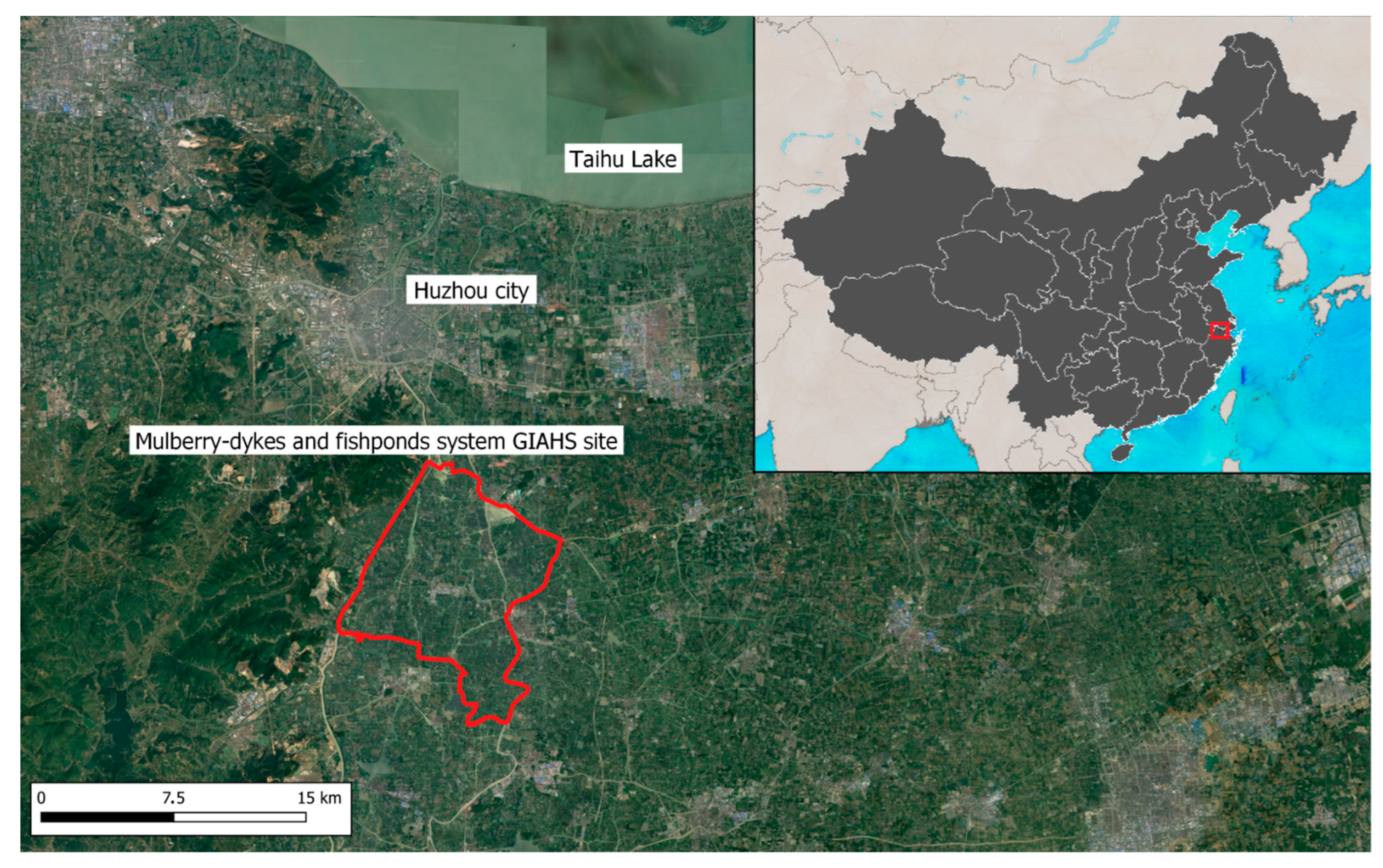
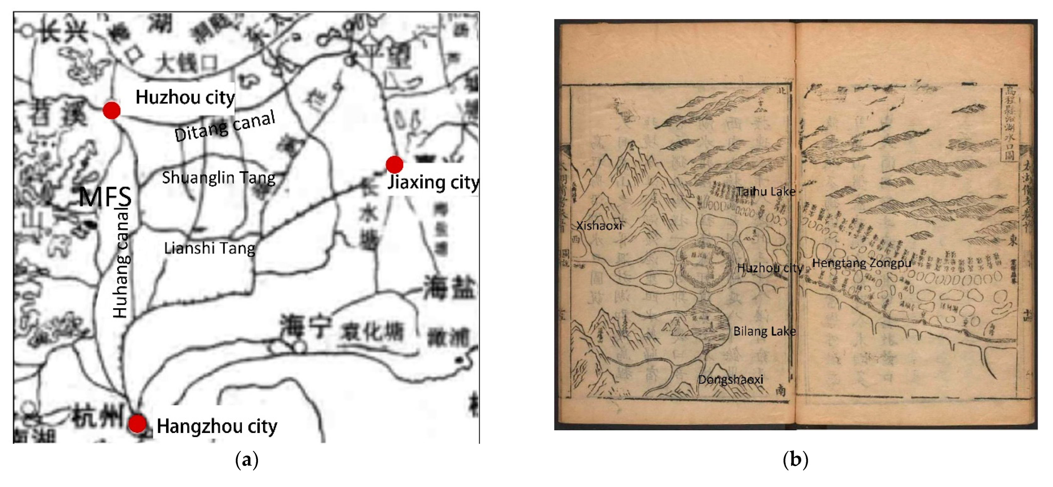
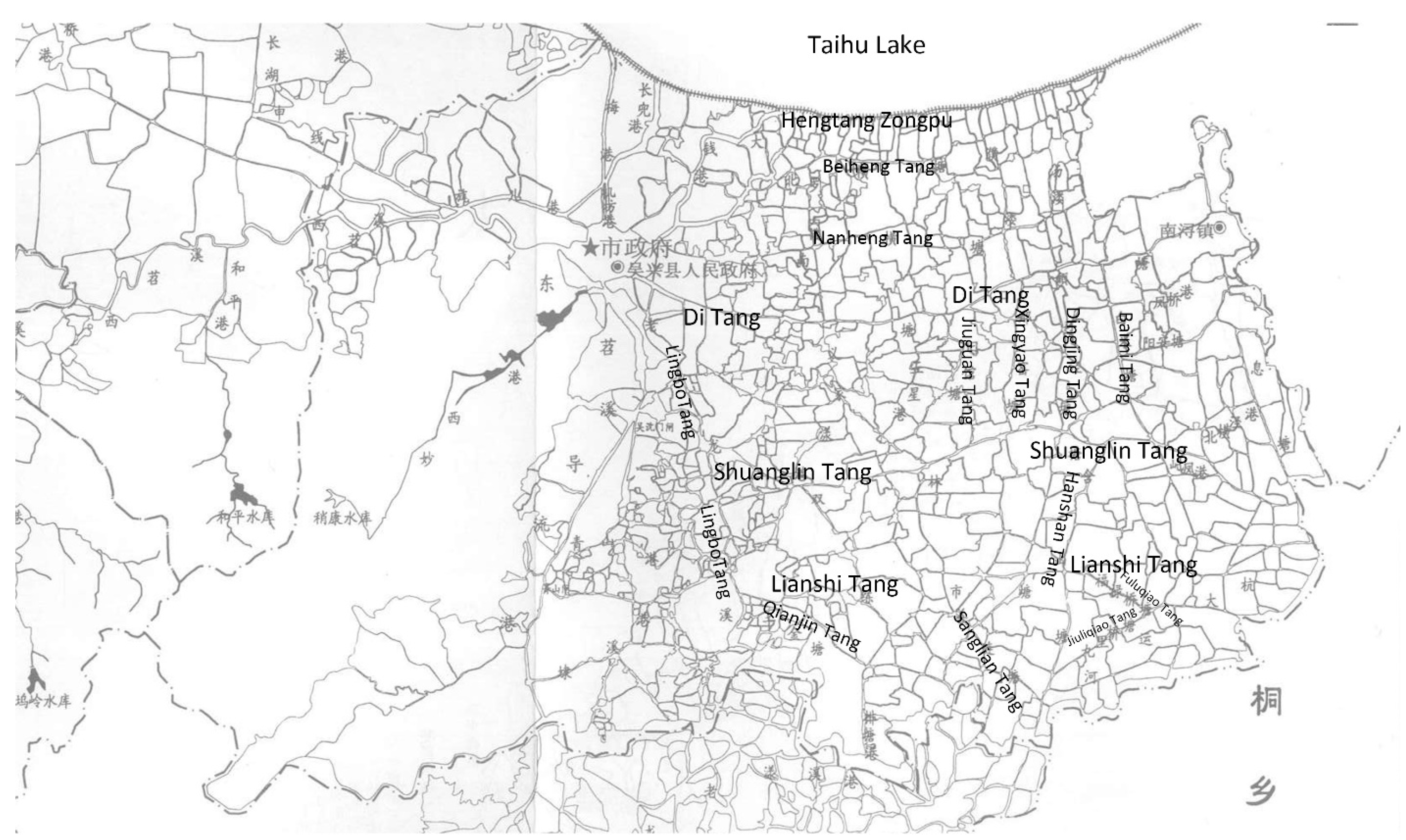
One of these systems is the mulberry-dykes and fishponds system (MFS), located near Huzhou city, Zhejiang province, China. This system is based on fishponds and on small cultivations practiced on the earth dykes dividing the ponds, with particular attention to mulberry trees for silkworm production. This site is recognized at a global level for its sustainability and for the strong interlinkages between mulberry cultivation and fish raising, testified by its inclusion in 2017 into the Globally Important Agricultural Heritage Systems (GIAHS) Programme established by the Food and Agriculture Organization (FAO), whose aim is to identify and preserve agricultural systems of global importance with their landscapes, biodiversity and agro-biodiversity, traditional knowledge, and associated culture [27,28]. The choice of focusing this research on an area included in this program is due to the fact that that is the main world programme specifically dedicated to cultural landscapes and to traditional agricultural and agroforestry systems. Therefore, the inclusion in this programme certifies the global importance of the system itself. In fact, in this area, traditional activities carried out by generations of farmers created a sustainable agricultural heritage system, but also shaped the land to adapt to difficult environmental conditions (the excess of water and recurring floods), creating a unique cultural landscape.
This paper intends to reduce the knowledge gaps associated with ancient agroforestry systems developed as a consequence of reclamation for flood control in peri-urban areas, also considering that the protection and restoration of existing flood control systems is considered a key issue [29,30]. In addition, despite the fact that this system is considered by FAO of global importance, in the last few years rural areas close to major Chinese cities have been under big pressure due to urban sprawl as a consequence of internal migration from countryside towards big cities [31]. In particular, the aims of the paper are: (i) to carry out a multitemporal analysis to measure land use changes in the last 12 years to evaluate the level of integrity and the main threats; (ii) to evaluate the effectiveness of the inclusion into the GIAHS Programme regarding land use changes and landscape transformation mitigation. The findings of this research could be used by local stakeholders and by the GIAHS Secretariat as a baseline for future monitoring, and also for improving their strategies and as a support of local and regional territorial planning.

2. Materials and Methods

2.1. The Study Area

The study focuses on the mulberry-dykes and fishponds agroforestry system (MFS), which extends for 9456 ha within the Huzhou City jurisdiction, Zhejiang province, China (Figure 1). The area is located in Jiahu Low Plain in the southern of Taihu Plain, with an elevation of 3–4 m a.s.l., while the geomorphic type is mainly a lacustrine plain [32]. Its southwest is the Tianmu Mountains, and the streams Dongshaoxi and Xisiaoxi, originating from the Tianmu Mountains, are some of the main runoffs that flow into Taihu Lake. In Jiahu Low plain, the Dongshaoxi flows slowly, forming many lakes and rivers. It flows northward through MFS and successively through Huzhou City, and merges with the tributaries of Xisiaoxi into Taihu Lake. According to the Köppen-Geiger climate classification, the local climate is Cfa—Humid subtropical climate [33], with significant differences between summer and winter (average yearly temperature of 16.3 °C, average temperature of the coldest month of 3.7 °C, average temperature of the hottest month of 28.5 °C). Average rain per year is 1386 mm, unevenly distributed, with little rainfalls in winter and heavy rains in summer [34]. When heavy rainfall occurs, the water level of Dongshaoxi rises rapidly, representing the main reason for why Jiahu Low Plain suffers from recurring floods; therefore, different strategies were adopted in different times in history to deal with the flood risk.
The MFS is a complex and sustainable agricultural heritage system with strong interlinkages between the main components: mulberry trees and fishes. Mulberry roots reinforce the dykes, while leaves are harvested to feed silkworms (Bombyx mori) for the silk industry, and silkworm excrement is used to feed fishes inside the ponds. Fishes traditionally represent the main source of proteins for the local population and five species of carps are commonly raised: black carp (Mylopharyngodon piceus), grass carp (Ctenopharyngodon idella), silver carp (Hypophthalmichthys molitrix), bighead carp (Aristichthys nobilis), and crucian carp (Carassius auratus). At the same time fish excrements enrich the pond muds, which are collected and used as fertilizers for mulberry trees and for other crops. Fishes also have an important role in controlling the growth of aquatic plants on the pond surface. Mulberries do not only provide leaves for feeding the silkworms, but also other products and byproducts to the local population: mulberry leaves can be used to produce mulberry tea to which traditional medicine associates different health benefits, or to produce mulberry leaf powder which can be used as an ingredient for human alimentation or for feeding animals. Branches and leaves of mulberry trees are also used for feeding sheep in the Taihu Lake area, where mutton is commonly consumed. Mulberry fruits can instead be turned into juice, jam, wine, ice cream, cakes, breads, and sauces.

2.2. The Historical Origin and Evolution of the Mulberry-Dykes and Fishponds Agroforestry System

The following is a brief summary of the origin and evolution of MFS through the analysis of local chronicles, maps, and monographs of various historical periods from the Song Dynasty (XI century) to the present, mainly derived from the analysis of the historical documents listed in Table 1.
Huzhou city is located in the intersection of the Dongshaoxi and Xishaoxi rivers. In ancient times, they were responsible for different floods in the region. During the Han Dynasty (202 BC–220 AD), the first canal connecting Jiaxing city to Suzhou city was built, while the Jiahang Canal from Hangzhou city to Jiaxing city was connected during the Tang Dynasty (618–907 AD). In the 12th century, during the Southern Song Dynasty (1127–1279 AD), the main channel, called Huhang Canal, was built to connect the cities of Hangzhou and Huzhou. At the same time, all the canal systems in the Jiahu Low Plain were refined, becoming the main water drainage system. This complex regional water canals system not only functioned as a flood control system, but channels also started to be used for transportation and irrigation [35] (Figure 2).
This regional canal system laid the foundation for the formation of the Tang system (Figure 3). A tang is a small channel with two dykes on both sides, so that each tang can be considered a secondary channel with the function of drainage and discharging water. During the Song Dynasty (960–1279 AD), many tangs were excavated in the south of Huzhou city: Wuxing Tang, Hongcheng Tang, and Baojia Tang were recorded in local chronicles [38]. The orientation of the tangs south of Huzhou city, where MFS is located, follows different directions. In addition to the traditional east–west tangs, there are also tangs with north–south direction, some of them longer (as Linghu Tang) and some shorter (such as Baimi Tang, Hanshan Tang, and Jiuguan Tang). The literature shows that the tangs in Huzhou area are different from those in other areas of the Taihu Lake Basin, as in this area they are connected to the streams coming from the mountains, therefore also serving as control systems for the streams flow [39]. The water from each tang is finally discharged into Taihu Lake by the Hengtang zonglou water system.
This reclamation system, based on main regional channels and smaller channels (tangs), originated a polder landscape that increased rapidly. Mulberry trees started to be planted on the banks of the tangs, while rice started to become the main crop of the polder landscape. Although sericulture and fishery have been traditional activities in the region since ancient times, the development of a continuous, specific, and integrated system of mulberry cultivation and fish raising system only started with the Ming Dynasty (XIV century). The causes of this transformation are multiple; firstly, the congestion of the drainage channels occurred, with the consequence of the increase of floods; secondly, the water level outside (in the channels) and inside (in the rice paddies) the polders was the same, therefore it was difficult to drain the water, causing a reduction of rice yields; thirdly, the increase of the local population and the development of the silk industry caused a growing demand of food and of mulberry trees for silkworms. These causes led to a change in the economic system and in the main agricultural activities, causing a land use transformation with many paddy fields that were turned into fishponds in order to reduce flood damage and to increase the economic profits and the food security, originating the mulberry-dykes and fishponds system [41].
After the replacement of most of the rice paddies with fishponds, the flood control system started to be mainly used to fill the ponds and for irrigation, thanks to gates that regulated the water exchange between the tangs and the polder. When the water level in the tang was higher than the polder, the gate was closed to avoid flooding; when the water level in the pond was lower than the polder, the gate was opened to divert water into the ponds. During possible floods, if the water level in the ponds was too high, waterwheels were used to drain water [42]. Therefore, the construction and management of dykes became extremely important to properly store the water and, therefore, ponds started to be dredged twice a year and the resulting silt started to be used to consolidate dykes and to fertilize mulberry trees at the same time.

2.3. Methodology

The first part of the methodology focused on the realization of land use maps for a multitemporal analysis of the land use changes in the last 12 years, from 2009 to 2021. In addition, an intermediate year was also analyzed (2018) to evaluate if the inclusion in the GIAHS Program (occurred in 2017) led to different trends in land use changes. In fact, analyzing the values and trends of the land use changes previously and after the inscription in the GIAHS Programme can help to understand the effectiveness of the inclusion in this FAO Programme regarding landscape transformations. The choice of the years is due to the availability of high-resolution images. The following satellite images taken by Maxar have been used: for 2009, images taken in April–May with a resolution equal to 55 cm; for 2018, images taken in December with a resolution equal to 43 cm; for 2021, images taken in May with a resolution equal to 43 cm. The detailed land use mapping was carried out through manual photointerpretation with the software ArcGIS 10.7 developed by ESRI (USA), allowing us to produce complete datasets and maps. The three datasets were then overlapped using the software QGIS 3.22.3 to detect land use changes in the two considered time intervals (2009–2018, 2018–2021), but also in the long period (2009–2021). This approach follows the VASA (Historical and Environmental Approach) methodology, which is based on the analyses of land use maps of at least two different years to measure landscape changes and trends in cultural landscapes to assess landscape changes, the overall level of integrity, and the main vulnerabilities [43]. The analysis of the land use changes between the different time intervals allows us to produce new layers with new polygons, each of them including information about the land use in the two different considered periods. On the basis of this information, each polygon was then classified according to a classification based on standard dynamics. With respect to the original VASA methodology, the names of some of the dynamics have been slightly changed to adapt to the specific characteristics of the study area (Table 2). From the analysis on dynamics, it was also possible to gain insight on traditional land uses; after identifying the portions of the study area characterized by traditional land uses in 2009, they have been compared with the categorization of the same areas in 2021 to detect whether these areas retained or not the traditional land uses. In addition, the Sharpe Index has been calculated to highlight the significance of certain processes with regard to land use transformations that have occurred in the given historical period in the considered study area. The Sharpe Index is applied to individual types or classes of land use and can take on a positive or negative value. If the index assumes a positive value, it means that the considered land use increased its surface in the reference period, while if the value takes a negative sign the land use decreased in terms of overall surface. The index does not only consider the extensions of the different land uses in terms of hectares, but also the time interval, therefore the resulting graph is based on the significance of the land use changes in terms of intensity. The Sharpe Index is calculated as follows:
S h a r p e I n d e x = ( p k 2 p k 1 t 2 t 1 ) / S
where: pk1 is the surface of the land use pk at year t1 expressed in hectares; pk2 is the surface of the land use pk at year t2 expressed in hectares; t2t1 is the time interval expressed in years (t2 > t1); S is the total surface of the study area expressed in km2.
The final produced datasets could also represent a baseline for future monitoring and planning.
The second part of the applied methodology focused on an in-depth analysis regarding traditional fishponds. Specific punctual shapefiles have been realized—one for each year (2009, 2018, 2021) through QGIS 3.22.3. Points have been placed in correspondence of each traditional fishpond in order to create a complete database and to allow further spatial analysis and metrics calculation. Finally, starting from these three punctual shapefiles, a density analysis has been performed and related maps have been produced on the basis of a 5-hectares hexagon grid created with QGIS 3.22.3 with the MMQGIS plug-in. The use of hexagons to carry out density analysis of specific landscape features is due to the fact that this kind of shape offers two main advantages: (i) any given point inside a hexagon is closer to the center of that hexagon respect to the use of other shapes of the same size (i.e., square, triangle); (ii) hexagons are the only geometric shape for regular tessellations that shares a real border with every neighbor [44]. The choice of the size of the hexagon is made on the basis of previous experiences and according to the overall extent of the study area, bearing in mind that changes in the hexagons extent can lead to different results of landscape metrics [45]. For each year, the number of ponds for each hexagon has been calculated to obtain average and maximum values, and density maps that could also serve as a baseline for future monitoring.

3. Results

3.1. The Land Use Changes from 2009 to 2021

The landscape of 2009 was mainly represented by the traditional mulberry-fishpond system, which occupied 38.9% of the total study area, followed by modern ponds for intensive fish raising (20.3%), by channels (17.2%), and by other cultivations (13.5%). Traditional villages were found on 5.4% of the total surface, while the rest of the anthropic areas (areas under construction, modern build up areas, roads) accounted for 3.9% of the area (Table 3). The 2009 land use map (Figure 4) shows that modern ponds for intensive fish raising started to spread in specific portions of the study area, especially in the east and south-east parts, while a big patch classified as area under construction was found in the middle of the area.
The landscape of 2018 appears to be completely different (Figure 4). The main change regards the traditional mulberry-fishpond system, which occupied only 11.2% of the total area, mainly concentrated in few portions of the study area. The most common land use was the modern ponds for intensive fish raising (50.7%), highlighting a crucial shift between these two land uses in the period 2009–2018.
The analysis of the 2021 landscape allowed us to obtain updated data and to check the efficiency of the GIAHS inclusion to mitigate and/or stop some trends. In 2021, both the traditional mulberry-fishpond system and the modern ponds for intensive fish raising show a decrease in the surface with respect to 2018, probably due to the replacement with other land uses. Part of this trend is surely due to the introduction of solar panels on wide surfaces in the north-east part of the study area, which were not present in 2009. The increase of the surface classified as uncultivated land (only 40 ha in 2009, more than 176 in 2021) is related to the presence of agricultural abandonment, while many big patches classified as areas under construction highlight that the urban sprawl is still going on, especially in the central and south-western parts of the GIAHS site.
The multitemporal analysis allowed us to measure the land use changes in detail for the different time intervals, paying particular attention to the period 2018–2021, the period after the inscription to the GIAHS Programme. The main trends in the long period (2009–2021) are the agricultural intensification occurring on 33.2% of the surface, followed by the urban sprawl (7.1%) and by the spread of solar panels (3,4%); more than the half of the MFS GIAHS site is classified as unchanged (Table 4). Regarding the agricultural intensification, it has to be considered that 64.8% corresponds to the replacement of traditional mulberry-fishpond system with intensive fishponds.
In the period 2018–2021 (Figure 5), 91% of the total surface is classified as unchanged. Despite this high percentage, it has to be noted that some negative trends have still continued over the last few years. In particular, urban sprawl occurred on 4.5% of the territory, at an average rate of more than 140 ha/year, mainly represented by a few big patches scattered in the central and southern part of the area that have a higher visual impact than small and evenly distributed new single buildings. This urban sprawl rate is particularly high, considering that before the GIAHS recognition (in the period 2009–2018) it was equal to 32 ha/year.
Photovoltaic systems were not present in 2009, but they have been rapidly introduced in the area, as in 2018 they already occupied more than 295 ha (3.1% of the total area), represented by big solar farms in the north-eastern part of the GIAHS site. This trend has not been stopped by the GIAHS recognition, as in the period 2018–2021 a new solar farm has been realized (Figure 5), bringing the overall surface of this land use to 317 ha (3.4%). In addition, about half (47%) of the surface used for solar panels in 2021 was occupied by the traditional mulberry-fishpond land use in 2009.
Agricultural intensification, mainly corresponding to the replacement of the traditional mulberry-fishpond system with intensive fishponds, is a still ongoing process in the last three years, taking place on 2.1% of the total surface, but at a significant lower rate (67 ha/year) with respect to the period 2009–2018 (360 ha/year), as testified by the dynamic maps (Figure 5) that clarify how this process mainly occurred before the GIAHS recognition. The same trend that affected traditional mulberry-fishpond system also involved land classified as other cultivations. In fact, an important part of the other cultivations (870 ha out of the 1280 ha in 2009) have been replaced with intensive fishponds.
Major changes also occurred in the settlement typologies. Traditional villages decrease their surface in the period 2018–2021—from 510 ha in 2009, to 493 ha in 2018, to 462 in 2021. This decrease is due both to their replacement with modern built-up areas (199 ha in 2009, 365 ha in 2018, 416 ha in 2021) and to the construction of new roads (55 ha in 2009, 59 ha in 2018, 96 ha in 2021). This trend has continued over the last few years, as testified by the fact that for 2021 more than 518 ha have been classified as areas under construction.
An in-depth analysis of the land use changes between 2009 and 2021, of which we have so far summarized the most important trends, is shown in the cross-tabulation (Table 5). The number in each cell reports change (or unchanged) surface in hectares between 2009 (on the rows) and 2021 (on the columns).
The Sharpe index (Figure 6) confirms that the two most threatened land use types are traditional mulberry-fishpond system and other cultivations, while the type that has undergone the greatest expansion in terms of surface and intensity corresponds to the intensive fishponds.
The dynamics that involve traditional landscape are represented in Figure 7. Only 30% of the 4188 ha of traditional land uses in 2009 has been preserved until 2021, decreasing from 44% of the total surface of the study site to only 13%, mainly due to the loss of the traditional mulberry-fish pond system areas and secondly to the loss of traditional villages.

3.2. The Spatial Analysis of Traditional Fishponds

The spatial analysis of the traditional fishponds in the period 2009–2021 allowed us to obtain interesting data about their number and density. As a natural consequence of the reduction of the surface occupied by the traditional mulberry-fishpond system land use, the total number of traditional fishponds decreased (Table 6). The change does not only involve the total number, but also the density of traditional fishponds on the surface of traditional mulberry-fishpond system land use, which decreased from 3.2 ponds/ha for 2009, to 2.1 ponds/ha for 2018, and to 1.6 ponds/ha for 2021. This reduction is due to the fact that in the last years fishponds have been partly enlarged, affecting the ratio between the mulberry dykes and the fishpond surface, as well as the overall traditional landscape structure that survives only in specific portions of the GIAHS site.
The density analysis of fishponds based on the hexagon grid allows to deepen the spatial analysis of traditional fishponds in the considered time frame. In 2009, 20.5% of the total number of hexagons included more than 10 traditional fishponds, reaching a maximum value of 46 ponds/hexagon and an average value of 5.8 ponds/hexagon (Figure 8). In 2018, these values decreased, with 1.8% of the total number of hexagons including more than 10 traditional fishponds, a maximum value of 23 ponds/hexagon and an average value of 1.1 ponds/hexagon. The situation in 2021 is even worse, with only 0.2% of the total number of hexagons including more than 10 traditional fishponds, a maximum value of 20 ponds/hexagon and an average value of 0.7 ponds/hexagon. If we consider the range 1–10 ponds/hexagon, in 2009 the percentage of traditional ponds falling within this range was equal to 49.5%, decreasing to 26% in 2018 and to 19% in 2021. The density maps based on the same hexagon grid (Figure 9) clarify how in 2021 only a few portions of the entire GIAHS sites have a number of traditional fishponds/ha that can be compared to the one of 2009, while in 2009, traditional fishponds, and the related traditional mulberry-fish pond system land use, were more evenly distributed within the GIAHS site.

4. Discussion

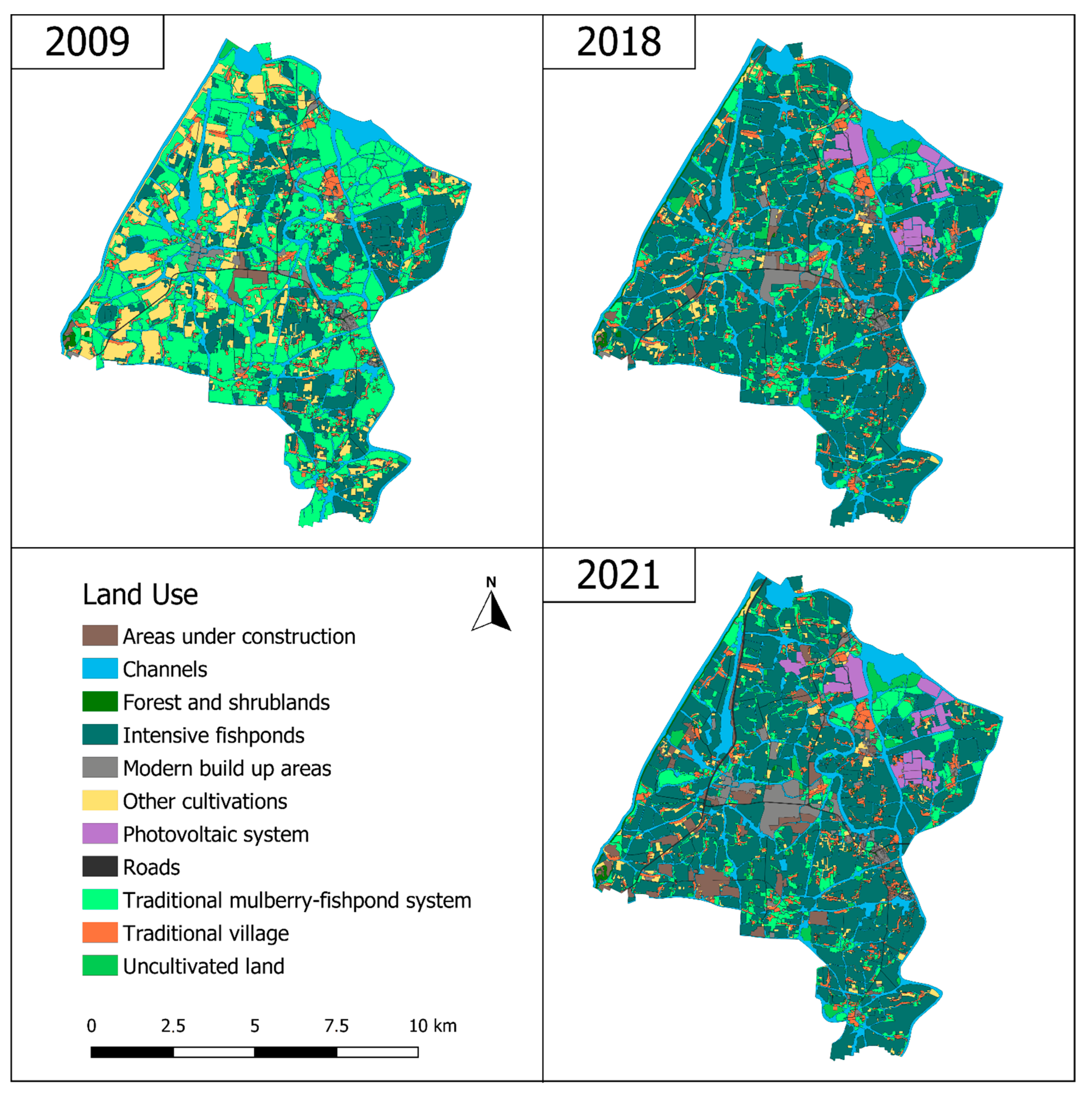
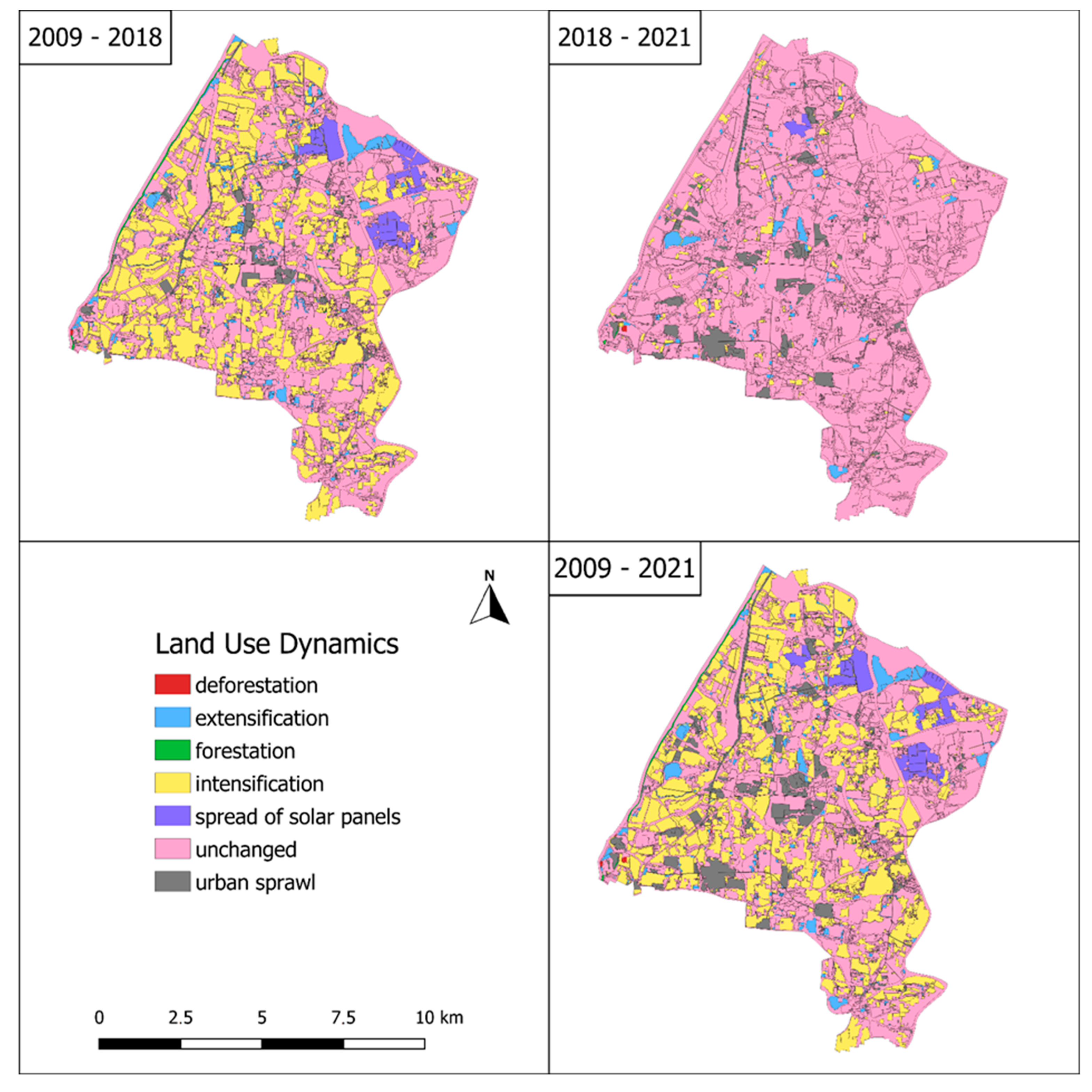
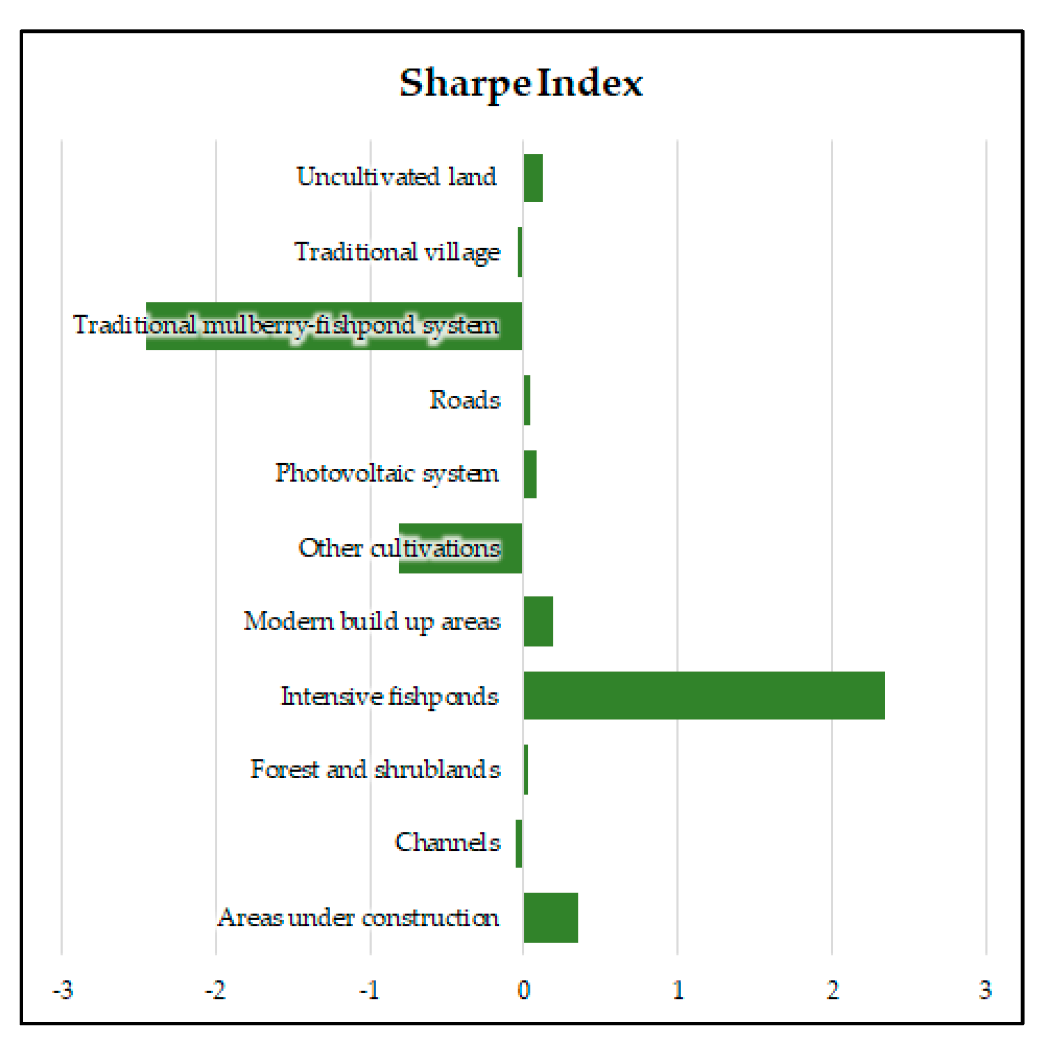
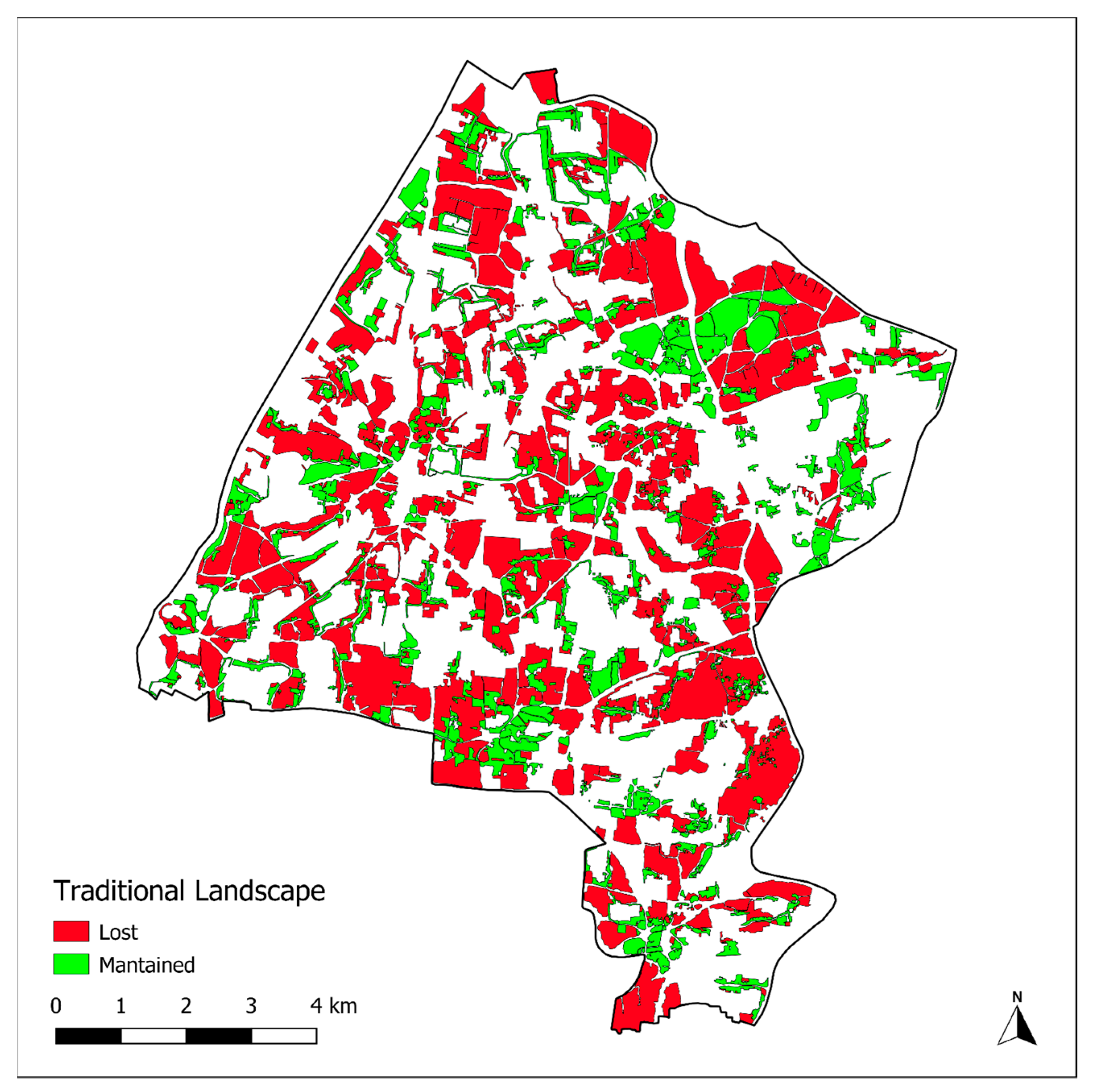
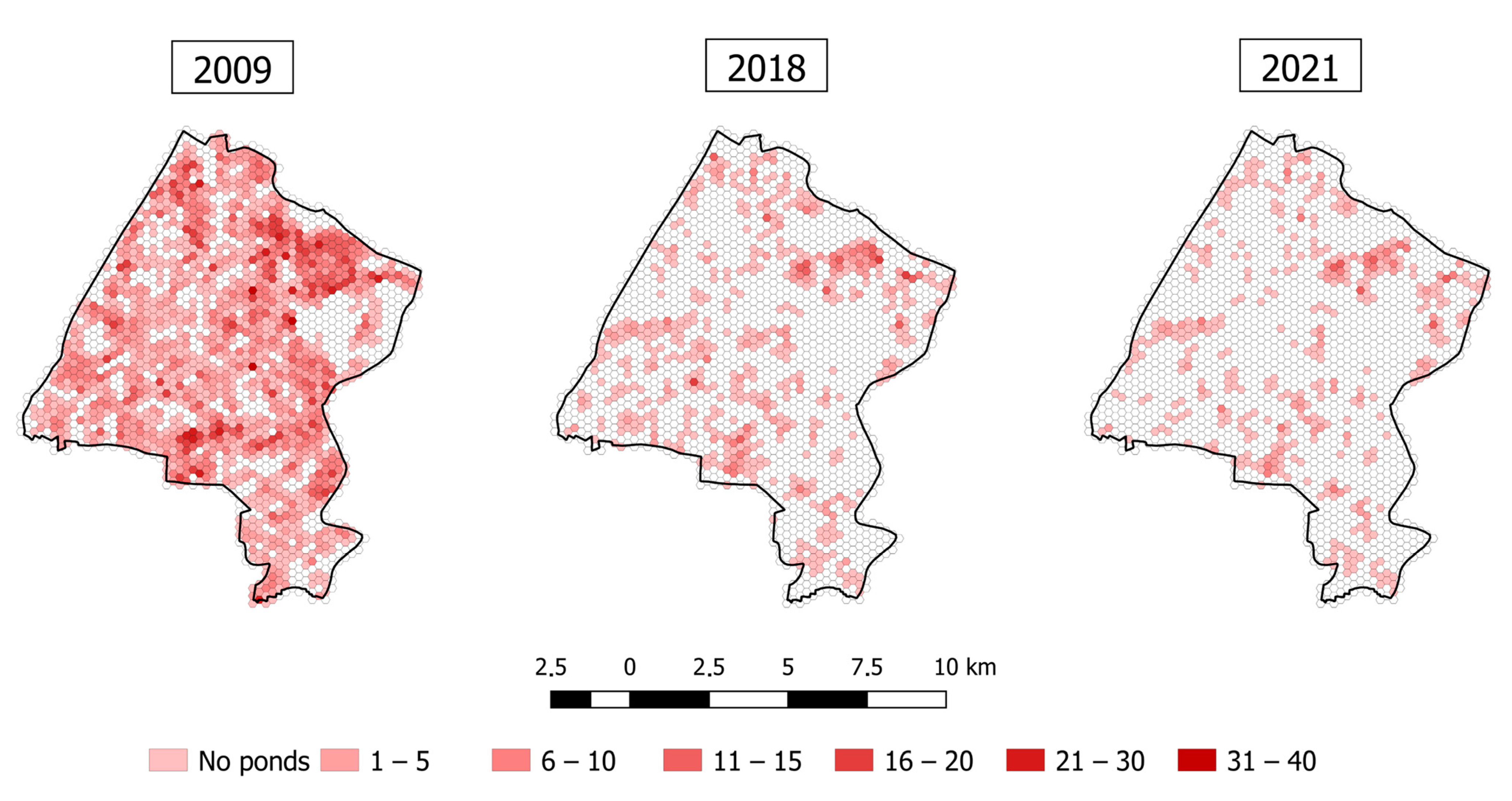
The results of our analyses demonstrate that MFS has undergone major land use changes in the last 12 years, and that the main causes are urban sprawl, spread of solar panels, and abandonment of the traditional mulberry-based systems in favor of modern fish-raising ponds. Traditional mulberry-fish pond system land use suffered a decrease of −2778 ha (−75%), while intensive fishponds increased by 2665 ha.
The first thing to be considered is that MFS GIAHS site is located near a major city, and is therefore suffering big pressure due to urban sprawl. According to Su et al. [46]. Tiaoxi watershed experienced rapid socioeconomic development during the last 25 years, mainly as a consequence of population growth, which increased from 2.09 million to 19.32 million, with a net growth of 8.2%. This is also confirmed by our results, as in the last 12 years modern built-up areas have increased by +52%, while traditional villages decreased by −4.3%. The growth of new urban and industrial areas and of infrastructures caused higher levels of fragmentation and isolation of the agricultural patches, which became less abundant and connected and became more irregular and fragmented at a landscape level. Urban sprawl and the replacement of traditional villages with modern residential areas is not an uncontrolled process, and is mainly the consequence of a provincial policy whose aim is to promote the agglomeration of population, industries, and functions at a county and town level [47].
Urban and industrial sprawl are not only causing problems for landscape connectivity and the preservation of the local agroforestry system, but are also responsible for water and air pollution. According to Xiao et al. [48], water quality is highly dependent on the landscape characteristics, and their investigation carried out in Huzhou City proved that local land use change is responsible for the deterioration of river water quality, since landscape pattern controls various biogeochemical and physical processes, with the final consequence being that water pollution not only leads to an alteration of the river ecosystem, but also threatens public health and socio-economic sustainability. In addition, emissions can also affect the mulberry trees and the local silk industry, as the fluoride pollution in mulberry leaves negatively affects the yields of the silkworm cocoon [49].
The other major threat regarding land use change, is due to the spread of photovoltaic systems, which reached a surface equal to 317 ha, with a +7% in the period 2018–2021. This trend is not surprising, even if it is deeply affecting the local landscape, since it is in line with national and regional trends. In 2019, China accounted for 32.6% of the world’s overall installed capacity of photovoltaic power, mainly thanks to regional and national policies carried out in the last decade. For example, Zhejiang province launched aggressive policies to support photovoltaic systems in the early 2010s, becoming the first province according to the cumulative installed capacity [50]. Despite some policies being specifically aimed at placing solar panels on the rooftop of houses (as the Million Households Project), and therefore minimizing the impacts on productive surfaces, our study demonstrated that the spread of solar panels in the area mainly occurred on agricultural surfaces. The spread of solar panels, even if it is important for increasing the amount of clean energy, should be carefully evaluated, in particular within agricultural heritage systems, especially because of the negative consequences on landscape perception and on the aesthetic value of the traditional landscape. In this regard, results showed that photovoltaic systems are not small solar panels evenly distributed within the area but are big solar farms with an average size of about 17 ha, thus maximizing the impact on the local landscape from a perceptive point of view.
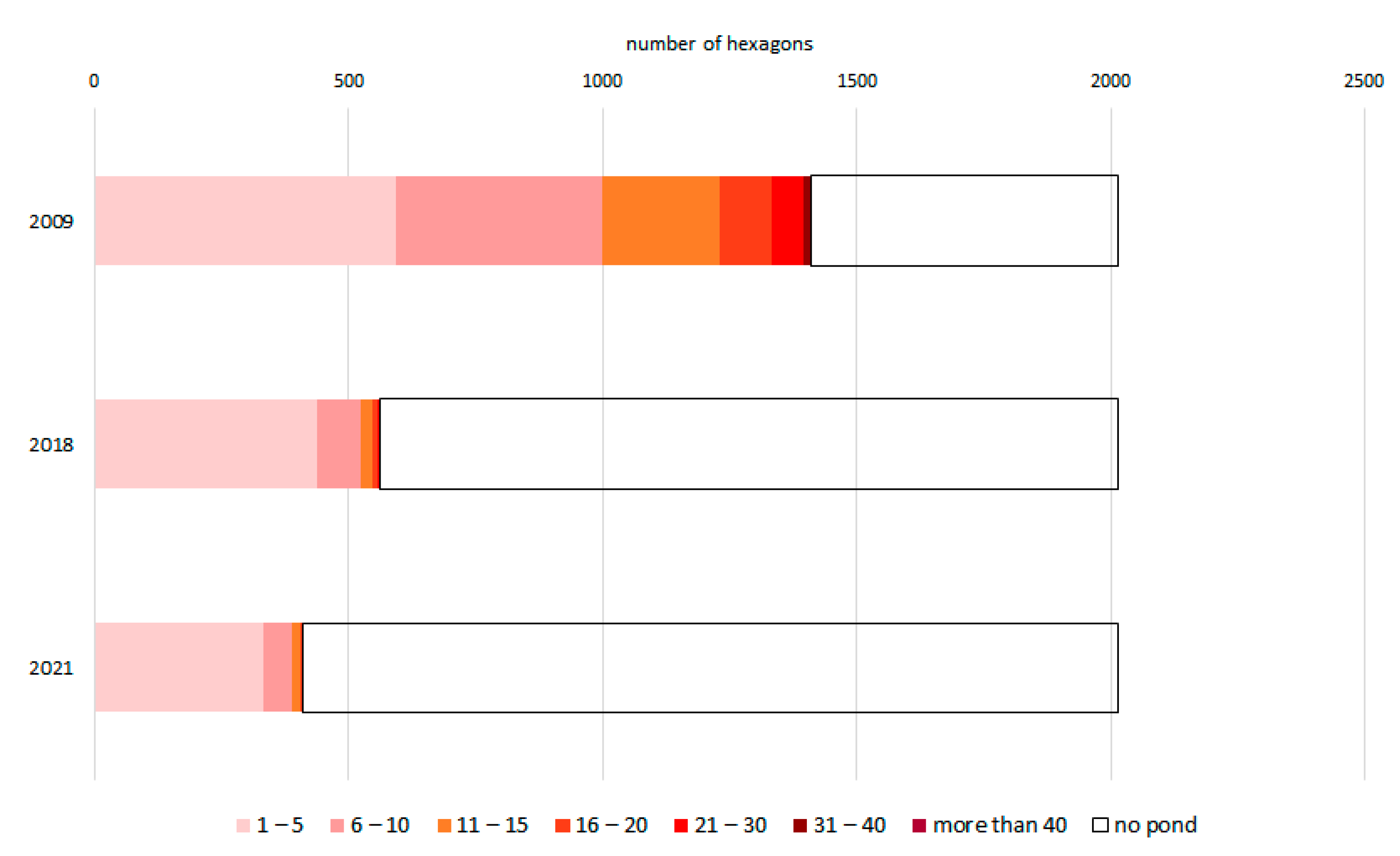
Other changes are instead related to the shape and size of traditional fishponds and on the abandonment of the practice of planting and managing mulberry trees on the dykes. According to the findings of our study, fishpond numbers decreased by −81% in the period 2009–2018 and by −33% in the period 2018–2021. At the same time, the irregular or oval shape of the traditional ponds is often replaced by square and bigger ponds, as reported by Ye et al. [51], who found that the dyke–pond ratio changed from 6:4 to 3:7 or 2:8 in the last years. This is partly due to the strategy of “taking the road of agricultural modernization with Chinese characteristics”, which was firstly explicitly put forward at the 17th National Congress of the Chinese Communist Party in 2007 to increase agricultural production and ensure farmers’ incomes. As a result, China entered a period of increasing agricultural modernization aiming to narrow the gap between urban and rural areas. After that, in 2017 the “Rural Revitalization” strategy was proposed at the 19th National Congress of the Chinese Communist Party to better integrate agriculture, farmers, industry, and urban areas. At the local level, these policies have favoured the development of a modern aquaculture paying attention to environmental aspects, but not to traditional landscape and heritage [52,53].
In addition, due to industrialization of the silk production, traditional techniques that relied on manual skills are not applied anymore, and with the cessation of the use of stilt to fertilize mulberries, accumulated at the bottom of the ponds, the water level became shallow, and fish diseases increased. The inclusion in the GIAHS Programme brought some improvements at a management level, but did not solve the main vulnerabilities. After the recognition of MFS as GIAHS in 2017, dredging of the ponds has been organized [54], even if with a reduced frequency compared with the twice a year dredging commonly practiced in ancient times. The use of mulberries planted among fishponds and the functional linkages and exchanges among trees and fishponds are common to various agroforestry systems in China [55], but the decrease of the traditional and integrated system with mulberries and fishponds, with the replacement of modern fishponds, turns this system in an intensive fish-raising system, while the agroforestry component and the related benefits and services for the environment and the local population are disappearing. The progressive loss of traditional agroforestry systems, despite the recognized importance at the scientific level, is not only happening in China, but also in other countries and continents, as in Europe. The main cause is the spread of intensive agriculture, with the consequent reduction of the overall sustainability of the systems [56,57], of the related Ecosystem Services and biodiversity [58,59], and also of the energy efficiency and of the financial benefits to farmers [60]. In this sense, the reduction of the surface devoted to the agroforestry system is particularly relevant considering recent research. Zhang and Liu [61], who performed a study on the importance and sustainability of agroforestry based on 118 China National Important Agricultural Heritage Systems (China-NIAHS), found that agroforestry is strongly correlated with different sustainability indicators (including biodiversity, income diversity, resource utilization, hydrogeological preservation, water regulation). The same authors asked for promoting agroforestry in order to enhance the sustainability of agricultural productive systems. The assessment of the different Ecosystem Services related to agricultural heritage system, and of their economic value, could also represent an important indicator, even if it is not exempt from criticalities [62]. Although the GDP per capita increased in Huzhou City in the period 1996–2001 from 15.03 thousand Yuan to 19.10 thousand Yuan, the total Ecosystem Services value decreased from 19.48 billion Yuan to 17.36 billion Yuan [63]. Another problem is the lack of participation and awareness of farmers in relation to the GIAHS recognition and values. This problem is not only related to the MFS, but is also common to other Chinese GIAHS sites, as demonstrated by Siyuan et al. [64], who found that being often a top-down initiative, farmers think that conservation is something that has to deal with the government and not with them, and therefore, GIAHS is not still perceived as an effective tool to encourage farmers to become active in conservation unless they do not receive economic benefits. In this regard, Siyuan et al. suggest that there is a need for turning non-economic values into economic values within agricultural heritage systems, i.e., providing farmers with conservation subsidies, as with the maintenance of their traditional activities they contribute to providing different Ecosystem Services to all the community. Xingguo et al. [65] identified different vulnerabilities in the protection and planning of agricultural heritage systems in Zhejiang Province, including imperfect management of heritage sites, low participation of community residents, and lack of special protection funds. The same authors propose five different countermeasures. Among them, the improvement of the management structure and the development of a regional branding of agricultural products coming from GIAHS sites can have a potentially important role for the MFS. Rural tourism can instead be crucial for diversifying farmers’ incomes and can therefore entice farmers to maintain their traditional activities.
Expanding the discussion from the Chinese sites to the GIAHS Programme in general, it is important to remember that every GIAHS site represents a long history of development, trial and error, and innovation, as rural communities have adapted to changing conditions in both the human and ecological systems [66]. Since socio-economic conditions are always changing, it is not possible to consider a GIAHS site as an immutable system only because it is included in the FAO Program. Therefore, since the GIAHS Programme has been established 20 years ago, it appears urgent to monitor the status of the inscribed sites, not only of the ones included in the Programme in the first years, but of all of them, as our study proved that even in a reduced time interval, major changes can occur. FAO has not yet set any standardized GIAHS monitoring, leaving it to the discretion of each GIAHS site to conduct voluntary self-evaluation. This is a major concern in relation to the future of the GIAHS Programme, and according to Jiao et al. [67] there is the need to develop a scientific-based monitoring systems for GIAHS, not only to highlight the conservation needs or the threats, but to contribute to the sustainable development of the heritage site. Reyes et al. proposed a set of indicators to monitor GIAHS sites [68], including “Land use/land cover change statistics” and “Policies and regulations related to agriculture”. The findings of our study highlight that monitoring landscape and land use changes is crucial to measure the effective level of conservation of the agricultural heritage system, to identify the main threats and the main trends, but can also be fundamental for evaluating the effectiveness and for addressing local and regional territorial planning and policies.

Local Territorial Planning and Projects

Failure to recognize the ecological and cultural value of MFS has resulted in early protection and utilization not being coordinated with other urban and rural planning, land use planning, and water conservancy planning. The main planning tools at a local level are summarized in Table 7. Modern water conservancy projects, such as the construction of large reservoirs, Dongshaoxi Flood Control Project, Lou Gang Dredging Project, and the embankment reconstruction project, have been carried out one after another, contributing to solving the flood problem and providing security for agricultural production, and also introducing some criticalities. For example, the Dongshaoxi Flood Control Project focused on the water storage and irrigation of the western hills area, ignoring the irrigation demand of the eastern plain. Dongshaoxi has always been the main irrigation source of the eastern plain for ensuring high quality products, especially the fish raised in the MFS. Similarly, in the project of increasing the elevation of the dykes to improve flood control, the traditional use of silt to fertilize mulberry trees planted on the dykes was not considered, highlighting a severe lack of coordination between different local projects dealing with flood control and agricultural production. At the same time, past urban planning paid little attention to the process of protection of agricultural heritages, which was instead better considered in the newest urban plan (2017–2035) that proposed to build a network of blue–green public spaces based on a multi-tiered ecological pattern; this is the result of a better awareness regarding the urban water system, which is no longer only perceived as an important flood control system, but also as a public space. In fact, after becoming a Chinese National Important Agricultural Heritage System (NIAHS) in 2014, the multi-functional and multiple values of MFS started to be valued. The established MFS leading group, composed of various municipal departments (agriculture, development and reform, finance, water conservancy, culture, tourism, land, construction, environmental protection, and others), started to improve the organization and coordination among various departments [69]. However, cooperation of professionals in specific planning group is not yet emphasized adequately.
The inclusion in the GIAHS Programme has instead highlighted the cultural heritage linked to the MFS, contributing to promote touristic activities based on its unique landscape, traditional knowledge, and culture [70]. Rural tourism focused on the development of scenic spots, farmhouse accommodation, cultural and creative products, shops for ecological agricultural products, and outdoor entertainment activities. According to 2016 official data, the area received more than 1 million tourists, and the revenue of rural tourism was about 40 million yuan [71]. The increasing touristic attractiveness, together with the GIAHS labelled products, the promotional activities the cultural festivals related to the MFS, the educational activities in primary and secondary schools, and training activities for farmers, all contribute to bring relatively high income to the local farmers and to support the active conservation of the traditional system, but also to the creation of new jobs opportunities at a local level [70]. In addition, a special protection fund by means of government allocation has been set to provide subsidies and rewards to village groups that manage and restore traditional fishponds. However, local plans have eased the disappearance of mulberry ponds, but cannot avoid the overall trend of disappearance. The main problem seems to be that the economic benefits brought by this model (government subsidies, agricultural operations, rural tourism, etc.) to farmers are weaker than the economic benefits brought by agricultural modernization.

5. Conclusions

The mulberry-dykes and fishponds agroforestry system (MFS) is considered an agricultural heritage system of global importance by the FAO, and is an example of a traditional Chinese ancient agroforestry system developed through the centuries as a result of a flood control system to protect Huzhou city from recurring floods. The study demonstrated that this system is currently affected by several threats, in particular by urban sprawl (including the spread of photovoltaic systems) and agricultural intensification. The study also demonstrated that the inclusion in the GIAHS Programme was not sufficient to stop negative trends affecting the traditional system, but partly contributed to slow down these trends. In addition, after the GIAHS inscription, local planning tools started to progressively recognize the importance of the traditional MFS. The applied methodology proved to be effective in measuring land use changes, in identifying the main threats, and in characterizing the spatial pattern of the fishponds, providing a large amount of data that can be used to inform and address local planning as well as the GIAHS secretariat, and that can also represent a baseline for future monitoring. A limitation of the study is that it is restricted to the GIAHS site, while it would be interesting to check if the identified pressures and threats (urban sprawl, photovoltaic systems, agricultural intensification) are taking place with different intensity outside the GIAHS site borders. Another limitation is that the study focused on the landscape changes taking place only in the last 12 years, while it also would be interesting to analyze the previous situation; unfortunately, it was not possible to find high-quality aerophotos or satellite images prior to 2009.
On one side, MFS developed and evolved as a consequence of the past needs of the local populations, in particular as the result of a flood control system that protected Huzhou from floods, but also as the consequence of the local farmers’ needs to obtain agricultural products, first rice, then mulberry leaves for the local silk industry and fishes for human consumption. On the other side, these needs are still evolving and changing, and new expectations and services are demanded from rural areas, especially from peri-urban ones in a country where land use changes can take place very fast. Nowadays, the need of new residential areas for people moving from marginal areas towards the surrounding of big cities and the need of producing clean energy are contributing to deeply transform the local landscape structure, affecting the traditional agroforestry system. The consequence is that a system recently recognized of global importance by the FAO is currently facing major pressures and changes, with the possible consequence of its disappearance in the near future. In addition, it has to be considered that the importance of MFS is not only related to the cultural heritage or as an example of adaptation and mitigation, but also to its effectiveness in reducing flood risk. To protect and valorize this unique agroforestry system (but also similar ones), it would be necessary to develop adequate and specific planning instruments and policies at a local level that would consider the range of ecosystem services provided by MFS, and not only the economic value based on the final agricultural products. In this sense, the training of younger generations can be crucial for increasing the awareness of the role of this system for sustainable agriculture and flood risk mitigation; at the same time, rural tourism can contribute to provide additional incomes to local farmers. More generally, it is necessary to regularly monitor agricultural and agroforestry heritage systems, and in particular the ones inscribed in the GIAHS Programme as they are considered of global importance by the FAO, but also the cultural landscapes included in the UNESCO World Heritage List, with a standard methodology and measurable indicators, to provide data for informing planners, therefore contributing to their preservation for future generations. In this sense, it is important to recognize the multiple values and ecosystem services related to MFS, in particular by the local stakeholders, that directly or indirectly affect the site through their strategies and actions. Therefore, a closer communication and cooperation among various stakeholders is required to better coordinate their aims. On the other side, it is important to strengthen farmers’ identification in ecological, economic, and cultural aspects, and to promote their active participation and involvement in local planning, especially as farmers are the main actors, bearers, and disseminators of knowledge, culture, and values.

Author Contributions

Conceptualization, A.S., Q.Y. and F.P.; methodology, A.S., Q.Y. and F.P.; software, A.S., Q.Y. and F.P.; writing—original draft preparation, A.S., F.P., Q.Y., B.F. and A.B.; supervision, A.S. and M.A. All authors have read and agreed to the published version of the manuscript.

Funding

This research received no external funding.

Data Availability Statement

Data available on request.

Conflicts of Interest

The authors declare no conflict of interest.

References

  1. Jose, S. Agroforestry for ecosystem services and environmental benefits: An overview. Agrofor. Syst. 2009, 76, 1–10. [Google Scholar] [CrossRef]
  2. Fagerholm, N.; Torralba, M.; Burgess, P.J.; Plieninger, T. A systematic map of ecosystem services assessments around European agroforestry. Ecol. Indic. 2016, 62, 47–65. [Google Scholar] [CrossRef]
  3. Shin, S.; Soe, K.T.; Lee, H.; Kim, T.H.; Lee, S.; Park, M.S. A systematic map of agroforestry research focusing on ecosystem services in the Asia-Pacific Region. Forests 2020, 11, 368. [Google Scholar] [CrossRef] [Green Version]
  4. Verchot, L.V.; Van Noordwijk, M.; Kandji, S.; Tomich, T.; Ong, C.; Albrecht, A.; Mackensen, J.; Bantilan, C.; Anupama, K.V.; Palm, C. Climate change: Linking adaptation and mitigation through agroforestry. Mitig. Adapt. Strateg. Glob. Chang. 2007, 12, 901–918. [Google Scholar] [CrossRef] [Green Version]
  5. Raj, A.; Jhariya, M.K.; Yadav, D.K.; Banerjee, A. (Eds.) Climate Change and Agroforestry Systems: Adaptation and Mitigation Strategies; CRC Press: Boca Raton, FL, USA, 2020. [Google Scholar]
  6. Abbas, F.; Hammad, H.M.; Fahad, S.; Cerdà, A.; Rizwan, M.; Farhad, W.; Ehsan, S.; Bakhat, H.F. Agroforestry: A sustainable environmental practice for carbon sequestration under the climate change scenarios—A review. Environ. Sci. Pollut. Res. 2017, 24, 11177–11191. [Google Scholar] [CrossRef]
  7. Lake, I.R.; Hooper, L.; Abdelhamid, A.; Bentham, G.; Boxall, A.B.; Draper, A.; Fairweather-Tait, S.; Hulme, M.; Hunter, P.R.; Nichols, G.; et al. Climate change and food security: Health impacts in developed countries. Environ. Health Perspect. 2012, 120, 1520–1526. [Google Scholar] [CrossRef] [PubMed]
  8. Atwoli, L.; Baqui, A.H.; Benfield, T.; Bosurgi, R.; Godlee, F.; Hancocks, S.; Horton, R.; Laybourn-Langton, L.; Monteiro, C.A.; Norman, I.; et al. Call for emergency action to limit global temperature increases, restore biodiversity, and protect health: Wealthy nations must do much more, much faster. Nutr. Rev. 2021, 79, 1183–1185. [Google Scholar] [CrossRef] [PubMed]
  9. Ebi, K.L.; Boyer, C.; Bowen, K.J.; Frumkin, H.; Hess, J. Monitoring and evaluation indicators for climate change-related health impacts, risks, adaptation, and resilience. Int. J. Environ. Res. Public Health 2018, 15, 1943. [Google Scholar] [CrossRef] [PubMed] [Green Version]
  10. Islam, T.; Atkins, P. Indigenous floating cultivation: A sustainable agricultural practice in the wetlands of Bangladesh. Dev. Pract. 2007, 17, 130–136. [Google Scholar] [CrossRef] [Green Version]
  11. Keskinen, M. The Lake with floating villages: Socio-economic analysis of the Tonle Sap Lake. Int. J. Water Resour. Dev. 2006, 22, 463–480. [Google Scholar] [CrossRef]
  12. Bala, H.; Ghosh, A.K.; Kazal, M.M.H.; Rahman, M.S.; Sultana, M.; Sujan, M.H.K. Floating gardening in Bangladesh: A sustainable income generating activity in wetland areas. Int. J. Agric. Res. Innov. Technol. 2020, 10, 87–93. [Google Scholar] [CrossRef]
  13. Chowdhury, R.B.; Moore, G.A. Floating agriculture: A potential cleaner production technique for climate change adaptation and sustainable community development in Bangladesh. J. Clean. Prod. 2017, 150, 371–389. [Google Scholar] [CrossRef]
  14. Oo, M.T.; Aung, Z.W.; Puzzo, C. The floating garden agricultural system of the Inle lake (Myanmar) as an example of equilibrium between food production and biodiversity maintenance. Biodivers. Conserv. 2022, 31, 2435–2452. [Google Scholar] [CrossRef]
  15. Coe, M.D. The chinampas of Mexico. Sci. Am. 1964, 211, 90–99. [Google Scholar] [CrossRef]
  16. Pérez-Belmont, P.; Lerner, A.M.; Mazari-Hiriart, M.; Valiente, E. The survival of agri-culture on the edge: Perceptions of push and pull factors for the persistence of the ancient chinampas of Xochimilco, Mexico City. J. Rural. Stud. 2021, 86, 452–462. [Google Scholar] [CrossRef]
  17. Liu, S.; Min, Q.; Jiao, W.; Liu, C.; Yin, J. Integrated emergy and economic evaluation of Huzhou mulberry-dyke and fish-pond systems. Sustainability 2018, 10, 3860. [Google Scholar] [CrossRef] [Green Version]
  18. Abramson, D.B. Ancient and current resilience in the Chengdu Plain: Agropolitan development re-‘revisited. ’ Urban Stud. 2020, 57, 1372–1397. [Google Scholar] [CrossRef]
  19. Wilhelm, J.A.; Smith, R.G. Ecosystem services and land sparing potential of urban and peri-urban agriculture: A review. Renew. Agric. Food Syst. 2018, 33, 481–494. [Google Scholar] [CrossRef]
  20. Brinkley, C. Evaluating the benefits of peri-urban agriculture. J. Plan. Lit. 2012, 27, 259–269. [Google Scholar] [CrossRef] [PubMed] [Green Version]
  21. Lwasa, S.; Mugagga, F.; Wahab, B.; Simon, D.; Connors, J.; Griffith, C. Urban and peri-urban agriculture and forestry: Transcending poverty alleviation to climate change mitigation and adaptation. Urban Clim. 2014, 7, 92–106. [Google Scholar] [CrossRef]
  22. Gyasi, E.A.; Kranjac-Berisavljevic, G.; Fosu, M.; Mensah, A.M.; Yiran, G.; Fuseini, I. Managing threats and opportunities of urbanisation for urban and peri-urban agriculture in Tamale, Ghana. In The Security of Water, Food, Energy and Liveability of Cities; Springer: Dordrecht, The Netherlands, 2014; pp. 87–97. [Google Scholar]
  23. Ferreira, A.J.D.; Guilherme, R.I.M.M.; Ferreira, C.S.S. Urban agriculture, a tool towards more resilient urban communities? Curr. Opin. Environ. Sci. Health 2018, 5, 93–97. [Google Scholar] [CrossRef]
  24. O’Gorman, P.A. Precipitation Extremes Under Climate Change. Curr. Clim. Chang. Rep. 2015, 1, 49–59. [Google Scholar] [CrossRef] [PubMed] [Green Version]
  25. Westra, S.; Fowler, H.J.; Evans, J.P.; Alexander, L.V.; Berg, P.; Johnson, F.; Kendon, E.J.; Lenderink, G.; Roberts, N.M. Future changes to the intensity and frequency of short-duration extreme rainfall: Future intensity of sub-daily rainfall. Rev. Geophys. 2014, 52, 522–555. [Google Scholar] [CrossRef] [Green Version]
  26. Eekhout, J.P.; Hunink, J.E.; Terink, W.; de Vente, J. Why increased extreme precipitation under climate change negatively affects water security. Hydrol. Earth Syst. Sci. 2018, 22, 5935–5946. [Google Scholar] [CrossRef] [Green Version]
  27. Koohafkan, P.; Altieri, M.A. Globally Important Agricultural Heritage Systems: A Legacy for the Future; Food and Agriculture Organization of the United Nations: Rome, Italy, 2011. [Google Scholar]
  28. Ramakrishnan, P.S. Globally Important Ingenious Agricultural Heritage Systems (GIAHS): An Eco-Cultural Landscape Perspective; GIAHS Background Document; Food and Agriculture Organization: Rome, Italy, 2004. [Google Scholar]
  29. Cook, H.F. Floodplain agricultural systems: Functionality, heritage and conservation: Floodplain agricultural systems. J. Flood Risk Manag. 2010, 3, 192–200. [Google Scholar] [CrossRef]
  30. Kiedrzyńska, E.; Kiedrzyński, M.; Zalewski, M. Sustainable floodplain management for flood prevention and water quality improvement. Nat. Hazards 2015, 76, 955–977. [Google Scholar] [CrossRef] [Green Version]
  31. Ma, L.; Tang, Y. Geography, trade, and internal migration in China. J. Urban Econ. 2020, 115, 103181. [Google Scholar] [CrossRef]
  32. Huang, X. Taihu Liuyu Guihua He Zonghe Zhili [Taihu Lake Basin Planning and Comprehensive Management]; China Water & Power Press: Beijing, China, 2020. [Google Scholar]
  33. Kottek, M.; Grieser, J.; Beck, C.; Rudolf, B.; Rubel, F. World Map of the Köppen-Geiger climate classification updated. Meteorol. Z. 2006, 15, 259–263. [Google Scholar] [CrossRef]
  34. Huzhou Water Conservancy Compilation Committee. Huzhou Shuili Zhi [The Local Chronicles of Huzhou Water Conservancy]; Encyclopedia of China Publishing House: Beijing, China, 1989. [Google Scholar]
  35. Wang, J.; Zhou, Q. Songyuan shiqi Jiangnan yunhe dui Jiahu pingyuan weitian tixi de yingxiang [Influence of Jiangnan Canal on Jiaxing and Huzhou Plain’s Polder System in Song and Yuan Dynasties]. Landsc. Archit. 2019, 26, 21–27. [Google Scholar] [CrossRef]
  36. Zheng, Z. Taihu Shuili Jishu Shi [The History of Hydraulic Technology in the Lake Taihu Region]; China Agriculture Press: Beijing, China, 1987. [Google Scholar]
  37. Jin, Y. Taihu Beikao [Chronicles of Taihu Lake]; Jiangsu Ancient Books Publishing House: Nanjing, China, 1998. [Google Scholar]
  38. Tan, Y. Jiatai Wuxing Zhi [the Local Chronicles of Wuxing County]; Wuxing District People’s Government: Huzhou, China, 2010; Volume 19, p. 11b. [Google Scholar]
  39. Zhou, Q. Tangsong shiqi Taihu nanan pingyuan qu nongtian shuili geju de xingcheng [The formation of farmland water conservancy pattern of the plain area on the south bank of Taihu Lake during the Tang and Song dynasties]. J. Chin. Hist. Geogr. 2010, 25, 47–55. [Google Scholar]
  40. Lu, D.; Wang, X. Study on the System of Lougang by Huzhou Lake and Tangpu (Lougang) Polder; A Compilation of Research and Research Results on the Huzhou Pugang and Tangpu Polder Systems; Zhejiang Association for Science and Technology: Hangzhou, China, 2005; pp. 4–43. [Google Scholar]
  41. Wang, J. Yuanming shiqi Jiahu diqu de hewang weitian yu shizhen [The river network, polders and towns in the Jiahu area during the Yuan and Ming dynasties]. Hist. Rev. 2012, 4, 75–88+190. [Google Scholar]
  42. Zhou, Q. Qing minguo shiqi dongshao xi xiayou de sangji yutang yu shuitu huanjing [During the Qing Dynasty, the Mulferry dike & fish pond and water and soil environment in the lower reaches of Dongshaoxi]. Agric. Hist. China 2013, 32, 80–90. [Google Scholar]
  43. Agnoletti, M.; Emanueli, F.; Corrieri, F.; Venturi, M.; Santoro, A. Monitoring traditional rural landscapes. The case of Italy. Sustainability 2019, 11, 6107. [Google Scholar] [CrossRef]
  44. Adamczyk, J.; Tiede, D. ZonalMetrics—A Python toolbox for zonal landscape structure analysis. Comput. Geosci. 2017, 99, 91–99. [Google Scholar] [CrossRef]
  45. Venturi, M.; Piras, F.; Corrieri, F.; Fiore, B.; Santoro, A.; Agnoletti, M. Assessment of Tuscany Landscape Structure According to the Regional Landscape Plan Partition. Sustainability 2021, 13, 5424. [Google Scholar] [CrossRef]
  46. Su, S.; Wang, Y.; Luo, F.; Mai, G.; Pu, J. Peri-urban vegetated landscape pattern changes in relation to socioeconomic development. Ecol. Indic. 2014, 46, 477–486. [Google Scholar] [CrossRef]
  47. General Office of Zhejiang Provincial Government. 12th Five-Year Plan of Zhejiang Province for the Development of New-Type Urbanization. The People’s Government of Zhejiang Province Portal Website. 14 July 2012. Available online: https://www.zj.gov.cn/art/2012/7/14/art_1229019364_63872.html (accessed on 27 October 2022).
  48. Xiao, R.; Wang, G.; Zhang, Q.; Zhang, Z. Multi-scale analysis of relationship between landscape pattern and urban river water quality in different seasons. Sci. Rep. 2016, 6, 25250. [Google Scholar] [CrossRef] [Green Version]
  49. Xichuan, B.; Jianxin, W.; Jin, X. Effects of time distribution of fluoride pollution in mulberry leaves at the stage of spring silkworm on the yield of silkworm cocoon. Can Ye Ke Xue Canye Kexue Acta Sericologica Sin. 2001, 27, 313–317. [Google Scholar]
  50. Yu, H.; Tong, X. Producer vs. local government: The locational strategy for end-of-life photovoltaic modules recycling in Zhejiang province. Resour. Conserv. Recycl. 2021, 169, 105484. [Google Scholar] [CrossRef]
  51. Ye, M.; Lou, L.; Qian, W.; Jin, Q.; Shen, N. Huzhou sangji yutang xitong xingcheng jiqi baohu yu fazhan xianshi yiyi [Huzhou Mulberry-fish pond system formation and its practical significance for protection and development]. China Mod. Agric. Dev. Forum Proc. 2014, 117–123. [Google Scholar]
  52. People’s Government of Hefu Town. Implementation Opinions of Hefu Town on Supporting the Development of Modern Agricultural Industry (2019–2021). Nanxun People’s Government Website, Huzhou, China: 31 May 2019. Available online: http://www.nanxun.gov.cn/hzgov/front/s369/xxgk/zcfg/gfxwj/20190812/i2298065.html (accessed on 3 August 2022).
  53. Zhejiang Provincial Government. Zhejiang Provincial Action Plan for Comprehensively Implementing the Rural Revitalization Strategy and Promoting High-level Agricultural and Rural Modernization (2018–2022); Ministry of Agriculture and Rural Affairs of the People’s Republic of China Website, Hangzhou, China: 12 April 2018. Available online: http://www.moa.gov.cn/ztzl/xczx/gh_24713/201812/t20181203_6164270.htm (accessed on 11 August 2022).
  54. Jin, Q.; Wu, H.; Lou, L. Zhejiang Huzhou Sangji Yutang Xitong Baohu Yu Fazhan Jiance Jixian Xianzhuang Yu Jianyi [Current Status and Suggestions of Baseline Monitoring for Protection and Development of Mulberry Dyke & Fish Pond System in Huzhou, Zhejiang Province. Bull. Seric. 2019, 50, 38–42. [Google Scholar]
  55. Zou, X.; Sanford, R.L. Agroforestry systems in China: A survey and classification. Agrofor. Syst. 1990, 11, 85–94. [Google Scholar] [CrossRef]
  56. Krčmářová, J. Loss of Agroforestry: Symbolic Annihilation of Mixed Cultures in 19 Century Agricultural Science. Eur. Countrys. 2020, 12, 618–635. [Google Scholar] [CrossRef]
  57. Ferrario, V. Learning from agricultural heritage? Lessons of sustainability from Italian “coltura promiscua”. Sustainability 2021, 13, 8879. [Google Scholar] [CrossRef]
  58. Santoro, A.; Venturi, M.; Bertani, R.; Agnoletti, M. A review of the role of forests and agroforestry systems in the FAO Globally Important Agricultural Heritage Systems (GIAHS) programme. Forests 2020, 11, 860. [Google Scholar] [CrossRef]
  59. Agnoletti, M.; Santoro, A. Agricultural heritage systems and agrobiodiversity. Biodivers. Conserv. 2022, 31, 2231–2241. [Google Scholar] [CrossRef]
  60. Jianbo, L. Energy balance and economic benefits of two agroforestry systems in northern and southern China. Agric. Ecosyst. Environ. 2006, 116, 255–262. [Google Scholar] [CrossRef]
  61. Zhang, M.; Liu, J. Does Agroforestry Correlate with the Sustainability of Agricultural Landscapes? Evidence from China’s Nationally Important Agricultural Heritage Systems. Sustainability 2022, 14, 7239. [Google Scholar] [CrossRef]
  62. Spangenberg, J.H.; Settele, J. Precisely incorrect? Monetising the value of ecosystem services. Ecol. Complex. 2010, 7, 327–337. [Google Scholar] [CrossRef]
  63. Yu, D.Y.; Pan, Y.-Z.; Wang, Y.-Y.; Liu, X.; Ling, J.; Long, Z.-H. Valuation of ecosystem services for Huzhou city, Zhejiang Province from 2001 to 2003 by remote sensing data. Journey For. Res. 2005, 16, 223–227. [Google Scholar]
  64. Siyuan, H.; Heyao, L.; Qingwen, M. Is GIAHS an effective instrument to promote agrosystem conservation? A rural community’s perceptions. J. Resour. Ecol. 2020, 11, 77–86. [Google Scholar] [CrossRef]
  65. Xingguo, G.; Wenjun, J.; Yehong, S.; Bin, W. Conservation of the Important Agricultural Heritage Systems in the economically developed area: Experiences, problems and solutions—A case study of Zhejiang Province. J. Resour. Ecol. 2021, 12, 513–521. [Google Scholar] [CrossRef]
  66. Fuller, A.M.; Min, Q.; Jiao, W.; Bai, Y. Globally Important Agricultural Heritage Systems (GIAHS) of China: The challenge of complexity in research. Ecosyst. Health Sustain. 2015, 1, 1–10. [Google Scholar] [CrossRef]
  67. Jiao, W.; Zhao, G.; Min, Q.; Liu, M.; Yang, L. Building a monitoring system for globally important agricultural heritage systems (GIAHS) based on the monitoring experience of world heritage. Zhongguo Shengtai Nongye Xuebao/Chin. J. Eco-Agric. 2020, 28, 1350–1360. [Google Scholar]
  68. Reyes, S.R.C.; Miyazaki, A.; Yiu, E.; Saito, O. Enhancing sustainability in traditional agriculture: Indicators for monitoring the conservation of globally important agricultural heritage systems (GIAHS) in Japan. Sustainability 2020, 12, 5656. [Google Scholar] [CrossRef]
  69. Office of Huzhou Municipal People’s Government. Management Measures of MFS Reservation in Huzhou City, Huzhou Archives Information Network. 2014. Available online: https://daj.huzhou.gov.cn/show-38-2930-1.html (accessed on 5 August 2022).
  70. Yongxun, Z.; Lulu, H. Protecting Important Agricultural Heritage Systems (IAHS) by Industrial Integration Development (IID): Practices from China. J. Resour. Ecol. 2021, 12, 555–566. [Google Scholar] [CrossRef]
  71. Agriculture and Forestry Bureau of Nanxun District. Letter from the Agriculture and Forestry Development Bureau of Nanxun District of Huzhou City on the Reply to Recommendation No. 51 of the Second Session of the 4th District People’s Congress, Nanxun People’s Government Portal Website. 31 October 2018. Available online: http://www.nanxun.gov.cn/hzgov/front/s355/xxgk/jytabl/20181031/i2278457.html (accessed on 5 August 2022).
Figure 1. The mulberry-dykes and fishponds agroforestry system GIAHS site is located immediately south of Hozhou city, near Taihu Lake, in Eastern China.
Land 11 01920 g001
Figure 2. Map of the canal system of Huzhou area for the year 1987 [36] (a) and map of regional water system of Gui’an county (Huzhou city) (1750–1795) [37] (b).
Land 11 01920 g002
Figure 3. Map of the current water system of Huzhou City and location of Tangs [40].
Land 11 01920 g003
Figure 4. Land use maps of the MFS GIAHS site for the years 2009, 2018, and 2021.
Land 11 01920 g004
Figure 5. Maps of the land use changes.
Land 11 01920 g005
Figure 6. Sharpe Index graph.
Land 11 01920 g006
Figure 7. Map of the evolution of traditional land uses in the period 2009–2021.
Land 11 01920 g007
Figure 8. Graph of the number of ponds per hectare for the years 2009, 2018, and 2021.
Land 11 01920 g008
Figure 9. Density maps of the fishponds for the years 2009, 2018, and 2021.
Land 11 01920 g009
Table 1. Main historical sources analyzed for investigating the origin and the evolution of MFS.
Historical PeriodLocal ChroniclesHistorical MapsMonograph
Tang and Song dynasties (VII-XIII centuries)The local chronicles of Wuxing County (1201)
Ming and Qing dynasties (XIV-XX centuries)The local chronicles of Wuxing County (1614); The local chronicles of Huzhou city (1874); The local chronicles of Linghu Town (1893)The water inlet of Taihu lake along Wucheng County (1750–1795); Map of Gui’an County (1874); Map of waterways in Gui’an County (1878);Water conservancy survey in western Zhejiang (1878);
From the Qing Dynasty to the presentGazetteer of Huzhou City, Zhejiang Province (1982); The local chronicles of Huzhou water conservancy (1989)Current status map of the polder system in Tangpu (Lougang) of Huzhou City (20th century); Water system map of Huzhou City (1982)The history of hydraulic technology in the Lake Taihu region; Taihu Lake basin planning and comprehensive management; History of irrigation engineering technology in ancient China
Table 2. The dynamics used for classifying the land use changes in the period 2009–2021.
DynamicDescription
UnchangedThe main type of land use remains the same during the time interval, or when there is a change between similar land uses (i.e., from traditional village to modern buildings, or different types of tree cultivations).
Urban sprawlReplacement of natural or agricultural land uses with urban areas, infrastructures, or buildings.
Spread of solar panelsDue to the specificalities of the study area, it has been decided to leave this dynamic separated from the previous one.
IntensificationThe transformation from low-consumption land uses (in terms of biomass removal, mechanization, fertilizer, and crop protection products) to land uses characterized by high specialization and by a high need of energy supplies, i.e., the replacement of the traditional mulberry-fish ponds system with modern fishponds of regular shape without mulberries planted on the dykes.
ExtensificationThe opposite of the previous dynamic, which is rarely linked to a return to traditional land uses, but more often is due to the abandonment of the traditional system now replaced by uncultivated land.
ForestationProcess in which trees or shrubs occupy lands once used for agricultural activities.
DeforestationRemoval of woodlands or shrublands for obtaining land for pastures or crops.
Table 3. Surface in hectares and percentages occupied by the different land uses in 2009, 2018, and 2021.
Land Use200920182021
ha%ha%ha%
Areas under construction117.361.24189.802.01518.185.48
Channels1627.4417.211595.1416.871561.1916.51
Forest and shrublands28.090.3058.010.6158.540.62
Modern built-up areas199.652.11365.003.86416.524.40
Other cultivations1280.4413.54402.194.25363.813.85
Photovoltaic systems--294.393.11317.133.35
Traditional mulberry-fish pond system3678.5938.901057.7511.19900.919.53
Intensive fishponds1919.9820.304798.1850.744584.6948.48
Roads54.610.5859.250.6396.351.02
Traditional villages510.075.39492.645.21462.364.89
Uncultivated lands40.070.42144.141.52176.391.87
Total9456.50100.009456.50100.009456.50100.00
Table 4. Surface of the land use dynamics (in hectares and percentages) for the different time intervals.
Land Use Dynamic2009–20182018–20212009–2021
ha%ha%ha%
Deforestation3.910.02.530.05.890.1
Extensification342.473.6184.181.9351.053.7
Forestation36.710.43.510.037.880.4
Intensification3253.2234.4200.422.13135.2933.2
Spread of solar panels294.383.129.590.3317.133.4
Unchanged5241.1455.48609.5591.04938.7552.2
Urban spraw284.263.0426.634.5670.007.1
Total9456.50100.09456.50100.09456.50100.0
Table 5. Cross-tabulation of land use changes between 2009 and 2021. The colors of the cells are the same of the ones used for the legend of the maps of the land use changes in Figure 5.
2021
2009Areas under ConstructionChannelsForest and ShrublandsModern Build up AreasOther CultivationsPhotovoltaic SystemTraditional Mulberry-Fish Pond SystemIntensive Fish-PondsRoadsTraditional VillagesUncultivated LandsTotal
Areas under construction26.95 0.8172.873.94 3.278.21 1.26 117.31
Channels7.971545.77 1.423.123.154.8335.383.70.151.951627.42
Forest and shrublands1.41 19.850.483.62 1.960.310.040.41 28.08
Modern build up areas13.050.05 179.762.23 3.940.380.110.010.09199.62
Other cultivations61.050.232.1341.82173.414.9758.46870.1212.936.2219.211280.52
Traditional mulberry-fish pond system310.238.275.0387.32140.15148.25774.792014.0919.3529.05141.73678.23
Intensive fish-ponds68.752.54 24.9718.21140.7647.571595.085.715.810.531919.92
Roads0.090.07 0.17 0.110.5953.560.01 54.6
Traditional villages21.87 0.067.98.1 5.2120.340.48445.460.8510.22
Uncultivated lands6.764.260.66 10.83 0.814.210.46 2.0940.07
Total518.131561.1658.54416.54363.76317.13900.944558.7196.34488.37176.379455.99
Table 6. Variation in the number and density of traditional fishponds in the period 2009–2021.
200920182021
Number of traditional ponds11,62221921468
Surface of traditional mulberry-fish pond system (ha)3678.591057.75900.91
Average density of traditional ponds (n/ha)3.22.11.6
Table 7. Summary of the main planning tools at local level dealing with MFS.
PlanningMain Addressed Topics in Relation to MFS
Hekou Reservoir engineering (1958–1965)Hekou reservoir is mainly used to detain water from Yuying Stream, a tributary of Dongtiaoxi. It is used to effectively retain flood, reduce flood peak flow of Dongtiaoxi, indirectly protect farmland in Deqing County, Huzhou city and other neighboring areas, reducing flood risk in Jiahu Low plain.
Dongshaoxi flood control project (1958–up to date)The Dongshaoxi flood control project can direct the flood discharge into Taihu Lake, control the flood invasion, and reduce the Jiahu Low plain flood pressure.
Lou Gang Dredging Project (yearly)Dredging projects shall be carried out for each Lou and Gang over the years on the original basis. Ensure the Dongshaoxi flood into the lake channel smoothly.
Reconstruction project of irrigated area in polder area of eastern plain of Huzhou city (1986–1990)The first phase of the project selected 8 irrigated areas in 6 townships, including Zhenxi and Hongtang in Shuanglin and Lianchi districts, which are key production areas of commodity grain. The top height of polder dykes is 5.8 m, the top width of dykes is 2 m. The Mulberry belt is built on the dyke, which is 2 m wide and 4.5 m high. It can withstand a 20-year flood disaster.
Protection and restoration of agricultural heritage in MFS (2013)Repair Mulberry and fishpond year by year. Regular dredging and obstruction clearing of rivers, lakes, and ponds, as well as regulation and improvement of water quality of rivers in the protected areas.
Protection and restoration of core reservation area of MFS (2014)Fishpond dredging, raising fish, and mulberry planting.
Master Plan of Huzhou City (2003–2020)Control of the city’s important lakes; Control of important river channels in cities
Master Plan of Huzhou City (2017–2035)Urban blue and green public space system
Publisher’s Note: MDPI stays neutral with regard to jurisdictional claims in published maps and institutional affiliations.

